A Level Geography
SpecificationPearson Edexcel Level 3 Advanced GCE in Geography (9GE0)First teaching from September 2016First certification from 2018 Issue 5

Summary of Pearson Edexcel Level 3 Advanced GCE in Geography (9GEO) Specification Issue 5 changes
Summary of changes made between previous issue and this current issue
Page number
Amendments for consistency and clarification of wording and in the use of globe symbols: 2A2a, 2A3a, 2A8a, 2B1c, 2B3a, 2B3c, 2B5a, 2B5c, 2B7a, 2B9b, 2B11b, 2B12b, 3.1b, 4A8, 4A10 and 4B7b
17, 19, 20, 22, 23, 24, 25, 28, 32, 36, 37, 39, 42
6.1c - We have reworded the sentence ‘Geological processes release carbon into the atmosphere through volcanic out-gassing at ocean ridges/subduction zones and chemical weathering of rocks’. And amended it to read ‘Chemical weathering removes carbon from silicate rocks. The carbon ends up in the ocean as carbonate rock. Carbon is released via outgassing at ocean ridges, hotspot volcanoes and subduction zones’.
46
If you need further information on these changes or what they mean, contact us via our website at: qualifications.pearson.com/en/support/contact-us.html.

Contents
1 Introduction 2 Why choose Edexcel A Level Geography? 2 Supporting you in planning and implementing this qualification 3 Qualification at a glance 4
2 Subject content and assessment information 6 Area of study 1: Dynamic Landscapes 10 Area of study 2: Dynamic Places 24 Area of study 3: Physical Systems and Sustainability 41 Area of study 4: Human Systems and Geopolitics 51 Fieldwork 67 Non-examination assessment: Independent Investigation 68
3 Assessment information 82 Assessment Objectives 84
4 Administration and general information 85 Entries 85 Access arrangements, reasonable adjustments, special consideration and malpractice 85 Student recruitment and progression 88
Appendix 1: Geographical skills 91
Appendix 2: Fieldwork skills 93
Appendix 3: Definitions 94
Appendix 4: Exam command word definitions 95
Appendix 5: Geography independent investigation form 96
Appendix 6: Descriptions of the level of independence required at different stages of the Independent Investigation 98
Appendix 7: Independent investigation mark sheet 100
Appendix 8: Fieldwork statement 107
Appendix 9: The context for the development of this qualification 108
Appendix 10: Transferable skills 110
Appendix 11: Level 3 Extended Project qualification 111
Appendix 12: Codes 113
Appendix 13: Rationale for Teacher Guidance 114
Appendix 14: Geography NEA teacher guidance 117

Pearson Edexcel Level 3 Advanced GCE in Geography – Specification Issue 5 – March 2019 © Pearson Education Limited 2019
2
1 Introduction
Why choose Edexcel A Level Geography? We’ve listened to feedback from all parts of the geography subject community, including hundreds of fellow teachers. We’ve used this opportunity of curriculum change to redesign a qualification that is engaging and relevant to today’s geographers – a qualification that enables your students to engage critically with real world issues and places, apply their own geographical knowledge, understanding and skills to make sense of the world around them, and to help prepare them to succeed in their chosen pathway.
Engaging and contemporary issues-based approach
Our specifications offer an issues-based approach to studying geography, enabling students to explore and evaluate contemporary geographical questions and issues such as the consequences of globalisation, responses to hazards, water insecurity and climate change.
Supports progression to undergraduate level geography
The specification content gives students the opportunity to develop an in-depth understanding of physical and human geography, the complexity of people and environment questions and issues, and to become critical, reflective and independent learners.
Straightforward and flexible content structure
This specification has four equally-weighted content areas of study, offering both compulsory and optional content, assessed through three external assessments and one piece of non-examination assessment.
AS and A Level qualifications that are co-teachable
Centres co-teaching AS and A Level can deliver Area of study 1 Dynamic Landscapes and Area of study 2 Dynamic Places in the first year, allowing students to be entered for the AS at the end of year 12.
Clear assessments that offer all students the chance to succeed
Externally-examined papers provide gradual progression in demand throughout the topics and consistent use of 8 different command words so it is clear what the question is asking. Our A Level Geography non-examination assessment is straightforward to deliver and manageable.
Confidence in geographical skills and fieldwork
Content is framed by enquiry questions that encourage an investigative and evaluative approach to learning. We have signposted where and how geographical skills and fieldwork should be embedded in teaching. Our A Level assessment will integrate the assessment of geographical skills with knowledge and understanding.
Holistic understanding of geography
This specification will encourage students to make links between different geographical themes, ideas and concepts through synoptic themes embedded in the compulsory content.
Support progression from Key Stage 4
The content builds on the understanding developed at KS4, avoiding unnecessary repetition while also ensuring that students new to the subject are appropriately supported.
Pearson Edexcel Level 3 Advanced GCE in Geography – Specification Issue 5 – March 2019 © Pearson Education Limited 2019
3
Supporting you in planning and implementing this qualification
Planning ● Our Getting Started guide gives you an overview of the new AS and A Level
qualifications to help you to get to grips with the changes to content and assessment and to help you understand what these changes mean for you and your students.
● We will give you editable AS and A Level course planner and schemes of work that you can adapt to suit your department.
● Our mapping documents highlight key differences between the new and 2008 qualifications.
Teaching and learning There will be lots of free teaching and learning support to help you deliver the new qualifications, including: ● topic packs for every topic, including key concepts and processes, place exemplification,
and geographical skills ● support for embedding geographical skills and fieldwork into teaching ● training on fieldwork and geographical skills.
Preparing for exams We will also provide a range of resources to help you prepare your students for the assessments, including: ● additional specimen papers to support formative assessments and mock exams ● marked exemplars of student work in external assessments and the A Level non-
examination assessment, with examiner commentaries ● training on how to use our mark schemes and mark our specimen papers ● free standardisation events and trial marking materials for the new A Level
coursework.
ResultsPlus ResultsPlus provides the most detailed analysis available of your students’ exam performance. It can help you identify the topics and skills where further learning would benefit your students.
Get help and support Our subject advisor service, led by Jon Wolton, and online communities, will ensure you receive help and guidance from us and that you can share ideas and information with other teachers. You can sign up to receive e-newsletters from Jon to keep up to date with qualifications and product and service news.
Learn more at qualifications.pearson.com
Pearson Edexcel Level 3 Advanced GCE in Geography – Specification Issue 5 – March 2019 © Pearson Education Limited 2019
4
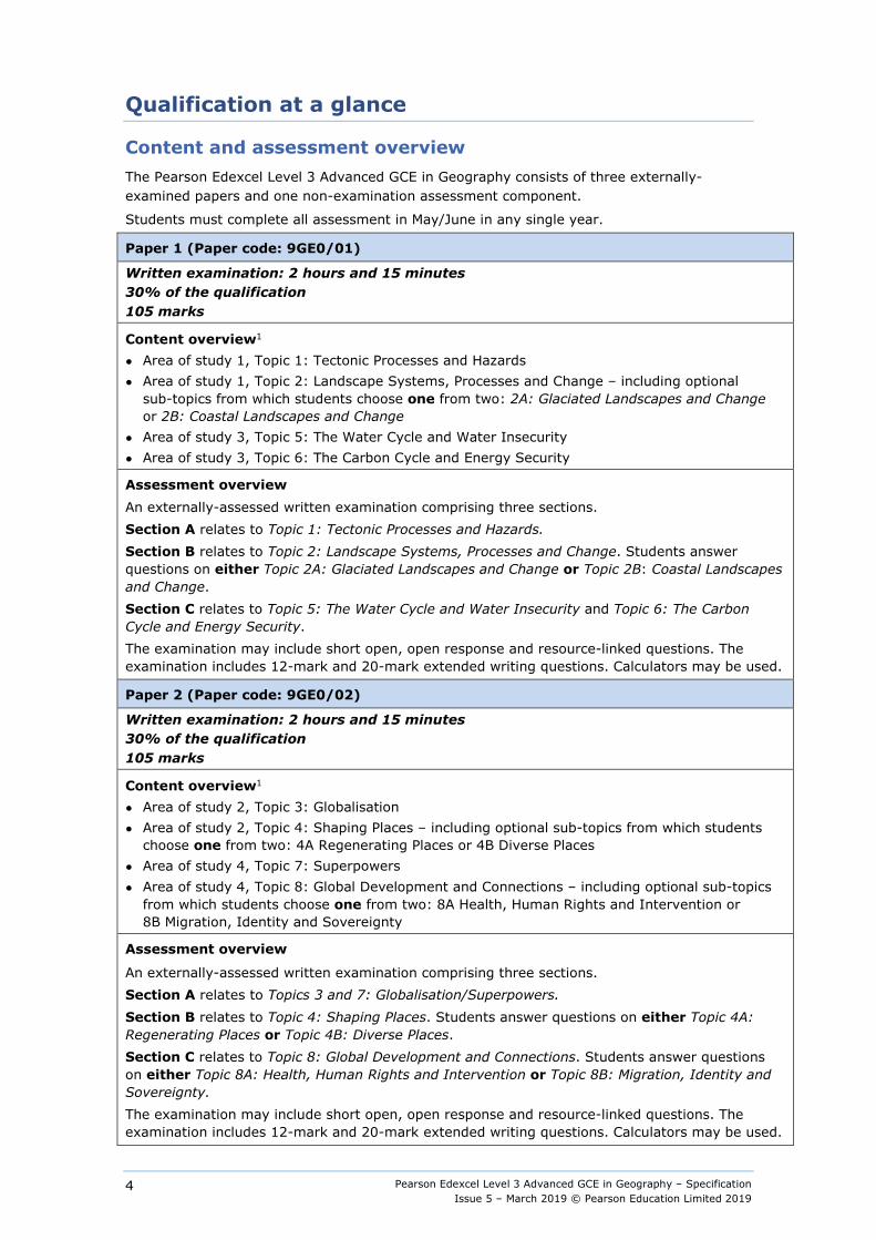
Qualification at a glance
Content and assessment overview The Pearson Edexcel Level 3 Advanced GCE in Geography consists of three externally-examined papers and one non-examination assessment component.
Students must complete all assessment in May/June in any single year.
Paper 1 (Paper code: 9GE0/01)
Written examination: 2 hours and 15 minutes 30% of the qualification 105 marks
Content overview1 ● Area of study 1, Topic 1: Tectonic Processes and Hazards ● Area of study 1, Topic 2: Landscape Systems, Processes and Change – including optional
sub-topics from which students choose one from two: 2A: Glaciated Landscapes and Change or 2B: Coastal Landscapes and Change
● Area of study 3, Topic 5: The Water Cycle and Water Insecurity ● Area of study 3, Topic 6: The Carbon Cycle and Energy Security
Assessment overview An externally-assessed written examination comprising three sections. Section A relates to Topic 1: Tectonic Processes and Hazards. Section B relates to Topic 2: Landscape Systems, Processes and Change. Students answer questions on either Topic 2A: Glaciated Landscapes and Change or Topic 2B: Coastal Landscapes and Change. Section C relates to Topic 5: The Water Cycle and Water Insecurity and Topic 6: The Carbon Cycle and Energy Security. The examination may include short open, open response and resource-linked questions. The examination includes 12-mark and 20-mark extended writing questions. Calculators may be used.
Paper 2 (Paper code: 9GE0/02)
Written examination: 2 hours and 15 minutes 30% of the qualification 105 marks
Content overview1 ● Area of study 2, Topic 3: Globalisation ● Area of study 2, Topic 4: Shaping Places – including optional sub-topics from which students
choose one from two: 4A Regenerating Places or 4B Diverse Places ● Area of study 4, Topic 7: Superpowers ● Area of study 4, Topic 8: Global Development and Connections – including optional sub-topics
from which students choose one from two: 8A Health, Human Rights and Intervention or 8B Migration, Identity and Sovereignty
Assessment overview
An externally-assessed written examination comprising three sections. Section A relates to Topics 3 and 7: Globalisation/Superpowers. Section B relates to Topic 4: Shaping Places. Students answer questions on either Topic 4A: Regenerating Places or Topic 4B: Diverse Places. Section C relates to Topic 8: Global Development and Connections. Students answer questions on either Topic 8A: Health, Human Rights and Intervention or Topic 8B: Migration, Identity and Sovereignty. The examination may include short open, open response and resource-linked questions. The examination includes 12-mark and 20-mark extended writing questions. Calculators may be used.
Pearson Edexcel Level 3 Advanced GCE in Geography – Specification Issue 5 – March 2019 © Pearson Education Limited 2019
5
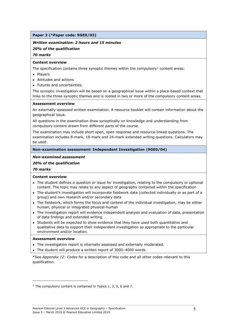
Paper 3 (*Paper code: 9GE0/03)
Written examination: 2 hours and 15 minutes
20% of the qualification
70 marks
Content overview
The specification contains three synoptic themes within the compulsory1 content areas: ● Players ● Attitudes and actions ● Futures and uncertainties.
The synoptic investigation will be based on a geographical issue within a place-based context that links to the three synoptic themes and is rooted in two or more of the compulsory content areas.
Assessment overview
An externally-assessed written examination. A resource booklet will contain information about the geographical issue.
All questions in the examination draw synoptically on knowledge and understanding from compulsory content drawn from different parts of the course.
The examination may include short open, open response and resource-linked questions. The examination includes 8-mark, 18-mark and 24-mark extended writing questions. Calculators may be used.
Non-examination assessment: Independent Investigation (9GE0/04)
Non-examined assessment
20% of the qualification
70 marks
Content overview ● The student defines a question or issue for investigation, relating to the compulsory or optional
content. The topic may relate to any aspect of geography contained within the specification ● The student’s investigation will incorporate fieldwork data (collected individually or as part of a
group) and own research and/or secondary data ● The fieldwork, which forms the focus and context of the individual investigation, may be either
human, physical or integrated physical-human ● The investigation report will evidence independent analysis and evaluation of data, presentation
of data findings and extended writing ● Students will be expected to show evidence that they have used both quantitative and
qualitative data to support their independent investigation as appropriate to the particular environment and/or location.
Assessment overview ● The investigation report is internally assessed and externally moderated. ● The student will produce a written report of 3000–4000 words.
*See Appendix 12: Codes for a description of this code and all other codes relevant to this qualification.
1 The compulsory content is contained in Topics 1, 3, 5, 6 and 7.
Pearson Edexcel Level 3 Advanced GCE in Geography – Specification Issue 5 – March 2019 © Pearson Education Limited 2019
6
2 Subject content and assessment information
The subject content sets out the knowledge, understanding and skills relevant to this qualification. Together with the assessment information, it provides the framework within which centres create their programmes of study, so ensuring progression from AS requirements and the possibilities for progression to higher education.
Qualification aims and objectives This specification for the discipline of geography encourages students to gain enjoyment, satisfaction and a sense of achievement as they develop their knowledge and understanding of the subject. This A Level course will enable students to be inspired by their geographical understanding, to engage critically with real world issues and places, and to apply their geographical knowledge, theory and skills to the world around them. Students will grow as independent thinkers and as informed and engaged citizens, who understand the role and importance of geography as one of the key disciplines relevant to understanding the world’s changing peoples, places and environments.
The aims and objectives of this qualification are to enable students to build on their AS knowledge and skills to: ● develop their knowledge of locations, places, processes and environments, at all
geographical scales from local to global across the specification as a whole ● develop an in-depth understanding of the selected core and non-core processes in physical
and human geography at a range of temporal and spatial scales, and of the concepts that illuminate their significance in a range of locational contexts
● recognise and be able to analyse the complexity of people–environment interactions at all geographical scales, and appreciate how they underpin understanding of some of the key issues facing the world today
● develop their understanding of, and ability to apply, the concepts of place, space, scale and environment, that underpin both the national curriculum and GCSE, including developing a more nuanced understanding of these concepts
● gain understanding of specialised concepts relevant to the core and non-core content. These must include the concepts of causality, systems, equilibrium, feedback, inequality, representation, identity, globalisation, interdependence, mitigation and adaptation, sustainability, risk, resilience and thresholds
● improve their understanding of the ways in which values, attitudes and circumstances have an impact on the relationships between people, place and environment, and develop the knowledge and ability to engage, as citizens, with the questions and issues arising (‘circumstances’ in this case refers to the context of people's lives, and the socio-economic and political milieu in which they find themselves)
● become confident and competent in selecting, using and evaluating a range of quantitative and qualitative skills and approaches, (including observing, collecting and analysing geo-located data) and applying them as an integral part of their studies
● understand the fundamental role of fieldwork as a tool to understand and generate new knowledge about the real world, and become skilled at planning, undertaking and evaluating fieldwork in appropriate situations
● apply geographical knowledge, understanding, skills and approaches in a rigorous way to a range of geographical questions and issues, including those identified in fieldwork, recognising both the contributions and limitations of geography
Pearson Edexcel Level 3 Advanced GCE in Geography – Specification Issue 5 – March 2019 © Pearson Education Limited 2019
7
● develop as critical and reflective learners, able to articulate opinions, suggest relevant new ideas and provide evidenced argument in a range of situations
● build on knowledge of contexts, locations, places and environments, by extending the scope and scale of study, the variety of physical, social, economic, cultural and political contexts encountered, the depth of conceptual understanding required, and the range of spatial and temporal scales included
● develop a deep understanding of both physical and human processes, applying this understanding to interrogate people–environment interactions and people–place connections at all scales from local to global
● build on and reinforce conceptual understanding underpinning GCSE, experiencing an extended demand that includes a wider range of more complex and specialised concepts that relate to the core and non-core content
● engage with models, theories and generalisations, and develop a mature understanding of the nature and limitations of objectivity and the significance of human values and attitudes
● develop understanding of the rationale for, and applications of, skills and approaches used, showing a considerable degree of independence in selecting and using a wide range of geographical methods, techniques and skills, involving both qualitative and quantitative methods
● undertake fieldwork that encourages them to apply and evaluate theory in the real world, and that A Level fieldwork in particular demands a high degree of responsibility from students for selecting research questions, applying relevant techniques and skills, and identifying appropriate ways of analysing and communicating findings.
Geographical skills This qualification requires students to evidence a variety of geographical skills, showing a critical awareness of the appropriateness and limitations of different methods, skills and techniques.
Full details of the required geographical skills are given in Appendix 1: Geographical skills.
Fieldwork A Level students must complete a minimum of four days of fieldwork. Fieldwork must be carried out in relation to processes in physical and human geography. This is a Department for Education (DfE) requirement. Centres will be required to provide evidence of this fieldwork in the form of a written fieldwork statement. The fieldwork statement represents a true and accurate written declaration made by a centre to Pearson, confirming that a student to which that centre has delivered the A Level Geography assessment has undertaken geographical fieldwork over four days and in both physical and human environments. Pearson will publish the final deadline date for submission of this form on our website. Failure to return the Fieldwork Statement on time will constitute malpractice on the part of the Centre, see page 86.
In the non-examination assessment component, students are required to undertake an independent investigation that involves (but need not be restricted to) fieldwork, producing a written report. Students’ investigations will incorporate fieldwork data (collected individually or as part of a group).
Full details of the required fieldwork skills are provided in Appendix 2: Fieldwork skills.

Pearson Edexcel Level 3 Advanced GCE in Geography – Specification Issue 5 – March 2019 © Pearson Education Limited 2019
8
How to use the content section of the specification
Overview Each topic begins with an overview. This provides an explanation of the relevance of the topic to modern geography. It also outlines links between the topic and other areas of the specification. The overview does not form part of the assessed content, but could be used by teachers when introducing a new topic to students.
Enquiry questions Each topic contains three or four enquiry questions. The enquiry questions should form the basis for the study of that topic. Enquiry questions encourage active learning and an investigative, critically evaluative approach. An enquiry question, combined with the key ideas in the left-hand column of the specification content, can be used as the starting point to develop learning objectives for one or more lessons.
Guidance for integrating geographical skills This qualification requires students to evidence a variety of geographical skills, showing a critical awareness of the appropriateness and limitations of different methods, skills and techniques.
Guidance on integrating these skills has been provided at the end of each content topic under the heading Guidance for integrating geographical skills. This guidance provides suggested opportunities for integrating the full range of skills outlined in the geographical skills appendix. Opportunities to integrate geographical skills are indicated by bracketed numbers in the detailed content, (1) for example. These skills are not exclusive to the topic areas under which they appear; students will need to be able to apply these skills across any suitable topic area throughout their course of study.
Full details of the required geographical skills are provided in Appendix 1: Geographical skills.
Pearson Edexcel Level 3 Advanced GCE in Geography – Specification Issue 5 – March 2019 © Pearson Education Limited 2019
9
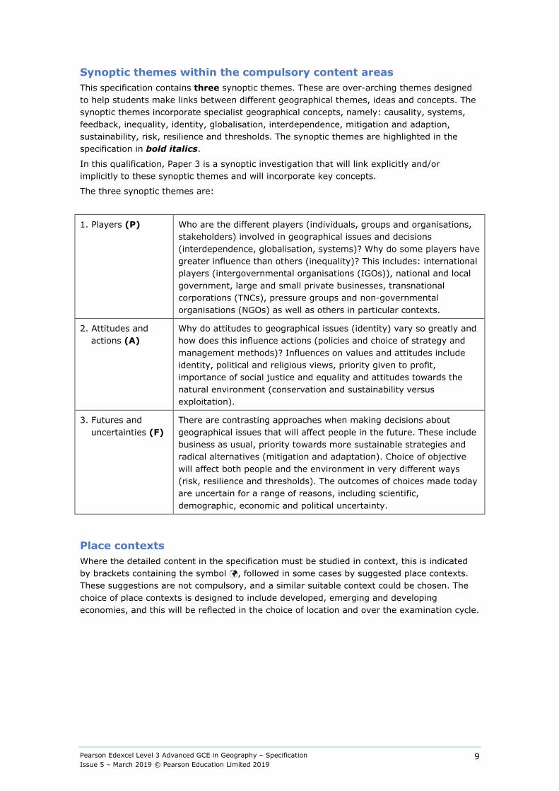
Synoptic themes within the compulsory content areas This specification contains three synoptic themes. These are over-arching themes designed to help students make links between different geographical themes, ideas and concepts. The synoptic themes incorporate specialist geographical concepts, namely: causality, systems, feedback, inequality, identity, globalisation, interdependence, mitigation and adaption, sustainability, risk, resilience and thresholds. The synoptic themes are highlighted in the specification in bold italics.
In this qualification, Paper 3 is a synoptic investigation that will link explicitly and/or implicitly to these synoptic themes and will incorporate key concepts.
The three synoptic themes are:
1. Players (P) Who are the different players (individuals, groups and organisations, stakeholders) involved in geographical issues and decisions (interdependence, globalisation, systems)? Why do some players have greater influence than others (inequality)? This includes: international players (intergovernmental organisations (IGOs)), national and local government, large and small private businesses, transnational corporations (TNCs), pressure groups and non-governmental organisations (NGOs) as well as others in particular contexts.
2. Attitudes and actions (A)
Why do attitudes to geographical issues (identity) vary so greatly and how does this influence actions (policies and choice of strategy and management methods)? Influences on values and attitudes include identity, political and religious views, priority given to profit, importance of social justice and equality and attitudes towards the natural environment (conservation and sustainability versus exploitation).
3. Futures and uncertainties (F)
There are contrasting approaches when making decisions about geographical issues that will affect people in the future. These include business as usual, priority towards more sustainable strategies and radical alternatives (mitigation and adaptation). Choice of objective will affect both people and the environment in very different ways (risk, resilience and thresholds). The outcomes of choices made today are uncertain for a range of reasons, including scientific, demographic, economic and political uncertainty.
Place contexts Where the detailed content in the specification must be studied in context, this is indicated by brackets containing the symbol , followed in some cases by suggested place contexts. These suggestions are not compulsory, and a similar suitable context could be chosen. The choice of place contexts is designed to include developed, emerging and developing economies, and this will be reflected in the choice of location and over the examination cycle.
Pearson Edexcel Level 3 Advanced GCE in Geography – Specification Issue 5 – March 2019 © Pearson Education Limited 2019
10
Area of study 1: Dynamic Landscapes
Topic 1: Tectonic Processes and Hazards
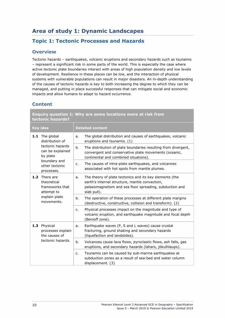
Overview Tectonic hazards – earthquakes, volcanic eruptions and secondary hazards such as tsunamis – represent a significant risk in some parts of the world. This is especially the case where active tectonic plate boundaries interact with areas of high population density and low levels of development. Resilience in these places can be low, and the interaction of physical systems with vulnerable populations can result in major disasters. An in-depth understanding of the causes of tectonic hazards is key to both increasing the degree to which they can be managed, and putting in place successful responses that can mitigate social and economic impacts and allow humans to adapt to hazard occurrence.
Content
Enquiry question 1: Why are some locations more at risk from tectonic hazards?
Key idea Detailed content
1.1 The global distribution of tectonic hazards can be explained by plate boundary and other tectonic processes.
a. The global distribution and causes of earthquakes, volcanic eruptions and tsunamis. (1)
b. The distribution of plate boundaries resulting from divergent, convergent and conservative plate movements (oceanic, continental and combined situations).
c. The causes of intra-plate earthquakes, and volcanoes associated with hot spots from mantle plumes.
1.2 There are theoretical frameworks that attempt to explain plate movements.
a. The theory of plate tectonics and its key elements (the earth’s internal structure, mantle convection, palaeomagnetism and sea floor spreading, subduction and slab pull).
b. The operation of these processes at different plate margins (destructive, constructive, collision and transform). (2)
c. Physical processes impact on the magnitude and type of volcanic eruption, and earthquake magnitude and focal depth (Benioff zone).
1.3 Physical processes explain the causes of tectonic hazards.
a. Earthquake waves (P, S and L waves) cause crustal fracturing, ground shaking and secondary hazards (liquefaction and landslides).
b. Volcanoes cause lava flows, pyroclastic flows, ash falls, gas eruptions, and secondary hazards (lahars, jökulhlaups).
c. Tsunamis can be caused by sub-marine earthquakes at subduction zones as a result of sea-bed and water column displacement. (3)
Pearson Edexcel Level 3 Advanced GCE in Geography – Specification Issue 5 – March 2019 © Pearson Education Limited 2019
11
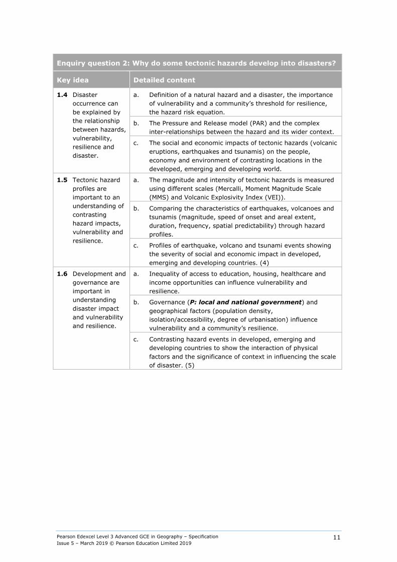
Enquiry question 2: Why do some tectonic hazards develop into disasters?
Key idea Detailed content
1.4 Disaster occurrence can be explained by the relationship between hazards, vulnerability, resilience and disaster.
a. Definition of a natural hazard and a disaster, the importance of vulnerability and a community’s threshold for resilience, the hazard risk equation.
b. The Pressure and Release model (PAR) and the complex inter-relationships between the hazard and its wider context.
c. The social and economic impacts of tectonic hazards (volcanic eruptions, earthquakes and tsunamis) on the people, economy and environment of contrasting locations in the developed, emerging and developing world.
1.5 Tectonic hazard profiles are important to an understanding of contrasting hazard impacts, vulnerability and resilience.
a. The magnitude and intensity of tectonic hazards is measured using different scales (Mercalli, Moment Magnitude Scale (MMS) and Volcanic Explosivity Index (VEI)).
b. Comparing the characteristics of earthquakes, volcanoes and tsunamis (magnitude, speed of onset and areal extent, duration, frequency, spatial predictability) through hazard profiles.
c. Profiles of earthquake, volcano and tsunami events showing the severity of social and economic impact in developed, emerging and developing countries. (4)
1.6 Development and governance are important in understanding disaster impact and vulnerability and resilience.
a. Inequality of access to education, housing, healthcare and income opportunities can influence vulnerability and resilience.
b. Governance (P: local and national government) and geographical factors (population density, isolation/accessibility, degree of urbanisation) influence vulnerability and a community’s resilience.
c. Contrasting hazard events in developed, emerging and developing countries to show the interaction of physical factors and the significance of context in influencing the scale of disaster. (5)
Pearson Edexcel Level 3 Advanced GCE in Geography – Specification Issue 5 – March 2019 © Pearson Education Limited 2019
12
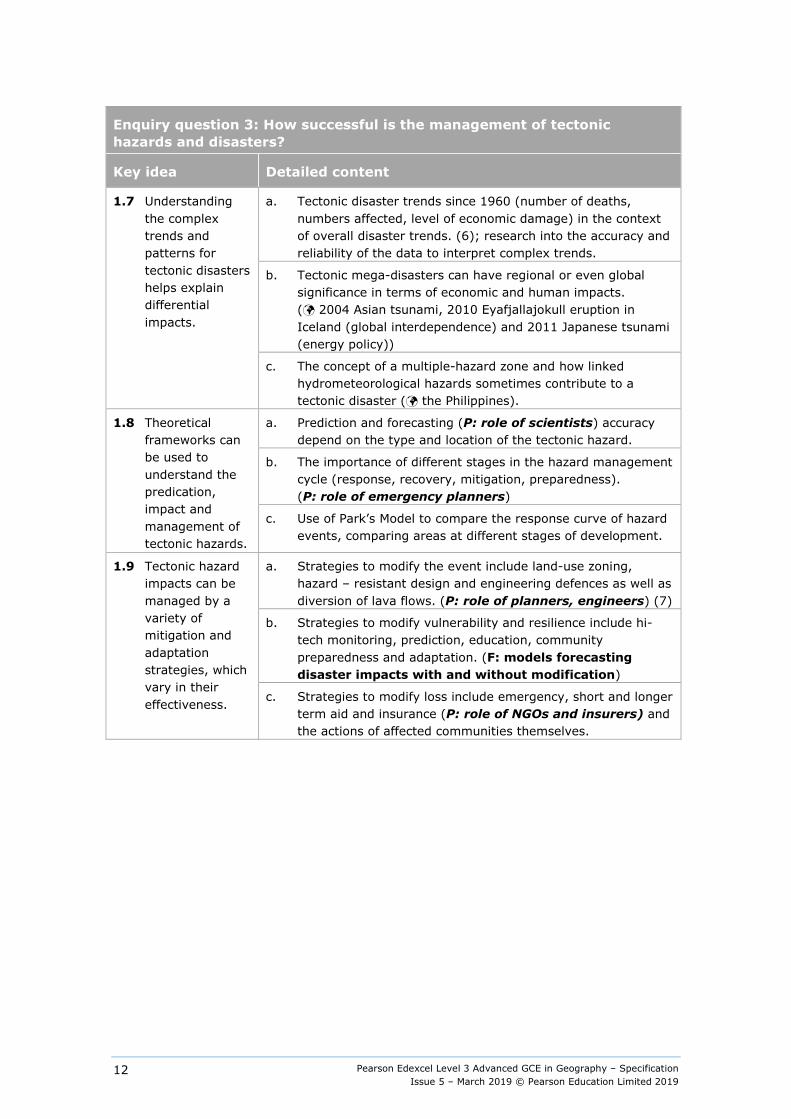
Enquiry question 3: How successful is the management of tectonic hazards and disasters?
Key idea Detailed content
1.7 Understanding the complex trends and patterns for tectonic disasters helps explain differential impacts.
a. Tectonic disaster trends since 1960 (number of deaths, numbers affected, level of economic damage) in the context of overall disaster trends. (6); research into the accuracy and reliability of the data to interpret complex trends.
b. Tectonic mega-disasters can have regional or even global significance in terms of economic and human impacts. ( 2004 Asian tsunami, 2010 Eyafjallajokull eruption in Iceland (global interdependence) and 2011 Japanese tsunami (energy policy))
c. The concept of a multiple-hazard zone and how linked hydrometeorological hazards sometimes contribute to a tectonic disaster ( the Philippines).
1.8 Theoretical frameworks can be used to understand the predication, impact and management of tectonic hazards.
a. Prediction and forecasting (P: role of scientists) accuracy depend on the type and location of the tectonic hazard.
b. The importance of different stages in the hazard management cycle (response, recovery, mitigation, preparedness). (P: role of emergency planners)
c. Use of Park’s Model to compare the response curve of hazard events, comparing areas at different stages of development.
1.9 Tectonic hazard impacts can be managed by a variety of mitigation and adaptation strategies, which vary in their effectiveness.
a. Strategies to modify the event include land-use zoning, hazard – resistant design and engineering defences as well as diversion of lava flows. (P: role of planners, engineers) (7)
b. Strategies to modify vulnerability and resilience include hi-tech monitoring, prediction, education, community preparedness and adaptation. (F: models forecasting disaster impacts with and without modification)
c. Strategies to modify loss include emergency, short and longer term aid and insurance (P: role of NGOs and insurers) and the actions of affected communities themselves.
Pearson Edexcel Level 3 Advanced GCE in Geography – Specification Issue 5 – March 2019 © Pearson Education Limited 2019
13
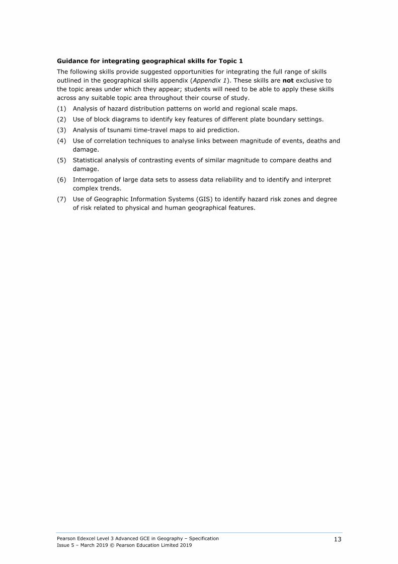
Guidance for integrating geographical skills for Topic 1
The following skills provide suggested opportunities for integrating the full range of skills outlined in the geographical skills appendix (Appendix 1). These skills are not exclusive to the topic areas under which they appear; students will need to be able to apply these skills across any suitable topic area throughout their course of study.
(1) Analysis of hazard distribution patterns on world and regional scale maps.
(2) Use of block diagrams to identify key features of different plate boundary settings.
(3) Analysis of tsunami time-travel maps to aid prediction.
(4) Use of correlation techniques to analyse links between magnitude of events, deaths and damage.
(5) Statistical analysis of contrasting events of similar magnitude to compare deaths and damage.
(6) Interrogation of large data sets to assess data reliability and to identify and interpret complex trends.
(7) Use of Geographic Information Systems (GIS) to identify hazard risk zones and degree of risk related to physical and human geographical features.

Pearson Edexcel Level 3 Advanced GCE in Geography – Specification Issue 5 – March 2019 © Pearson Education Limited 2019
14
Topic 2: Landscape Systems, Processes and Change
Option 2A: Glaciated Landscapes and Change
Overview Ice sheets and glaciers operate within a landscape system as glacial processes of erosion, transport and deposition combine with meteorological and climatological processes and interact with geological and lithological processes to produce distinctive landscapes. The landscapes can be both present day and relict and can occur in both upland and lowland areas. These landscapes are being changed by both physical processes and human activities which pose unique threats due to the low level of resilience found in these areas. Study must include examples of landscapes from areas inside and outside the UK.
Content
Enquiry question 1: How has climate change influenced the formation of glaciated landscapes over time?
Key idea Detailed content
2A.1 The causes of longer and shorter climate change, which have led to icehouse- greenhouse changes.
a. A chronology of multiple glacial and interglacial periods caused by Pleistocene climate change.
b. The long-term factors leading to climate change: Milankovitch cycles as the primary driver and the shorter-term role of variations in solar output (1), and volcanic eruptions.
c. The characteristics and causes of shorter-term climate events: Loch Lomond Stadial (Pleistocene) and the Little Ice Age (Holocene).
2A.2 Present and past Pleistocene distribution of ice cover.
a. The definition and importance of the cryosphere and its role in global systems and classification of ice masses by scale and location (ice sheets, ice caps, cirque and valley glaciers, and ice fields) and polar and temperate environments.
b. The present-day distribution of high latitude ice sheets and evidence for Pleistocene ice sheet extent.
c. The present-day distribution of high altitude glaciated upland landscapes and evidence of relict landscapes from the Pleistocene. (2)
2A.3 Periglacial processes produce distinctive landscapes.
a. Distribution of past and present periglacial landscapes which are underlain by continuous, discontinuous and sporadic areas of permafrost with a seasonally active layer.
b. Periglacial processes include nivation, frost heave, freeze-thaw weathering and solifluction as well as high winds and meltwater erosion.
c. The formation of often unique periglacial landforms (ice wedges, patterned ground, pingos, loess) contributes towards the occurrence of distinctive periglacial landscapes ( Tundra environments of northern Russia or northern Canada).
Pearson Edexcel Level 3 Advanced GCE in Geography – Specification Issue 5 – March 2019 © Pearson Education Limited 2019
15
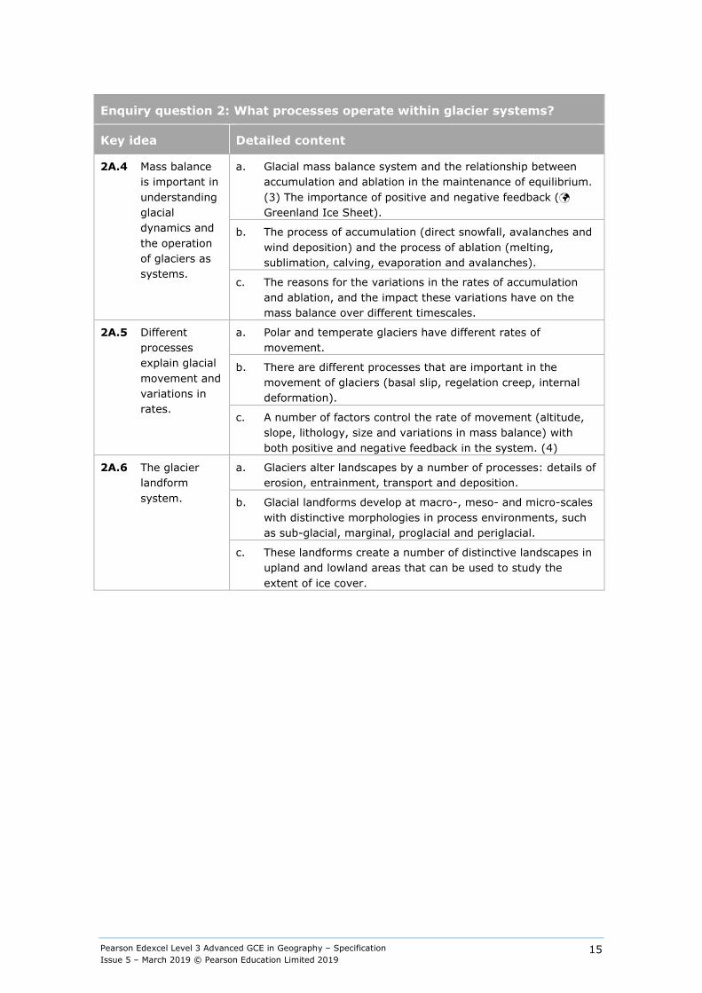
Enquiry question 2: What processes operate within glacier systems?
Key idea Detailed content
2A.4 Mass balance is important in understanding glacial dynamics and the operation of glaciers as systems.
a. Glacial mass balance system and the relationship between accumulation and ablation in the maintenance of equilibrium. (3) The importance of positive and negative feedback ( Greenland Ice Sheet).
b. The process of accumulation (direct snowfall, avalanches and wind deposition) and the process of ablation (melting, sublimation, calving, evaporation and avalanches).
c. The reasons for the variations in the rates of accumulation and ablation, and the impact these variations have on the mass balance over different timescales.
2A.5 Different processes explain glacial movement and variations in rates.
a. Polar and temperate glaciers have different rates of movement.
b. There are different processes that are important in the movement of glaciers (basal slip, regelation creep, internal deformation).
c. A number of factors control the rate of movement (altitude, slope, lithology, size and variations in mass balance) with both positive and negative feedback in the system. (4)
2A.6 The glacier landform system.
a. Glaciers alter landscapes by a number of processes: details of erosion, entrainment, transport and deposition.
b. Glacial landforms develop at macro-, meso- and micro-scales with distinctive morphologies in process environments, such as sub-glacial, marginal, proglacial and periglacial.
c. These landforms create a number of distinctive landscapes in upland and lowland areas that can be used to study the extent of ice cover.

Pearson Edexcel Level 3 Advanced GCE in Geography – Specification Issue 5 – March 2019 © Pearson Education Limited 2019
16
Enquiry question 3: How do glacial processes contribute to the formation of glacial landforms and landscapes?
Key idea Detailed content
2A.7 Glacial erosion creates distinctive landforms and contributes to glaciated landscapes.
a. Glacial erosional processes (abrasion, quarrying, plucking, crushing and basal melting, combined with subaerial freeze thaw and mass movement).
b. The processes leading to the formation of landforms associated with cirque and valley glaciers (cirques/corries (5), arêtes, pyramidal peaks, glacial troughs, truncated spurs/hanging valleys and ribbon lakes).
c. The formation of landforms due to ice sheet scouring (roches moutonnées, knock and lochan, crag and tail) and the influence of differential geology.
2A.8 Glacial deposition creates distinctive landforms and contributes to glaciated landscapes.
a. The formation of glacial (ice contact) depositional features (medial, lateral, recessional and terminal moraines and drumlins).
b. The formation of lowland depositional features (till plains, lodgement and ablation till). (6)
c. The assemblage of landforms can be used to reconstruct former ice extent, movement and provenance (erratics, moraines, crag and tail, drumlin orientation). (7)
2A.9 Glacial meltwater plays a significant role in creating distinctive landforms and contributes to glaciated landscapes.
a. The processes of water movement within the glacial system (supraglacial, englacial and sub-glacial flows).
b. Glacial and fluvioglacial deposits have different characteristics (stratification, sorting, imbrication and grading). (8)
c. The formation of fluvio-glacial landforms; ice contact features (kames, eskers and kame terraces) and proglacial features (sandurs, pro-glacial lakes, meltwater channels, and kettleholes).

Pearson Edexcel Level 3 Advanced GCE in Geography – Specification Issue 5 – March 2019 © Pearson Education Limited 2019
17
Enquiry question 4: How are glaciated landscapes used and managed today?
Key idea Detailed content
2A.10 Glacial and periglacial landscapes have intrinsic cultural, economic and environmental value.
a. Relict and active glaciated landscapes have environmental and cultural value (polar scientific research, wilderness recreation, and spiritual/religious associations). (A: attitudes range from exploitation to preservation)
b. Glaciated landscapes are important economically (farming, mining, hydroelectric power, tourism, forestry) to include a study of contrasting environments around the world.
c. Glaciated and periglacial landscapes have a unique biodiversity (tundra) and play an important role in the maintenance of natural systems (water and carbon cycles).
2A.11 There are threats facing fragile active and relict glaciated upland landscapes.
a. Glaciated landscapes face varying degrees of threat from both natural hazards (avalanches and glacial outburst floods) and human activities (leisure and tourism, reservoir construction, urbanisation) ( Alpine Valleys).
b. Human activity can degrade the landscape and fragile ecology of glaciated landscapes (soil erosion, trampling, landslides, deforestation). (A: direct actions by players reduce resilience)
c. Global warming is having a major impact on glacial mass balances, which in turn risks disruption of the hydrological cycle (meltwater, river discharge, sediment yield, water quality) ( Himalayan Glaciers). (9) (A: indirect actions by players alter natural systems)
2A.12 Threats to glaciated landscapes can be managed using a spectrum of approaches.
a. Different stakeholders (conservationists, local and regional government, global organisations, NGOs) are involved in managing the challenges posed by glaciated landscapes, using a spectrum of approaches from protection through to sustainable management and multiple economic use ( Yosemite Valley). (A: actions range from exploitation to preservation)
b. Legislative frameworks are used to protect and conserve landscapes by conservation and management at a variety of scales.
c. Climate warming is a context risk, meaning that successful management of these unique and fragile landscapes is increasingly challenging, with a need for coordinated approaches at global, national and local scale. (F: this risk is creating an uncertain future and needs mitigation and adaptation)
Pearson Edexcel Level 3 Advanced GCE in Geography – Specification Issue 5 – March 2019 © Pearson Education Limited 2019
18
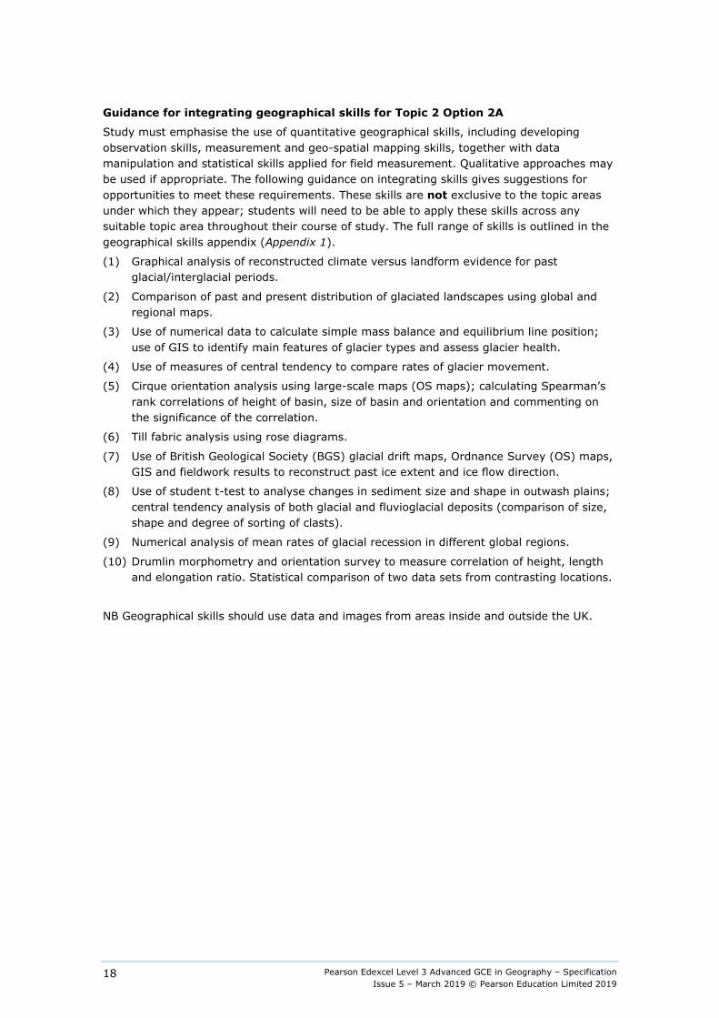
Guidance for integrating geographical skills for Topic 2 Option 2A
Study must emphasise the use of quantitative geographical skills, including developing observation skills, measurement and geo-spatial mapping skills, together with data manipulation and statistical skills applied for field measurement. Qualitative approaches may be used if appropriate. The following guidance on integrating skills gives suggestions for opportunities to meet these requirements. These skills are not exclusive to the topic areas under which they appear; students will need to be able to apply these skills across any suitable topic area throughout their course of study. The full range of skills is outlined in the geographical skills appendix (Appendix 1).
(1) Graphical analysis of reconstructed climate versus landform evidence for past glacial/interglacial periods.
(2) Comparison of past and present distribution of glaciated landscapes using global and regional maps.
(3) Use of numerical data to calculate simple mass balance and equilibrium line position; use of GIS to identify main features of glacier types and assess glacier health.
(4) Use of measures of central tendency to compare rates of glacier movement.
(5) Cirque orientation analysis using large-scale maps (OS maps); calculating Spearman’s rank correlations of height of basin, size of basin and orientation and commenting on the significance of the correlation.
(6) Till fabric analysis using rose diagrams.
(7) Use of British Geological Society (BGS) glacial drift maps, Ordnance Survey (OS) maps, GIS and fieldwork results to reconstruct past ice extent and ice flow direction.
(8) Use of student t-test to analyse changes in sediment size and shape in outwash plains; central tendency analysis of both glacial and fluvioglacial deposits (comparison of size, shape and degree of sorting of clasts).
(9) Numerical analysis of mean rates of glacial recession in different global regions.
(10) Drumlin morphometry and orientation survey to measure correlation of height, length and elongation ratio. Statistical comparison of two data sets from contrasting locations.
NB Geographical skills should use data and images from areas inside and outside the UK.

Pearson Edexcel Level 3 Advanced GCE in Geography – Specification Issue 5 – March 2019 © Pearson Education Limited 2019
19
Topic 2: Landscape Systems, Processes and Change
Option 2B: Coastal Landscapes and Change
Overview Coastal landscapes develop due to the interaction of winds, waves and currents, as well as through the contribution of both terrestrial and offshore sources of sediment. These flows of energy and variations in sediment budgets interact with the prevailing geological and lithological characteristics of the coast to operate as coastal systems and produce distinctive coastal landscapes, including those in rocky, sandy and estuarine coastlines. These landscapes are increasingly threatened from physical processes and human activities, and there is a need for holistic and sustainable management of these areas in all the world’s coasts. Study must include examples of landscapes from inside and outside the UK.
Content
Enquiry question 1: Why are coastal landscapes different and what processes cause these differences?
Key idea Detailed content
2B.1 The coast, and wider littoral zone, has distinctive features and landscapes.
a. The littoral zone consists of backshore, nearshore and offshore zones, includes a wide variety of coastal types and is a dynamic zone of rapid change.
b. Coasts can be classified by using longer term criteria such as geology and changes of sea level or shorter term processes such as inputs from rivers, waves and tides.
c. Rocky coasts (high and low relief) result from resistant geology (withstands erosive forces of sea, rain and wind), often in a high-energy environment, whereas coastal plain landscapes (sandy and estuarine coasts) are found near areas of low relief and result from supply of sediment from different terrestrial and offshore sources, often in a low-energy environment.
2B.2 Geological structure influences the development of coastal landscapes at a variety of scales.
a. Geological structure is responsible for the formation of concordant and discordant coasts.
b. Geological structure influences coastal morphology: Dalmatian and Haff type concordant coasts and headlands and bays on discordant coasts.
c. Geological structure (jointing, dip, faulting, folding) is an important influence on coastal morphology and erosion rates, and also on the formation of cliff profiles and the occurrence of micro-features, e.g. caves ( Glamorgan Heritage Coast). (2)
2B.3 Rates of coastal recession and stability depend on lithology and other factors.
a. Bedrock lithology (igneous, sedimentary, metamorphic) and unconsolidated material (boulder clay) geology are important in understanding rates of coastal recession.
b. Differential erosion of alternating strata in cliffs (permeable/impermeable, resistant/less resistant) produces complex cliff profiles and influences recession rates. (3)
c. Vegetation is important in stabilising sandy coastlines through dune successional development and salt marsh successional development in estuarine areas.
Pearson Edexcel Level 3 Advanced GCE in Geography – Specification Issue 5 – March 2019 © Pearson Education Limited 2019
20
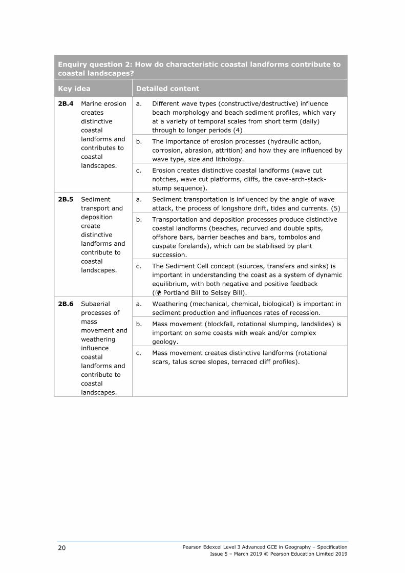
Enquiry question 2: How do characteristic coastal landforms contribute to coastal landscapes?
Key idea Detailed content
2B.4 Marine erosion creates distinctive coastal landforms and contributes to coastal landscapes.
a. Different wave types (constructive/destructive) influence beach morphology and beach sediment profiles, which vary at a variety of temporal scales from short term (daily) through to longer periods (4)
b. The importance of erosion processes (hydraulic action, corrosion, abrasion, attrition) and how they are influenced by wave type, size and lithology.
c. Erosion creates distinctive coastal landforms (wave cut notches, wave cut platforms, cliffs, the cave-arch-stack-stump sequence).
2B.5 Sediment transport and deposition create distinctive landforms and contribute to coastal landscapes.
a. Sediment transportation is influenced by the angle of wave attack, the process of longshore drift, tides and currents. (5)
b. Transportation and deposition processes produce distinctive coastal landforms (beaches, recurved and double spits, offshore bars, barrier beaches and bars, tombolos and cuspate forelands), which can be stabilised by plant succession.
c. The Sediment Cell concept (sources, transfers and sinks) is important in understanding the coast as a system of dynamic equilibrium, with both negative and positive feedback ( Portland Bill to Selsey Bill).
2B.6 Subaerial processes of mass movement and weathering influence coastal landforms and contribute to coastal landscapes.
a. Weathering (mechanical, chemical, biological) is important in sediment production and influences rates of recession.
b. Mass movement (blockfall, rotational slumping, landslides) is important on some coasts with weak and/or complex geology.
c. Mass movement creates distinctive landforms (rotational scars, talus scree slopes, terraced cliff profiles).
Pearson Edexcel Level 3 Advanced GCE in Geography – Specification Issue 5 – March 2019 © Pearson Education Limited 2019
21
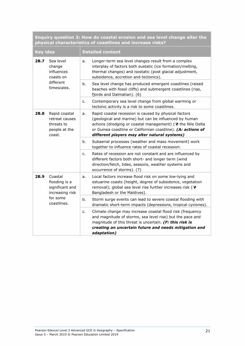
Enquiry question 3: How do coastal erosion and sea level change alter the physical characteristics of coastlines and increase risks?
Key idea Detailed content
2B.7 Sea level change influences coasts on different timescales.
a. Longer-term sea level changes result from a complex interplay of factors both eustatic (ice formation/melting, thermal changes) and isostatic (post glacial adjustment, subsidence, accretion and tectonics).
b. Sea level change has produced emergent coastlines (raised beaches with fossil cliffs) and submergent coastlines (rias, fjords and Dalmatian). (6)
c. Contemporary sea level change from global warming or tectonic activity is a risk to some coastlines.
2B.8 Rapid coastal retreat causes threats to people at the coast.
a. Rapid coastal recession is caused by physical factors (geological and marine) but can be influenced by human actions (dredging or coastal management) ( the Nile Delta or Guinea coastline or Californian coastline). (A: actions of different players may alter natural systems)
b. Subaerial processes (weather and mass movement) work together to influence rates of coastal recession.
c. Rates of recession are not constant and are influenced by different factors both short- and longer term (wind direction/fetch, tides, seasons, weather systems and occurrence of storms). (7)
2B.9 Coastal flooding is a significant and increasing risk for some coastlines.
a. Local factors increase flood risk on some low-lying and estuarine coasts (height, degree of subsidence, vegetation removal); global sea level rise further increases risk ( Bangladesh or the Maldives).
b. Storm surge events can lead to severe coastal flooding with dramatic short-term impacts (depressions, tropical cyclones).
c. Climate change may increase coastal flood risk (frequency and magnitude of storms, sea level rise) but the pace and magnitude of this threat is uncertain. (F: this risk is creating an uncertain future and needs mitigation and adaptation)
Pearson Edexcel Level 3 Advanced GCE in Geography – Specification Issue 5 – March 2019 © Pearson Education Limited 2019
22
Enquiry question 4: How can coastlines be managed to meet the needs of all players?
Key idea Detailed content
2B.10 Increasing risks of coastal recession and coastal flooding have serious consequences for affected communities.
a. Economic losses (housing, businesses, agricultural land, infrastructure) and social losses (relocation, loss of livelihood, amenity value) from coastal recession can be significant, especially in areas of dense coastal developments.
b. Coastal flooding and storm surge events can have serious economic and social consequences for coastal communities in both developing and developed countries.
c. Climate change may create environmental refugees in coastal areas.
2B.11 There are different approaches to managing the risks associated with coastal recession and flooding.
a. Hard engineering approaches (groynes, sea walls, rip rap, revetments, offshore breakwaters) are economically costly and directly alter physical processes and systems. (8) (A: actions by different players may have unforeseen consequences)
b. Soft engineering approaches (beach nourishment, cliff re-grading and drainage, dune stabilisation) attempt to work with physical systems and processes to protect coasts and manage risks caused by changes in sea-level. (9)
c. Sustainable management is designed to cope with future threats (increased storm events, rising sea levels) but its implementation can lead to local conflicts in many countries. (F: mitigation and adaptation will both be needed for future stability)
2B.12 Coastlines are now increasingly managed by holistic integrated coastal zone management (ICZM).
a. Coastal management increasingly uses the concept of littoral cells to manage extended areas of coastline. Throughout the world, countries are developing schemes that are sustainable and use holistic ICZM strategies.
b. Shoreline Management Policy decisions (No Active Intervention, Strategic Realignment, Hold The Line, Advance The Line) are based on complex judgements (engineering feasibility, environmental sensitivity, land value, political and social reasons); Cost Benefit Analysis (CBA) and Environmental Impact Assessment (EIA) are used as part of the decision-making process.
c. Policy decisions can lead to conflicts between different players (homeowners, local authorities, environmental pressure groups) with perceived winners and losers in countries at different levels of development (developed and developing or emerging countries) ( Happisburgh and Chittagong). (A: attitudes of differing players may vary)
Pearson Edexcel Level 3 Advanced GCE in Geography – Specification Issue 5 – March 2019 © Pearson Education Limited 2019
23
Guidance for integrating geographical skills for Topic 2 Option 2B
Study must emphasise the use of quantitative geographical skills, including developing observation skills, measurement and geo-spatial mapping skills, together with data manipulation and statistical skills applied for field measurement. Qualitative approaches may be used if appropriate. The following guidance on integrating skills gives suggestions of opportunities to meet these requirements. These skills are not exclusive to the topic areas under which they appear; students will need to be able to apply these skills across any suitable topic area throughout their course of study. The full range of skills is outlined in the geographical skills appendix (Appendix 1).
(1) GIS mapping of the variety of coastal landscapes, both for and beyond the UK.
(2) Satellite interpretation of a variety of coastlines to attempt to classify them.
(3) Field sketches of contrasting coastal landscapes.
(4) Using measures of central tendency to classify waves into destructive and constructive wave types.
(5) Using student t-test to investigate changes in pebble size and shape along a drift aligned beach and also across the littoral zone to above the storm beach.
(6) Map and aerial interpretation of distinctive landforms indicating past of sea level change.
(7) Use of GIS, aerial photos and maps to calculate recession rates for a variety of temporal rates (annual changes and longer-term changes).
(8) Interrogation of GIS of management cells to ascertain land use values and develop cost/benefit analysis to inform the choice of coastal management strategy.
(9) Photo interpretation of a range of approaches to management to assess environmental impact.
(10) Sand dune or salt marsh surveys to assess the impact of succession using an index of diversity, X² (Chi-square to compare features of the various zones).
Pearson Edexcel Level 3 Advanced GCE in Geography – Specification Issue 5 – March 2019 © Pearson Education Limited 2019
24
Area of study 2: Dynamic Places
Topic 3: Globalisation
Overview Globalisation and global interdependence continue to accelerate, resulting in changing opportunities for businesses and people. Inequalities are caused within and between countries as shifts in patterns of wealth occur. Cultural impacts on the identity of communities increase as flows of ideas, people and goods take place. Recognising that both tensions in communities and pressures on environments are likely, will help players implement sustainable solutions.
Content
Enquiry question 1: What are the causes of globalisation and why has it accelerated in recent decades?
Key idea Detailed content
3.1 Globalisation is a long-standing process which has accelerated because of rapid developments in transport, communications and businesses.
a. Globalisation involves widening and deepening global connections, interdependence and flows (commodities, capital, information, migrants and tourists). (1)
b. Developments in transport and trade in the 19th century (railways, telegraph, steam-ships) accelerated in the 20th century (jet aircraft, containerisation), contributing to a ‘shrinking world’.
c. The 21st century has been dominated by rapid development in ICT and global communication (mobile phones, internet, social networking, electronic banking, fibre optics), lowering communication costs and contributing to time-space compression.
3.2 Political and economic decision making are important factors in the acceleration of globalisation.
a. International political and economic organisations (P: role of World Trade Organization (WTO), International Monetary Fund (IMF), World Bank) have contributed to globalisation through the promotion of free trade policies and foreign direct investment (FDI).
b. National governments are key players in terms of promoting free trade blocs (P: role of European Union (EU), The Association of Southeast Asian Nations (ASEAN)) and through polices (free-market liberalisation, privatisation, encouraging business start-ups). (P: role of governments in economic liberalisation)
c. Special economic zones, government subsidies and attitudes to FDI ( China’s 1978 Open Door Policy) have contributed to the spread of globalisation into new global regions (P: role of governments in attracting foreign direct investment (FDI))
Pearson Edexcel Level 3 Advanced GCE in Geography – Specification Issue 5 – March 2019 © Pearson Education Limited 2019
25
Enquiry question 1: What are the causes of globalisation and why has it accelerated in recent decades?
Key idea Detailed content
3.3 Globalisation has affected some places and organisations more than others.
a. Degree of globalisation varies by country and can be measured using indicators and indices (AT Kearney index, KOF index). (2)
b. TNCs are important in globalisation (P: role of TNCs) both contributing to its spread (global production networks, glocalisation and the development of new markets) and taking advantage of economic liberalisation (outsourcing and offshoring).
c. There are physical, political, economic and environmental reasons why some locations remain largely ‘switched off’ from globalisation ( North Korea or Sahel countries). (3)
Pearson Edexcel Level 3 Advanced GCE in Geography – Specification Issue 5 – March 2019 © Pearson Education Limited 2019
26
Enquiry question 2: What are the impacts of globalisation for countries, different groups of people and cultures and the physical environment?
Key idea Detailed content
3.4 The global shift has created winners and losers for people and the physical environment.
a. The movement of the global economic centre of gravity to Asia via the global shift of manufacturing ( China) and outsourcing of services ( India) can lead to changes in the built environment that can bring benefits (infrastructure investment, waged work, poverty reduction, education and training) but also costs (loss of productive land, unplanned settlements, environmental and resource pressure).
b. Some communities in developing countries have experienced major environmental problems (including air and water pollution, land degradation, over-exploitation of resources, and loss of biodiversity), which impact on people’s health and wellbeing.
c. Some deindustrialised regions in developed countries face social and environmental problems as a result of economic restructuring (dereliction, contamination, depopulation, crime and high unemployment). (4)
3.5 The scale and pace of economic migration has increased as the world has become more interconnected, creating consequences for people and the physical environment.
a. Rural-urban migration (push and pull factors), and/or natural increase, is responsible for the growth of megacities ( Mumbai or Karachi); rapid urban growth creates social and environmental challenges. (5)
b. International migration has increased in global hub cities and regions, deepening interdependence between regions (elite migration ( Russian oligarchs to London) and mass low-wage economic migration ( India to UAE or the Philippines to Saudi Arabia)).
c. Migration has economic, social, political and environmental costs and benefits for both host and source locations.
3.6 The emergence of a global culture, based on western ideas, consumption, and attitudes towards the physical environment, is one outcome of globalisation.
a. Cultural diffusion occurs as a result of globalisation; TNCs, global media corporations (P: role of TNCs), tourism and migration create and spread an increasingly ‘westernised’ global culture which impacts on both the environment and people ( Changing diets in Asia). The spread of a global culture has also led to new awareness of opportunities for disadvantaged groups (Athletes at the Rio 2016 Summer Paralympics) particularly in emerging and developing countries. (P: opportunities for these groups) (6)
b. In some locations, cultural erosion (loss of language, traditional food, music, clothes, social relations ( loss of tribal lifestyles in Papua New Guinea) has resulted in changes to the built and natural environment (de-valuing local and larger-scale ecosystems).
c. Concern about cultural impacts, economic and environmental exploitation has led to opposition to globalisation from some groups. (A: attitudes of pro- and anti- globalisation groups, environmental movement)
Pearson Edexcel Level 3 Advanced GCE in Geography – Specification Issue 5 – March 2019 © Pearson Education Limited 2019
27
Enquiry question 3: What are the consequences of globalisation for global development and the physical environment and how should different players respond to its challenges?
Key idea Detailed content
3.7 Globalisation has led to dramatic increases in development for some countries, but also widening development gap extremities and disparities in environmental quality.
a. Economic measures (both single and composite indices) of development (income per capita, economic sector balance) contrast with those focused on social development (Human Development Index (HDI), Gender Inequality Index (GII)) and environmental quality (air pollution indices). (7)
b. Trends in widening income inequality, globally and nationally (measured using the Gini Coefficient), suggest globalisation has created winners and losers for people and physical environments between and within developed, emerging and developing economies. (8)
c. Contrasting trends in economic development and environmental management between global regions since 1970 indicate differential progress that can be related to the outcomes from globalisation.
3.8 Social, political and environmental tensions have resulted from the rapidity of global change caused by globalisation.
a. Open borders, deregulation and encouragement of foreign direct investment has created culturally mixed societies and thriving migrant diasporas in some locations, but tensions have resulted elsewhere ( Rise of extremism in Europe and trans-boundary water conflicts in south-east Asia).
b. Attempts have been made in some locations to control the spread of globalisation by censorship ( China or North Korea), limiting immigration ( UK or Japan) and trade protectionism. (P: role of government) (A: attitudes of pro- and anti-immigration groups)
c. Some groups seek to retain their cultural identity within countries and seek to retain control of culture and physical resources ( First Nations in Canada), whereas others embrace its economic advantages.
3.9 Ethical and environmental concerns about unsustainability have led to increased localism and awareness of the impacts of a consumer society.
a. Local groups and NGOs promote local sourcing ( Transition towns) as one response to globalisation by increasing sustainability (A: actions of local pressure groups); this has economic, social and environmental costs and benefits.
b. Fair trade and ethical consumption schemes may reduce the environmental degradation, the inequalities of global trade and improve working conditions for some people. (A: actions of NGOs and pressure groups)
c. Recycling has a role in managing resource consumption and ecological footprints, but its use varies by product and place ( local authorities in the UK or local NGOs such as Keep Britain Tidy). (F: environmental consequences of different patterns of resource consumption)

Pearson Edexcel Level 3 Advanced GCE in Geography – Specification Issue 5 – March 2019 © Pearson Education Limited 2019
28
Guidance for integrating geographical skills for Topic 3
The following skills provide suggested opportunities for integrating the full range of skills outlined in the geographical skills appendix (Appendix 1). These skills are not exclusive to the topic areas under which they appear; students will need to be able to apply these skills across any suitable topic area throughout their course of study.
(1) Use of proportional flow lines showing networks of flows.
(2) Ranking and scaling data to create indices.
(3) Analysis of human and physical features on maps to understand lack of connectedness.
(4) Use of population, deprivation and land-use datasets to quantify the impacts of deindustrialisation.
(5) Use of proportional flow arrows to show global movement of migrants from source to host areas.
(6) Analysis of global TNC and brand value datasets to quantify the influence of western brands.
(7) Critical use of World Bank and United Nations (UN) data sets to analyse trends in human and economic development, including the use of line graphs, bar charts and trend lines.
(8) Plotting Lorenz curves and calculating the Gini Coefficient.
Pearson Edexcel Level 3 Advanced GCE in Geography – Specification Issue 5 – March 2019 © Pearson Education Limited 2019
29
Topic 4: Shaping Places
Option 4A: Regenerating Places
Overview Local places vary economically and socially with change driven by local, national and global processes. These processes include movements of people, capital, information and resources, making some places economically dynamic while other places appear to be marginalised. This creates and exacerbates considerable economic and social inequalities both between and within local areas. Urban and rural regeneration programmes involving a range of players involve both place making (regeneration) and place marketing (rebranding). Regeneration programmes impact variably on people both in terms of their lived experience of change and their perception and attachment to places. The relative success of regeneration and rebranding for individuals and groups depends on the extent to which lived experience, perceptions, and attachments to places are changed.
Students should begin by studying the place in which they live or study in order to look at economic change and social inequalities. They will then put this local place in context in order to understand how regional, national, international and global influences have led to changes there. They should then study one further contrasting place through which they will develop their wider knowledge and understanding about how places change and are shaped. A local place may be a locality, a neighbourhood or a small community, either urban or rural.
Content
Enquiry question 1: How and why do places vary?
An in-depth study of the local place in which you live or study and one contrasting place
Key idea Detailed content
4A.1 Economies can be classified in different ways and vary from place to place.
a. Economic activity can be classified by sector (primary, secondary, tertiary and quaternary) and also by type of employment (part-time/full-time, temporary/permanent, employed/self-employed.
b. There are differences in economic activity (employment data and output data) and this is reflected through variation in social factors (health, life expectancy and levels of education). (1)
c. The inequalities in pay levels across economic sectors and in different types of employment are reflected in quality of life indices.
Pearson Edexcel Level 3 Advanced GCE in Geography – Specification Issue 5 – March 2019 © Pearson Education Limited 2019
30
Enquiry question 1: How and why do places vary?
An in-depth study of the local place in which you live or study and one contrasting place
Key idea Detailed content
4A.2 Places have changed their function and characteristics over time.
a. Over time, places have changed their functions (administrative, commercial, retail and industrial) and demographic characteristics (gentrification, age structure and ethnic composition).
b. Reason for changes in a place might be explained by physical factors, accessibility and connectedness, historical development and the role of local and national planning. (2)
c. Change can be measured using employment trends, demographic changes, land use changes and levels of deprivation (income deprivation, employment deprivation, health deprivation, crime, quality of the living environment, abandoned and derelict land). (3)
4A.3 Past and present connections have shaped the economic and social characteristics of your chosen places.
a. Regional and national influences have shaped the characteristics of your chosen places. These places can be represented in a variety of different forms, giving contrasting images to that presented more formally and statistically. How the lives of students and those of others are affected by this continuity and change, both real and imagined.
b. International and global influences that have shaped your chosen places. These places can be represented in a variety of different forms, giving contrasting images to that presented more formally and statistically. How the lives of students and those of others are affected by this continuity and change, both real and imagined. (P: increasing roles of TNCs and IGOs)
c. Consideration of the way in which economic and social changes in your chosen places have influenced people’s identity. (4) (A: Attitudes on changes range from cultural erosion to enrichment)
Pearson Edexcel Level 3 Advanced GCE in Geography – Specification Issue 5 – March 2019 © Pearson Education Limited 2019
31
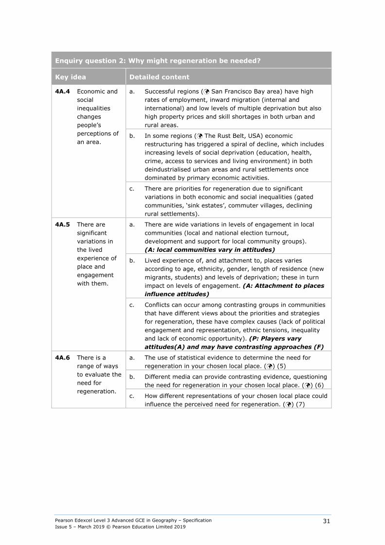
Enquiry question 2: Why might regeneration be needed?
Key idea Detailed content
4A.4 Economic and social inequalities changes people’s perceptions of an area.
a. Successful regions ( San Francisco Bay area) have high rates of employment, inward migration (internal and international) and low levels of multiple deprivation but also high property prices and skill shortages in both urban and rural areas.
b. In some regions ( The Rust Belt, USA) economic restructuring has triggered a spiral of decline, which includes increasing levels of social deprivation (education, health, crime, access to services and living environment) in both deindustrialised urban areas and rural settlements once dominated by primary economic activities.
c. There are priorities for regeneration due to significant variations in both economic and social inequalities (gated communities, ‘sink estates’, commuter villages, declining rural settlements).
4A.5 There are significant variations in the lived experience of place and engagement with them.
a. There are wide variations in levels of engagement in local communities (local and national election turnout, development and support for local community groups). (A: local communities vary in attitudes)
b. Lived experience of, and attachment to, places varies according to age, ethnicity, gender, length of residence (new migrants, students) and levels of deprivation; these in turn impact on levels of engagement. (A: Attachment to places influence attitudes)
c. Conflicts can occur among contrasting groups in communities that have different views about the priorities and strategies for regeneration, these have complex causes (lack of political engagement and representation, ethnic tensions, inequality and lack of economic opportunity). (P: Players vary attitudes(A) and may have contrasting approaches (F)
4A.6 There is a range of ways to evaluate the need for regeneration.
a. The use of statistical evidence to determine the need for regeneration in your chosen local place. () (5)
b. Different media can provide contrasting evidence, questioning the need for regeneration in your chosen local place. () (6)
c. How different representations of your chosen local place could influence the perceived need for regeneration. () (7)
Pearson Edexcel Level 3 Advanced GCE in Geography – Specification Issue 5 – March 2019 © Pearson Education Limited 2019
32
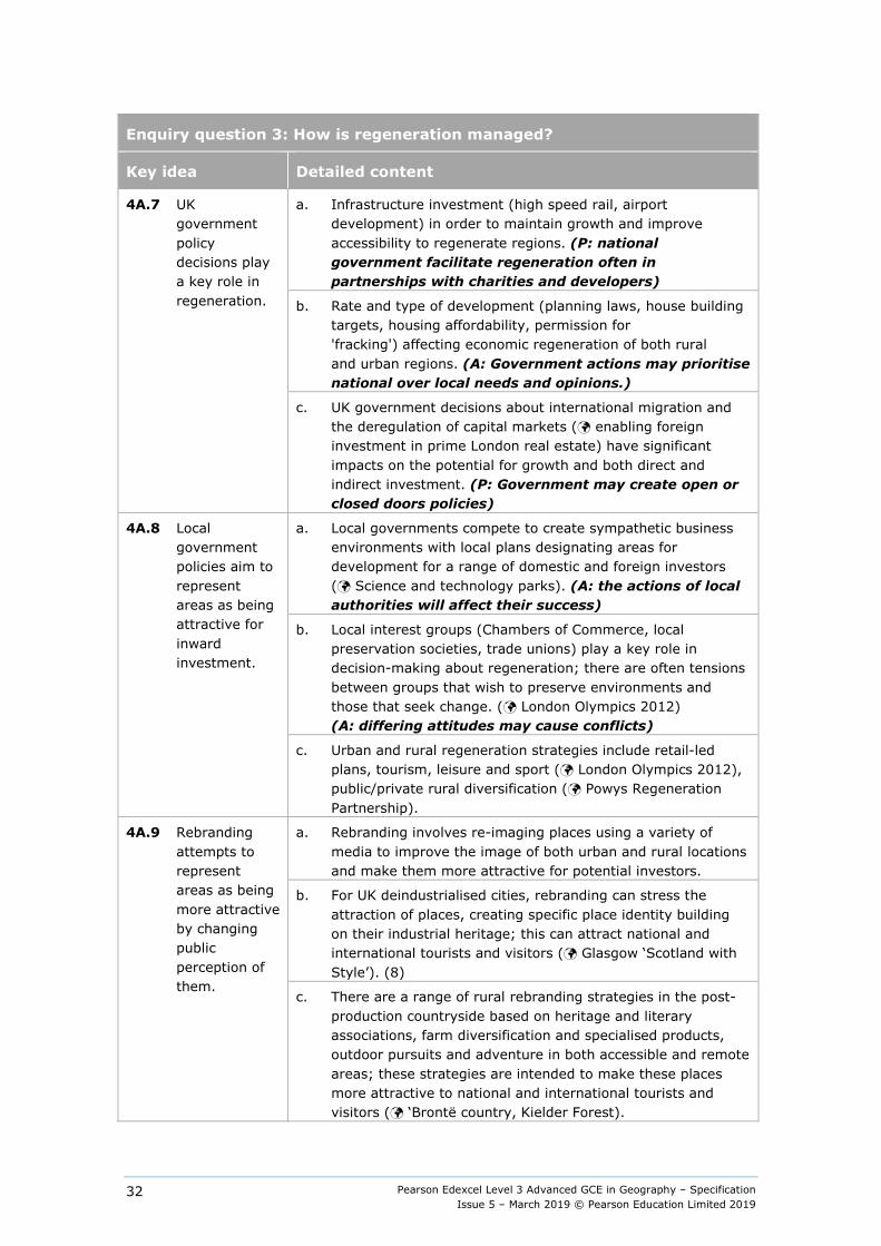
Enquiry question 3: How is regeneration managed?
Key idea Detailed content
4A.7 UK government policy decisions play a key role in regeneration.
a. Infrastructure investment (high speed rail, airport development) in order to maintain growth and improve accessibility to regenerate regions. (P: national government facilitate regeneration often in partnerships with charities and developers)
b. Rate and type of development (planning laws, house building targets, housing affordability, permission for 'fracking') affecting economic regeneration of both rural and urban regions. (A: Government actions may prioritise national over local needs and opinions.)
c. UK government decisions about international migration and the deregulation of capital markets ( enabling foreign investment in prime London real estate) have significant impacts on the potential for growth and both direct and indirect investment. (P: Government may create open or closed doors policies)
4A.8 Local government policies aim to represent areas as being attractive for inward investment.
a. Local governments compete to create sympathetic business environments with local plans designating areas for development for a range of domestic and foreign investors ( Science and technology parks). (A: the actions of local authorities will affect their success)
b. Local interest groups (Chambers of Commerce, local preservation societies, trade unions) play a key role in decision-making about regeneration; there are often tensions between groups that wish to preserve environments and those that seek change. ( London Olympics 2012) (A: differing attitudes may cause conflicts)
c. Urban and rural regeneration strategies include retail-led plans, tourism, leisure and sport ( London Olympics 2012), public/private rural diversification ( Powys Regeneration Partnership).
4A.9 Rebranding attempts to represent areas as being more attractive by changing public perception of them.
a. Rebranding involves re-imaging places using a variety of media to improve the image of both urban and rural locations and make them more attractive for potential investors.
b. For UK deindustrialised cities, rebranding can stress the attraction of places, creating specific place identity building on their industrial heritage; this can attract national and international tourists and visitors ( Glasgow ‘Scotland with Style’). (8)
c. There are a range of rural rebranding strategies in the post- production countryside based on heritage and literary associations, farm diversification and specialised products, outdoor pursuits and adventure in both accessible and remote areas; these strategies are intended to make these places more attractive to national and international tourists and visitors ( ‘Brontë country, Kielder Forest).
Pearson Edexcel Level 3 Advanced GCE in Geography – Specification Issue 5 – March 2019 © Pearson Education Limited 2019
33
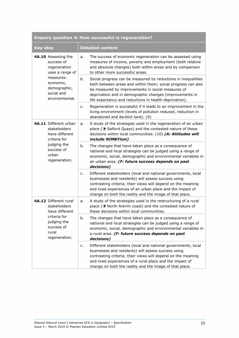
Enquiry question 4: How successful is regeneration?
Key idea Detailed content
4A.10 Assessing the success of regeneration uses a range of measures: economic, demographic, social and environmental.
a. The success of economic regeneration can be assessed using measures of income, poverty and employment (both relative and absolute changes) both within areas and by comparison to other more successful areas.
b. Social progress can be measured by reductions in inequalities both between areas and within them; social progress can also be measured by improvements in social measures of deprivation and in demographic changes (improvements in life expectancy and reductions in health deprivation).
c. Regeneration is successful if it leads to an improvement in the living environment (levels of pollution reduced, reduction in abandoned and derelict land). (9)
4A.11 Different urban stakeholders have different criteria for judging the success of urban regeneration.
a. A study of the strategies used in the regeneration of an urban place ( Salford Quays) and the contested nature of these decisions within local communities. (10) (A: Attitudes will include NIMBYism)
b. The changes that have taken place as a consequence of national and local strategies can be judged using a range of economic, social, demographic and environmental variables in an urban area. (F: future success depends on past decisions)
c. Different stakeholders (local and national governments, local businesses and residents) will assess success using contrasting criteria; their views will depend on the meaning and lived experiences of an urban place and the impact of change on both the reality and the image of that place.
4A.12 Different rural stakeholders have different criteria for judging the success of rural regeneration.
a. A study of the strategies used in the restructuring of a rural place ( North Antrim coast) and the contested nature of these decisions within local communities.
b. The changes that have taken place as a consequence of national and local strategies can be judged using a range of economic, social, demographic and environmental variables in a rural area. (F: future success depends on past decisions)
c. Different stakeholders (local and national governments, local businesses and residents) will assess success using contrasting criteria; their views will depend on the meaning and lived experiences of a rural place and the impact of change on both the reality and the image of that place.
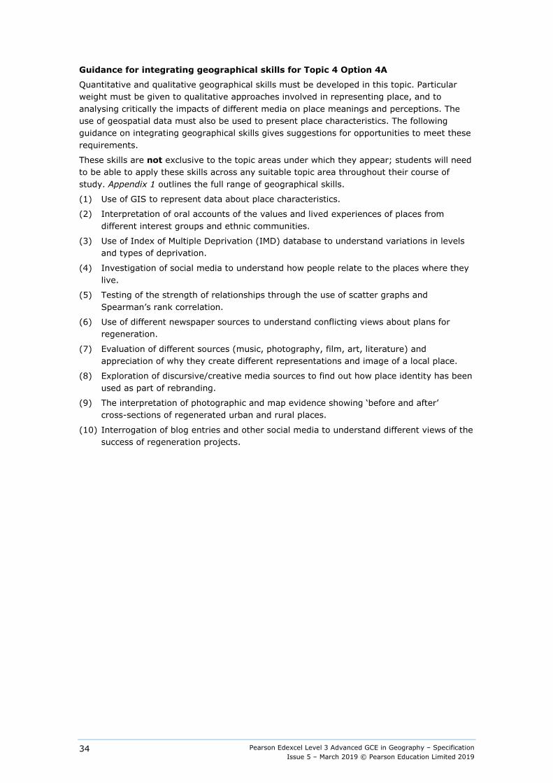
Pearson Edexcel Level 3 Advanced GCE in Geography – Specification Issue 5 – March 2019 © Pearson Education Limited 2019
34
Guidance for integrating geographical skills for Topic 4 Option 4A
Quantitative and qualitative geographical skills must be developed in this topic. Particular weight must be given to qualitative approaches involved in representing place, and to analysing critically the impacts of different media on place meanings and perceptions. The use of geospatial data must also be used to present place characteristics. The following guidance on integrating geographical skills gives suggestions for opportunities to meet these requirements.
These skills are not exclusive to the topic areas under which they appear; students will need to be able to apply these skills across any suitable topic area throughout their course of study. Appendix 1 outlines the full range of geographical skills.
(1) Use of GIS to represent data about place characteristics.
(2) Interpretation of oral accounts of the values and lived experiences of places from different interest groups and ethnic communities.
(3) Use of Index of Multiple Deprivation (IMD) database to understand variations in levels and types of deprivation.
(4) Investigation of social media to understand how people relate to the places where they live.
(5) Testing of the strength of relationships through the use of scatter graphs and Spearman’s rank correlation.
(6) Use of different newspaper sources to understand conflicting views about plans for regeneration.
(7) Evaluation of different sources (music, photography, film, art, literature) and appreciation of why they create different representations and image of a local place.
(8) Exploration of discursive/creative media sources to find out how place identity has been used as part of rebranding.
(9) The interpretation of photographic and map evidence showing ‘before and after’ cross-sections of regenerated urban and rural places.
(10) Interrogation of blog entries and other social media to understand different views of the success of regeneration projects.
Pearson Edexcel Level 3 Advanced GCE in Geography – Specification Issue 5 – March 2019 © Pearson Education Limited 2019
35
Topic 4: Shaping Places
Option 4B: Diverse Places
Overview Local places vary both demographically and culturally with change driven by local, national and global processes. These processes include movements of people, capital, information and resources, making some places more demographically and culturally heterogeneous while other places appear to be less dynamic. This creates and exacerbates considerable social inequalities both between and within local areas.
Variations in past and present connections with places lead to very different lived experiences of places at a local level. This is because demographic and cultural changes impact variably on people in terms of the lived experience of change and their perception of and attachment to places. The relative success of the management of demographic and cultural changes for individuals and groups depends on that lived experience of change and how perceptions of, and attachments to, the place are changed.
Students should begin by studying the place in which they live or study in order to look at demographic and social changes. They will then put this local place in context in order to understand how regional, national, international and global influences have led to changes in this place. They should then study one further contrasting place, which will develop wider knowledge and understanding about how places change and are shaped. A local place may be a locality, a neighbourhood or a small community, either urban or rural.
Content
Enquiry question 1: How do population structures vary?
An in-depth study of the local place in which you live or study and one contrasting place
Key idea Key idea
4B.1 Population structure varies from place to place and over time.
a. The population of the UK has grown unevenly in the last 50 years, with some regions growing rapidly ( London and the south-east) whilst others have grown more slowly ( the north-east of England).
b. Population structure and density varies according to placement in the rural-urban continuum and, therefore accessibility, physical factors, historical development and the role of planning.
c. Population structure and dynamics are a result of differences in fertility and mortality rates as well as international and internal migration.
Pearson Edexcel Level 3 Advanced GCE in Geography – Specification Issue 5 – March 2019 © Pearson Education Limited 2019
36
Enquiry question 1: How do population structures vary?
An in-depth study of the local place in which you live or study and one contrasting place
Key idea Detailed content
4B.2 Population characteristics vary from place to place and over time.
a. There can be considerable variation in population characteristics (gender and ethnicity), both in and between settlements.
b. Different levels of cultural diversity in places can be explained by social clustering, accessibility to key cities, physical factors and government planning policy. (A: actions by governments may foster or supress diversity)
c. Fertility and mortality rates, as well as international and internal migration, are changing the cultural characteristics of places.
4B.3 How past and present connections have shaped the demographic and cultural characteristics of your chosen places.
a. Regional and national influences that have shaped the characteristics of your chosen places. These places can be represented in a variety of different forms, giving contrasting images to that presented more formally and statistically. How lives of students and those of others are affected by this continuity and change, both real and imagined.
b. International and global influences that have shaped your chosen places. These places can be represented in a variety of different forms, giving contrasting images to that presented more formally and statistically. How the lives of students and those of others are affected by this continuity and change, both real and imagined. (P: increasing roles of especially TNCs and IGOs)
c. Consideration of the way in which the demographic and cultural changes in your chosen local place have impacted on people’s identity. (1)
Pearson Edexcel Level 3 Advanced GCE in Geography – Specification Issue 5 – March 2019 © Pearson Education Limited 2019
37
Enquiry question 2: How do different people view diverse living spaces?
Key idea Detailed content
4B.4 Urban places are seen differently by different groups because of their lived experience of places and their perception of those places.
a. During industrialisation, urban places were perceived by some as dangerous and threatening ( Victorian London); currently they could be seen as attractive because of their range of economic opportunities and the variety of social and leisure activities that attract young people and migrants.
b. Some urban locations are perceived as undesirable or even threatening by residents and/or outsiders due to high crime rates, low environmental quality, population characteristics and reputation based on quantitative data but also due to lived experience and media representation. (2)
c. Suburban and inner-city areas are perceived differently in terms of their desirability as places to live and work by contrasting demographic groups (by age, ethnicity, life-cycle stage). (3) (A: attitudes may vary)
4B.5 Rural places are seen differently by different groups because of their lived experience of places and their perception of those places.
a. Rural places are often perceived as idyllic because of their tranquillity, natural landscapes and historical and cultural associations ( Hardy’s ‘Wessex’). (4) (A: Urban and rural residents may differ in their attitude to places.)
b. Some rural locations are perceived as undesirable by residents and/or outsiders because of remoteness, limited social opportunities, limited range of services, high transport costs, population characteristics and reputation based on quantitative data but also because of lived experience and media representation.
c. Rural areas are viewed in different ways: from very remote areas to retirement villages and commuter villages. (A: attitudes may vary)
4B.6 There is a range of ways to evaluate how people view their living spaces.
a. The use of statistical evidence to determine whether people have a positive or negative image of your chosen local place. () (5)
b. Different media can provide contrasting evidence about the image different people have of your chosen local place ().
c. How different representations of your chosen local place could be used to influence the perception of cultural and demographic issues and conflict () (6)
Pearson Edexcel Level 3 Advanced GCE in Geography – Specification Issue 5 – March 2019 © Pearson Education Limited 2019
38
Enquiry question 3: Why are there demographic and cultural tensions in diverse places?
Key idea Detailed content
4B.7 Culture and society is now more diverse in the UK.
a. Significant internal movement of people within the UK has created uneven demographic and cultural patterns. ( London and the south-east)
b. Culture and society in the UK has changed because of significant international migration flows from former colonies ( Indian sub-continent and the West Indies) and from the European Union. (P: the main gatekeeper player affecting flows is the Government)
c. Some international migrants choose to live in rural areas for specific reasons, creating social challenges and opportunities. ( East Europeans in Lincolnshire)
4B.8 Levels of segregation reflect cultural, economic and social variation and change over time.
a. International migrants tend to live in distinctive places ( Russian oligarch families in London) with ethnic segregation closely related to economic indicators (income and employment) and social indicators (health, crime and education). (7)
b. Diverse living spaces in urban areas have social characteristics that reflect ethnicity and culture in terms of distinctive retail outlets, places of worship and leisure. ( Southall) (8)
c. Experiences and perceptions of living spaces change over generations as communities have evolved economically and culturally. (A: intergenerational attitudes and norms may change from global cultural trends)
4B.9 Changes to diverse places can lead to tension and conflict.
a. Different community groups, local and national governments and TNCs may make changes to land uses that create challenges and opportunities for local people and their lived experience of place. (A: different actions may have different impacts)
b. There are frequent tensions over the diversity of living spaces, especially between long-term residents who seek continuity and recent in-migrants who may seek change. (9) ( Luton)
c. Changes to the built environment will bring benefits to some groups but can provoke hostility from other groups that perceive migrants as a threat to their culture. Migrants may experience a sense of social exclusion. ( Glasgow) (P: planners and developers may make controversial decisions.)

Pearson Edexcel Level 3 Advanced GCE in Geography – Specification Issue 5 – March 2019 © Pearson Education Limited 2019
39
Enquiry question 4: How successfully are cultural and demographic issues managed?
Key idea Detailed content
4B.10 The management of cultural and demographic issues can be measured using a range of techniques.
a. Management can be assessed using measures of income and employment (both relative and absolute changes) both in areas and by comparison to other areas.
b. Social progress can be measured by reductions in inequalities both between areas and within them as well as improvements in social measures of deprivation and demographic changes (improvements in life expectancy). (8)
c. Assimilation of different cultures can be measured by levels of political engagement through voter turnout, the development of local community groups and reductions in ‘hate’ crime and racism.
4B.11 Different urban stakeholders have different criteria for assessing the success of managing change in diverse urban communities.
a. A study of the contrasting ways in which different demographic and ethnic groups view an urban living space and the impact of national and local strategies in resolving issues ( Aik Saath in Slough).
b. The changes that have taken place can be judged using a range of economic, social, demographic and environmental variables in the changing urban area. (F: changes may create differing legacies)
c. Different stakeholders (local and national governments, local businesses and residents) will assess success using contrasting criteria depending on the meaning of the place and the impact of change on both the reality and their image of that place. (10) (A: ‘success’ depends on the attitudes of different players)
4B.12 Different rural stakeholders have different criteria for assessing the success of managing change in diverse rural communities.
a. A study of the contrasting ways in which different demographic and ethnic groups view a rural living space and the impact of national and local strategies on a rural area ( Lake District Rural Revival Partnerships).
b. The changes that have taken place can be judged using a range of economic, social, demographic and environmental variables in the changing rural area. (F: changes may create differing legacies)
c. Different stakeholders (local and national governments, local businesses and residents) will assess success using contrasting criteria, depending on the meaning of the place and the impact of change on both the reality and their image of that place. (A: ‘success’ depends on the attitudes of different players)
Pearson Edexcel Level 3 Advanced GCE in Geography – Specification Issue 5 – March 2019 © Pearson Education Limited 2019
40
Guidance for integrating geographical skills for Topic 4 Option 4B
Quantitative and qualitative geographical skills must be developed in this topic. Particular weight must be given to qualitative approaches involved in representing place and to critically analysing the impacts of different media on place meanings and perceptions. The use of geospatial data must also be used to present place characteristics. The following guidance on integrating geographical skills gives suggestions for opportunities to meet these requirements.
These skills are not exclusive to the topic areas under which they appear; students will need to be able to apply these skills across any suitable topic area throughout their course of study. Appendix 1 outlines the full range of geographical skills.
(1) Investigation of social media to understand how people relate to the places where they live.
(2) Use of GIS to represent and analyse crime data and to show variations in levels of crime across communities.
(3) Interviews with local residents to interpret information representing cultural and demographic issues in a local place.
(4) Interpretation of qualitative information (advertising copy, tourist agency material, local art exhibitions) to show both its significance and what it means about a chosen local place.
(5) Testing of the strength of relationships through the use of scattergraphs and Spearman’s rank correlation.
(6) Evaluation of different sources (music, photography, film, art, literature) and appreciation of why they create different representations and image of a local place.
(7) Use of indexes to measure ethnic and cultural diversity.
(8) Interpretation of photographic and map evidence showing ‘before and after’ cross-sections.
(9) Interpretation of oral accounts of the values and lived experiences of places from different interest groups and ethnic communities.
(10) Analysis of contrasting newspaper reports about a change, including opinions about that change.
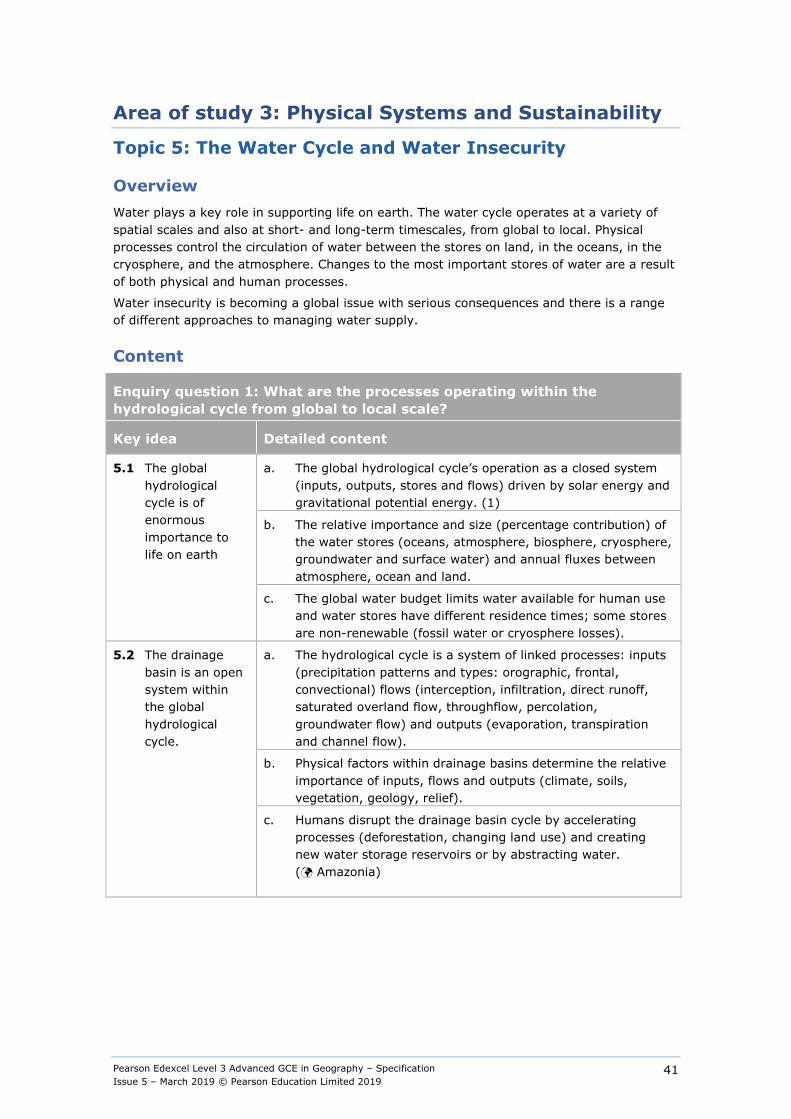
Pearson Edexcel Level 3 Advanced GCE in Geography – Specification Issue 5 – March 2019 © Pearson Education Limited 2019
41
Area of study 3: Physical Systems and Sustainability
Topic 5: The Water Cycle and Water Insecurity
Overview Water plays a key role in supporting life on earth. The water cycle operates at a variety of spatial scales and also at short- and long-term timescales, from global to local. Physical processes control the circulation of water between the stores on land, in the oceans, in the cryosphere, and the atmosphere. Changes to the most important stores of water are a result of both physical and human processes.
Water insecurity is becoming a global issue with serious consequences and there is a range of different approaches to managing water supply.
Content
Enquiry question 1: What are the processes operating within the hydrological cycle from global to local scale?
Key idea Detailed content
5.1 The global hydrological cycle is of enormous importance to life on earth
a. The global hydrological cycle’s operation as a closed system (inputs, outputs, stores and flows) driven by solar energy and gravitational potential energy. (1)
b. The relative importance and size (percentage contribution) of the water stores (oceans, atmosphere, biosphere, cryosphere, groundwater and surface water) and annual fluxes between atmosphere, ocean and land.
c. The global water budget limits water available for human use and water stores have different residence times; some stores are non-renewable (fossil water or cryosphere losses).
5.2 The drainage basin is an open system within the global hydrological cycle.
a. The hydrological cycle is a system of linked processes: inputs (precipitation patterns and types: orographic, frontal, convectional) flows (interception, infiltration, direct runoff, saturated overland flow, throughflow, percolation, groundwater flow) and outputs (evaporation, transpiration and channel flow).
b. Physical factors within drainage basins determine the relative importance of inputs, flows and outputs (climate, soils, vegetation, geology, relief).
c. Humans disrupt the drainage basin cycle by accelerating processes (deforestation, changing land use) and creating new water storage reservoirs or by abstracting water. ( Amazonia)
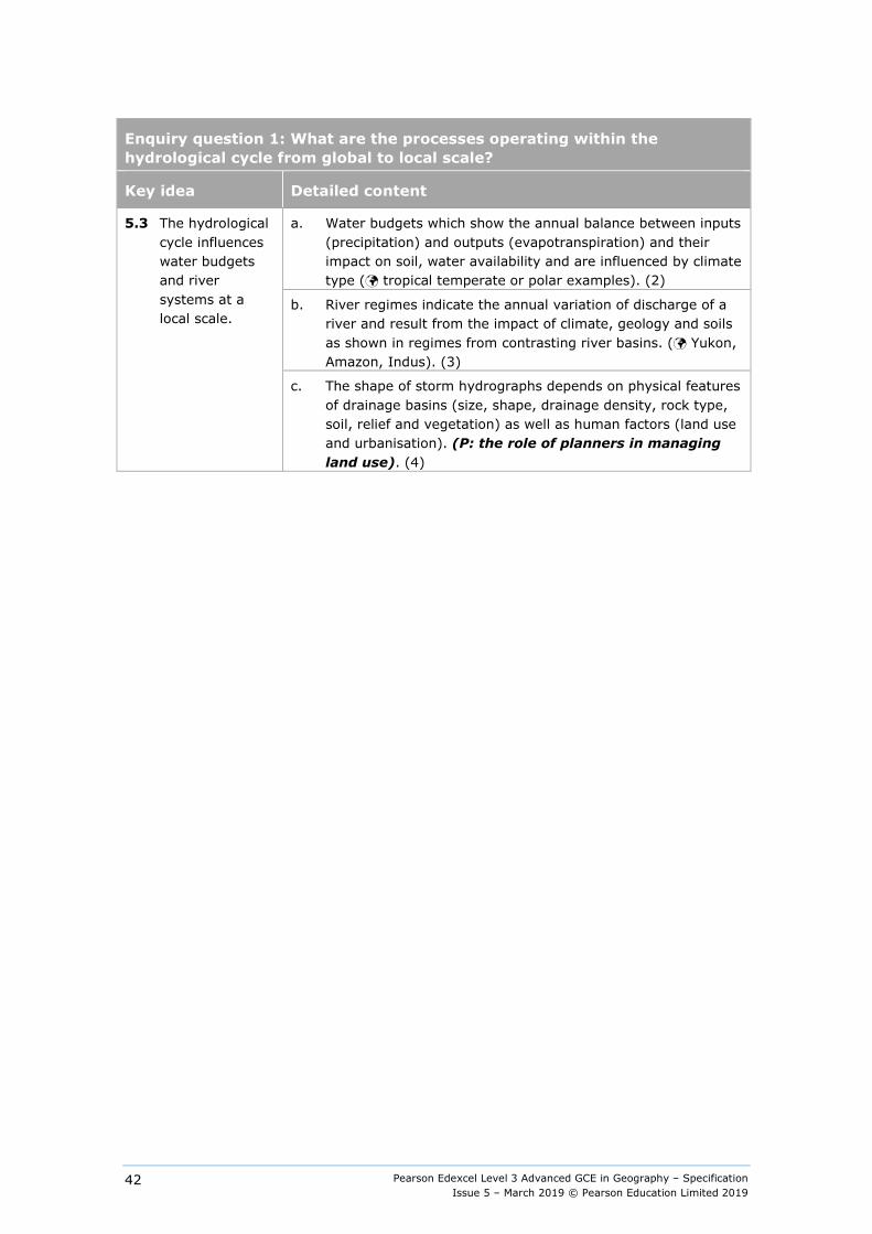
Pearson Edexcel Level 3 Advanced GCE in Geography – Specification Issue 5 – March 2019 © Pearson Education Limited 2019
42
Enquiry question 1: What are the processes operating within the hydrological cycle from global to local scale?
Key idea Detailed content
5.3 The hydrological cycle influences water budgets and river systems at a local scale.
a. Water budgets which show the annual balance between inputs (precipitation) and outputs (evapotranspiration) and their impact on soil, water availability and are influenced by climate type ( tropical temperate or polar examples). (2)
b. River regimes indicate the annual variation of discharge of a river and result from the impact of climate, geology and soils as shown in regimes from contrasting river basins. ( Yukon, Amazon, Indus). (3)
c. The shape of storm hydrographs depends on physical features of drainage basins (size, shape, drainage density, rock type, soil, relief and vegetation) as well as human factors (land use and urbanisation). (P: the role of planners in managing land use). (4)
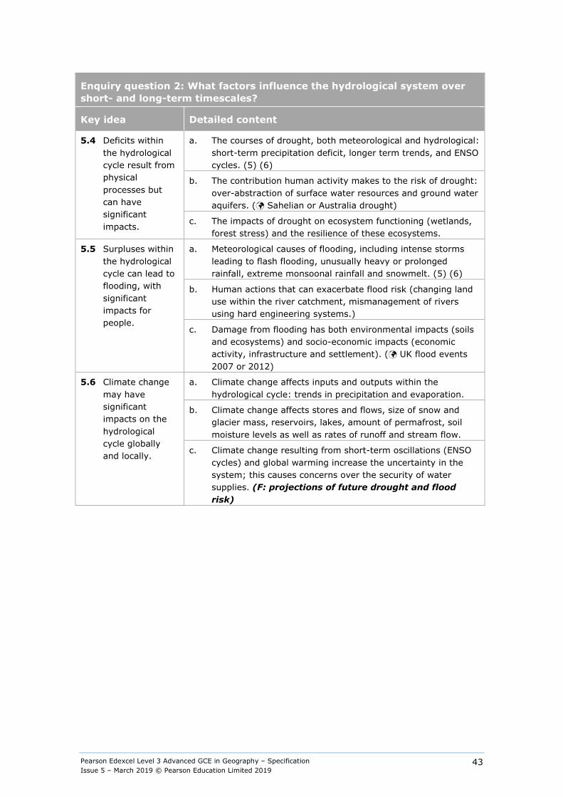
Pearson Edexcel Level 3 Advanced GCE in Geography – Specification Issue 5 – March 2019 © Pearson Education Limited 2019
43
Enquiry question 2: What factors influence the hydrological system over short- and long-term timescales?
Key idea Detailed content
5.4 Deficits within the hydrological cycle result from physical processes but can have significant impacts.
a. The courses of drought, both meteorological and hydrological: short-term precipitation deficit, longer term trends, and ENSO cycles. (5) (6)
b. The contribution human activity makes to the risk of drought: over-abstraction of surface water resources and ground water aquifers. ( Sahelian or Australia drought)
c. The impacts of drought on ecosystem functioning (wetlands, forest stress) and the resilience of these ecosystems.
5.5 Surpluses within the hydrological cycle can lead to flooding, with significant impacts for people.
a. Meteorological causes of flooding, including intense storms leading to flash flooding, unusually heavy or prolonged rainfall, extreme monsoonal rainfall and snowmelt. (5) (6)
b. Human actions that can exacerbate flood risk (changing land use within the river catchment, mismanagement of rivers using hard engineering systems.)
c. Damage from flooding has both environmental impacts (soils and ecosystems) and socio-economic impacts (economic activity, infrastructure and settlement). ( UK flood events 2007 or 2012)
5.6 Climate change may have significant impacts on the hydrological cycle globally and locally.
a. Climate change affects inputs and outputs within the hydrological cycle: trends in precipitation and evaporation.
b. Climate change affects stores and flows, size of snow and glacier mass, reservoirs, lakes, amount of permafrost, soil moisture levels as well as rates of runoff and stream flow.
c. Climate change resulting from short-term oscillations (ENSO cycles) and global warming increase the uncertainty in the system; this causes concerns over the security of water supplies. (F: projections of future drought and flood risk)
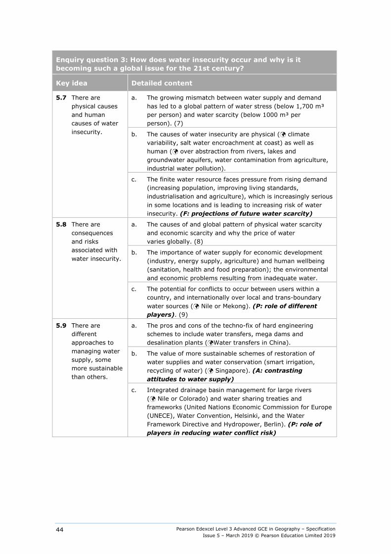
Pearson Edexcel Level 3 Advanced GCE in Geography – Specification Issue 5 – March 2019 © Pearson Education Limited 2019
44
Enquiry question 3: How does water insecurity occur and why is it becoming such a global issue for the 21st century?
Key idea Detailed content
5.7 There are physical causes and human causes of water insecurity.
a. The growing mismatch between water supply and demand has led to a global pattern of water stress (below 1,700 m³ per person) and water scarcity (below 1000 m³ per person). (7)
b. The causes of water insecurity are physical ( climate variability, salt water encroachment at coast) as well as human ( over abstraction from rivers, lakes and groundwater aquifers, water contamination from agriculture, industrial water pollution).
c. The finite water resource faces pressure from rising demand (increasing population, improving living standards, industrialisation and agriculture), which is increasingly serious in some locations and is leading to increasing risk of water insecurity. (F: projections of future water scarcity)
5.8 There are consequences and risks associated with water insecurity.
a. The causes of and global pattern of physical water scarcity and economic scarcity and why the price of water varies globally. (8)
b. The importance of water supply for economic development (industry, energy supply, agriculture) and human wellbeing (sanitation, health and food preparation); the environmental and economic problems resulting from inadequate water.
c. The potential for conflicts to occur between users within a country, and internationally over local and trans-boundary water sources ( Nile or Mekong). (P: role of different players). (9)
5.9 There are different approaches to managing water supply, some more sustainable than others.
a. The pros and cons of the techno-fix of hard engineering schemes to include water transfers, mega dams and desalination plants (Water transfers in China).
b. The value of more sustainable schemes of restoration of water supplies and water conservation (smart irrigation, recycling of water) ( Singapore). (A: contrasting attitudes to water supply)
c. Integrated drainage basin management for large rivers ( Nile or Colorado) and water sharing treaties and frameworks (United Nations Economic Commission for Europe (UNECE), Water Convention, Helsinki, and the Water Framework Directive and Hydropower, Berlin). (P: role of players in reducing water conflict risk)

Pearson Edexcel Level 3 Advanced GCE in Geography – Specification Issue 5 – March 2019 © Pearson Education Limited 2019
45
Guidance for integrating geographical skills for Topic 5
Quantitative geographical skills must be developed in this topic, including understanding of simple mass balance, unit conversions, and the analysis and presentation of data. Qualitative approaches may be used if appropriate. The following guidance on integrating geographical skills gives suggestions for opportunities to meet these requirements.
These skills are not exclusive to the topic areas under which they appear; students will need to be able to apply these skills across any suitable topic area throughout their course of study. Appendix 1 outlines the full range of geographical skills.
(1) Use of diagrams showing proportional flows within systems.
(2) Comparative analysis of river regime annual discharges.
(3) Analysis and construction of Water Budget graphs.
(4) Using comparative data, labelling of features of storm hydrographs.
(5) Use of large database to study the pattern and trends in floods and droughts worldwide.
(6) Interpretation of synoptic charts and weather patterns, leading to droughts and floods.
(7) Use of a global map to analyse world water stress and scarcity.
(8) Interpretation of water poverty indexes using diamond diagrams for countries at different levels of development.
(9) Identify seasonal variations in the regime of international rivers, such as the Nile and the Mekong and assess impact of existing and potential dams.
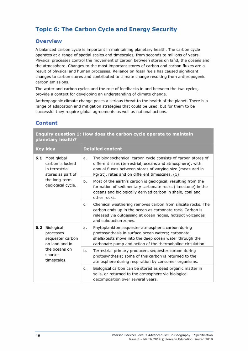
Pearson Edexcel Level 3 Advanced GCE in Geography – Specification Issue 5 – March 2019 © Pearson Education Limited 2019
46
Topic 6: The Carbon Cycle and Energy Security
Overview A balanced carbon cycle is important in maintaining planetary health. The carbon cycle operates at a range of spatial scales and timescales, from seconds to millions of years. Physical processes control the movement of carbon between stores on land, the oceans and the atmosphere. Changes to the most important stores of carbon and carbon fluxes are a result of physical and human processes. Reliance on fossil fuels has caused significant changes to carbon stores and contributed to climate change resulting from anthropogenic carbon emissions.
The water and carbon cycles and the role of feedbacks in and between the two cycles, provide a context for developing an understanding of climate change.
Anthropogenic climate change poses a serious threat to the health of the planet. There is a range of adaptation and mitigation strategies that could be used, but for them to be successful they require global agreements as well as national actions.
Content
Enquiry question 1: How does the carbon cycle operate to maintain planetary health?
Key idea Detailed content
6.1 Most global carbon is locked in terrestrial stores as part of the long-term geological cycle.
a. The biogeochemical carbon cycle consists of carbon stores of different sizes (terrestrial, oceans and atmosphere), with annual fluxes between stores of varying size (measured in Pg/Gt), rates and on different timescales. (1)
b. Most of the earth’s carbon is geological, resulting from the formation of sedimentary carbonate rocks (limestone) in the oceans and biologically derived carbon in shale, coal and other rocks.
c. Chemical weathering removes carbon from silicate rocks. The carbon ends up in the ocean as carbonate rock. Carbon is released via outgassing at ocean ridges, hotspot volcanoes and subduction zones.
6.2 Biological processes sequester carbon on land and in the oceans on shorter timescales.
a. Phytoplankton sequester atmospheric carbon during photosynthesis in surface ocean waters; carbonate shells/tests move into the deep ocean water through the carbonate pump and action of the thermohaline circulation.
b. Terrestrial primary producers sequester carbon during photosynthesis; some of this carbon is returned to the atmosphere during respiration by consumer organisms.
c. Biological carbon can be stored as dead organic matter in soils, or returned to the atmosphere via biological decomposition over several years.
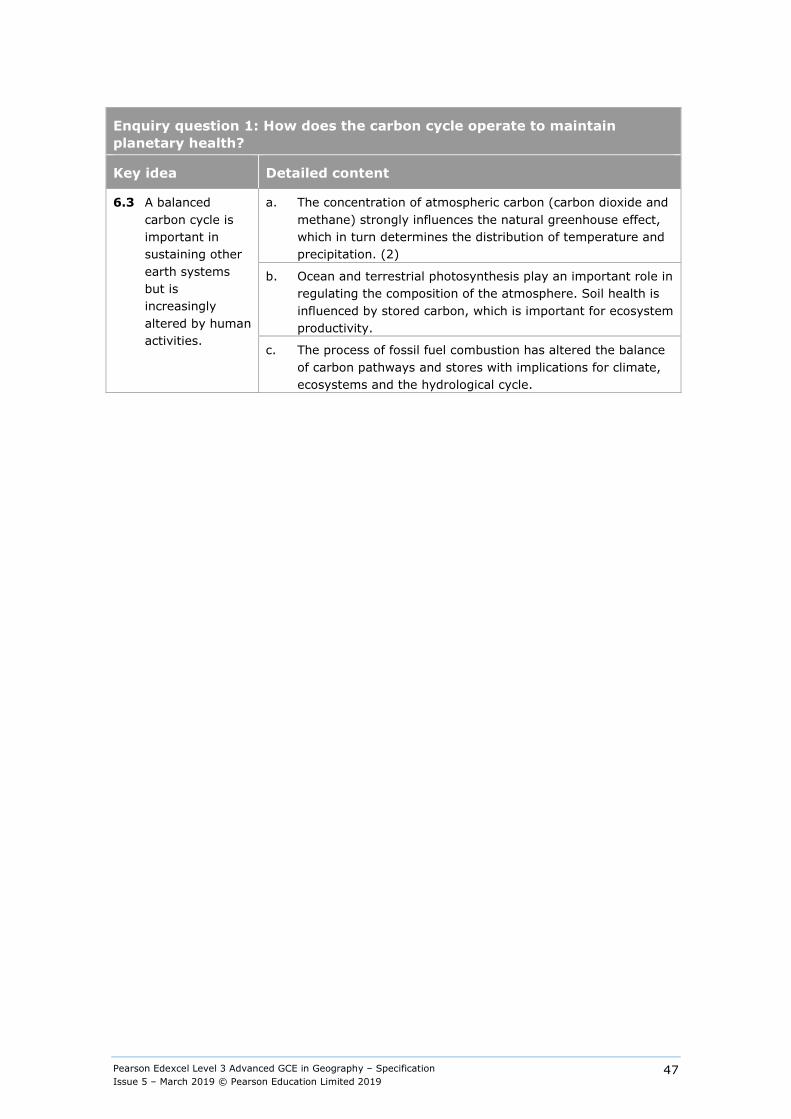
Pearson Edexcel Level 3 Advanced GCE in Geography – Specification Issue 5 – March 2019 © Pearson Education Limited 2019
47
Enquiry question 1: How does the carbon cycle operate to maintain planetary health?
Key idea Detailed content
6.3 A balanced carbon cycle is important in sustaining other earth systems but is increasingly altered by human activities.
a. The concentration of atmospheric carbon (carbon dioxide and methane) strongly influences the natural greenhouse effect, which in turn determines the distribution of temperature and precipitation. (2)
b. Ocean and terrestrial photosynthesis play an important role in regulating the composition of the atmosphere. Soil health is influenced by stored carbon, which is important for ecosystem productivity.
c. The process of fossil fuel combustion has altered the balance of carbon pathways and stores with implications for climate, ecosystems and the hydrological cycle.
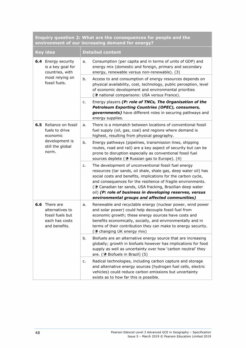
Pearson Edexcel Level 3 Advanced GCE in Geography – Specification Issue 5 – March 2019 © Pearson Education Limited 2019
48
Enquiry question 2: What are the consequences for people and the environment of our increasing demand for energy?
Key idea Detailed content
6.4 Energy security is a key goal for countries, with most relying on fossil fuels.
a. Consumption (per capita and in terms of units of GDP) and energy mix (domestic and foreign, primary and secondary energy, renewable versus non-renewable). (3)
b. Access to and consumption of energy resources depends on physical availability, cost, technology, public perception, level of economic development and environmental priorities ( national comparisons: USA versus France).
c. Energy players (P: role of TNCs, The Organisation of the Petroleum Exporting Countries (OPEC), consumers, governments) have different roles in securing pathways and energy supplies.
6.5 Reliance on fossil fuels to drive economic development is still the global norm.
a. There is a mismatch between locations of conventional fossil fuel supply (oil, gas, coal) and regions where demand is highest, resulting from physical geography.
b. Energy pathways (pipelines, transmission lines, shipping routes, road and rail) are a key aspect of security but can be prone to disruption especially as conventional fossil fuel sources deplete ( Russian gas to Europe). (4)
c. The development of unconventional fossil fuel energy resources (tar sands, oil shale, shale gas, deep water oil) has social costs and benefits, implications for the carbon cycle, and consequences for the resilience of fragile environments. ( Canadian tar sands, USA fracking, Brazilian deep water oil) (P: role of business in developing reserves, versus environmental groups and affected communities)
6.6 There are alternatives to fossil fuels but each has costs and benefits.
a. Renewable and recyclable energy (nuclear power, wind power and solar power) could help decouple fossil fuel from economic growth; these energy sources have costs and benefits economically, socially, and environmentally and in terms of their contribution they can make to energy security. ( changing UK energy mix)
b. Biofuels are an alternative energy source that are increasing globally; growth in biofuels however has implications for food supply as well as uncertainty over how ‘carbon neutral’ they are. ( Biofuels in Brazil) (5)
c. Radical technologies, including carbon capture and storage and alternative energy sources (hydrogen fuel cells, electric vehicles) could reduce carbon emissions but uncertainty exists as to how far this is possible.
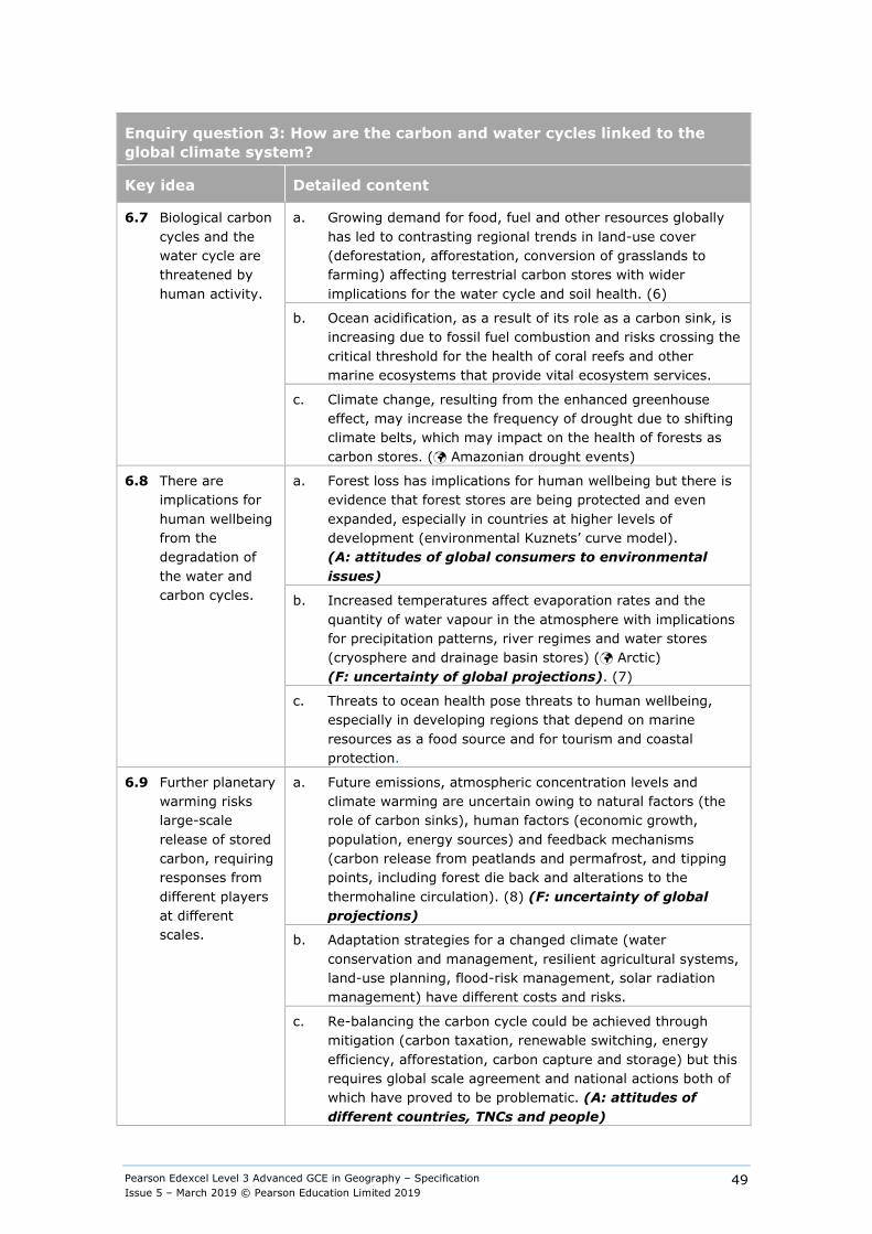
Pearson Edexcel Level 3 Advanced GCE in Geography – Specification Issue 5 – March 2019 © Pearson Education Limited 2019
49
Enquiry question 3: How are the carbon and water cycles linked to the global climate system?
Key idea Detailed content
6.7 Biological carbon cycles and the water cycle are threatened by human activity.
a. Growing demand for food, fuel and other resources globally has led to contrasting regional trends in land-use cover (deforestation, afforestation, conversion of grasslands to farming) affecting terrestrial carbon stores with wider implications for the water cycle and soil health. (6)
b. Ocean acidification, as a result of its role as a carbon sink, is increasing due to fossil fuel combustion and risks crossing the critical threshold for the health of coral reefs and other marine ecosystems that provide vital ecosystem services.
c. Climate change, resulting from the enhanced greenhouse effect, may increase the frequency of drought due to shifting climate belts, which may impact on the health of forests as carbon stores. ( Amazonian drought events)
6.8 There are implications for human wellbeing from the degradation of the water and carbon cycles.
a. Forest loss has implications for human wellbeing but there is evidence that forest stores are being protected and even expanded, especially in countries at higher levels of development (environmental Kuznets’ curve model). (A: attitudes of global consumers to environmental issues)
b. Increased temperatures affect evaporation rates and the quantity of water vapour in the atmosphere with implications for precipitation patterns, river regimes and water stores (cryosphere and drainage basin stores) ( Arctic) (F: uncertainty of global projections). (7)
c. Threats to ocean health pose threats to human wellbeing, especially in developing regions that depend on marine resources as a food source and for tourism and coastal protection.
6.9 Further planetary warming risks large-scale release of stored carbon, requiring responses from different players at different scales.
a. Future emissions, atmospheric concentration levels and climate warming are uncertain owing to natural factors (the role of carbon sinks), human factors (economic growth, population, energy sources) and feedback mechanisms (carbon release from peatlands and permafrost, and tipping points, including forest die back and alterations to the thermohaline circulation). (8) (F: uncertainty of global projections)
b. Adaptation strategies for a changed climate (water conservation and management, resilient agricultural systems, land-use planning, flood-risk management, solar radiation management) have different costs and risks.
c. Re-balancing the carbon cycle could be achieved through mitigation (carbon taxation, renewable switching, energy efficiency, afforestation, carbon capture and storage) but this requires global scale agreement and national actions both of which have proved to be problematic. (A: attitudes of different countries, TNCs and people)

Pearson Edexcel Level 3 Advanced GCE in Geography – Specification Issue 5 – March 2019 © Pearson Education Limited 2019
50
Guidance for integrating geographical skills for Topic 6
Quantitative geographical skills must be developed in this topic, including understanding of simple mass balance, unit conversions and the analysis and presentation of data. Qualitative approaches may be used if appropriate. The following guidance on integrating geographical skills gives suggestions for opportunities to meet these requirements.
These skills are not exclusive to the topic areas under which they appear; students will need to be able to apply these skills across any suitable topic area throughout their course of study. Appendix 1 outlines the full range of geographical skills.
(1) Use of proportional flow diagrams showing carbon fluxes.
(2) Use of maps showing global temperature and precipitation distribution.
(3) Graphical analysis of the energy mix of different countries, including change over time.
(4) Analysis of maps showing global energy trade and flows.
(5) Comparisons of emissions from different energy source.
(6) Using GIS to map land-use changes such as deforestation over time.
(7) Analysis of climate model maps to identify areas at most risk from water shortages, floods in the future.
(8) Plotting graphs of carbon dioxide levels, calculating means and rates of change.

Pearson Edexcel Level 3 Advanced GCE in Geography – Specification Issue 5 – March 2019 © Pearson Education Limited 2019
51
Area of study 4: Human Systems and Geopolitics
Topic 7: Superpowers
Overview Superpowers can be developed by a number of characteristics. The pattern of dominance has changed over time. Superpowers and emerging superpowers have a very significant impact on the global economy, global politics and the environment. The spheres of influence between these powers are frequently contested, resulting in geopolitical implications.
Content
Enquiry question 1: What are superpowers and how have they changed over time?
Key idea Detailed content
7.1 Geopolitical power stems from a range of human and physical characteristics of superpowers.
a. Superpowers, emerging and regional powers can be definedusing contrasting characteristics (economic, political, military,cultural, demographic and access to natural resources). (1)
b. Mechanisms for maintaining power sit on a spectrum from‘hard’ to ‘soft’ power, which vary in their effectiveness.
c. The relative importance of these characteristics andmechanisms for maintaining power has changed over time(Mackinder’s geo-strategic location theory).
7.2 Patterns of power change over time and can be uni-, bi- or multi-polar.
a. The maintenance of power during the imperial era by directcolonial control (British Empire, multipolar world 1919–1939).
b. Multi-faceted, indirect control (political, economic, military,cultural) including neo-colonial mechanisms has become moreimportant (Cold War era; emergence of China as a potentialrival to the USA’s hegemony). (2)
c. Different patterns of power bring varying degrees ofgeopolitical stability and risk.
7.3 Emerging powers vary in their influence on people and the physical environment, which can change rapidly over time.
a. A number of emerging countries, including Brazil, Russia,India and China (BRIC) and other G20 members, areconsidered increasingly important to global economic andpolitical systems, as well as global environment governance(UN Climate Change Conference).
b. Each has evolving strengths and weaknesses (economic,political, military, cultural, demographic and environmental)that might inhibit or advance their economic and geopoliticalrole in the future.
c. Development Theory (World Systems Theory, DependencyTheory, Modernisation Theory) can be used to help explainchanging patterns of power.
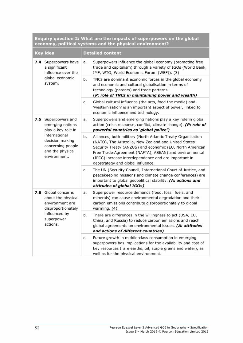
Pearson Edexcel Level 3 Advanced GCE in Geography – Specification Issue 5 – March 2019 © Pearson Education Limited 2019
52
Enquiry question 2: What are the impacts of superpowers on the global economy, political systems and the physical environment?
Key idea Detailed content
7.4 Superpowers have a significant influence over the global economic system.
a. Superpowers influence the global economy (promoting free trade and capitalism) through a variety of IGOs (World Bank, IMF, WTO, World Economic Forum (WEF)). (3)
b. TNCs are dominant economic forces in the global economy and economic and cultural globalisation in terms of technology (patents) and trade patterns. (P: role of TNCs in maintaining power and wealth)
c. Global cultural influence (the arts, food the media) and ‘westernisation’ is an important aspect of power, linked to economic influence and technology.
7.5 Superpowers and emerging nations play a key role in international decision making concerning people and the physical environment.
a. Superpowers and emerging nations play a key role in global action (crisis response, conflict, climate change). (P: role of powerful countries as ‘global police’)
b. Alliances, both military (North Atlantic Treaty Organisation (NATO), The Australia, New Zealand and United States Security Treaty (ANZUS) and economic (EU, North American Free Trade Agreement (NAFTA), ASEAN) and environmental (IPCC) increase interdependence and are important in geostrategy and global influence.
c. The UN (Security Council, International Court of Justice, and peacekeeping missions and climate change conferences) are important to global geopolitical stability. (A: actions and attitudes of global IGOs)
7.6 Global concerns about the physical environment are disproportionately influenced by superpower actions.
a. Superpower resource demands (food, fossil fuels, and minerals) can cause environmental degradation and their carbon emissions contribute disproportionately to global warming. (4)
b. There are differences in the willingness to act (USA, EU, China, and Russia) to reduce carbon emissions and reach global agreements on environmental issues. (A: attitudes and actions of different countries)
c. Future growth in middle-class consumption in emerging superpowers has implications for the availability and cost of key resources (rare earths, oil, staple grains and water), as well as for the physical environment.
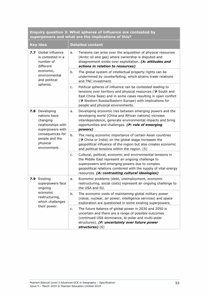
Pearson Edexcel Level 3 Advanced GCE in Geography – Specification Issue 5 – March 2019 © Pearson Education Limited 2019
53
Enquiry question 3: What spheres of influence are contested by superpowers and what are the implications of this?
Key idea Detailed content
7.7 Global influence is contested in a number of different economic, environmental and political spheres.
a. Tensions can arise over the acquisition of physical resources (Arctic oil and gas) where ownership is disputed and disagreement exists over exploitation. (A: attitudes and actions in relation to resources)
b. The global system of intellectual property rights can be undermined by counterfeiting, which strains trade relations and TNC investment.
c. Political spheres of influence can be contested leading to tensions over territory and physical resources ( South and East China Seas) and in some cases resulting in open conflict ( Western Russia/Eastern Europe) with implications for people and physical environments.
7.8 Developing nations have changing relationships with superpowers with consequences for people and the physical environment.
a. Developing economic ties between emerging powers and the developing world (China and African nations) increase interdependence, generate environmental impacts and bring opportunities and challenges. (P: role of emerging powers)
b. The rising economic importance of certain Asian countries ( China or India) on the global stage increases the geopolitical influence of the region but also creates economic and political tensions within the region. (5)
c. Cultural, political, economic and environmental tensions in the Middle East represent an ongoing challenge to superpowers and emerging powers due to complex geopolitical relations combined with the supply of vital energy resources. (A: contrasting cultural ideologies)
7.9 Existing superpowers face ongoing economic restructuring, which challenges their power.
a. Economic problems (debt, unemployment, economic restructuring, social costs) represent an ongoing challenge to the USA and EU.
b. The economic costs of maintaining global military power (naval, nuclear, air power, intelligence services) and space exploration are questioned in some existing superpowers.
c. The future balance of global power in 2030 and 2050 is uncertain and there are a range of possible outcomes (continued USA dominance, bi-polar and multi-polar structures). (F: uncertainty over future power structures) (6)
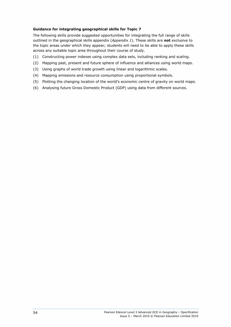
Pearson Edexcel Level 3 Advanced GCE in Geography – Specification Issue 5 – March 2019 © Pearson Education Limited 2019
54
Guidance for integrating geographical skills for Topic 7
The following skills provide suggested opportunities for integrating the full range of skills outlined in the geographical skills appendix (Appendix 1). These skills are not exclusive to the topic areas under which they appear; students will need to be able to apply these skills across any suitable topic area throughout their course of study.
(1) Constructing power indexes using complex data sets, including ranking and scaling.
(2) Mapping past, present and future sphere of influence and alliances using world maps.
(3) Using graphs of world trade growth using linear and logarithmic scales.
(4) Mapping emissions and resource consumption using proportional symbols.
(5) Plotting the changing location of the world’s economic centre of gravity on world maps.
(6) Analysing future Gross Domestic Product (GDP) using data from different sources.
Pearson Edexcel Level 3 Advanced GCE in Geography – Specification Issue 5 – March 2019 © Pearson Education Limited 2019
55
Topic 8: Global Development and Connections
Option 8A: Health, Human Rights and Intervention
Overview Traditional definitions of development are based largely on economic measures but have been increasingly challenged by broader definitions based on environmental, social and political quality of life with many new measures used to record progress at all scales in human rights and human welfare. There are variations in the norms and laws of both national and global institutions that impact on decisions made at all scales, from local to global. These decisions lead to a wide range of geopolitical interventions via international and national policies, from development aid through to military campaigns.
The impact of geopolitical interventions on both human health and wellbeing and human rights is variable and contested, with some groups appearing to benefit disproportionately, which can lead to increasing inequalities and injustice.
Content
Enquiry question 1: What is human development and why do levels vary from place to place?
Key idea Detailed content
8A.1 Concepts of human development are complex and contested.
a. Human development has traditionally been measured using the growth of GDP as an end in itself but the relationship between human contentment and levels of wealth and income is complex (Happy Planet Index) and many dominant models are contested ( Sharia law or Bolivia under Evo Morales). (1)
b. Improvements in environmental quality, health, life expectancy and human rights are seen by some (Rosling) as more significant goals for development while economic growth is often the best means of delivering them.
c. Education is central to economic development (human capital) and to the understanding and assertion of human rights; this view is, however, not universally shared (attitudes to gender equality in education) as both access to education and standards of achievement vary greatly among countries (The United Nations Educational, Scientific and Cultural Organisation (UNESCO).
8A.2 There are notable variations in human health and life expectancy.
a. There are considerable variations in health and life expectancy in the developing world that are explained by differential access to basic needs such as food, water supply and sanitation, and which impact particularly on levels of infant and maternal mortality. (2)
b. Variations in health and life expectancy in the developed world are largely a function of differences in lifestyles, levels of deprivation and the availability, cost and effectiveness of medical care. (2)
c. There are significant variations in health and life expectancy within countries ( UK or Brazil) that can be related to ethnic variations ( Aboriginal peoples in Australia) and income levels and inequalities, which, in turn, impact on lifestyles.
Pearson Edexcel Level 3 Advanced GCE in Geography – Specification Issue 5 – March 2019 © Pearson Education Limited 2019
56
Enquiry question 1: What is human development and why do levels vary from place to place?
Key idea Detailed content
8A.3 Governments and International Government Organisations play a significant role in defining development targets and policies.
a. The relationship between economic and social development is complex and dependent on decisions made by governments on the importance of social progress; this ranges from welfare states with high levels of social spending to totalitarian regimes run by elites with low levels of spending on health and education. (3)
b. The dominant IGOs (World Bank, IMF, WTO) have traditionally promoted neo-liberal views of development based on the adoption of free trade, privatisation and deregulation of financial markets but also, recent programmes have been aimed at improving environmental quality, health, education and human rights.
c. Progress against the United Nation’s Millennium Development Goals (MDGs) has been mixed in terms of individual countries, global regions and targets; the UN post-2015 development agenda expands on the MDGs, setting new goals to include sustainable development.

Pearson Edexcel Level 3 Advanced GCE in Geography – Specification Issue 5 – March 2019 © Pearson Education Limited 2019
57
Enquiry question 2: Why do human rights vary from place to place?
Key idea Detailed content
8A.4 Human rights have become important aspects of both international law and international agreements.
a. The Universal Declaration of Human Rights (UDHR) is a statement of intent and a framework for foreign policy statements to explain economic or military intervention but not all states have signed the Declaration.
b. The European Convention on Human Rights (ECHR) was drafted by the nations of the Council of Europe to help prevent conflict and integrated into the UK by the Human Rights Act of 1998; the ECHR remains controversial as some see it as an erosion of national sovereignty.
c. The Geneva Convention forms a basis in international law for prosecuting individuals and organisations who commit war crimes and is endorsed by 196 countries; however few cases come to trial and over 150 countries continue to engage in torture.
8A.5 There are significant differences between countries in both their definitions and protection of human rights.
a. Some states () frequently invoke human rights in international forums and debates whilst others prioritise economic development over human rights and defend this approach ().
b. Some superpowers and emerging powers have transitioned to more democratic governments but the degree of democratic freedom varies ( comparison of an authoritarian and a democratic system); the protection of human rights and degree of freedom of speech varies.
c. Levels of political corruption vary and can be measured (Index of Corruption); high levels of corruption are a threat to human rights as the rule of law can be subverted. (4)
8A.6 There are significant variations in human rights within countries, which are reflected in different levels of social development.
a. In some states (post-colonial states) there are significant groups, defined by gender and/or ethnicity that have had fewer rights than the dominant group.
b. Differences in rights are frequently reflected in differences in levels of health and education ( indigenous populations in both North and South America).
c. A demand for equality from both women and ethnic groups has been an important part of the history of many states in recent years ( Afghanistan, Australia, Bolivia) with progress taking place at different rates.
Pearson Edexcel Level 3 Advanced GCE in Geography – Specification Issue 5 – March 2019 © Pearson Education Limited 2019
58
Enquiry question 3: How are human rights used as arguments for political and military intervention?
Key idea Detailed content
8A.7 There are different forms of geopolitical intervention in defence of human rights.
a. There is a wide range of geopolitical interventions to address development and human rights issues: development aid, trade embargoes, military aid, indirect and direct military action.
b. Interventions are promoted by IGOs, national governments and NGOs (Amnesty International, Human Rights Watch) but there is seldom consensus about the validity of these interventions.
c. Some Western governments frequently condemn human rights violations and use them as conditions for offering aid, negotiating trade agreements, and as a reason for military intervention, which challenge ideas of national sovereignty ().
8A.8 Some development is focused on improving both human rights and human welfare but other development has very negative environmental and cultural impacts.
a. Development aid takes many forms from charitable gifts to address the impacts of hazards ( Haiti) administered both by NGOs ( Oxfam or Christian Aid) and national governments, to IGOs offering loans. (5)
b. The impact of development aid is contested, successes include progress in dealing with life-threatening conditions (malaria) and improvements in some aspects of human rights (gender equality) but critics suggest that it encourages dependency, and promotes corruption and the role of the elite at the expense of human rights and minority groups. (6)
c. Some economic development, both by superpowers and TNCs, has very serious impacts on the environment in which minority groups live and disregards their human rights to their land and culture ( oil in the Niger Delta or Peruvian Amazon, and land grabs in East Africa). (7)
8A.9 Military aid and both direct and indirect military intervention are frequently justified in terms of human rights.
a. Global strategic interests might drive military interventions but are often justified by the protagonists in terms of human rights ().
b. Military aid, both in terms of training personnel and weapons sales, is sometimes used to support countries that themselves have questionable human rights records ().
c. Direct military intervention is increasingly part of a ’war on terror’, which is partially justified as promoting human rights of minority communities () but is compromised by the use of torture by combatant states that have signed the Declaration of Human Rights ().

Pearson Edexcel Level 3 Advanced GCE in Geography – Specification Issue 5 – March 2019 © Pearson Education Limited 2019
59
Enquiry question 4: What are the outcomes of geopolitical interventions in terms of human development and human rights?
Key idea Detailed content
8A.10 There are several ways of measuring the success of geopolitical interventions.
a. Measurements of success comprise a wide range of variables, including improvements in health, life expectancy, educational levels, gender equality, freedom of speech and successful management of refugees as well as increases in GDP per capita. (8)
b. For some governments and IGOs, the introduction of democratic institutions is deemed important and freedom of expression is seen as central to the development of democratic and capitalist societies.
c. For other countries, () success is measured in terms of economic growth with less attention to holistic development (human wellbeing) or human rights and the development of democratic institutions.
8A.11 Development aid has a mixed record of success.
a. The relationship of aid, development, health and human rights is unclear, with relative success stories in some states ( Botswana or Ebola in West Africa) contrasted with relative failure in other states ( Haiti, Iraq).
b. In some states that receive substantial development aid, economic inequalities have increased while in other states economic inequalities have decreased; this in turn impacts on human development including health and life expectancy. (9)
c. The extent to which superpowers use development aid as an extension of their foreign policies and judge success in terms of access to resources, political support in IGOs and formation of military alliances. (10)
8A.12 Military interventions, both direct and indirect, have a mixed record of success.
a. The recent history of military interventions, both direct and indirect, suggest that there are significant costs, including loss of sovereignty and human rights () and contrasts between short-term gains with long-term costs ().
b. Other non-military interventions may have a stronger record of improving both human rights and development ( Cote d’Ivoire 2011).
c. Lack of action also has global consequences () which may impact negatively on progress in environmental, political and social development (human wellbeing and human rights).

Pearson Edexcel Level 3 Advanced GCE in Geography – Specification Issue 5 – March 2019 © Pearson Education Limited 2019
60
Guidance for integrating geographical skills for Topic 8 Option 8A
Students must use both quantitative and qualitative skills in this topic. The following guidance on integrating geographical skills gives suggestions for opportunities to meet these requirements.
These skills are not exclusive to the topic areas under which they appear; students will need to be able to apply these skills across any suitable topic area throughout their course of study. Appendix 1 outlines the full range of geographical skills.
(1) Comparison of different measurements of development using ranked data.
(2) Use of scatter graphs and correlation techniques to describe the relationship between health and life expectancy and other indicators of development.
(3) Use of proportional circles to show the relative size of government spending and the share of that spending devoted to welfare, health and education across developing, emerging and developed nations.
(4) Use qualitative and quantitative indicators to derive an index of corruption and show this on global maps to compare variations in levels of corruption with types of government.
(5) Use of flow-lines on global maps to show both the direction and level of aid from donor to recipient global regions.
(6) Evaluating source material, including newspaper articles and marketing material to determine the impact of development aid.
(7) Interpreting images to evaluate the impact of economic development on the environment minority groups live in.
(8) Critical analysis of source material to identify possible reasons for error in the assessment of success for named interventions such as the management of European or Asian boat people.
(9) Using Gini Coefficient and income or wealth proportion for quintiles or deciles of the population to describe inequalities in and between nations.
(10) Critical analysis of source materials to identify possible misuse of data in the qualitative assessment of success for military interventions such as Iraq, Afghanistan and Libya.

Pearson Edexcel Level 3 Advanced GCE in Geography – Specification Issue 5 – March 2019 © Pearson Education Limited 2019
61
Topic 8: Global Development and Connections
Option 8B: Migration, Identity and Sovereignty
Overview Globalisation involves movements of capital, goods and people. Tensions can result between the logic of globalisation, with its growing levels of environmental, social and economic interdependence among people, economies and nation states and the traditional definitions of national sovereignty and territorial integrity. International migration not only changes the ethnic composition of populations but also changes attitudes to national identity. At the same time, nationalist movements have grown in some places challenging dominant models of economic change and redefining ideas of national identity.
Global governance has developed to manage a number of common global issues (environmental, social, political and economic) and has a mixed record in its success in dealing with them. It has promoted growth and political stability for some people in some places whilst not benefiting others. Unequal power relations have tended to lead to unequal environmental, social and economic outcomes.
Content
Enquiry question 1: What are the impacts of globalisation on international migration?
Key idea Detailed content
8B.1 Globalisation has led to an increase in migration both within countries and among them.
a. Globalisation has caused extremely significant changes in the global economic system, changing the pattern of demand for labour; this has encouraged both rural-urban migration within countries ( China) and international migration between countries ( EU-Schengen).
b. Between 3–4% of the global population live outside their country of birth but this proportion varies greatly between countries because of different policies relating to international migration and levels of engagement with the global economy ( Singapore or Japan or Australia).
c. The pattern of international migration is changing and will continue to change because environmental, economic and political events affect both the source areas of many migrants and their destinations; this results in flows of both voluntary economic migrants, refugees and asylum seekers. (1)
Pearson Edexcel Level 3 Advanced GCE in Geography – Specification Issue 5 – March 2019 © Pearson Education Limited 2019
62
Enquiry question 1: What are the impacts of globalisation on international migration?
Key idea Detailed content
8B.2 The causes of migration are varied, complex and subject to change.
a. Most migrants move for work or to re-join family members; there are other significant causes, including displacement of refugees due to conflict and poverty in their regions of origin ( migrants crossing the Mediterranean). (2)
b. Economic theory suggests that economic efficiency is maximised when goods (free trade), capital (deregulated financial markets) and labour (open-borders) can move freely across international borders but this poses serious challenges for national identity and sovereignty.
c. The movement of labour is unrestricted within many nation states to ensure efficient allocation of resources ( regional movements in the UK) and the same logic applies for some global regions (EU) but does not yet apply at a global level.
8B.3 The consequences of international migration are varied and disputed.
a. Migration changes the cultural and ethnic composition of nation states but the rate of assimilation of migrants varies from nation to nation especially when there are distinctive ethnic differences.
b. Migration causes political tensions because of differences in perceptions of the social, economic, cultural and demographic impacts ( Labour flows across the Mexico-US border and between EU states). (3)
c. There are variations in the ability of people to migrate across national borders according to levels of skill and income; and opportunities, including the presence or absence of controls and international borders.
Pearson Edexcel Level 3 Advanced GCE in Geography – Specification Issue 5 – March 2019 © Pearson Education Limited 2019
63
Enquiry question 2: How are nation states defined and how have they evolved in a globalising world?
Key idea Detailed content
8B.4 Nation states are highly varied and have very different histories.
a. National sovereign states vary greatly in their ethnic, cultural and linguistic unity ( Iceland compared to Singapore); this results from their history of population growth, their degree of isolation and the role of migration. (4)
b. Many national borders are a consequence of physical geography and historical development; other borders are a result of colonial history and might not take account of different ethnic or religious groups ( Iraq or Rwanda), which can lead to problems of sovereignty and legitimacy.
c. There are many contested borders ( Ukraine/Russia) and not all nation states are universally recognised as such ( Taiwan) which can lead to both potential conflict and population movements.
8B.5 Nationalism has played a role in the development of the modern world.
a. 19th-century nationalism was important in the development of empires and a source of conflict in Europe and beyond as other nations became part of larger empires ( British Raj in India).
b. Since 1945, many new nation states have emerged as empires disintegrated ( 1960s ‘wind of change’ in Africa); this has caused conflicts that were costly both environmentally, economically and in human terms ( Vietnam or Sudan).
c. Patterns of migration between former colonies and the imperial core country are still evident and important in changing the ethnic composition and cultural heterogeneity of those countries. (5)
8B.6 Globalisation has led to the deregulation of capital markets and the emergence of new state forms.
a. Globalisation has encouraged the growth of states that have low-tax regimes which provide havens for the profits for TNCs and homes for wealthy expatriates.
b. Most governments and IGOs have accepted the emergence of tax-havens although many NGOs have raised objections.
c. Growing global inequalities have been recognised as a major threat to the sustainability of the global economic system and some governments have promoted alternative models ( Bolivia or Ecuador). (6)

Pearson Edexcel Level 3 Advanced GCE in Geography – Specification Issue 5 – March 2019 © Pearson Education Limited 2019
64
Enquiry question 3: What are the impacts of global organisations on managing global issues and conflicts?
Key idea Detailed content
8B.7 Global organisations are not new but have been important in the post-1945 world.
a. The United Nations was the first post-war IGO to be established and has grown in importance; its role in global governance is affected by the different geopolitical visons of members of the Security Council and its multiple functions in managing global environmental, socio-economic and political problems.
b. Interventions by the UN through the use of economic sanctions and direct military intervention have been made in defence of human rights but have a mixed record of success. ( Trade Embargo Iran or UN forces in Congo).
c. Some member states (US, UK, Russia) have operated independently of the UN in intervening in ‘failed states’ or to conduct a ‘war on terror’ with profound impacts on geopolitical relations and global stability.
8B.8 IGOs established after the Second World War have controlled the rules of world trade and financial flows.
a. The IMF, WB and WTO were established by the WWII allied nations and have been important in maintaining the dominance of ‘western’ capitalism, global economic management and trade policy (free trade).
b. Global borrowing rules and trade policies have been especially effective in delivering growth to the developed world, but the impact of Structural Adjustment and HIPC policies on the developing world’s economies and economic sovereignty is disputed ( Jamaica’s structural adjustment programme).
c. Membership of global trade and financial IGOs is almost universal, as a result of the dominance of these organisations, but regional groupings have emerged in the form of trading blocs ( NAFTA/SEATO) and in some cases (EU) there has been a movement to closer political unity.
8B.9 IGOs have been formed to manage the environmental problems facing the world, with varying success.
a. Global environmental issues including issues concerning the quality of the atmosphere and biosphere ( Montreal Protocol on Substances that Deplete the Ozone Layer) and biosphere ( Convention on International Trade in Endangered Species of Wild Fauna and Flora CITES). (7)
b. IGOs have been involved in developing laws for managing oceans ( UN Convention on the Law of the Sea) and international rivers ( Helsinki Water Convention rules) as well as monitoring the state of the environment ( Millennium Ecosystem Assessment).
c. IGO management also includes responsibility for Antarctica as a continent of peace and science ( Antarctic Treaty System).
Pearson Edexcel Level 3 Advanced GCE in Geography – Specification Issue 5 – March 2019 © Pearson Education Limited 2019
65
Enquiry question 4: What are the threats to national sovereignty in a more globalised world?
Key idea Detailed content
8B.10 National identity is an elusive and contested concept.
a. Nationalism remains a powerful force; it is reinforced through education, sport and by political parties stressing loyalty to both the institutions and the ideals of nation states.
b. Identity and loyalty might be tied to distinctive legal systems, methods of governance, national ‘character’ or even a landscape ( The English Countryside).
c. Most countries are multi-national with many contrasting ethnic groups; questions of national identity and loyalty are therefore complex, especially in an era of globalisation.
8B.11 There are challenges to national identity.
a. Many UK-based companies are foreign owned ( EDF or Jaguar Land Rover (JLR)), making ‘Made in Britain’ an increasingly complex idea. (8)
b. ‘Westernisation’ is often dominated by US cultural values through the operation of large corporations in both retailing and entertainment; this, in turn, promotes a distinctive view of the benefits the dominant capitalist model.
c. Ownership of property, land and businesses in countries is increasingly non-national ( Qatari and Russian property in London and US or Indian or Chinese ownership of TNCs), which impacts on national identity. (9)
8B.12 There are consequences of disunity within nations.
a. There are strong nationalist movements seeking to create independent, smaller states whilst remaining within larger trading groups ( Catalonia or Scotland in the EU).
b. There are significant political tensions in the BRIC and other emerging nations resulting from the uneven pattern of the costs and benefits of globalisation.
c. The role of the state is variable and national identity is not always strong, especially in ‘failed states’ where there are stark differences between the politically and economically powerful elite, foreign investment groups and the wider population ( Somalia). (10)
Pearson Edexcel Level 3 Advanced GCE in Geography – Specification Issue 5 – March 2019 © Pearson Education Limited 2019
66
Guidance for integrating geographical skills for Topic 8 Option 8B
Students must use both quantitative and qualitative skills in this topic. The following guidance on integrating geographical skills gives suggestions for opportunities to meet these requirements.
These skills are not exclusive to the topic areas under which they appear; students will need to be able to apply these skills across any suitable topic area throughout their course of study. Appendix 1 outlines the full range of geographical skills.
(1) Use of flow-lines on global maps showing flows, both the direction and number of migrants among global regions.
(2) Interpreting oral accounts from migrants to investigate the cause of migration.
(3) Interpreting a range of opinions on the contribution of migrants to the culture and social life of two contrasting nations.
(4) Use of divided bar graphs to compare the ethnic diversity of countries.
(5) Comparison of global maps of languages and colonial histories to analyse relationship between them (Anglophone, Francophone and Lusophone).
(6) Using the Gini coefficient and income/wealth proportions for deciles of the population to describe inequalities within and between nation states.
(7) Evaluating source material, including newspaper articles, to determine the impact of IGOs managing global environmental issues.
(8) Use of proportional circles to show size of output and level of foreign ownership of different economic sectors.
(9) Critical analysis of a variety of source material to identify possible reasons for errors in the assessment of the costs and benefits of foreign ownership (property land and businesses).
(10) Critical analysis of source material to identify possible misuse of data in the assessment of role of the state and the success in promoting national identity.

Pearson Edexcel Level 3 Advanced GCE in Geography – Specification Issue 5 – March 2019 © Pearson Education Limited 2019
67
Fieldwork
Overview Students are required to complete a minimum of four days of fieldwork.
This fieldwork must relate to processes in both physical and human geography. It must also provide an introduction to the nature and process of a high-quality geographical enquiry.
Full details of the required fieldwork skills are provided in Appendix 2: Fieldwork skills.
Fieldwork statement Centres will be required to provide evidence of this fieldwork (which can include days undertaken as part of a separate AS Level in Geography) in the form of a written fieldwork statement. See Appendix 8: Fieldwork statement.
Pearson will publish the final deadline date for submission of this form on our website each year. Failure to return the fieldwork statement on time will constitute malpractice on the part of the centre.
Relationship between the fieldwork and the independent investigation The fieldwork will enable students to develop skills that they can use in their independent investigation.
Students may, but are not required, to use data collected in their four days’ fieldwork as part of their independent investigation. However, it is also possible to carry out the independent investigation on a separate topic with new data collected.
Pearson Edexcel Level 3 Advanced GCE in Geography – Specification Issue 5 – March 2019 © Pearson Education Limited 2019
68
Non-examination assessment: Independent Investigation
Overview The purpose of this non-examination assessment is to test students’ skills in independent investigation. Students are required to undertake an independent investigation that involves (but which need not be restricted to) fieldwork. The focus of the investigation must be derived from the specification the student is studying. The guidance for word length is 3000-4000 words. The student defines a question or issue relating to the compulsory or optional content. The student’s investigation will incorporate fieldwork data (collected individually or as part of a group) and own research and/or secondary data. The student’s report will evidence independent analysis and evaluation of data, presentation of data findings and extended writing.
Content The independent investigation may relate to human or physical geography or it may integrate them.
The independent investigation must: ● be based on a question or issue defined and developed by the student individually to
address aims, questions and/or hypotheses relating to any of the compulsory or optional content
● incorporate field data and/or evidence from field investigations, collected individually or in groups
● draw on the student's own research, including their own field data and, if relevant, secondary data sourced by the student
● require the student independently to contextualise, analyse and summarise findings and data
● involve the individual drawing of conclusions and their communication by means of extended writing and the presentation of relevant data.
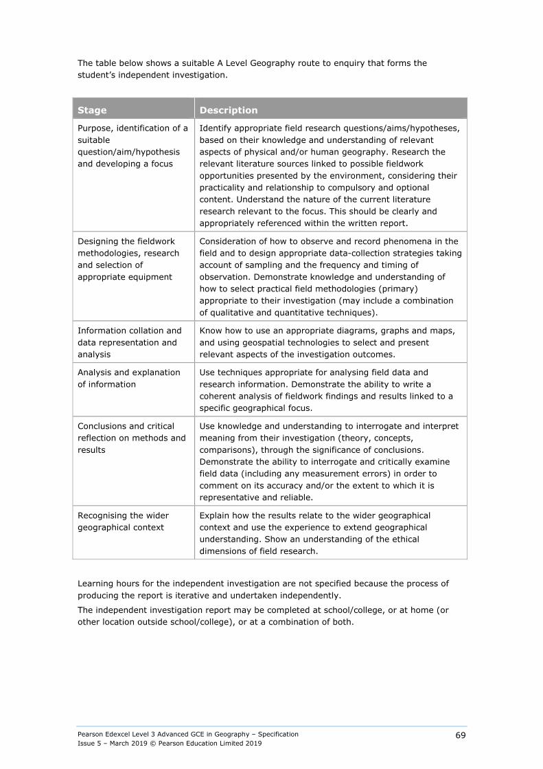
Pearson Edexcel Level 3 Advanced GCE in Geography – Specification Issue 5 – March 2019 © Pearson Education Limited 2019
69
The table below shows a suitable A Level Geography route to enquiry that forms the student’s independent investigation.
Stage Description
Purpose, identification of a suitable question/aim/hypothesis and developing a focus
Identify appropriate field research questions/aims/hypotheses, based on their knowledge and understanding of relevant aspects of physical and/or human geography. Research the relevant literature sources linked to possible fieldwork opportunities presented by the environment, considering their practicality and relationship to compulsory and optional content. Understand the nature of the current literature research relevant to the focus. This should be clearly and appropriately referenced within the written report.
Designing the fieldwork methodologies, research and selection of appropriate equipment
Consideration of how to observe and record phenomena in the field and to design appropriate data-collection strategies taking account of sampling and the frequency and timing of observation. Demonstrate knowledge and understanding of how to select practical field methodologies (primary) appropriate to their investigation (may include a combination of qualitative and quantitative techniques).
Information collation and data representation and analysis
Know how to use an appropriate diagrams, graphs and maps, and using geospatial technologies to select and present relevant aspects of the investigation outcomes.
Analysis and explanation of information
Use techniques appropriate for analysing field data and research information. Demonstrate the ability to write a coherent analysis of fieldwork findings and results linked to a specific geographical focus.
Conclusions and critical reflection on methods and results
Use knowledge and understanding to interrogate and interpret meaning from their investigation (theory, concepts, comparisons), through the significance of conclusions. Demonstrate the ability to interrogate and critically examine field data (including any measurement errors) in order to comment on its accuracy and/or the extent to which it is representative and reliable.
Recognising the wider geographical context
Explain how the results relate to the wider geographical context and use the experience to extend geographical understanding. Show an understanding of the ethical dimensions of field research.
Learning hours for the independent investigation are not specified because the process of producing the report is iterative and undertaken independently.
The independent investigation report may be completed at school/college, or at home (or other location outside school/college), or at a combination of both.
Pearson Edexcel Level 3 Advanced GCE in Geography – Specification Issue 5 – March 2019 © Pearson Education Limited 2019
70
Independent Investigation controls relating to student independence and teacher guidance to students The rationale for the following rules is given in Appendix 13.
Guidance permitted at different stages: ● Investigation title stage (guidance and approval) ● Planning and investigation stage (guidance and approval)
Teachers:
Can: ● provide broad parameters for candidates’ investigation proposals (including themes from
the specification, locations, availability of equipment, time constraints); ● explain what independence means (see table in Appendix 6). ● advise on health and safety considerations, the use of equipment and potential ethical
concerns. ● discuss with candidates their initial exploratory planning and tentative investigation titles.
Must: ● confirm that the provisional title has the potential to meet the assessment criteria and
offer general guidance on any necessary amendments. ● review each candidate’s Geography Independent Investigation Form. Within this review
teachers should ensure that the proposed investigation can suitably access the specification requirements and give general guidance on the methodology and analytical tools that the candidate plans to use.
● promote good practice such as referencing and using a bibliography system. ● store work securely once it is handed in for formal assessment.
Must not2: ● provide candidates with a choice of titles or tasks from which candidates then choose. ● give detailed feedback to individual candidates about how to improve work to meet the
assessment criteria. The guidance provided prior to final submission should only enable candidates to take the initiative in making amendments, rather than detailing what amendments should be made. This means that teachers must not provide templates and model answers for the work of specific candidates.
● mark work provisionally and share that mark so that the candidate may then improve it. ● return work to candidates after it has been submitted and marked. ● give guidance on how to make improvements to the draft in order to meet the assessment
criteria so that candidates are no longer engaged in independent learning.
2 This section applies also to third party fieldwork providers. Teachers must ensure that at all times they remain confident in the authenticity and independence of the candidate’s work.
Pearson Edexcel Level 3 Advanced GCE in Geography – Specification Issue 5 – March 2019 © Pearson Education Limited 2019
71
If teachers give any assistance which goes beyond general advice, for example3: ● provide detailed specific guidance on how to improve drafts to meet the assessment
criteria; ● give detailed specific guidance on errors and omissions which limits candidates’
opportunities to show initiative themselves; ● intervene personally to improve the presentation or content of work; ● provide primary or secondary data not collected by the candidate either individually or as
part of a group
then they must record this assistance and take it into account when marking the work.
Annotation should be used to explain how marks were applied in the context of the additional assistance given.
If teachers and/or third party fieldwork providers give specific guidance which goes beyond general guidance and do not take it into account when marking the work, or record it, this will be considered as malpractice. If malpractice is suspected, the Awarding Organisation will investigate. If malpractice is found to have taken place a penalty will be applied dependent on the circumstances and severity of the malpractice.
For full information regarding malpractice please see the JCQ document ‘Suspected Malpractice in Examinations and Assessments’.
Examples of specific guidance and general guidance are given in Appendix 14, page 117. These examples are not exhaustive.
Description of the level of independence at each stage of the investigation
Appendix 6 gives descriptions which, although they do not infer anything in the way of marks allocated for each stage of the investigation, are to specify the level of independence required at different stages.
Note that the level of independence at each stage is the minimum required (i.e. where collaboration is allowed it is not mandatory and candidates may work alone).
Levels of independence: ● Collaboration allowed - candidates may work as a class/group/pair, ● Independent work – candidates must work alone
If candidates collaborate (where independence is expected) and/or are given assistance beyond the parameters indicated in the table below, then the teacher must record this on the Geography Independent Investigation Form and take it into account when marking the work. Failure to do so will be considered as malpractice. If malpractice is suspected the Awarding Organisation will investigate. If malpractice is found to have taken place a penalty will be given dependent on the circumstances and severity of the malpractice.
For full information regarding malpractice please see the JCQ document ‘Suspected Malpractice in Examinations and Assessments’.
Health and safety All centres must comply with the new requirements (2011) of relevant legislation and codes of practice, including the Department for Education health and safety guidance for schools (www.education.gov.uk/schools/adminandfinance/healthandssafety) and the Health and Safety Executive – School trips and outdoor learning activities (www.hse.gov.uk/services/education/school-trips.pdf).
3 First three bullet points as per the JCQ Instructions for conducting non-examination assessment, section 4.2.
Pearson Edexcel Level 3 Advanced GCE in Geography – Specification Issue 5 – March 2019 © Pearson Education Limited 2019
72
Centres should also develop their own mechanisms so that students know the importance of ensuring their own safety and that of others. This could include developing risk assessments as part of the preparation for fieldwork, for example by using Google Maps and Google StreetView to assess likely hazards and risk. Students who might be lone working should be provided with additional information and guidance and the centre must have suitable policies and procedures for lone working.
Resources Students must have equal access to IT resources. Students should have access to a range of resources, literature and texts to enable them to make choices as required for their research task.
Storing students’ work Where students are completing the assignment over a number of sessions, at the end of each session their work must be saved and kept securely.
Word count It is recommended that students write between 3000 and 4000 words for their independent investigation. Students will not be specifically penalised on the basis of the length of their written report. However, excessively high or low word counts may restrict students’ ability to evidence the skills outlined in the marking criteria. Students must sign the candidate declaration in both the Geography independent investigation form (Appendix 5) and Mark sheet (Appendix 7).
Submission of the independent investigation report The student’s completed individual investigation report should be submitted to Pearson. The original Non-examination assessment Authentication Sheet must be included.
Independent Investigation plan guidance service Pearson provides a free student planning guidance service. Please see our website for further details.
Pearson Edexcel Level 3 Advanced GCE in Geography – Specification Issue 5 – March 2019 © Pearson Education Limited 2019
73
Assessment, internal standardisation and moderation Candidates’ investigations must be internally-assessed by centres, annotated to indicate how and why marks have been awarded, and internally-standardised, following the procedures specified in section 6.1 and 6.2 of the JCQ Instructions for conducting non-exam assessments. The independent investigation is then externally moderated. There is a maximum of 70 marks available for the independent investigation. Teachers should mark the independent investigation using the assessment criteria on the following pages. Teachers may annotate students’ work but should also include any comments on the Geography independent investigation form (see Appendix 5) to justify the marks awarded.
Where marking has been carried out by more than one teacher in a centre, there must be a process of internal standardisation carried out to ensure that there is a consistent application of the assessment criteria.
Marks awarded by the centre will be subject to external moderation by Pearson. Moderation will ensure consistency with national standards and will include a review of assignments to ensure that the assignment-setting rules have been correctly applied by centres. Pearson will notify centres of the students whose work has been selected for moderation. This sample will take cohort size into account.
If the moderation indicates that centre assessment does not reflect national standards, an adjustment will be made to students’ final marks to compensate.
For further information please refer to the Joint Council for Qualifications (JCQ) Instructions for Conducting Non-examined Assessments on the JCQ website: www.jcq.org.uk. The assessment of this qualification must comply with these instructions.
Non-examination assessment assessment criteria Teachers must mark students’ work using the following assessment criteria.
Marking guidance
● All students must receive the same treatment. Teachers must mark the last student in exactly the same way as they mark the first.
● The assessment criteria descriptors should be used to assess which mark range students work best fits. When this has been determined, a decision must be taken on whether the work is placed at the ‘bottom’, ‘middle’ or ‘top’ of this mark range. A mark can then be confidently awarded.
● Mark schemes should be applied positively. Students must be rewarded for what they have shown they can do rather than be penalised for omissions.
● All the marks on the mark scheme are designed to be awarded. Teachers should always award full marks if deserved, i.e. if the answer matches the mark scheme. Teachers should be prepared to award zero marks if the student’s response is not worthy of credit according to the mark scheme.
● Centres must internally moderate and cross-standardise work to ensure fairness, accuracy and reliability.

Pearson Edexcel Level 3 Advanced GCE in Geography – Specification Issue 5 – March 2019 © Pearson Education Limited 2019
74
Purpose of the Independent Investigation (12 marks) (AO1: 4 marks, AO2: 4 marks and AO 3: 4 marks)
Level Mark Descriptor
0 No rewardable material.
Level 1 1–4 ● Demonstrates isolated elements of geographical knowledge and understanding of location, geographical theory and comparative context, which are frequently irrelevant or inaccurate. (AO1)
● May attempt to apply understanding to find links between the investigation’s context and a broader geographical context but links are irrelevant with frequent inaccuracies. (AO2)
● May attempt to investigate frequently irrelevant and narrow range of geographical sources in order to identify/obtain geographical information and data that is frequently inaccurate and only occasionally supports the investigation; the aim, question or hypothesis is generic or unlinked to research information, and provides an unfocused framework for investigation, with flawed consideration of manageability and/or scale; planned enquiry process is limited in clarity and structure. (AO3)
Level 2 5–8 ● Demonstrates geographical knowledge and understanding of location, geographical theory and comparative context which is relevant but narrow or incomplete, and may include some inaccuracies. (AO1)
● Applies understanding to find links between the investigation’s context and a broader geographical context; links are mainly relevant and coherent but may include some inaccuracies. (AO2)
● Investigates a range of mainly relevant geographical sources in order to identify/obtain mainly accurate geographical information and data that supports most parts of the investigation; research information is used to construct a generally valid aim, question or hypothesis that provides a mostly appropriate framework for investigation with some consideration of manageability and/or scale; planned enquiry process is adequately structured and clear. (AO3)
Level 3 9–12 ● Demonstrates accurate and relevant geographical knowledge and understanding of location, geographical theory and comparative context throughout. (AO1)
● Applies understanding to find coherent and relevant links between the investigation’s context and a broader geographical context. (AO2)
● Investigates a wide range of relevant geographical sources in order to identify/obtain accurate geographical information and data that support the investigation; research information is used to construct a justified aim, question or hypothesis that provides an appropriate framework for investigation at a manageable scale; planned enquiry process is logically structured and comprehensive. (AO3)
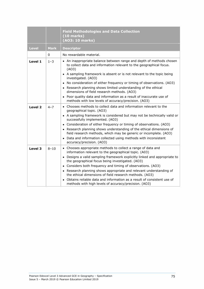
Pearson Edexcel Level 3 Advanced GCE in Geography – Specification Issue 5 – March 2019 © Pearson Education Limited 2019
75
Field Methodologies and Data Collection (10 marks) (AO3: 10 marks)
Level Mark Descriptor
0 No rewardable material.
Level 1 1–3 ● An inappropriate balance between range and depth of methods chosen to collect data and information relevant to the geographical focus. (AO3)
● A sampling framework is absent or is not relevant to the topic being investigated. (AO3)
● No consideration of either frequency or timing of observations. (AO3) ● Research planning shows limited understanding of the ethical
dimensions of field research methods. (AO3) ● Poor quality data and information as a result of inaccurate use of
methods with low levels of accuracy/precision. (AO3)
Level 2 4–7 ● Chooses methods to collect data and information relevant to the geographical topic. (AO3)
● A sampling framework is considered but may not be technically valid or successfully implemented. (AO3)
● Consideration of either frequency or timing of observations. (AO3) ● Research planning shows understanding of the ethical dimensions of
field research methods, which may be generic or incomplete. (AO3) ● Data and information collected using methods with inconsistent
accuracy/precision. (AO3)
Level 3 8–10 ● Chooses appropriate methods to collect a range of data and information relevant to the geographical topic. (A03)
● Designs a valid sampling framework explicitly linked and appropriate to the geographical focus being investigated. (AO3)
● Considers both frequency and timing of observations. (AO3) ● Research planning shows appropriate and relevant understanding of
the ethical dimensions of field research methods. (AO3) ● Obtains reliable data and information as a result of consistent use of
methods with high levels of accuracy/precision. (AO3)
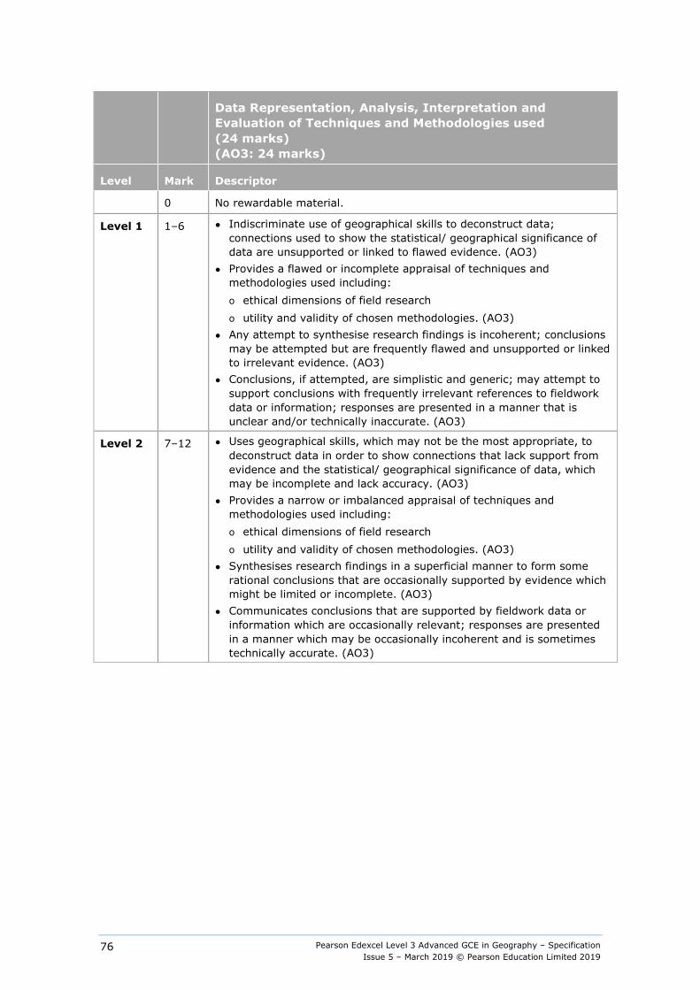
Pearson Edexcel Level 3 Advanced GCE in Geography – Specification Issue 5 – March 2019 © Pearson Education Limited 2019
76
Data Representation, Analysis, Interpretation and Evaluation of Techniques and Methodologies used (24 marks) (AO3: 24 marks)
Level Mark Descriptor
0 No rewardable material.
Level 1 1–6 ● Indiscriminate use of geographical skills to deconstruct data; connections used to show the statistical/ geographical significance of data are unsupported or linked to flawed evidence. (AO3)
● Provides a flawed or incomplete appraisal of techniques and methodologies used including: o ethical dimensions of field research o utility and validity of chosen methodologies. (AO3)
● Any attempt to synthesise research findings is incoherent; conclusions may be attempted but are frequently flawed and unsupported or linked to irrelevant evidence. (AO3)
● Conclusions, if attempted, are simplistic and generic; may attempt to support conclusions with frequently irrelevant references to fieldwork data or information; responses are presented in a manner that is unclear and/or technically inaccurate. (AO3)
Level 2 7–12 ● Uses geographical skills, which may not be the most appropriate, to deconstruct data in order to show connections that lack support from evidence and the statistical/ geographical significance of data, which may be incomplete and lack accuracy. (AO3)
● Provides a narrow or imbalanced appraisal of techniques and methodologies used including: o ethical dimensions of field research o utility and validity of chosen methodologies. (AO3)
● Synthesises research findings in a superficial manner to form some rational conclusions that are occasionally supported by evidence which might be limited or incomplete. (AO3)
● Communicates conclusions that are supported by fieldwork data or information which are occasionally relevant; responses are presented in a manner which may be occasionally incoherent and is sometimes technically accurate. (AO3)
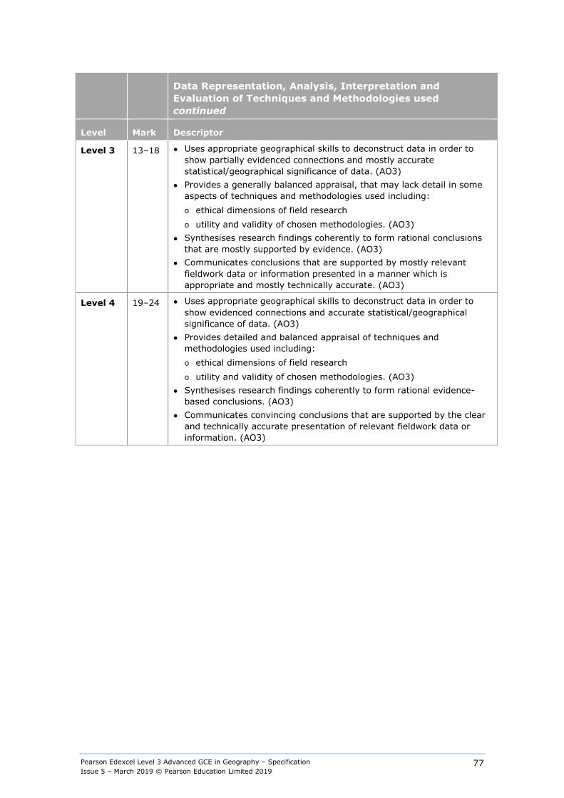
Pearson Edexcel Level 3 Advanced GCE in Geography – Specification Issue 5 – March 2019 © Pearson Education Limited 2019
77
Data Representation, Analysis, Interpretation and Evaluation of Techniques and Methodologies used continued
Level Mark Descriptor
Level 3 13–18 ● Uses appropriate geographical skills to deconstruct data in order to show partially evidenced connections and mostly accurate statistical/geographical significance of data. (AO3)
● Provides a generally balanced appraisal, that may lack detail in some aspects of techniques and methodologies used including: o ethical dimensions of field research o utility and validity of chosen methodologies. (AO3)
● Synthesises research findings coherently to form rational conclusions that are mostly supported by evidence. (AO3)
● Communicates conclusions that are supported by mostly relevant fieldwork data or information presented in a manner which is appropriate and mostly technically accurate. (AO3)
Level 4 19–24 ● Uses appropriate geographical skills to deconstruct data in order to show evidenced connections and accurate statistical/geographical significance of data. (AO3)
● Provides detailed and balanced appraisal of techniques and methodologies used including: o ethical dimensions of field research o utility and validity of chosen methodologies. (AO3)
● Synthesises research findings coherently to form rational evidence-based conclusions. (AO3)
● Communicates convincing conclusions that are supported by the clear and technically accurate presentation of relevant fieldwork data or information. (AO3)
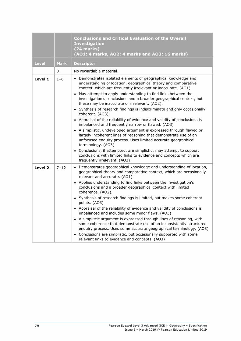
Pearson Edexcel Level 3 Advanced GCE in Geography – Specification Issue 5 – March 2019 © Pearson Education Limited 2019
78
Conclusions and Critical Evaluation of the Overall Investigation (24 marks) (AO1: 4 marks, AO2: 4 marks and AO3: 16 marks)
Level Mark Descriptor
0 No rewardable material.
Level 1 1–6 ● Demonstrates isolated elements of geographical knowledge and understanding of location, geographical theory and comparative context, which are frequently irrelevant or inaccurate. (AO1)
● May attempt to apply understanding to find links between the investigation’s conclusions and a broader geographical context, but these may be inaccurate or irrelevant. (AO2).
● Synthesis of research findings is indiscriminate and only occasionally coherent. (AO3)
● Appraisal of the reliability of evidence and validity of conclusions is imbalanced and frequently narrow or flawed. (AO3)
● A simplistic, undeveloped argument is expressed through flawed or largely incoherent lines of reasoning that demonstrate use of an unfocused enquiry process. Uses limited accurate geographical terminology. (AO3)
● Conclusions, if attempted, are simplistic; may attempt to support conclusions with limited links to evidence and concepts which are frequently irrelevant. (AO3)
Level 2 7–12 ● Demonstrates geographical knowledge and understanding of location, geographical theory and comparative context, which are occasionally relevant and accurate. (AO1)
● Applies understanding to find links between the investigation’s conclusions and a broader geographical context with limited coherence. (AO2).
● Synthesis of research findings is limited, but makes some coherent points. (AO3)
● Appraisal of the reliability of evidence and validity of conclusions is imbalanced and includes some minor flaws. (AO3)
● A simplistic argument is expressed through lines of reasoning, with some coherence that demonstrate use of an inconsistently structured enquiry process. Uses some accurate geographical terminology. (AO3)
● Conclusions are simplistic, but occasionally supported with some relevant links to evidence and concepts. (AO3)
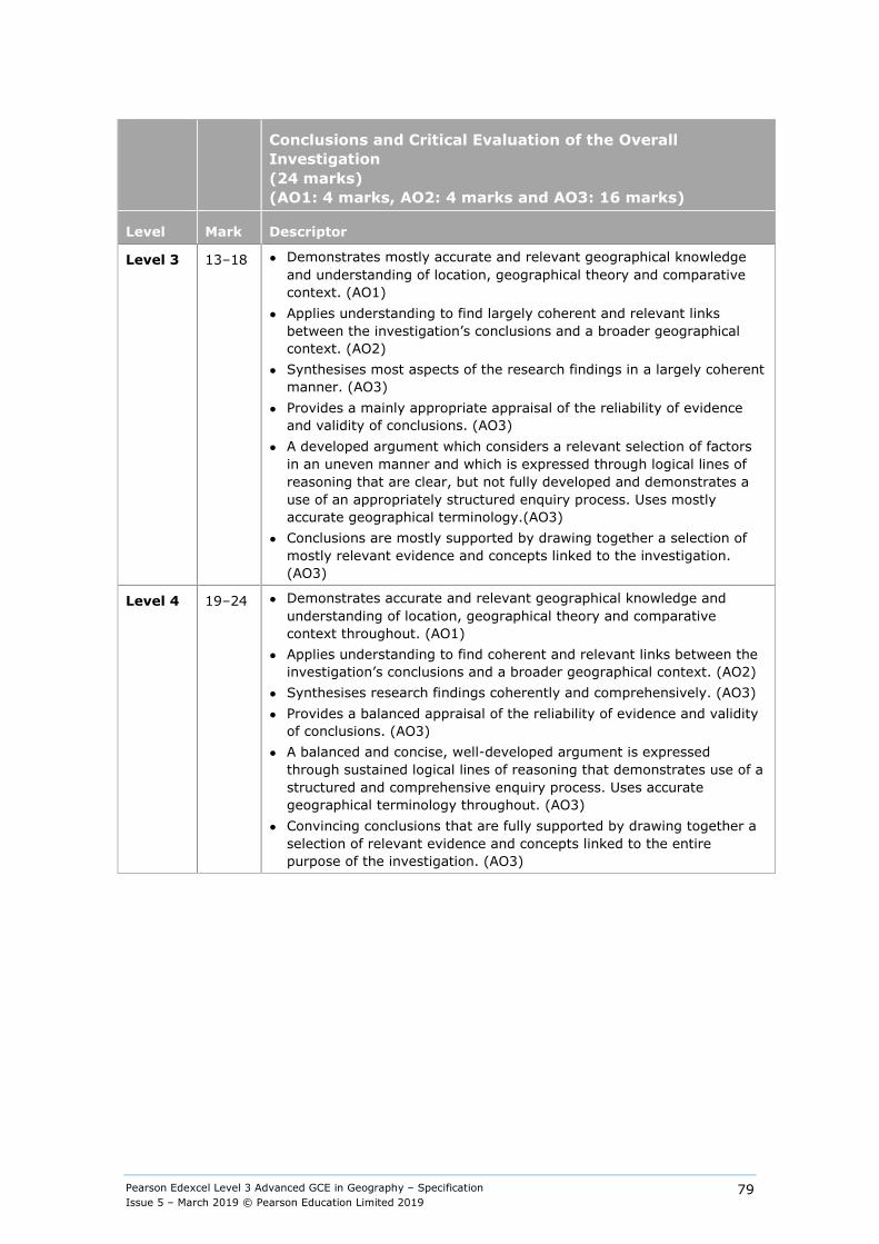
Pearson Edexcel Level 3 Advanced GCE in Geography – Specification Issue 5 – March 2019 © Pearson Education Limited 2019
79
Conclusions and Critical Evaluation of the Overall Investigation (24 marks) (AO1: 4 marks, AO2: 4 marks and AO3: 16 marks)
Level Mark Descriptor
Level 3 13–18 ● Demonstrates mostly accurate and relevant geographical knowledge and understanding of location, geographical theory and comparative context. (AO1)
● Applies understanding to find largely coherent and relevant links between the investigation’s conclusions and a broader geographical context. (AO2)
● Synthesises most aspects of the research findings in a largely coherent manner. (AO3)
● Provides a mainly appropriate appraisal of the reliability of evidence and validity of conclusions. (AO3)
● A developed argument which considers a relevant selection of factors in an uneven manner and which is expressed through logical lines of reasoning that are clear, but not fully developed and demonstrates a use of an appropriately structured enquiry process. Uses mostly accurate geographical terminology.(AO3)
● Conclusions are mostly supported by drawing together a selection of mostly relevant evidence and concepts linked to the investigation. (AO3)
Level 4 19–24 ● Demonstrates accurate and relevant geographical knowledge and understanding of location, geographical theory and comparative context throughout. (AO1)
● Applies understanding to find coherent and relevant links between the investigation’s conclusions and a broader geographical context. (AO2)
● Synthesises research findings coherently and comprehensively. (AO3) ● Provides a balanced appraisal of the reliability of evidence and validity
of conclusions. (AO3) ● A balanced and concise, well-developed argument is expressed
through sustained logical lines of reasoning that demonstrates use of a structured and comprehensive enquiry process. Uses accurate geographical terminology throughout. (AO3)
● Convincing conclusions that are fully supported by drawing together a selection of relevant evidence and concepts linked to the entire purpose of the investigation. (AO3)
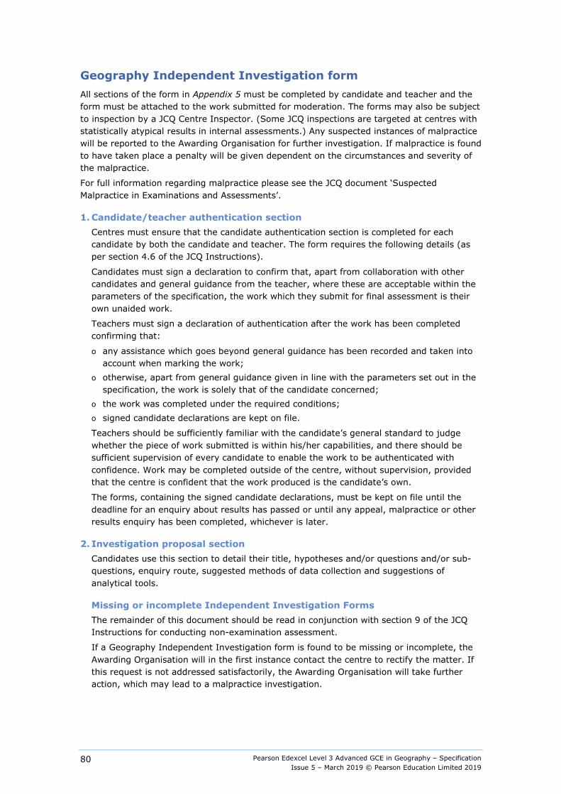
Pearson Edexcel Level 3 Advanced GCE in Geography – Specification Issue 5 – March 2019 © Pearson Education Limited 2019
80
Geography Independent Investigation form All sections of the form in Appendix 5 must be completed by candidate and teacher and the form must be attached to the work submitted for moderation. The forms may also be subject to inspection by a JCQ Centre Inspector. (Some JCQ inspections are targeted at centres with statistically atypical results in internal assessments.) Any suspected instances of malpractice will be reported to the Awarding Organisation for further investigation. If malpractice is found to have taken place a penalty will be given dependent on the circumstances and severity of the malpractice.
For full information regarding malpractice please see the JCQ document ‘Suspected Malpractice in Examinations and Assessments’.
1. Candidate/teacher authentication section Centres must ensure that the candidate authentication section is completed for each
candidate by both the candidate and teacher. The form requires the following details (as per section 4.6 of the JCQ Instructions).
Candidates must sign a declaration to confirm that, apart from collaboration with other candidates and general guidance from the teacher, where these are acceptable within the parameters of the specification, the work which they submit for final assessment is their own unaided work.
Teachers must sign a declaration of authentication after the work has been completed confirming that:
o any assistance which goes beyond general guidance has been recorded and taken into account when marking the work;
o otherwise, apart from general guidance given in line with the parameters set out in the specification, the work is solely that of the candidate concerned;
o the work was completed under the required conditions; o signed candidate declarations are kept on file.
Teachers should be sufficiently familiar with the candidate’s general standard to judge whether the piece of work submitted is within his/her capabilities, and there should be sufficient supervision of every candidate to enable the work to be authenticated with confidence. Work may be completed outside of the centre, without supervision, provided that the centre is confident that the work produced is the candidate’s own.
The forms, containing the signed candidate declarations, must be kept on file until the deadline for an enquiry about results has passed or until any appeal, malpractice or other results enquiry has been completed, whichever is later.
2. Investigation proposal section Candidates use this section to detail their title, hypotheses and/or questions and/or sub-questions, enquiry route, suggested methods of data collection and suggestions of analytical tools.
Missing or incomplete Independent Investigation Forms The remainder of this document should be read in conjunction with section 9 of the JCQ Instructions for conducting non-examination assessment.
If a Geography Independent Investigation form is found to be missing or incomplete, the Awarding Organisation will in the first instance contact the centre to rectify the matter. If this request is not addressed satisfactorily, the Awarding Organisation will take further action, which may lead to a malpractice investigation.
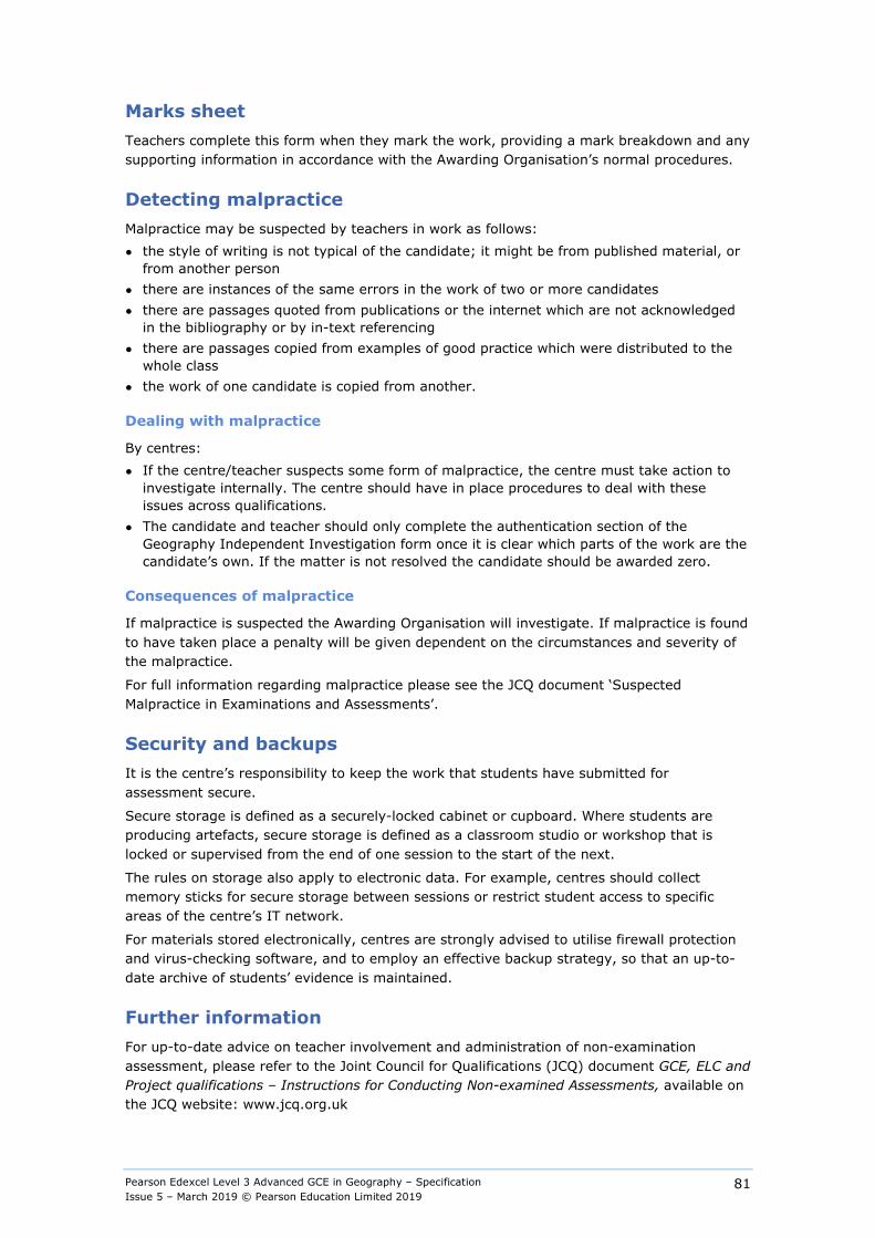
Pearson Edexcel Level 3 Advanced GCE in Geography – Specification Issue 5 – March 2019 © Pearson Education Limited 2019
81
Marks sheet Teachers complete this form when they mark the work, providing a mark breakdown and any supporting information in accordance with the Awarding Organisation’s normal procedures.
Detecting malpractice Malpractice may be suspected by teachers in work as follows: ● the style of writing is not typical of the candidate; it might be from published material, or
from another person ● there are instances of the same errors in the work of two or more candidates ● there are passages quoted from publications or the internet which are not acknowledged
in the bibliography or by in-text referencing ● there are passages copied from examples of good practice which were distributed to the
whole class ● the work of one candidate is copied from another.
Dealing with malpractice
By centres: ● If the centre/teacher suspects some form of malpractice, the centre must take action to
investigate internally. The centre should have in place procedures to deal with these issues across qualifications.
● The candidate and teacher should only complete the authentication section of the Geography Independent Investigation form once it is clear which parts of the work are the candidate’s own. If the matter is not resolved the candidate should be awarded zero.
Consequences of malpractice
If malpractice is suspected the Awarding Organisation will investigate. If malpractice is found to have taken place a penalty will be given dependent on the circumstances and severity of the malpractice.
For full information regarding malpractice please see the JCQ document ‘Suspected Malpractice in Examinations and Assessments’.
Security and backups It is the centre’s responsibility to keep the work that students have submitted for assessment secure.
Secure storage is defined as a securely-locked cabinet or cupboard. Where students are producing artefacts, secure storage is defined as a classroom studio or workshop that is locked or supervised from the end of one session to the start of the next.
The rules on storage also apply to electronic data. For example, centres should collect memory sticks for secure storage between sessions or restrict student access to specific areas of the centre’s IT network.
For materials stored electronically, centres are strongly advised to utilise firewall protection and virus-checking software, and to employ an effective backup strategy, so that an up-to-date archive of students’ evidence is maintained.
Further information For up-to-date advice on teacher involvement and administration of non-examination assessment, please refer to the Joint Council for Qualifications (JCQ) document GCE, ELC and Project qualifications – Instructions for Conducting Non-examined Assessments, available on the JCQ website: www.jcq.org.uk
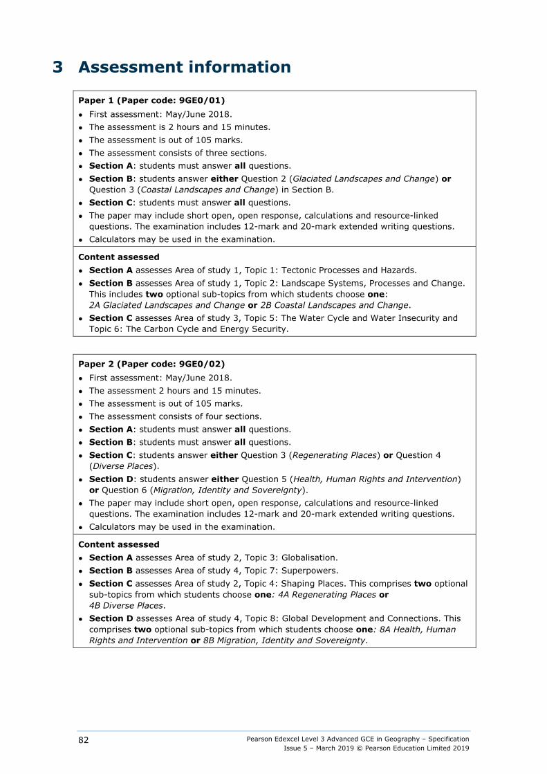
Pearson Edexcel Level 3 Advanced GCE in Geography – Specification Issue 5 – March 2019 © Pearson Education Limited 2019
82
3 Assessment information
Paper 1 (Paper code: 9GE0/01) ● First assessment: May/June 2018. ● The assessment is 2 hours and 15 minutes. ● The assessment is out of 105 marks. ● The assessment consists of three sections. ● Section A: students must answer all questions. ● Section B: students answer either Question 2 (Glaciated Landscapes and Change) or
Question 3 (Coastal Landscapes and Change) in Section B. ● Section C: students must answer all questions. ● The paper may include short open, open response, calculations and resource-linked
questions. The examination includes 12-mark and 20-mark extended writing questions. ● Calculators may be used in the examination.
Content assessed ● Section A assesses Area of study 1, Topic 1: Tectonic Processes and Hazards. ● Section B assesses Area of study 1, Topic 2: Landscape Systems, Processes and Change.
This includes two optional sub-topics from which students choose one: 2A Glaciated Landscapes and Change or 2B Coastal Landscapes and Change.
● Section C assesses Area of study 3, Topic 5: The Water Cycle and Water Insecurity and Topic 6: The Carbon Cycle and Energy Security.
Paper 2 (Paper code: 9GE0/02) ● First assessment: May/June 2018. ● The assessment 2 hours and 15 minutes. ● The assessment is out of 105 marks. ● The assessment consists of four sections. ● Section A: students must answer all questions. ● Section B: students must answer all questions. ● Section C: students answer either Question 3 (Regenerating Places) or Question 4
(Diverse Places). ● Section D: students answer either Question 5 (Health, Human Rights and Intervention)
or Question 6 (Migration, Identity and Sovereignty). ● The paper may include short open, open response, calculations and resource-linked
questions. The examination includes 12-mark and 20-mark extended writing questions. ● Calculators may be used in the examination.
Content assessed ● Section A assesses Area of study 2, Topic 3: Globalisation. ● Section B assesses Area of study 4, Topic 7: Superpowers. ● Section C assesses Area of study 2, Topic 4: Shaping Places. This comprises two optional
sub-topics from which students choose one: 4A Regenerating Places or 4B Diverse Places.
● Section D assesses Area of study 4, Topic 8: Global Development and Connections. This comprises two optional sub-topics from which students choose one: 8A Health, Human Rights and Intervention or 8B Migration, Identity and Sovereignty.
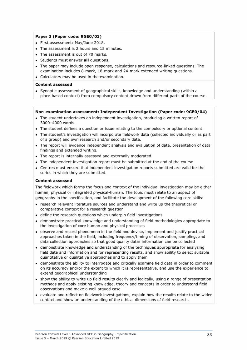
Pearson Edexcel Level 3 Advanced GCE in Geography – Specification Issue 5 – March 2019 © Pearson Education Limited 2019
83
Paper 3 (Paper code: 9GE0/03) ● First assessment: May/June 2018. ● The assessment is 2 hours and 15 minutes. ● The assessment is out of 70 marks. ● Students must answer all questions. ● The paper may include open response, calculations and resource-linked questions. The
examination includes 8-mark, 18-mark and 24-mark extended writing questions. ● Calculators may be used in the examination.
Content assessed ● Synoptic assessment of geographical skills, knowledge and understanding (within a
place-based context) from compulsory content drawn from different parts of the course.
Non-examination assessment: Independent Investigation (Paper code: 9GE0/04) ● The student undertakes an independent investigation, producing a written report of
3000–4000 words. ● The student defines a question or issue relating to the compulsory or optional content. ● The student’s investigation will incorporate fieldwork data (collected individually or as part
of a group) and own research and/or secondary data. ● The report will evidence independent analysis and evaluation of data, presentation of data
findings and extended writing. ● The report is internally assessed and externally moderated. ● The independent investigation report must be submitted at the end of the course. ● Centres must ensure that independent investigation reports submitted are valid for the
series in which they are submitted.
Content assessed The fieldwork which forms the focus and context of the individual investigation may be either human, physical or integrated physical-human. The topic must relate to an aspect of geography in the specification, and facilitate the development of the following core skills:
● research relevant literature sources and understand and write up the theoretical or comparative context for a research question
● define the research questions which underpin field investigations ● demonstrate practical knowledge and understanding of field methodologies appropriate to
the investigation of core human and physical processes ● observe and record phenomena in the field and devise, implement and justify practical
approaches taken in the field, including frequency/timing of observation, sampling, and data collection approaches so that good quality data/ information can be collected
● demonstrate knowledge and understanding of the techniques appropriate for analysing field data and information and for representing results, and show ability to select suitable quantitative or qualitative approaches and to apply them
● demonstrate the ability to interrogate and critically examine field data in order to comment on its accuracy and/or the extent to which it is representative, and use the experience to extend geographical understanding
● show the ability to write up field results clearly and logically, using a range of presentation methods and apply existing knowledge, theory and concepts in order to understand field observations and make a well argued case
● evaluate and reflect on fieldwork investigations, explain how the results relate to the wider context and show an understanding of the ethical dimensions of field research.
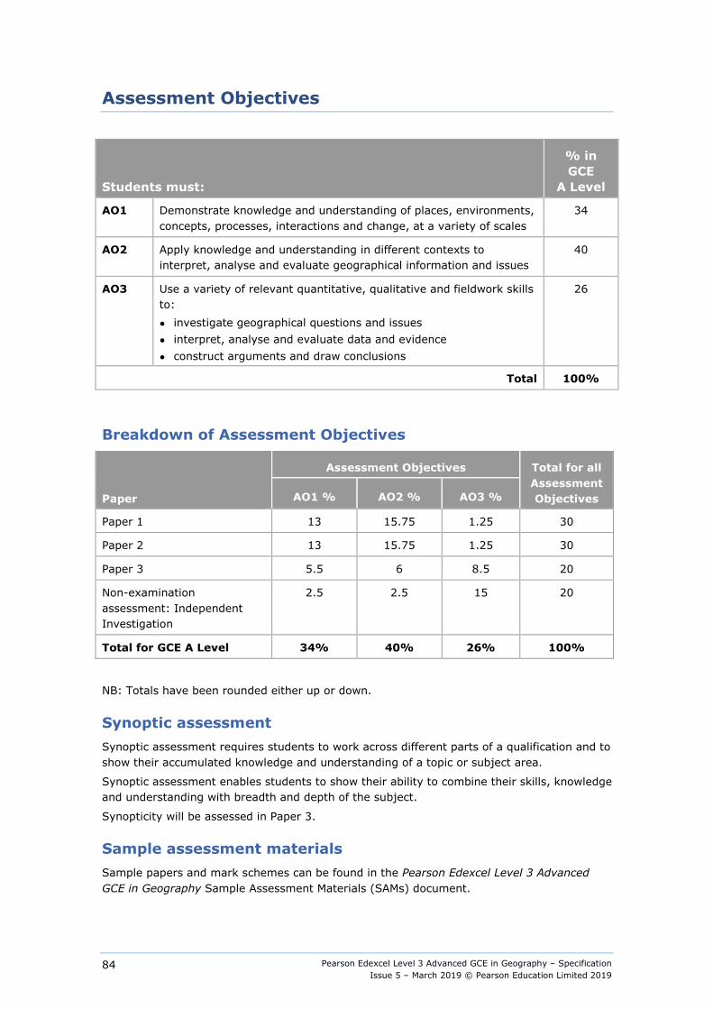
Pearson Edexcel Level 3 Advanced GCE in Geography – Specification Issue 5 – March 2019 © Pearson Education Limited 2019
84
Assessment Objectives
Students must:
% in GCE
A Level
AO1 Demonstrate knowledge and understanding of places, environments, concepts, processes, interactions and change, at a variety of scales
34
AO2 Apply knowledge and understanding in different contexts to interpret, analyse and evaluate geographical information and issues
40
AO3 Use a variety of relevant quantitative, qualitative and fieldwork skills to: ● investigate geographical questions and issues ● interpret, analyse and evaluate data and evidence ● construct arguments and draw conclusions
26
Total 100%
Breakdown of Assessment Objectives
Paper
Assessment Objectives Total for all Assessment Objectives AO1 % AO2 % AO3 %
Paper 1 13 15.75 1.25 30
Paper 2 13 15.75 1.25 30
Paper 3 5.5 6 8.5 20
Non-examination assessment: Independent Investigation
2.5 2.5 15 20
Total for GCE A Level 34% 40% 26% 100%
NB: Totals have been rounded either up or down.
Synoptic assessment Synoptic assessment requires students to work across different parts of a qualification and to show their accumulated knowledge and understanding of a topic or subject area.
Synoptic assessment enables students to show their ability to combine their skills, knowledge and understanding with breadth and depth of the subject.
Synopticity will be assessed in Paper 3.
Sample assessment materials Sample papers and mark schemes can be found in the Pearson Edexcel Level 3 Advanced GCE in Geography Sample Assessment Materials (SAMs) document.
Pearson Edexcel Level 3 Advanced GCE in Geography – Specification Issue 5 – March 2019 © Pearson Education Limited 2019
85
4 Administration and general information
Entries Details of how to enter students for the examinations for this qualification can be found in our UK Information Manual. A copy is made available to all examinations officers and is available on our website: qualifications.pearson.com
Discount code and performance tables Centres should be aware that students who enter for more than one GCE qualification with the same discount code will have only one of the grades they achieve counted for the purpose of the school and college performance tables. This will be the grade for the larger qualification (i.e. the A Level grade rather than the AS grade). If the qualifications are the same size, then the better grade will be counted (please see Appendix 12: Codes).
Students should be advised that if they take two GCE qualifications with the same discount code, colleges, universities and employers they wish to progress to are likely to take the view that this achievement is equivalent to only one GCE. The same view may be taken if students take two GCE qualifications that have different discount codes but have significant overlap of content. Students or their advisers who have any doubts about their subject combinations should check with the institution they wish to progress to before embarking on their programmes.
Access arrangements, reasonable adjustments, special consideration and malpractice Equality and fairness are central to our work. Our equality policy requires all students to have equal opportunity to access our qualifications and assessments, and our qualifications to be awarded in a way that is fair to every student.
We are committed to making sure that: ● students with a protected characteristic (as defined by the Equality Act 2010) are not,
when they are undertaking one of our qualifications, disadvantaged in comparison to students who do not share that characteristic
● all students achieve the recognition they deserve for undertaking a qualification and that this achievement can be compared fairly to the achievement of their peers.
Language of assessment Assessment of this qualification will be available in English. All student work must be in English.
Access arrangements Access arrangements are agreed before an assessment. They allow students with special educational needs, disabilities or temporary injuries to: ● access the assessment ● show what they know and can do without changing the demands of the assessment.
Pearson Edexcel Level 3 Advanced GCE in Geography – Specification Issue 5 – March 2019 © Pearson Education Limited 2019
86
The intention behind an access arrangement is to meet the particular needs of an individual student with a disability, without affecting the integrity of the assessment. Access arrangements are the principal way in which awarding bodies comply with the duty under the Equality Act 2010 to make ‘reasonable adjustments’.
Access arrangements should always be processed at the start of the course. Students will then know what is available and have the access arrangement(s) in place for assessment.
Reasonable adjustments The Equality Act 2010 requires an awarding organisation to make reasonable adjustments where a person with a disability would be at a substantial disadvantage in undertaking an assessment. The awarding organisation is required to take reasonable steps to overcome that disadvantage.
A reasonable adjustment for a particular person may be unique to that individual and therefore might not be in the list of available access arrangements.
Whether an adjustment will be considered reasonable will depend on a number of factors, which will include: ● the needs of the student with the disability ● the effectiveness of the adjustment ● the cost of the adjustment; and ● the likely impact of the adjustment on the student with the disability and other students.
An adjustment will not be approved if it involves unreasonable costs to the awarding organisation, timeframes or affects the security or integrity of the assessment. This is because the adjustment is not ‘reasonable’.
Special consideration Special consideration is a post-examination adjustment to a student's mark or grade to reflect temporary injury, illness or other indisposition at the time of the examination/ assessment, which has had, or is reasonably likely to have had, a material effect on a candidate’s ability to take an assessment or demonstrate their level of attainment in an assessment.
Further information Please see our website for further information about how to apply for access arrangements and special consideration.
For further information about access arrangements, reasonable adjustments and special consideration, please refer to the JCQ website: www.jcq.org.uk.
For up-to-date advice on teacher involvement and administration of non-examination assessments, please refer to the Joint Council for Qualifications (JCQ) document Instructions for conducting non-examination assessments (new GCE and GCSE specifications) available on the JCQ website: www.jcq.org.uk
Pearson Edexcel Level 3 Advanced GCE in Geography – Specification Issue 5 – March 2019 © Pearson Education Limited 2019
87
Malpractice
Candidate malpractice Candidate malpractice refers to any act by a candidate that compromises or seeks to compromise the process of assessment or which undermines the integrity of the qualifications or the validity of results/certificates.
Candidate malpractice in controlled assessments discovered before the candidate has signed the declaration of authentication form does not need to be reported to Pearson.
Candidate malpractice found in controlled assessments after the declaration of authenticity has been signed, and in examinations must be reported to Pearson on a JCQ Form M1 (available at www.jcq.org.uk/exams-office/malpractice). The completed form can be emailed to [email protected] or posted to Investigations Team, Pearson, 190 High Holborn, London, WC1V 7BH. Please provide as much information and supporting documentation as possible. Note that the final decision regarding appropriate sanctions lies with Pearson.
Failure to report candidate malpractice constitutes staff or centre malpractice.
Staff/centre malpractice Staff and centre malpractice includes both deliberate malpractice and maladministration of our qualifications. As with candidate malpractice, staff and centre malpractice is any act that compromises or seeks to compromise the process of assessment or undermines the integrity of the qualifications or the validity of results/certificates.
All cases of suspected staff malpractice and maladministration must be reported immediately, before any investigation is undertaken by the centre, to Pearson on a JCQ Form M2(a) (available at www.jcq.org.uk/exams-office/malpractice). The form, supporting documentation and as much information as possible can be emailed to [email protected] or posted to Investigations Team, Pearson, 190 High Holborn, London, WC1V 7BH. Note that the final decision regarding appropriate sanctions lies with Pearson.
Failure to report malpractice itself constitutes malpractice.
More detailed guidance on malpractice can be found in the latest version of the document General and Vocational Qualifications Suspected Malpractice in Examinations and Assessments Policies and Procedures, available at www.jcq.org.uk/exams-office/malpractice.
Awarding and reporting This qualification will be graded, awarded and certificated to comply with the requirements of Ofqual's General Conditions of Recognition.
This A Level qualification will be graded and certificated on a six-grade scale from A* to E using the total subject mark. Individual papers/ non-examination assessment component are not graded.
The first certification opportunity for this qualification will be 2018.
Students whose level of achievement is below the minimum judged by Pearson to be of sufficient standard to be recorded on a certificate will receive an unclassified U result.
Pearson Edexcel Level 3 Advanced GCE in Geography – Specification Issue 5 – March 2019 © Pearson Education Limited 2019
88
Student recruitment and progression Pearson follows the JCQ policy concerning recruitment to our qualifications in that: ● they must be available to anyone who is capable of reaching the required standard ● they must be free from barriers that restrict access and progression ● equal opportunities exist for all students.
Prior learning and other requirements There are no prior learning or other requirements for this qualification.
Students who would benefit most from studying this qualification are likely to have a Level 2 qualification, such as a GCSE in Geography.
Progression Students can progress from this qualification to: ● a range of different, relevant academic or vocational higher education qualifications ● employment in a relevant sector ● further training.

Pearson Edexcel Level 3 Advanced GCE in Geography – Specification Issue 5 – March 2019 © Pearson Education Limited 2019
89
Appendices
Appendix 1: Geographical skills 91 Appendix 2: Fieldwork skills 93 Appendix 3: Definitions 94 Appendix 4: Exam command word definitions 95 Appendix 5: Geography independent investigation form 96 Appendix 6: Descriptions of the level of independence required at different stages of the Independent Investigation 98 Appendix 7: Independent investigation mark sheet 100 Appendix 8: Fieldwork statement 107 Appendix 9: The context for the development of this qualification 108 Appendix 10: Transferable skills 110 Appendix 11: Level 3 Extended Project qualification 111 Appendix 12: Codes 113 Appendix 13: Rationale for Teacher Guidance 114 Appendix 14: Geography NEA teacher guidance 117

Pearson Edexcel Level 3 Advanced GCE in Geography – Specification Issue 5 – March 2019 © Pearson Education Limited 2019
90
Pearson Edexcel Level 3 Advanced GCE in Geography – Specification Issue 5 – March 2019 © Pearson Education Limited 2019
91
Appendix 1: Geographical skills Competence in using geographical skills should be developed during study of compulsory and optional topics, not as a separate theme or topic. While the relative balance of quantitative and qualitative methods and skills will differ between topics, students must be introduced to a roughly equal balance of quantitative and qualitative methods and skills across the specification as a whole. This specification requires students to use their prior knowledge and understanding of the geographical, mathematical and statistical skills required at GCSE. In addition, all of these skills listed below are compulsory and may be assessed across any of the areas of study.
This specification requires students to:
● understand the nature and use of different types of geographical information, including qualitative and quantitative, primary and secondary, images, factual text and discursive/creative material, digital data, numerical and spatial data and innovative forms of data, including crowd-sourced and 'big data' and including dot maps, kite diagrams, linear and logarithmic scales, dispersion diagrams, aerial, oblique, ground, satellite images, GIS
● collect, analyse and interpret such information, and demonstrate the ability to understand and apply suitable analytical approaches for the different information types including, qualitative approaches such as coding and sampling and quantitative approaches such as measures of dispersion, measures of correlation and association from the following statistical tests: t-tests, Spearman’s rank, Chi-squared, Gini Co-efficient, Lorenz curve
● undertake informed and critical questioning of data sources, analytical methodologies, data reporting and presentation, including the ability to identify sources of error in data and to identify the misuse of data
● communicate and evaluate findings, draw well-evidenced conclusions informed by wider theory, and construct extended written argument about geographical matters.
This specification requires students to demonstrate all of the following skills.
1. Qualitative data
a) use and understand a mixture of methodological approaches, including using interviews
b) interpret and evaluate a range of source material including textual and visual sources, such as oral accounts, newspapers, creative media, social media, aerial, oblique, ground photographs, sketches and drawings
c) understand the opportunities and limitations of qualitative techniques such as coding and sampling, and appreciate how they actively create particular geographical representations
d) understand the ethical and socio-political implications of collecting, studying and representing geographical data about human communities.
2. Quantitative data
a) understand what makes data geographical and the geospatial technologies (e.g. GIS) that are used to collect, analyse and present geographical data
b) demonstrate an ability to collect and to use digital, geo-located data, and to understand a range of approaches to the use and analysis of such data
c) use, interpret and analyse geographical information including dot maps, kite diagrams, linear and logarithmic scales, dispersion diagrams, satellite images, GIS

Pearson Edexcel Level 3 Advanced GCE in Geography – Specification Issue 5 – March 2019 © Pearson Education Limited 2019
92
d) understand the purposes and difference between the following and be able to use them in appropriate contexts:
i. descriptive statistics of central tendency and dispersion, including Gini Co-efficient and Lorenz curve
ii. descriptive measures of difference and association from the following statistical tests: t-tests, Spearman’s rank, chi-squared; inferential statistics and the foundations of relational statistics, including measures of correlation and lines of best fit on a scatter plot
iii. measurement, measurement errors, and sampling.
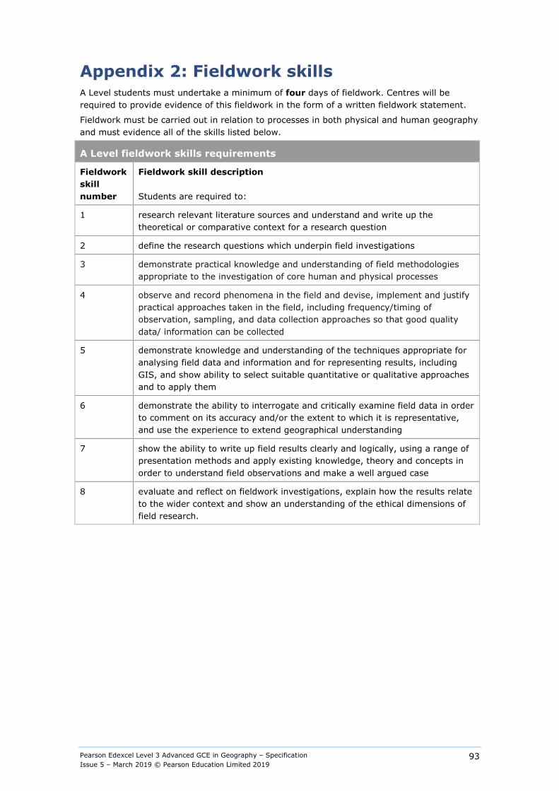
Pearson Edexcel Level 3 Advanced GCE in Geography – Specification Issue 5 – March 2019 © Pearson Education Limited 2019
93
Appendix 2: Fieldwork skills A Level students must undertake a minimum of four days of fieldwork. Centres will be required to provide evidence of this fieldwork in the form of a written fieldwork statement.
Fieldwork must be carried out in relation to processes in both physical and human geography and must evidence all of the skills listed below.
A Level fieldwork skills requirements
Fieldwork skill number
Fieldwork skill description Students are required to:
1 research relevant literature sources and understand and write up the theoretical or comparative context for a research question
2 define the research questions which underpin field investigations
3 demonstrate practical knowledge and understanding of field methodologies appropriate to the investigation of core human and physical processes
4 observe and record phenomena in the field and devise, implement and justify practical approaches taken in the field, including frequency/timing of observation, sampling, and data collection approaches so that good quality data/ information can be collected
5 demonstrate knowledge and understanding of the techniques appropriate for analysing field data and information and for representing results, including GIS, and show ability to select suitable quantitative or qualitative approaches and to apply them
6 demonstrate the ability to interrogate and critically examine field data in order to comment on its accuracy and/or the extent to which it is representative, and use the experience to extend geographical understanding
7 show the ability to write up field results clearly and logically, using a range of presentation methods and apply existing knowledge, theory and concepts in order to understand field observations and make a well argued case
8 evaluate and reflect on fieldwork investigations, explain how the results relate to the wider context and show an understanding of the ethical dimensions of field research.

Pearson Edexcel Level 3 Advanced GCE in Geography – Specification Issue 5 – March 2019 © Pearson Education Limited 2019
94
Appendix 3: Definitions Terms used in this specification and their definition.
Term Definition
Developed country Country with very high human development (VHHD)
Developing country Country with low human development (LHD), a poor country
Emerging country Country with high and medium human development (HMHD), recently emerging country
Megacity Urban area with a population of over 10 million
Human Development is measured by the Human Development Index (HDI). For further information on which countries are categorised as Low, Medium, High and Very High Human Development by HDI please go to this website: http://hdr.undp.org
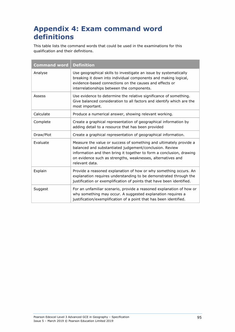
Pearson Edexcel Level 3 Advanced GCE in Geography – Specification Issue 5 – March 2019 © Pearson Education Limited 2019
95
Appendix 4: Exam command word definitions This table lists the command words that could be used in the examinations for this qualification and their definitions.
Command word Definition
Analyse Use geographical skills to investigate an issue by systematically breaking it down into individual components and making logical, evidence-based connections on the causes and effects or interrelationships between the components.
Assess Use evidence to determine the relative significance of something. Give balanced consideration to all factors and identify which are the most important.
Calculate Produce a numerical answer, showing relevant working.
Complete Create a graphical representation of geographical information by adding detail to a resource that has been provided
Draw/Plot Create a graphical representation of geographical information.
Evaluate Measure the value or success of something and ultimately provide a balanced and substantiated judgement/conclusion. Review information and then bring it together to form a conclusion, drawing on evidence such as strengths, weaknesses, alternatives and relevant data.
Explain Provide a reasoned explanation of how or why something occurs. An explanation requires understanding to be demonstrated through the justification or exemplification of points that have been identified.
Suggest For an unfamiliar scenario, provide a reasoned explanation of how or why something may occur. A suggested explanation requires a justification/exemplification of a point that has been identified.
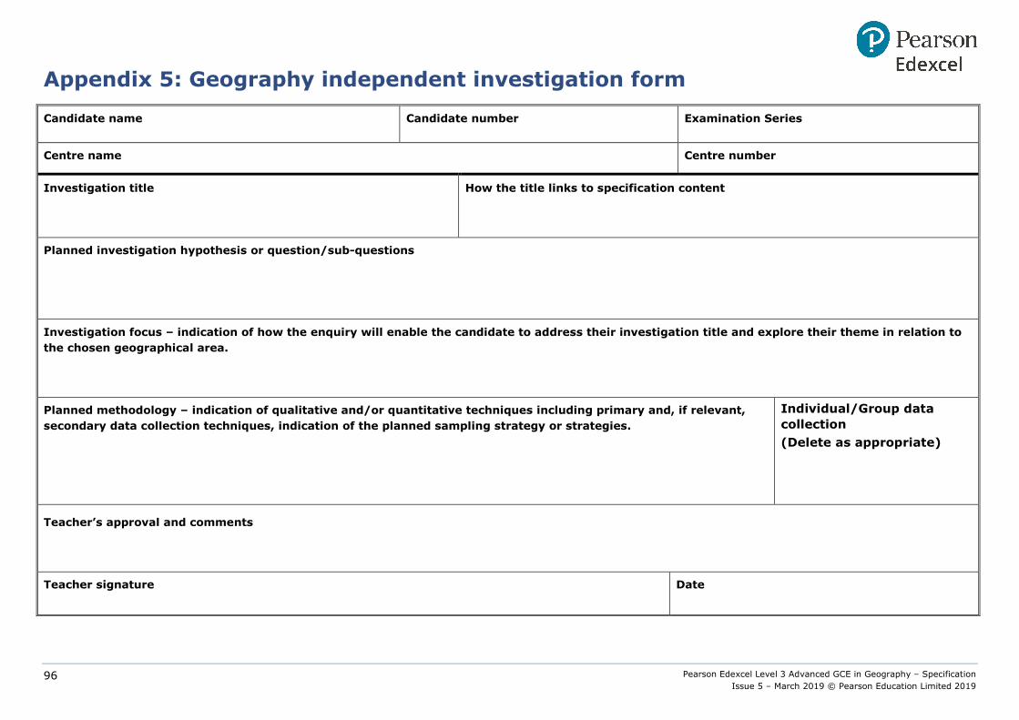
Pearson Edexcel Level 3 Advanced GCE in Geography – Specification Issue 5 – March 2019 © Pearson Education Limited 2019
96
Appendix 5: Geography independent investigation form
Candidate name Candidate number Examination Series
Centre name Centre number
Investigation title
How the title links to specification content
Planned investigation hypothesis or question/sub-questions
Investigation focus – indication of how the enquiry will enable the candidate to address their investigation title and explore their theme in relation to the chosen geographical area.
Planned methodology – indication of qualitative and/or quantitative techniques including primary and, if relevant, secondary data collection techniques, indication of the planned sampling strategy or strategies.
Individual/Group data collection (Delete as appropriate)
Teacher’s approval and comments
Teacher signature
Date

Pearson Edexcel Level 3 Advanced GCE in Geography – Specification Issue 5 – March 2019 © Pearson Education Limited 2019
97
Pearson Edexcel Level 3 Advanced GCE in Geography 9GE0/04
Centre name:
Centre number:
Candidate name:
Candidate number:
Assignment Mark awarded Comments
[NB: Comment box expands as you start entering text]
Independent Investigation
TOTAL
/70
Teacher declaration I declare that: ● any assistance which goes beyond general guidance has been recorded and
taken into account when marking the work; ● otherwise, apart from general guidance given in line with the parameters set
out in the specification, the work is solely that of the candidate concerned; ● the work was completed under the required conditions; ● signed candidate declarations will be kept on file.
Candidate declaration
I declare that, apart from collaboration with other candidates and general guidance from the teacher, where these are acceptable within the parameters of the specification, this is my own unaided work.
Assessor name: Date: Candidate signed: Date:
Assessor signed:
Additional candidate declaration
By signing this additional declaration you agree to your work being used to support Professional Development, Online Support and Training of both Centre-Assessors and Pearson Moderators. If you have any concerns please email: [email protected]
Candidate signed: Date:

Pearson Edexcel Level 3 Advanced GCE in Geography – Specification Issue 5 – March 2019 © Pearson Education Limited 2019
98
Appendix 6: Descriptions of the level of independence required at different stages of the Independent Investigation
Investigation stage What is the level of independence expected?
What does this level of independence mean in practice at this stage? (The following is not exhaustive)
1. Exploring focus Collaboration allowed Centres may want to give candidates a free choice of investigations focusing on any of the compulsory or optional content or they may wish to provide candidates with a theme or a range of themes. However, it is not acceptable for candidates to choose from a list of titles or investigations provided by the centre1.
Candidates may discuss together, and with their teacher, ideas and research for appropriate geographical questions.
2. Title of the investigation, focus of investigation (sub-questions), purpose of investigation.
Independent work Following the first stage candidates must finalise the draft title of their investigation. This must be done by each candidate on his/her own. In the Geography Independent Investigation Form and final written report candidates must provide a clear justification and contextualisation of how their enquiry will help them to address their title and explore their theme in relation to the chosen geographical location.
3. Devising methodology and sampling framework
Collaboration allowed Candidates may collaborate when planning and selecting methodologies/sampling strategies.
4. Primary data collection Collaboration allowed Primary data collection may be carried out individually or in groups.
5. Secondary data collection (if relevant) Independent work Must be carried out independently. Candidates select secondary sources of data on their own.
1 This applies also to third party fieldwork providers. Teachers must ensure that at all times they remain confident in the authenticity and independence of the candidate’s work.

Pearson Edexcel Level 3 Advanced GCE in Geography – Specification Issue 5 – March 2019 © Pearson Education Limited 2019
99
Investigation stage What is the level of independence expected?
What does this level of independence mean in practice at this stage? (The following is not exhaustive)
6. Data/information presentation Independent work Candidates select and use appropriate data presentation methods on their own.
7. Data analysis and explanation/interpretation Independent work Candidates select and use appropriate data analysis techniques and independently interpret and analyse the results on their own.
8. Conclusions and evaluation Independent work Candidates evaluate the findings of their investigation and reach a balanced and supported conclusion on their own.
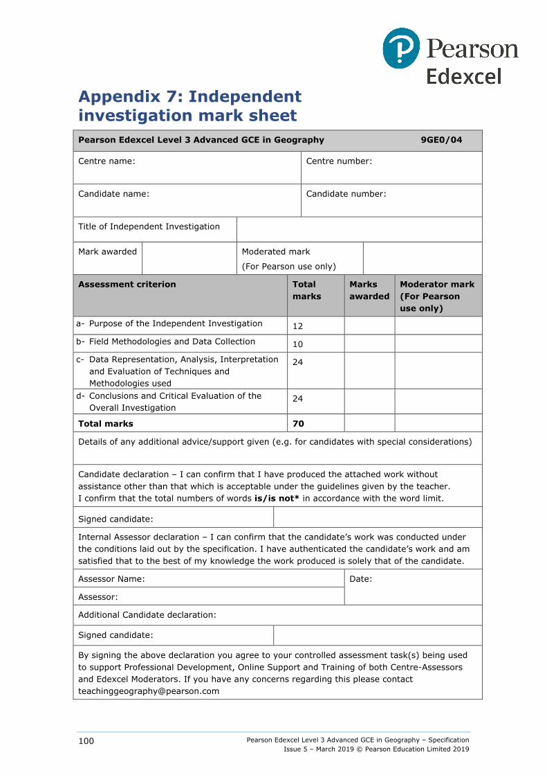
Pearson Edexcel Level 3 Advanced GCE in Geography – Specification Issue 5 – March 2019 © Pearson Education Limited 2019
100
Appendix 7: Independent investigation mark sheet Pearson Edexcel Level 3 Advanced GCE in Geography 9GE0/04
Centre name:
Centre number:
Candidate name:
Candidate number:
Title of Independent Investigation
Mark awarded Moderated mark
(For Pearson use only)
Assessment criterion Total marks
Marks awarded
Moderator mark (For Pearson use only)
a- Purpose of the Independent Investigation 12
b- Field Methodologies and Data Collection 10
c- Data Representation, Analysis, Interpretation and Evaluation of Techniques and Methodologies used
24
d- Conclusions and Critical Evaluation of the Overall Investigation
24
Total marks 70
Details of any additional advice/support given (e.g. for candidates with special considerations)
Candidate declaration – I can confirm that I have produced the attached work without assistance other than that which is acceptable under the guidelines given by the teacher. I confirm that the total numbers of words is/is not* in accordance with the word limit.
Signed candidate:
Internal Assessor declaration – I can confirm that the candidate’s work was conducted under the conditions laid out by the specification. I have authenticated the candidate’s work and am satisfied that to the best of my knowledge the work produced is solely that of the candidate.
Assessor Name: Date:
Assessor:
Additional Candidate declaration:
Signed candidate:
By signing the above declaration you agree to your controlled assessment task(s) being used to support Professional Development, Online Support and Training of both Centre-Assessors and Edexcel Moderators. If you have any concerns regarding this please contact [email protected]
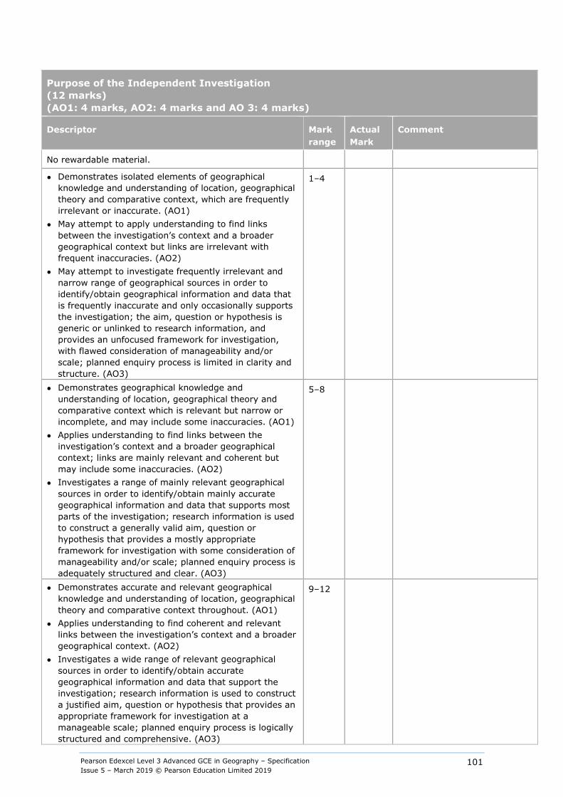
Pearson Edexcel Level 3 Advanced GCE in Geography – Specification Issue 5 – March 2019 © Pearson Education Limited 2019
101
Purpose of the Independent Investigation (12 marks) (AO1: 4 marks, AO2: 4 marks and AO 3: 4 marks)
Descriptor Mark range
Actual Mark
Comment
No rewardable material.
● Demonstrates isolated elements of geographical knowledge and understanding of location, geographical theory and comparative context, which are frequently irrelevant or inaccurate. (AO1)
● May attempt to apply understanding to find links between the investigation’s context and a broader geographical context but links are irrelevant with frequent inaccuracies. (AO2)
● May attempt to investigate frequently irrelevant and narrow range of geographical sources in order to identify/obtain geographical information and data that is frequently inaccurate and only occasionally supports the investigation; the aim, question or hypothesis is generic or unlinked to research information, and provides an unfocused framework for investigation, with flawed consideration of manageability and/or scale; planned enquiry process is limited in clarity and structure. (AO3)
1–4
● Demonstrates geographical knowledge and understanding of location, geographical theory and comparative context which is relevant but narrow or incomplete, and may include some inaccuracies. (AO1)
● Applies understanding to find links between the investigation’s context and a broader geographical context; links are mainly relevant and coherent but may include some inaccuracies. (AO2)
● Investigates a range of mainly relevant geographical sources in order to identify/obtain mainly accurate geographical information and data that supports most parts of the investigation; research information is used to construct a generally valid aim, question or hypothesis that provides a mostly appropriate framework for investigation with some consideration of manageability and/or scale; planned enquiry process is adequately structured and clear. (AO3)
5–8
● Demonstrates accurate and relevant geographical knowledge and understanding of location, geographical theory and comparative context throughout. (AO1)
● Applies understanding to find coherent and relevant links between the investigation’s context and a broader geographical context. (AO2)
● Investigates a wide range of relevant geographical sources in order to identify/obtain accurate geographical information and data that support the investigation; research information is used to construct a justified aim, question or hypothesis that provides an appropriate framework for investigation at a manageable scale; planned enquiry process is logically structured and comprehensive. (AO3)
9–12

Pearson Edexcel Level 3 Advanced GCE in Geography – Specification Issue 5 – March 2019 © Pearson Education Limited 2019
102
Field Methodologies and Data Collection (10 marks) (AO3: 10 marks)
Descriptor Mark range
Actual Mark
Comment
No rewardable material.
● An inappropriate balance between range and depth of methods chosen to collect data and information relevant to the geographical focus. (AO3)
● A sampling framework is absent or is not relevant to the topic being investigated. (AO3)
● No consideration of either frequency or timing of observations. (AO3)
● Research planning shows limited understanding of the ethical dimensions of field research methods. (AO3)
● Poor quality data and information as a result of inaccurate use of methods with low levels of accuracy/precision. (AO3)
1–3
● Chooses methods to collect data and information relevant to the geographical topic. (AO3)
● A sampling framework is considered but may not be technically valid or successfully implemented. (AO3)
● Consideration of either frequency or timing of observations. (AO3)
● Research planning shows understanding of the ethical dimensions of field research methods, which may be generic or incomplete. (AO3)
● Data and information collected using methods with inconsistent accuracy/precision. (AO3)
4–7
● Chooses appropriate methods to collect a range of data and information relevant to the geographical topic. (A03)
● Designs a valid sampling framework explicitly linked and appropriate to the geographical focus being investigated. (AO3)
● Considers both frequency and timing of observations. (AO3)
● Research planning shows appropriate and relevant understanding of the ethical dimensions of field research methods. (AO3)
● Obtains reliable data and information as a result of consistent use of methods with high levels of accuracy/precision. (AO3)
8–10
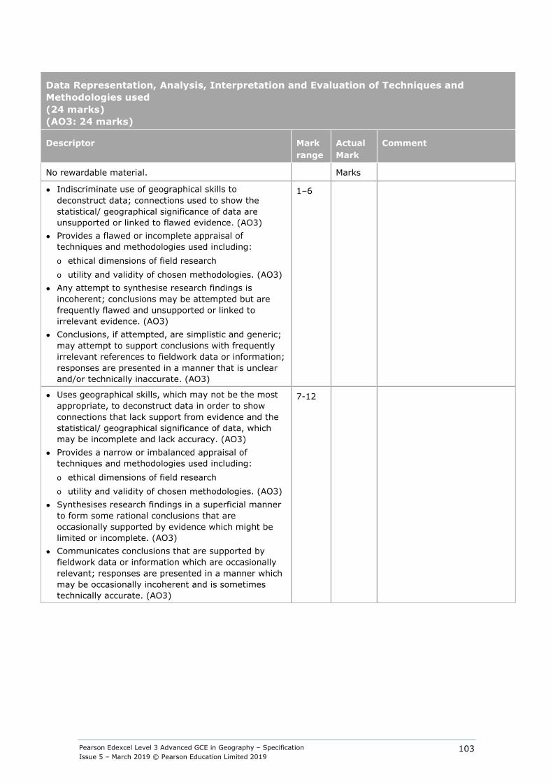
Pearson Edexcel Level 3 Advanced GCE in Geography – Specification Issue 5 – March 2019 © Pearson Education Limited 2019
103
Data Representation, Analysis, Interpretation and Evaluation of Techniques and Methodologies used (24 marks) (AO3: 24 marks)
Descriptor Mark range
Actual Mark
Comment
No rewardable material. Marks
● Indiscriminate use of geographical skills to deconstruct data; connections used to show the statistical/ geographical significance of data are unsupported or linked to flawed evidence. (AO3)
● Provides a flawed or incomplete appraisal of techniques and methodologies used including: o ethical dimensions of field research o utility and validity of chosen methodologies. (AO3)
● Any attempt to synthesise research findings is incoherent; conclusions may be attempted but are frequently flawed and unsupported or linked to irrelevant evidence. (AO3)
● Conclusions, if attempted, are simplistic and generic; may attempt to support conclusions with frequently irrelevant references to fieldwork data or information; responses are presented in a manner that is unclear and/or technically inaccurate. (AO3)
1–6
● Uses geographical skills, which may not be the most appropriate, to deconstruct data in order to show connections that lack support from evidence and the statistical/ geographical significance of data, which may be incomplete and lack accuracy. (AO3)
● Provides a narrow or imbalanced appraisal of techniques and methodologies used including: o ethical dimensions of field research o utility and validity of chosen methodologies. (AO3)
● Synthesises research findings in a superficial manner to form some rational conclusions that are occasionally supported by evidence which might be limited or incomplete. (AO3)
● Communicates conclusions that are supported by fieldwork data or information which are occasionally relevant; responses are presented in a manner which may be occasionally incoherent and is sometimes technically accurate. (AO3)
7-12
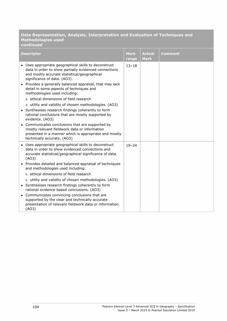
Pearson Edexcel Level 3 Advanced GCE in Geography – Specification Issue 5 – March 2019 © Pearson Education Limited 2019
104
Data Representation, Analysis, Interpretation and Evaluation of Techniques and Methodologies used continued
Descriptor Mark range
Actual Mark
Comment
● Uses appropriate geographical skills to deconstruct data in order to show partially evidenced connections and mostly accurate statistical/geographical significance of data. (AO3)
● Provides a generally balanced appraisal, that may lack detail in some aspects of techniques and methodologies used including: o ethical dimensions of field research o utility and validity of chosen methodologies. (AO3)
● Synthesises research findings coherently to form rational conclusions that are mostly supported by evidence. (AO3)
● Communicates conclusions that are supported by mostly relevant fieldwork data or information presented in a manner which is appropriate and mostly technically accurate. (AO3)
13–18
● Uses appropriate geographical skills to deconstruct data in order to show evidenced connections and accurate statistical/geographical significance of data. (AO3)
● Provides detailed and balanced appraisal of techniques and methodologies used including: o ethical dimensions of field research o utility and validity of chosen methodologies. (AO3)
● Synthesises research findings coherently to form rational evidence-based conclusions. (AO3)
● Communicates convincing conclusions that are supported by the clear and technically accurate presentation of relevant fieldwork data or information. (AO3)
19–24
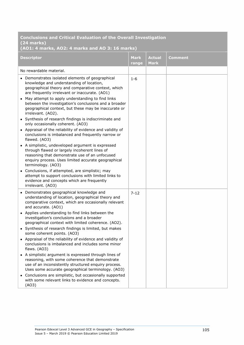
Pearson Edexcel Level 3 Advanced GCE in Geography – Specification Issue 5 – March 2019 © Pearson Education Limited 2019
105
Conclusions and Critical Evaluation of the Overall Investigation (24 marks) (AO1: 4 marks, AO2: 4 marks and AO 3: 16 marks)
Descriptor Mark range
Actual Mark
Comment
No rewardable material.
● Demonstrates isolated elements of geographical knowledge and understanding of location, geographical theory and comparative context, which are frequently irrelevant or inaccurate. (AO1)
● May attempt to apply understanding to find links between the investigation’s conclusions and a broader geographical context, but these may be inaccurate or irrelevant. (AO2).
● Synthesis of research findings is indiscriminate and only occasionally coherent. (AO3)
● Appraisal of the reliability of evidence and validity of conclusions is imbalanced and frequently narrow or flawed. (AO3)
● A simplistic, undeveloped argument is expressed through flawed or largely incoherent lines of reasoning that demonstrate use of an unfocused enquiry process. Uses limited accurate geographical terminology. (AO3)
● Conclusions, if attempted, are simplistic; may attempt to support conclusions with limited links to evidence and concepts which are frequently irrelevant. (AO3)
1-6
● Demonstrates geographical knowledge and understanding of location, geographical theory and comparative context, which are occasionally relevant and accurate. (AO1)
● Applies understanding to find links between the investigation’s conclusions and a broader geographical context with limited coherence. (AO2).
● Synthesis of research findings is limited, but makes some coherent points. (AO3)
● Appraisal of the reliability of evidence and validity of conclusions is imbalanced and includes some minor flaws. (AO3)
● A simplistic argument is expressed through lines of reasoning, with some coherence that demonstrate use of an inconsistently structured enquiry process. Uses some accurate geographical terminology. (AO3)
● Conclusions are simplistic, but occasionally supported with some relevant links to evidence and concepts. (AO3)
7-12

Pearson Edexcel Level 3 Advanced GCE in Geography – Specification Issue 5 – March 2019 © Pearson Education Limited 2019
106
Descriptor Mark range
Actual Mark
Comment
● Demonstrates mostly accurate and relevant geographical knowledge and understanding of location, geographical theory and comparative context. (AO1)
● Applies understanding to find largely coherent and relevant links between the investigation’s conclusions and a broader geographical context. (AO2)
● Synthesises most aspects of the research findings in a largely coherent manner. (AO3)
● Provides a mainly appropriate appraisal of the reliability of evidence and validity of conclusions. (AO3)
● A developed argument which considers a relevant selection of factors in an uneven manner and which is expressed through logical lines of reasoning that are clear, but not fully developed and demonstrates a use of an appropriately structured enquiry process. Uses mostly accurate geographical terminology.(AO3)
● Conclusions are mostly supported by drawing together a selection of mostly relevant evidence and concepts linked to the investigation. (AO3)
13-18
● Demonstrates accurate and relevant geographical knowledge and understanding of location, geographical theory and comparative context throughout. (AO1)
● Applies understanding to find coherent and relevant links between the investigation’s conclusions and a broader geographical context. (AO2)
● Synthesises research findings coherently and comprehensively. (AO3)
● Provides a balanced appraisal of the reliability of evidence and validity of conclusions. (AO3)
● A balanced and concise, well-developed argument is expressed through sustained logical lines of reasoning that demonstrates use of a structured and comprehensive enquiry process. Uses accurate geographical terminology throughout. (AO3)
● Convincing conclusions that are fully supported by drawing together a selection of relevant evidence and concepts linked to the entire purpose of the investigation. (AO3)
19-24

Pearson Edexcel Level 3 Advanced GCE in Geography – Specification Issue 5 – March 2019 © Pearson Education Limited 2019
107
Appendix 8: Fieldwork statement Pearson Edexcel Level 3 Advanced GCE in Geography 9GE0/04
Centre name:
Centre number:
All students must carry out four days of fieldwork outside of the classroom and school grounds.
Details of fieldwork
Fieldwork day 1
Fieldwork date: _______________________
Location: ____________________________
Number of students: ___________________
Summary of geographical issues/questions investigated:
Fieldwork day 2
Fieldwork date: _______________________
Location: ____________________________
Number of students: ___________________
Summary of geographical issues/questions investigated:
Fieldwork day 3
Fieldwork date: ______________________
Location: ___________________________
Number of students: __________________
Summary of geographical issues/questions investigated:
Fieldwork day 4
Fieldwork date: _______________________
Location: ____________________________
Number of students: ___________________
Summary of geographical issues/questions investigated
Head teacher declaration
I declare that the fieldwork days recorded above have been carried out in accordance with the geography fieldwork requirements.
Head teacher name:
Head teacher signature: Date:
Pearson Edexcel Level 3 Advanced GCE in Geography – Specification Issue 5 – March 2019 © Pearson Education Limited 2019
108
Appendix 9: The context for the development of this qualification All our qualifications are designed to meet our World Class Qualification Principles[1] and our ambition to put the student at the heart of everything we do.
We have developed and designed this qualification by: ● reviewing other curricula and qualifications to ensure that it is comparable with those
taken in high-performing jurisdictions overseas ● consulting with key stakeholders on content and assessment, including learned bodies,
subject associations, higher-education academics, teachers and employers to ensure this qualification is suitable for a UK context
● reviewing the legacy qualification and building on its positive attributes.
This qualification has also been developed to meet criteria stipulated by Ofqual in their documents GCE Qualification Level Conditions and Requirements and GCE Subject Level Conditions and Requirements for Geography, published in March 2015.
[1] Pearson’s World Class Qualification Principles ensure that our qualifications are: ● demanding, through internationally benchmarked standards, encouraging deep learning and
measuring higher-order skills ● rigorous, through setting and maintaining standards over time, developing reliable and valid
assessment tasks and processes, and generating confidence in end users of the knowledge, skills and competencies of certified students
● inclusive, through conceptualising learning as continuous, recognising that students develop at different rates and have different learning needs, and focusing on progression
● empowering, through promoting the development of transferable skills, see Appendix 10: Transferable Skills.

Pearson Edexcel Level 3 Advanced GCE in Geography – Specification Issue 5 – March 2019 © Pearson Education Limited 2019
109
From Pearson’s Expert Panel for World Class Qualifications May 2014
“The reform of the qualifications system in England is a profoundly important change to the education system. Teachers need to know that the new qualifications will assist them in helping their learners make progress in their lives.
When these changes were first proposed we were approached by Pearson to join an ‘Expert Panel’ that would advise them on the development of the new qualifications.
We were chosen, either because of our expertise in the UK education system, or because of our experience in reforming qualifications in other systems around the world as diverse as Singapore, Hong Kong, Australia and a number of countries across Europe.
We have guided Pearson through what we judge to be a rigorous qualification development process that has included: ● Extensive international comparability of subject content against the highest-performing
jurisdictions in the world ● Benchmarking assessments against UK and overseas providers to ensure that they are at
the right level of demand ● Establishing External Subject Advisory Groups, drawing on independent subject-specific
expertise to challenge and validate our qualifications ● Subjecting the final qualifications to scrutiny against the DfE content and Ofqual
accreditation criteria in advance of submission.
Importantly, we have worked to ensure that the content and learning is future oriented. The design has been guided by what is called an ‘Efficacy Framework’, meaning learner outcomes have been at the heart of this development throughout.
We understand that ultimately it is excellent teaching that is the key factor to a learner’s success in education. As a result of our work as a panel we are confident that we have supported the development of qualifications that are outstanding for their coherence, thoroughness and attention to detail and can be regarded as representing world-class best practice.”
Sir Michael Barber (Chair)
Chief Education Advisor, Pearson plc
Professor Lee Sing Kong
Director, National Institute of Education, Singapore
Bahram Bekhradnia
President, Higher Education Policy Institute
Professor Jonathan Osborne
Stanford University
Dame Sally Coates
Principal, Burlington Danes Academy
Professor Dr Ursula Renold
Federal Institute of Technology, Switzerland
Professor Robin Coningham
Pro-Vice Chancellor, University of Durham
Professor Bob Schwartz
Harvard Graduate School of Education
Dr Peter Hill
Former Chief Executive ACARA
All titles correct as at May 2014
Pearson Edexcel Level 3 Advanced GCE in Geography – Specification Issue 5 – March 2019 © Pearson Education Limited 2019
110
Appendix 10: Transferable skills The need for transferable skills In recent years, higher education institutions and employers have consistently flagged the need for students to develop a range of transferable skills to enable them to respond with confidence to the demands of undergraduate study and the world of work.
The Organisation for Economic Co-operation and Development (OECD) defines skills, or competencies, as ‘the bundle of knowledge, attributes and capacities that can be learned and that enable individuals to successfully and consistently perform an activity or task and can be built upon and extended through learning.’ [1]
To support the design of our qualifications, the Pearson Research Team selected and evaluated seven global 21st-century skills frameworks. Following on from this process, we identified the National Research Council’s (NRC) framework as the most evidence-based and robust skills framework. We adapted the framework slightly to include the Program for International Student Assessment (PISA) ICT Literacy and Collaborative Problem Solving (CPS) Skills.
The adapted National Research Council’s framework of skills involves: [2]
Cognitive skills ● Non-routine problem solving – expert thinking, metacognition, creativity. ● Systems thinking – decision making and reasoning. ● Critical thinking – definitions of critical thinking are broad and usually involve general
cognitive skills such as analysing, synthesising and reasoning skills. ● ICT literacy – access, manage, integrate, evaluate, construct and communicate.[3]
Interpersonal skills ● Communication – active listening, oral communication, written communication, assertive
communication and non-verbal communication. ● Relationship-building skills – teamwork, trust, intercultural sensitivity, service
orientation, self-presentation, social influence, conflict resolution and negotiation. ● Collaborative problem solving – establishing and maintaining shared understanding,
taking appropriate action, establishing and maintaining team organisation.
Intrapersonal skills ● Adaptability – ability and willingness to cope with the uncertain, handling work stress,
adapting to different personalities, communication styles and cultures, and physical adaptability to various indoor and outdoor work environments.
● Self-management and self-development – ability to work remotely in virtual teams, work autonomously, be self-motivating and self-monitoring, willing and able to acquire new information and skills related to work.
Transferable skills enable young people to face the demands of further and higher education, as well as the demands of the workplace, and are important in the teaching and learning of this qualification. We will provide teaching and learning materials, developed with stakeholders, to support our qualifications.
[1] OECD – Better Skills, Better Jobs, Better Lives (OECD Publishing, 2012) [2] Koenig J A, National Research Council – Assessing 21st Century Skills: Summary of a Workshop (National
Academies Press, 2011) [3] PISA – The PISA Framework for Assessment of ICT Literacy (2011)
Pearson Edexcel Level 3 Advanced GCE in Geography – Specification Issue 5 – March 2019 © Pearson Education Limited 2019
111
Appendix 11: Level 3 Extended Project qualification What is the Extended Project? The Extended Project is a standalone qualification that can be taken alongside GCEs. It supports the development of independent learning skills and helps to prepare students for their next step – whether that be higher education study or employment. The qualification:
● is recognised by higher education for the skills it develops ● is worth half of an Advanced GCE qualification at grades A*–E ● carries UCAS points for university entry.
The Extended Project encourages students to develop skills in the following areas: research, critical thinking, extended writing and project management. Students identify and agree a topic area of their choice for in-depth study (which may or may not be related to a GCE subject they are already studying), guided by their teacher.
Students can choose from one of four approaches to produce: ● a dissertation (for example an investigation based on predominately secondary research) ● an investigation/field study (for example a practical experiment) ● a performance (for example in music, drama or sport) ● an artefact (for example creating a sculpture in response to a client brief or solving an
engineering problem).
The qualification is non-examination assessment based and students are assessed on the skills of managing, planning and evaluating their project. Students will research their topic, develop skills to review and evaluate the information, and then present the final outcome of their project.
The Extended Project has 120 guided learning hours (GLH) consisting of a 40-GLH taught element that includes teaching the technical skills (for example research skills) and an 80-GLH guided element that includes mentoring students through the project work. The qualification is 100% internally assessed and externally moderated.
How to link the Extended Project with geography The Extended Project creates the opportunity to develop transferable skills for progression to higher education and to the workplace, through the exploration of either an area of personal interest or a topic of interest from within the geography qualification content.
Through the Extended Project, students will develop skills that support their study of geography, including: ● conducting, organising and using research ● independent reading in the subject area ● planning, project management and time management ● defining a hypothesis to be tested in investigations ● collecting, handling and interpreting data and evidence ● evaluating arguments and processes, including arguments in favour of alternative
interpretations of data and evaluation of experimental methodology ● critical thinking.
In the context of the Extended Project, critical thinking refers to the ability to identify and develop arguments for a point of view or hypothesis and to consider and respond to alternative arguments and interpretations of information. This supports the development of evaluative skills, through evaluating geographical data, and using qualitative and quantitative evidence to support informed judgements and propose evidence-based solutions to geographical issues.
Pearson Edexcel Level 3 Advanced GCE in Geography – Specification Issue 5 – March 2019 © Pearson Education Limited 2019
112
Types of Extended Project related to geography Students may produce a dissertation on any topic that can be researched and argued, for example a controversial geographical issue such as landscape management or public opinion on re-branding or re-imaging of an urban or rural area.
A dissertation might involve an investigation such as: ● the impact of changes to the built environment in a chosen urban or rural area ● an investigation into the success of coastal management approaches in a chosen area.
The dissertation uses secondary research sources to provide a reasoned defence or a point of view, with consideration of alternative interpretations of data and evidence.
An alternative might be an investigative project or field study involving the collection of data from primary research, for example: ● a study of the impact of human activity on a glaciated area ● a survey of historical change in an area.
A field study might consider an issue that lends itself to primary research, for example an investigation into local perceptions of the impact of a regeneration project in a rural or urban area.
Using the Extended Project to support breadth and depth In the Extended Project, students are assessed on the quality of the work they produce and the skills they develop and demonstrate through completing this work. Students should demonstrate that they have extended themselves in some significant way beyond what they have been studying in geography. Students can demonstrate extension in one or more dimensions: ● deepening understanding – where a student explores a topic in greater depth than in
the specification content. This could be an in-depth exploration of one aspect of one of the synoptic themes specified in the specification
● broadening skills – where a student learns a new skill. This might be learning a new statistical technique that can be used in the analysis of either primary or secondary data collected by the student
● widening perspectives – where the student’s project spans different subjects. A student studying geography with business may wish to research the impact of tourism on a particular region or locality.
A wide range of information to support the delivery and assessment of the Extended Project, including the specification, teacher guidance for all aspects, an editable scheme of work and exemplars for all four approaches, can be found on our website.
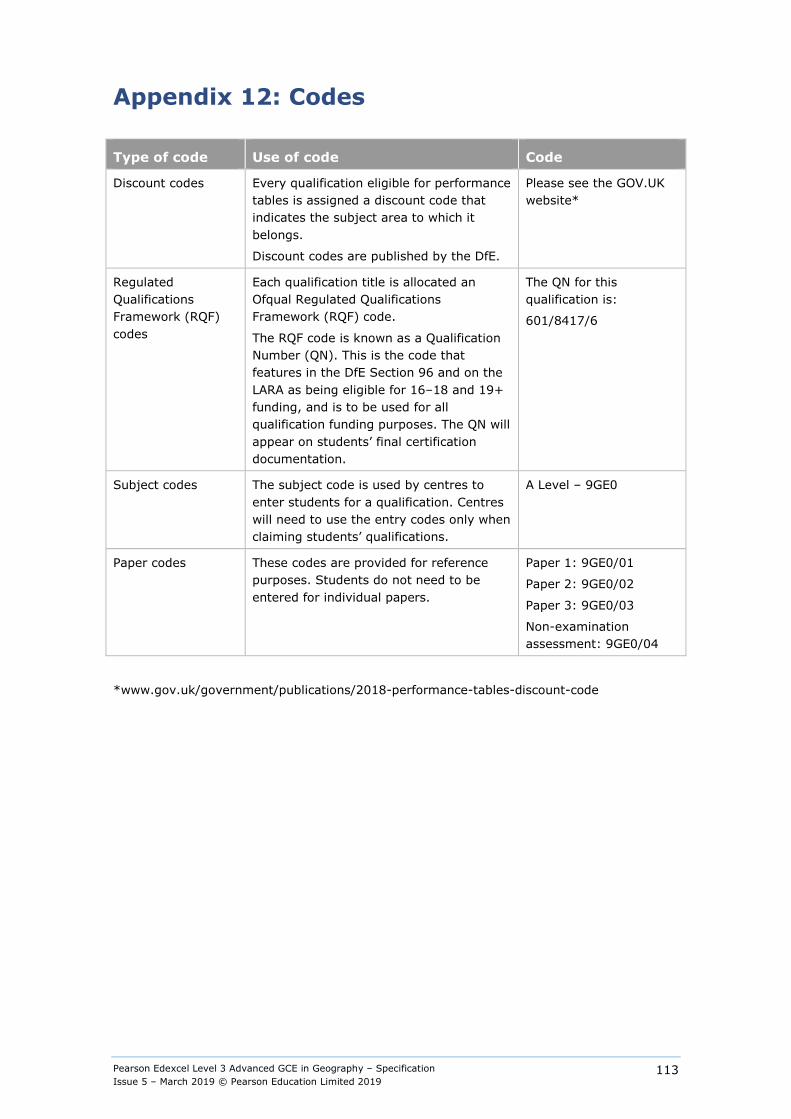
Pearson Edexcel Level 3 Advanced GCE in Geography – Specification Issue 5 – March 2019 © Pearson Education Limited 2019
113
Appendix 12: Codes
Type of code Use of code Code
Discount codes Every qualification eligible for performance tables is assigned a discount code that indicates the subject area to which it belongs.
Discount codes are published by the DfE.
Please see the GOV.UK website*
Regulated Qualifications Framework (RQF) codes
Each qualification title is allocated an Ofqual Regulated Qualifications Framework (RQF) code.
The RQF code is known as a Qualification Number (QN). This is the code that features in the DfE Section 96 and on the LARA as being eligible for 16–18 and 19+ funding, and is to be used for all qualification funding purposes. The QN will appear on students’ final certification documentation.
The QN for this qualification is:
601/8417/6
Subject codes The subject code is used by centres to enter students for a qualification. Centres will need to use the entry codes only when claiming students’ qualifications.
A Level – 9GE0
Paper codes These codes are provided for reference purposes. Students do not need to be entered for individual papers.
Paper 1: 9GE0/01
Paper 2: 9GE0/02
Paper 3: 9GE0/03
Non-examination assessment: 9GE0/04
*www.gov.uk/government/publications/2018-performance-tables-discount-code
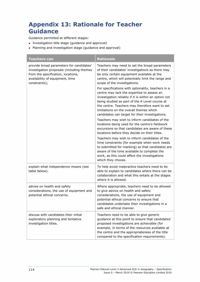
Pearson Edexcel Level 3 Advanced GCE in Geography – Specification Issue 5 – March 2019 © Pearson Education Limited 2019
114
Appendix 13: Rationale for Teacher Guidance Guidance permitted at different stages: ● Investigation title stage (guidance and approval) ● Planning and investigation stage (guidance and approval)
Teachers can Rationale
provide broad parameters for candidates’ investigation proposals (including themes from the specification, locations, availability of equipment, time constraints);
Teachers may need to set the broad parameters of their candidates’ investigations as there may be only certain equipment available at the centre, which will potentially limit the range and scope of the investigations.
For specifications with optionality, teachers in a centre may lack the expertise to assess an investigation reliably if it is within an option not being studied as part of the A Level course at the centre. Teachers may therefore want to set limitations on the overall themes which candidates can target for their investigations.
Teachers may wish to inform candidates of the locations being used for the centre’s fieldwork excursions so that candidates are aware of these locations before they decide on their titles.
Teachers may wish to inform candidates of the time constraints (for example when work needs to submitted for marking) so that candidates are aware of the time available to complete the work, as this could affect the investigations which they choose.
explain what independence means (see table below).
To help avoid malpractice teachers need to be able to explain to candidates where there can be collaboration and what this entails at the stages where it is allowed.
advise on health and safety considerations, the use of equipment and potential ethical concerns.
Where appropriate, teachers need to be allowed to give advice on health and safety considerations, the use of equipment and potential ethical concerns to ensure that candidates undertake their investigations in a safe and ethical manner.
discuss with candidates their initial exploratory planning and tentative investigation titles.
Teachers need to be able to give generic guidance at this point to ensure that candidates’ proposed investigations are achievable (for example, in terms of the resources available at the centre and the appropriateness of the title compared to the specification requirements).
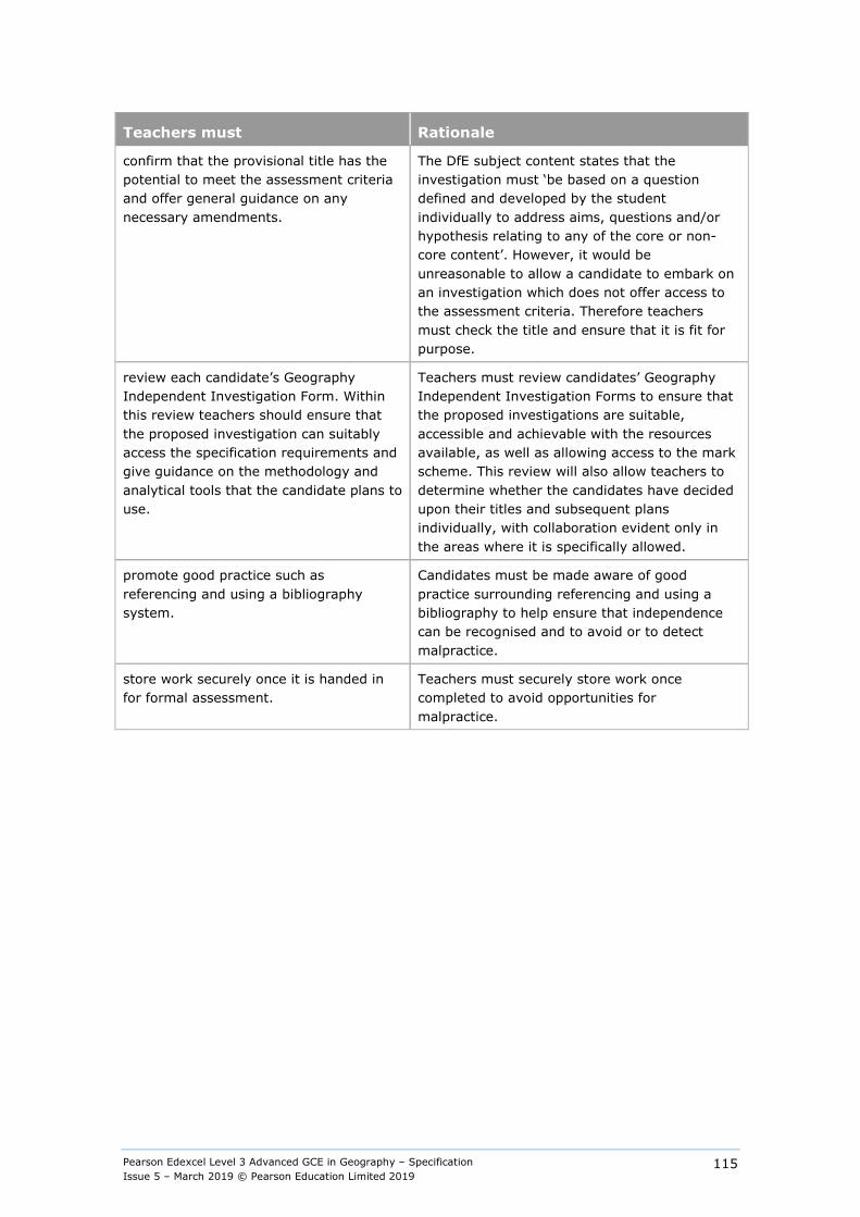
Pearson Edexcel Level 3 Advanced GCE in Geography – Specification Issue 5 – March 2019 © Pearson Education Limited 2019
115
Teachers must Rationale
confirm that the provisional title has the potential to meet the assessment criteria and offer general guidance on any necessary amendments.
The DfE subject content states that the investigation must ‘be based on a question defined and developed by the student individually to address aims, questions and/or hypothesis relating to any of the core or non-core content’. However, it would be unreasonable to allow a candidate to embark on an investigation which does not offer access to the assessment criteria. Therefore teachers must check the title and ensure that it is fit for purpose.
review each candidate’s Geography Independent Investigation Form. Within this review teachers should ensure that the proposed investigation can suitably access the specification requirements and give guidance on the methodology and analytical tools that the candidate plans to use.
Teachers must review candidates’ Geography Independent Investigation Forms to ensure that the proposed investigations are suitable, accessible and achievable with the resources available, as well as allowing access to the mark scheme. This review will also allow teachers to determine whether the candidates have decided upon their titles and subsequent plans individually, with collaboration evident only in the areas where it is specifically allowed.
promote good practice such as referencing and using a bibliography system.
Candidates must be made aware of good practice surrounding referencing and using a bibliography to help ensure that independence can be recognised and to avoid or to detect malpractice.
store work securely once it is handed in for formal assessment.
Teachers must securely store work once completed to avoid opportunities for malpractice.
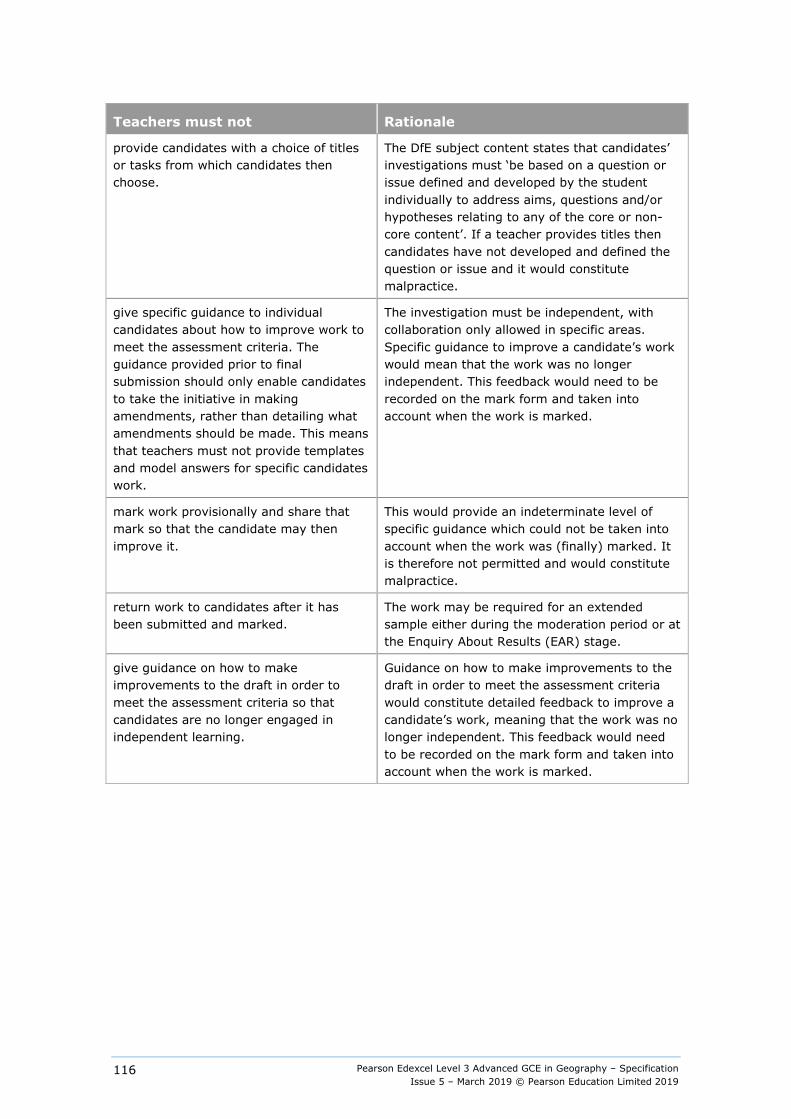
Pearson Edexcel Level 3 Advanced GCE in Geography – Specification Issue 5 – March 2019 © Pearson Education Limited 2019
116
Teachers must not Rationale
provide candidates with a choice of titles or tasks from which candidates then choose.
The DfE subject content states that candidates’ investigations must ‘be based on a question or issue defined and developed by the student individually to address aims, questions and/or hypotheses relating to any of the core or non-core content’. If a teacher provides titles then candidates have not developed and defined the question or issue and it would constitute malpractice.
give specific guidance to individual candidates about how to improve work to meet the assessment criteria. The guidance provided prior to final submission should only enable candidates to take the initiative in making amendments, rather than detailing what amendments should be made. This means that teachers must not provide templates and model answers for specific candidates work.
The investigation must be independent, with collaboration only allowed in specific areas. Specific guidance to improve a candidate’s work would mean that the work was no longer independent. This feedback would need to be recorded on the mark form and taken into account when the work is marked.
mark work provisionally and share that mark so that the candidate may then improve it.
This would provide an indeterminate level of specific guidance which could not be taken into account when the work was (finally) marked. It is therefore not permitted and would constitute malpractice.
return work to candidates after it has been submitted and marked.
The work may be required for an extended sample either during the moderation period or at the Enquiry About Results (EAR) stage.
give guidance on how to make improvements to the draft in order to meet the assessment criteria so that candidates are no longer engaged in independent learning.
Guidance on how to make improvements to the draft in order to meet the assessment criteria would constitute detailed feedback to improve a candidate’s work, meaning that the work was no longer independent. This feedback would need to be recorded on the mark form and taken into account when the work is marked.
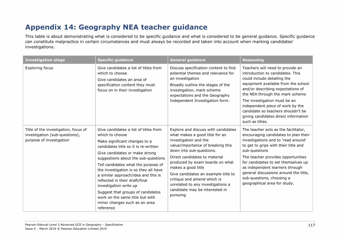
Pearson Edexcel Level 3 Advanced GCE in Geography – Specification Issue 5 – March 2019 © Pearson Education Limited 2019
117
Appendix 14: Geography NEA teacher guidance This table is about demonstrating what is considered to be specific guidance and what is considered to be general guidance. Specific guidance can constitute malpractice in certain circumstances and must always be recorded and taken into account when marking candidates’ investigations.
Investigation stage Specific guidance General guidance Reasoning
Exploring focus Give candidates a list of titles from which to choose
Give candidates an area of specification content they must focus on in their investigation
Discuss specification content to find potential themes and relevance for an investigation
Broadly outline the stages of the investigation, mark scheme expectations and the Geography Independent Investigation form.
Teachers will need to provide an introduction to candidates. This could include detailing the equipment available from the school and/or describing expectations of the NEA through the mark scheme
The investigation must be an independent piece of work by the candidate so teachers shouldn’t be giving candidates direct information such as titles.
Title of the investigation, focus of investigation (sub-questions), purpose of investigation
Give candidates a list of titles from which to choose
Make significant changes to a candidates title so it is re-written
Give candidates or make strong suggestions about the sub-questions
Tell candidates what the purpose of the investigation is so they all have a similar approach/idea and this is reflected in their draft/final investigation write up
Suggest that groups of candidates work on the same title but with minor changes such as an area reference
Explore and discuss with candidates what makes a good title for an investigation and the value/importance of breaking this down into sub-questions.
Direct candidates to material produced by exam boards on what makes a good title
Give candidates an example title to critique and amend which is unrelated to any investigations a candidate may be interested in pursuing
The teacher acts as the facilitator, encouraging candidates to plan their investigations and to ‘read around’ to get to grips with their title and sub-questions
The teacher provides opportunities for candidates to set themselves up as independent learners through general discussions around the title, sub-questions, choosing a geographical area for study.
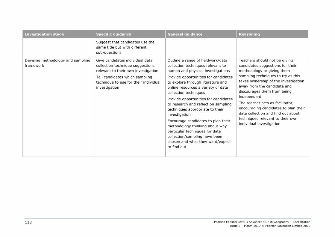
Pearson Edexcel Level 3 Advanced GCE in Geography – Specification Issue 5 – March 2019 © Pearson Education Limited 2019
118
Investigation stage Specific guidance General guidance Reasoning
Suggest that candidates use the same title but with different sub-questions
Devising methodology and sampling framework
Give candidates individual data collection technique suggestions relevant to their own investigation
Tell candidates which sampling technique to use for their individual investigation
Outline a range of fieldwork/data collection techniques relevant to human and physical investigations
Provide opportunities for candidates to explore through literature and online resources a variety of data collection techniques
Provide opportunities for candidates to research and reflect on sampling techniques appropriate to their investigation
Encourage candidates to plan their methodology thinking about why particular techniques for data collection/sampling have been chosen and what they want/expect to find out
Teachers should not be giving candidates suggestions for their methodology or giving them sampling techniques to try as this takes ownership of the investigation away from the candidate and discourages them from being independent
The teacher acts as facilitator, encouraging candidates to plan their data collection and find out about techniques relevant to their own individual investigation

Pearson Edexcel Level 3 Advanced GCE in Geography – Specification Issue 5 – March 2019 © Pearson Education Limited 2019
119
Investigation stage Specific guidance General guidance Reasoning
Primary data collection Teach and guide candidates through each data collection technique relevant to their individual investigation
Take a whole class/es on a fieldtrip and teach them all the same primary data collection techniques specific to an investigation or narrow range of investigations (such as coasts fieldwork where candidates may be taught the same data collection techniques for longshore drift, beach profiles and sediment sampling whereby ownership is taken away from candidates as they all have access to the same information and data sets)
Produce fieldwork information on primary data collection techniques specific to individual candidate titles (such as coasts working through a narrow range of primary data collection techniques specific to individual titles, as outlined in the preceding bullet point)
Outline and discuss with candidates what makes ‘good’/valuable primary data
Provide opportunities for candidates to explore a range of data collection techniques, suggesting candidates use several techniques in their investigation, in order to ascertain what works well/ doesn’t as part of their evaluation
Suggest candidates work in small groups with similar topic areas to collect primary data as a larger sample of data can potentially be collected.
The teacher acts as the facilitator, encouraging candidates to plan their data collection and find out about techniques relevant to their own individual investigation
Teachers as facilitators encourage candidates to ‘read around’ and discuss data collection techniques so that candidates can independently justify their choices of primary data collection and evaluate the success of those choices
Teachers can suggest candidates work collaboratively in small groups with similar topic areas to collect primary data. This does not however prevent candidates from collecting additional data pertinent to their individual investigations.
Sb210119Z:\LT\PD\GCE_2016\9781446950395_GCE2016_AL_GEOG_ISSUE5\9781446950395_GCE2016_AL_GEOG_ISSUE5.DOC.1–126/0

Edexcel, BTEC and LCCI qualifications
Edexcel, BTEC and LCCI qualifications are awarded by Pearson, the UK’s largest awarding body offering academic and vocational qualifications that are globally recognised and benchmarked. For further information, please visit our qualification website at qualifications.pearson.com. Alternatively, you can get in touch with us using the details on our contact us page at qualifications.pearson.com/contactus
About Pearson
Pearson is the world's leading learning company, with 35,000 employees in more than 70 countries working to help people of all ages to make measurable progress in their lives through learning. We put the learner at the centre of everything we do, because wherever learning flourishes, so do people. Find out more about how we can help you and your learners at qualifications.pearson.com
References to third party material made in this specification are made in good faith. Pearson does not endorse, approve or accept responsibility for the content of materials, which may be subject to change, or any opinions expressed therein. (Material may include textbooks, journals, magazines and other publications and websites.)
All information in this specification is correct at time of publication.
Original origami artwork: Mark Bolitho Origami photography: Pearson Education Ltd/Naki Kouyioumtzis
ISBN 978 1 446 95039 5
All the material in this publication is copyright © Pearson Education Limited 2019

For information about Pearson Qualifications, including Pearson Edexcel, BTEC and LCCI qualifications visit qualifications.pearson.com
Edexcel and BTEC are registered trademarks of Pearson Education Limited
Pearson Education Limited. Registered in England and Wales No. 872828 Registered Office: 80 Strand, London WC2R 0RL
VAT Reg No GB 278 537121
Recommended