Embed Size (px)
Citation preview
© Chevron Australia Pty Ltd
2 21 Nov 14 Issued for Use EWKL EFLH AXPA
1 28 Oct 14 Issued for Use EWKL EFLH AXPA
0 9 Oct 2014 Issued for Use EWKL EFLH AXPA
REV DATE DESCRIPTION ORIG CHK APPR
IP Security Company Confidential Total number of Pages (including Cover sheet): 30
For Contractor Documents
Contract No Contractor Document No Contractor Rev.
Company Document Control No.
Project Area Discipline Type Originator Package Sequence-
Sht Revision
WS2 1000 HES PLN CVX 000 00015-000 2
Wheatstone Project Summary Environment Plan – Topsides Installation and Hookup and Commissioning
Wheatstone Project Document No: WS2-1000-HES-PLN-CVX-000-00015-000 Summary Environment Plan – Topsides Installation and Hookup and Commissioning
Revision: 2 Revision Date: 21/11/2014
© Chevron Australia Pty Ltd Public Page 2
Uncontrolled when printed
Page left blank intentionally
Wheatstone Project Document No: WS2-1000-HES-PLN-CVX-000-00015-000 Summary Environment Plan – Topsides Installation and Hookup and Commissioning
Revision: 2 Revision Date: 21/11/2014
© Chevron Australia Pty Ltd Public Page 3
Uncontrolled when printed
TABLE OF CONTENTS
1.0 INTRODUCTION ............................................................................................................ 5
1.1 Location ................................................................................................................. 5 1.2 Nominated Titleholder Details ............................................................................... 5
2.0 ACTIVITY DESCRIPTION .............................................................................................. 7
2.1 Timeframes ........................................................................................................... 7 2.2 Topsides Installation .............................................................................................. 7 2.3 Hookup of Topsides .............................................................................................. 7 2.4 Commissioning of Topsides .................................................................................. 8 2.5 Commissioning and Operations of the Living Quarters ......................................... 8 2.6 Operation of the Accommodation Support Vessel ................................................. 8 2.7 Supporting Activities .............................................................................................. 8
2.7.1 Support Vessels ...................................................................................... 8 2.7.2 Vessel Bunkering and Transfers ............................................................. 9 2.7.3 ROV Debris Survey ................................................................................. 9 2.7.4 Helicopter Operations .............................................................................. 9
2.8 Standby Period ...................................................................................................... 9
3.0 DESCRIPTION OF THE ENVIRONMENT ................................................................... 10
3.1 Physical Environment .......................................................................................... 10 3.2 Ecological Environment ....................................................................................... 10 3.3 Socio-Economic Environment ............................................................................. 15
4.0 ENVIRONMENTAL IMPACTS AND RISKS ................................................................ 16
5.0 MANAGEMENT APPROACH ...................................................................................... 23
5.1 Roles and Responsibilities .................................................................................. 23 5.2 Training and Competency ................................................................................... 23 5.3 Monitoring and Reporting .................................................................................... 23 5.4 Compliance assurance ........................................................................................ 23 5.5 Documentation and Records ............................................................................... 23 5.6 Environment Plan Review ................................................................................... 24
6.0 OIL SPILL OPERATIONAL RESPONSE PLAN .......................................................... 25
7.0 CONSULTATION ......................................................................................................... 27
7.1 Relevant Stakeholders ........................................................................................ 27 7.2 Stakeholder Engagement Outcomes .................................................................. 28 7.3 Communications Engagement Plan .................................................................... 29
8.0 CONTACT DETAILS .................................................................................................... 30

Wheatstone Project Document No: WS2-1000-HES-PLN-CVX-000-00015-000 Summary Environment Plan – Topsides Installation and Hookup and Commissioning
Revision: 2 Revision Date: 21/11/2014
© Chevron Australia Pty Ltd Public Page 4
Uncontrolled when printed
TABLES
Table 3.1: Areas of conservation significance and key ecological features which occur within the EMBA ................................................................................................ 11
Table 4.1: Hazards, Potential Environmental Impacts and Control Measures ...................... 17 Table 7.1 Stakeholders Engaged for Topsides Installation and HUC activities ..................... 27
FIGURES
Figure 1-1: Planned Location of Project Infrastructure ............................................................ 6
Wheatstone Project Document No: WS2-1000-HES-PLN-CVX-000-00015-000 Summary Environment Plan – Topsides Installation and Hookup and Commissioning
Revision: 2 Revision Date: 21/11/2014
© Chevron Australia Pty Ltd Public Page 5
Uncontrolled when printed
1.0 INTRODUCTION
The Summary Environment Plan – Topsides Installation and Hookup and Commissioning (HUC) (this Summary) summarises the Wheatstone Project Installation Environment Plan – Topsides and HUC (the EP) (Document Number WS2-3329-HES-PLN-CVX-000-00001-000). The EP was accepted by the National Offshore Petroleum Safety Environment Management Authority (NOPSEMA) on 6 October 2014. This Summary has been prepared in accordance with OPGGS(E)R, Division 2.2, Regulation 11(4).
1.1 Location
The activities will be performed at the location of the Wheatstone Platform (WP), as represented in Figure 1-1. The WP is located at 330 860 E and 7 795 520 N (UTM Zone 50). These coordinates are based on the Geodetic Datum of Australia (GDA94). The EP considers activities in Commonwealth waters only.
1.2 Nominated Titleholder Details
Chevron Australia Pty Ltd (Chevron) is the nominated titleholder to undertake eligible voluntary actions pursuant to the Offshore Petroleum and Greenhouse Gas Storage Act 2006 (OPGGSA) for the Wheatstone Liquefied Natural Gas (LNG) Project (hereafter referred to as the Project). The titleholders of the Project are Australian subsidiaries of Chevron (64.14%), Apache Julimar Pty Ltd (13%), Kuwait Foreign Petroleum Exploration Company Australia (Julimar) Pty Ltd (KUFPEC, 7%), KUFPEC Australia (Wheatstone Iago) Pty Ltd (6.4%), Kyushu Electric Power Company (1.46%) and PE Wheatstone Pty Ltd (part owned by TEPCO, 8%).

Wheatstone Project Document No: WS2-1000-HES-PLN-CVX-000-00015-000 Summary Environment Plan – Topsides Installation and Hookup and Commissioning
Revision: 2 Revision Date: 21/11/2014
© Chevron Australia Pty Ltd Public Page 6
Uncontrolled when printed
Figure 1-1: Planned Location of Project Infrastructure
Wheatstone Project Document No: WS2-1000-HES-PLN-CVX-000-00015-000 Summary Environment Plan – Topsides Installation and Hookup and Commissioning
Revision: 2 Revision Date: 21/11/2014
© Chevron Australia Pty Ltd Public Page 7
Uncontrolled when printed
2.0 ACTIVITY DESCRIPTION
2.1 Timeframes
The topsides installation and HUC activities are planned to commence in Quarter 1 2015 and the indicative durations of the major activities are as follows:
Topsides installation (including the setting of the anchor system and floatover) is estimated to take approximately one month
Hook up of topsides to the SGS and subsequent commissioning of the topsides will follow installation and is estimated to take approximately six months
The ASV will be in operation during the HUC scope and is expected to be in place and operating for approximately six months until such time that the PLQ is commissioned
The standby period will commence following HUC and continue until the commencement of operations, however the duration of the standby period is dependent on the readiness of both the offshore and onshore operations scopes.
The timing of activities described in this plan is indicative, and subject to potential delays caused by weather events, vessel availability and other unforeseen factors.
2.2 Topsides Installation
The topsides will arrive at the operational area via a transport barge towed by approximately three AHTs. Immediately prior to the topsides coming into the operational area a short scope to remove remaining SGS installation aids will be undertaken. Temporary installation aides required for floatover activities will also be removed once float over is complete.
A total of eight Dead Man Anchors (DMAs) will be installed to support the installation of the topsides. This will include the relocation of four DMAs that were used in the SGS installation scope plus four additional DMAs.
Once on location and during float over, docking lines are connected between transport barge and the SGS and used in conjunction with the eight DMA to manoeuvre the barge towards and between the SGS columns. Eight bespoke fenders, pre-installed on the SGS columns, are used to guide and control the barge during entry into the SGS and centre the topsides mating/alignment cones with the cone receivers on the SGS. Following transfer of the topsides from the DSF, the transport barge is manoeuvred out from between the SGS columns, disconnected from the DMAs and demobilised from the operational area.
Upon completion of the topsides installation activities, the eight DMAs will be removed and demobilised from the operational area. Sea fastening equipment and other installation aids such as fenders will also be removed from the topsides following installation.
2.3 Hookup of Topsides
The hookup component of the scope includes all offshore construction activities associated with final inter-connection and tie-in of the SGS to the topsides. This scope includes all interfaces, steelworks, piping, mechanical, electrical, instrumentation, telecom, safety devices, passive fire protection (PFP), coating touch-up works, and the subsequent removal of the temporary and hookup support infrastructure.
WP HUC interface items that will be inter-connected and tied in after the topside floatover is completed will include, but are not limited to:
Wheatstone Project Document No: WS2-1000-HES-PLN-CVX-000-00015-000 Summary Environment Plan – Topsides Installation and Hookup and Commissioning
Revision: 2 Revision Date: 21/11/2014
© Chevron Australia Pty Ltd Public Page 8
Uncontrolled when printed
Caissons installation, ‘J’ Tubes, flowlines and risers SGS Leg weld outs
2.4 Commissioning of Topsides
Commissioning of Topsides involves the commissioning of the hydrocarbon systems and support, utility and habitation system. The purpose of the commissioning processes is to assure that all components of each system are installed, tested and function in accordance with the project design documentation and specifications once they are installed at the WP.
No reservoir fluids will flow from wells or be introduced to the WP during commissioning. Commissioning of systems once reservoir fluids have been introduced will be the subject of a separate and operationally focused Environment Plan.
Commissioning activities generally include the following: de-preserving; verifying no damage has occurred during transport; inspecting; energising; filling and testing to the particular standard or specification for each component.
2.5 Commissioning and Operations of the Living Quarters
The accommodation strategy for the topside installation and HUC scopes has been developed to support the fluctuation in manning requirements throughout the scopes. The majority of personnel associated with the HUC scope will reside on the ASV which will be on location for approximately six months. First entry to the topsides will be via the ASV to enable the TLQ to be established for habitation followed by commissioning of the PLQ.
The TLQ provides sleeping accommodation for 64 persons and additional office space to accommodate HUC personnel. The PLQ provides sleeping accommodation for approximately 104 persons and is required to accommodate offshore personnel in the operational phase of the project. The PLQ will be commissioned during the HUC scope and may be utilised to house construction and commissioning workforce on an as needs basis. Sewage from the TLQ and PLQ will be processed via the permanent waste treatment system once commissioned (within the first month of HUC activities).
2.6 Operation of the Accommodation Support Vessel
An ASV will provide temporary accommodation for personnel involved in the offshore HUC scope. The ASV will be used from the commencement of HUC activities until such time that personnel can be accommodated on the topsides in the TLQ and PLQ.
The ASV will be a semi-submersible vessel with a dynamic positioning class 3 (DP3+) system (highest redundancy class available). The ASV is a double hulled vessel with an overall length of approximately 94 m and will include services for diesel, potable water and Information Technology/communications. There are two sewage treatment plants on the ASV.
2.7 Supporting Activities
2.7.1 Support Vessels
The following support vessels are likely to be required during the topside installation and during hook up and commissioning activities, all vessels are expected to operate on MDO.
Wheatstone Project Document No: WS2-1000-HES-PLN-CVX-000-00015-000 Summary Environment Plan – Topsides Installation and Hookup and Commissioning
Revision: 2 Revision Date: 21/11/2014
© Chevron Australia Pty Ltd Public Page 9
Uncontrolled when printed
Topside Installation: o transport barge - H851 barge o Delivered to location by 3 x AHTs and an Installation Support Vessel (ISV)
HUC activities:
o Up to three Platform Support Vessels (PSV) for HUC activities.
2.7.2 Vessel Bunkering and Transfers
Bunkering during the Topsides and HUC activities will be conducted in the vicinity of the WP with locations dependent upon timing/location of the bunkering requirement. It is expected that the volume of fuel to be bunkered is approximately 455T per week during HUC activities.
2.7.3 ROV Debris Survey
Pre and post installation and HUC activities, seabed debris surveys will be conducted by a Remote Operated Vehicle (ROV). In the unlikely event that a foreign object of significant size associated with the scope is found within the operational area, measures will be taken to move the debris from the seabed where practicable.
2.7.4 Helicopter Operations
Helicopter transfers during the topsides installation activities will occur on an intermittent basis. The frequency of helicopter crew changes to the ASV will be up to approximately five times a day during the HUC scope. No aviation fuel will be stored on the topsides.
2.8 Standby Period
Following the execution of the majority of the HUC scope, the WP will enter a standby period during which the manning requirements will be reduced and the ASV will be demobilised. During the standby period the hydrocarbon processing system will not be operational, however various utility and support systems will be run in low-intensity mode, including but not limited to: power generation and distribution, water systems, diesel system, air systems, fire protection, bunkering and lifting and supporting systems such as the control and emergency systems.
Wheatstone Project Document No: WS2-1000-HES-PLN-CVX-000-00015-000 Summary Environment Plan – Topsides Installation and Hookup and Commissioning
Revision: 2 Revision Date: 21/11/2014
© Chevron Australia Pty Ltd Public Page 10
Uncontrolled when printed
3.0 DESCRIPTION OF THE ENVIRONMENT
This section describes the environment that may be affected (EMBA) by the activity (including in the event of an emergency).
3.1 Physical Environment
The region is largely characterised by an arid, subtropical climate. Daily temperatures range from 20°C to 34°C between the months of October and March in summer, and 15°C to 26°C between May and August in winter. The transitional season occurs in April and September. During summer, prevailing winds are from the north-west and south-west, typically varying between 10–13 ms-1. During winter months, north-easterly to south-easterly winds average between 6–8 ms-1 (Chevron, 2010d). The cyclone season runs from Mid-December to April, peaking in February and March (Bureau of Meteorology 2012).
Waters in the region show temporal and spatial variation in water temperature, with a mean sea surface temperature in open shelf waters around 29.3°C in March dropping to 24°C in August. Nearshore temperatures in semi-enclosed waters of the North West Shelf may fluctuate through a higher range from 19-30.4°C (Chevron, 2010). Tides in the region are semi-diurnal with a spring tide range of 1.9 m.
The large-scale currents predominantly flow southwest through the region influenced by the Indonesian Throughflow and Leeuwin Current (Buchan 1998). Below the surface currents, there are a number of subsurface currents, the most important of which are the Leeuwin Undercurrent and the West Australian Current. Surface currents on the North West Shelf are largely dominated by moderate to strong east-west surface current patterns from tidal variations.
The WP occurs in approximately 70 m water depth within the outer shelf biome on a large ridgeline of hard substrate approximately 3 km wide and 11 km long. Benthic habitat classification undertaken by URS (2009a) identified the seabed within the operational area as mostly comprising of unvegetated soft, unconsolidated sediments with a low but varying degree of benthic invertebrate habitation (DEWHA, 2008). These soft substrate habitats are not considered ecologically sensitive, unique or significant to the region.
Offshore waters are characterised by a relatively clear water column. In shallower, nearshore waters turbid conditions are usually the result of tidal, wave action or current- induced re-suspension of sediments and from episodic runoff of adjoining rivers. Turbidity levels >80 NTU have been recorded during cyclonic activity.
The cyclone season runs from Mid-December to April, peaking in February and March (Bureau of Meteorology 2012). Cyclonic events can deliver up to 300 mm of rainfall. On average about five tropical cyclones pass through the warm ocean waters off the north-west coast annually (Bureau of Meteorology 2012).
3.2 Ecological Environment
Environment Protection and Biodiversity Conservation (EPBC) Act listed ‘threatened’ and ‘migratory’ fauna are known to occur within the EMBA including marine turtles, marine mammals, marine seabirds and migratory shorebirds, summarised within Table 3.1.

Wheatstone Project Document No: WS2-1000-HES-PLN-CVX-000-00015-000
Summary Environment Plan – Topsides Installation and Hookup and Commissioning Revision: 2
Revision Date: 21/11/2014
© Chevron Australia Pty Ltd Public Page 11
Uncontrolled when printed
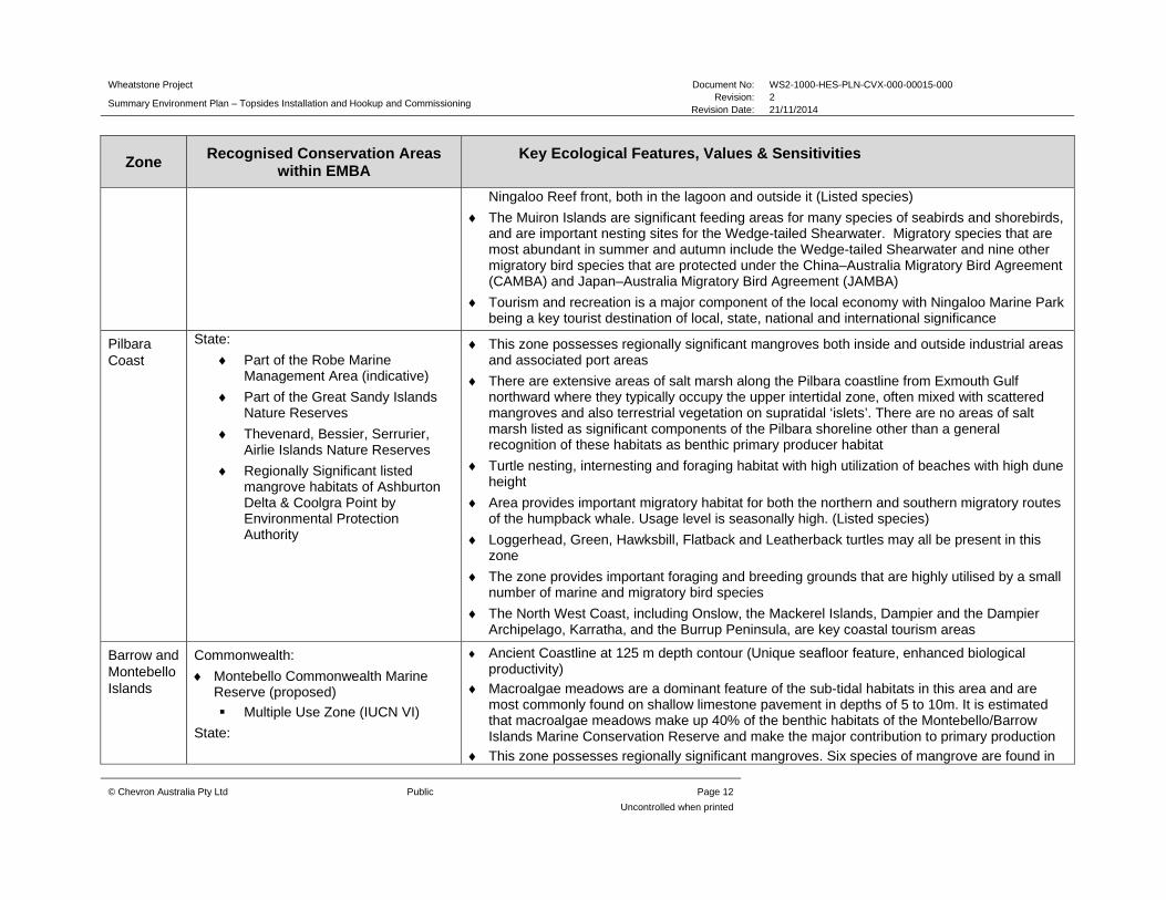
Table 3.1: Areas of conservation significance and key ecological features which occur within the EMBA
Zone Recognised Conservation Areas
within EMBA Key Ecological Features, Values & Sensitivities
Gascoyne Commonwealth:
Gascoyne Commonwealth Marine Reserve
Marine National Park Zone (International Union for Conservation of Nature [IUCN] II)
Habitat Protection Zone (IUCN IV)
Multiple Use Zone (IUCN VI)
Carnarvon Canyon Commonwealth Marine Reserve
Habitat Protection Zone (IUCN IV)
Canyons on the slope between the Cuvier Abyssal Plain and the Cape Range Peninsula (enhanced productivity, aggregations of marine life and unique sea floor feature)
Exmouth Plateau (unique sea-floor feature associated with internal wave generation)
Continental slope demersal fish communities (high species diversity and endemism - the most diverse slope bioregion in Australia with over 500 species found with over 64 of those species occurring nowhere else)
Zone provides important migratory habitat for both the northern and southern migratory routes of the humpback whale. Usage level is seasonally high (Listed species)
Loggerhead and Hawksbill turtle geographic distributions marginally overlap this zone
The zone provides important foraging and breeding grounds that are highly utilised by a diverse number of marine and migratory bird species
Ningaloo International:
Ningaloo Coast World Heritage Area
Commonwealth:
Ningaloo Marine Park (Commonwealth Waters)
Marine National Park Zone (IUCN II)
Recreational Zone (IUCN IV)
State:
Ningaloo Marine Park
Muiron Islands Marine Management Area
Cape Range National Park
Jurabi and Bundegi Coastal Parks
Commonwealth waters adjacent to Ningaloo Reef (Unique seafloor feature, high biodiversity, feeding and breeding aggregations of marine life)
Ningaloo Reef is the largest fringing barrier coral reef, and the second largest coral reef system in Australia. The Ningaloo Coast and Muiron Islands encompass a series of interconnected habitats, from the continental shelf and slope communities of the Commonwealth Waters to the reef and onshore ecosystems of Ningaloo Reef
Limited mangrove communities occur in the northern half of the Ningaloo Marine Park with three species of mangroves identified within the Park
Turtle nesting habitat with high utilization of beaches with high dune height with major turtle rookeries along the Ningaloo and Jurabi coast
Zone provides foraging, breeding, calving and nursing habitat in the shallow protected lagoonal environments fringing the coast and the offshore islands, though not sighted in the comparatively large or dense concentrations seen in the Exmouth Gulf or Shark Bay Areas
Zone provides important migratory habitat for both the northern and southern migratory routes of the humpback whale. Usage level is seasonally high. (Listed species)
Loggerhead, Green, Hawksbill, Flatback, Leatherback and Olive Ridley turtles may all be present in this zone
Whale sharks aggregate in the waters of the Ningaloo Marine Park, frequently close to the
Wheatstone Project Document No: WS2-1000-HES-PLN-CVX-000-00015-000
Summary Environment Plan – Topsides Installation and Hookup and Commissioning Revision: 2
Revision Date: 21/11/2014
© Chevron Australia Pty Ltd Public Page 12
Uncontrolled when printed
Zone Recognised Conservation Areas
within EMBA Key Ecological Features, Values & Sensitivities
Ningaloo Reef front, both in the lagoon and outside it (Listed species)
The Muiron Islands are significant feeding areas for many species of seabirds and shorebirds, and are important nesting sites for the Wedge-tailed Shearwater. Migratory species that are most abundant in summer and autumn include the Wedge-tailed Shearwater and nine other migratory bird species that are protected under the China–Australia Migratory Bird Agreement (CAMBA) and Japan–Australia Migratory Bird Agreement (JAMBA)
Tourism and recreation is a major component of the local economy with Ningaloo Marine Park being a key tourist destination of local, state, national and international significance
Pilbara Coast
State:
Part of the Robe Marine Management Area (indicative)
Part of the Great Sandy Islands Nature Reserves
Thevenard, Bessier, Serrurier, Airlie Islands Nature Reserves
Regionally Significant listed mangrove habitats of Ashburton Delta & Coolgra Point by Environmental Protection Authority
This zone possesses regionally significant mangroves both inside and outside industrial areas and associated port areas
There are extensive areas of salt marsh along the Pilbara coastline from Exmouth Gulf northward where they typically occupy the upper intertidal zone, often mixed with scattered mangroves and also terrestrial vegetation on supratidal ‘islets’. There are no areas of salt marsh listed as significant components of the Pilbara shoreline other than a general recognition of these habitats as benthic primary producer habitat
Turtle nesting, internesting and foraging habitat with high utilization of beaches with high dune height
Area provides important migratory habitat for both the northern and southern migratory routes of the humpback whale. Usage level is seasonally high. (Listed species)
Loggerhead, Green, Hawksbill, Flatback and Leatherback turtles may all be present in this zone
The zone provides important foraging and breeding grounds that are highly utilised by a small number of marine and migratory bird species
The North West Coast, including Onslow, the Mackerel Islands, Dampier and the Dampier Archipelago, Karratha, and the Burrup Peninsula, are key coastal tourism areas
Barrow and Montebello Islands
Commonwealth:
Montebello Commonwealth Marine Reserve (proposed)
Multiple Use Zone (IUCN VI)
State:
Ancient Coastline at 125 m depth contour (Unique seafloor feature, enhanced biological productivity)
Macroalgae meadows are a dominant feature of the sub-tidal habitats in this area and are most commonly found on shallow limestone pavement in depths of 5 to 10m. It is estimated that macroalgae meadows make up 40% of the benthic habitats of the Montebello/Barrow Islands Marine Conservation Reserve and make the major contribution to primary production
This zone possesses regionally significant mangroves. Six species of mangrove are found in

Wheatstone Project Document No: WS2-1000-HES-PLN-CVX-000-00015-000
Summary Environment Plan – Topsides Installation and Hookup and Commissioning Revision: 2
Revision Date: 21/11/2014
© Chevron Australia Pty Ltd Public Page 13
Uncontrolled when printed
Zone Recognised Conservation Areas
within EMBA Key Ecological Features, Values & Sensitivities
Montebello Islands Marine Park
Barrow Island Marine Park
Barrow Island Marine Management Area
Barrow Island Nature Reserve
Barrow Group Nature Reserves
Lowendal Islands Nature Reserves
Montebello Islands Marine Nature Reserves
the reserves, with the Montebello Islands’ mangrove communities considered globally unique as they occur in lagoons of offshore islands
Significant turtle nesting habitat particularly at sandy beaches on Varanus Island, Lowendal Island Group and Barrow Island
Dugongs are frequently recorded in the shallow, warm waters in the vicinity of the Montebello Islands, Lowendal Islands and Barrow Shoals, where they feed on seagrass meadows and algae, though not in the comparatively large or dense concentrations seen further south in the Exmouth Gulf and Shark Bay Areas
This zone provides important migratory habitat for both the northern and southern migratory routes of the humpback whale. Usage level is seasonally high. Female humpback whales and their calves use the sheltered water to the west of Trimouille Island in the Montebello group as a resting area during their southerly migration to feeding grounds in Antarctica (Listed species)
Several dolphin species have resident populations within the Barrow Island area including bottlenose and Indo-pacific humpbacked dolphin (Listed species)
Loggerhead, Green, Hawksbill and Flatback turtles may all be present in this zone
Whale sharks have been recorded foraging seasonally in the zone, however not at significant densities. (Listed species)
The Montebello/Lowendal/Barrow Island region has significant rookeries for 15 seabird species, including the largest breeding colony of Roseate Terns in WA, located on the Montebello Islands
Offshore Not applicable - No marine or coastal conservation areas occur within this zone.
Glomar Shoals (Unique seafloor feature, high biodiversity)
Ancient coastline at 125 m depth contour (Unique seafloor feature, enhanced biological productivity)
Continental slope demersal fish communities (Communities with high species diversity and endemism)
Canyons on the slope between the Cuvier Abyssal Plain and the Cape Range Peninsula (Unique sea floor feature, enhanced biological productivity, aggregations of marine life).
Exmouth Plateau (Unique sea-floor feature)
Zone provides important migratory habitat for both the northern and southern migratory routes of the humpback whale. Usage level is seasonally high (Listed species)
Loggerhead, Green, Hawksbill and Flatback turtles may all be present in this zone

Wheatstone Project Document No: WS2-1000-HES-PLN-CVX-000-00015-000
Summary Environment Plan – Topsides Installation and Hookup and Commissioning Revision: 2
Revision Date: 21/11/2014
© Chevron Australia Pty Ltd Public Page 14
Uncontrolled when printed
Zone Recognised Conservation Areas
within EMBA Key Ecological Features, Values & Sensitivities
This zone overlaps a Biologically Important Area for Whaleshark foraging in deeper waters The zone provides important foraging and breeding habitat that is highly utilised by various
marine and migratory seabirds. Of particular note is the White-Tailed Tropic Bird which is only recorded in two locations in Western Australia
Wheatstone Project Document No: WS2-1000-HES-PLN-CVX-000-00015-000 Summary Environment Plan – Topsides Installation and Hookup and Commissioning
Revision: 2 Revision Date: 21/11/2014
© Chevron Australia Pty Ltd Public Page 15
Uncontrolle
3.3 Socio-Economic Environment
Subsea oil and gas infrastructure and wells exist within the EMBA, however there is no infrastructure such as ports or harbors within the operational area, with the exception of three pipeline crossings occurring within the 500 m buffer either side of the petroleum pipeline licence WA-25-PL.
There are numerous petroleum activities and associated infrastructure offshore in the north-west shelf and also a number of coastal harbours utilised by industry and marine tourism operators and boats ramps throughout the EMBA, primarily used for recreational activities. Vessel traffic in the area is predominantly associated with movements between Indonesia and central-to-southern Western Australian waters.
A number of commercial fisheries operate in the North-west Marine Region. The waters off the Pilbara coast support a number of State managed commercial fisheries including prawn, demersal scalefish, demersal finfish, crab, mackerel, pearl and marine aquarium fish, as well as the Commonwealth managed North West Slope and Western Deepwater Trawl Fisheries and Western Tuna and Billfish Fishery.
The range of recreational fishing opportunities includes estuarine fishing, beach fishing and boat fishing either in embayment’s or offshore for demersal and pelagic/game species often around islands and out to the edge of the continental shelf (DoF, 2012a). Most recreational fishing occurs in State Waters with very few recreational fishers visiting the offshore region where the installation activities will occur due largely to remoteness from land and lack of shallow features.
There is little marine-based tourism and recreational fishing within the operational area, due to the remote location. The north west of WA provides marine-based tourism and recreational opportunities benefiting the Western Australian community, as summarised in Table 3.1. Recreational boating, diving, snorkelling, surfing, and wildlife observation (e.g. whales, dolphins, dugongs, turtles, and birds) occur predominantly throughout the coastal area of the EMBA.
There are no identified areas of cultural heritage or shipwrecks within the operational area.
Wheatstone Project Document No: WS2-1000-HES-PLN-CVX-000-00015-000 Summary Environment Plan – Topsides Installation and Hookup and Commissioning
Revision: 2 Revision Date: 21/11/2014
© Chevron Australia Pty Ltd Public Page 16
Uncontrolle
4.0 ENVIRONMENTAL IMPACTS AND RISKS
All aspects of the activity have been subjected to an impact and risk assessment to understand the potential environmental risks associated with the activity and ensure risks are reduced to as low as reasonably practicable and are of an acceptable level.
Environmental Risk Assessment Workshops were undertaken for topside installation and HUC activities at which the environmental impacts and risks were considered for planned activities or unplanned events including unplanned events related to hydrocarbon spills and spill response activities. The environmental impact identification and risk assessment process comprised the following components:
Identification of activities and events (including planned activities, unplanned events and spill response activities), and associated aspects with the potential to impact identified physical, biological, and socioeconomic receptors
Identification of physical, biological, and socioeconomic receptors within the EMBA by the activities and aspects, and identification of particular environmental values and sensitivities
Evaluation of the potential consequences to the identified receptors without safeguards
Identification of safeguards (controls) to reduce the potential likelihood of the consequence occurring
Evaluation of the likelihood of the consequence occurring with planned and confirmed safeguards in place
Quantification of the risk ranking with safeguards in place
Determination of whether the potential environmental impacts and risks are ALARP after considering the effectiveness of the identified safeguards
Determination of whether the potential environmental impacts and risks are acceptable
Safeguards were identified during the Environmental Risk Workshops to ensure all identified risks were reduced to ALARP and of an acceptable level. Safeguards were considered in terms of both preventing the impact occurring, and mitigating the severity of the consequence, drawing on the hierarchy of controls, identified as Elimination, Substitution, Isolation, Engineering, and Administration and Procedures.
The risk assessment was undertaken in alignment with the processes outlined in Australian Standard/New Zealand Standard (AS/NZS) ISO 31000:2009 Risk Management and HB 203:2012 Managing Environment-Related Risk, using the Chevron Integrated Risk Prioritization Matrix. Of the planned activities and potential unplanned events assessed during the Environmental Risk Workshops, the residual risk rankings with safeguards in place was determined to be low for all activities.
A summary of the environmental risks and impacts and controls in place to manage the activity are detailed in Table 4.1.
Wheatstone Project Document No: WS2-1000-HES-PLN-CVX-000-00015-000
Summary Environment Plan – Topsides Installation and Hookup and Commissioning Revision: 2
Revision Date: 21/11/2014
© Chevron Australia Pty Ltd Public Page 17
Uncontrolled when printed
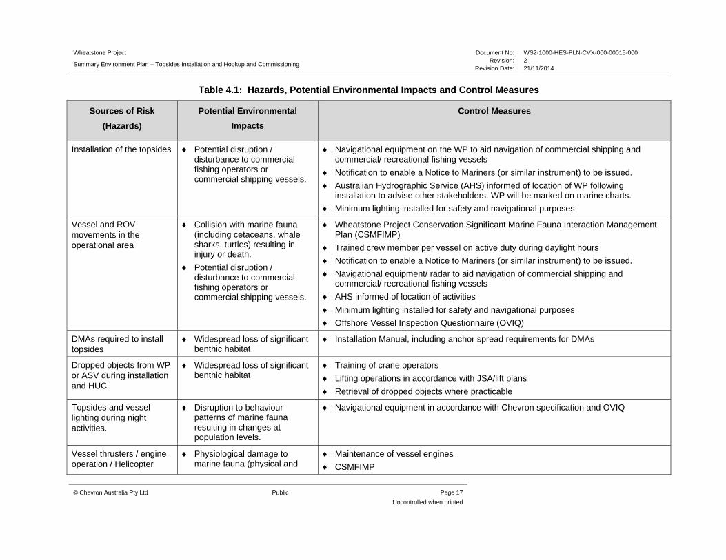
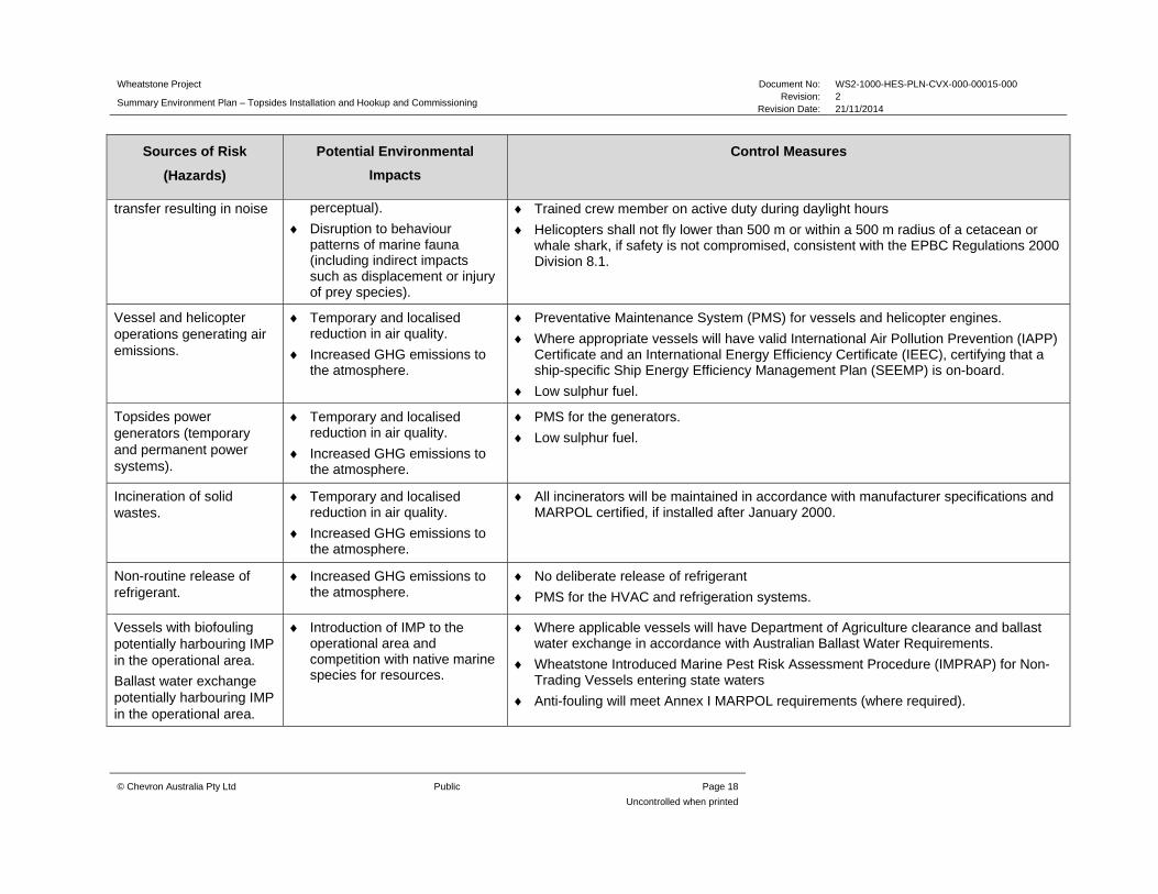
Table 4.1: Hazards, Potential Environmental Impacts and Control Measures
Sources of Risk
(Hazards)
Potential Environmental
Impacts
Control Measures
Installation of the topsides Potential disruption / disturbance to commercial fishing operators or commercial shipping vessels.
Navigational equipment on the WP to aid navigation of commercial shipping and commercial/ recreational fishing vessels
Notification to enable a Notice to Mariners (or similar instrument) to be issued.
Australian Hydrographic Service (AHS) informed of location of WP following installation to advise other stakeholders. WP will be marked on marine charts.
Minimum lighting installed for safety and navigational purposes
Vessel and ROV movements in the operational area
Collision with marine fauna (including cetaceans, whale sharks, turtles) resulting in injury or death.
Potential disruption / disturbance to commercial fishing operators or commercial shipping vessels.
Wheatstone Project Conservation Significant Marine Fauna Interaction Management Plan (CSMFIMP)
Trained crew member per vessel on active duty during daylight hours
Notification to enable a Notice to Mariners (or similar instrument) to be issued.
Navigational equipment/ radar to aid navigation of commercial shipping and commercial/ recreational fishing vessels
AHS informed of location of activities
Minimum lighting installed for safety and navigational purposes
Offshore Vessel Inspection Questionnaire (OVIQ)
DMAs required to install topsides
Widespread loss of significant benthic habitat
Installation Manual, including anchor spread requirements for DMAs
Dropped objects from WP or ASV during installation and HUC
Widespread loss of significant benthic habitat
Training of crane operators
Lifting operations in accordance with JSA/lift plans
Retrieval of dropped objects where practicable
Topsides and vessel lighting during night activities.
Disruption to behaviour patterns of marine fauna resulting in changes at population levels.
Navigational equipment in accordance with Chevron specification and OVIQ
Vessel thrusters / engine operation / Helicopter
Physiological damage to marine fauna (physical and
Maintenance of vessel engines
CSMFIMP
Wheatstone Project Document No: WS2-1000-HES-PLN-CVX-000-00015-000
Summary Environment Plan – Topsides Installation and Hookup and Commissioning Revision: 2
Revision Date: 21/11/2014
© Chevron Australia Pty Ltd Public Page 18
Uncontrolled when printed
Sources of Risk
(Hazards)
Potential Environmental
Impacts
Control Measures
transfer resulting in noise perceptual).
Disruption to behaviour patterns of marine fauna (including indirect impacts such as displacement or injury of prey species).
Trained crew member on active duty during daylight hours
Helicopters shall not fly lower than 500 m or within a 500 m radius of a cetacean or whale shark, if safety is not compromised, consistent with the EPBC Regulations 2000 Division 8.1.
Vessel and helicopter operations generating air emissions.
Temporary and localised reduction in air quality.
Increased GHG emissions to the atmosphere.
Preventative Maintenance System (PMS) for vessels and helicopter engines.
Where appropriate vessels will have valid International Air Pollution Prevention (IAPP) Certificate and an International Energy Efficiency Certificate (IEEC), certifying that a ship-specific Ship Energy Efficiency Management Plan (SEEMP) is on-board.
Low sulphur fuel.
Topsides power generators (temporary and permanent power systems).
Temporary and localised reduction in air quality.
Increased GHG emissions to the atmosphere.
PMS for the generators.
Low sulphur fuel.
Incineration of solid wastes.
Temporary and localised reduction in air quality.
Increased GHG emissions to the atmosphere.
All incinerators will be maintained in accordance with manufacturer specifications and MARPOL certified, if installed after January 2000.
Non-routine release of refrigerant.
Increased GHG emissions to the atmosphere.
No deliberate release of refrigerant
PMS for the HVAC and refrigeration systems.
Vessels with biofouling potentially harbouring IMP in the operational area.
Ballast water exchange potentially harbouring IMP in the operational area.
Introduction of IMP to the operational area and competition with native marine species for resources.
Where applicable vessels will have Department of Agriculture clearance and ballast water exchange in accordance with Australian Ballast Water Requirements.
Wheatstone Introduced Marine Pest Risk Assessment Procedure (IMPRAP) for Non-Trading Vessels entering state waters
Anti-fouling will meet Annex I MARPOL requirements (where required).

Wheatstone Project Document No: WS2-1000-HES-PLN-CVX-000-00015-000
Summary Environment Plan – Topsides Installation and Hookup and Commissioning Revision: 2
Revision Date: 21/11/2014
© Chevron Australia Pty Ltd Public Page 19
Uncontrolled when printed
Sources of Risk
(Hazards)
Potential Environmental
Impacts
Control Measures
Routine discharge of putrescible wastes.
Temporary and localised reduction in water quality associated with increase in nutrients.
Food waste will be discharged in accordance with MARPOL, Annex V.
Accidental loss to the marine environment of generated solid hazardous and non-hazardous wastes.
Temporary and localised reduction in water quality
Ingestion by or entanglement of marine fauna
Appropriate segregation and containment of wastes
Vessels > 100 T (or certified for > 15 persons on-board) will have a Waste Management Plan, in accordance with MARPOL 73/78
Routine discharge of liquid wastes including sewage, cooling water and brine
Localised reduction in water quality resulting in acute and chronic effects on marine flora and fauna
Vessels – Untreated sewage discharged >12 nm from land
A MARPOL compliant sewage treatment system or approved comminution and disinfection system to discharge as required.
Induction training includes appropriate segregation and containment of wastes
Appropriate containment i.e. bunding/secondary containment and topside drainage system
Use of Oily Water Separator (OWS) to meet MARPOL requirements
PMS for systems generating liquid wastes
Unplanned discharge waste oil and chemicals (MEG/TEG)
Localised reduction in water quality resulting in toxicity effects on marine flora and fauna
Bunkering controls i.e. quick release dry break couplings
Storage and management of waste oils and chemicals including liquid nitrogen and liquid helium
Localised reduction in water quality resulting in toxicity effects on marine flora and fauna
Induction training includes appropriate segregation and containment of wastes
Backloading operating aligned with Section 6.8 of the Chevron Marine Operating Procedure,
Hydrocarbon spill from vessels or topsides due to single point failure, transfers, overflow or
Reduction in water quality resulting in toxicity effects on marine flora and fauna
Loss of containment of hydraulic fluid for systems in or above water will be detected by visual inspection, low pressure or low level alarms
PMS for ROVs

Wheatstone Project Document No: WS2-1000-HES-PLN-CVX-000-00015-000
Summary Environment Plan – Topsides Installation and Hookup and Commissioning Revision: 2
Revision Date: 21/11/2014
© Chevron Australia Pty Ltd Public Page 20
Uncontrolled when printed
Sources of Risk
(Hazards)
Potential Environmental
Impacts
Control Measures
dropped object – overboard
Spill kits will be present on topsides and vessels
Biodegradable hydraulic fluid where technically feasible
Lifting operations including JSA/ lift plan
Crane operators trained in lifting operations
Vessel Shipboard Oil Pollution Emergency Plan (SOPEP)
Spill response training and awareness
DMAs, fenders and mating/alignment cones are used during the topsides floatover
Backloading operations in accordance with Section 6.8 Marine Operating Procedures
In the event of a spill, implement the OSORP
Refuelling – MDO spill during vessel refuelling
Reduction in water quality resulting in toxicity effects on marine flora and fauna
Use of dry break couplings / self-sealing quick release couplings
Maintain communications, adhere to weather limitations and provide adequate lighting.
Emergency stop activated on transfer pumps when there is loss of fuel hose pressure.
In the event of a spill, implement the OSORP
Vessel Collision – MDO spill from support vessel (400 m3)
Reduction in water quality resulting in toxicity effects on marine flora and fauna
Competency and training of vessel crews
A valid and in-date OVIQ
Notice to mariners
24-hour visual, radio and radar watch maintained for all vessels
Cyclone Response Plan OE-11.01
ASV gangway managed in accordance with the prevailing wind conditions
Simultaneous operations (SIMOPS) plan when installation vessels are working within 500 m of each other in the operational area
In the event of a spill, implement the OSORP
Implementation of response strategies (source control, monitor and evaluate and containment and
No additional environmental impacts identified to those relating to vessel and aircraft movements etc. described above, and therefore no known
N/A

Wheatstone Project Document No: WS2-1000-HES-PLN-CVX-000-00015-000
Summary Environment Plan – Topsides Installation and Hookup and Commissioning Revision: 2
Revision Date: 21/11/2014
© Chevron Australia Pty Ltd Public Page 21
Uncontrolled when printed
Sources of Risk
(Hazards)
Potential Environmental
Impacts
Control Measures
recovery) in the event of a spill.
potential impacts
Implementation of Assisted Natural Dispersion (AND) in the event of a spill (excluding standard vessel operations)
Increased concentrations of aromatics in water column causing measurable localised impact.
AND not conducted on HFO spill
AND conducted in accordance with OSORP
Implementation of Oil Wildlife Response (OWR)
Hazing wildlife resulting in significant injury to fauna
Hazing conducted in accordance with OSORP
Treatment and cleaning of wildlife resulting in significant injury or death to fauna
Fauna handling training
Fauna exclusion barriers to fauna access to oiled area resulting in significant injury or death to fauna
Booming to be supervised at all times
Any trapped fauna recovered
Waste Management and Disposal.
Insufficient waste management resources inhibit recovery operations.
Poor waste storage and disposal can result in further environmental impacts after clean-up and recovery operations.
Sufficient and appropriate waste containers for expected volume and segregation
All waste material collected offshore, will be segregated, stored, handled, transported and disposed appropriately
OSORP
Establishment of onshore waste collection area.
Decline in sediment quality.
Decline in water quality.
Storage of waste. Decline in sediment quality.
Decline in water quality.

Wheatstone Project Document No: WS2-1000-HES-PLN-CVX-000-00015-000
Summary Environment Plan – Topsides Installation and Hookup and Commissioning Revision: 2
Revision Date: 21/11/2014
© Chevron Australia Pty Ltd Public Page 22
Uncontrolled when printed
Sources of Risk
(Hazards)
Potential Environmental
Impacts
Control Measures
Transport of waste by vessel, and vehicle.
Decline in sediment quality.
Decline in water quality.
Injury to marine fauna.
Injury to terrestrial fauna.
Temporary reduction in air quality.
Tracking of waste to final disposal
Final disposal location is appropriate to waste type.
Wheatstone Project Document No: WS2-1000-HES-PLN-CVX-000-00015-000 Summary Environment Plan – Topsides Installation and Hookup and Commissioning
Revision: 2 Revision Date: 21/11/2014
© Chevron Australia Pty Ltd Public Page 23
Uncontrolled when printed
5.0 MANAGEMENT APPROACH
The implementation strategy identifies the systems, practices and procedures to be used to ensure the environmental impacts and risks of the activities are reduced to ALARP and are acceptable, and the environmental performance outcomes and standards are met. The implementation strategy is split between planned operational activities and unplanned event response, enabling roles and responsibilities to be clearly defined and to provide a clear chain of command for both.
The implementation strategy is to be enacted in accordance with Chevron Australia’s Operational Excellence Management System. Chevron’s Operational Excellence Management System is aligned to ISO 14001:2004 and key components of the management system are described in the subsections below.
5.1 Roles and Responsibilities
Accountabilities and responsibilities are defined for personnel involved in the projects implementation for both planned activities and emergency conditions.
5.2 Training and Competency
All personnel are required to attend environmental inductions and training relevant to their role for the activities. Training and induction programs facilitate the understanding personnel have of their environmental responsibilities, and increase their awareness of the management and protection measures required to reduce potential impacts on the environment. In addition to project training, personnel will also receive spill response training.
5.3 Monitoring and Reporting
The implementation strategy outlines the requirements for the following:
marine fauna observations oil spill monitoring plan emissions and discharges, and routine external reporting and non-routine reporting (including internal incident
reporting and investigations and external incident and near misses reporting).
5.4 Compliance assurance
A multi-tiered environmental compliance assurance program will be implemented for the duration of the activities described in the detailed Plan, including tools, processes and procedures to deliver and verify compliance with the EP. Assurance activities will include both Chevron-led and contractor-led audits and inspections. Chevron-led audits and inspections will be undertaken as required and in accordance with Chevron’s ABU Compliance Assurance Process and the Health, Environment and Safety Audit Schedule for the Project.
5.5 Documentation and Records
Chevron Australia’s ABU Operational Excellence Management System (OEMS) has dedicated information management tools and processes to ensure critical information is developed, accessible and maintained by the workforce. Wheatstone documentation shall be managed in accordance with this process, and specifically via the Project’s Document Management System. Accordingly, all documentation and records demonstrating compliance against environmental performance objectives and standards will be effectively maintained and retained for the life of the Project and not less than five years.

Wheatstone Project Document No: WS2-1000-HES-PLN-CVX-000-00015-000 Summary Environment Plan – Topsides Installation and Hookup and Commissioning
Revision: 2 Revision Date: 21/11/2014
© Chevron Australia Pty Ltd Public Page 24
Uncontrolled when printed
5.6 Environment Plan Review
Chevron’s Management of Change process will be followed to document and assess the impact of any changes to the activities described in the EP. These changes will be addressed to determine if there is potential for any new or increased environmental impact or risk not already provided for in the EP. Where required the EP will be re-submitted to NOPSEMA for approval in accordance with Regulation 17 of the Offshore Petroleum and Greenhouse Gas Storage (Environment) Regulations 2009 (OPGGS(E)R).

Wheatstone Project Document No: WS2-1000-HES-PLN-CVX-000-00015-000 Summary Environment Plan – Topsides Installation and Hookup and Commissioning
Revision: 2 Revision Date: 21/11/2014
© Chevron Australia Pty Ltd Public Page 25
Uncontrolled when printed
6.0 OIL SPILL OPERATIONAL RESPONSE PLAN
To mitigate against oil spill scenarios an Oil Spill Operational Response Plan has been developed specific to the topsides installation and HUC activities. The OSORP addresses the specific response measures and procedures that would be implemented to minimise the impact of an oil spill. The OSORP interfaces with Chevrons broader emergency response framework and management systems.
The OSORP adopts a tiered response philosophy to oil spill responses, which is consistent with that adopted by the National Marine Oil Spill Contingency Plan (AMSA 2005) and the WA Marine Oil Pollution Emergency Management Plan (Department of Planning and Infrastructure 2007).
The OSORP contains the necessary information and details the response capability required to respond to the worst case credible spill event identified from topsides installation and HUC activities which has been determined to be a Marine Diesel Oil (MDO) spill due to vessel collision, maximum spill volume of 400 m3 based on largest fuel volume stored on vessels related to these activities. Modelling of this scenario (and other smaller credible spill scenarios) are the basis of the environment that may be affected (EMBA) which is described in Section 3.0. The spill response strategies described within the OSORP focus on the identified resources at risk within the EMBA.
The credible spill scenarios that were considered in the EP and are able to be managed within the framework of the OSORP include;
Hydraulic oil due to single point failure (overboard spills of <1 m3 of hydraulic oil) Hydrocarbon spills from the topsides (overboard spills of <135 m3 of diesel, lubricant
oil and heating medium) MDO spill due to vessel refuelling (1.2 m3 – inventory of transfer hose) MDO spill due to vessel refuelling (25 m3 – failure of dry break couplings) MDO spill due to vessel collision of ASV, ICV, topsides installation barge or PSVs
(maximum spill volume of 400 m3 based on largest fuel volume stored on vessels)
The OSORP is designed to be an operational document to ensure a rapid and appropriate response in the unlikely event of an oil spill and provides guidance on:
Specific response strategies to be adopted for scenarios specific to the topsides installation and HUC activities
Practical information required to undertake a rapid and effective response Co-ordination of external resources through AMOSC, AMSA, or the WA Department
of Transport (DoT).
The following spill response strategies have been assessed as applicable for potential hydrocarbon spill events related to the topsides installation and HUC activities:
Source Control Monitor, Evaluate and Surveillance (MES) Containment and Recovery (if feasible) Assisted Natural Dispersion (AND) Oiled Wildlife Response (OWR) Waste Management.
In accordance with Protection of the Sea (Prevention of Pollution from Ships) Act 1983 (11A), a current SOPEP or equivalent for vessels >400 T will be kept on-board. In the event

Wheatstone Project Document No: WS2-1000-HES-PLN-CVX-000-00015-000 Summary Environment Plan – Topsides Installation and Hookup and Commissioning
Revision: 2 Revision Date: 21/11/2014
© Chevron Australia Pty Ltd Public Page 26
Uncontrolled when printed
of a marine pollution incident from a vessel, the vessel’s SOPEP will be enacted and Chevron will be alerted via the OSORP. The response operation will be under the umbrella of the OSORP, with Chevron taking control of the situation, including escalation of Level if required. Both SOPEPs and the OSORP contain update and review provisions to address necessary changes. The OSORP is tested at least annually.
Wheatstone Project Document No: WS2-1000-HES-PLN-CVX-000-00015-000 Summary Environment Plan – Topsides Installation and Hookup and Commissioning
Revision: 2 Revision Date: 21/11/2014
© Chevron Australia Pty Ltd Public Page 27
Uncontrolled when printed
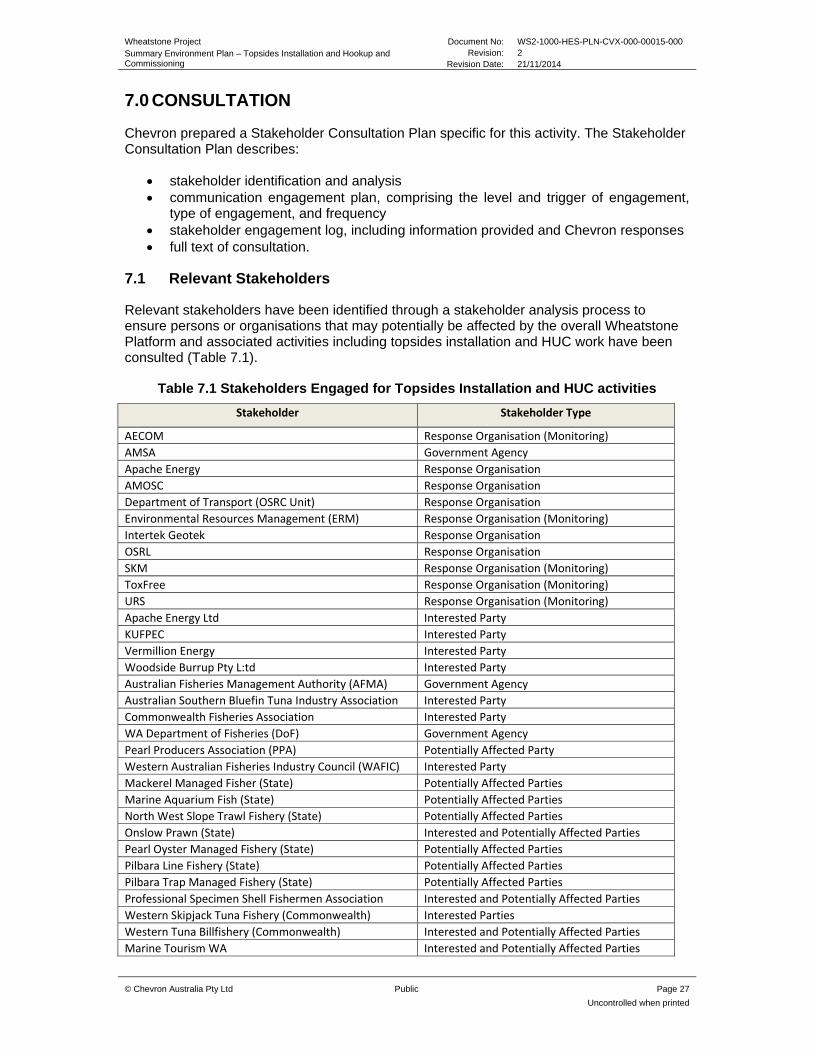
7.0 CONSULTATION
Chevron prepared a Stakeholder Consultation Plan specific for this activity. The Stakeholder Consultation Plan describes:
stakeholder identification and analysis communication engagement plan, comprising the level and trigger of engagement,
type of engagement, and frequency stakeholder engagement log, including information provided and Chevron responses full text of consultation.
7.1 Relevant Stakeholders
Relevant stakeholders have been identified through a stakeholder analysis process to ensure persons or organisations that may potentially be affected by the overall Wheatstone Platform and associated activities including topsides installation and HUC work have been consulted (Table 7.1).
Table 7.1 Stakeholders Engaged for Topsides Installation and HUC activities
Stakeholder Stakeholder Type
AECOM Response Organisation (Monitoring)
AMSA Government Agency
Apache Energy Response Organisation
AMOSC Response Organisation
Department of Transport (OSRC Unit) Response Organisation
Environmental Resources Management (ERM) Response Organisation (Monitoring)
Intertek Geotek Response Organisation
OSRL Response Organisation
SKM Response Organisation (Monitoring)
ToxFree Response Organisation (Monitoring)
URS Response Organisation (Monitoring)
Apache Energy Ltd Interested Party
KUFPEC Interested Party
Vermillion Energy Interested Party
Woodside Burrup Pty L:td Interested Party
Australian Fisheries Management Authority (AFMA) Government Agency
Australian Southern Bluefin Tuna Industry Association Interested Party
Commonwealth Fisheries Association Interested Party
WA Department of Fisheries (DoF) Government Agency
Pearl Producers Association (PPA) Potentially Affected Party
Western Australian Fisheries Industry Council (WAFIC) Interested Party
Mackerel Managed Fisher (State) Potentially Affected Parties
Marine Aquarium Fish (State) Potentially Affected Parties
North West Slope Trawl Fishery (State) Potentially Affected Parties
Onslow Prawn (State) Interested and Potentially Affected Parties
Pearl Oyster Managed Fishery (State) Potentially Affected Parties
Pilbara Line Fishery (State) Potentially Affected Parties
Pilbara Trap Managed Fishery (State) Potentially Affected Parties
Professional Specimen Shell Fishermen Association Interested and Potentially Affected Parties
Western Skipjack Tuna Fishery (Commonwealth) Interested Parties
Western Tuna Billfishery (Commonwealth) Interested and Potentially Affected Parties
Marine Tourism WA Interested and Potentially Affected Parties

Wheatstone Project Document No: WS2-1000-HES-PLN-CVX-000-00015-000 Summary Environment Plan – Topsides Installation and Hookup and Commissioning
Revision: 2 Revision Date: 21/11/2014
© Chevron Australia Pty Ltd Public Page 28
Uncontrolled when printed
RecFishwest Interested and Potentially Affected Parties
Australian Hydrographic Service (AHS) Government Agency
Dept of Broadband Communication and the Digital Economy
Government Agency
Dept of Defence Government Agency
Depart of Mines and Petroleum (DMP) Government Agency
Dept Parks and Wildlife Government Agency
Dept of Transport Government Agency
Port Authority Dampier Government Agency
NOPSEMA Government Agency
7.2 Stakeholder Engagement Outcomes
No objections or claims about adverse impacts relating directly to the activity (installation of topsides and hook up and commissioning of the Platform) were raised by relevant stakeholders. Some feedback has been received and clarifications have been requested and Chevron has responded appropriately to ensure queries were adequately addressed and resolved. Information obtained from the consultation process was considered in the development of the Environment Plan, where relevant, and a summary of feedback and clarifications is provided in Table 7.2 .
Table 7.2 Summary of consultation and Chevrons response
Stakeholder Feedback Chevron Response
Stakeholder noted the location of activities and potential traffic in the area related to other operations and requested notification prior to commencement of activities
Chevron noted this response and confirmed it would contact the appropriate authority prior to commencement of activities
Multiple stakeholders reviewed the OSORP and provided advice on their capability to respond
Chevron agreed to send final OSORPS to relevant stakeholders once accepted and updated capability requirements where necessary.
Stakeholder noted the following:
Activities are potentially in, or in close proximity to areas associated with commercial fisheries
Chevron has contacted licenced fishers directly and provided fact sheets
Customary, recreational and charter fishing may occur in the area
Chevron has contacted relevant stakeholders directly about the activity
Recommended CVX initiate and maintain consultation with fishers and their representative bodies prior to activities commencing
As above and Chevron will advise start and finish dates to rep bodies as agreed
Requested that they be notified in the event of an oil spill within 24 hours of an incident being reported to relevant authority
Chevron has updated the contact details in the plan to ensure notification
Request that CVX consider baseline data collation as part of the development of the Spill Contingency plan as per the Operational Scientific Monitoring Program (OSMP) guidance developed by NOPSEMA
An activity specific Oil Spill Operational Response Plan (OSORP) and OSMP has been developed as part of accepted EP, including an outline of the baseline data which CVX may use for comparison in the unlikely event of a spill from this activity
Requested that spawning grounds and nursery area be considered in the EP
Key spawning grounds and nursery areas were considered in the EP
Requested that discharges that have the potential to temporarily disrupt fishing
Discharges that have the potential to impact the environment are recorded and managed in accordance
Wheatstone Project Document No: WS2-1000-HES-PLN-CVX-000-00015-000 Summary Environment Plan – Topsides Installation and Hookup and Commissioning
Revision: 2 Revision Date: 21/11/2014
© Chevron Australia Pty Ltd Public Page 29
Uncontrolled when printed
activities be recorded and managed to an approved standard
with the accepted EP
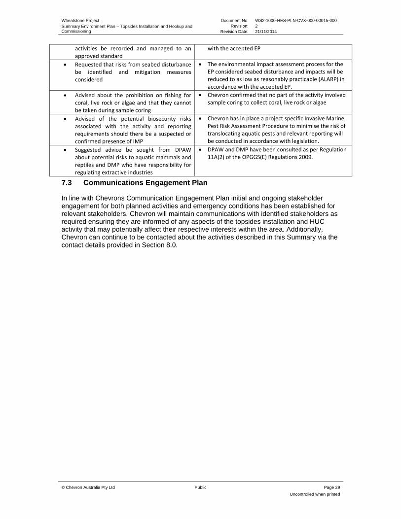
Requested that risks from seabed disturbance be identified and mitigation measures considered
The environmental impact assessment process for the EP considered seabed disturbance and impacts will be reduced to as low as reasonably practicable (ALARP) in accordance with the accepted EP.
Advised about the prohibition on fishing for coral, live rock or algae and that they cannot be taken during sample coring
Chevron confirmed that no part of the activity involved sample coring to collect coral, live rock or algae
Advised of the potential biosecurity risks associated with the activity and reporting requirements should there be a suspected or confirmed presence of IMP
Chevron has in place a project specific Invasive Marine Pest Risk Assessment Procedure to minimise the risk of translocating aquatic pests and relevant reporting will be conducted in accordance with legislation.
Suggested advice be sought from DPAW about potential risks to aquatic mammals and reptiles and DMP who have responsibility for regulating extractive industries
DPAW and DMP have been consulted as per Regulation 11A(2) of the OPGGS(E) Regulations 2009.
7.3 Communications Engagement Plan
In line with Chevrons Communication Engagement Plan initial and ongoing stakeholder engagement for both planned activities and emergency conditions has been established for relevant stakeholders. Chevron will maintain communications with identified stakeholders as required ensuring they are informed of any aspects of the topsides installation and HUC activity that may potentially affect their respective interests within the area. Additionally, Chevron can continue to be contacted about the activities described in this Summary via the contact details provided in Section 8.0.
Wheatstone Project Document No: WS2-1000-HES-PLN-CVX-000-00015-000 Summary Environment Plan – Topsides Installation and Hookup and Commissioning
Revision: 2 Revision Date: 21/11/2014
© Chevron Australia Pty Ltd Public Page 30
Uncontrolled when printed
8.0 CONTACT DETAILS
Further information associated with the proposed activities may be obtained from:
Andy Turner
Wheatstone Upstream HES Manager
Phone: +61 8 9216 4952
Fax: +61 8 9413 6885
Email: [email protected]