Embed Size (px)
Citation preview
99
KEYWORDS
ISSN: 0974 - 0376
NSave Nature to Survive
: Special issue, Vol. III:
www.theecoscan.inAN INTERNATIONAL QUARTERLY JOURNAL OF ENVIRONMENTAL SCIENCES
Prof. P. C. Mishra Felicitation Volume
Paper presented in
National Seminar on Ecology, Environment &Development
25 - 27 January, 2013
organised by
Deptt. of Environmental Sciences,
Sambalpur University, Sambalpur
Guest Editors: S. K. Sahu, S. K. Pattanayak and M. R. Mahananda
C. S. K. Mishra and Monalisa Rath
Waste land
Deforestation
Salination
Desertification
Mine spoil
Reclamation
99 - 105; 2013
WASTELAND RECLAMATION: NOVEL APPROACHES

100
C. S. K. MISHRA* AND MONALISA RATH1
Department of Zoology, Orissa University of Agriculture and Technology,
College of Basic Sciences and Humanities, Bhubaneswar - 751 0031Department of Soil Science and Agricultural Chemistry, Orissa University of Agriculture and Technology,
College of Agriculture, Bhubaneswar - 751 003
E-mail: [email protected]
INTRODUCTION
Land, a non-renewable resource, is central to all primary production systems.
Over the years, the landmass has suffered from different types of degradations.
Degradation of land is caused by biotic and abiotic pressures. Waste land is eco
logically unstable, whose top soil has been nearly completely lost and which
have developed toxicity in root zones for growth of most plants, both annual
crop and trees (Bhumbla and Khare, 1984). Land degradation or deterioration of
land quality for agricultural production and environmental protection has been a
matter of concern for land users. Land degradation assessment undertaken by the
various Central and State agencies resulted in the generation of databases on the
degraded and wastelands. But these agencies had used varying definitions of
land degradation, data sources, classification systems, methodologies and scales
that resulted in diverse estimates of degraded and wasteland areas (Table 1). A
vast area of land all over the world has been rendered unproductive by human
activities (Choi and Wali, 1995).
The National Remote Sensing Agency (NRSA) followed remote-sensing technology,
identifying land-use and physical condition of the surface features for mapping
non-agricultural areas (presently non-arable) on 1: 50,000 scale using satellite
image of late rabi season with adequate field checks (Table 2).
Major causes of wasteland formation
The various purposes, for which land can be used, include agriculture and
horticulture for food production, energy production, human dwelling and
industrial/commercial purpose. But its overuse makes it unfit for human use. The
National Wasteland Development Board (NWDB) has classified wastelands into
two categories, culturable and unculturable. Culturable wastelands are those
lands which have potential for the development of vegetative cover or reclaimed
in later stage. These lands remain unproductive for various reasons such as water
logging, salinity, non-availability of water or aridity and unfavourable terrain, etc.
Large waste land areas are found in hills, arid, ravine and flood-prone areas of
north western Himalayan states like Jammu and Kashmir, Himachal Pradesh,
North Eastern states, Rajasthan, Uttar Pradesh, Bihar and Madhya Pradesh.
Unculturable wastelands are those lands which cannot be developed for
vegetative cover. These lands are barren and cannot be put to significant uses.
However, some of the areas of such lands can be converted/ changed into pasture
land. These lands are deserted areas near snowline areas with high degree to
slope, etc. Non culturable wasteland can be turned into grasslands which can
improve the ecological balance by protecting soil from rapid erosion and soil
moisture decline. It can also enhance supplies of fodder and fuel at the same
time. Thus, it can support pastoral activities, which is one of the areas of major
concern in India.
Wastelands include degraded forests, overgrazed pastures, drought struck
pastures, eroded valleys, hilly slopes, waterlogged marshy lands, barren land etc.
NSave Nature to Survive QUARTERLY
Highly fertile landmass might be converted in
to unproductive wasteland due to a number
of natural and anthropogenic causes such as
over utilization of forests, overgrazing,
salination, desertification, unscientific land
management etc. In India, vast stretches of
land covering many states have been reduced
to sterile land. With ever increasing demand
for agricultural land and afforestation
programmes, there is an urgent need to make
large bulk of this wasteland productive and
fertile. This is only feasible through sustainable
scientific methods of reclamation. Reclamation
is the process by which derelict or highly
degraded lands are returned to productivity
and by which some measure of biotic function
and productivity is restored. This paper
reviews the major causes of wasteland
generation and some of the feasible methods
of their eco restoration.
ABSTRACT
*Corresponding author

101
WASTELAND RECLAMATION
Agency Estimated Criteria for delineation
extent (M ha)
National Commission on Agriculture (NCA, 1976) 148.09 Based on the secondary data
Ministry of Agriculture (1978) 175.00 Based on the NCA’s estimates. No systematic survey was undertaken
(Soil and Water Conservation Division)
Society for Promotion of Wastelands Development 129.58 Based on the secondary estimates
(SPWD) (Bhumbla and Khare, 1984)
NRSA (1985) 53.28 Mapping on 1 : 1 million scale based on the remote-sensing techniques
Ministry of Agriculture (MOA, 1985) 173.64 Land degradation statistics for states
Ministry of Agriculture (MOA, 1994) 107.43 Elimination of duplication of area. Area reclaimed counted
NBSS&LUP (1994) 187.70 Mapping on 1 : 4 million scale based on the Global Assessment of Soil
Degradation (GLASOD) guidelines
NBSS&LUP (2004) (revised) 146.82 1 : 1 million scale soil map
Department of Environment (Vohra, 1980) 95.00
National Wasteland Development Board (1985) 123.00
Source: Gautam, N.C. and Narayan, L.R.A. 1988
Table 1: Land degradation assessment by different organizations
Wasteland class Area (in km2) Percentage
Gullied/ravinous land (Medium) 7005.47 1.48
Gullied/ravinous land (Deep) 1714.80 0.36
Land with dense scrub 93372.62 19.77
Land with open scrub 91645.83 19.41
Waterlogged/marshy land (permanent) 2532.46 0.54
Waterlogged/marshy land (seasonal) 2994.22 0.63
Land affected by salinity/ alkalinity (medium) 5451.63 1.15
Land affected by salinity/ alkalinity (strong) 1737.81 0.37
Shifting cultivation area current jhum 5625.07 1.19
Shifting cultivation area abandoned jhum 4608.44 0.98
Under utilized degraded forest land (scrub domain.) 85787.78 18.17
Under utilized degraded forest land (agriculture) 16381.53 3.47
Degraded pastures/grazing land 7197.14 1.52
Degraded land under plantation crop 314.14 0.07
Sands riverine 2439.86 0.52
Coastal sand 719.31 0.15
Desertic sand 5280.07 1.12
Sands semi stabilized to stabilized (>40 m) 11188.21 2.37
Sands semi stabilized to stabilized (15-40 m) 15627.63 3.31
Mining wasteland 506.58 0.11
Industrial wasteland 63.09 0.01
Barren rocky/stony/sheet rock 69372.54 14.69
Snow covered/glacial area 40694.80 8.62
Total wasteland area in 2008-09 4767021.16
Source: National remote sensing application centre, ISRO, Hyderabad
Table 2: NRSA wasteland classes (2008-09)
Figure 1: Wasteland regions in India
Very large wasteland areas
Large wasteland areas
Medium wasteland areas
The main causes of wasteland formation are
i) Indiscriminate and over utilization of forest produce.
ii) Overgrazing of grasslands.
iii) Salination and Water logging
iv) Desertification.
v) Side-effects of development projects (misuse and
unscientific land management) e.g. industrial and mining
activity.
Wasteland categories
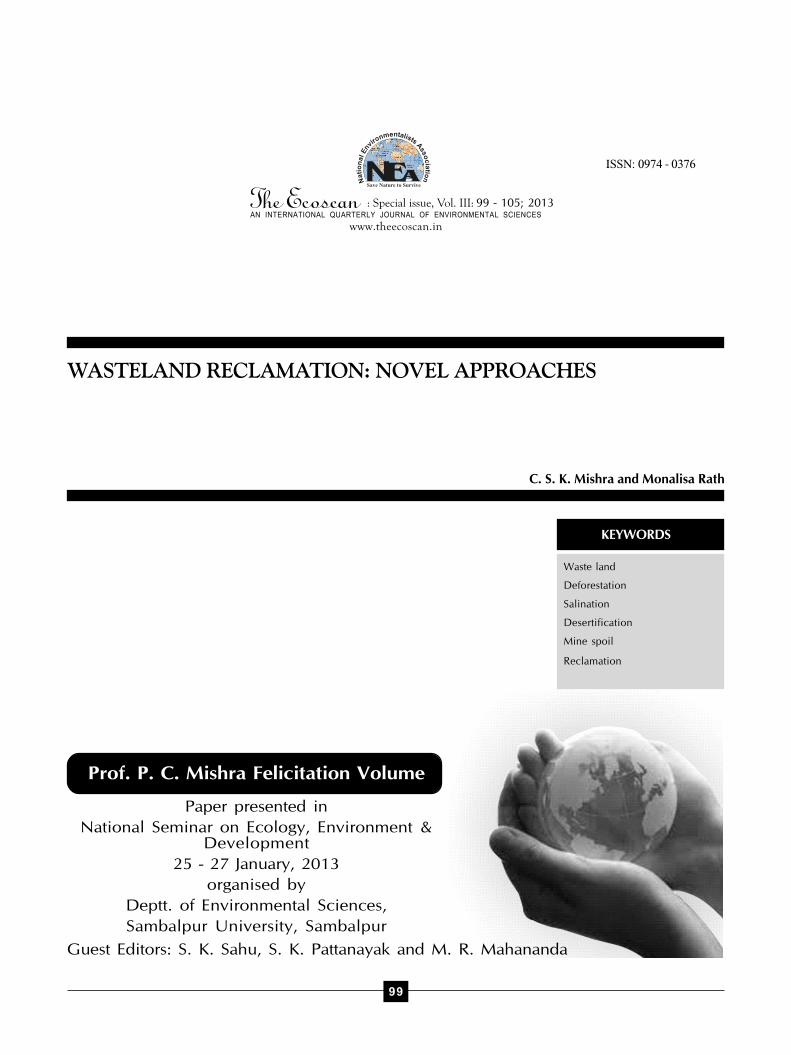
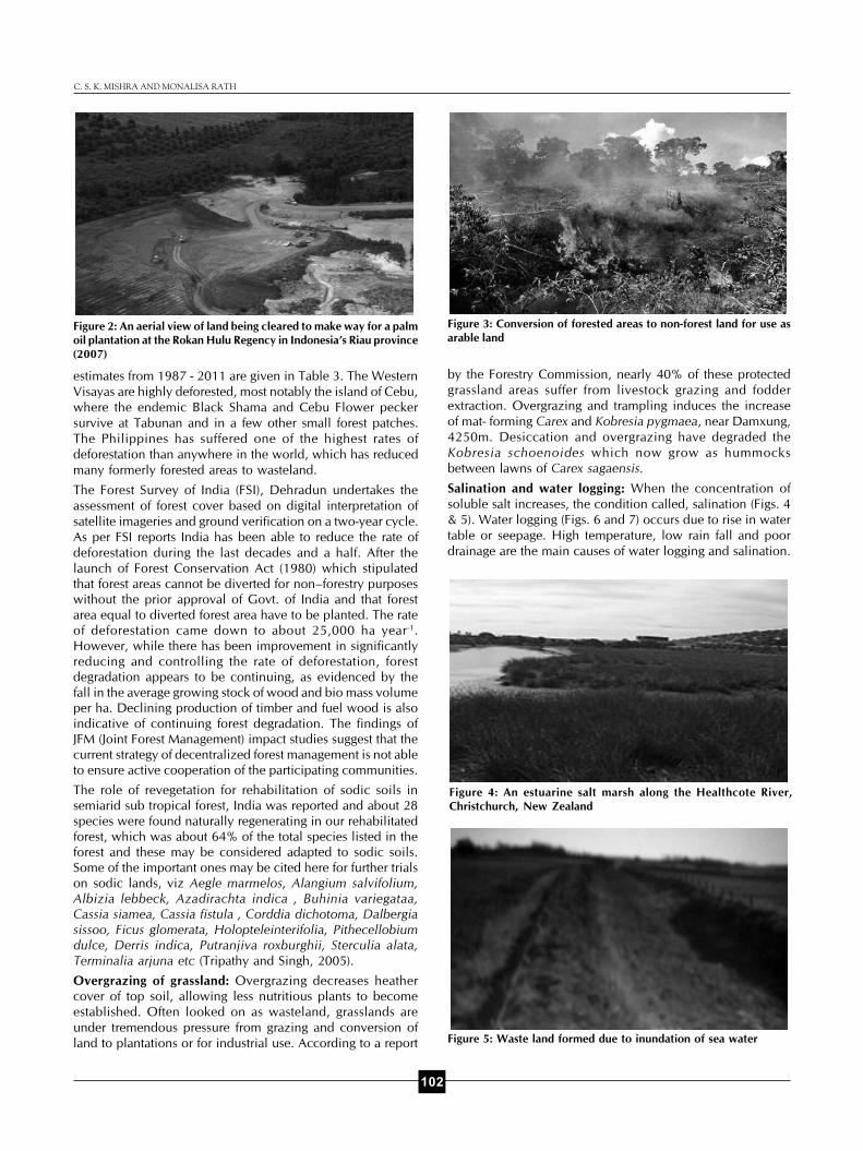
Degraded forest: Deforestation results in permanent
conversion of forests by the method of postures, shifting,
cultivating, agricultural land and regular cutting of trees (Figs.
2 and 3). The situation is particularly alarming in tropical areas
where forest loss and degradation, as well as degradation of
land those earlier supported forests, are proceeding at
unprecedented rates (Parrotta et al., 1997). The forest cover
102
C. S. K. MISHRA AND MONALISA RATH
estimates from 1987 - 2011 are given in Table 3. The Western
Visayas are highly deforested, most notably the island of Cebu,
where the endemic Black Shama and Cebu Flower pecker
survive at Tabunan and in a few other small forest patches.
The Philippines has suffered one of the highest rates of
deforestation than anywhere in the world, which has reduced
many formerly forested areas to wasteland.
The Forest Survey of India (FSI), Dehradun undertakes the
assessment of forest cover based on digital interpretation of
satellite imageries and ground verification on a two-year cycle.
As per FSI reports India has been able to reduce the rate of
deforestation during the last decades and a half. After thelaunch of Forest Conservation Act (1980) which stipulatedthat forest areas cannot be diverted for non–forestry purposeswithout the prior approval of Govt. of India and that forestarea equal to diverted forest area have to be planted. The rateof deforestation came down to about 25,000 ha year -1.However, while there has been improvement in significantlyreducing and controlling the rate of deforestation, forestdegradation appears to be continuing, as evidenced by thefall in the average growing stock of wood and bio mass volumeper ha. Declining production of timber and fuel wood is alsoindicative of continuing forest degradation. The findings ofJFM (Joint Forest Management) impact studies suggest that thecurrent strategy of decentralized forest management is not ableto ensure active cooperation of the participating communities.
The role of revegetation for rehabilitation of sodic soils insemiarid sub tropical forest, India was reported and about 28species were found naturally regenerating in our rehabilitatedforest, which was about 64% of the total species listed in theforest and these may be considered adapted to sodic soils.Some of the important ones may be cited here for further trialson sodic lands, viz Aegle marmelos, Alangium salvifolium,Albizia lebbeck, Azadirachta indica , Buhinia variegataa,Cassia siamea, Cassia fistula , Corddia dichotoma, Dalbergiasissoo, Ficus glomerata, Holopteleinterifolia, Pithecellobiumdulce, Derris indica, Putranjiva roxburghii, Sterculia alata,Terminalia arjuna etc (Tripathy and Singh, 2005).
Overgrazing of grassland: Overgrazing decreases heathercover of top soil, allowing less nutritious plants to becomeestablished. Often looked on as wasteland, grasslands are
under tremendous pressure from grazing and conversion of
land to plantations or for industrial use. According to a report
Figure 2: An aerial view of land being cleared to make way for a palm
oil plantation at the Rokan Hulu Regency in Indonesia’s Riau province
(2007)
Figure 3: Conversion of forested areas to non-forest land for use as
arable land
Figure 5: Waste land formed due to inundation of sea water
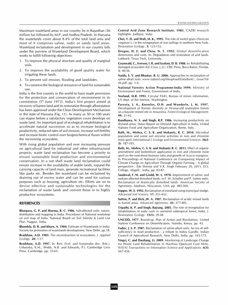
Figure 4: An estuarine salt marsh along the Healthcote River,
Christchurch, New Zealand
by the Forestry Commission, nearly 40% of these protected
grassland areas suffer from livestock grazing and fodder
extraction. Overgrazing and trampling induces the increase
of mat- forming Carex and Kobresia pygmaea, near Damxung,
4250m. Desiccation and overgrazing have degraded the
Kobresia schoenoides which now grow as hummocks
between lawns of Carex sagaensis.
Salination and water logging: When the concentration of
soluble salt increases, the condition called, salination (Figs. 4
& 5). Water logging (Figs. 6 and 7) occurs due to rise in water
table or seepage. High temperature, low rain fall and poor
drainage are the main causes of water logging and salination.

103
without grinding in factory, it is cheaper. Gypsum chamber is
a brick-cement-concrete chamber, the size of which depends
primarily on tube well discharge and sodicity (RSC) of the
water. This chamber is connected to water fall chamber to
one side and to water channel on the other side. A net of iron
bars covered with wire net (2mm x 2mm) is fitted at a height of
10 cm from the bottom of the bed on which the gypsum clodsare filled up. With little modification, farmers can easily convert
their water fall chamber into gypsum chamber.
An area of land of Auroville, coastal Tamilnadu, India of 135
acres of alkaline shallow (0.5 to 1m) heavily eroded black
cotton soil was made available for an experiment in
regeneration. On roughly one-third of this land a white crust
of 1 to 3 cm was observable. Another third had a thinner
white crust. Here and there on the remaining area, cracks
appeared on the land every summer. The soil pH was found
to range between 7.2 and 8.5. The E.C. ranged from 1,500 to
2,300 mmhos/cm. An attempt was initially made to plant
various recommended indigenous and exotic species. Pits of
1.5 ft x 1.5 ft were dug to loosen the soil and filled up with the
same earth. No soil amendments were used. Six-month-old
seedlings were then planted. The species included:
Enterelobium dulce, Prosopis julifera, Albizzia lebbeck,
Azadirachta indica, Pongamia glabra, Leucaena leucocephala,
Acacia leucophloea, Cassia siamea. Though weeds from the
locality can be used for regenerating heavily eroded black
cotton soils, the experiment showed that hardier species of
perhaps trees and shrubs were needed to start a process of
regeneration in the most degraded portions of the land.
Desertification: Desertification has been defined by the United
Nations Environment Programme (UNEP) as land degradation
in arid, semi-arid and dry sub-humid areas resulting mainly
Figure 6: Massive water logging in a field in UP, India Figure 7: In UP, consequent to water logging, there is more wasteland
and less agriculture area
Minerals in the soils and exposed rocks of the earth’s crust
produce soluble salts. Good agriculture lands turn saline every
year in Punjab, India. The first report on salt affected wasteland
formation in connection with irrigation practices come from
Haryana in 1958. It has been reported that several villages of
Rohtak, Panipat and Delhi lying near western area of Yamuna
canal are suffering from destructive saline effloresces. Sea watercan salinize coastal areas, particularly where violent sweep
on shores or even when sea breezes blow salt-spray inland
(so called cyclic salts). For instance, on some areas along the
sea coasts in Maharashtra, Kerala, Tamil Nadu, Andhra
Pradesh and West Bengal, salinity of soil is usually caused by
annual inundation with sea water.
The reclamation of saline-alkali soils is receiving increased
attention in India (Sandoval and Gould, 1978; Bhargava and
Sharma, 1986; Yadav, 1987). Many arid and semi-arid regions
have extensive salt-affected soils that undergo further
salinization from agricultural practices that trap and concentrate
dissolved salts.
Use of Gypsum Chamber technology for reclaiming sodic
waters (Naidu and Bhaskar, 2006) constitute a considerable
proportion of the total underground water resources which is
predominant in the arid and semi arid regions of North-Western
India and also Deccan Plateau. Conventionally, sodic hazards
of these waters is mitigated by applying and mixing uniformly
the powdered gypsum in a leveled field and than flooding
with fresh water, well before the sowing of crop. A new method
developed by CSSRI, Karnal and H.A.U., Hissar is relatively
more economical and efficient. The technology is called
Gypsum chamber technology in which water is made to pass
through a chamber of gypsum and water dissolved calcium
sulphate is applied to soils. As gypsum can be used in clods
Figure 9: Quarry formed in an Iron mine
area in Joda, OdishaFigure 10: Waste land formed due to iron ore
mining in Keonjhar, OdishaFigure 8: Surface copper hill, East Tamilnadu
WASTELAND RECLAMATION

104
from adverse human impact. This 1991 definition is a revision
of the definition formulated at the 1977 United Nations
Conference on Desertification. The 1977 definition described
desertification as the diminution or destruction of the biological
potential of the land, which could lead ultimately to the
formation of desert-like conditions (UNCOD, 1977). The
principal criterion for placing land in one of the four
desertification classes (slight, moderate, severe, very severe)
was the impact degradation has had on economic plant yield,
on both croplands and rangelands (Dregne and Chau, 1992).
Slight, moderate, and severe degradation usually are reversible;
very severely degraded land is categorized as land which
cannot be rehabilitated economically. Globally, Australia has
the greatest amount of dry lands, none of it hyperarid. The
U.S.S.R. ranked second, again with no hyperarid territory,
followed by China, the United States, and Saudi Arabia. Over
half of Saudi Arabia is hyperarid.
Dryland agriculture is often the principal kind of farming thatis practised in the arid and semi-arid regions of the world.Water for plant growth and development is supplied entirelyby rainfall. Randhawa and Singh (1986) categorize drylandfarming areas in India as those with a moisture-available periodof less than 120 days, receiving 100-600 mm of precipitationin summer and winter months. In the area near Jodhpur(Rajasthan, India), about 370 mm of precipitation is receivedin 20 days spread over about 11 weeks (CAZRI, 1985). Theprobability of severe drought in this area has been calculatedto be about 40010. The region is currently experiencing aprolonged drought as monsoon rains received during the threesummers, 1985-1987, have been erratic, infrequent, andconsiderably below normal. About 35% of China’s agriculturalland affected by desertification.
Side-effects of development projects e.g. industrial andmining activity: Directly or indirectly, industrialization andthe rising human population have given rise to many humanactivities that contribute to the cause of wasteland formation.Mining (Fig. 8, 9 and 10) typically has serious, negative effectson the ecology, at all levels of organization, from microbial tolandscape (Yingyi and Daoliang, 2009) and play a major rolein forming the waste land. Ecosystem destruction by mining,quarrying for minerals and other processes to meet demandsof industries, is an inevitable part of civilization (Bradshaw,1983). In the process of removing desired mineral material,the original vegetation is inevitably destroyed and soil is lostor buried by wastes (Bradshaw, 1997). Strip mining can causecompaction, changes in soil texture, loss of soil structure andreduced water infiltration (Grunwald et al., 1988; Norland,
1993). Un-reclaimed or poorly reclaimed lands are oftenbarren, because problematic soil material left on the surfaceafter mining would not support plant growth (Sutton and Dick,1987). This creates problems, as waste dumps are subject toerosion and leaching if left un-vegetated. The authors havedone extensive survey on the generation of spoil in the ironand chromite mining belt of Joda Barbil area in the Keonjhardistrict of Odisha. Studies have indicated the poor fertilitystatus of spoil dumps with significantly low microbialpopulation and soil enzyme activities. Results have alsoindicated considerably low soil respiration and plant growthparameters in the spoil with respect to control soil (Rath et al.,2010, 2011).
Reclamation approach: There are many approaches to land
and vegetation rehabilitation. These depend on severity of
damage to the land resource, the goals of rehabilitation and
availability of resources for repairing the damage. The most
intensive rehabilitation is sometimes termed reclamation,
because the damage to sites is so severe that soils have to be
replaced and landscapes may have to be reshaped.
Reclamation is the process by which derelict or highly
degraded lands are returned to productivity, and by which
some measure of biotic function and productivity is restored.
Long term mine spoil reclamation requires the establishment
of stable nutrient cycles from plant growth and microbial
processes (Sopper, 1992). However reclamation process often
becomes arrested because of severe limitations in the site or
the biota. Reclamation or restoration can be thought as a
continuum of outcomes from the least to the most similar to
the pre-disturbance ecosystem.
C. S. K. MISHRA AND MONALISA RATH
Table 3: The forest cover estimates in India
Year of state of forest report Data period Forest tree cover km2 % of Geographical area Dense forest %
1987 1981-83 640, 819 19.49 59.06
1989 1983-85 638,804 19.43 60.27
1991 1987-89 639,364 19.45 60.31
1993 1989-91 639,386 19.45 60.30
1995 1991-93 638,879 19.43 60.27
1997 1993-95 633,397 19.27 57.98
1999 1996-98 637,293 19.39 59.21
2001 1998-99 23.03
2003 2000-01 23.68
2011 2008-09 782,871 23.89
Source: FSI-SFR 1987-2003, Dehradun, India
Figure 12: India’s first project aimed at recovery of barren land and
its restoration through afforestation has been approved under the
Clean Development Mechanism in the state of Haryana
105
Maximum wasteland areas in our country lie in Rajasthan (36
million ha) followed by M.P. and Andhra Pradesh. In Haryana
the wastelands cover about 8.4% of the total land area and
most of it comprises saline, sodic or sandy land areas.
Wasteland reclamation and development in our country falls
under the purview of Wasteland Development Board, which
works to fulfill following objectives:
1. To improve the physical structure and quality of marginal
soils.
2. To improve the availability of good quality water for
irrigating these lands.
3. To prevent soil erosion, flooding and landslides.
4. To conserve the biological resources of land for sustainable
use.
India is the first country in the world to have made provisions
for the protection and conservation of environment in its
constitution (5th June 1972). India’s first project aimed at
recovery of barren land and its restoration through afforestation
has been approved under the Clean Development Mechanism
in the state of Haryana (Fig. 11). As many as 50 or 100 years
can elapse before a satisfactory vegetation cover develops on
waste land. An important goal of ecological rehabilitation is to
accelerate natural succession so as to increase biological
productivity, reduced rates of soil erosion, increase soil fertility
and increase biotic control over biogeochemical fluxes within
the recovering ecosystem.
With rising global population and ever increasing pressure
on agricultural land for industrial and other infrastructural
projects, waste land reclamation has become a priority to
ensure sustainable food production and environmental
conservation. In a nut shell waste land reclamation could
ensure increase in the availability of arable lands, expand the
carrying capacity of land mass, generate recreational facilities
like parks etc. Besides the wasteland can be reclaimed by
draining out of excess water and can be used for various
purposes such as housing, agriculture etc. Efforts are on to
devise effective and sustainable technologies for the
reclamation of waste lands and convert those in to highly
productive ecosystems.
REFERENCES
Bhargava, G. P. and Sharma, R. C. 1986. Salt-affected soils- nature,
distribution and mapping in India. Procedures of National workshop
on soil map of India. National Board on Soil Salinity & Land Use
Plan. Nagpur. India.
Bhumbla, D. R. and Khare, A. 1984. Estimate of Wastelands in India.
Society for promotion of wastelands development, New Delhi. pp.18.
Bradshaw, A.D. 1983. The reconstruction of ecosystems. J. Applied
Ecology. 20: 1-17.
Bradshaw, A.D. 1997. In: Rest. Ecol. and Sustainabe dev. (Eds.).
Urbanska, K.M., Webb, N.R. and Edwards, P.I. Cambridge Univ
Press, Cambridge. pp. 33-65.
Central Arid Zone Research Institute. 1985. CAZRI research
highlights. Jodhpur, India.
Choi, Y. D. and Wali, M. K., 1995. The role of switch grass (Panicum
virgatum L.) in the revegetation of iron tailings in northern New York.
Restoration Ecology. 3: 123-132.
Dregne, H. E. and Chou, N. T. 1992. Global desertification
dimensions and costs. In: Degradation and restoration of arid lands.
Lubbock: Texas Tech. University.
Grunwald, C., Iverson, I. R. and Szafoni, D. B. 1988. In: Rehabilitatingdamaged ecosystem (Ed. Cirus, J, Jr.). CRC Press, Boca Raton, Florida.1: 40-56.
Naidu, E. V. and Bhaskar, B. U. 2006. Approaches to reclamation ofsaline alkali soils. www.nabard.org/fileupload/DataBank/.../issue7td-06.pdf. pp. 1-4.
National Forestry Action Programme-India 1999. Ministry ofEnvironment and Forest, Government of India.
Norland, M.R. 1993. Circular 9345, Bureau of mines information,US dept. of the Interior, Washington.
Parrota, J. A., Knowles, O.H. and Wunderle, J. M. 1997.Development of floristic diversity in 10-year-old restoration forestson a bauxite mined site in Amazonia. Forest Ecological Management.99: 21-42.
Randhawa, N. S. and Singh, R.P. 1986. Increasing productivity ondryland areas. Status Report on Dryland Agriculture in India, UnitedNations Food and Agriculture Organization, Rome, Italy.
Rath, M., Mishra, C. S. K. and Mohanty, R. C. 2010. Microbialpopulation and some soil enzyme activities in iron and chromitemine spoil. International J. Ecology and Environmental Sciences. 36(2-3): 187-193.
Rath, M., Mishra, C. S. K. and Mohanty R. C. 2011. Effect of organicamendment and biofertilizer application in iron and chromite minespoil on the root-shoot biomass ratio and growth of Acacia mangium.In Proceedings of National Conference on Conquering Impact ofClimate Change on Agriculture Through Organic Farming – A globalperspective . Eds Shweta and V.K. Singh February 20, 2011, D.S.College, Aligarh , India, pp. 83-87.
Sandoval, F. M. and Gould, W. L. 1978. Improvement of saline- andsodium·affected disturbed lands, in F. W. Schaller and P. Sutton (eds).Reclamation of drastically disturbed lands. American Society ofAgronomy, Madison, Wisconsin, USA. pp. 485-504.
Sopper, W. E. 1992. Reclamation of mineland using municipal sludge.Advanced Soil Science. 17: 351-432.
Sutton, P. and Dick.,W. A. 1987. Reclamation of acidic mined landsin humid areas. Advanced Agronomy. 41: 377-405.
Tripathi, K. P. and Singh, Bajrang. 2005. The role of revegetation forrehabilitation of sodic soils in semiarid subtropical forest, India. J.Restoration Ecology. 13(1): 29-38.
UNCOD, 1977. Round-up, Plan of Action and Resolutions. UnitedNations Conference on Desertification, Nairobi, Kenya. pp. 43.
Yadav, J. S. P. 1987. Reclamation of saline-alkali soils. An era of self-sufficiency in food production - a tribute to Indira Gandhi. IndianCouncil of Agricultural Research, New Delhi, India. pp. 165-173.
Yingyi, C. and Daoliang, Li. 2009. Monitoring of Landscape Changefor Waste Land Rehabilitation in Haizhou Opencast Coal Mine.WSEAS Transactions on Information Science and Applications. 6(3):447-456.
WASTELAND RECLAMATION

106