Embed Size (px)
Citation preview
Upper Snake Recovery Unit Implementation Plan for Bull Trout (Salvelinus confluentus)
U.S. Fish & Wildlife Service
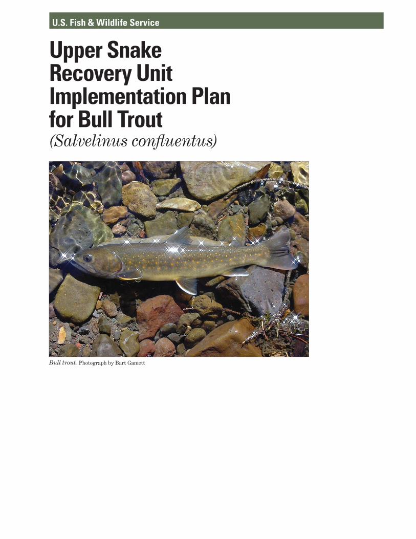
Bull trout. Photograph by Bart Gamett

Upper Snake Recovery Unit
Implementation Plan
for
Bull Trout (Salvelinus confluentus)
September 2015
Prepared by
U.S. Fish and Wildlife Service
Idaho Fish and Wildlife Office
Boise, Idaho

i
Table of Contents
Introduction .................................................................................................................................. E-1
Current Status of Bull Trout in the Upper Snake Recovery Unit ................................................ E-2
Factors Affecting Bull Trout in the Upper Snake Recovery Unit ............................................. E-10
Ongoing Upper Snake Recovery Unit Conservation Measures (Summary) ............................. E-19
Research, Monitoring, and Evaluation ....................................................................................... E-20
Recovery Measures Narrative .................................................................................................... E-21
Implementation Schedule for the Upper Snake Recovery Unit ................................................. E-55
References .................................................................................................................................. E-84
Appendix I. Core Area Summaries ........................................................................................... E-87
Appendix II. Summary of the Comments on the Draft Recovery Unit Implementation Plan for the Upper Snake Recovery Unit ......................................................................................... E-110
List of Figures
Figure E-1. Map of the Upper Snake Recovery Unit for bull trout. ........................................... E-3

ii
List of Tables
Table E-1. Bull trout Population Summary by Major Geographic Regions within Upper Snake
Recovery Unit ........................................................................................................... E-4 Table E-2. Summary of Bull Trout Status by Core Area within Upper Snake Recovery Unit. . E-5
Table E-3. Primary Threats for the Upper Snake Recovery Unit (by Core Area) ................... E-15
Table E-4. Upper Snake Recovery Unit Implementation Schedule ......................................... E-60
E-1
Upper Snake Recovery Unit
Implementation Plan
Introduction This recovery unit implementation plan (RUIP) describes the threats to bull trout and the
site-specific management actions necessary for recovery of the species within the Upper Snake Recovery Unit, including estimates of time required and cost. This document supports and complements the Recovery Plan for the Coterminous United States Population of Bull Trout (USFWS 2015a), which describes recovery criteria and a general range-wide recovery strategy for the species. Detailed discussion of species status and recovery actions within each of the six recovery units are provided in six RUIPs that have been developed in coordination with State, Federal, Tribal, and other conservation partners. This document incorporates our responses to public comment on the Draft Upper Snake RUIP (USFWS 2015b) received during the comment period from June 4 to July 20, 2015 (Appendix II).
The Upper Snake Recovery Unit includes portions of central Idaho, northern Nevada, and eastern Oregon. Major drainages include the Salmon River, Malheur River, Jarbidge River, Little Lost River, Boise River, Payette River, and the Weiser River. The Upper Snake Recovery Unit contains 22 bull trout core areas (Figure E-1) within 7 geographic regions or major watersheds: Salmon River (10 core areas, 123 local populations), Boise River (2 core areas, 29 local populations), Payette River (5 core areas, 25 local populations), Little Lost River (1 core area, 10 local populations), Malheur River (2 core areas, 8 local populations), Jarbidge River (1 core area, 6 local populations), and Weiser River (1 core area, 5 local populations) (Table E-1). The Upper Snake Recovery Unit includes a total of 206 local populations, with almost 60 percent being present in the Salmon River watershed.
Three major bull trout life history expressions are present in the Upper Snake Recovery Unit, adfluvial1, fluvial2, and resident3 populations. Large areas of intact habitat exist primarily in the Salmon drainage, as this is the only drainage in the Upper Snake Recovery Unit that still flows directly into the Snake River; most other drainages no longer have direct connectivity due
1 Adfluvial: Life history pattern of spawning and rearing in tributary streams and migrating to lakes or reservoirs to mature. 2 Fluvial: Life history pattern of spawning and rearing in tributary streams and migrating to larger rivers to mature. 3 Resident: Life history pattern of residing in tributary streams for the fish’s entire life without migrating.
E-2
to irrigation uses or instream barriers. Bull trout in the Salmon basin share a genetic past with bull trout elsewhere in the Upper Snake Recovery Unit. Historically, the Upper Snake Recovery Unit is believed to have largely supported the fluvial life history form; however, many core areas are now isolated or have become fragmented watersheds, resulting in replacement of the fluvial life history with resident or adfluvial forms. The Weiser River, Squaw Creek, Pahsimeroi River, and North Fork Payette River core areas contain only resident populations of bull trout.
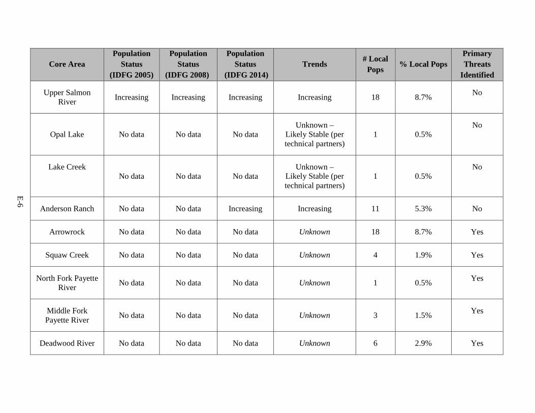
Current Status of Bull Trout in the Upper Snake Recovery Unit The breakdown of core areas by geographic region and the overall status of bull trout
populations within the Upper Snake Recovery Unit are summarized in Tables E-1 and E-2. A description of bull trout status within each geographic region follows below; descriptions of current bull trout status and distribution for each individual core area are given in Appendix I below.
Salmon River
The Salmon River basin represents one of the few basins that are still free-flowing down to the Snake River. The core areas in the Salmon River basin do not have any major dams and a large extent (approximately 89 percent) is federally managed, with large portions of the Middle Fork Salmon River and Middle Fork Salmon River - Chamberlain core areas occurring within the Frank Church River of No Return Wilderness. Most core areas in the Salmon River basin contain large populations with many occupied stream segments. The Salmon River basin contains 10 of the 22 core areas in the Upper Snake Recovery Unit and contains the majority of the occupied habitat. Over 70 percent of occupied habitat in the Upper Snake Recovery Unit occurs in the Salmon River basin as well as 123 of the 206 local populations. Connectivity between core areas in the Salmon River basin is intact; therefore it is possible for fish in the mainstem Salmon to migrate to almost any Salmon River core area or even the Snake River. Connectivity within Salmon River basin core areas is mostly intact except for the Pahsimeroi River and portions of the Lemhi River. The Upper Salmon River, Lake Creek, and Opal Lake core areas contain adfluvial populations of bull trout, while most of the remaining core areas contain fluvial populations; only the Pahsimeroi contains strictly resident populations. Most core areas appear to have increasing or stable trends but trends are not known in the Pahsimeroi, Lake Creek, or Opal Lake core areas. The Idaho Department of Fish and Game reported trend data from 7 of the 10 core areas. This trend data indicated that populations were stable or increasing in the Upper Salmon River, Lemhi River, Middle Salmon River-Chamberlain, Little

Figure E-1. Map of the Upper Snake Recovery Unit for bull trout.
E-3

Table E-1. Bull trout population summary by major geographic regions within the Upper Snake Recovery Unit.
Geographic Region # Core Areas # Local Populations
% Local Pops
In Recovery Unit
Occupied Habitat in
Recovery Unit
% Federally Managed
(USFWS 2002a, 2004a)
Salmon River 10 123 59.7% 70% 89%
Boise River 2 29 14.1% 12% 62%
Payette River 5 25 12.1% <9% 60%
Little Lost River 1 10 4.9% <3% 89%
Malheur River 2 8 3.9% <3% 60%
Jarbidge River 1 6 2.9% 3% 89%
Weiser River 1 5 2.4% <2% 44%
E-4
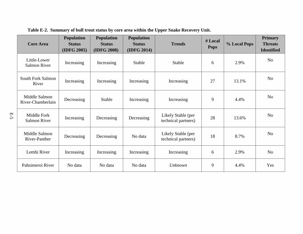
Table E-2. Summary of bull trout status by core area within the Upper Snake Recovery Unit.
Core Area Population
Status (IDFG 2005)
Population Status
(IDFG 2008)
Population Status
(IDFG 2014) Trends # Local
Pops % Local Pops
Primary Threats
Identified
Little-Lower Salmon River Increasing Increasing Stable Stable 6 2.9% No
South Fork Salmon River Increasing Increasing Increasing Increasing 27 13.1% No
Middle Salmon River-Chamberlain Decreasing Stable Increasing Increasing 9 4.4% No
Middle Fork Salmon River Increasing Decreasing Decreasing Likely Stable (per
technical partners) 28 13.6% No
Middle Salmon River-Panther Decreasing Decreasing No data Likely Stable (per
technical partners) 18 8.7% No
Lemhi River Increasing Increasing Increasing Increasing 6 2.9% No
Pahsimeroi River No data No data No data Unknown 9 4.4% Yes
E-5
Core Area Population
Status (IDFG 2005)
Population Status
(IDFG 2008)
Population Status
(IDFG 2014) Trends # Local
Pops % Local Pops
Primary Threats
Identified
Upper Salmon River Increasing Increasing Increasing Increasing 18 8.7% No
Opal Lake No data No data No data Unknown –
Likely Stable (per technical partners)
1 0.5% No
Lake Creek No data No data No data
Unknown – Likely Stable (per technical partners)
1 0.5% No
Anderson Ranch No data No data Increasing Increasing 11 5.3% No
Arrowrock No data No data No data Unknown 18 8.7% Yes
Squaw Creek No data No data No data Unknown 4 1.9% Yes
North Fork Payette River No data No data No data Unknown 1 0.5% Yes
Middle Fork Payette River No data No data No data Unknown 3 1.5% Yes
Deadwood River No data No data No data Unknown 6 2.9% Yes
E-6
Core Area Population
Status (IDFG 2005)
Population Status
(IDFG 2008)
Population Status
(IDFG 2014) Trends # Local
Pops % Local Pops
Primary Threats
Identified
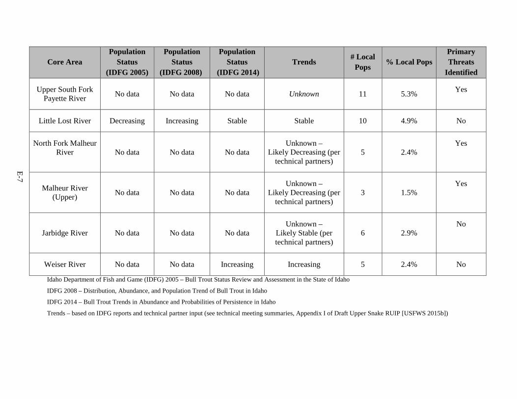
Upper South Fork Payette River No data No data No data Unknown 11 5.3% Yes
Little Lost River Decreasing Increasing Stable Stable 10 4.9% No
North Fork Malheur River No data No data No data
Unknown – Likely Decreasing (per
technical partners) 5 2.4%
Yes
Malheur River (Upper) No data No data No data
Unknown – Likely Decreasing (per
technical partners) 3 1.5%
Yes
Jarbidge River No data No data No data Unknown –
Likely Stable (per technical partners)
6 2.9% No
Weiser River No data No data Increasing Increasing 5 2.4% No
Idaho Department of Fish and Game (IDFG) 2005 – Bull Trout Status Review and Assessment in the State of Idaho
IDFG 2008 – Distribution, Abundance, and Population Trend of Bull Trout in Idaho
IDFG 2014 – Bull Trout Trends in Abundance and Probabilities of Persistence in Idaho
Trends – based on IDFG reports and technical partner input (see technical meeting summaries, Appendix I of Draft Upper Snake RUIP [USFWS 2015b])
E-7
E-8
Lost River, and the South Fork Salmon River (IDFG 2005, 2008, 2014). Trends were stable or decreasing in the Little-Lower Salmon River, Middle Fork Salmon River, and the Middle Salmon River-Panther (IDFG 2005, 2008, 2014).
Boise River
In the Boise River basin, two large dams are impassable barriers to upstream fish movement: Anderson Ranch Dam on the South Fork Boise River, and Arrowrock Dam on the mainstem Boise River. Fish in Anderson Ranch Reservoir have access to the South Fork Boise River upstream of the dam. Fish in Arrowrock Reservoir have access to the North Fork Boise River, Middle Fork Boise River, and lower South Fork Boise River. The Boise River basin contains 2 of the 22 core areas in the Upper Snake Recovery Unit. The core areas in the Boise River basin account for roughly 12 percent of occupied habitat in the Upper Snake Recovery Unit and contain 29 of the 206 local populations. Approximately 90 percent of both Arrowrock and Anderson Ranch core areas are federally owned; most lands are managed by the Forest Service, with some portions occurring in designated wilderness areas. Both the Arrowrock core area and the Anderson Ranch core area are isolated from other core areas. Both core areas contain fluvial bull trout that exhibit adfluvial characteristics and numerous resident populations. The Idaho Department of Fish and Game in 2014 determined that the Anderson Ranch core area had an increasing trend while trends in the Arrowrock core area is unknown (IDFG 2014).
Payette River
The Payette River basin contains three major dams that are impassable barriers to fish: Deadwood Dam on the Deadwood River, Cascade Dam on the North Fork Payette River, and Black Canyon Reservoir on the Payette River. Only the Upper South Fork Payette River and the Middle Fork Payette River still have connectivity, the remaining core areas are isolated from each other due to dams. Both fluvial and adfluvial life history expression are still present in the Payette River basin but only resident populations are present in the Squaw Creek and North Fork Payette River core areas. The Payette River basin contains 5 of the 22 core areas and 25 of the 206 local populations in the recovery unit. Less than 9 percent of occupied habitat in the recovery unit is in this basin. Approximately 60 percent of the lands in the core areas are federally owned and the majority is managed by the Forest Service. Trend data are lacking and the current condition of the various core areas is unknown, but there is concern due to the current isolation of three (North Fork Payette River, Squaw Creek, Deadwood River) of the five core areas; the presence of only resident local populations in two (North Fork Payette River, Squaw Creek) of the five core areas; and the relatively low numbers present in the North Fork core area.
E-9
Jarbidge River
The Jarbidge River core area contains two major fish barriers along the Bruneau River: the Buckaroo diversion and C. J. Strike Reservoir. Bull trout are not known to migrate down to the Snake River. There is one core area in the basin, with populations in the Jarbidge River; this watershed does not contain any barriers. Approximately 89 percent of the Jarbidge core area is federally owned. Most lands are managed by either the Forest Service or Bureau of Land Management. A large portion of the core area is within the Bruneau-Jarbidge Wilderness area. A tracking study has documented bull trout population connectivity among many of the local populations, in particular between West Fork Jarbidge River and Pine Creek. Movement between the East and West Fork Jarbidge River has also been documented; therefore both resident and fluvial populations are present. The core area contains six local populations and 3 percent of the occupied habitat in the recovery unit. Trend data are lacking within this core area.
Little Lost River
The Little Lost River basin is unique in that the watershed is within a naturally occurring hydrologic sink and has no connectivity with other drainages. A small fluvial population of bull trout may still exist, but it appears that most populations are predominantly resident populations. There is one core area in the Little Lost basin, and approximately 89 percent of it is federally owned by either the Forest Service or Bureau of Land Management. The core area contains 10 local populations and less than 3 percent of the occupied habitat in the recovery unit. The current trend condition of this core area is likely stable, with most bull trout residing in Upper Sawmill Canyon (IDFG 2014).
Malheur River
The Malheur River basin contains major dams that are impassable to fish. The largest are Warm Springs Dam, impounding Warm Springs Reservoir on the mainstem Malheur River, and Agency Valley Dam, impounding Beulah Reservoir on the North Fork Malheur. The dams result in two core areas that are isolated from each other and from other core areas. Local populations in the two core areas are limited to habitat in the upper watersheds. The Malheur River basin contains 2 of the 22 core areas and 8 of the 206 local populations in the recovery unit. Fluvial and resident populations are present in both core areas while adfluvial populations are present in the North Fork Malheur. This basin contains less than 3 percent of the occupied habitat in the recovery unit, and approximately 60 percent of lands in the two core areas are federally owned. Trend data indicates that populations are declining in both core areas.
E-10
Weiser River
The Weiser River basin contains local populations that are limited to habitat in the upper watersheds. The Weiser River basin contains only a single core area that consists of 5 of the 206 local populations in the recovery unit. Local populations occur in only three stream complexes in the upper watershed: 1) Upper Hornet Creek, 2) East Fork Weiser River, and 3) Upper Little Weiser River. These local populations include only resident life histories. This basin contains less than 2 percent of the occupied habitat in the recovery unit, and approximately 44 percent of lands are federally owned. Trend data from the Idaho Department of Fish and Game indicate that the populations in the Weiser core area are increasing (IDFG 2014) but it is considered vulnerable because local populations are isolated and likely do not express migratory life histories.
Changes to Recovery Unit
Two notable changes to core area descriptions and boundaries within the Upper Snake Recovery Unit have occurred since the 2002 Draft Recovery Plan for Bull Trout. These changes include the removal of the Lucky Peak core area and the splitting of the Malheur core area. The Lucky Peak core area that was identified in 2002 has since been determined to be a population sink with limited reproduction. Genetic testing has determined that the individuals in Lucky Peak are identical to individuals from Arrowrock, and review of information indicates that the current population in the Lucky Peak core area is sustained artificially through entrainment (USFWS 2008). Thus, we have concluded it should no longer be identified as a core area. In addition, based on updated genetic information (DeHaan et al. 2007), two genetically distinct groups of bull trout exist within the Malheur River basin. Therefore, the former Malheur core area in Oregon was divided into two separate core areas, the Upper Malheur core area and the North Fork Malheur core area.
Factors Affecting Bull Trout in the Upper Snake Recovery Unit Most threats to bull trout, as described in various documents including State plans (e.g.,
Montana Bull Trout Restoration Team 2000; Batt 1996), the draft recovery plans (USFWS 2002a, 2002b, 2004b, 2004c), the critical habitat rules (USFWS 2002a, 2004a, 2010), the updated Bull Trout Core Area Templates (USFWS 2005b, 2008), the Bull Trout Core Area Conservation Status Assessment (USFWS 2005c), and the 2014/2015 technical partner meetings (see Appendix I of Draft Upper Snake RUIP [USFWS 2015b]), fall into the category of destruction, modification, or curtailment of habitat. Most of these impacts (e.g., dewatering,
E-11
sedimentation, thermal modification, and water quality degradation) are human-caused and are a consequence of specific land and water management activities.
For the purpose of this RUIP, we are identifying three broad threat categories: 1) Habitat Threats, 2) Demographic Threats, and 3) Nonnative Fish Threats. Habitat Threats are those that impact bull trout habitat (habitat fragmentation and degradation resulting from upland/riparian land management and instream impacts), Demographic Threats are those that impact individuals or populations (connectivity impairment and small population size), while Nonnative Fish Threats result from effects of introduced fish species or their management that impact individuals or populations (competition, predation, and hybridization).
Habitat Threats and Demographic Threats are likely the major limiting factors for bull trout in the Upper Snake Recovery Unit. These factors affect individuals and local populations as well as habitat for the species. Although in some basins reservoirs formed by dams have allowed bull trout to express adfluvial life histories, dams, irrigation diversions, and road crossings have also formed impassable barriers to fish movement within the basins, further fragmenting habitats and isolating bull trout. Land management activities that degrade aquatic and riparian habitats by altering stream flows and riparian vegetation, such as water diversions, past and current mining operations, timber harvest and road construction, and improper grazing practices, have negatively affected bull trout in several areas of the recovery unit.
Bull trout are also subject to negative interactions with nonnative brook trout in some streams. Brook trout populations are prevalent throughout the Upper Snake Recovery Unit; this species has been identified as a significant threat to bull trout in some core areas. In some local populations and core areas, bull trout abundance appears to be related to brook trout competition and hybridization. Low abundance of bull trout appears to be related to high road density, sedimentation, passage barriers, and brook trout.
Primary Threats
In the final bull trout recovery plan (USFWS 2015a) we have updated the known threats identified in the previous draft recovery plans (USFWS 2002a, 2002b, 2004b, 2004c), with specific focus on threats at the individual core area level, where threats operatively impact bull trout local populations and limit their recovery potential. A threat was considered a primary threat if the threat affected the persistence of a local population and eventually the persistence of a core area. In December 2014, the Service also invited technical partners to several meetings to discuss the threats to bull trout in each of the 22 core areas in the Upper Snake Recovery Unit, with the intent of identifying primary threats (see summary of meetings in Appendix I of Draft Upper Snake RUIP [USFWS 2015b]).

E-12
We evaluated whether a threat should be considered a primary threat by considering information from technical partners, the current status and distribution of populations, known trend information, and existing conservation measures. We weighted information from technical partners heavily in our evaluations. Core areas that all partners determined had no primary threats were identified as having no primary threats. In certain core areas technical partners determined that there were no primary threats based on best professional assessment of core area condition and environment (e.g., remote wilderness regions with few known environmental impacts) although trend data may have been negative (see Table E-2, Middle Fork Salmon River and Middle Salmon River - Panther) or not available (see Table E-2, Lake Creek, Opal Lake, and Jarbidge). For all other core areas we have identified the primary threats that are present, in cooperation with our technical partners, and incorporating information we have received in public comments. A list of primary threats is provided in Table E-3 below. Appendix I provides core area specific summaries of bull trout status, incorporating information received from partners.
Climate Change
Global climate change, and the related warming of global climate, have been well documented (IPCC 2007, ISAB 2007, WWF 2003). Evidence of global climate change/warming includes widespread increases in average air and ocean temperatures and accelerated melting of glaciers, and rising sea level. Given the increasing certainty that climate change is occurring and is accelerating (IPCC 2007, Battin et al. 2007), we can no longer assume that climate conditions in the future will resemble those in the past.
Patterns consistent with changes in climate have already been observed in the range of many species and in a wide range of environmental trends (ISAB 2007, Hari et al. 2006, Rieman et al. 2007). In the northern hemisphere, the duration of ice cover over lakes and rivers has decreased by almost 20 days since the mid-1800’s (WWF 2003). The range of many species has shifted poleward and elevationally upward. For cold-water associated salmonids in mountainous regions, where their upper distribution is often limited by impassable barriers, an upward thermal shift in suitable habitat can result in a reduction in range, which in turn can lead to a population decline (Hari et al. 2006).
Much of the region's water is stored naturally in winter snowpack in the mountains, and climate change will likely threaten this natural storage, with important consequences for the timing of runoff and amount of water available in streams and rivers (streamflow) throughout the year (EPA 2015). It is anticipated that higher projected winter temperatures will cause more precipitation to fall as rain instead of snow which would reduce the available snowpack and possibly change streamflows. This could result in changing stream flows, which would possibly
E-13
impact water management in the area. Reiman et al. (2007) concluded that the effects of climate change will be important and vary substantially across a basin. Results of current models should be discussed at a regional level and information from various models may assist in the management of bull trout populations or habitats with consideration of local effects such as habitat degradation, hydrology and stream temperature, migration barriers, and nonnative species. Falke et al. (2015) showed that local management can significantly reduce the vulnerability of bull trout to climate change given appropriate management actions.
Climate change may exacerbate already identified threats to bull trout habitat such as warming water temperatures, but we are unaware of unique or different threats posed in the near-term. Our strategy for addressing climate change is to reduce or remove these already identified threats and to collaborate with partners to develop a range-wide climate vulnerability assessment to ensure we manage climate change impacts to bull trout with the greatest certainty. The identification of core areas and watersheds that are most likely to maintain habitats suitable for bull trout over the foreseeable future under probable climate change scenarios will also help guide the allocation of bull trout conservation resources to improve the likelihood of success.
Recent Climate Shield models by Isaak et al. (2015) evaluated the threat from climate change in the watersheds occupied by bull trout across various drainages. The model predicts peak summer temperature in watersheds throughout the range of the bull trout. The Climate Shield model couples nearly 30,000 crowd-sourced summer water temperature measurements from a diverse array of agencies and institutions across over 10,000 unique stream locations to mathematically assess stream temperatures and forecast future scenarios (Isaak et al. 2015). By analyzing these data sets, high-resolution networks of cold water refugia can be predicted.
Evaluating data from the Climate Shield model by Isaak et al. (2015) indicate that suitable habitat in 2040 will be present in all core areas in the Upper Snake Recovery Unit though all core areas will have habitat that loses suitability. Also, some core areas will have greatly reduced amounts of suitable habitat (Weiser, Squaw Creek, North Fork Payette, Middle Fork Payette, and Jarbidge). The Jarbidge, Middle Fork Payette, and Squaw Creek core areas appear to change the most (baseline to 2040) and potentially will contain the least amount of persistent cold water habitat to support bull trout in the future. Core areas in these lower elevation areas (including the Malheur, Little Lost, Jarbidge, Weiser, Squaw Creek, North Fork Payette, Middle Fork Payette, and little-lower Salmon drainages) are the core areas that would be most susceptible to future climate change.
There is still a great deal of uncertainty associated with predictions relative to the timing, location, and magnitude of future climate change. It is also likely that the intensity of effects will vary by region (ISAB 2007) although the scale of that variation may exceed that of States.

E-14
There is little doubt that climate change is and will be an important factor affecting bull trout distribution. As its distribution contracts, patch size decreases and connectivity is truncated, bull trout populations that may be currently connected may face increasing isolation, which could accelerate the rate of local extinction beyond that resulting from changes in stream temperature alone (Rieman et al. 2007). Due to variations in land form and geographic location across the range of the bull trout, it appears that some populations face higher risks than others. Bull trout in areas with currently degraded water temperatures and/or at the southern edge of its range may already be at risk of adverse impacts from current as well as future climate change.
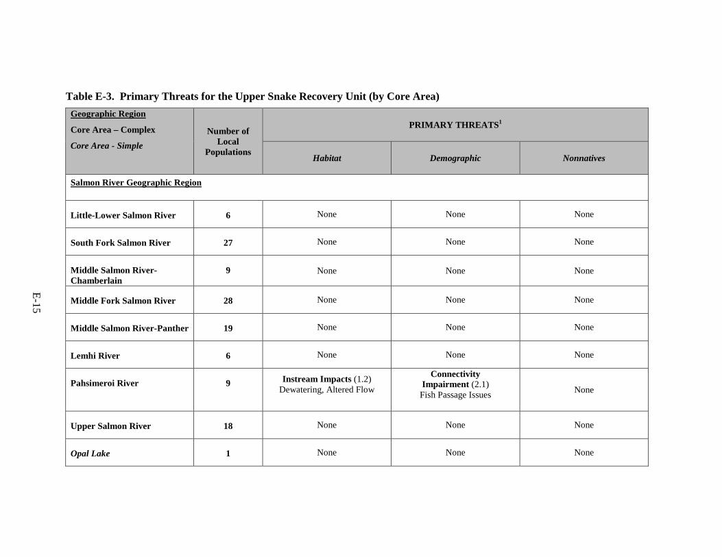
E-15
Table E-3. Primary Threats for the Upper Snake Recovery Unit (by Core Area) Geographic Region
Core Area – Complex
Core Area - Simple Number of
Local Populations
PRIMARY THREATS1
Habitat Demographic Nonnatives
Salmon River Geographic Region
Little-Lower Salmon River 6 None None None
South Fork Salmon River 27 None None None
Middle Salmon River-Chamberlain
9 None None None
Middle Fork Salmon River 28 None None None
Middle Salmon River-Panther 19 None None None
Lemhi River 6 None None None
Pahsimeroi River 9 Instream Impacts (1.2) Dewatering, Altered Flow
Connectivity Impairment (2.1)
Fish Passage Issues None
Upper Salmon River 18 None None None
Opal Lake 1 None None None
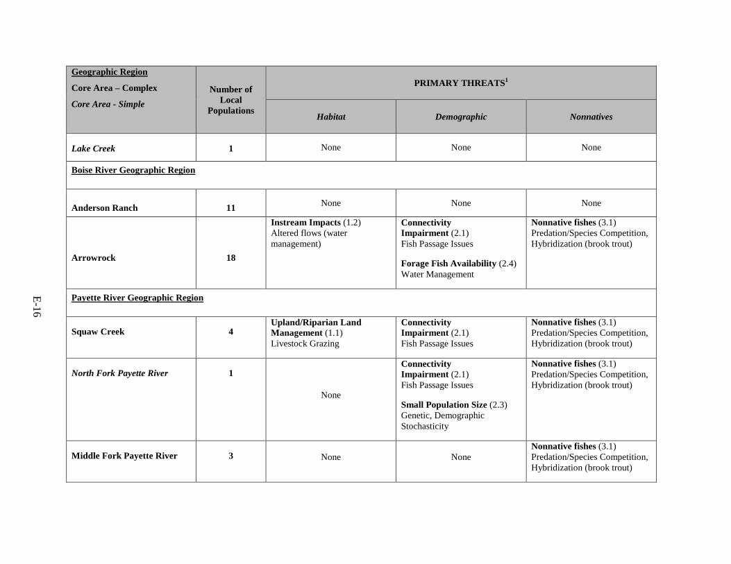
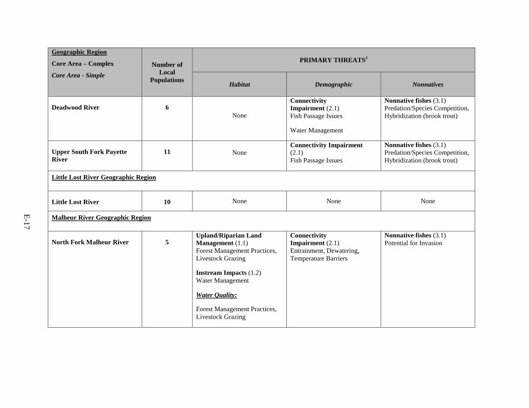
E-16
Geographic Region
Core Area – Complex
Core Area - Simple Number of
Local Populations
PRIMARY THREATS1
Habitat Demographic Nonnatives
Lake Creek 1 None None None
Boise River Geographic Region
Anderson Ranch 11 None None None
Arrowrock 18
Instream Impacts (1.2) Altered flows (water management)
Connectivity Impairment (2.1) Fish Passage Issues
Forage Fish Availability (2.4) Water Management
Nonnative fishes (3.1) Predation/Species Competition, Hybridization (brook trout)
Payette River Geographic Region
Squaw Creek 4 Upland/Riparian Land Management (1.1) Livestock Grazing
Connectivity Impairment (2.1) Fish Passage Issues
Nonnative fishes (3.1) Predation/Species Competition, Hybridization (brook trout)
North Fork Payette River 1
None
Connectivity Impairment (2.1) Fish Passage Issues
Small Population Size (2.3) Genetic, Demographic Stochasticity
Nonnative fishes (3.1) Predation/Species Competition, Hybridization (brook trout)
Middle Fork Payette River 3 None None Nonnative fishes (3.1) Predation/Species Competition, Hybridization (brook trout)
E-17
Geographic Region
Core Area – Complex
Core Area - Simple Number of
Local Populations
PRIMARY THREATS1
Habitat Demographic Nonnatives
Deadwood River 6 None
Connectivity Impairment (2.1) Fish Passage Issues
Water Management
Nonnative fishes (3.1) Predation/Species Competition, Hybridization (brook trout)
Upper South Fork Payette River
11 None Connectivity Impairment (2.1) Fish Passage Issues
Nonnative fishes (3.1) Predation/Species Competition, Hybridization (brook trout)
Little Lost River Geographic Region
Little Lost River 10 None None None
Malheur River Geographic Region
North Fork Malheur River 5 Upland/Riparian Land Management (1.1) Forest Management Practices, Livestock Grazing
Instream Impacts (1.2) Water Management
Water Quality:
Forest Management Practices, Livestock Grazing
Connectivity Impairment (2.1) Entrainment, Dewatering, Temperature Barriers
Nonnative fishes (3.1) Potential for Invasion
E-18
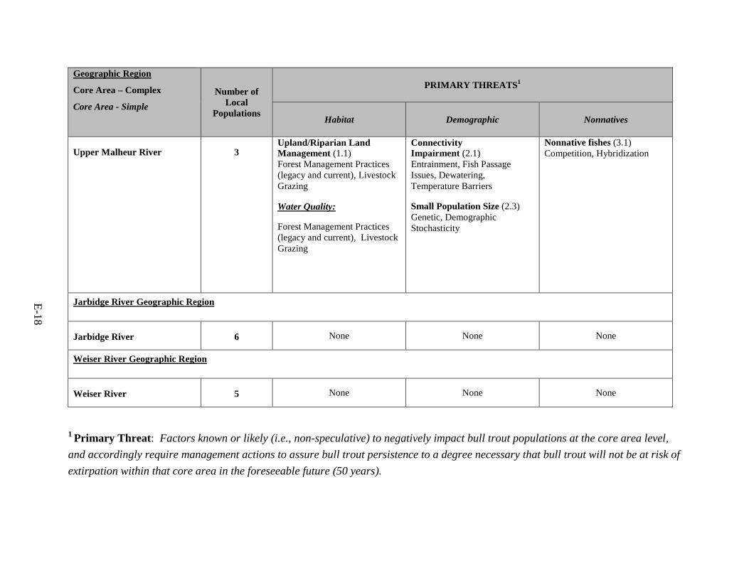
Geographic Region
Core Area – Complex
Core Area - Simple Number of
Local Populations
PRIMARY THREATS1
Habitat Demographic Nonnatives
Upper Malheur River 3 Upland/Riparian Land Management (1.1) Forest Management Practices (legacy and current), Livestock Grazing
Water Quality:
Forest Management Practices (legacy and current), Livestock Grazing
Connectivity Impairment (2.1) Entrainment, Fish Passage Issues, Dewatering, Temperature Barriers
Small Population Size (2.3) Genetic, Demographic Stochasticity
Nonnative fishes (3.1) Competition, Hybridization
Jarbidge River Geographic Region
Jarbidge River 6 None None None
Weiser River Geographic Region
Weiser River 5 None None None
1 Primary Threat: Factors known or likely (i.e., non-speculative) to negatively impact bull trout populations at the core area level, and accordingly require management actions to assure bull trout persistence to a degree necessary that bull trout will not be at risk of extirpation within that core area in the foreseeable future (50 years).
E-19
Ongoing Upper Snake Recovery Unit Conservation Measures (Summary)
Since the listing of bull trout, numerous conservation measures have been and continue to be implemented within the Upper Snake Recovery Unit. These measures are being undertaken by a wide variety of local and regional partnerships, including State fish and game agencies, State and Federal land management and water resource agencies, Tribal governments, power companies, watershed working groups, water users, ranchers, and landowners. In many cases, these bull trout conservation measures incorporate or are closely interrelated with work being done for recovery of salmon and steelhead, which are limited by many of the same threats.
Many restoration projects have been implemented from local funds as well as Bonneville Power Administration funds in predominantly anadromous drainages. Bonneville Power Administration has also funded projects in the Malheur River to support Tribal efforts in recovering bull trout. The Bureau of Reclamation has been implementing various projects within the Malheur and Boise watersheds to better understand the impacts of their operations on bull trout populations.
The numerous localized fish habitat restoration projects in the Salmon River basin that are implemented by Federal, State, and private partners (U.S. Forest Service, Bureau of Land Management, Upper Salmon Basin Watershed Program) should continue and be expanded if possible, to protect and maintain the currently robust population. The Upper Salmon Basin Watershed Program has implemented over 500 projects since 1993 to increase instream flow and improve fish habitat across the Salmon River headwaters, Lemhi River, and Pahsimeroi River watersheds. The program, coordinated by the Idaho Governor’s Office of Species Conservation, works with cooperating private landowners to develop restoration projects and obtain funding from Bonneville Power Administration and other agencies. Projects have included removal of migration barriers to provide fish access to 75 miles (121 kilometers [km]) of stream, screening of 249 irrigation diversions, instream habitat improvement in 494 miles (795 km) of stream, and riparian habitat restoration over 352 miles (566 km) of stream (158 miles [254 km] fenced). Projects have benefited bull trout, salmon, and other salmonid species.
The Forest Service and Bureau of Land Management have updated their Land and Resource Management Plans (LRMPs) and Resource Management Plans to incorporate conservation measures that protect both local populations and habitat used by bull trout. Some Forests did not revise their LRMPs but amended them to include fish and riparian conservation strategies to protect inland native fish and anadromous fish habitat. Numerous passage projects have also increased the amount of habitat as well as improved connectivity throughout the recovery unit. Both these Federal agencies have areas within the Upper Snake with special
E-20
designations such as Wild and Scenic River (Jarbidge River, Malheur River) or Wilderness Designation (Frank Church Wilderness of No Return in the Salmon River and the Jarbidge Wilderness in the Jarbidge River). Both of these designations afford protection for bull trout and its habitat. Another designation that provides protection at a smaller scale are Wilderness Study areas that are dispersed throughout the Upper Snake with concentrations in southeast Oregon and central Idaho.
In southwestern Idaho, the U.S. Forest Service, Idaho Department of Fish and Game, and cooperating private landowners should continue to implement upland and stream habitat restoration actions. Fish passage barriers within the following core areas (e.g., Arrowrock, Squaw Creek, North Fork Payette, and Deadwood core areas) should be evaluated and addressed to improve bull trout population connectivity.
The Idaho Department of Lands (IDL) also implements conservation measures, particularly replacing fish barriers with road crossings that pass fish, on fish bearing streams and at crossings where fish presence is unknown but fish habitat is present. These projects are generally accomplished in conjunction with IDL’s timber sale program where timber sale purchasers are given a development credit for this work.
Research, Monitoring, and Evaluation The Upper Snake Recovery Unit currently lacks trend data in most core areas and there is
a need to collect more information to determine whether populations are stable or increasing. The Idaho Department of Fish and Game and Oregon Department of Fish and Wildlife have collected trend data in only 12 of the 22 core areas in the recovery unit. For core areas that contained trend data, 8 of the 12 indicated either a stable or increasing trend (Table E-2) and decreasing trends were observed in some core areas that we have otherwise identified as likely to be stable without primary threats (Middle Fork Salmon and Middle Salmon-Panther). While many parts of the range are stable or increasing, other areas do not have any information regarding trends. Bull trout trends are unknown within the entire Payette River geographic region, while the Salmon River geographic region has a robust amount of information. Based on discussions with technical partners and the existing trend data it is estimated that 13 of the 22 core areas in the Upper Snake Recovery Unit have either stable or increasing trends since 1995.
E-21
Recovery Measures Narrative
The recovery measures narrative for each core area within the Upper Snake Recovery Unit is structured in a hierarchical step-down narrative under which specific recovery actions are grouped and listed to address identified primary threats. We established three broad primary threat category classifications (Habitat, Demographic, and Non-Natives) which were further subdivided into more specific second-tier threat categories where applicable:
• Habitat – Upland/Riparian Land Management, Instream Impacts, and Water Quality • Demographic – Connectivity Impairment, Fisheries Management, Small Population Size,
and Forage Fish Availability • Nonnatives – Nonnatives
Specific recovery actions are each listed under a third tier of individual threat descriptors which were developed to more specifically characterize these second-tier threat categories for that particular core area. If a second-tier threat category is not applicable to a particular core area, no third-tier threats are listed in the narrative and the second-tier threat is gray-shaded. Core areas and their specific recovery actions have been grouped by the seven major geographic regions shown in Table E-3 above. In addition to third-tier recovery actions that address identified primary threats, we also identified and listed additional conservation recommendations within the recovery measures narrative. These actions are considered beneficial for bull trout conservation and merit implementation, but do not address primary threats and are not considered necessary to meet recovery objectives within a core area.
Salmon River Geographic Region
Little-Lower Salmon River Core Area
1. Actions to Address Habitat Threats
None
2. Actions to Address Demographic Threats
None
3. Actions to Address Nonnative Fishes
None
4. Research, Monitoring, and Evaluation
E-22
4.1 Habitat
4.2 Demographic
Monitoring
4.2.1 Continue ongoing population monitoring efforts within the basin. Maintain current long term datasets assessing abundance and distribution of bull trout. Continue to coordinate surveys among partner agencies.
4.3 Nonnatives
Conservation Recommendations
• Reduce general sediment production. Stabilize roads, road stream crossings, and other known sources of fine sediment delivery. Monitor John Day Creek and Slate Creek.
• Manage for demographic stochasticity by ensuring local populations contain more than 50 to 100 reproductive individuals and manage for environmental stochasticity with populations containing 1,000 to 10,000 individuals, when practicable. Focus on additional survey efforts in smaller watersheds such as John Day Creek, Slate Creek, Lake-Lower Salmon, and Partridge Creek.
• Implement brook trout removal efforts wherever feasible and biologically supported. Consider monitoring populations in John Day Creek and Slate Creek.
• Coordinate bull trout recovery with listed anadromous fish species recovery in the Salmon River Geographic Region.
South Fork Salmon River Core Area
1. Actions to Address Habitat Threats
None
2. Actions to Address Demographic Threats
None
3. Actions to Address Nonnatives
None
4. Research, Monitoring, and Evaluation
4.1 Habitat
E-23
4.2 Demographic
Monitoring
4.2.1 Continue ongoing population monitoring efforts within the basin. Maintain current long term datasets assessing abundance and distribution of bull trout. Continue to coordinate surveys among partner agencies.
4.3 Nonnatives
Conservation Recommendations
• Reduce general sediment production. Stabilize roads, road stream crossings, and other known sources of fine sediment delivery (South Fork Salmon River, Upper East Fork South Fork Salmon River, Lake Creek to Loon Lake, Sugar, Krassel-Indian, Curtis, Johnson [headwaters to mouth], and Cow-Oompaul creeks).
• Clean up mine waste at active, inactive, and orphan sites (Cinnabar and Stibnite Mine) (Meadow Creek and Blowout Creek).
• Implement brook trout removal efforts wherever feasible and biologically supported. • Coordinate bull trout recovery with listed anadromous fish species recovery in the
Salmon River Geographic Region.
Middle Salmon River - Chamberlain Core Area
1. Actions to Address Habitat Threats
None
2. Actions to Address Demographic Threats
None
3. Actions to Address Nonnatives
None
4. Research, Monitoring, and Evaluation
4.1 Habitat
4.2 Demographic
Monitoring

E-24
4.2.1 Continue ongoing population monitoring efforts within the basin. Maintain current long term datasets assessing abundance and distribution of bull trout. Continue to coordinate surveys among partner agencies.
4.3 Nonnatives
Conservation Recommendations
• Reduce general sediment production. Stabilize roads, road stream crossings, and other known sources of fine sediment delivery (Warren, Upper Horse, Wind, Big Mallard, Witsher, Upper Meadow, and Upper Crooked creeks).
• Clean up mine waste at active, inactive, and orphan sites (Warren, Falls, Lake, and Upper Crooked creeks).
• Coordinate bull trout recovery with listed anadromous fish species recovery in the Salmon River Geographic Region.
Middle Fork Salmon River Core Area
1. Actions to Address Habitat Threats
None
2. Actions to Address Demographic Threats
None
3. Actions to Address Nonnative Fishes
None
4. Research, Monitoring, and Evaluation
4.1 Habitat
4.2 Demographic
Monitoring
4.2.1 Continue ongoing population monitoring efforts within the basin. Maintain current long term datasets assessing abundance and distribution of bull trout. Continue to coordinate surveys among partner agencies.
4.3 Nonnatives
Conservation Recommendations
E-25
• Reduce general sediment production. Stabilize roads, road stream crossings, and other known sources of fine sediment delivery (Headwaters to Salmon River, Headwaters to Fall Creek, Bear Valley, Elk Creek, and Lower Camas Creek).
• Implement brook trout removal efforts wherever feasible and biologically supported. • Identify barriers for bull trout and implement tasks to provide passage. • Coordinate bull trout recovery with listed anadromous fish species recovery in the
Salmon River Geographic Region.
Middle Salmon River - Panther Core Area
1. Actions to Address Habitat Threats
None
2. Actions to Address Demographic Threats
None
3. Actions to Address Nonnative Fishes
None
4. Research, Monitoring, and Evaluation
4.1 Habitat
4.2 Demographic
Monitoring
4.2.1 Continue ongoing population monitoring efforts within the basin. Maintain current long term datasets assessing abundance and distribution of bull trout. Continue to coordinate surveys among partner agencies.
4.3 Nonnatives
Conservation Recommendations
• Reduce general sediment production. Stabilize roads, road stream crossings, and other known sources of fine sediment delivery (Big Deer, Hughes, McKim, Musgrove, Moose, Hull, Hughes, Lick, Upper Horse, Squaw, Pine, Opal, Porphyry, Dahlonega Creeks).
• Clean up mine waste at active, inactive, and orphan sites (Blackbird Mine and Bear Track Mine).
E-26
• Identify barriers for bull trout and implement tasks to provide passage. • Implement brook trout removal efforts wherever feasible and biologically supported. • Implement actions necessary to accelerate recovery of riparian vegetation and
streambanks and reduce negative effects from historic and current livestock grazing in identified problem areas (North Fork River, Red, Twelve/Lake watershed, Hat Creek, Deep-Moyer watershed, Napias watershed).
• Coordinate bull trout recovery with listed anadromous fish species recovery in the Salmon River Geographic Region.
Lemhi River Core Area
1. Actions to Address Habitat Threats
None
2. Actions to Address Demographic Threats
None
3. Actions to Address Nonnative Fishes
None
4. Research, Monitoring, and Evaluation
4.1 Habitat
4.2 Demographic
Monitoring
4.2.1 Continue ongoing population monitoring efforts within the basin. Maintain current long term datasets assessing abundance and distribution of bull trout. Continue to coordinate surveys among partner agencies.
4.3 Nonnatives
Conservation Recommendations
• Identify barriers for bull trout and implement tasks to provide passage. • Implement actions necessary to accelerate recovery of riparian vegetation and
streambanks and reduce negative effects from historic and current livestock grazing in identified problem areas (Hayden watershed, Little Eightmile, Canyon, Reservoir, Upper Texas, and Little Timber creeks).
E-27
• Coordinate bull trout recovery with listed anadromous fish species recovery in the Salmon River Geographic Region.
Pahsimeroi River Core Area
1. Actions to Address Habitat Threats
1.1 Upland/Riparian Land Management
1.2 Instream Impacts
1.2.1 Restore streams that are partially or completely dewatered. Improve instream flows.
1.3 Water Quality
2. Actions to Address Demographic Threats
2.1 Connectivity Impairment
2.1.1 Identify barriers for bull trout and implement tasks to provide passage.
2.2 Fisheries Management
2.3 Small Population Size
3. Actions to Address Nonnative Fishes
None
4. Research, Monitoring, and Evaluation
4.1 Habitat
Monitoring
4.1.1 Continue to monitor temperature, water quality, water quantity, and riparian condition to evaluate the effectiveness of habitat restoration actions and to provide the ability to detect trends in these metrics.
4.2 Demographic
Monitoring
4.2.1 Continue ongoing population monitoring efforts within the basin. Maintain current long term datasets assessing abundance and distribution of bull trout. Continue to coordinate surveys among partner agencies.
E-28
4.3 Nonnatives
Conservation Recommendations
• Implement actions necessary to accelerate recovery of riparian vegetation and streambanks and reduce negative effects from historic and current livestock grazing in identified problem areas.
• Coordinate efforts to implement recovery actions that include projects that recover both anadromous fish and bull trout, projects that promote control of brook trout, and projects that identify and remove fish barriers.
Upper Salmon River Core Area
1. Actions to Address Habitat Threats
None
2. Actions to Address Demographic Threats
None
3. Actions to Address Nonnative Fishes
None
4. Research, Monitoring, and Evaluation
4.1 Habitat
4.2 Demographic
Monitoring
4.2.1 Continue ongoing population monitoring efforts within the basin. Maintain current long term datasets assessing abundance and distribution of bull trout. Continue to coordinate surveys among partner agencies.
4.3 Nonnatives
Conservation Recommendations
• Implement brook trout removal efforts wherever feasible and biologically supported. • Implement actions necessary to accelerate recovery of riparian vegetation and
streambanks and reduce negative effects from historic and current livestock grazing
E-29
in identified problem areas (East Fork Salmon, Morgan, Squaw, Challis, Grandiw, Slate, Boulder, and Valley Creeks).
• Coordinate bull trout recovery with listed anadromous fish species recovery in the Salmon River Geographic Region.
Opal Lake Core Area
1. Actions to Address Habitat Threats
None
2. Actions to Address Demographic Threats
None
3. Actions to Address Nonnative Fishes
None
4. Research, Monitoring, and Evaluation
4.1 Habitat
4.2 Demographic
Monitoring
4.2.1 Continue ongoing population monitoring efforts within the basin. Maintain current long term datasets assessing abundance and distribution of bull trout. Continue to coordinate surveys among partner agencies.
4.3 Nonnatives
Conservation Recommendations
• Protect, restore, and maintain suitable habitat conditions for bull trout. Maintain or improve water quality in bull trout core areas.
Lake Creek Core Area
1. Actions to Address Habitat Threats
None
2. Actions to Address Demographic Threats
E-30
None
3. Actions to Address Nonnative Fishes
None
4. Research, Monitoring, and Evaluation
4.1 Habitat
4.2 Demographic
Monitoring
4.2.1 Continue ongoing population monitoring efforts within the basin. Maintain current long term datasets assessing abundance and distribution of bull trout. Continue to coordinate surveys among partner agencies.
4.3 Nonnatives
Conservation Recommendations
• Protect, restore, and maintain suitable habitat conditions for bull trout. Maintain or improve water quality in bull trout core areas.
Boise River Geographic Region
Anderson Ranch Core Area
1. Actions to Address Habitat Threats
None
2. Actions to Address Demographic Threats
None
3. Actions to Address Nonnative Fishes
None
4. Research, Monitoring, and Evaluation
4.1 Habitat
4.2 Demographic
E-31
Monitoring
4.2.1 Continue ongoing population monitoring efforts within the basin. Maintain current long term datasets assessing abundance and distribution of bull trout. Continue to coordinate surveys among partner agencies.
4.3 Nonnatives
Conservation Recommendations
• Reduce general sediment production. Stabilize roads, road stream crossings, and other known sources of fine sediment delivery.
• Implement actions necessary to accelerate recovery of riparian vegetation and streambanks and reduce negative effects from historic and current livestock grazing in identified problem areas.
• Identify barriers for bull trout and implement tasks to provide passage. • Implement brook trout removal efforts wherever feasible and biologically supported. • Implement Terms and Conditions 2 from the 2005 Service Biological Opinion to
minimize the effect of the operation of Anderson Ranch Dam. Effects identified were related to ramping rates and management of flows (USFWS 2005, pg. 259).
Arrowrock Core Area
1. Actions to Address Habitat Threats
None
2. Actions to Address Demographic Threats
2.1 Connectivity Impairment
2.1.1 Identify barriers for bull trout and implement tasks to provide passage.
2.1.2 Operate reservoirs and dams to minimize negative effects on bull trout in reservoirs and habitat downstream. Implement Terms and Conditions 1 from the 2005 Service Biological Opinion to minimize the effect of the operation of Arrowrock Dam. Effects identified were related to extent of drawdown, extent of drafting during summer months, entrainment, and trap and haul program (USFWS 2005, pg. 258).
2.2 Fisheries Management
2.3 Small Population Size
3. Actions to Address Nonnative Fishes
E-32
3.1 Nonnative Fishes
3.1.1 Implement brook trout removal efforts wherever feasible and biologically supported.
4. Research, Monitoring, and Evaluation
4.1 Habitat
4.2 Demographic
Monitoring
4.2.1 Continue ongoing population monitoring efforts within the basin. Maintain current long term datasets assessing abundance and distribution of bull trout. Continue to coordinate surveys among partner agencies.
4.3 Nonnatives
Conservation Recommendations
None
Payette River Geographic Region
Squaw Creek Core Area
1. Actions to Address Habitat Threats
1.1 Upland/Riparian Land Management
1.1.1 Implement actions necessary to accelerate recovery of riparian vegetation and streambanks and reduce negative effects from historic and current livestock grazing in identified problem areas.
1.2 Instream Impacts
1.3 Water Quality
2. Actions to Address Demographic Threats
2.1 Connectivity Impairment
2.1.1 Identify barriers for bull trout and implement tasks to provide passage.
2.2 Fisheries Management
2.3 Small Population Size
E-33
3. Actions to Address Nonnative Fishes
3.1 Nonnative Fishes
3.1.1 Implement brook trout removal efforts wherever feasible and biologically supported.
4. Research, Monitoring, and Evaluation
4.1 Habitat
4.2 Demographic
Monitoring
4.2.1 Continue ongoing population monitoring efforts within the basin. Maintain current long term datasets assessing abundance and distribution of bull trout. Continue to coordinate surveys among partner agencies.
4.3 Nonnatives
Conservation Recommendations
None
North Fork Payette Core Area
1. Actions to Address Habitat Threats
None
2. Actions to Address Demographic Threats
2.1 Connectivity Impairment
2.1.1 Identify barriers for bull trout and implement tasks to provide passage.
2.2 Fisheries Management
2.3 Small Population Size
2.3.1 Manage for demographic stochasticity by ensuring local populations contain more than 50 to 100 reproductive individuals and manage for environmental stochasticity with populations containing 1,000 to 10,000 individuals, when practicable.
E-34
3. Actions to Address Nonnative Fishes
3.1 Nonnative Fishes
3.1.1 Implement brook trout removal efforts wherever feasible and biologically supported.
4. Research, Monitoring, and Evaluation
4.1 Habitat
4.2 Demographic
Monitoring
4.2.1 Continue ongoing population monitoring efforts within the basin. Maintain current long term datasets assessing abundance and distribution of bull trout. Continue to coordinate surveys among partner agencies.
4.3 Nonnatives
Conservation Recommendations
None
Middle Fork Payette Core Area
1. Actions to Address Habitat Threats
None
2. Actions to Address Demographic Threats
None
3. Actions to Address Nonnative Fishes
3.1 Nonnative Fishes
3.1.1 Implement brook trout removal efforts wherever feasible and biologically supported.
E-35
4. Research, Monitoring, and Evaluation
4.1 Habitat
4.2 Demographic
Monitoring
4.2.1 Continue ongoing population monitoring efforts within the basin. Maintain current long term datasets assessing abundance and distribution of bull trout. Continue to coordinate surveys among partner agencies.
4.3 Nonnatives
Conservation Recommendations
None
Deadwood River Core Area
1. Actions to Address Habitat Threats
None
2. Actions to Address Demographic Threats
2.1 Connectivity Impairment
2.1.1 Identify barriers for bull trout and implement tasks to provide passage.
2.1.2 Operate reservoirs and dams to minimize negative effects on bull trout in reservoirs and habitat downstream. Implement Terms and Conditions 3 from the 2005 Service Biological Opinion to minimize the effect of the operation of Deadwood Dam. Effects identified were related to modifying winter streamflows below the dam, modifying extreme low water temperatures below the dam, ramping rates, stream flow management during the spring, and entrainment (USFWS 2005, pg. 258).
2.2 Fisheries Management
2.3 Small Population Size
3. Actions to Address Nonnative Fishes
3.1 Nonnative Fishes
E-36
3.1.1 Implement brook trout removal efforts wherever feasible and biologically supported.
4. Research, Monitoring, and Evaluation
4.1 Habitat
4.2 Demographic
Monitoring
4.2.1 Continue ongoing population monitoring efforts within the basin. Maintain current long term datasets assessing abundance and distribution of bull trout. Continue to coordinate surveys among partner agencies.
4.3 Nonnatives
Conservation Recommendations
None
Upper South Fork Payette River Core Area
1. Actions to Address Habitat Threats
None
2. Actions to Address Demographic Threats
2.1 Connectivity Impairment
2.1.1 Identify barriers for bull trout and implement tasks to provide passage.
2.2 Fisheries Management
2.3 Small Population Size
3. Actions to Address Nonnative Fishes
3.1 Nonnative Fishes
3.1.1 Implement brook trout removal efforts wherever feasible and biologically supported.
4. Research, Monitoring, and Evaluation
4.1 Habitat

E-37
4.2 Demographic
Monitoring
4.2.1 Continue ongoing population monitoring efforts within the basin. Maintain current long term datasets assessing abundance and distribution of bull trout. Continue to coordinate surveys among partner agencies.
4.3 Nonnatives
Conservation Recommendations
None
Little Lost River Geographic Region
Little Lost River Core Area
1. Actions to Address Habitat Threats
None
2. Actions to Address Demographic Threats
None
3. Actions to Address Nonnative Fishes
None
4. Research, Monitoring, and Evaluation
4.1 Habitat
4.2 Demographic
Monitoring
4.2.1 Continue ongoing population monitoring efforts within the basin. Maintain current long term datasets assessing abundance and distribution of bull trout. Continue to coordinate surveys among partner agencies.
4.3 Nonnatives
Conservation Recommendations
• Identify barriers for bull trout and implement tasks to provide passage.
E-38
• Implement brook trout removal efforts wherever feasible and biologically supported. • Implement actions necessary to accelerate recovery of riparian vegetation and
streambanks and reduce negative effects from historic and current livestock grazing in identified problem areas.
Malheur River Geographic Region
North Fork Malheur Core Area
1. Actions to Address Habitat Threats
1.1. Upland/Riparian Land Management
Forest Management Practices
1.1.1 Restore canopy and riparian cover and native vegetation in all bull trout spawning, rearing, and migration areas. Horse Creek, Swamp Creek, Sheep Creek, Flat Creek, Elk Creek, Little Crane Creek, Crane Creek, and the North Fork Malheur River have suppressed woody vegetation and loss of effective shade. Emphasis should also be put on the Little Malheur River as bull trout have been recently captured there and it has the potential to provide spawning and rearing habitat. This component is vital to restoring not only shade but also natural instream processes, hydrologic function, and thermal regimes.
1.1.2 Implement stream restoration projects in degraded stream reaches. Review habitat information to identify and prioritize opportunities for stream restoration in Horse Creek, Swamp Creek, Sheep Creek, Flat Creek, Elk Creek, Little Crane Creek, Crane Creek, the North Fork Malheur River, and Little Malheur River. Design and implement projects based on findings.
1.1.3 Provide a reliable source of large hardwood beaver forage. Beaver have disappeared from much of their historical range. Beavers initiate and maintain critical watershed processes important to water retention, sediment sequestration, cold water storage, and flood plain connectivity. The re-establishment of these processes in the riverscape is critical to the recovery of bull trout and their habitat. The current lack of hardwoods in riparian habitats and the necessary structure to support beaver dam construction are one of the factors limiting the recolonization of the Upper Malheur River by beaver. Grazing pressure on riparian communities is detrimental to re-stablishing these critical riparian
E-39
hardwoods. Implement activities to encourage riparian shrub and hardwood communities to re-establish in an effort to encourage beaver to naturally recolonize and restore the riverscape. Consider providing large support material to jump start beaver dam construction.
1.1.4 Evaluate and implement actions to encourage beaver recolonization. To assist in re-establishing functional riparian communities, Federal, Tribal and State resource managers should identify and implement measures to increase beaver abundance where feasible and biologically supportable. Reduction in beaver trapping pressures, increases in active releases, and utilization of beaver control structures should be considered where effective and appropriate.
Livestock Grazing
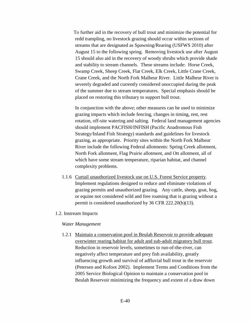
1.1.5 Reduce grazing impacts. While recognizing that no livestock grazing would likely achieve recovery of habitat and populations more rapidly, the following measures would allow for livestock grazing occurring while habitat and populations recover at less than a near-natural rate of recovery. Livestock grazing within riparian areas proximate to bull trout critical habitat should be limited to light utilization and minimal bank disturbance. Based on current and best available science, threshold indicators should be monitored utilizing the Multiple Indicator Monitoring Method (Burton et al. 2011). Threshold indicators when measured for early to mid-season should not exceed:
Indicator Foraging / Migration /
Overwintering
Spawning / Rearing
Comments
Bank Alteration
Less than 20% Less than 15%
• Monitor within a week of the cows coming off the pasture.
• Burton et al. 2011
• Bengeyfield 2006
Stubble Height
6” (Early season )
8” (Late season )
8” (Early season )
10” (Late season )
• Goss 2013 (MS Thesis)
• Clary and Webster (1989)
Browse Light (21 to 40%) Slight (0 to 20%) • Burton et al. 2011
E-40
To further aid in the recovery of bull trout and minimize the potential for redd trampling, no livestock grazing should occur within sections of streams that are designated as Spawning/Rearing (USFWS 2010) after August 15 to the following spring. Removing livestock use after August 15 should also aid in the recovery of woody shrubs which provide shade and stability to stream channels. These streams include: Horse Creek, Swamp Creek, Sheep Creek, Flat Creek, Elk Creek, Little Crane Creek, Crane Creek, and the North Fork Malheur River. Little Malheur River is severely degraded and currently considered unoccupied during the peak of the summer due to stream temperatures. Special emphasis should be placed on restoring this tributary to support bull trout.
In conjunction with the above; other measures can be used to minimize grazing impacts which include fencing, changes in timing, rest, rest rotation, off-site watering and salting. Federal land management agencies should implement PACFISH/INFISH (Pacific Anadromous Fish Strategy/Inland Fish Strategy) standards and guidelines for livestock grazing, as appropriate. Priority sites within the North Fork Malheur River include the following Federal allotments: Spring Creek allotment, North Fork allotment, Flag Prairie allotment, and Ott allotment, all of which have some stream temperature, riparian habitat, and channel complexity problems.
1.1.6 Curtail unauthorized livestock use on U.S. Forest Service property. Implement regulations designed to reduce and eliminate violations of grazing permits and unauthorized grazing. Any cattle, sheep, goat, hog, or equine not considered wild and free roaming that is grazing without a permit is considered unauthorized by 36 CFR 222.20(b)(13).
1.2. Instream Impacts
Water Management
1.2.1 Maintain a conservation pool in Beulah Reservoir to provide adequate overwinter rearing habitat for adult and sub-adult migratory bull trout. Reduction in reservoir levels, sometimes to run-of-the-river, can negatively affect temperature and prey fish availability, greatly influencing growth and survival of adfluvial bull trout in the reservoir (Petersen and Kofoot 2002). Implement Terms and Conditions from the 2005 Service Biological Opinion to maintain a conservation pool in Beulah Reservoir minimizing the frequency and extent of a draw down
E-41
during years in which snow pack and/or stream flow is insufficient to exceed irrigation needs.
1.3. Water Quality
Forest Management Practices and Livestock Grazing
1.3.1 Maintain or improve effective shade to achieve water quality objectives as outlined in the TMDL (Total Maximum Daily Load) recommending no reduction of effective shade. Management activities should allow for recovery of effective shade based on site potential vegetation. The Oregon Department of Environmental Quality completed the Malheur Basin TMDL and Water Quality Management Plan in September 2010. The Malheur National Forest is slated to complete a water quality recovery plan in 2015. Follow recommendations and measures presented in these plans. Implement action 1.1.1 to help improve effective shade.
Agriculture Practices
1.3.2 Cool irrigation returns and run-off. Diversions or runoff warmer than the receiving water should be cooled when possible before allowing it to enter the receiving system (e.g., subterranean pipes).
2. Actions to Address Demographic Threats
2.1. Connectivity Impairment
Entrainment & Fish Passage Issues
2.1.1 Install appropriate fish screens and passage structures around diversions and/or remove related migration barriers. Complete an inventory of unscreened irrigation diversions within the basin. Known high priorities for screening include diversions on the North Fork Malheur River. Diversions on Forest Service property have either been screened or closed; if re-opened install appropriate screens to prevent entrainment of bull trout.
2.1.2 Reduce occurrence of spill at Agency Valley Dam to minimize entrainment of bull trout below the dam and provide upstream passage when entrainment occurs. Bull trout are entrained over the spillway of Agency Valley Dam when spill occurs. Once entrained, there is no existing facility for fish to return upstream to the reservoir. Due to elevated summer stream temperatures and low flows caused by irrigation withdrawal habitat conditions downstream of the dam are not suitable for
E-42
bull trout survival. Implement the Terms and Conditions of the 2005 Service Biological Opinion to continue all existing efforts to limit the use of the spillway, minimize duration and quantity of spill, and trap and return bull trout that are entrained when the spillway is used back to Beulah Reservoir or the North Fork Malheur River above the dam.
2.1.3 Identify and remove barriers to juvenile and adult passage. Log weirs, culverts, legacy structures and other aquatic organism passage barriers impede juvenile and adult passage and prevent movement between spawning, rearing and overwinter habitats. Culverts for the National Forest road NF-13 where it crosses Swamp and Sheep creeks are a priority.
Dewatering
2.1.4 Improve and secure instream flows. Restore connectivity and opportunities for migration by securing instream flows and/or water rights. Improve irrigation efficiency. In addition, implement stream restoration actions identified under Recovery Action 1. Benefits of stream restoration will include raising the water table and restoring natural instream flow, providing more water during summer and late fall.
Temperature Barriers
2.1.5 Eliminate thermal barriers by maintaining or improving riparian vegetation communities, providing shade to streams, and increasing instream flow. Current bull trout distribution and movement is impeded by thermal barriers between spawning and rearing habitats. During the summer months, water temperature in the North Fork Malheur River between Beulah Reservoir and Crane Creek is considered a barrier to movement, and additional thermal barriers upstream of Crane Creek may occur in some years. Implement actions designed to cool warm water temperatures, increase flows, and improve hydrologic function as detailed under Recovery Action 1.
2.2. Fisheries Management
2.3. Small Population Size
2.4. Forage Fish Availability
3. Actions to Address Nonnative Fishes
3.1 Nonnative Fishes
E-43
Potential for Invasion
3.1.1 Survey and monitor the North Fork watershed for the presence of brook trout. Currently, brook trout are absent in the North Fork Malheur River. The illegal introduction and subsequent invasion of brook trout into the North Fork Malheur River would negatively impact bull trout populations through competition and hybridization and could quickly become one of the most significant threats to bull trout in the basin. Periodically and regularly survey the North Fork Malheur River watershed, within and outside the distribution of bull trout, for the presence of brook trout. Consider using e-DNA methodology as a low cost means to monitor the basin for brook trout occupancy.
3.1.2 Prioritize the removal of brook trout in adjacent basins. The presence of brook trout in high densities in the Upper Malheur River basin poses a direct threat to the bull trout in the North Fork Malheur core area. The risk of illegal inter-basin transfer is potentially very high. The removal or control of brook trout in the Upper Malheur River basin will decrease this risk considerably.
3.1.3 Implement recovery actions that will ensure the expression of a migratory life history. Impacts of brook trout to bull trout populations appear to be most significant for populations of primarily resident fish. Bull trout populations containing large migratory individuals manage to maintain despite the presence of brook trout. In addition, large fish are more fecund, have great productivity, and can out-compete smaller brook trout for food and space resources. Recovery actions specific to fostering a migratory life history include 1.2.1 and 2.1.2 (to ensure suitable overwintering habitat in Beulah Reservoir), and 2.1.1 through 2.1.3 (to maintain passable migratory corridors).
3.1.4 Implement brook trout removal efforts when brook trout are detected in the North Fork Malheur core area. Immediately conduct brook trout eradication efforts, when and if detected, in the North Fork Malheur Basin to prevent dispersal and colonization of the species.
3.1.5 Develop and implement an educational effort to address problems and consequences of unauthorized fish introductions. Target areas where inter-basin transfer of brook trout from adjacent systems would be most likely.
4. Monitoring and Evaluation
E-44
4.1 Habitat
Monitoring
4.1.1 Continue to monitor temperature, water quality, water quantity, and riparian condition to evaluate the effectiveness of habitat restoration actions and to provide the ability to detect trends in these metrics.
4.2 Demographic
Research
4.2.1 Further define bull trout distribution and habitat use in the core area. Research is needed to determine the extent to which bull trout express a fluvial, and potentially adfluvial, life history in the North Fork Malheur River.
Monitoring
4.2.2 Continue maintenance and operation of fish screens on all diversions. Constant monitoring and maintenance is necessary to keep fish screens operating properly.
4.2.3 Continue ongoing population monitoring efforts within the basin. Maintain current long term redd count datasets assessing abundance and distribution of spawning migratory bull trout. If necessary, bolster the monitoring program with new protocols and methodologies consistent with other programs statewide. Continue to coordinate surveys among partner agencies.
4.3 Nonnatives
4.3.1 Implement bass and crappie monitoring efforts in Beulah Reservoir. Current data demonstrates multiple year classes of both nonnative species. Implementation of a conservation pool will likely allow both species to expand. Predation by bass could occur on bull trout and competition for prey would occur by both species.
Conservation Recommendations
• Promote interagency collaboration and coordination on bull trout recovery actions by supporting existing bull trout working groups or the formation of new bull trout working groups where they do not exist. While working groups may be facilitated by any interested stakeholder, most often they are organized and facilitated by the Service, a State agency, U.S. Forest Service, or a Tribal entity. Although the Service
E-45
has no guidelines for format or process, existing working groups are largely informal, are organized at various scales (e.g., core area, river basin, geographic region, or recovery unit) and generally meet at least annually.
• Identify and address sediment sources in North Fork Malheur Basin affecting bull trout. Identify road-related sediment problem areas in the North Fork Malheur River core area prioritizing spawning and rearing streams. Examine the ways roads capture and channel runoff, and changes in surface runoff associated with soil compaction. Stabilize roads, crossings, railroad grades, and other sources of sediment delivery; remove and vegetatively restore unneeded roads and railroad grades.
• Increase information outreach to anglers. Provide information on bull trout identification, special regulations, methods to reduce hooking mortality of bull trout caught incidentally, and the value of bull trout and their habitat.
• Investigate and implement actions to restore historic prey base by reintroducing anadromous species from appropriate stocks. Anadromous species such as steelhead and spring Chinook salmon were historically present in the North Fork Malheur River. Feasibility of restoration of spawning populations of these species to increase prey base and provide marine derived nutrients should be evaluated and implemented where feasible and biologically supportable.
Upper Malheur Core Area
1. Actions to Address Habitat Threats
1.1. Upland/Riparian Land Management
Forest Management Practices
1.1.1 Restore canopy and riparian cover, and native vegetation in all bull trout spawning, rearing, and migration areas. Crooked Creek, McCoy Creek, Lake Creek, Coral Basin Creek, Bosonberg Creek, Big Creek, Summit Creek, and the Malheur River downstream of Logan Valley have suppressed woody vegetation and loss of effective shade. This component is vital to restoring not only shade but also natural instream processes, hydrologic function, and thermal regimes.
1.1.2 Implement stream restoration projects in degraded stream reaches. Review habitat information to identify and prioritize opportunities for stream restoration, including increasing pool and gravel area, in Crooked Creek, McCoy Creek, Lake Creek, Coral Basin Creek, Bosonberg Creek,
E-46
Big Creek, Summit Creek, and the Malheur River downstream of Logan Valley. Design and implement projects based on findings.
1.1.3 Provide a reliable source of large hardwood beaver forage. Beaver have disappeared from much of their historical range. Beavers initiate and maintain critical watershed processes important to water retention, sediment sequestration, cold water storage, and flood plain connectivity. The re-establishment of these processes in the riverscape is critical to the recovery of bull trout and their habitat. The current lack of hardwoods in riparian habitats and the necessary structure to support beaver dam construction are one of the factors limiting the recolonization of the Upper Malheur River by beaver. Grazing pressure on riparian communities is detrimental to re-stablishing these critical riparian hardwoods. Implement activities to encourage riparian shrub and hardwood communities to re-establish in an effort to encourage beaver to naturally recolonize and restore the riverscape. Consider providing large support material to jump start beaver dam construction.
1.1.4 Evaluate and implement actions to encourage beaver recolonization. To assist in re-establishing functional riparian communities, Federal, Tribal and State resource managers should identify and implement measures to increase beaver abundance where feasible and biologically supportable. Reduction in beaver trapping pressures, increases in active releases, and utilization of beaver control structures should be considered where effective and appropriate.
Livestock Grazing
1.1.5 Reduce grazing impacts. While recognizing no livestock grazing would likely achieve recovery of habitat and populations more rapidly, the following measures would allow livestock grazing to occur while habitat and populations recover at less than a near-natural rate of recovery. Livestock grazing within riparian areas proximate to bull trout critical habitat should be limited to light utilization and minimal bank disturbance. Based on current and best available science, threshold indicators should be monitored utilizing the Multiple Indicator Monitoring Method (Burton et al. 2011). Threshold indicators, when measured in early to mid-season, should not exceed:
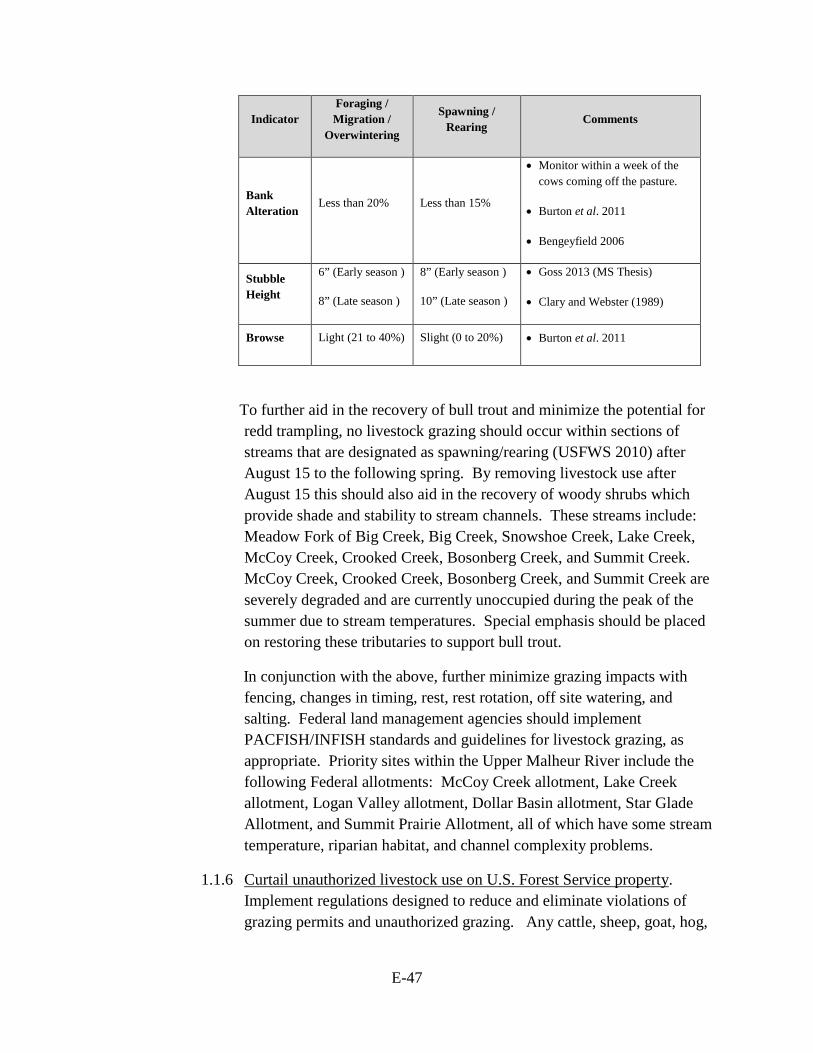
E-47
Indicator Foraging / Migration /
Overwintering
Spawning / Rearing
Comments
Bank Alteration
Less than 20% Less than 15%
• Monitor within a week of the cows coming off the pasture.
• Burton et al. 2011
• Bengeyfield 2006
Stubble Height
6” (Early season )
8” (Late season )
8” (Early season )
10” (Late season )
• Goss 2013 (MS Thesis)
• Clary and Webster (1989)
Browse Light (21 to 40%) Slight (0 to 20%) • Burton et al. 2011
To further aid in the recovery of bull trout and minimize the potential for redd trampling, no livestock grazing should occur within sections of streams that are designated as spawning/rearing (USFWS 2010) after August 15 to the following spring. By removing livestock use after August 15 this should also aid in the recovery of woody shrubs which provide shade and stability to stream channels. These streams include: Meadow Fork of Big Creek, Big Creek, Snowshoe Creek, Lake Creek, McCoy Creek, Crooked Creek, Bosonberg Creek, and Summit Creek. McCoy Creek, Crooked Creek, Bosonberg Creek, and Summit Creek are severely degraded and are currently unoccupied during the peak of the summer due to stream temperatures. Special emphasis should be placed on restoring these tributaries to support bull trout.
In conjunction with the above, further minimize grazing impacts with fencing, changes in timing, rest, rest rotation, off site watering, and salting. Federal land management agencies should implement PACFISH/INFISH standards and guidelines for livestock grazing, as appropriate. Priority sites within the Upper Malheur River include the following Federal allotments: McCoy Creek allotment, Lake Creek allotment, Logan Valley allotment, Dollar Basin allotment, Star Glade Allotment, and Summit Prairie Allotment, all of which have some stream temperature, riparian habitat, and channel complexity problems.
1.1.6 Curtail unauthorized livestock use on U.S. Forest Service property. Implement regulations designed to reduce and eliminate violations of grazing permits and unauthorized grazing. Any cattle, sheep, goat, hog,
E-48
or equine not considered wild and free roaming that is grazing without a permit is considered unauthorized by 36 CFR 222.20(b)(13).
1.2. Instream Impacts
1.3. Water Quality
Forest Management Practices and Livestock Grazing
1.3.1 Maintain or improve effective shade to achieve water quality objectives as outlined in the TMDL recommending no reduction of effective shade. Management activities should allow for recovery of effective shade based on site potential vegetation. The Malheur Basin TMDL and Water Quality Management Plan were completed September 2010. The Malheur National Forest is slated to complete a water quality recovery plan in 2015. Follow recommendations presented in these plans.
Agriculture Practices
1.3.2 Cool irrigation returns and run-off. Diversions or runoff warmer than the receiving water should be cooled when possible before allowing to it to enter the receiving system (e.g., subterranean pipes).
2. Actions to Address Demographic Threats
2.1. Connectivity Impairment
Entrainment & Fish Passage Issues
2.1.1 Install appropriate fish screens and passage structures around diversions and/or remove related migration barriers. High priorities for screening include diversions on Lake Creek and Bosonberg Creek and the Drewsey Diversion. An inventory on Upper Malheur River is incomplete.
2.1.2 Provide passage at road-related barriers and culverts. The U.S. Forest Service is currently developing watershed action plans for the core area. These action plans include an analysis of passage issues as they relate to bull trout. Implement measures identified and prioritized in the U.S. Forest Service watershed action plans to provide passage at road related barriers including those on Corral Basin and Summit creeks.
2.1.3 Identify and remove barriers to juvenile and adult passage. Log weirs, culverts, legacy structures and other barriers impede juvenile and adult passage and prevent movement between spawning, rearing and overwinter habitats.

E-49
Dewatering
2.1.4 Improve and secure instream flows. Restore connectivity and opportunities for migration by securing instream flows and/or water rights. Improve irrigation efficiency. Lower Lake Creek in particular becomes dewatered due to management actions taken on upstream private property. In addition, implement channel restoration actions identified under Recovery Action 1. Benefits of stream channel restoration will include raising the water table and restoring natural instream flow, providing more flow during summer and late fall.
Temperature Barriers
2.1.5 Eliminate thermal barriers by maintaining or improving riparian vegetation communities, providing shade to streams, and increasing water quantity. Current juvenile and adult bull trout distribution and movement is impeded by thermal barriers between spawning, rearing, and overwintering habitats. Seasonal thermal barriers exist at the mouths of Lake, McCoy, and Summit creeks as well as the upper mainstem river. Implement actions designed to cool warm water temperatures, increase flows, and improve hydrologic function as detailed under Recovery Action 1. Partnerships with private landowners may be necessary to eliminate thermal barriers, particularly on Lake Creek and McCoy Creek.
2.2. Fisheries Management
2.3. Small Population Size
At this time, we expect the implementation of the recovery actions identified herein will be sufficient to increase population size and maintain gene flow among populations and will ameliorate any deleterious effects of genetic and demographic stochasticity in addition to recovering the migratory life history type. Additional measures, such as population augmentation or reintroduction within historical distribution, should be considered in the event a demographic response to these actions is not observed.
2.3.1 Investigate merits of developing a genetic management plan for the Upper Malheur core area given the extremely low population size and high abundance of brook trout.
2.4. Forage Fish Availability

E-50
3. Actions to Address Nonnative Fishes
3.1 Nonnative Fish
Competition and Hybridization
3.1.1 Develop and implement a comprehensive watershed-wide brook trout eradication and control strategy. In order to address the threat of brook trout long-term and over a biologically-supportable geographic scale, a watershed level plan must be developed and implemented so that eradication treatments can be evaluated in the context of overall long-term suppression, and to actively or passively encourage bull trout recolonization into treated areas. The strategy should prioritize stream reaches where success will be most likely and where threats to existing bull trout populations (i.e., hybridization rates, competition, etc.) are most significant. Removal efforts should employ the use of tested and proven barriers to prevent re-invasion from adjacent reaches occupied by brook trout. Continue to work collaboratively with partner agencies to develop and implement this control and eradication strategy.
3.1.2 Implement actions that will ensure the expression of a migratory life history. Impacts of brook trout to bull trout populations appear to be most significant for populations of primarily resident fish. Bull trout populations containing large migratory individuals manage to maintain despite the presence of brook trout. In addition, large fish are more fecund, have great productivity, and can out-compete smaller brook trout for food and space resources. Actions specific to fostering a migratory life history include those under Recovery Action 1 to ensure suitable overwintering habitat in the Malheur River, and those under Recovery Action 2.1 to maintain passable migratory corridors.
3.1.3 Develop and implement education and outreach efforts to address problems and consequences of unauthorized fish introductions. Target areas where intra-basin transfer of brook trout from adjacent systems would be most likely.
E-51
4. Research, Monitoring, and Evaluation
4.1 Habitat
Monitoring
4.1.1 Continue to monitor temperature, water quality, water quantity, and riparian condition to evaluate the effectiveness of habitat restoration actions and to provide the ability to detect trends in these metrics.
4.2 Demographic
Research
4.2.1 Further define bull trout distribution and habitat use in the core area. Research is needed to determine the extent to which bull trout express a fluvial, and potentially adfluvial, life history in the Upper Malheur River.
Monitoring
4.2.2 Continue ongoing population monitoring efforts within the basin. Maintain current long-term redd count datasets assessing abundance and distribution of spawning migratory bull trout. If necessary bolster the monitoring program with new protocols and methodologies consistent with other programs statewide. Continue to coordinate surveys among partner agencies.
4.2.3 Continue maintenance and operation of fish screens on all diversions. To prevent entrainment, consistent monitoring and maintenance is necessary to keep fish screens operating properly.
4.3 Nonnatives
Conservation Recommendations
• Promote interagency collaboration and coordination on bull trout recovery actions by supporting existing bull trout working groups or the formation of new bull trout working groups where they do not exist. While working groups may be facilitated by any interested stakeholder, most often they are organized and facilitated by the Service, a State agency, U.S. Forest Service, or a Tribal entity. Although the Service has no guidelines for format or process, existing working groups are largely informal, are organized at various scales (e.g., core area, river basin, geographic region, or recovery unit), and generally meet at least annually.
E-52
• Provide long-term habitat protection through purchase of private property from willing sellers. Potential candidates include the remaining privately-held parcels in the Upper Malheur River corridor including tracts on lower Big, Summit, Lake, and Bosonberg Creeks.
• Identify and address sediment sources in Upper Malheur River basin affecting bull trout. Identify road-related sediment problem areas in the Upper Malheur River core area prioritizing spawning and rearing areas. Examine the ways roads capture and channel runoff, and changes in surface runoff associated with soil compaction. Stabilize roads, crossings, railroad grades, and other sources of sediment delivery; remove and vegetatively restore unneeded roads and railroad grades.
• Increase information outreach to anglers. Provide information on bull trout identification, special regulations, methods to reduce hooking mortality of bull trout caught incidentally, and the value of bull trout and their habitat. Education and outreach designed to assist anglers in identifying and differentiating captured brook trout from bull trout is needed to reduce unintended take of bull trout. Signage should be increased in Big Creek, Lake Creek, and access points along the main stem Upper Malheur River alerting anglers of bull trout presence in the streams.
• Investigate and implement actions to restore historic prey base by reintroducing anadromous species from appropriate stocks. Anadromous species such as steelhead and spring Chinook salmon were historically present in the Upper Malheur River. Feasibility of restoration of spawning populations of these species to increase prey base and provide marine derived nutrients should be evaluated and implemented where feasible and biologically supportable.
Jarbidge River Geographic Region
Jarbidge River Core Area
1. Actions to Address Habitat Threats
None
2. Actions to Address Demographic Threats
None
3. Actions to Address Nonnative Fishes
None
E-53
4. Research, Monitoring, and Evaluation
4.1 Habitat
4.2 Demographic
Monitoring
4.2.1 Continue ongoing population monitoring efforts within the basin. Maintain current long term datasets assessing abundance and distribution of bull trout. Continue to coordinate surveys among partner agencies.
4.3 Nonnatives
Conservation Recommendations
• Ensure that sedimentation from road maintenance is minimized from entering bull trout critical habitat. Develop a road maintenance agreement with the Forest Service, Three Creeks, and local counties.
• Consider developing and implementing a vegetation management plan within the West Fork Jarbidge River.
• Consider working with Trout Unlimited to address legacy mine issues in the West Fork Jarbidge River.
• Consider development of a habitat conservation plan with private landowners in Dave Creek.
Weiser River Geographic Region
Weiser River Core Area
1. Actions to Address Habitat Threats
None
2. Actions to Address Demographic Threats
None
3. Actions to Address Nonnative Fishes
None
4. Research, Monitoring, and Evaluation
4.1 Habitat
E-54
4.2 Demographic
Monitoring
4.2.1 Continue ongoing population monitoring efforts within the basin. Maintain current long term datasets assessing abundance and distribution of bull trout. Continue to coordinate surveys among partner agencies.
4.3 Nonnatives
Conservation Recommendations
• Protect, restore, and maintain suitable habitat conditions for bull trout. Maintain or improve water quality in bull trout core areas.
• Implement brook trout removal efforts wherever feasible and biologically supported.
E-55
Implementation Schedule for the Upper Snake Recovery Unit
The Implementation Schedule that follows describes recovery action priorities, action numbers, action descriptions, duration of actions, potential or participating responsible parties, total cost estimate and estimates for the next 5 years, if available, and comments. These recovery actions, when accomplished in conjunction with implementation of recovery actions in the other bull trout recovery units, will lead to recovery of bull trout in the coterminous United States as discussed in the bull trout recovery plan (USFWS 2015).
Parties with authority, responsibility, or expressed interest to implement a specific
recovery action are identified in the Implementation Schedule. Listing a responsible party does not imply that prior approval has been given or require that party to participate or expend any funds. However, willing participants will benefit by demonstrating that their budget submission or funding request is for a recovery action identified in an approved recovery plan, and is therefore part of a coordinated effort to recover bull trout. In addition, section 7(a)(1) of the Endangered Species Act (Act) directs all Federal agencies to use their authorities to further the purposes of the Act by implementing programs for the conservation of threatened or endangered species.
Interrelated Costs of Recovery Actions
The costs of recovery within the Upper Snake Recovery Unit vary among core areas. Cost estimates identified can be a reflection of specific recovery costs solely for the purpose of bull trout recovery, shared costs with other species, or costs for actions that benefit bull trout but are implemented due to other legal or management obligations already in place. Recovery costs are directly related to the implementation of recovery actions identified to address primary threats to bull trout or to monitor bull trout populations within each core area. These costs are the Service’s best estimate at the current time of those required to implement these actions.
Core areas and FMO (foraging, migration, overwintering) habitat that contain both anadromous fish and bull trout reflect shared costs among all these species. Areas within the Salmon basin are the only core areas in the Upper Snake that contain both bull trout and anadromous species. The costs identified within those areas are costs that are shared with, or even driven by, salmon and steelhead recovery efforts. Many actions that are implemented for the recovery of anadromous fish (e.g. fish screening, fish passage, connectivity, stream flow improvement, etc.) will also provide benefits to overlapping bull trout populations.
The recovery costs identified within the remaining core areas or FMO habitat that only contain bull trout is directly attributed to bull trout recovery since no other listed fish species
E-56
occur within the remaining basins (Malheur, Jarbidge, Weiser, Payette, Boise, and Little Lost). But in all areas, including those within the Salmon basin, there may be recovery actions identified that need to be implemented due to other legal and management reasons beyond bull trout recovery implementation. For example, these may include implementation of recovery actions related to obligations under existing section 7 consultations, Superfund restoration actions, Federal Energy Regulatory Commission dam relicensing, National Forest Management Act, Clean Water Act, State regulations, and/or conservation of other aquatic species, etc.).
The implementation schedule includes the following components:
Threat Factor: Listing factor or threat category addressed by the recovery action.
A. The Present or Threatened Destruction, Modification or Curtailment of Bull Trout Habitat or Range;
B. Overutilization for Commercial, Recreational, Scientific, or Educational Purposes;
C. Disease or Predation; D. The Inadequacy of Existing Regulatory Mechanisms; or E. Other Natural or Manmade Factors Affecting Its Continued Existence.
Recovery Action Priority:
Priority 1: An action that must be taken to prevent extinction or prevent the species from declining irreversibly in the foreseeable future.
Priority 2: An action that must be taken to prevent a significant decline in
species population or habitat quality. Priority 3: All other actions necessary to meet the recovery objectives.
For reference we also list additional conservation recommendations (marked Cons Rec). These actions are potentially beneficial for bull trout conservation and merit implementation, but they are not considered necessary to meet recovery objectives within a core area and so are not classified as Priority 1, 2, or 3. Conservation recommendations are not included in recovery cost estimates.
We evaluate recovery action priorities relative to the core area(s) where
the action is targeted. Recovery action priorities may reflect both the severity of the threat and the expected effectiveness of the action in addressing it.
E-57
Research, monitoring and evaluation (RM&E) actions necessary for
recovery are those deemed critical for developing information for planning, implementing, monitoring, and evaluating effectiveness of recovery actions addressing management of primary threats. Depending on the level of importance of this information, these RM&E actions may be classified as Priority 1, 2, or 3. Other RM&E actions, while possibly informative and potentially contributing to recovery, may not be deemed necessary and will thus be classified as conservation recommendations. Recovery Action Number and Description: Recovery actions as numbered in the recovery outline. Refer to the Narrative for action descriptions. Recovery Action Duration: Indicates the number of years estimated to complete the action, or other codes defined as follows:
Continual (C) – An action that will be implemented on a routine basis once begun. Ongoing (O) – An action that is currently being implemented and will continue
until no longer necessary. To be Determined (TBD) – The action duration is not known at this time or
implementation of the action is dependent on the outcome of other recovery actions.
Responsible or Participating Party: The following organizations are those with responsibility or capability to fund, authorize, or carry out the corresponding recovery tasks.
Salmon River Geographic Region
BLM Bureau of Land Management BPA Bonneville Power Administration IDFG Idaho Department of Fish and Game NMFS National Marine Fisheries Service USFWS U.S. Fish and Wildlife Service USFS U.S. Forest Service
Boise River, Payette River, Weiser River Geographic Regions
BLM Bureau of Land Management IDFG Idaho Department of Fish and Game USBR U.S. Bureau of Reclamation USFWS U.S. Fish and Wildlife Service USFS U.S. Forest Service
E-58
Little Lost River Geographic Region
BLM Bureau of Land Management IDFG Idaho Department of Fish and Game USFWS U.S. Fish and Wildlife Service USFS U.S. Forest Service
Malheur River Geographic Region
BLM U.S. Bureau of Land Management BPT Burns Paiute Tribe ID irrigation districts NRCS Natural Resources Conservation Service ODA Oregon Department of Agriculture ODEQ Oregon Department of Environmental Quality ODFW Oregon Department of Fish and Wildlife OSP Oregon State Police OWRD Oregon Water Resources Department TAC Working Group Technical Advisory Committee SWCD Soil and Water Conservation District USBR U.S. Bureau of Reclamation USFS United States Forest Service USFWS U.S. Fish and Wildlife Service VOID Vale Irrigation District WC Watershed Councils WSID Warm Springs Irrigation District
Jarbidge River Geographic Region
BLM Bureau of Land Management EC Elko County, Nevada IDFG Idaho Department of Fish and Game Landowners Private Landowners NDOW Nevada Department of Wildlife OC Owyhee County, Idaho TU Trout Unlimited USFWS U.S. Fish and Wildlife Service USFS U.S. Forest Service
Bolded type indicates the agency or agencies that have the lead role for task implementation and coordination, though not necessarily sole responsibility.
Cost estimates: Estimated costs assigned to each action identified in the Implementation Schedule, both for the first 5 years after release of the recovery plan and for the total
E-59
estimated cost of recovery (based on time to recovery, for Continual or Ongoing actions). Cost estimates are not provided for tasks which are normal agency responsibilities under existing authorities.
An asterisk (*) in the total cost column indicates ongoing tasks that are currently being implemented as part of normal agency responsibilities under existing authorities. Because these tasks are not being done specifically or solely for bull trout conservation, they are not included in the cost estimates. Some of these efforts may be occurring at reduced funding levels and/or in only a small portion of the watershed. Time to Recovery: Estimated time before this recovery unit could meet recovery criteria, if recovery actions are successfully implemented.
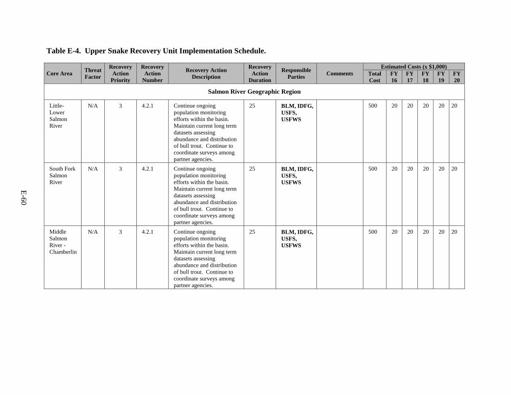
E-60
Table E-4. Upper Snake Recovery Unit Implementation Schedule.
Core Area Threat Factor
Recovery Action
Priority
Recovery Action
Number
Recovery Action Description
Recovery Action
Duration
Responsible Parties Comments
Estimated Costs (x $1,000) Total Cost
FY 16
FY 17
FY 18
FY 19
FY 20
Salmon River Geographic Region
Little-Lower Salmon River
N/A 3 4.2.1 Continue ongoing population monitoring efforts within the basin. Maintain current long term datasets assessing abundance and distribution of bull trout. Continue to coordinate surveys among partner agencies.
25 BLM, IDFG, USFS, USFWS
500 20 20 20 20 20
South Fork Salmon River
N/A 3 4.2.1 Continue ongoing population monitoring efforts within the basin. Maintain current long term datasets assessing abundance and distribution of bull trout. Continue to coordinate surveys among partner agencies.
25 BLM, IDFG, USFS, USFWS
500 20 20 20 20 20
Middle Salmon River - Chamberlin
N/A 3 4.2.1 Continue ongoing population monitoring efforts within the basin. Maintain current long term datasets assessing abundance and distribution of bull trout. Continue to coordinate surveys among partner agencies.
25 BLM, IDFG, USFS, USFWS
500 20 20 20 20 20
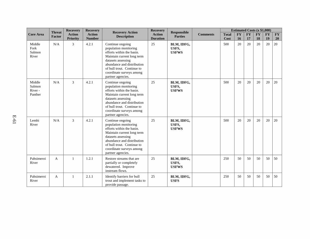
E-61
Core Area Threat Factor
Recovery Action
Priority
Recovery Action
Number
Recovery Action Description
Recovery Action
Duration
Responsible Parties Comments
Estimated Costs (x $1,000) Total Cost
FY 16
FY 17
FY 18
FY 19
FY 20
Middle Fork Salmon River
N/A 3 4.2.1 Continue ongoing population monitoring efforts within the basin. Maintain current long term datasets assessing abundance and distribution of bull trout. Continue to coordinate surveys among partner agencies.
25 BLM, IDFG, USFS, USFWS
500 20 20 20 20 20
Middle Salmon River - Panther
N/A 3 4.2.1 Continue ongoing population monitoring efforts within the basin. Maintain current long term datasets assessing abundance and distribution of bull trout. Continue to coordinate surveys among partner agencies.
25 BLM, IDFG, USFS, USFWS
500 20 20 20 20 20
Lemhi River
N/A 3 4.2.1 Continue ongoing population monitoring efforts within the basin. Maintain current long term datasets assessing abundance and distribution of bull trout. Continue to coordinate surveys among partner agencies.
25 BLM, IDFG, USFS, USFWS
500 20 20 20 20 20
Pahsimeroi River
A 1 1.2.1 Restore streams that are partially or completely dewatered. Improve instream flows.
25 BLM, IDFG, USFS, USFWS
250 50 50 50 50 50
Pahsimeroi River
A 1 2.1.1 Identify barriers for bull trout and implement tasks to provide passage.
25 BLM, IDFG, USFS
250 50 50 50 50 50
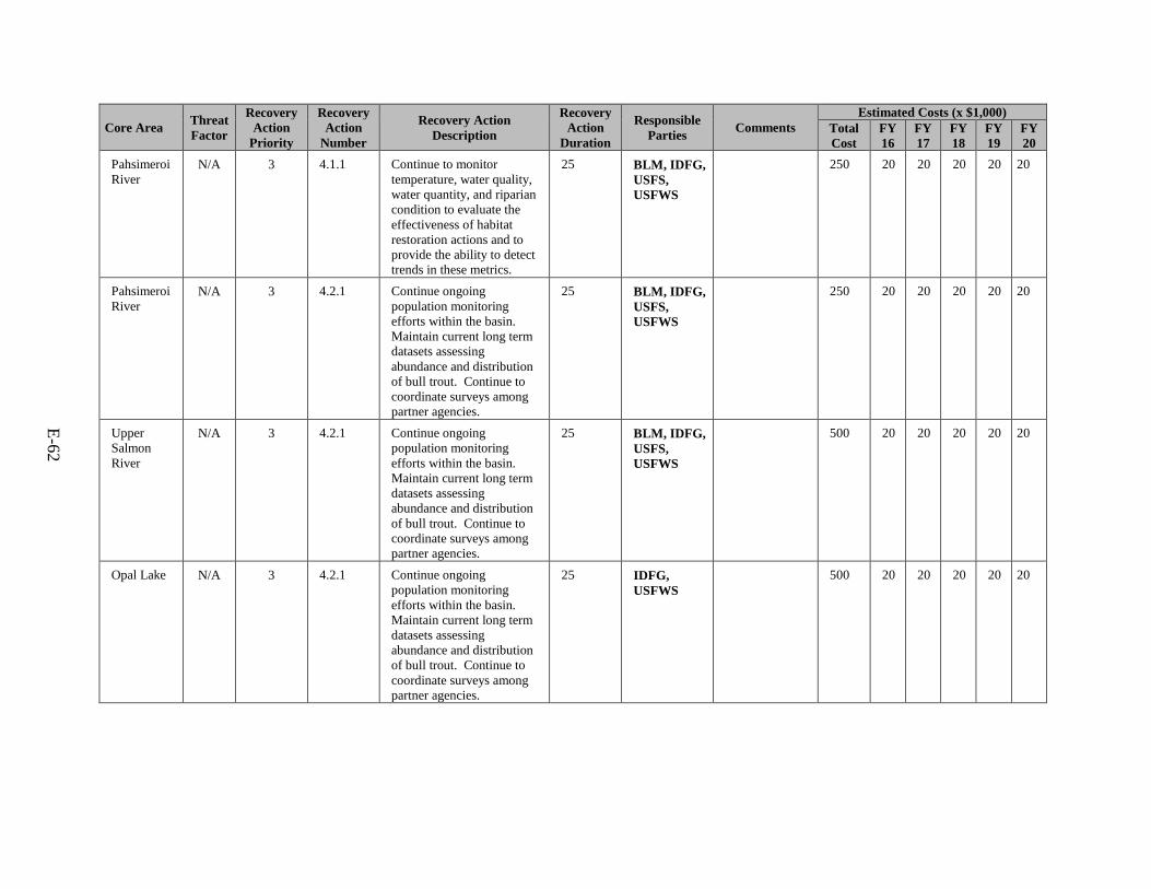
E-62
Core Area Threat Factor
Recovery Action
Priority
Recovery Action
Number
Recovery Action Description
Recovery Action
Duration
Responsible Parties Comments
Estimated Costs (x $1,000) Total Cost
FY 16
FY 17
FY 18
FY 19
FY 20
Pahsimeroi River
N/A 3 4.1.1 Continue to monitor temperature, water quality, water quantity, and riparian condition to evaluate the effectiveness of habitat restoration actions and to provide the ability to detect trends in these metrics.
25 BLM, IDFG, USFS, USFWS
250 20 20 20 20 20
Pahsimeroi River
N/A 3 4.2.1 Continue ongoing population monitoring efforts within the basin. Maintain current long term datasets assessing abundance and distribution of bull trout. Continue to coordinate surveys among partner agencies.
25 BLM, IDFG, USFS, USFWS
250 20 20 20 20 20
Upper Salmon River
N/A 3 4.2.1 Continue ongoing population monitoring efforts within the basin. Maintain current long term datasets assessing abundance and distribution of bull trout. Continue to coordinate surveys among partner agencies.
25 BLM, IDFG, USFS, USFWS
500 20 20 20 20 20
Opal Lake N/A 3 4.2.1 Continue ongoing population monitoring efforts within the basin. Maintain current long term datasets assessing abundance and distribution of bull trout. Continue to coordinate surveys among partner agencies.
25 IDFG, USFWS
500 20 20 20 20 20
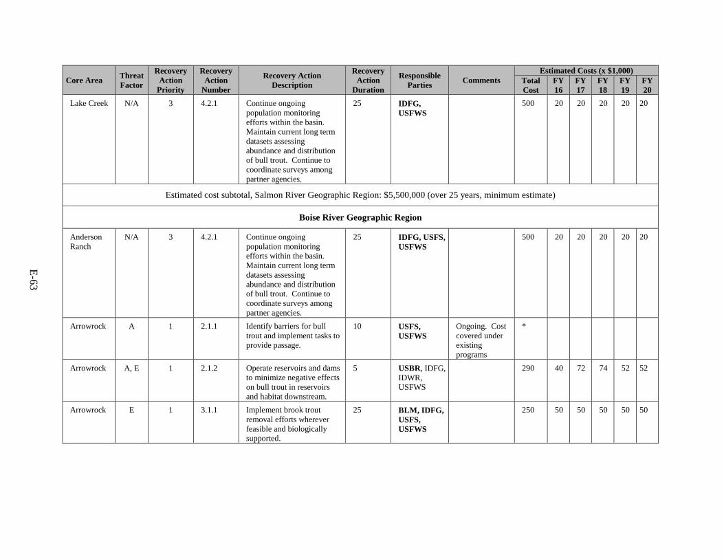
E-63
Core Area Threat Factor
Recovery Action
Priority
Recovery Action
Number
Recovery Action Description
Recovery Action
Duration
Responsible Parties Comments
Estimated Costs (x $1,000) Total Cost
FY 16
FY 17
FY 18
FY 19
FY 20
Lake Creek N/A 3 4.2.1 Continue ongoing population monitoring efforts within the basin. Maintain current long term datasets assessing abundance and distribution of bull trout. Continue to coordinate surveys among partner agencies.
25 IDFG, USFWS
500 20 20 20 20 20
Estimated cost subtotal, Salmon River Geographic Region: $5,500,000 (over 25 years, minimum estimate)
Boise River Geographic Region
Anderson Ranch
N/A 3 4.2.1 Continue ongoing population monitoring efforts within the basin. Maintain current long term datasets assessing abundance and distribution of bull trout. Continue to coordinate surveys among partner agencies.
25 IDFG, USFS, USFWS
500 20 20 20 20 20
Arrowrock A 1 2.1.1 Identify barriers for bull trout and implement tasks to provide passage.
10 USFS, USFWS
Ongoing. Cost covered under existing programs
*
Arrowrock A, E 1 2.1.2 Operate reservoirs and dams to minimize negative effects on bull trout in reservoirs and habitat downstream.
5 USBR, IDFG, IDWR, USFWS
290 40 72 74 52 52
Arrowrock E 1 3.1.1 Implement brook trout removal efforts wherever feasible and biologically supported.
25 BLM, IDFG, USFS, USFWS
250 50 50 50 50 50

E-64
Core Area Threat Factor
Recovery Action
Priority
Recovery Action
Number
Recovery Action Description
Recovery Action
Duration
Responsible Parties Comments
Estimated Costs (x $1,000) Total Cost
FY 16
FY 17
FY 18
FY 19
FY 20
Arrowrock N/A N/A 4.2.1 Continue ongoing population monitoring efforts within the basin. Maintain current long term datasets assessing abundance and distribution of bull trout. Continue to coordinate surveys among partner agencies.
25 IDFG, USFS, USFWS
500 20 20 20 20 20
Estimated cost subtotal, Boise River Geographic Region: $1,540,000 (over 25 years, minimum estimate)
Payette River Geographic Region
Squaw Creek
A 1 1.1.1 Implement actions necessary to accelerate recovery of riparian vegetation and streambanks and reduce negative effects from historic and current livestock grazing in identified problem areas.
25 IDFG, USFS, USFWS
500 20 20 20 20 20
Squaw Creek
A 1 2.1.1 Identify barriers for bull trout and implement tasks to provide passage.
10 USFS, IDFG, USFWS
Ongoing. Cost covered under existing programs
*
Squaw Creek
E 1 3.1.1 Implement brook trout removal efforts wherever feasible and biologically supported.
10 USFS, IDFG, USFWS
250 50 50 50 50 50
Squaw Creek
N/A 3 4.2.1 Continue ongoing population monitoring efforts within the basin. Maintain current long term datasets assessing abundance and distribution of bull trout. Continue to coordinate surveys among partner agencies.
25 IDFG, USFS, USFWS
500 20 20 20 20 20
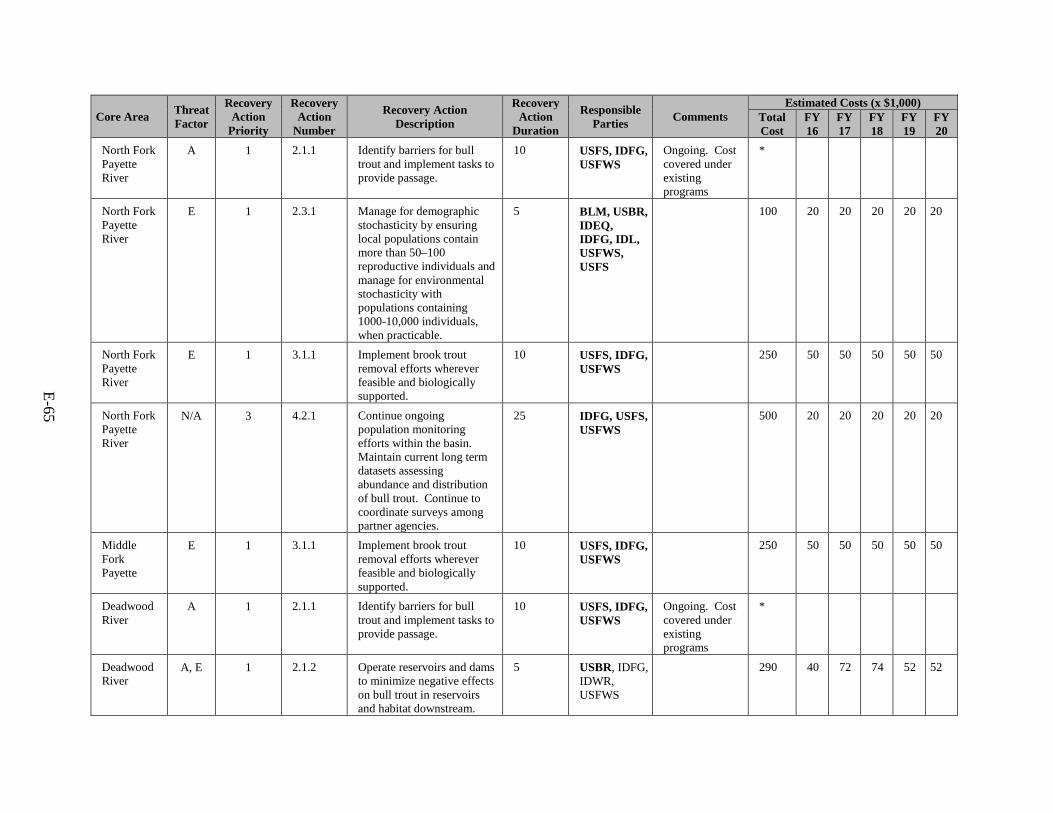
E-65
Core Area Threat Factor
Recovery Action
Priority
Recovery Action
Number
Recovery Action Description
Recovery Action
Duration
Responsible Parties Comments
Estimated Costs (x $1,000) Total Cost
FY 16
FY 17
FY 18
FY 19
FY 20
North Fork Payette River
A 1 2.1.1 Identify barriers for bull trout and implement tasks to provide passage.
10 USFS, IDFG, USFWS
Ongoing. Cost covered under existing programs
*
North Fork Payette River
E 1 2.3.1 Manage for demographic stochasticity by ensuring local populations contain more than 50–100 reproductive individuals and manage for environmental stochasticity with populations containing 1000-10,000 individuals, when practicable.
5 BLM, USBR, IDEQ, IDFG, IDL, USFWS, USFS
100 20 20 20 20 20
North Fork Payette River
E 1 3.1.1 Implement brook trout removal efforts wherever feasible and biologically supported.
10 USFS, IDFG, USFWS
250 50 50 50 50 50
North Fork Payette River
N/A 3 4.2.1 Continue ongoing population monitoring efforts within the basin. Maintain current long term datasets assessing abundance and distribution of bull trout. Continue to coordinate surveys among partner agencies.
25 IDFG, USFS, USFWS
500 20 20 20 20 20
Middle Fork Payette
E 1 3.1.1 Implement brook trout removal efforts wherever feasible and biologically supported.
10 USFS, IDFG, USFWS
250 50 50 50 50 50
Deadwood River
A 1 2.1.1 Identify barriers for bull trout and implement tasks to provide passage.
10 USFS, IDFG, USFWS
Ongoing. Cost covered under existing programs
*
Deadwood River
A, E 1 2.1.2 Operate reservoirs and dams to minimize negative effects on bull trout in reservoirs and habitat downstream.
5 USBR, IDFG, IDWR, USFWS
290 40 72 74 52 52
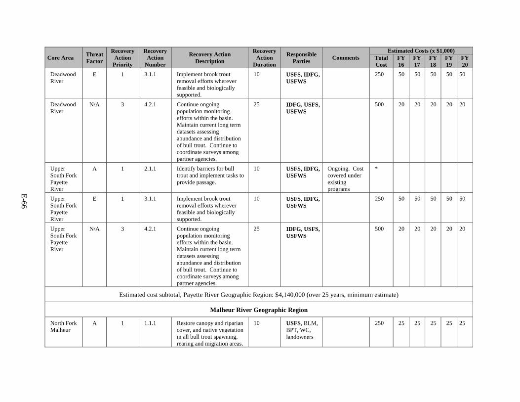
E-66
Core Area Threat Factor
Recovery Action
Priority
Recovery Action
Number
Recovery Action Description
Recovery Action
Duration
Responsible Parties Comments
Estimated Costs (x $1,000) Total Cost
FY 16
FY 17
FY 18
FY 19
FY 20
Deadwood River
E 1 3.1.1 Implement brook trout removal efforts wherever feasible and biologically supported.
10 USFS, IDFG, USFWS
250 50 50 50 50 50
Deadwood River
N/A 3 4.2.1 Continue ongoing population monitoring efforts within the basin. Maintain current long term datasets assessing abundance and distribution of bull trout. Continue to coordinate surveys among partner agencies.
25 IDFG, USFS, USFWS
500 20 20 20 20 20
Upper South Fork Payette River
A 1 2.1.1 Identify barriers for bull trout and implement tasks to provide passage.
10 USFS, IDFG, USFWS
Ongoing. Cost covered under existing programs
*
Upper South Fork Payette River
E 1 3.1.1 Implement brook trout removal efforts wherever feasible and biologically supported.
10 USFS, IDFG, USFWS
250 50 50 50 50 50
Upper South Fork Payette River
N/A 3 4.2.1 Continue ongoing population monitoring efforts within the basin. Maintain current long term datasets assessing abundance and distribution of bull trout. Continue to coordinate surveys among partner agencies.
25 IDFG, USFS, USFWS
500 20 20 20 20 20
Estimated cost subtotal, Payette River Geographic Region: $4,140,000 (over 25 years, minimum estimate)
Malheur River Geographic Region
North Fork Malheur
A 1 1.1.1 Restore canopy and riparian cover, and native vegetation in all bull trout spawning, rearing and migration areas.
10 USFS, BLM, BPT, WC, landowners
250 25 25 25 25 25
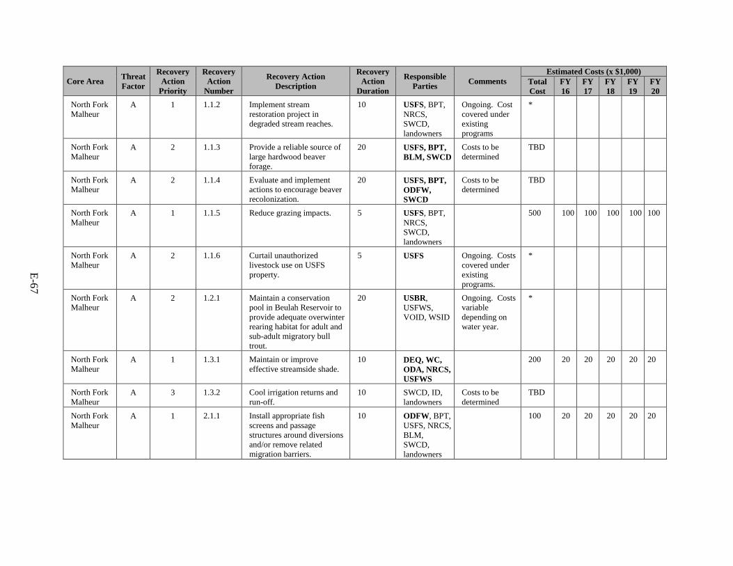
E-67
Core Area Threat Factor
Recovery Action
Priority
Recovery Action
Number
Recovery Action Description
Recovery Action
Duration
Responsible Parties Comments
Estimated Costs (x $1,000) Total Cost
FY 16
FY 17
FY 18
FY 19
FY 20
North Fork Malheur
A 1 1.1.2 Implement stream restoration project in degraded stream reaches.
10 USFS, BPT, NRCS, SWCD, landowners
Ongoing. Cost covered under existing programs
*
North Fork Malheur
A 2 1.1.3 Provide a reliable source of large hardwood beaver forage.
20 USFS, BPT, BLM, SWCD
Costs to be determined
TBD
North Fork Malheur
A 2 1.1.4 Evaluate and implement actions to encourage beaver recolonization.
20 USFS, BPT, ODFW, SWCD
Costs to be determined
TBD
North Fork Malheur
A 1 1.1.5 Reduce grazing impacts. 5 USFS, BPT, NRCS, SWCD, landowners
500 100 100 100 100 100
North Fork Malheur
A 2 1.1.6 Curtail unauthorized livestock use on USFS property.
5 USFS Ongoing. Costs covered under existing programs.
*
North Fork Malheur
A 2 1.2.1 Maintain a conservation pool in Beulah Reservoir to provide adequate overwinter rearing habitat for adult and sub-adult migratory bull trout.
20 USBR, USFWS, VOID, WSID
Ongoing. Costs variable depending on water year.
*
North Fork Malheur
A
1 1.3.1 Maintain or improve effective streamside shade.
10 DEQ, WC, ODA, NRCS, USFWS
200 20 20 20 20 20
North Fork Malheur
A 3 1.3.2 Cool irrigation returns and run-off.
10 SWCD, ID, landowners
Costs to be determined
TBD
North Fork Malheur
A 1 2.1.1 Install appropriate fish screens and passage structures around diversions and/or remove related migration barriers.
10 ODFW, BPT, USFS, NRCS, BLM, SWCD, landowners
100 20 20 20 20 20
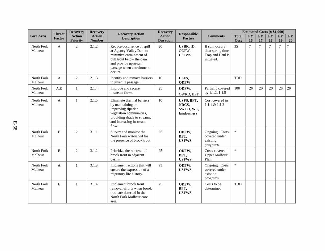
E-68
Core Area Threat Factor
Recovery Action
Priority
Recovery Action
Number
Recovery Action Description
Recovery Action
Duration
Responsible Parties Comments
Estimated Costs (x $1,000) Total Cost
FY 16
FY 17
FY 18
FY 19
FY 20
North Fork Malheur
A 2 2.1.2 Reduce occurrence of spill at Agency Valley Dam to minimize entrainment of bull trout below the dam and provide upstream passage when entrainment occurs.
20 USBR, ID, ODFW, USFWS
If spill occurs then spring time Trap and Haul is initiated.
35 7 7 7 7 7
North Fork Malheur
A 2 2.1.3 Identify and remove barriers to juvenile passage.
10 USFS, ODFW
TBD
North Fork Malheur
A,E 1 2.1.4 Improve and secure instream flows.
25 ODFW, OWRD, BPT
Partially covered by 1.1.2, 1.1.5
100 20 20 20 20 20
North Fork Malheur
A 1 2.1.5 Eliminate thermal barriers by maintaining or improving riparian vegetation communities, providing shade to streams, and increasing instream flow.
10 USFS, BPT, NRCS, SWCD, WC, landowners
Cost covered in 1.1.1 & 1.1.2
North Fork Malheur
E 2 3.1.1 Survey and monitor the North Fork watershed for the presence of brook trout.
25 ODFW, BPT, USFWS
Ongoing. Costs covered under existing programs.
*
North Fork Malheur
E 2 3.1.2 Prioritize the removal of brook trout in adjacent basins.
25 ODFW, BPT, USFWS
Costs covered in Upper Malheur Plan.
*
North Fork Malheur
A 1 3.1.3 Implement actions that will ensure the expression of a migratory life history.
25 ODFW, USFWS
Ongoing. Costs covered under existing programs.
*
North Fork Malheur
E 1 3.1.4 Implement brook trout removal efforts when brook trout are detected in the North Fork Malheur core area.
25 ODFW, BPT, USFWS
Costs to be determined
TBD
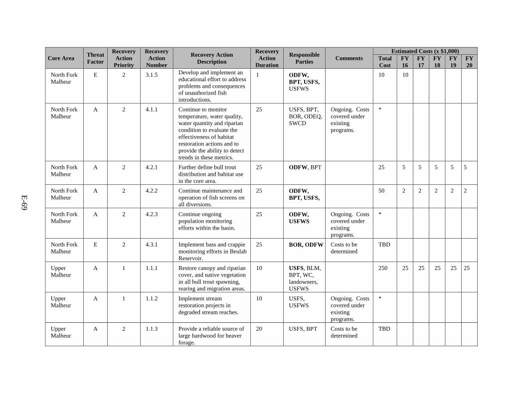
E-69
Core Area Threat Factor
Recovery Action
Priority
Recovery Action
Number
Recovery Action Description
Recovery Action
Duration
Responsible Parties Comments
Estimated Costs (x $1,000) Total Cost
FY 16
FY 17
FY 18
FY 19
FY 20
North Fork Malheur
E 2 3.1.5 Develop and implement an educational effort to address problems and consequences of unauthorized fish introductions.
1 ODFW, BPT, USFS, USFWS
10 10
North Fork Malheur
A 2 4.1.1 Continue to monitor temperature, water quality, water quantity and riparian condition to evaluate the effectiveness of habitat restoration actions and to provide the ability to detect trends in these metrics.
25 USFS, BPT, BOR, ODEQ, SWCD
Ongoing. Costs covered under existing programs.
*
North Fork Malheur
A 2 4.2.1 Further define bull trout distribution and habitat use in the core area.
25 ODFW, BPT 25 5 5 5 5 5
North Fork Malheur
A 2 4.2.2 Continue maintenance and operation of fish screens on all diversions.
25 ODFW, BPT, USFS,
50 2 2 2 2 2
North Fork Malheur
A 2 4.2.3 Continue ongoing population monitoring efforts within the basin.
25 ODFW, USFWS
Ongoing. Costs covered under existing programs.
*
North Fork Malheur
E 2 4.3.1 Implement bass and crappie monitoring efforts in Beulah Reservoir.
25 BOR, ODFW Costs to be determined
TBD
Upper Malheur
A 1 1.1.1 Restore canopy and riparian cover, and native vegetation in all bull trout spawning, rearing and migration areas.
10 USFS, BLM, BPT, WC, landowners, USFWS
250 25 25 25 25 25
Upper Malheur
A 1 1.1.2 Implement stream restoration projects in degraded stream reaches.
10 USFS, USFWS
Ongoing. Costs covered under existing programs.
*
Upper Malheur
A 2 1.1.3 Provide a reliable source of large hardwood for beaver forage.
20 USFS, BPT Costs to be determined
TBD
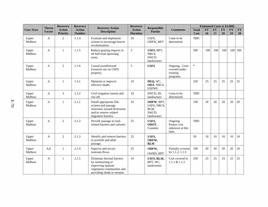
E-70
Core Area Threat Factor
Recovery Action
Priority
Recovery Action
Number
Recovery Action Description
Recovery Action
Duration
Responsible Parties Comments
Estimated Costs (x $1,000) Total Cost
FY 16
FY 17
FY 18
FY 19
FY 20
Upper Malheur
A 2 1.1.4 Evaluate and implement actions to encourage beaver recolonization.
20 USFS, ODFW, BPT
Costs to be determined
TBD
Upper Malheur
A 1 1.1.5 Reduce grazing impacts in all bull trout spawning areas.
5 USFS, BPT, NRCS, SWCD, landowners
500 100 100 100 100 100
Upper Malheur
A 2 1.1.6 Curtail unauthorized livestock use on USFS property.
5 USFS Ongoing. Costs covered under existing programs.
*
Upper Malheur
A 1 1.3.1 Maintain or improve effective shade.
10 DEQ, WC, ODA, NRCS, USFWS
250 25 25 25 25 25
Upper Malheur
A 3 1.3.2 Cool irrigation returns and run-off.
10 SWCD, ID, landowners
Costs to be determined.
TBD
Upper Malheur
A 1 2.1.1 Install appropriate fish screens and passage structures around diversions and/or remove related migration barriers.
10 ODFW, BPT, USFS, NRCS, BLM, SWCD, landowners
100 20 20 20 20 20
Upper Malheur
A 2 2.1.2 Provide passage at road-related barriers and culverts.
25 USFS, ODOT, Counties
Ongoing. Project cost unknown at this time.
TBD
Upper Malheur
A 2 2.1.3 Identify and remove barriers to juvenile and adult passage.
25 USFS, ODFW, BLM
50 10 10 10 10 10
Upper Malheur
A,E 1 2.1.4 Improve and secure instream flows.
25 ODFW, OWRD, BPT
Partially covered by 1.1.2, 1.1.5
100 20 20 20 20 20
Upper Malheur
A 1 2.1.5 Eliminate thermal barriers by maintaining or improving riparian vegetation communities and providing shade to streams.
10 USFS, BLM, BPT, WC, landowners
Cost covered in 1.1.1 & 1.1.2
250 25 25 25 25 25
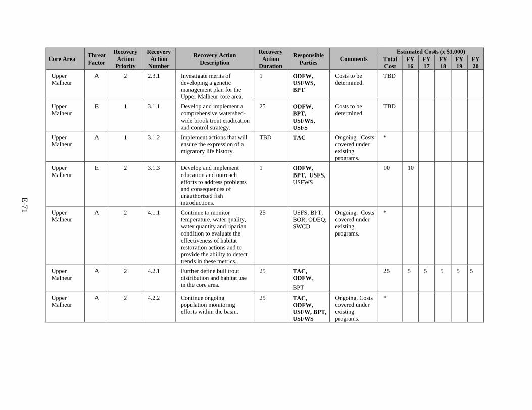
E-71
Core Area Threat Factor
Recovery Action
Priority
Recovery Action
Number
Recovery Action Description
Recovery Action
Duration
Responsible Parties Comments
Estimated Costs (x $1,000) Total Cost
FY 16
FY 17
FY 18
FY 19
FY 20
Upper Malheur
A 2 2.3.1 Investigate merits of developing a genetic management plan for the Upper Malheur core area.
1 ODFW, USFWS, BPT
Costs to be determined.
TBD
Upper Malheur
E 1 3.1.1 Develop and implement a comprehensive watershed-wide brook trout eradication and control strategy.
25 ODFW, BPT, USFWS, USFS
Costs to be determined.
TBD
Upper Malheur
A 1 3.1.2 Implement actions that will ensure the expression of a migratory life history.
TBD TAC Ongoing. Costs covered under existing programs.
*
Upper Malheur
E 2 3.1.3 Develop and implement education and outreach efforts to address problems and consequences of unauthorized fish introductions.
1 ODFW, BPT, USFS, USFWS
10 10
Upper Malheur
A 2 4.1.1 Continue to monitor temperature, water quality, water quantity and riparian condition to evaluate the effectiveness of habitat restoration actions and to provide the ability to detect trends in these metrics.
25 USFS, BPT, BOR, ODEQ, SWCD
Ongoing. Costs covered under existing programs.
*
Upper Malheur
A 2 4.2.1 Further define bull trout distribution and habitat use in the core area.
25 TAC, ODFW, BPT
25 5 5 5 5 5
Upper Malheur
A 2 4.2.2 Continue ongoing population monitoring efforts within the basin.
25 TAC, ODFW, USFW, BPT, USFWS
Ongoing. Costs covered under existing programs.
*
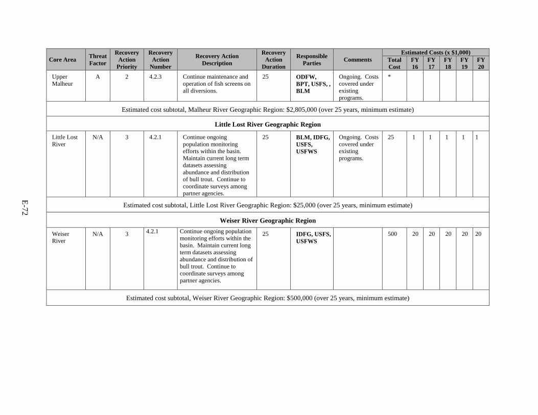
E-72
Core Area Threat Factor
Recovery Action
Priority
Recovery Action
Number
Recovery Action Description
Recovery Action
Duration
Responsible Parties Comments
Estimated Costs (x $1,000) Total Cost
FY 16
FY 17
FY 18
FY 19
FY 20
Upper Malheur
A 2 4.2.3 Continue maintenance and operation of fish screens on all diversions.
25 ODFW, BPT, USFS, , BLM
Ongoing. Costs covered under existing programs.
*
Estimated cost subtotal, Malheur River Geographic Region: $2,805,000 (over 25 years, minimum estimate)
Little Lost River Geographic Region
Little Lost River
N/A 3 4.2.1 Continue ongoing population monitoring efforts within the basin. Maintain current long term datasets assessing abundance and distribution of bull trout. Continue to coordinate surveys among partner agencies.
25 BLM, IDFG, USFS, USFWS
Ongoing. Costs covered under existing programs.
25 1 1 1 1 1
Estimated cost subtotal, Little Lost River Geographic Region: $25,000 (over 25 years, minimum estimate)
Weiser River Geographic Region
Weiser River
N/A 3 4.2.1 Continue ongoing population monitoring efforts within the basin. Maintain current long term datasets assessing abundance and distribution of bull trout. Continue to coordinate surveys among partner agencies.
25 IDFG, USFS, USFWS
500 20 20 20 20 20
Estimated cost subtotal, Weiser River Geographic Region: $500,000 (over 25 years, minimum estimate)
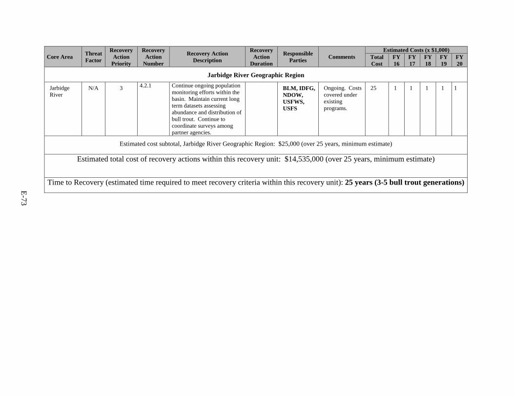
E-73
Core Area Threat Factor
Recovery Action
Priority
Recovery Action
Number
Recovery Action Description
Recovery Action
Duration
Responsible Parties Comments
Estimated Costs (x $1,000) Total Cost
FY 16
FY 17
FY 18
FY 19
FY 20
Jarbidge River Geographic Region
Jarbidge River
N/A 3 4.2.1 Continue ongoing population monitoring efforts within the basin. Maintain current long term datasets assessing abundance and distribution of bull trout. Continue to coordinate surveys among partner agencies.
BLM, IDFG, NDOW, USFWS, USFS
Ongoing. Costs covered under existing programs.
25 1 1 1 1 1
Estimated cost subtotal, Jarbidge River Geographic Region: $25,000 (over 25 years, minimum estimate)
Estimated total cost of recovery actions within this recovery unit: $14,535,000 (over 25 years, minimum estimate)
Time to Recovery (estimated time required to meet recovery criteria within this recovery unit): 25 years (3-5 bull trout generations)
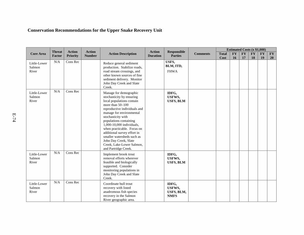
E-74
Conservation Recommendations for the Upper Snake Recovery Unit
Core Area Threat Factor
Action Priority
Action Number Action Description Action
Duration Responsible
Parties Comments Estimated Costs (x $1,000)
Total Cost
FY 16
FY 17
FY 18
FY 19
FY 20
Little-Lower Salmon River
N/A Cons Rec Reduce general sediment production. Stabilize roads, road stream crossings, and other known sources of fine sediment delivery. Monitor John Day Creek and Slate Creek.
USFS, BLM, ITD,
FHWA
Little-Lower Salmon River
N/A Cons Rec Manage for demographic stochasticity by ensuring local populations contain more than 50–100 reproductive individuals and manage for environmental stochasticity with populations containing 1,000-10,000 individuals, when practicable. Focus on additional survey effort in smaller watersheds such as John Day Creek, Slate Creek, Lake-Lower Salmon, and Partridge Creek.
IDFG, USFWS, USFS, BLM
Little-Lower Salmon River
N/A Cons Rec Implement brook trout removal efforts wherever feasible and biologically supported. Consider monitoring populations in John Day Creek and Slate Creek.
IDFG, USFWS, USFS, BLM
Little-Lower Salmon River
N/A Cons Rec Coordinate bull trout recovery with listed anadromous fish species recovery in the Salmon River geographic area.
IDFG, USFWS, USFS, BLM, NMFS
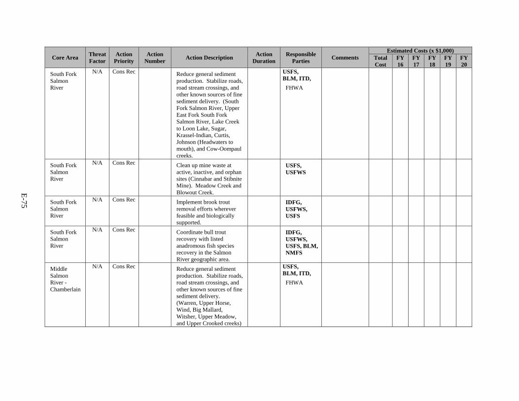
E-75
Core Area Threat Factor
Action Priority
Action Number Action Description Action
Duration Responsible
Parties Comments Estimated Costs (x $1,000)
Total Cost
FY 16
FY 17
FY 18
FY 19
FY 20
South Fork Salmon River
N/A Cons Rec Reduce general sediment production. Stabilize roads, road stream crossings, and other known sources of fine sediment delivery. (South Fork Salmon River, Upper East Fork South Fork Salmon River, Lake Creek to Loon Lake, Sugar, Krassel-Indian, Curtis, Johnson (Headwaters to mouth), and Cow-Oompaul creeks.
USFS, BLM, ITD,
FHWA
South Fork Salmon River
N/A Cons Rec Clean up mine waste at active, inactive, and orphan sites (Cinnabar and Stibnite Mine). Meadow Creek and Blowout Creek.
USFS, USFWS
South Fork Salmon River
N/A Cons Rec Implement brook trout removal efforts wherever feasible and biologically supported.
IDFG, USFWS, USFS
South Fork Salmon River
N/A Cons Rec Coordinate bull trout recovery with listed anadromous fish species recovery in the Salmon River geographic area.
IDFG, USFWS, USFS, BLM, NMFS
Middle Salmon River - Chamberlain
N/A Cons Rec Reduce general sediment production. Stabilize roads, road stream crossings, and other known sources of fine sediment delivery. (Warren, Upper Horse, Wind, Big Mallard, Witsher, Upper Meadow, and Upper Crooked creeks)
USFS, BLM, ITD,
FHWA
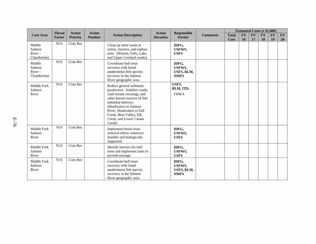
E-76
Core Area Threat Factor
Action Priority
Action Number Action Description Action
Duration Responsible
Parties Comments Estimated Costs (x $1,000)
Total Cost
FY 16
FY 17
FY 18
FY 19
FY 20
Middle Salmon River - Chamberlain
N/A Cons Rec Clean up mine waste at active, inactive, and orphan sites. (Warren, Falls, Lake, and Upper Crooked creeks)
IDFG, USFWS, USFS
Middle Salmon River - Chamberlain
N/A Cons Rec Coordinate bull trout recovery with listed anadromous fish species recovery in the Salmon River geographic area.
IDFG, USFWS, USFS, BLM, NMFS
Middle Fork Salmon River
N/A Cons Rec Reduce general sediment production. Stabilize roads, road stream crossings, and other known sources of fine sediment delivery. (Headwaters to Salmon River, Headwaters to Fall Creek, Bear Valley, Elk Creek, and Lower Camas Creek)
USFS, BLM, ITD,
FHWA
Middle Fork Salmon River
N/A Cons Rec Implement brook trout removal efforts wherever feasible and biologically supported.
IDFG, USFWS, USFS
Middle Fork Salmon River
N/A Cons Rec Identify barriers for bull trout and implement tasks to provide passage.
IDFG, USFWS, USFS
Middle Fork Salmon River
N/A Cons Rec Coordinate bull trout recovery with listed anadromous fish species recovery in the Salmon River geographic area.
IDFG, USFWS, USFS, BLM, NMFS
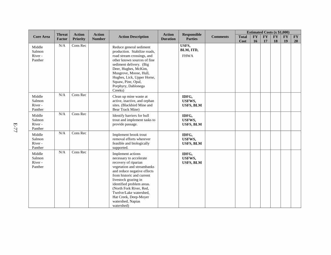
E-77
Core Area Threat Factor
Action Priority
Action Number Action Description Action
Duration Responsible
Parties Comments Estimated Costs (x $1,000)
Total Cost
FY 16
FY 17
FY 18
FY 19
FY 20
Middle Salmon River - Panther
N/A Cons Rec Reduce general sediment production. Stabilize roads, road stream crossings, and other known sources of fine sediment delivery. (Big Deer, Hughes, McKim, Musgrove, Moose, Hull, Hughes, Lick, Upper Horse, Squaw, Pine, Opal, Porphyry, Dahlonega Creeks)
USFS, BLM, ITD,
FHWA
Middle Salmon River - Panther
N/A Cons Rec Clean up mine waste at active, inactive, and orphan sites. (Blackbird Mine and Bear Track Mine)
IDFG, USFWS, USFS, BLM
Middle Salmon River - Panther
N/A Cons Rec Identify barriers for bull trout and implement tasks to provide passage.
IDFG, USFWS, USFS, BLM
Middle Salmon River - Panther
N/A Cons Rec Implement brook trout removal efforts wherever feasible and biologically supported.
IDFG, USFWS, USFS, BLM
Middle Salmon River - Panther
N/A Cons Rec Implement actions necessary to accelerate recovery of riparian vegetation and streambanks and reduce negative effects from historic and current livestock grazing in identified problem areas. (North Fork River, Red, Twelve/Lake watershed, Hat Creek, Deep-Moyer watershed, Napias watershed)
IDFG, USFWS, USFS, BLM

E-78
Core Area Threat Factor
Action Priority
Action Number Action Description Action
Duration Responsible
Parties Comments Estimated Costs (x $1,000)
Total Cost
FY 16
FY 17
FY 18
FY 19
FY 20
Middle Salmon River - Panther
N/A Cons Rec Coordinate bull trout recovery with listed anadromous fish species recovery in the Salmon River geographic area.
IDFG, USFWS, USFS, BLM, NMFS
Lemhi River N/A Cons Rec Identify barriers for bull trout and implement tasks to provide passage.
IDFG, USFWS, USFS, BLM
Lemhi River N/A Cons Rec Coordinate bull trout recovery with listed anadromous fish species recovery in the Salmon River geographic area.
IDFG, USFWS, USFS, BLM, NMFS
Lemhi River N/A Cons Rec Implement actions necessary to accelerate recovery of riparian vegetation and streambanks and reduce negative effects from historic and current livestock grazing in identified problem areas. (Hayden watershed, Little Eightmile, Canyon, Reservoir, Upper Texas, and Little Timber creeks)
IDFG, USFWS, USFS, BLM
Pahsimeroi River
N/A Cons Rec Implement actions necessary to accelerate recovery of riparian vegetation and streambanks and reduce negative effects from historic and current livestock grazing in identified problem areas.
IDFG, USFWS, USFS, BLM
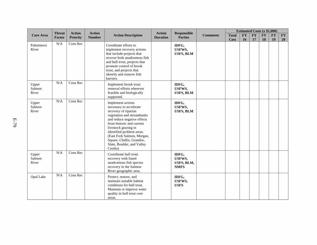
E-79
Core Area Threat Factor
Action Priority
Action Number Action Description Action
Duration Responsible
Parties Comments Estimated Costs (x $1,000)
Total Cost
FY 16
FY 17
FY 18
FY 19
FY 20
Pahsimeroi River
N/A Cons Rec Coordinate efforts to implement recovery actions that include projects that recover both anadromous fish and bull trout, projects that promote control of brook trout, and projects that identify and remove fish barriers.
IDFG, USFWS, USFS, BLM
Upper Salmon River
N/A Cons Rec Implement brook trout removal efforts wherever feasible and biologically supported.
IDFG, USFWS, USFS, BLM
Upper Salmon River
N/A Cons Rec Implement actions necessary to accelerate recovery of riparian vegetation and streambanks and reduce negative effects from historic and current livestock grazing in identified problem areas. (East Fork Salmon, Morgan, Squaw, Challis, Grandiw, Slate, Boulder, and Valley Creeks)
IDFG, USFWS, USFS, BLM
Upper Salmon River
N/A Cons Rec Coordinate bull trout recovery with listed anadromous fish species recovery in the Salmon River geographic area.
IDFG, USFWS, USFS, BLM, NMFS
Opal Lake N/A Cons Rec Protect, restore, and maintain suitable habitat conditions for bull trout. Maintain or improve water quality in bull trout core areas.
IDFG, USFWS, USFS
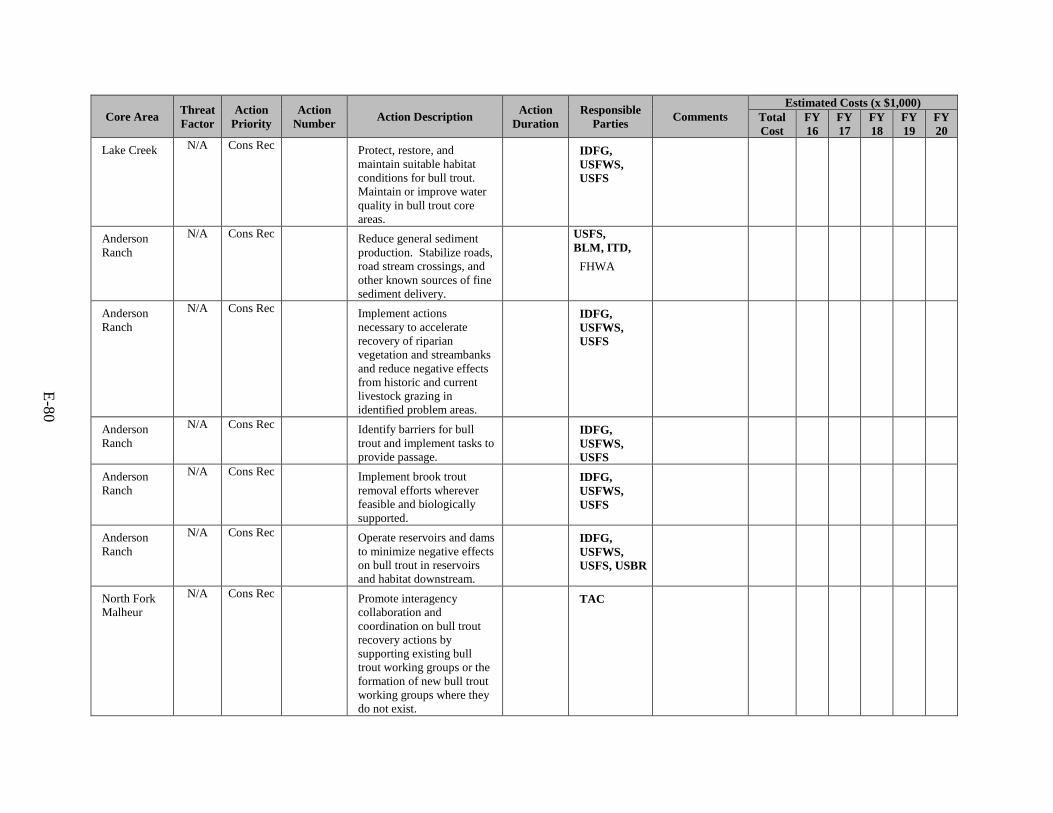
E-80
Core Area Threat Factor
Action Priority
Action Number Action Description Action
Duration Responsible
Parties Comments Estimated Costs (x $1,000)
Total Cost
FY 16
FY 17
FY 18
FY 19
FY 20
Lake Creek N/A Cons Rec Protect, restore, and maintain suitable habitat conditions for bull trout. Maintain or improve water quality in bull trout core areas.
IDFG, USFWS, USFS
Anderson Ranch
N/A Cons Rec Reduce general sediment production. Stabilize roads, road stream crossings, and other known sources of fine sediment delivery.
USFS, BLM, ITD,
FHWA
Anderson Ranch
N/A Cons Rec Implement actions necessary to accelerate recovery of riparian vegetation and streambanks and reduce negative effects from historic and current livestock grazing in identified problem areas.
IDFG, USFWS, USFS
Anderson Ranch
N/A Cons Rec Identify barriers for bull trout and implement tasks to provide passage.
IDFG, USFWS, USFS
Anderson Ranch
N/A Cons Rec Implement brook trout removal efforts wherever feasible and biologically supported.
IDFG, USFWS, USFS
Anderson Ranch
N/A Cons Rec Operate reservoirs and dams to minimize negative effects on bull trout in reservoirs and habitat downstream.
IDFG, USFWS, USFS, USBR
North Fork Malheur
N/A Cons Rec Promote interagency collaboration and coordination on bull trout recovery actions by supporting existing bull trout working groups or the formation of new bull trout working groups where they do not exist.
TAC
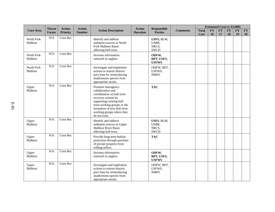
E-81
Core Area Threat Factor
Action Priority
Action Number Action Description Action
Duration Responsible
Parties Comments Estimated Costs (x $1,000)
Total Cost
FY 16
FY 17
FY 18
FY 19
FY 20
North Fork Malheur
N/A Cons Rec Identify and address sediment sources in North Fork Malheur Basin affecting bull trout.
USFS, BLM, USBR, NRCS, SWCD
North Fork Malheur
N/A Cons Rec Increase information outreach to anglers.
ODFW, BPT, USFS, USFWS
North Fork Malheur
N/A Cons Rec Investigate and implement actions to restore historic prey base by reintroducing anadromous species from appropriate stocks.
ODFW, BPT, USFWS, NMFS
Upper Malheur
N/A Cons Rec Promote interagency collaboration and coordination on bull trout recovery actions by supporting existing bull trout working groups or the formation of new bull trout working groups where they do not exist.
TAC
Upper Malheur
N/A Cons Rec Identify and address sediment sources in Upper Malheur River Basin affecting bull trout.
USFS, BLM, USBR, NRCS, SWCD
Upper Malheur
N/A Cons Rec Provide long-term habitat protection through purchase of private property from willing sellers.
TAC
Upper Malheur
N/A Cons Rec Increase information outreach to anglers.
ODFW, BPT, USFS, USFWS
Upper Malheur
N/A Cons Rec Investigate and implement actions to restore historic prey base by reintroducing anadromous species from appropriate stocks.
ODFW, BPT, USFWS, NMFS
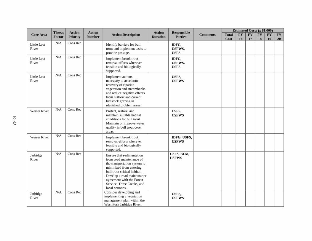
E-82
Core Area Threat Factor
Action Priority
Action Number Action Description Action
Duration Responsible
Parties Comments Estimated Costs (x $1,000)
Total Cost
FY 16
FY 17
FY 18
FY 19
FY 20
Little Lost River
N/A Cons Rec Identify barriers for bull trout and implement tasks to provide passage.
IDFG, USFWS, USFS
Little Lost River
N/A Cons Rec Implement brook trout removal efforts wherever feasible and biologically supported.
IDFG, USFWS, USFS
Little Lost River
N/A Cons Rec Implement actions necessary to accelerate recovery of riparian vegetation and streambanks and reduce negative effects from historic and current livestock grazing in identified problem areas.
USFS, USFWS
Weiser River N/A Cons Rec Protect, restore, and maintain suitable habitat conditions for bull trout. Maintain or improve water quality in bull trout core areas.
USFS, USFWS
Weiser River N/A Cons Rec Implement brook trout removal efforts wherever feasible and biologically supported.
IDFG, USFS, USFWS
Jarbidge River
N/A Cons Rec Ensure that sedimentation from road maintenance of the transportation system is minimized from entering bull trout critical habitat. Develop a road maintenance agreement with the Forest Service, Three Creeks, and local counties.
USFS, BLM, USFWS
Jarbidge River
N/A Cons Rec Consider developing and implementing a vegetation management plan within the West Fork Jarbidge River.
USFS, USFWS
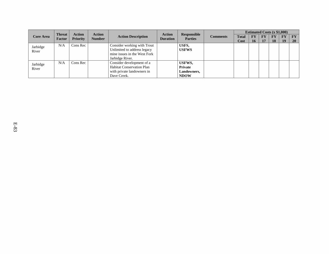
E-83
Core Area Threat Factor
Action Priority
Action Number Action Description Action
Duration Responsible
Parties Comments Estimated Costs (x $1,000)
Total Cost
FY 16
FY 17
FY 18
FY 19
FY 20
Jarbidge River
N/A Cons Rec Consider working with Trout Unlimited to address legacy mine issues in the West Fork Jarbidge River.
USFS, USFWS
Jarbidge River
N/A Cons Rec Consider development of a Habitat Conservation Plan with private landowners in Dave Creek.
USFWS, Private Landowners, NDOW
E-84
References Literature Cited
Batt, P. E. 1996. State of Idaho Bull Trout Conservation Plan. Office of the Governor of the State of Idaho, July 1, 1996.
Battin, J., M. W. Wiley, M. H. Ruckelshaus, R. N. Palmer, E. Korb, K. K. Bartz, and H. Imaki. 2007. Projected impacts of climate change on salmon habitat restoration. Proceedings of the National Academy of Sciences of the United States of America 104(16): 6720-6725.
Bengeyfield, P. 2006. Managing cows with streams in mind. Rangelands 28:3-6.
Buchanan, D. V. and S. V. Gregory. 1997. Development of water temperature standards to protect and restore habitat for bull trout and other cold water species in Oregon. Pages 1-9 in: W. C. Mackay, M. K. Brewin and M. Monita, editors. Bull Trout II Conference. Proceedings. Trout Unlimited Canada, Calgary, Alberta.
Burton, T. A., S. J. Smith, and E. R. Cowley. 2011. Riparian area management: Multiple indicator monitoring (MIM) of stream channels and streamside vegetation. Technical Reference 1737-23. BLM/OC/ST-10/003+1737+REV. U.S. Department of the Interior, Bureau of Land Management, National Operations Center, Denver, Colorado. 155 pp.
Clary, W. P., and B. F. Webster. 1989. Managing grazing of riparian areas in the Intermountain Region. General Technical Report INT-263. USDA Forest Service, Intermountain Research Station. Ogden, Utah.
DeHaan, P. W., M. Diggs and W. R. Ardren. 2007. Genetic population structure of bull trout in the Malheur River basin, Oregon. Report to the Burns Paiute Tribe, Burns, Oregon. September 28, 2007. 14 pages.
[EPA] Environmental Protection Agency. Northwest Impacts. Webpage accessed August 24, 2015. http://www.epa.gov/climatechange/impacts-adaptation/northwest.html.
Falke, J. A., Flitcroft, R. L., Dunham, J. B., McNyset, K. M., Hessburg, P. F., Reeves, G. H., 2015. Climate change and vulnerability of bull trout (Salvelinus confluentus) in a fire-prone landscape. DOI- 10.1139/cjfas-2014-0098: Canadian Journal Fisheries and Aquatic Sciences 72:304-318.
Goss, L. 2013. Livestock disturbance protocols: understanding the relationship between bank alteration and stream conditions. Master’s Thesis. Utah State University.
Hari, R. E., D. M. Livingstone, R. Siber, P. Burkhardt-Holm, and H. Guttinger. 2006. Consequences of climatic change for water temperature and brown trout populations in alpine rivers and streams. Global Change Biology 12:10–26.
E-85
[IDFG] High, B, Meyer, K., Schill, D., and E. Mamer. 2005. Bull trout status review and assessment in the State of Idaho. Grant #F-73-R-27. Idaho Department of Fish and Game. 57pp.
[IDFG] High, B, Meyer, K., Schill, D., and E. Mamer. 2008. Distribution, abundance, and population trends of bull trout in Idaho. North American Journal of Fisheries Management 28:1687-1701.
[IPCC] Intergovernmental Panel on Climate Change. 2007. Climate change 2007: the physical science basis. Available at www.ipcc.ch. (February 2007).
Isaak, D. J., M. K. Young, D. E. Nagel, D. L. Horan, and M. C. Groce. 2015. The cold-water climate shield: delineating refugia for preserving salmonid fishes through the 21st century. Global Change Biology, DOI:10.1111/gcb.12879.
ISAB (Independent Scientific Advisory Board). 2007. Climate change impacts on Columbia River basin fish and wildlife. ISAB 2007-2. Portland, Oregon. 2007.
[LLRITAT] Little Lost River Interagency Technical Advisory Team. 1998. Little Lost River key watershed bull trout problem assessment. Prepared for the State of Idaho. June 29, 1998.
[IDFG] Meyer, K., Garton, E., and D. J. Schill. 2014. Bull trout trends in abundance and probabilities of persistence in Idaho. North American Journal of Fisheries Management. 34:1, 202-214.
Montana Bull Trout Restoration Team. 2000. Restoration Plan for bull trout in the Clark Fork River Basin and Kootenai River Basin, Montana. Montana Fish, Wildlife and Parks, Helena, Montana.
Petersen, J. H., and E. E. Kofoot. 2002. Conditions for growth and survival of bull trout in Beulah Reservoir, Oregon. Annual Report for 2001. Report to the U.S. Bureau of Reclamation, Pacific Northwest Region, Boise, Idaho. 43p.
Rieman, B. E., D. Isaak, S. Adams, D. Horan, D. Nagel, C. Luce, and D. Myers. 2007. Anticipated Climate Warming Effects on Bull Trout Habitats and Populations Across the Interior Columbia River Basin. Transactions of the American Fisheries Society 136:1552-1565.
[USFWS] U.S. Fish and Wildlife Service. 2002a. Draft recovery plan for bull trout (Salvelinus confluentus) in the coterminous United States: Klamath River and Columbia River Distinct Population Segments. U.S. Fish and Wildlife Service, Portland, Oregon.
[USFWS] U.S. Fish and Wildlife Service. 2002b. Draft recovery plan for bull trout (Salvelinus confluentus) in the coterminous United States: St. Mary-Belly River Distinct Population Segments. U.S. Fish and Wildlife Service, Portland, Oregon.
E-86
[USFWS] U.S. Fish and Wildlife Service. 2004a. Designation of critical habitat for the Klamath River and Columbia River populations of bull trout. Federal Register 69:59996-60075.
[USFWS] U.S. Fish and Wildlife Service. 2004b. Draft recovery plan for the Coastal-Puget Sound distinct population segment of bull trout (Salvelinus confluentus). Puget Sound Management Unit, Portland, Oregon. 389 + xvii p.
[USFWS] U.S. Fish and Wildlife Service. 2004c. Draft recovery plan for the Jarbidge River distinct population segment of bull trout (Salvelinus confluentus). Portland, Oregon. 132 + xiii p.
[USFWS] U.S. Fish and Wildlife Service. 2005a. Endangered and threatened wildlife and plants; designation of critical habitat for the bull trout. September 26, 2005. 70 FR 56212-56311.
[USFWS] U.S. Fish and Wildlife Service. 2005b. Bull trout core area templates - complete core area by core area analysis. W. Fredenberg and J. Chan, editors. U.S. Fish and Wildlife Service. Portland, Oregon.
[USFWS] U.S. Fish and Wildlife Service. 2005c. Bull trout core area conservation status assessment. W. Fredenberg, J. Chan, J. Young, and G. Mayfield. U.S. Fish and Wildlife Service. Portland, Oregon.
[USFWS] U.S. Fish and Wildlife Service. 2008. Bull trout core area templates - complete core area by core area re-analysis. W. Fredenberg and J. Chan, editors. U.S. Fish and Wildlife Service. Portland, Oregon.
[USFWS] U.S. Fish and Wildlife Service. 2010. Endangered and threatened wildlife and plants; revised designation of critical habitat for bull trout in the coterminous United States; final rule. October 18, 2010. Federal Register 75:63898-64070.
[USFWS] U.S. Fish and Wildlife Service. 2014. Revised draft recovery plan for the coterminous United States population of bull trout (Salvelinus confluentus). Portland, Oregon. xii + 151 pages.
[USFWS] U.S. Fish and Wildlife Service. 2015a. Recovery plan for the coterminous United States population of bull trout (Salvelinus confluentus). Portland, Oregon. xii + 179 pages.
[USFWS] U.S. Fish and Wildlife Service. 2015b. Draft Upper Snake Recovery Unit Implementation Plan for Bull Trout Recovery Plan. June 2015. Boise, Idaho. 110 pages.
[WWF] World Wildlife Fund. 2003. Buying time: a user’s manual for building resistance and resilience to climate change in natural systems. Editors: L. J. Hansen, J. L Biringer, and J. R. Hoffman.
E-87
Appendix I. Core Area Summaries
Summary for: Little Lower Salmon River Core Area
Geographic Description
This core area is located in Idaho County and extends from the watersheds of the confluence of the mainstem Salmon River with the Snake River, upstream to the confluence with French Creek. In addition, the Little Salmon River watershed is included, which flows into the Salmon River at River kilometer 139 (River Mile 86.7). The western boundary is formed by Hells Canyon on the north and by the Seven Devils Mountains on the south. The eastern boundary starting from the south is the watershed crest at the headwaters of the North Fork Payette River and it continues north and crosses the Salmon River below Burgdorf Summit. This boundary continues north to the headwaters of Little Slate Creek and White Bird Creek and curves to the west around the east side of the Craig Mountains. The core area is 455,160 hectares (1,124,700 acres) and the land ownership in this core area differs from other core areas in that it contains a larger amount (approximately 38 percent) of private land. The Bureau of Land Management (6 percent) and the U.S. Forest Service (47 percent) manage the majority of lands within the core area.
Current Distribution and Abundance
Bull trout are currently known to use spawning and rearing habitat in at least seven streams or stream complexes (i.e., local populations). These local populations include Slate Creek, John Day Creek, Rapid River, Boulder Creek, Hard Creek, Lake/Lower Salmon, and Partridge Creek.
The mainstem Salmon River provides for migration, and adult and sub adult foraging, rearing and wintering habitat. The Little Salmon River also provides for foraging/adult rearing habitat and connectivity between local populations in the core area.
Current trend information for the Rapid River portion of this core area shows that the population is increasing while surveys in Slate Creek and John Day indicate that those populations are decreasing. The Service will attempt to be conservative in identifying primary threats and conservation actions.

E-88
Threats:
• Degraded Habitat • Instream Flows • Livestock Grazing • Small Population • Brook trout
Primary Threats Proposed:
• brook trout • small population size

E-89
Summary for: South Fork Salmon River Core Area
Geographic Description
This core area occurs in Valley and Idaho Counties and enters the Mainstem Salmon River east of French Creek and extends south to its headwaters upstream of Warm Lake. The ridges that form the eastern boundary of this relatively narrow, north-south oriented area lie in the headwaters of the Middle Fork Salmon River and Big Creek. The western boundary is the divide between the upper North Fork Payette River and the South Fork Salmon River. The core area is 338,100 acres (835,000 hectares) in size.
The U.S. Forest Service manages 99 percent of the land in this core area.
Current Distribution and Abundance
Bull trout are currently known to use spawning and rearing habitat in at least 28 streams or stream complexes (i.e., local populations). These local populations include Upper Lake Creek, Grouse-Flat Creek, Ruby Creek, Summit Creek, Victor Creek, Loon Creek, Lick Creek, Zena Creek, Fitsum Creek, Buckhorn Creek, Cougar Creek, Fourmile Creek, Blackmare Creek, Dollar-Six Bit Creeks, Warm Lake, Curtis Creek, Upper South Fork Salmon River, Burntlog Creek, Trapper Creek, Riordan Lake, Upper East Fork South Fork Salmon River, Sugar Creek, Tamarack Creek, Profile Creek, Quartz Creek, Elk Creek, and Pony Creek.
Both resident and fluvial populations of bull trout were documented in the mainstem South Fork Salmon River. Overwintering fluvial bull trout were observed in the lower South Fork Salmon River from the Sheep Creek confluence downstream to the mouth of the South Fork Salmon River. Bull trout also overwintered in the mainstem Salmon River from the Elkhorn Creek confluence upstream to Big Mallard Creek.
IDFG trend data indicates that this core area is increasing.
Threats: (No Primary Threats – based on technical partners and IDFG 2014 trend data)
• Connectivity Impairment • Habitat Degradation • Brook Trout

E-90
Summary for: Middle Fork Salmon River - Chamberlain Core Area
Geographic Description
This core area is located in Idaho County and includes the Salmon River from its confluence with the Middle Fork Salmon River downstream to French Creek on the western boundary. The northern boundary is comprised of the peaks that separate the Salmon River basin from the Clearwater basin. The southern boundary follows the ridges between Farrow Mountain and Mosquito Peak and then continues to the mouth of the South Fork Salmon River. The core area covers 350,700 hectares (866,600 acres) and 99 percent of this area is managed by the Federal government.
Current Distribution and Abundance
Bull trout are currently known to use spawning and rearing habitat in at least nine streams or stream complexes (i.e., local populations). These local populations include Bargamin Creek, Warren Creek, Fall Creek, California Creek, Wind River, Sheep Creek, Big Squaw Creek, Sabe Creek, and Chamberlain Creek.
The mainstem Middle Fork Salmon River provides for migration, and adult and sub adult foraging, rearing and wintering habitat. Bull trout spawning and rearing occurs in the upper reaches of the creeks, and subadult and adult rearing occurs in the remainder of the drainages.
IDFG trend data indicates that this core area is increasing.
Threats: (No Primary Threats – based on technical partners and IDFG 2014 trend data)
None
E-91
Summary for: Middle Fork Salmon River Core Area
Geographic Description
This core area includes the entire Middle Salmon River drainage which lies in Idaho County and is mostly in the Frank Church River of No Return Wilderness. The southern boundary is in the headwaters of Bear Valley Creek and the mountains to the north of Big Creek from the northern boundary. The eastern boundary follows the ridge line of the high peaks west of Panther Creek the Main Salmon River, and McElney Mountain and Twin Peaks.
This area encompasses 744,300 hectares (1,839,000 acres) and 99 percent of this area is managed by the U.S. Forest Service.
Current Distribution and Abundance
Bull trout are currently known to use spawning and rearing habitat in at least 28 streams or stream complexes (i.e., local populations). These local populations include Bear Valley Creek, Marsh Creek, Upper Middle Fork Salmon River 1, Upper Middle Fork Salmon River 2, Mayfield Creek, Rapid Creek, Pistol Creek, Little Loon Creek, Warm Spring Creek, Loon Creek, Camas Creek, Lower Middle Fork Salmon River 1, Lower Middle Fork Salmon River 2, Lower Middle Fork Salmon River 3, Marble Creek, Monumental Creek, Big Raney Creek, Big Creek 1, Big Creek 2, Big Creek 3, Big Creek 4, Beaver Creek, Rush Creek, Silver Creek, Yellowjacket Creek, Wilson Creek, Indian Creek, and Sulphur Creek.
IDFG estimates that this core area contains some of the strongest bull trout local populations in the Pacific Northwest. The mainstem Middle Fork Salmon River provides for migration, and adult and sub adult foraging, rearing and wintering habitat. Bull trout spawning and rearing occurs in the upper reaches of the creeks, and subadult and adult rearing occurs in the remainder of the drainages.
IDFG trend data indicates that this core area is decreasing but technical partners determined that trends were stable.
Threats: (No Primary Threats – based on technical partners and IDFG 2014 trend data)
Brook trout

E-92
Summary for: Middle Salmon River- Panther Core Area
Geographic Description
The Middle Salmon River – Panther Creek core area is located in Lemhi and Idaho Counties. This area is bordered on the west by the mountains west of Panther Creek, the Bighorn Crags and Quartzite Mountain; the southeast boundary is the Lemhi Mountain Range; and the northeast boundary is the Bitterroot Mountain Range. The core area comprises 557,450 hectares (1,377,500 acres).
Land ownership in the Middle Salmon River - Panther basin is predominantly Federal. The U.S. Forest Service (86 percent) and the Bureau of Land Management (9 percent) manage the majority of lands within the core area. Privately owned lands make up about 5 percent of the total land in the basin.
Current Distribution and Abundance
Bull trout are currently known to use spawning and rearing habitat in at least 19 streams or stream complexes (i.e., local populations). These local populations include Cow Creek, Hat Creek, McKim Creek, Iron Creek, Williams Creek, Carmen Creek, Fourth of July Creek, Jesse Creek, Twelve Mile Creek, North Fork Salmon River, Indian Creek, Squaw Creek, Spring Creek, Owl Creek, Boulder Creek, Pine Creek, Horse Creek, Panther Creek, and Napias Creek. Most populations appear to exhibit resident life history expression.
They are also present in the mainstem Salmon and North Fork Salmon Rivers and in many streams of the Panther Creek drainage.
IDFG trend data indicates that this core area is decreasing but technical partners determined that trends were stable.
Threats: (No Primary Threats – based on technical partners and IDFG 2014 trend data)
• Livestock Grazing • Mining • Connectivity Impairment • Brook Trout

E-93
Summary for: Lemhi River Core Area
Geographic Description
The Lemhi River core area occurs in the Boise River basin and is located in Lemhi County. This core area includes the Lemhi River and is bordered by the rugged Bitterroot Range of the Beaverhead Mountains to the north and east and the Lemhi Mountain Range to the west.
The core area is 327,260 hectares (808,670 acres) with federally-managed land divided equally between the U.S. Forest Service (40 percent) and the Bureau of Land Management (39 percent); 19 percent is privately managed.
Current Distribution and Abundance
Bull trout are currently known to use spawning and rearing habitat in at least six streams or stream complexes (i.e., local populations). These local populations include Hayden Creek, Pattee Creek, Upper Lemhi River, Geertson Creek, Kenny Creek, and Bohannon Creek.
Most bull trout are found in isolated resident populations but the mainstem Lemhi River contains fluvial bull trout. Connectivity between the tributaries and the Lemhi River is reduced because of migration barriers. Hayden Creek has year-round connectivity to the Lemhi River and contains a fluvial population.
IDFG trend data indicates that this core area is increasing.
Threats: (No Primary Threats – based on technical partners and IDFG 2014 trend data)
• Connectivity Impairment • Habitat Degradation
E-94
Summary for: Pahsimeroi River Core Area
Geographic Description
The Pahsimeroi River core area is located in the Upper Salmon River basin, in Lemhi and Custer Counties. The Pahsimeroi River watershed is located on the east side of the Salmon River, and includes the west slope of the Lemhi Mountain Range and the east slope of the Pahsimeroi Mountains in the Lost River Range. The valley floor has a low elevation of 1,418 meters (4,648 feet) and is characterized by well-developed alluvial fans that extend from the mountain fronts to near the center of the valley floor. The boulder, cobble, and gravel fans cover a large underground reservoir which provides the majority of the water that emerges as springs along the valley floor. The main Pahsimeroi River switches to subterranean flow during the late summer and winter.
Ninety-one percent of the Pahsimeroi River core area is in public ownership. The U.S. Forest Service manages 46 percent of the land area. This core area also has the highest percentage of land managed by the Bureau of Land Management (42 percent) of any of the core areas in this recovery unit. The Pahsimeroi River core area covers 217,200 hectares (536,800 acres).
Current Distribution and Abundance
Bull trout are currently known to use spawning and rearing habitat in at least nine streams or stream complexes (i.e., local populations). These local populations include Upper Pahsimeroi River, Big Creek, Patterson Creek, Falls Creek, Morse Creek, Little Morgan Creek (includes the lower Pahsimeroi River), Tater Creek, Big Gulch, and Ditch Creek.
Bull trout in the Pahsimeroi core area are found in most of the tributaries that drain the eastern, southern and southwestern portion of the area. The creeks in Upper Pahsimeroi River were considered a population stronghold in the Pahsimeroi River core area during the Subbasin Review process. The mainstem Pahsimeroi River serves as a migratory corridor for fish access to the mainstem Salmon River but lacks connectivity in multiple places on the mainstem.
The trend information and total abundance for local populations in most of this core area are unknown at this time.
Major Threats:
• Connectivity Impairment • Instream Flows • Instream Structures
E-95
Summary for: Upper Salmon River Core Area
Geographic Description
This core area is located in Custer County and extends from the mouth of the Pahsimeroi River to the headwaters in the Sawtooth Mountains, including the mainstem Salmon River and tributaries. The area covers 6,242 square kilometers (2,410 square miles) and contains 5,230 kilometers (3,251 miles) of streams. Eighty-nine percent of this core area is in public ownership, and most of this public land is managed by the Federal government. The U.S. Forest Service manages 99 percent of the land in this core area.
Current Distribution and Abundance
Bull trout are currently known to use spawning and rearing habitat in at least 18 streams or stream complexes (i.e., local populations). These local populations include Valley Creek, Basin Creek, Yankee Fork Creek, Thompson Creek, Squaw Creek, Challis Creek, Garden Creek, Morgan Creek, East Fork Salmon River, Slate Creek, Warms Springs Creek, Fourth of July Creek, Germania Creek, Upper Salmon River, Alturas Lake Creek, Pettit Lake, Yellowbelly Creek, and Redfish Lake Creek.
Both resident and migratory (fluvial and adfluvial) bull trout are present in the Sawtooth Valley. The inlet of Alturas Lake has adfluvial bull trout and is one of the largest local populations in the Sawtooth Valley. There are approximately 9,200 km (5,700 miles) of streams in the Upper Salmon River sub-basin. The largest tributary of the sub-basin is the East Fork Salmon River, portions of which occur in the action area. Other major tributaries to the Salmon River in this sub-basin include portions of the Yankee Fork Salmon River, Kinnikinic Creek, Slate Creek, Thompson Creek, Garden Creek, Challis Creek, Squaw Creek, Bayhorse Creek, Peach Creek, and Warm Springs Creek.
Trend information from IDFG 2014 indicates that this core area is increasing.
Threats: (No Primary Threats – based on technical partners and IDFG 2014 trend data)
• Connectivity Impairment • Habitat Degradation • Brook Trout
E-96
Summary for: Lake Creek Core Area
Geographic Description
This core area includes an isolated bull trout population in Williams Lake and Lake Creek. The core area is located on the west side of the Salmon River between the mouth of the Pahsimeroi and Lemhi rivers, approximately 19 kilometers (12 miles) south of Salmon, Idaho. Williams Lake was formed 8,000 to 10,000 years ago when a massive landslide dammed a creek in the steep-sided canyon and created a uniform basin. No surface outlet exists to the lake. At the base of the landslide area that created the lake, a spring-fed stream is apparently connected to the lake. The elevation of the lake is 1,601 meters (5,250 feet) and the watershed of 4,554 hectares (11,245 acres) that surrounds the lake is 98 percent Federal land managed by the U.S. Forest Service and the Bureau of Land Management.
Current Distribution and Abundance
Bull trout are located in Williams Lake and upstream of the lake in Lake Creek. Bull trout comprise approximately 20 percent of the fish population in Williams Lake and their numbers appear to be stable but there is insufficient data to establish trend criteria for the small population in Lake Creek.
Water quality in Williams Lake in the Lake Creek core area upstream of Salmon, Idaho is impacted by recreational residential development surrounding the lake. Since this lake has no outlet, water quality has declined in recent years and may be impacting bull trout.
E-97
Summary for: Opal Lake Core Area
Geographic Description
This core area encompasses a small, isolated bull trout population in Opal Lake and upstream of the lake in Opal Creek. The area is located in the headwaters of the Panther Creek watershed and is encompassed by the Middle Salmon River-Panther core area. This natural lake has no outlet. The elevation of the lake is 2,300 meters (7,546 feet) and the watershed contains 518 hectares (1,280 acres). The entire area is managed by the U.S. Forest Service.
Current Distribution and Abundance
Bull trout have been located by the Idaho Department of Fish and Game in Opal Lake. The lake is oligotrophic (low nutrient levels and high dissolved oxygen) and has no outlet. Good spawning habitat is located upstream of the lake; however, no positive identification of redds has been made to date.
Insufficient data is available to establish trend criteria for the small population in Opal Lake.
E-98
Summary for: Anderson Ranch Core Area
Geographic Description
Anderson Ranch core area is located in the Boise River basin, in Camas and Elmore Counties. Anderson Ranch Dam on the South Fork Boise is the lower extent of the core area and presents an impassable barrier to upstream fish movement. The core area comprises approximately 257,700 hectares (636,970 acres).
Anderson Ranch Dam, on the South Fork Boise River, blocks access of bull trout residing in the lower South Fork Boise River, North Fork Boise River, and Middle Fork Boise River to the upper portion of the South Fork Boise River basin. The dam is approximately 100 meters (332 feet) tall and has no provisions for either upstream or downstream fish passage.
The Boise National Forest manages 85 percent of the watershed and private lands accounts for 11 percent.
Current Distribution and Abundance
Bull trout are currently known to use spawning and rearing habitat in at least 11 streams or stream complexes (i.e., local populations). These local populations include Elk Creek, Trinity Creek (including Parks Creek), Willow Creek, Deadwood Creek, Boardman Creek (including Smokey Dome Canyon), Skeleton Creek, Bear Creek, Ross Fork Creek (including Johnson Creek and upper S.F. Boise River), Emma Creek, Big Smokey Creek (including West Fork Big Smokey), and Bluff Creek.
Migratory bull trout abundance has been estimated in Anderson Ranch Reservoir. During 1999 through 2000, abundance of adult migratory bull trout in Anderson Ranch Reservoir was estimated at 368 individuals.
The trend information based on IDFG 2014 data indicates that the core area is increasing.
Threats: (No Primary Threats – based on technical partners and IDFG 2014 trend data)
None

E-99
Summary for: Arrowrock Core Area
Geographic Description
The Arrowrock core area is located in the Boise River basin, in Elmore and Boise Counties. Arrowrock Dam on the Boise River is the lower extent of the core area and presents an impassable barrier to upstream fish movement. The core area is approximately 315,800 hectares (780,300 acres). The Boise National Forest manages 89 percent of the watershed while private lands accounts for 5 percent.
Current Distribution and Abundance
Bull trout are currently known to use spawning and rearing habitat in at least 18 streams or stream complexes (i.e., local populations). These local populations include Upper Crooked River, Bear River, Bear Creek, Lodgepole Creek, Upper North Fork Boise River (including McLeod Creek, McPhearson Creek, Ballentyne Creek, and West Fork Creek), Cow Creek, Big Silver Creek, Johnson Creek, Blackwarrior Creek, Little Queens River, Queens River, Yuba River (including Trail Creek), Grouse Creek (Yuba River tributary), Decker Creek (Yuba River tributary), Buck Creek, Roaring River, Sheep Creek, and Rattlesnake Creek.
During 1996 through 1997, abundance of adult migratory bull trout (i.e., fish greater than 300 millimeters (12 inches)) in Arrowrock Reservoir was estimated at 471 individuals. Current adult abundance is unknown.
The trend information and total abundance for local populations in most of this core area are unknown at this time.
Threats: (Primary Threats Identified by technical partners)
• Connectivity Impairment • Habitat Degradation • Water Management • Nonnative fish
E-100
Summary for: Squaw Creek Core Area
Geographic Description
The Squaw Creek core area is located in the Payette River basin, in Gem, Boise, Washington, and Valley Counties. The Squaw Creek drainage joins the mainstem Payette River as part of the Black Canyon Reservoir. The core area is approximately 88,300 hectares (218,200 acres). The Boise National Forest manages 47 percent of the watershed while private lands accounts for 40 percent.
Current Distribution and Abundance
Bull trout are currently known to occur in at least four streams or stream complexes (i.e., local populations). These local populations include Squaw Creek, Third Fork Squaw Creek, Rammage Meadows, and Renwyck Creek.
Bull trout spawning and rearing habitat occurs only in the upper watersheds.
The trend information and total abundance for local populations in most of this core area are unknown at this time.
Major Threats: (Primary Threats Identified by technical partners)
• Connectivity Impairment • Nonnative fish • Livestock Grazing
E-101
Summary for: North Fork Payette River Core Area
Geographic Description
The North Fork Payette River core area is located in Valley County. The core area is approximately 159,900 hectares (395,150 acres) and is isolated upstream of Cascade Lake and a dam in the lower Gold Fork River. The U.S. Forest Service manages 47 percent of the watershed while private lands accounts for 38 percent.
Current Distribution and Abundance
Bull trout are currently known in only one stream, the Gold Fork River, in this core area.
Bull trout spawning and rearing habitat occurs only in the upper watersheds and populations appear to only be resident fish.
The trend information and total abundance for local populations in most of this core area are unknown at this time.
Threats:
• Passage barriers • Connectivity impairment • Small Populations

E-102
Summary for: Middle Fork Payette River Core Area
Geographic Description
The Middle Fork Payette River core area is located in both Boise and Valley counties. The South Fork Payette eventually becomes the Payette River from its’ confluence with the North Fork Payette River. The core area is approximately 88,400 hectares (218,500 acres) and is predominately Federal Lands. The Forest Service manages 95 percent of the watershed.
Current Distribution and Abundance
Bull trout are currently known in only three streams or stream complexes (i.e., local populations). These local populations include Upper Middle Fork Payette River (including Stoney Meadow Creek), Sixteen-to-one Creek, and Bull Creek.
Limited fluvial life history expression has been documented in this core area.
The trend information and total abundance for local populations in most of this core area are unknown at this time.
Threats: (Primary Threats Identified by technical partners)
• Nonnative fish
E-103
Summary for: Deadwood River Core Area
Geographic Description
The Deadwood River core area occurs is located in Valley County. The Deadwood River drainage eventually joins the Upper South Fork Payette River. Deadwood Dam created Deadwood Reservoir and forms an impassible barrier to fish movement. Bull trout in the upper Deadwood River and Deadwood Reservoir are isolated from fish in the lower Deadwood River and the South Fork Payette River watersheds. The core area is approximately 28,400 hectares (70,200 acres). The U.S. Forest Service manages 92 percent of the watershed.
Current Distribution and Abundance
Bull trout are currently known to in at least six streams or stream complexes (i.e., local populations). These local populations include Trail Creek, North Fork Beaver Creek, South Fork Beaver Creek, Wildbuck Creek, Upper Deadwood River, and Deer Creek.
Limited fluvial life history expression has been documented in this core area.
The trend information and total abundance for local populations in most of this core area are unknown at this time.
Threats: (Primary Threats identified by technical partners)
• Connectivity Impairment • Water management

E-104
Summary for: Upper South Fork Payette River Core Area
Geographic Description
The Upper South Fork Payette River core area is located in both Boise and Valley counties. The South Fork Payette River (SFPR) eventually becomes the Payette River from its’ confluence with the North Fork Payette River. The core area is approximately 173,700 hectares (429,200 acres) and is predominately Federal Lands. The U.S. Forest Service manages 95 percent of the watershed while private lands accounts for 1 percent.
Current Distribution and Abundance
Bull trout are currently known in only 11 streams or stream complexes (i.e., local populations). These local populations include Scott Creek, Warm Springs Creek (Deadwood tributary), Clear Creek, Eightmile Creek, Tenmile Creek, Chapman Creek, Warm Spring-Gates Creek (SFPR tributary), Canyon Creek, Wapiti Creek, Trail Creek, and Baron Creek.
Limited fluvial life history expression has been documented in this core area.
The trend information and total abundance for local populations in most of this core area are unknown at this time.
Technical partners also discussed both climate change and urban development. The Service considered these threats but determined that these threats are speculative in nature. The Service focused on threats that were known to occur or would likely occur. The Service elected to remove climate change as a threat. The best conservation action to potentially address climate change is improving or promoting connectivity between local populations and within core areas. The effects of climate change are also difficult to determine. We acknowledge that climate change will have effects but are uncertain when those impacts would occur.
Threats:
• Degraded Habitat • Nonnative fish
E-105
Summary for: North Fork Malheur River Core Area
Geographic Description
This core area is located in eastern Oregon, Grant, Baker, Malheur and Harney Counties. It includes the North Fork River from the headwaters and tributaries, downstream to and including Beulah Reservoir. The North Fork Malheur River is the most important of the tributaries in terms of fish habitat and bull trout abundance.
Current Distribution and Abundance
The five bull trout populations in this core area include: 1) Elk Creek, 2) Little Crane Creek, 3) Swamp Creek, 4) Sheep Creek, and 5) Horseshoe Creek. The North Fork Malheur River subpopulation was isolated by Agency Dam in 1934 (Buchanan and Gregory 1997). Buchanan and Gregory (1997) classified bull trout in the North Fork Malheur River as “of special concern”, which falls between a “low” and “moderate” risk level.
The five populations in this core area are spread over an isolated, large geographical area with multiple age classes, containing both resident and migratory (fluvial) fish. Bull trout were known to exist in the North Fork Malheur River watershed prior to 1992. Distribution in the North Fork Malheur River above Agency Dam has remained unchanged since the species was first documented there (Buchanan and Gregory 1997). In August 2010, two charr that looked like bull trout/brook trout hybrids were identified, through photos, in the Little Malheur River of the North Fork River.
Threats:
• brook trout • passage barriers • impaired stream habitat conditions • high stream temperatures
E-106
Summary for: Upper Malheur River Core Area
Geographic Description
This core area is located in eastern Oregon in Grant and Harney Counties and includes the mainstem Malheur River from the headwaters and tributaries, downstream to the town of Drewsey.
Current Distribution and Abundance
The three local bull trout populations in this core area include: 1) Lake Creek, 2) Meadow Fork Creek, and 3) Big Creek. The Upper Malheur River subpopulation was isolated by Warm Springs Dam in 1919 (Buchanan and Gregory 1997). Buchanan and Gregory (1997) classified bull trout in the Upper Malheur River as “high risk” of extinction.
The three populations in this core area are spread over a large geographical area with multiple age classes, containing both resident and fluvial fish. Recent information indicates that there is a high proportion of brook trout in the Upper Malheur River, resulting in impacts through hybridization and competition for resources. Brook trout have displaced bull trout from several historic tributaries (i.e., Summit, Bosonberg, McCoy and Corral Basin creeks) and affect over 60 percent of the bull trout population. An estimate of adult abundance for the Upper Malheur River local population is not available because of the inability to distinguish between bull trout and brook trout redds when not occupied.
Threats:
• brook trout • passage barriers • impaired stream habitat conditions • elevated stream temperatures

E-107
Summary for: Little Lost River Core Area
Geographic Description
The Little Lost River core area is located in Lemhi, Butte, and Custer Counties. The Little Lost River lies in a closed basin within the upper Snake River basin and encompasses an area of 252,003 hectares (622,440 acres).
Land ownership in the Little Lost River basin is mixed. The Bureau of Land Management (43 percent) and the U.S. Forest Service (43 percent) manage the majority of lands within the recovery unit (LLRITAT 1998). Privately owned lands make up about 9 percent of the total land in the basin. The Idaho Department of Lands manages small land parcels interspersed within lands administered by the Bureau of Land Management.
Current Distribution and Abundance
Bull trout are currently known to use spawning and rearing habitat in at least 10 streams or stream complexes (i.e., local populations). These local populations include Badger Creek (including Bunting Canyon Creek), Williams Creek, Wet Creek (including Big Creek), Warm Creek, Squaw Creek (tributary to Sawmill Creek), Mill Creek, Iron Creek (including Hawley and Jackson creeks), Timber Creek (including Camp, Redrock and Slide creeks), Smithie Fork Creek, Upper Little Lost River (Iron Creek confluence to headwaters excluding the Timber Creek), and Smithie Fork Creek watersheds).
Abundance of bull trout (expressed as density, or the number of individuals per kilometer of stream) has declined in some areas of the Little Lost River and its tributaries. Both resident and migratory (fluvial) bull trout exist in the Little Lost River core area. Numerous connectivity projects have occurred in the main stem of the Little Lost River. Bull trout in the Little Lost River below Iron Creek road are fluvial and migrate to headwater streams to spawn. The primary spawning areas for fluvial bull trout appear to be tributary streams in Sawmill Canyon.
The trend information from IDFG in 2014 indicates that the core area is stable.
Threats: (No Primary Threats – based on technical partners and IDFG 2014 trend data)
• Connectivity Impairment • Livestock Grazing
E-108
Summary for: Jarbidge River Core Area
Area Description
The Jarbidge River core area is located in Elko County, Nevada and Owyhee County, Idaho. The Jarbidge River core area includes the entire Jarbidge River drainage and the portion of the Bruneau River from the confluence of the Jarbidge River to Hot Springs Idaho (Buckaroo Diversion). The core area is approximately 854,700 hectares (8,547 square kilometers) (2,112,000 acres) (3,300 square miles). Elevations range from 792 meters (2,600 feet) Bruneau River at Hot Springs, Idaho to over 3,306 meters (10,839 feet) (Matterhorn Peak) at the headwaters. Major tributaries within the core area include East and West Fork Jarbidge River, Dave Creek, Jack Creek, Pine Creek and Slide Creek.
Land managers within the core area include the Humboldt National Forest, Bureau of Land Management, State of Idaho, and some small parcels of private lands. The Humboldt National Forest manages most of the watershed with the majority in the Jarbidge Wilderness. Nevada Department of Wildlife manages fisheries resources within the majority of this core area.
Current Distribution and Abundance
Bull trout are currently known to use spawning and rearing habitat in at least six streams or stream complexes (i.e., local populations). These local populations include Dave Creek, East Fork Jarbidge River, Jack Creek, Pine Creek, Slide Creek and West Fork Jarbidge River. A tracking study documented bull trout population connectivity between many of the local populations, in particular between West Fork Jarbidge River and Pine Creek. Movement between the East and West Fork Jarbidge River was also documented. Much of the movement was in the autumn concurrent with decreasing water temperatures. The majority of bull trout that emigrated were age-2 or older fish with increased movement with age and evidence of substantial amount of fluvial life history.
Trend information and total abundance for local populations in most of this core area are unknown at this time.
Threats: (No Primary Threats – based on technical partners and IDFG 2014 trend data)
• Upland/Riparian Management
E-109
Summary for: Weiser River Core Area
Geographic Description
The Weiser River core area occurs in both Adams and Washington counties. The drainage joins the Snake River as part of the Brownlee Reservoir. The core area is approximately 245,500 hectares (606,700 acres). The Forest Service manages 44 percent of the watershed while private lands accounts for 40 percent.
Current Distribution and Abundance
Bull trout are currently known to in at least five streams or stream complexes (i.e., local populations). These local populations include Upper Hornet Creek, East Fork Weiser River, Upper Little Weiser River, Anderson Creek, and Sheep Creek.
Bull trout spawning and rearing habitat occurs only in the upper watersheds on Federal and State of Idaho lands. There is no connectivity between the current three stream complexes (Hornet Creek, Anderson Creek, and East Fork Weiser River.
IDFG indicated in 2014 that trend was increasing.
Threats: (Primary Threats – none)
• Habitat Degradation – water quality
E-110
Appendix II. Summary of the Comments on the Draft Recovery Unit Implementation Plan for the Upper Snake Recovery Unit
Background
On June 4, 2015, we released draft recovery unit implementation plans addressing each of the six recovery units that comprise the coterminous United States population of bull trout for a 45-day comment period for Federal agencies, Native American Tribes, State and local governments, and members of the public. The public comment period ended on July 20, 2015.
This section provides a summary of general information about the comments received on the Draft Upper Snake RUIP (USFWS 2015b), including the numbers and breakdown of comments (letters) from various sources.
We received 11 comment letters for the Upper Snake Recovery Unit. Comment letters were received from the following:
Federal Agencies (5)
State Agencies (2)
Native American Tribes (1)
Environmental/Conservation Organizations (2)
Individuals (1)
Public comments ranged from editorial suggestions to providing new information. As appropriate, we have incorporated all applicable edits and suggestions into the text of the final Upper Snake RUIP. The following is a summary of substantive comments, and our responses to those comments and suggestions, that were either not incorporated into the Upper Snake RUIP or that were incorporated partially or fully but need additional explanation or justification. General or global comments pertaining to rangewide recovery issues for bull trout are addressed in Appendix D of the final recovery plan (USFWS 2015a).
1. Comment: Numerous commenters suggested revisions or changes in the list of threats and/or proposed recovery measures for the Upper Snake Recovery Unit Implementation Plan.
E-111
Response: We conducted a review of existing information and used the best scientific and commercial data available at the time to determine the list of primary threats and associated recovery actions within the Upper Snake Recovery Unit. We also consulted with technical partners to gather information regarding what threats were present within core areas prior to the release of the draft RUIPs. The final list of primary threats (Table E-3) represents our judgment based on the best available information. We acknowledge that additional threats remain for bull trout, but the recovery plan focuses on addressing only primary threats. When a primary threat was identified then respective recovery actions were identified to address those primary threats. Where no primary threat was identified, monitoring was the only recovery action; however, conservation recommendations were also added in some core areas to acknowledge that there are threats that currently impact local populations in some core areas.
2. Comment: Several comments indicated that Priority 3 Recovery Actions and Conservation Recommendations are typically not associated with a primary threat. An example is monitoring. Though monitoring is important, a commenter does not believe a lack of monitoring constitutes a primary threat and should not be included as a recovery action and should be removed from the RUIPs.
Response: We note that while Priority 3 Recovery Actions and Conservation Recommendations that were not associated with primary threats are not required to meet recovery criteria, they remain an important element of the recovery strategy for purposes such as assessing progress toward meeting recovery criteria, providing research data to inform effective application of recovery actions, and forestalling the exacerbation of minor threats. Moreover, many of these actions are significant to our conservation partners. Most monitoring actions are identified as priority 3 tasks which are “all other actions necessary to meet the recovery objectives”. Monitoring actions are necessary to ensure that recovery objectives are being met or to demonstrate that we are at or moving towards the identified recovery objectives. Thus, we have retained these actions in the RUIP as important supporting elements of the overall recovery plan.
3. Comment: Various comments indicated that Table E-2 was confusing due to some trends in core areas being identified as Stable-Increasing/Decreasing. Some commenters argued that some trends were increasing while being labeled as stable.
Response: The table has been revised to only show either 1) stable 2) increasing 3) decreasing or 4) unknown. The Service’s final determination of trends was based on the best available information as well as input from technical partners.
E-112
4. Comment: Various comments questioned why current conservation measures (INFISH, PACFISH, RMPs, etc.) or existing consultation actions (Biological Opinions) were not identified as recovery actions within the RUIPs.
Response: We conducted a review of existing information and used the best scientific and commercial data available at the time to determine the list of primary threats and associated recovery actions for core areas within the Upper Snake Recovery Unit. The Service also consulted with technical partners to gather information regarding what threats were present within core areas prior to the release of the draft RUIPs. The final list of primary threats (Table E-3) represents our judgment based on the best available information. The recovery actions identified for each core area include those needed to address primary threats, as well as monitoring actions that are important for assessing progress toward meeting recovery criteria (identified as priority 3 recovery actions for all core areas). In some cases project-specific threats to bull trout may merit protective measures to minimize take at the scale of a particular project area through section 7 consultation, yet may not rise to the level of being classified as a primary threat at the scale of a core area. Where appropriate, conservation recommendations addressing other (non-primary) threats have been described for particular core areas.
5. Comment: Various commenters asked what conservation recommendations are.
Response: We developed conservation recommendations for this recovery plan to acknowledge the fact that threats that have not been identified as primary threats still affect bull trout across its range. Although these non-primary threats may not rise to the level of being classified as a primary threat in a core area, implementing actions to address them can benefit bull trout conservation, particularly at the scale of local populations. These are discretionary activities that can be completed to further the purposes of conserving bull trout. We encourage our partners to implement the conservation measures identified in the recovery plan.
6. Comment: Various commenters suggested that a conservation recommendation be identified that promoted coordinating bull trout recovery efforts with listed anadromous fish efforts in the Upper Snake Recovery Unit.
Response: We agree and developed conservation recommendations for those core areas that contain both bull trout and anadromous fish species. These core areas were all within the Salmon basin.
7. Comment: One comment noted that there was no justification for removing the Jarbidge as either a distinct population segment or a separate recovery unit.
E-113
Response: Currently bull trout is only listed as a single entity in the coterminous United States (50 CFR 58910) and there is not a separate Jarbidge distinct population segment. The former Jarbidge “population segment” was included as part of the larger entity identified in the 1999 listing of bull trout in the coterminous United States. In the recovery plan section “Previous Recovery Planning Efforts” we discuss the differences between the 2002/2004 draft recovery plans and the 2015 recovery plan. In addition, there is a discussion on how the recovery units were determined under the section entitled “Recovery Units”. In that section the Service evaluated 10 alternatives that explored from 2 to 69 potential recovery units, based on mitochondrial and microsatellite DNA analysis, and on biogeographical considerations, including geological establishment of major watersheds, isolation of portions of watersheds above major waterfalls, co-occurrence with other fish species, and occurrence in different ecological zones. Based on that information the Jarbidge watershed was placed within the Upper Snake Recovery Unit.
8. Comment: One comment indicated that the RUIP fails to provide the basis for prioritizing and implementing actions that will lead to delisting.
Response: The RUIPs do not preclude the ability to prioritize tasks in the future but that task (prioritization) was not required for the development of the RUIP. The RUIPs are the Service's best attempt to identify primary threats for all core areas and identify actions to address those primary threats. At a future date the Service intends to utilize the “Threats Assessment Tool” to determine when core areas are being effectively managed and to determine when the recovery criteria have been met. Once recovery goals are reached or are close to being achieved the Service will consider conducting a 5 factor analysis to determine if listing is still warranted.
9. Comment: One comment regarding population augmentation or reintroduction asked “How many years of population monitoring will be required before deciding that the desired demographic response is not occurring fast enough and augmentation or reintroductions are needed?”
Response: These are decisions that we will make with our partners through working groups and technical committees at points where the evaluation of status, trends, and effectiveness are pertinent and relevant. The recovery plan should be viewed as a living document that can be modified as needed in the future.

Pacific RegionU.S. Fish & Wildlife ServiceEcological Services911 N.E. 11th AvenuePortland, OR 97232-4181
http://www.fws.gov
September 2015