Embed Size (px)
Citation preview

Annual Bull Trout Monitoring Plan
North Fork Lewis River – 2007
Merwin Hydroelectric Project (P-935) Yale Hydroelectric Project (P-2071)
Swift No. 1 Hydroelectric Project (P-2111) Swift No. 2 Hydroelectric Project (P-2213)
Prepared by:
Erik Lesko PacifiCorp – Hydro Resources
Jeremiah Doyle
CH2MHill
Portland, Oregon
For
PacifiCorp Energy
And
Public Utility District No. 1 of Cowlitz County, Washington
February, 2007

S:\HYDRO\! Implementation Comp\! Lewis River\Aquatics Coordination Committee\Bull Trout Annual Report\2006
1
I. INTRODUCTION Monitoring of bull trout populations in the North Fork Lewis River (Figure 1) has occurred annually since 1989. Monitoring activities are a collaborative effort between PacifiCorp (through 2001) and Public Utility District No. 1 of Cowlitz County, Washington (Cowlitz PUD) (beginning in 2002), federal and state resource agencies, and local resource groups. On June 28, 2002, the U.S. Fish and Wildlife Service (FWS) and the National Marine Fisheries Service (NMFS) issued Biological Opinions including associated incidental take statements for the operation of the Lewis River hydroelectric projects. Specified within the Biological Opinions are annual planning and consultation requirements with respect to bull trout monitoring activities within the basin. These activities are to be planned annually with consultation of the FWS and Washington Department of Fish and Wildlife (WDFW). In May 2003, the Federal Energy Regulatory Commission (FERC) issued an amendment order for all Lewis River hydroelectric projects. Specifically, the following license articles were added to each of PacifiCorp and Cowlitz PUD’s projects to ensure compliance with the Biological Opinion:
• Merwin – Article 57 • Yale – Article 35 • Swift No. 1 – Article 46 • Swift No. 2 - Article 31
The article is stated as follows for each project: “Within one year of the issuance date of the order and on or before March 31 of each year thereafter, the Licensee shall file for commission approval a Threatened and Endangered Species Plan and Annual Report. The plan shall address the Licensee’s compliance with the terms and conditions of the Biological Opinion and its associated incidental take statement….” “The Licensee shall prepare the Threatened and Endangered Species Plan and Annual Report after consultation with the NMFS and FWS. The plan shall include, at a minimum, any modifications to project facilities or operations proposed to minimize take of listed and proposed species occurring as a result of current facility operations. The plan shall also discuss progress on the reasonable and prudent measures and document and discuss any incidental take during the preceding year. The Licensee shall include with the plan documentation of consultation, copies of comments and recommendations on the completed plan after it has been prepared and provided to the agencies, and specific descriptions of how the agencies’ comments are accommodated by the plan. The Licensee shall allow a minimum of 30 days for the agencies to comment and make recommendations prior to filing the plan with the Commission for approval. If the Licensee does not adopt a recommendation, the filing shall include the Licensee’s

S:\HYDRO\! Implementation Comp\! Lewis River\Aquatics Coordination Committee\Bull Trout Annual Report\2006
2
reasons, based on project-specific information. The Commission reserves the right to make any changes to the plan.” For 2007, the following nine programs are proposed.
A schedule of activities and estimated effort to complete each task is provided in the task descriptions below. Many of the tasks or programs are designed to estimate the number of bull trout present in either known spawning locations (i.e., Rush, Pine and Cougar creeks) or in tailrace areas (i.e., Yale and Swift No. 2). The Yale tailrace sampling program is unique in that it transports bull trout from the Yale tailrace to Cougar Creek – an important bull trout spawning stream. Spawner survey data are used to anticipate population risks (e.g., sharp declines in numbers) and, if necessary, develop appropriate management actions to protect these populations.
1. Swift Reservoir Bull Trout Spawning Estimate 2. Yale and Swift No. 2 Tailrace Netting and Transportation 3. Pine Creek Tributaries Bull Trout Surveys 4. Swift Creek Bull Trout Surveys 5. Swift Reservoir Rainbow Trout Stomach Analysis 6. Cougar Creek Spawning Estimate 7. Bull Trout Surveys of the Swift Bypass Reach 8. Upper Rush Creek Survey 9. Upper Lewis Tributary Surveys

S:\HYDRO\! Implementation Comp\! Lewis River\Aquatics Coordination Committee\Bull Trout Annual Report\2006
3

S:\HYDRO\! Implementation Comp\! Lewis River\Aquatics Coordination Committee\Bull Trout Annual Report\2006
4
II. PROPOSED MONITORING PROGRAMS
1. SWIFT RESERVOIR BULL TROUT SPAWNING ESTIMATE Radio tracking studies in 1990, 1991 and 1994 revealed a pre-migrant congregation of bull trout (Salvelinus confluentus) at the Swift reservoir headwaters. The studies further indicated that all bull trout tagged migrated into either Rush or Pine Creeks, with Rush Creek being preferred. These behavioral patterns have allowed the use of a Peterson estimator to document the number of spawners ascending the North Fork Lewis River (Lewis River) from Swift reservoir. The annual estimate of bull trout spawners is a joint effort between PacifiCorp, the U.S. Forest Service (USFS), the WDFW and the FWS. The Peterson estimator uses a mark-visual observation technique. In May, June (and sometimes July), pre-migrant bull trout are captured using variable mesh (0.75 to 2.5 inch stretch) gill nets. With the use of boats, nets are drifted along the bottom at the headwaters of Swift reservoir (Eagle Cliff area). Once a bull trout becomes entangled in the net, the net is pulled in and the bull trout is freed and placed in a live well. Bull trout longer than 14 inches are marked with a floy tag. Each year a different color tag is used to prevent counting duplication during snorkel surveys. All bull trout are measured, inspected for tag scars and other markings and then returned to the reservoir upstream of the capture point. The goal of this activity is to mark at least 60 bull trout. In addition to floy marking, the WDFW has initiated a pit-tagging program for captured bull trout. All bull trout larger than 120 mm are tagged with a pit tag near the dorsal fin. Pit tags are an alternative marking solution for captured bull trout with the intent to provide long-term biological and migratory data for individual bull trout. To determine the number of “recaptures” as required by the Peterson model, snorkel surveys are conducted from late July through September in Rush and Pine creeks. Snorkel surveys are used to visually identify marked fish – no fish are handled. Typically, snorkel surveys are conducted weekly alternating between Rush and Pine creeks. To estimate spawning escapement, individual survey results are calculated and then averaged. A 10 percent tag loss is assumed in the estimate. Proposed Schedule, Tasks and Effort:
Task Schedule Effort (person days) Capture, mark and release premigrant bull trout at the head of Swift reservoir
10 May- 15 July 40
Conduct snorkel surveys in Rush and Pine creeks
1 Aug – 30 Sep 40
Conduct snorkel surveys in mainstem Lewis River (including Rush Creek hole) to enumerate bull trout
1 Aug – 30 Sep 12
Data Analysis (WDFW) December 3 Total Effort = 95 person days

S:\HYDRO\! Implementation Comp\! Lewis River\Aquatics Coordination Committee\Bull Trout Annual Report\2006
5
2. YALE AND SWIFT NO. 2 TAILRACE SAMPLING AND TRANSPORTATION PacifiCorp, in cooperation with the WDFW, annually net and transport bull trout from Yale tailrace to the mouth of Cougar Creek (Yale reservoir tributary). A total of 102 bull trout have been captured at the Yale tailrace since the program began in 1995. Of these, 71 have been transferred to Cougar Creek (Yale reservoir). In 1999, PacifiCorp and the WDFW began netting the Swift No. 2 tailrace as part of Yale enhancement measures filed as part of the Yale license application with FERC in April 1999. However, due to the canal breach in May 2002 and low reservoir conditions, there has been no netting at the Swift No. 2 powerhouse since 2001. Netting resumed in 2006 and will continue in 2007. To capture bull trout from the Yale tailwaters, monofilament gill nets (2.5 to 3.5 inch stretch), trammel nets and beach seines have all been used. Gill nets have proven to be the most effective method employed to date. Gill nets are tied to the powerhouse wall or shoreline areas and then stretched across the tailrace area using a powerboat. The nets are then allowed to sink to the bottom (about 30 feet). Depending on conditions or capture rate, the nets are held by hand on one end or allowed to fish unattended. The maximum time nets are allowed to fish before being pulled is 10 minutes. Upon capture of a bull trout, the fish is immediately freed of the net (usually by cutting the monofilament strands) and placed in a live well. Once biological information is gathered and a floy tag is inserted, the bull trout are placed in a flexible inner-tube partially filled with water. The tube is fastened closed on one end. A rope is tied to the other end, which allows hatchery crews on the powerhouse deck to hoist the bull trout out of the tailrace area and into hatchery trucks. The entire process, from capture to hatchery truck, takes only a few minutes. Bull trout placed into hatchery trucks are transported to Cougar Creek, whereby the tank water is tempered with Cougar Creek water to reduce stress on the bull trout. Bull trout are then released at the mouth of Cougar Creek. Netting activities begin the first week of June and continue on a weekly basis until August 30. Frequency of visits may change due to capture efficiency or operational constraints. For example, if no bull trout are captured on a particular week, researchers may skip a week to allow bull trout to again congregate in the tailwaters. Netting days typically occur between the hours of 0800 and 1200; however generation schedules may cause netting activities to occur in the afternoon. During this time of fish collections, the powerhouse generators are taken off-line to enable deployment of the nets. In years past researchers have netted for longer periods, however, capture efficiency drops substantially and very few if any fish are captured after about four hours of effort in the tailrace. To capture bull trout from the Swift No. 2 tailrace 2.5 inch stretch mesh gill nets ranging from 50 to 150 feet long are deployed in and around the tailrace area. Similar to the Yale tailrace project, nets are allowed to “soak” for no longer than 10 minutes and then pulled

S:\HYDRO\! Implementation Comp\! Lewis River\Aquatics Coordination Committee\Bull Trout Annual Report\2006
6
up. These activities occur on a weekly or biweekly basis from June through August depending upon time constraints and capture efficiencies. Alternative Capture Methodology Two methods for capturing bull trout are proposed for 2007. First, traditional gill net methods will continue to be deployed. Net length will be extended from the typical 50 and 100-foot nets to 250-foot nets. Nets will be oriented at different angles within the tailrace to better utilize the circular flow pattern of the water as it exits the turbines. Mesh size will be fixed at 2.5-inch stretch (this measurement is based on field observations for effectiveness and to prevent damage to the opercle or gills). The second method will include using the same purse seine as in 2006. This method was tried in 2006 with limited success, the seine proved to be too large and cumbersome for one boat. To counter these problems researchers propose using additional people and a second boat with an installed winch in order to purse the seine and pull it up more effectively, which should allow efficient fish capture. The mesh size currently on the seine ranges between 4 and 5 inch stretch and is large enough to allow smaller fish, such as kokanee and rainbow trout, to swim from the net. The only fish left in the net should predominately be adult bull trout – the target species. Task Schedule Effort (person days) Netting and Transportation of bull trout from the Yale tailrace to Yale reservoir
June 1 – Aug 30
48
Netting of bull trout in Swift No. 2 tailrace
June 1 – Aug 30
10
Total Effort = 58 person days
3. PINE CREEK TRIBUTARIES BULL TROUT PRESENCE-ABSENCE SURVEYS In 2006, PacifiCorp and the WDFW sampled P8 a tributary to Pine creek for the presence of juvenile bull trout. The initial survey observed one bull trout juvenile. During the survey coho salmon (Oncorhychus kisutch) were distributed throughout the survey area. Because of the 2006 survey results, researchers propose conducting additional surveys of Pine creek tributaries P1, P3, P7, and P10 (Figure 3.0-1) using single pass electrofishing techniques with a backpack electroshocker (Model LR-24). The surveys will have two objectives, to obtain abundance and distribution information on bull trout and coho juveniles and to lavage captured coho parr to determine and document any coho predation of juvenile bull trout. If bull trout juveniles are identified and water levels are suitable, snorkel surveys will also be conducted later in the fall to document the presence and distribution of adults within the survey area. The use of electrofishing equipment will follow guidelines as set forth in the Company’s collection permit. These five Pine

S:\HYDRO\! Implementation Comp\! Lewis River\Aquatics Coordination Committee\Bull Trout Annual Report\2006
7
creek tributaries were chosen based on anadromous fish barrier surveys that were conducted in 2000 in conjunction with the Licensee’s 2001 Technical Study Status Reports for the Lewis River Hydroelectric Projects. Pine creek has ten stream ordered tributaries and of these ten the surveyor noted P1, P3, P7, P8, and P10 as having sufficient habitat for the production of anadromous salmonids. P8 will not be surveyed this year due to the documented bull trout juvenile presence in the 2006 survey. All streams will be surveyed to their anadromous fish barriers.
Figure 3.0-1: Proposed survey sites of Pine Creek tributaries. If bull trout abundance proves significant in these tributaries future habitat enhancement efforts may be focused on these streams. Task Schedule Effort (person days) Survey of Pine Creek tributaries using electrofishing and lavaging methods
Late June or early July
12
S:\HYDRO\! Implementation Comp\! Lewis River\Aquatics Coordination Committee\Bull Trout Annual Report\2006
8
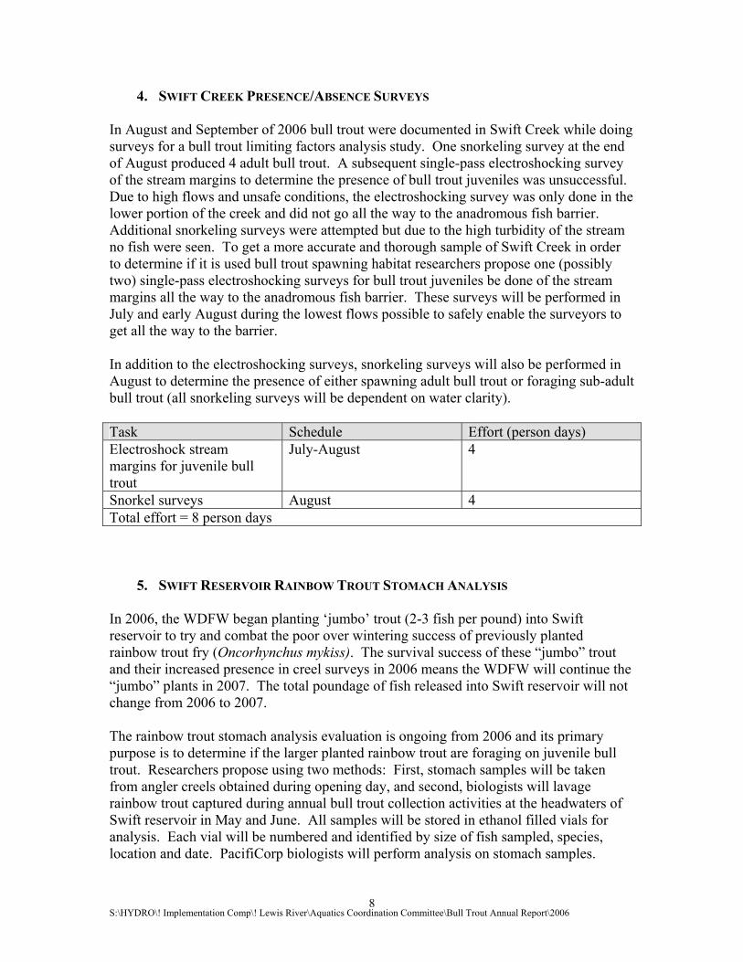
4. SWIFT CREEK PRESENCE/ABSENCE SURVEYS
In August and September of 2006 bull trout were documented in Swift Creek while doing surveys for a bull trout limiting factors analysis study. One snorkeling survey at the end of August produced 4 adult bull trout. A subsequent single-pass electroshocking survey of the stream margins to determine the presence of bull trout juveniles was unsuccessful. Due to high flows and unsafe conditions, the electroshocking survey was only done in the lower portion of the creek and did not go all the way to the anadromous fish barrier. Additional snorkeling surveys were attempted but due to the high turbidity of the stream no fish were seen. To get a more accurate and thorough sample of Swift Creek in order to determine if it is used bull trout spawning habitat researchers propose one (possibly two) single-pass electroshocking surveys for bull trout juveniles be done of the stream margins all the way to the anadromous fish barrier. These surveys will be performed in July and early August during the lowest flows possible to safely enable the surveyors to get all the way to the barrier. In addition to the electroshocking surveys, snorkeling surveys will also be performed in August to determine the presence of either spawning adult bull trout or foraging sub-adult bull trout (all snorkeling surveys will be dependent on water clarity). Task Schedule Effort (person days) Electroshock stream margins for juvenile bull trout
July-August 4
Snorkel surveys August 4 Total effort = 8 person days
5. SWIFT RESERVOIR RAINBOW TROUT STOMACH ANALYSIS In 2006, the WDFW began planting ‘jumbo’ trout (2-3 fish per pound) into Swift reservoir to try and combat the poor over wintering success of previously planted rainbow trout fry (Oncorhynchus mykiss). The survival success of these “jumbo” trout and their increased presence in creel surveys in 2006 means the WDFW will continue the “jumbo” plants in 2007. The total poundage of fish released into Swift reservoir will not change from 2006 to 2007. The rainbow trout stomach analysis evaluation is ongoing from 2006 and its primary purpose is to determine if the larger planted rainbow trout are foraging on juvenile bull trout. Researchers propose using two methods: First, stomach samples will be taken from angler creels obtained during opening day, and second, biologists will lavage rainbow trout captured during annual bull trout collection activities at the headwaters of Swift reservoir in May and June. All samples will be stored in ethanol filled vials for analysis. Each vial will be numbered and identified by size of fish sampled, species, location and date. PacifiCorp biologists will perform analysis on stomach samples.

S:\HYDRO\! Implementation Comp\! Lewis River\Aquatics Coordination Committee\Bull Trout Annual Report\2006
9
Task Schedule Effort (person days) Collection of stomach contents from rainbow trout
April – June 11
Analysis and documentation November 7 Total Effort = 18 person days
6. COUGAR CREEK SPAWNING ESTIMATE Since 1979, PacifiCorp biologists, along with various state and federal agencies, have conducted annual surveys to estimate spawning escapement of kokanee (Oncorhynchus nerka) in Cougar Creek. Along with the kokanee counts, bull trout spawners are also counted, as their spawn time overlaps with that of kokanee. Foot surveys are used to visually count kokanee and bull trout. Surveys are performed by two biologists, each enumerating the number of kokanee and bull trout on one half of the creek. The entire length of Cougar Creek is surveyed – a distance of about 1.5 miles. All bull trout are observed for tags to identify bull trout transported from the Yale tailrace. Bull trout population estimates have ranged from 0 to 40 fish. This variability is due in part to sampling error, but is also indicative of low run size. Results of Cougar Creek kokanee surveys are reported annually and provided to the WDFW. As part of sampling in 2007, to combat the variability between bull trout estimates (weekly foot surveys have a tendency to not see all fish and weekly snorkel surveys have a tendency to cumulatively count fish from prior surveys resulting in one counting too few and the other too many) researchers instead propose weekly bull trout redd counts from September to November. Bull trout will continue to be enumerated where seen, but the surveys will be focused on locating redds. Redds will be mapped using a GPS and flagged until no longer visible to avoid double counts. Along with a more accurate population estimate these surveys should also give a better understanding of preferred spawning habitat within the stream. In addition, four snorkel surveys of Cougar Creek will also be conducted. Additional surveys may be completed by the WDFW. Past snorkel surveys have shown to be helpful in documenting the presence of juvenile and at times adult bull trout. Task Schedule Effort (person days) Preliminary survey to identify and document migration barriers (debris survey)
July 2
Redd surveys of Cougar Creek (weekly) Sep – Nov 24 Snorkel surveys(4) Sep -- Nov 8 Additional surveys if “new redds” are present in the creek.
December 2
Total Effort = 36 person days

S:\HYDRO\! Implementation Comp\! Lewis River\Aquatics Coordination Committee\Bull Trout Annual Report\2006
10
7. SNORKEL SURVEY OF THE SWIFT NO. 2 BYPASS REACH AND SIDE CHANNELS Water discharge from the Swift No. 1 project has been flowing into the bypass reach since May 2002. From 2002 through 2005, this water was shunted over the canal spillway and into the bypass reach. In 2006, the amount of water entering the bypass reach was limited to the amount of water passing through the canal drain and into the constructed channel. The presence of this cold water attracts bull trout (as well as other fish species) into the reach from Yale reservoir. Fish can also enter the bypass from either the canal wasteway or Swift No. 1 spillway. The presence of bull trout and other salmonids and the relative survey ease, make the bypass an ideal area to conduct species composition, abundance and distribution estimates within the reach. Surveys may also be used to provide information on tagged bull trout from the Yale tailrace netting and transportation activities. In 2006, PacifiCorp, along with biologists from the WDFW identified numerous bull trout in the Swift bypass reach and side channels on nine separate snorkel surveys. Other species identified included: spring chinook (Oncorhychus tshawytscha), rainbow trout (Oncorhychus mykiss), cutthroat trout (Oncorhychus clarki), large-scale suckers (Catostomus macrocheilus), sculpins (Cottid spp.), three-spine stickleback (Gasterosteus aculeatus), mountain whitefish (Prosopium williamsoni), kokanee (Oncorhychus nerka) and brook trout (Salvelinus fontinalis) were also observed. The WDFW may conduct additional surveys (than those proposed below) of the reach. PacifiCorp will continue these efforts in 2007 to document fish use in the Swift bypass reach and lower release channel. Snorkel surveys will commence at the lower release channel inlet and continue downstream to the “International Paper” (IP) bridge crossing (Figure 7.0-1).

S:\HYDRO\! Implementation Comp\! Lewis River\Aquatics Coordination Committee\Bull Trout Annual Report\2006
11
Figure 7.0-1: Area map detailing the survey portion of the Swift bypass reach (not including the lower release channel). The primary purpose of these surveys will be to document bull trout presence and distribution in the lower release channel and Swift bypass reaches. At least two single pass electrofishing surveys of the lower release channel and at least one stratified sample single pass electrofishing survey of the bypass reach margins will be conducted for the presence of bull trout juveniles and to obtain a more detailed species composition, abundance, and distribution estimate. Additional electrofishing surveys will occur only if flows are reduced in the lower release channel due to maintenance activities. Task Schedule Effort (person days) Snorkel Survey of bypass reach and lower release channel
August – October 27
Electrofishing Survey of lower release channel and bypass reach margins
July -- August 9
Total Effort = 36 person days
S:\HYDRO\! Implementation Comp\! Lewis River\Aquatics Coordination Committee\Bull Trout Annual Report\2006
12
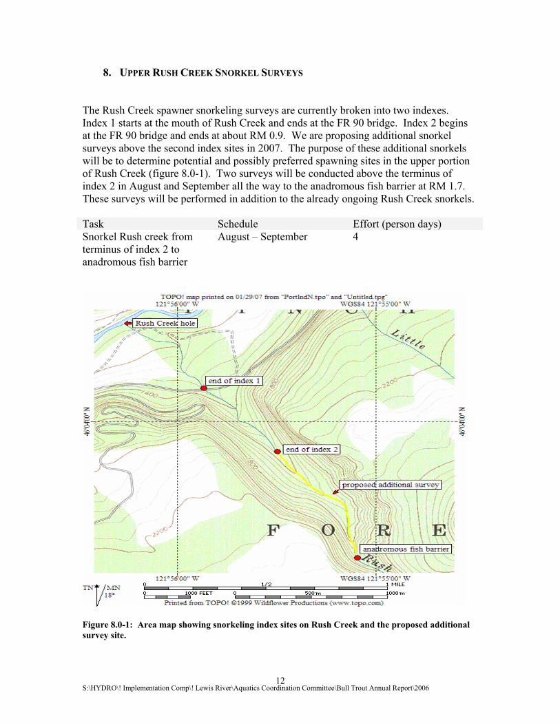
8. UPPER RUSH CREEK SNORKEL SURVEYS
The Rush Creek spawner snorkeling surveys are currently broken into two indexes. Index 1 starts at the mouth of Rush Creek and ends at the FR 90 bridge. Index 2 begins at the FR 90 bridge and ends at about RM 0.9. We are proposing additional snorkel surveys above the second index sites in 2007. The purpose of these additional snorkels will be to determine potential and possibly preferred spawning sites in the upper portion of Rush Creek (figure 8.0-1). Two surveys will be conducted above the terminus of index 2 in August and September all the way to the anadromous fish barrier at RM 1.7. These surveys will be performed in addition to the already ongoing Rush Creek snorkels. Task Schedule Effort (person days) Snorkel Rush creek from terminus of index 2 to anadromous fish barrier
August – September 4
Figure 8.0-1: Area map showing snorkeling index sites on Rush Creek and the proposed additional survey site.

S:\HYDRO\! Implementation Comp\! Lewis River\Aquatics Coordination Committee\Bull Trout Annual Report\2006
13
9. UPPER LEWIS TRIBUTARY SURVEYS During annual Rush Creek snorkel surveys the area called the “Rush Creek Hole” (section of the mainstem Lewis River directly downstream of Rush Creek mouth) has historically and currently held the largest numbers of pre-spawn adult bull trout. It is thought that this is a staging area for adult spawners before they ascend Rush Creek. Lately the assumption that all these fish (at times upwards of 200) go up Rush Creek has been questioned due to the low fish numbers encountered during the Rush Creek mainstem snorkel surveys. There is some snorkel data indicating that a small portion of the bull trout ascend the North Fork Lewis River as far upstream as Lower Falls. Because of this distribution, it is possible that some bull trout are spawing in tributaries other than Rush and Pine Creek. Therefore, we are proposing additional surveys of mainstem tributaries between the confluence of Rush Creek and Lower Falls. PacifiCorp proposes performing single-pass electroshock and snorkel surveys of three Lewis River tributaries above Rush Creek (figure 9.0-1). Knowing that bull trout require cold water allows us to look at historical data to find likely creeks suitable for bull trout spawning. In a draft report prepared by Clearwater BioStudies, Inc. for the USDA Forest Service, GPNF titled Bull Trout Surveys and Stream Temperature Monitoring Conducted within selected watersheds on the Gifford Pinchot National Forest, summer 2001 two streams above Rush Creek fit the temperature criteria, Cussed Hollow Creek and Spencer Creek. Thermographs deployed in these streams show water temperature below 10º C in late September and early October. This time frame is during the peak of bull trout spawning and the water temperature is within the range of the preferred thermal spectrum. In addition to the two above mentioned streams, a third as yet unnamed Lewis River tributary with GPS coordinates 46º 07’ 01’’ North, 121º 55’ 06’’ West will also be surveyed. During past Lewis River mainstem snorkel surveys this stream has raised bull trout spawning habitat speculation given its good flows and low gradient at its mouth. No known temperature data exists for this stream. These three streams will be electroshocked, in late June or early July, to their anadromous fish barriers for the presence of bull trout juveniles and then snorkeled in early October for the presence of adult bull trout. In addition to the surveys, temperature and habitat data will also be recorded. Task Schedule Effort (person days) Electrofishing survey of three Upper Lewis River tributaries.
June – July 6
Snorkel survey of three Upper Lewis River tributaries.
October 6
Total Effort = 12 person days

S:\HYDRO\! Implementation Comp\! Lewis River\Aquatics Coordination Committee\Bull Trout Annual Report\2006
14
Figure 9.0-1: Map of proposed survey sites for bull trout above Rush Creek.

S:\HYDRO\! Implementation Comp\! Lewis River\Aquatics Coordination Committee\Bull Trout Annual Report\2006
15
III REFERENCES Chambers, J.S. 1957. Report on the 1956 survey of the North Fork of the Lewis River above Yale dam. State of Washington, Department of Fisheries. 37 pp Clearwater BioStudies. 2001. Draft report on Bull Trout Surveys and Stream Temperature Monitoring Conducted within Selected Watersheds on the Gifford Pinchot National Forest, Summer 2001. pgs 20-21 AQU 4 Technical Studies Status Reports. Upper Lewis River Anadromous Fish Barriers Survey. 2001