Embed Size (px)
Citation preview
Kootenai River Fisheries Investigations
Rainbow and Bull Trout Recruitment
Annual Report 2002 - 2003 January 2004 DOE/BP-00004691-5
This Document should be cited as follows:
Walters, Jody, "Kootenai River Fisheries Investigations; Rainbow and Bull Trout Recruitment",2002-2003 Annual Report, Project No. 198806500, 51 electronic pages, (BPA Report DOE/BP-00004691-5)
Bonneville Power AdministrationP.O. Box 3621Portland, OR 97208
This report was funded by the Bonneville Power Administration (BPA),U.S. Department of Energy, as part of BPA's program to protect, mitigate,and enhance fish and wildlife affected by the development and operationof hydroelectric facilities on the Columbia River and its tributaries. Theviews in this report are the author's and do not necessarily represent theviews of BPA.

KOOTENAI RIVER FISHERIES INVESTIGATIONS: RAINBOW AND BULL TROUT RECRUITMENT
ANNUAL PROGRESS REPORT April 1, 2002 — March 31, 2003
Prepared by:
Jody P. Walters, Senior Fishery Research Biologist
IDFG Report Number 04-02 January 2004

Kootenai River Fisheries Investigations: Rainbow and Bull Trout Recruitment
Project Progress Report
2002 Annual Report
By
Jody P. Walters Senior Fishery Research Biologist
Idaho Department of Fish and Game 600 South Walnut Street
P.O. Box 25 Boise, ID 83707
To
U.S. Department of Energy Bonneville Power Administration
Division of Fish and Wildlife P.O. Box 3621
Portland, OR 97283-3621
Project Number 1988-06500 Contract Number 00004691
IDFG Report Number 04-02 January 2004
i
TABLE OF CONTENTS Page
ABSTRACT................................................................................................................................... 1 INTRODUCTION .......................................................................................................................... 2 GOALS.......................................................................................................................................... 3 OBJECTIVES................................................................................................................................ 3 STUDY AREA ............................................................................................................................... 4 METHODS .................................................................................................................................... 5
Rainbow Trout Recruitment....................................................................................................... 5 Rainbow and Bull Trout Spawning Tributary Identification and Migration Timing ..................... 7 Bull Trout Redd Surveys ........................................................................................................... 8 Rainbow Trout Population Size Structure.................................................................................. 8
RESULTS ..................................................................................................................................... 9 Rainbow Trout Recruitment....................................................................................................... 9
Assessment of Moving Trout Upstream of Culverts............................................................... 9 Spawning Channel Feasibility.............................................................................................. 10 Recruitment from Boulder Creek and the Moyie River ........................................................ 10 Deep Creek Water Temperatures........................................................................................ 11
Rainbow and Bull Trout Spawning Tributary Identification and Migration Timing ................... 11 Rainbow Trout...................................................................................................................... 11 Bull Trout.............................................................................................................................. 12
Bull Trout Redd Surveys ......................................................................................................... 13 Rainbow Trout Population Size Structure................................................................................ 15
DISCUSSION.............................................................................................................................. 15 RECOMMENDATIONS............................................................................................................... 17 ACKNOWLEDGEMENTS ........................................................................................................... 18 LITERATURE CITED.................................................................................................................. 19 APPENDICES............................................................................................................................. 22
LIST OF TABLES Table 1. Locations of temperature data loggers in the Deep Creek drainage, 2002.
The GPS coordinates are for zone 11, and the datum = WGS84. ............................. 6
Table 2. Approximate transmitter weights, duty cycles, and life expectancies for radio transmitters implanted into rainbow and bull trout in the Kootenai River, Idaho 2002. ................................................................................................................ 8
Table 3. Chronology of weir and electrofishing sampling on Caboose Creek, spring 2002. Rbt = rainbow trout, Rbt X Wct = rainbow and westslope cutthroat trout hybrid, Unk = unknown, M = male. .................................................................... 9
ii
List of Tables, continued. Page
Table 4. Survey dates, water temperatures and numbers of trout redds seen on
Caboose and Debt creeks, spring 2002..................................................................... 9
Table 5. Summary of water temperature data for the four Deep Creek temperature logger sites downstream of McArthur Reservoir. ..................................................... 11
Table 6. Summary of first recorded movements during spawning seasons and first recorded locations in tributary streams for radio-tagged trout, 2002. Bullt = bull trout, Rbt = rainbow trout, Wct = westslope cutthroat trout. ................... 12
Table 7. Streams surveyed for bull trout redds and numbers of bull trout and kokanee redds found, fall 2002............................................................................................... 14
LIST OF FIGURES Figure 1. The Kootenai River drainage: “d” is Debt Creek and “c” is Caboose Creek. ............. 5
Figure 2. Water temperature monitoring sites in the Deep Creek drainage. ............................. 7
Figure 3. Elevation differences between the proposed spawning channel inlet and outlet sites on the Moyie River, spring and summer 2002. ...................................... 10
Figure 4. Kootenai River discharge (m3/s) at Leonia, March 1 through August 31, 2002 (data from U.S. Army Corps of Engineers). ............................................................. 13
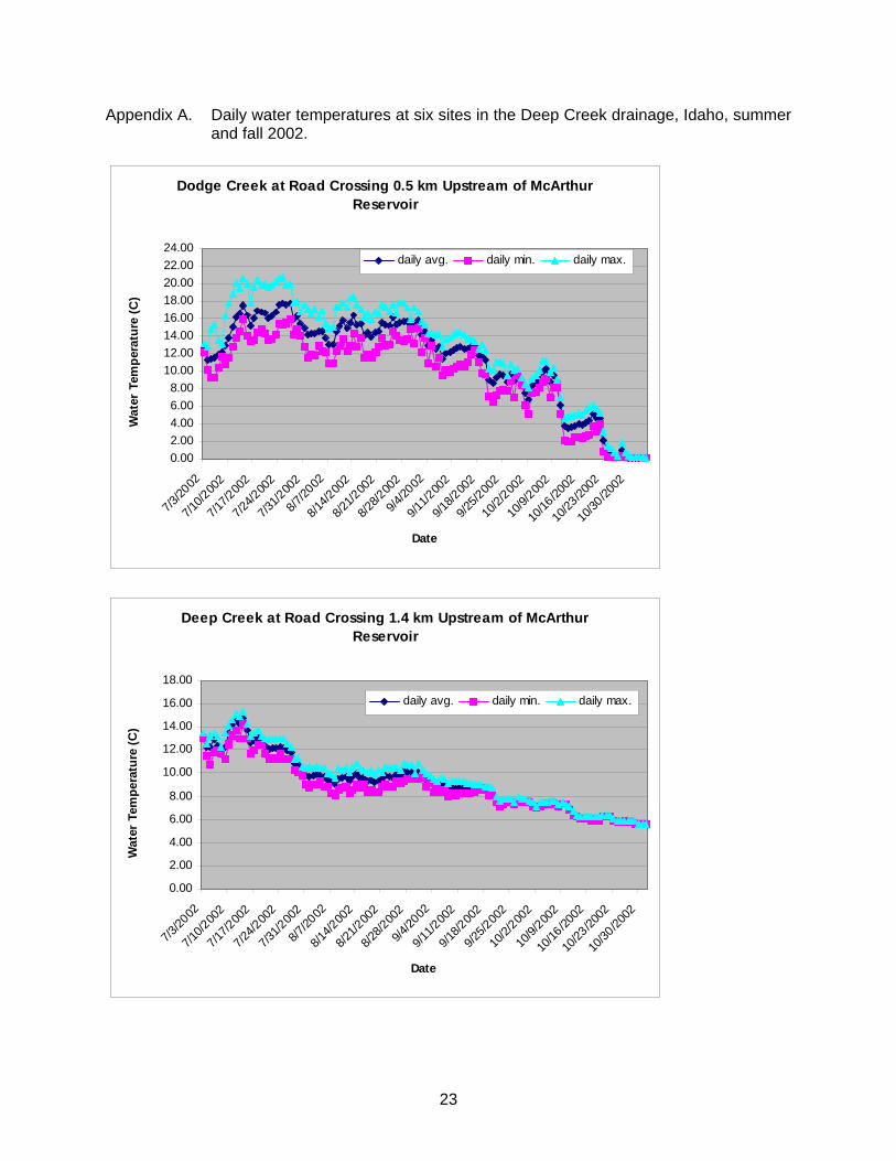
LIST OF APPENDICES Appendix A. Daily water temperatures at six sites in the Deep Creek drainage, Idaho,
summer and fall 2002.......................................................................................... 23
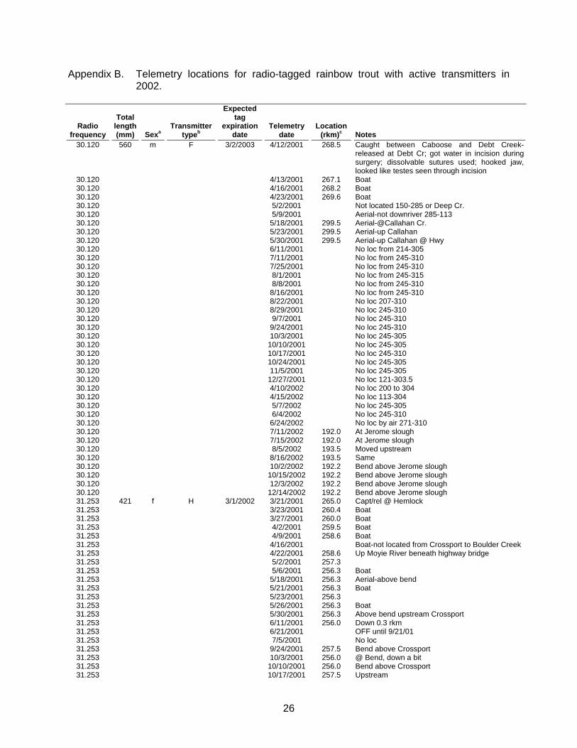
Appendix B. Telemetry locations for radio-tagged rainbow trout with active transmitters in 2002................................................................................................................. 26
Appendix C. Telemetry locations for radio-tagged bull trout with active transmitters in 2002. ................................................................................................................... 36

1
ABSTRACT
Rainbow trout Oncorhynchus mykiss provide the most important sport fishery in the Kootenai River, Idaho, but densities and catch rates are low. Low recruitment is one possible factor limiting the rainbow trout population. Bull trout Salvelinus confluentus also exist in the Kootenai River, but little is known about this population. Research reported here addresses the following objectives for the Kootenai River, Idaho: increase rainbow trout recruitment, identify rainbow and bull trout spawning tributaries and migration timing, establish baseline data on bull trout redd numbers in tributaries, and improve the rainbow trout population size structure. Six adult rainbow trout were moved to spawning habitat upstream of a potential migration barrier on Caboose Creek, but numbers of redds and age-0 out-migrants did not appear to increase relative to a reference stream. Measurements taken on the Moyie River indicated the gradient is inadequate to deliver suitable flows to a proposed rainbow trout spawning channel. Summer water temperatures measured in the Deep Creek drainage sometimes exceeded 24°C, higher than those reported as suitable for rainbow trout. Radio-tagged rainbow trout were located in Boulder Creek during the spring spawning season, and bull trout were located in the Moyie River and O’Brien Creek, Montana in the fall. Bull trout spawning migration timing was related to increases in Kootenai River flows. Bull trout redd surveys documented 19 redds on Boulder Creek and North and South Callahan creeks. Fall 2002 electrofishing showed that the Kootenai River rainbow trout proportional stock density was 54, higher than prior years when more liberal fishing regulations were in effect. Boulder Creek produces the highest number of age-0 rainbow trout out-migrants upstream of Bonners Ferry, but the survival rate of these out-migrants upon reaching the Kootenai River is unknown. Determining juvenile survival rates and sources of mortality could aid management efforts to increase rainbow trout recruitment. North and South Callahan creeks support the largest spawning population of bull trout in the Kootenai River drainage, Idaho, so management of the watershed should consider bull trout as high priority.
Author: Jody P. Walters Senior Fishery Research Biologist

2
INTRODUCTION
The Kootenai River in Idaho has recently lost fisheries for several species including white sturgeon Acipenser transmontanus, burbot Lota lota, and kokanee Oncorhynchus nerka (Richards 1997). The mountain whitefish Prosopium williamsoni population has also declined since the early 1980s (Partridge 1983; Paragamian 1995a, 1995b; Downs 2000; Walters and Downs 2001). Although no rainbow O. mykiss or westslope cutthroat trout O. clarki lewisi population data exist prior to 1980, these populations also appear depressed based on catch rates. Angler catch rates of trout (rainbow and westslope cutthroat) for the Kootenai River, Idaho were 0.06, 0.03, 0.21, and 0.14 fish/h in 1982, 1993, 2001, and 2002, respectively (Partridge 1983; Paragamian 1995a; Walters 2003; Idaho Department of Fish and Game [IDFG] unpublished data). These rates are low when compared to the Kootenai River, Montana where trout catch rates of 0.36 to 0.48 fish/h were reported for 1978 and 1979, respectively, the most recent year-round creel data for Montana (May and Houston 1979).
The rainbow trout density in the Idaho reach of the Kootenai River is an order of
magnitude lower than in the Flower-Pipe reach of Montana. The average age-2 and older density in the Flower-Pipe reach was 662 trout/km for 1993, 1994, and 1999, while the density at the Hemlock Bar reach in Idaho for the same years averaged 47 trout/km (5 trout/ha and standing stock of 1.3 kg/ha) (Paragamian 1995a, 1995b; Downs 2000; Walters and Downs 2001; J. Dunnigan, MFWP, personal communication). Lower densities likely contribute to the lower angler catch rates in Idaho. Despite low densities and catch rates, rainbow trout provide the most important fishery in the Kootenai River, Idaho (Paragamian 1995a).
The low rainbow trout densities in Idaho are hypothesized to result from limited juvenile
recruitment to the Kootenai River mainstem (Partridge 1983; Fredericks and Hendricks 1997). The Deep Creek drainage produces about 40,000 rainbow trout juvenile out-migrants to the Kootenai River annually, more than the rest of the Idaho tributaries combined (Downs 1999, 2000; Walters and Downs 2001; Walters 2002, 2003). However, juvenile rearing densities in the Deep Creek mainstem are low (7.8 fish/100 m2) relative to high densities (up to 109 fish/100 m2) in several Deep Creek tributaries (Fredericks and Hendricks 1997). High summer water temperatures were suggested as one factor limiting juvenile rearing densities in the Deep Creek mainstem (Fredericks and Hendricks 1997). Water temperature data are still lacking for the drainage.
Rainbow trout recruitment from tributaries upstream of Deep Creek is low, with an
estimated maximum of about 15,000 juvenile (mainly age-0) recruits to the Kootenai River annually (Walters 2002, 2003; IDFG unpublished data). The majority of this recruitment is from Boulder Creek (Walters 2002, 2003), though Partridge (1983) stated that this stream has poor spawning conditions due to large substrates and embedded gravels. Boulder Creek also has a waterfall barrier, restricting fluvial trout to the lower 2 km of the stream. Caboose and Debt creeks produce age-0 recruits, but culverts on these streams may prevent some rainbow trout adults from reaching spawning habitat upstream (Partridge 1983; IDFG unpublished data). These streams also flow subsurface through alluvial fans by July, preventing age-0 rainbow trout from out-migrating (Walters 2003). The Moyie River is the largest Idaho tributary upstream of Bonners Ferry, but spawning habitat is limited due to large substrates and an upstream barrier (dam and natural falls) 2 km from the mouth (Partridge 1983). Partridge (1983) also noted that the main gravel bar was channelized by a landowner to prevent bank erosion. Increasing access to, or enhancing rainbow trout spawning and rearing habitat in, these tributaries may increase recruitment to the Kootenai River.

3
Additional trout recruitment to the Kootenai River, Idaho from Montana is likely (Downs
2000; Walters and Downs 2001; Walters 2003). Although juvenile out-migration from Montana tributaries has not been investigated, rainbow and bull trout radio-tagged in the Kootenai River, Idaho have been tracked to Montana tributaries during the spawning season (Walters and Downs 2001; Walters 2003). An increased sample size of radio-tagged trout may identify more Idaho and Montana spawning tributaries. Identification of spawning tributaries will help prioritize streams for habitat protection or enhancement.
Changes in Kootenai River flows and temperature are known to affect Kootenai River
white sturgeon and burbot spawning migration timing (Paragamian 2000; Paragamian and Kruse 2001), but effects on rainbow and bull trout are unknown. If the altered hydrograph and change in water temperatures due to operations of Libby Dam negatively affect trout migration timing, this could also affect recruitment. More data are needed regarding the timing of trout spawning migrations in relation to flow and temperature.
Another possible factor limiting the Kootenai River rainbow trout population is angling
exploitation. Annual exploitation rates of 58% and 46% were documented for 1999 and 2000, respectively (Walters and Downs 2001; Walters 2002). In response to these exploitation rates, more conservative regulations were initiated for the trout fishery. Beginning January 1, 2002, a 16” (406 mm) minimum length limit and two-fish bag limit was established for rainbow and westslope cutthroat trout in the Kootenai River, Idaho. The regulations through 2001 included no size limit and a six-fish bag limit for trout. The goals of the new regulations are to conserve the trout population for continued fishing opportunities, improve the population size structure, and increase trout densities by decreasing angler exploitation and protecting trout until they can spawn at least once. Continued monitoring of the trout population is necessary to evaluate the effects of the new regulations.
Bull trout in the Columbia River basin were listed in the Federal Register as a threatened
species under the Endangered Species Act on June 10, 1998. Little is known about bull trout in the Kootenai River in Idaho. Tributary surveys have documented few bull trout, while about two/yr are caught during mainstem sampling (Partridge 1983; Paragamian 1995a, 1995b; Walters and Downs 2001; Walters 2002). More baseline information regarding bull trout spawning locations and recruitment sources is important to documenting recovery needs of this population.
GOALS
1. Provide a management plan to improve the rainbow trout fishery. 2. Achieve bull trout recovery targets for the lower Kootenai River as addressed in the draft
bull trout recovery plan (U.S. Fish and Wildlife Service 2002).
OBJECTIVES
1. Increase rainbow trout recruitment to the Kootenai River, Idaho. 2. Identify rainbow and bull trout spawning tributaries
4
3. Collect baseline data on rainbow and bull trout spawning migration timing relative to Kootenai River flows and temperatures.
4. Collect baseline data on numbers of bull trout redds in Kootenai River tributaries in
Idaho. 5. Improve the rainbow trout population size structure.
STUDY AREA
The Kootenai River (spelled Kootenay in Canada) flows south out of British Columbia into Montana, northwest into Idaho, then north back into British Columbia and Kootenay Lake (Figure 1). It flows out of the west arm of Kootenay Lake and enters the Columbia River at Castlegar, British Columbia. In the U.S., the Kootenai River is regulated by Libby Dam in Montana (Figure 1). There are approximately 105 km of Kootenai River in Idaho with the following three reaches: 1) the Canyon Reach (22 km) from the Montana border to the Moyie River, 2) the Braided Reach (10 km) from the Moyie River to Bonners Ferry, and 3) the Meandering Reach (73 km) from Bonners Ferry to the Canadian border (Fredericks and Hendricks 1997). The Meandering Reach has a relatively slow velocity and substrates consisting mainly of sand, silt, and clays (Partridge 1983). Dikes on either side of the river in this reach prevent flooding of the adjacent agricultural lands. The Braided and Canyon reaches upstream of Bonners Ferry appear more suitable for fluvial rainbow trout with riffles, runs, and pools, and gravel and cobble substrates. Work in 2002 occurred mainly in the Canyon Reach including the tributaries of Boulder, Caboose, Curley, and Debt creeks and the Moyie River. Sampling was also conducted in the Callahan and Deep creek drainages (Figure 1).
The Kootenai River in Montana upstream to Kootenai Falls is also accessible to fluvial
and adfluvial trout. Kootenai Falls at river kilometer (rkm) 310 was a presumed migration barrier to upstream fish movement (Chapman and May 1986), but one bull trout has been documented moving upstream past the falls (M. Hensler, Montana Fish, Wildlife and Parks, personal communication). Major tributaries in Montana downstream of Kootenai Falls include O’Brien and Callahan creeks (Figure 1).

5
KoocanusaReservoir
Libby DamKootenai
Falls
MoyieRiver
DeepCreek
BonnersFerry
Creston
Nelson
KootenayLake
N0 50
Kilometers
BRITISH COLUMBIA
MONTANAWASHINGTON IDAHO
TroyCallahan
Creek
Kootenay River
Kootenai River
Kootenai River
Kootenay River
To Columbia River
O’Brien Creek
Boulder Creek
Curley Creek
dc
Figure 1. The Kootenai River drainage: “d” is Debt Creek and “c” is Caboose Creek.
METHODS
Rainbow Trout Recruitment
Several tasks were initiated to increase rainbow trout recruitment, determine feasibility for increasing recruitment, and measure recruitment. A weir was placed on Caboose Creek between the mouth and the railroad crossing culverts (two side-by-side culverts) upstream in order to trap rainbow trout ascending the creek to spawn. Because the railroad culverts are a possible upstream migration barrier (Partridge 1983, IDFG unpublished data), rainbow trout trapped at the weir were placed upstream of the culverts where they would have access to more spawning habitat. The weir was installed on April 25 and removed on June 25. Weir construction consisted of a conduit picket fence angled downstream with upstream and downstream trap boxes. All captured rainbow trout were measured (nearest mm total length [TL]) and weighed. If length was ≥120 mm TL (estimated to be ≥age-2), they were checked for evidence of sex, given a fin clip mark corresponding to the trap box in which they were caught, and then released upstream of the culverts if caught in the upstream trap box or downstream of

6
the weir if caught in the downstream trap box. Because the weir was breached by high water in May, a backpack electrofisher was also used to sample the plunge pool below the culverts for rainbow trout. These trout were also marked with a fin clip and released upstream of the culverts.
Rainbow trout redd surveys were conducted on Caboose and Debt creeks in May and
June 2002. Streams were walked during midday from the mouth up to the first migration barrier upstream of the railroad culverts, distances of about 240 m on Caboose Creek and 600 m on Debt Creek. Disturbed gravel or cobble areas showing a pit and tailspill (Grost et al. 1991) were identified as rainbow trout redds. The redd surveys were conducted as one means of comparing potential rainbow trout production in Caboose Creek (treatment stream) versus Debt Creek (reference stream). Debt Creek was chosen as a reference because it was the most similar to Caboose Creek in terms of discharge, water temperatures, substrates, and aspect and size of the drainage (IDFG unpublished data). Debt Creek also has railroad culverts that are a possible upstream migration barrier (Partridge 1983, IDFG unpublished data).
Passive drift net sampling (Muth and Schmulbach 1984) was conducted on Caboose
and Debt creeks to estimate the number of age-0 rainbow trout out-migrants (recruits to the Kootenai River) in summer as an index of relative production in the two streams. Drift net sampling occurred from June 25 through August 8. Drift net sampling methods and calculations of out-migrant estimates and confidence intervals were the same as described in Walters (2003).
In 2001, a feasibility study was done to determine if a spawning channel could be built
on the lower Moyie River to increase rainbow trout recruitment to the Kootenai River (Walters 2003). The study determined that more Moyie River elevation measurements were needed during the rainbow trout spawning and egg incubation period. These measurements were made in 2002 using a transit level to measure difference in river elevation between the proposed spawning channel inlet and outlet. Measurements were taken approximately once/wk from March 27 through August 1. Drift net sampling to estimate the number of age-0 rainbow trout out-migrants was conducted from July 15 through August 8 on the Moyie River downstream of the proposed spawning channel site, and from June 25 through August 8 on Boulder Creek. This sampling was conducted to collect pretreatment data on numbers of age-0 rainbow trout out-migrants should the spawning channel be built. Boulder Creek is similar in terms of discharge and geomorphology, so it was chosen as a reference stream to compare to the Moyie River.
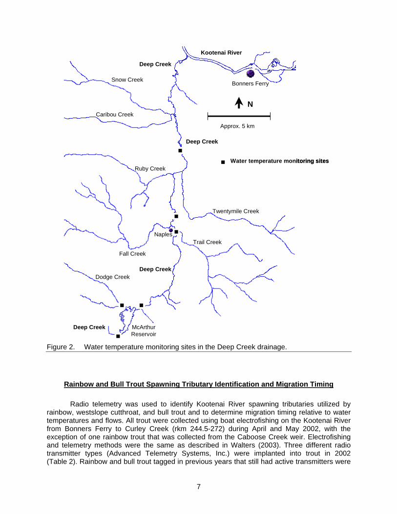
Optic StowAway® temperature data loggers were used to record summer and fall water
temperatures every 4 h at six sites in the Deep Creek drainage. These sites were upstream and downstream of McArthur Lake (Table 1; Figure 2).
Table 1. Locations of temperature data loggers in the Deep Creek drainage, 2002. The GPS coordinates are for zone 11, and the datum = WGS84.
GPS coordinates Stream Launch Date Pull Date Eastings Northings Location description Dodge Cr. 7/3/02 11/4/02 539900 5374586 Road Crossing 0.5 km upstream of McArthur Reservoir Deep Cr. 7/3/02 11/1/02 539012 5371555 Road Crossing 1.4 km upstream of McArthur Reservoir Deep Cr. 6/17/02 11/4/02 541600 5374478 0.5 km downstream of McArthur Reservoir Deep Cr. 7/3/02 11/4/02 544711 5379296 Highway 95 bridge at Naples Deep Cr. 7/3/02 11/1/02 544175 5382510 2nd bridge crossing on old Highway 95 north of Naples Deep Cr. 7/3/02 11/1/02 545173 5386521 1st bridge north of the Deep Creek Inn
7
Kootenai River
McArthur Reservoir
Dodge Creek
Deep Creek
Deep Creek
Water temperature monitoring sites
Trail Creek
Twentymile Creek
Fall Creek
Ruby Creek
Caribou Creek
Snow Creek
Deep Creek
N
Naples
Bonners Ferry
Approx. 5 km
Deep Creek
Kootenai River
McArthur Reservoir
Dodge Creek
Deep Creek
Deep Creek
Water temperature monitoring sites
Trail Creek
Twentymile Creek
Fall Creek
Ruby Creek
Caribou Creek
Snow Creek
Deep Creek
N
Naples
Bonners Ferry
Approx. 5 km
Deep Creek
Figure 2. Water temperature monitoring sites in the Deep Creek drainage.
Rainbow and Bull Trout Spawning Tributary Identification and Migration Timing
Radio telemetry was used to identify Kootenai River spawning tributaries utilized by rainbow, westslope cutthroat, and bull trout and to determine migration timing relative to water temperatures and flows. All trout were collected using boat electrofishing on the Kootenai River from Bonners Ferry to Curley Creek (rkm 244.5-272) during April and May 2002, with the exception of one rainbow trout that was collected from the Caboose Creek weir. Electrofishing and telemetry methods were the same as described in Walters (2003). Three different radio transmitter types (Advanced Telemetry Systems, Inc.) were implanted into trout in 2002 (Table 2). Rainbow and bull trout tagged in previous years that still had active transmitters were

8
also monitored in 2002 (Walters and Downs 2001; Walters 2002; Walters 2003). The rainbow trout spawning season (including migration to and from spawning tributaries) was defined as March 1-June 30. The bull trout spawning migration period was defined as June 1-October 30. Table 2. Approximate transmitter weights, duty cycles, and life expectancies for radio
transmitters implanted into rainbow and bull trout in the Kootenai River, Idaho 2002.
Approximate transmitter weight (g) Duty cycle Life expectancy (d)
7.7 90 d on, 90 d off, on ~ 160 d 250 10.4 On every day 390 20.2 On every day 690
Bull Trout Redd Surveys
Bull trout redd surveys were conducted on Boulder, Curley, North Callahan, and South Callahan creeks and the Moyie River. Stream transects were hiked during midday to search for redds and spawning adults. Disturbed gravel or cobble areas showing a pit and tailspill were identified as bull trout redds (Shepard and Graham 1983; Dunham et al. 2001). Incidental sightings of kokanee and kokanee redds were also recorded. Kokanee redds were identified based on the presence of kokanee and the smaller substrates, which were mainly sand to pea-size gravel in size.
Rainbow Trout Population Size Structure
In fall 2002, electrofishing was used to sample the rainbow trout population size structure in relation to the new regulations. Rainbow trout were sampled while shocking along the riverbanks from Cow Creek (rkm 250) to Curley Creek (rkm 272). The rainbow trout were measured, weighed, and released. Rainbow trout catch-per-unit-effort, relative weights (Wr), proportional stock density (PSD), and quality stock density (QSD) were then calculated (Anderson 1976; Wege and Anderson 1978; Anderson and Neumann 1996). Relative weights were calculated for rainbow trout size groups of 201-305 mm TL, 306-406 mm TL, and >406 mm TL using the standard weight (Ws) equation for lotic rainbow trout populations proposed by Simpkins and Hubert (1996). Proportional and quality stock densities were calculated for rainbow trout >305 mm TL and >406 mm TL, respectively, using 200 mm TL as stock length (Schill 1991). A 95% confidence interval was estimated for the PSD using the table provided by Gustafson (1988), but equations were not available to estimate the confidence interval for the QSD.
9
RESULTS
Rainbow Trout Recruitment
Assessment of Moving Trout Upstream of Culverts
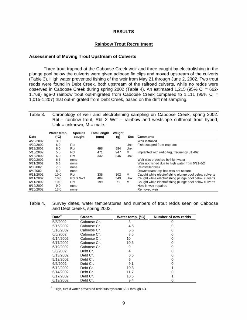
Three trout trapped at the Caboose Creek weir and three caught by electrofishing in the plunge pool below the culverts were given adipose fin clips and moved upstream of the culverts (Table 3). High water prevented fishing of the weir from May 21 through June 2, 2002. Two trout redds were found in Debt Creek, both upstream of the railroad culverts, while no redds were observed in Caboose Creek during spring 2002 (Table 4). An estimated 1,215 (95% CI = 662-1,768) age-0 rainbow trout out-migrated from Caboose Creek compared to 1,111 (95% CI = 1,015-1,207) that out-migrated from Debt Creek, based on the drift net sampling.
Table 3. Chronology of weir and electrofishing sampling on Caboose Creek, spring 2002. Rbt = rainbow trout, Rbt X Wct = rainbow and westslope cutthroat trout hybrid, Unk = unknown, M = male.
Date Water temp.
(°C) Species caught
Total length (mm)
Weight (g) Sex Comments
4/25/2002 3.0 Weir installed 4/30/2002 6.0 Rbt Unk Fish escaped from trap box 5/12/2002 6.0 Rbt 496 984 Unk 5/13/2002 5.5 Rbt 471 947 M Implanted with radio tag, frequency 31.462 5/16/2002 6.0 Rbt 332 346 Unk 5/20/2002 6.5 none Weir was breeched by high water 5/21/2002 5.5 none Weir not fished due to high water from 5/21-6/2 6/3/2002 7.5 none Reinstalled weir 6/4/2002 8.0 none Downstream trap box was not secure 6/11/2002 10.0 Rbt 338 302 M Caught while electrofishing plunge pool below culverts 6/11/2002 10.0 Rbt X Wct 404 549 Unk Caught while electrofishing plunge pool below culverts 6/11/2002 10.0 Rbt 199 71 M Caught while electrofishing plunge pool below culverts 6/12/2002 9.0 none Hole in weir-repaired 6/25/2002 13.0 none Removed weir Table 4. Survey dates, water temperatures and numbers of trout redds seen on Caboose
and Debt creeks, spring 2002.
Datea Stream Water temp. (°C) Number of new redds 5/8/2002 Caboose Cr. 3 0 5/15/2002 Caboose Cr. 4.5 0 5/18/2002 Caboose Cr. 5.6 0 6/5/2002 Caboose Cr. 8.5 0 6/14/2002 Caboose Cr. 10 0 6/17/2002 Caboose Cr. 10.3 0 6/19/2002 Caboose Cr. 9 0 5/8/2002 Debt Cr. 4 0 5/13/2002 Debt Cr. 6.5 0 5/18/2002 Debt Cr. 6 0 6/5/2002 Debt Cr. 9.1 0 6/12/2002 Debt Cr. 10.3 1 6/14/2002 Debt Cr. 11.7 0 6/17/2002 Debt Cr. 10.5 1 6/19/2002 Debt Cr. 9.4 0
a High, turbid water prevented redd surveys from 5/21 through 6/4
10
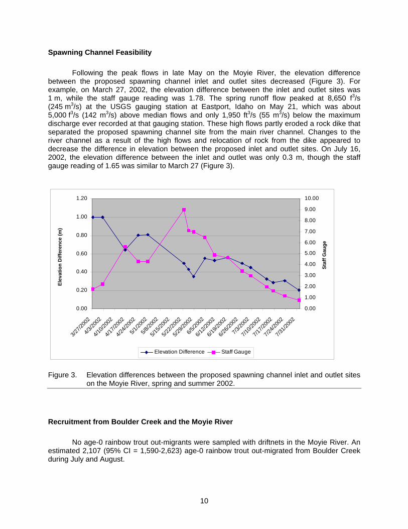
Spawning Channel Feasibility
Following the peak flows in late May on the Moyie River, the elevation difference between the proposed spawning channel inlet and outlet sites decreased (Figure 3). For example, on March 27, 2002, the elevation difference between the inlet and outlet sites was 1 m, while the staff gauge reading was 1.78. The spring runoff flow peaked at 8,650 f3/s (245 m3/s) at the USGS gauging station at Eastport, Idaho on May 21, which was about 5,000 f3/s (142 m3/s) above median flows and only 1,950 ft3/s (55 m3/s) below the maximum discharge ever recorded at that gauging station. These high flows partly eroded a rock dike that separated the proposed spawning channel site from the main river channel. Changes to the river channel as a result of the high flows and relocation of rock from the dike appeared to decrease the difference in elevation between the proposed inlet and outlet sites. On July 16, 2002, the elevation difference between the inlet and outlet was only 0.3 m, though the staff gauge reading of 1.65 was similar to March 27 (Figure 3).
0.00
0.20
0.40
0.60
0.80
1.00
1.20
3/27/2
002
4/3/20
02
4/10/2
002
4/17/2
002
4/24/2
002
5/1/20
02
5/8/20
02
5/15/2
002
5/22/2
002
5/29/2
002
6/5/20
02
6/12/2
002
6/19/2
002
6/26/2
002
7/3/20
02
7/10/2
002
7/17/2
002
7/24/2
002
7/31/2
002
Elev
atio
n D
iffer
ence
(m)
0.00
1.00
2.00
3.00
4.00
5.00
6.00
7.00
8.00
9.00
10.00
Staf
f Gau
ge
Elevation Difference Staff Gauge
Figure 3. Elevation differences between the proposed spawning channel inlet and outlet sites
on the Moyie River, spring and summer 2002.
Recruitment from Boulder Creek and the Moyie River
No age-0 rainbow trout out-migrants were sampled with driftnets in the Moyie River. An estimated 2,107 (95% CI = 1,590-2,623) age-0 rainbow trout out-migrated from Boulder Creek during July and August.

11
Deep Creek Water Temperatures
Maximum daily water temperatures were ≥24°C on several occasions at all four Deep Creek sites downstream of McArthur Lake, while daily average temperatures exceeded 22°C at three of the four sites (Appendix A, Table 5). Average daily water temperatures remained below 20°C on the two tributaries upstream of McArthur Reservoir (Appendix A).
Table 5. Summary of water temperature data for the four Deep Creek temperature logger sites downstream of McArthur Reservoir.
Site
Number of days avg. temp was ≥22°C
Number of days avg. temp was ≥24°C
Number of days max. temp was ≥24°C
Number of days min. temp was ≥22°C
Maximum temp °C
Downstream of McArthur Dam 11 1 8 2 25.1 Hwy 95 bridge at Naples 2 0 3 0 24.5 Approx. 2.5 km downstream of Naples 1 0 5 0 24.4 Approx. 1.4 km downstream of the Deep Cr. Inn 1 0 11 0 25.2
Rainbow and Bull Trout Spawning Tributary Identification and Migration Timing
Rainbow Trout
Eleven radio-tagged rainbow trout were monitored during the spring 2002 spawning season, including nine tagged in 2002 and two tagged in 2001. One westslope cutthroat trout was also radio-tagged in 2002 and monitored during the spawning season (Appendix B). Seven of the rainbow trout and the single westslope cutthroat trout showed movements during the spawning season (Table 6). Five of these trout were located in tributary streams, including three rainbow and one westslope cutthroat trout in Boulder Creek and a rainbow trout in Caboose Creek (Table 6). The rainbow trout in Caboose Creek was caught at the weir, radio-tagged (radio frequency 31.462), and released 50 m upstream of the culverts on May 13 (Table 3). This fish was located either in the plunge pool below the culverts or in the Kootenai River at the mouth of Caboose Creek on several subsequent dates through June 6, but was never located upstream of the culverts. Radio contact with 31.462 was lost after June 6. One rainbow trout (31.643), tagged near Bonners Ferry at rkm 244.5, was located in Kootenay Lake, British Columbia on July 3, after radio contact had been lost since locating the fish at rkm 272.6 (near Curley Creek) on May 23. An angler harvested this fish from Kootenay Lake at rkm 75 in August 2002. Radio contact was also lost with another rainbow trout (31.624) after it was located in Montana at rkm 282.1 (about 6 km upstream of the Idaho-Montana border) on May 18. Another rainbow trout (31.662) moved upstream from rkm 270.6 to rkm 293 in March and as far as rkm 299.5 (Troy, Montana) by April, but this fish was never documented in a tributary stream.
No obvious relationship was observed between rainbow trout spawning movement and
either Kootenai River water temperature or discharge (Table 6, Figure 4). However, three of the four rainbow trout and the single westslope cutthroat trout were first located in tributary streams when the tributary temperatures were near 6°C (Table 6).
12
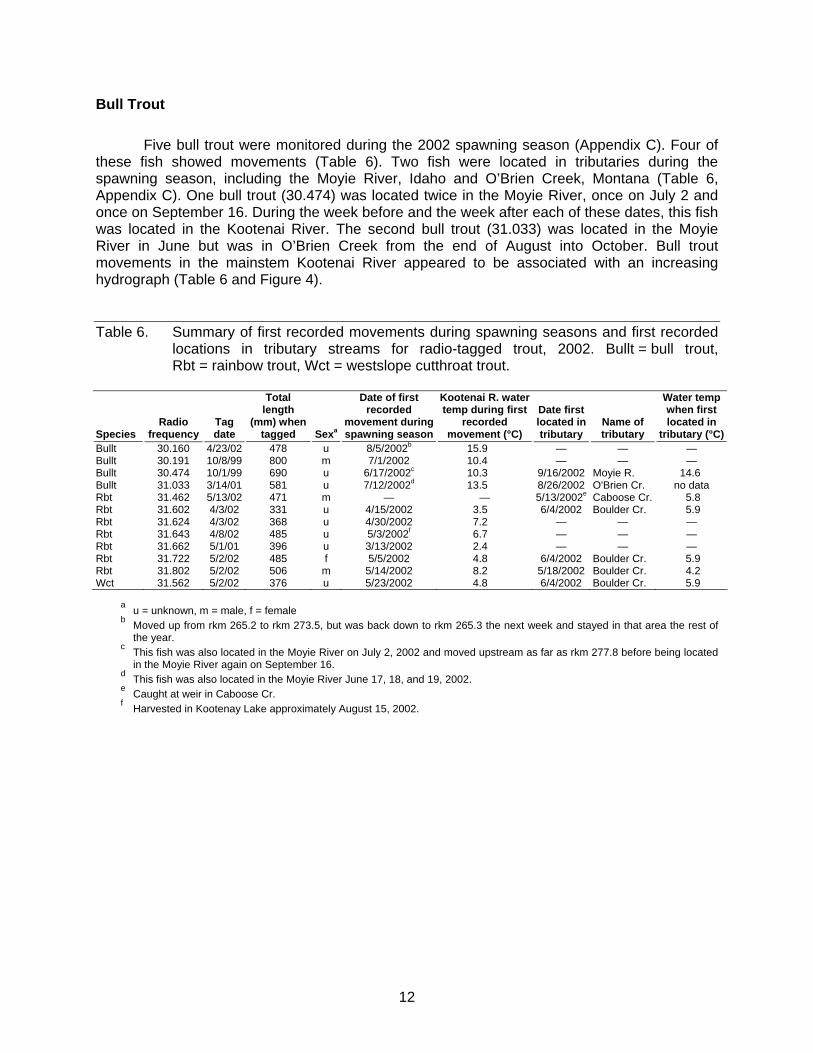
Bull Trout
Five bull trout were monitored during the 2002 spawning season (Appendix C). Four of these fish showed movements (Table 6). Two fish were located in tributaries during the spawning season, including the Moyie River, Idaho and O’Brien Creek, Montana (Table 6, Appendix C). One bull trout (30.474) was located twice in the Moyie River, once on July 2 and once on September 16. During the week before and the week after each of these dates, this fish was located in the Kootenai River. The second bull trout (31.033) was located in the Moyie River in June but was in O’Brien Creek from the end of August into October. Bull trout movements in the mainstem Kootenai River appeared to be associated with an increasing hydrograph (Table 6 and Figure 4).
Table 6. Summary of first recorded movements during spawning seasons and first recorded locations in tributary streams for radio-tagged trout, 2002. Bullt = bull trout, Rbt = rainbow trout, Wct = westslope cutthroat trout.
Species Radio
frequency Tag date
Total length
(mm) when tagged Sexa
Date of first recorded
movement during spawning season
Kootenai R. water temp during first
recorded movement (°C)
Date first located in tributary
Name of tributary
Water temp when first located in
tributary (°C)Bullt 30.160 4/23/02 478 u 8/5/2002b 15.9 — — — Bullt 30.191 10/8/99 800 m 7/1/2002 10.4 — — — Bullt 30.474 10/1/99 690 u 6/17/2002c 10.3 9/16/2002 Moyie R. 14.6 Bullt 31.033 3/14/01 581 u 7/12/2002d 13.5 8/26/2002 O'Brien Cr. no data Rbt 31.462 5/13/02 471 m — — 5/13/2002e Caboose Cr. 5.8 Rbt 31.602 4/3/02 331 u 4/15/2002 3.5 6/4/2002 Boulder Cr. 5.9 Rbt 31.624 4/3/02 368 u 4/30/2002 7.2 — — — Rbt 31.643 4/8/02 485 u 5/3/2002f 6.7 — — — Rbt 31.662 5/1/01 396 u 3/13/2002 2.4 — — — Rbt 31.722 5/2/02 485 f 5/5/2002 4.8 6/4/2002 Boulder Cr. 5.9 Rbt 31.802 5/2/02 506 m 5/14/2002 8.2 5/18/2002 Boulder Cr. 4.2 Wct 31.562 5/2/02 376 u 5/23/2002 4.8 6/4/2002 Boulder Cr. 5.9
a u = unknown, m = male, f = female b Moved up from rkm 265.2 to rkm 273.5, but was back down to rkm 265.3 the next week and stayed in that area the rest of
the year. c This fish was also located in the Moyie River on July 2, 2002 and moved upstream as far as rkm 277.8 before being located
in the Moyie River again on September 16. d This fish was also located in the Moyie River June 17, 18, and 19, 2002. e Caught at weir in Caboose Cr. f Harvested in Kootenay Lake approximately August 15, 2002.

13
0
200
400
600
800
1000
1200
1400
3/1 3/15
3/29
4/12
4/26
5/10
5/24 6/7 6/2
1 7/5 7/19 8/2 8/1
68/3
0
Date
Koo
tena
i Riv
er D
isch
arge
at L
eoni
a (c
ms)
Figure 4. Kootenai River discharge (m3/s) at Leonia, March 1 through August 31, 2002 (data
from U.S. Army Corps of Engineers).
Bull Trout Redd Surveys
Nineteen bull trout redds were found on Kootenai River tributaries in Idaho in 2002 (Table 7). Bull trout were also observed during redd surveys, including two fish in Boulder Creek, four in North Callahan Creek, and 20 in South Callahan Creek. Estimated size (TL) ranges of fish seen were 460–610 mm in North Callahan Creek and 150–680 mm in South Callahan Creek. Both fish seen in Boulder Creek were estimated at 610 mm. One kokanee and one kokanee redd were observed in Boulder Creek, and nine kokanee and one kokanee redd were observed in Curley Creek (Table 7).
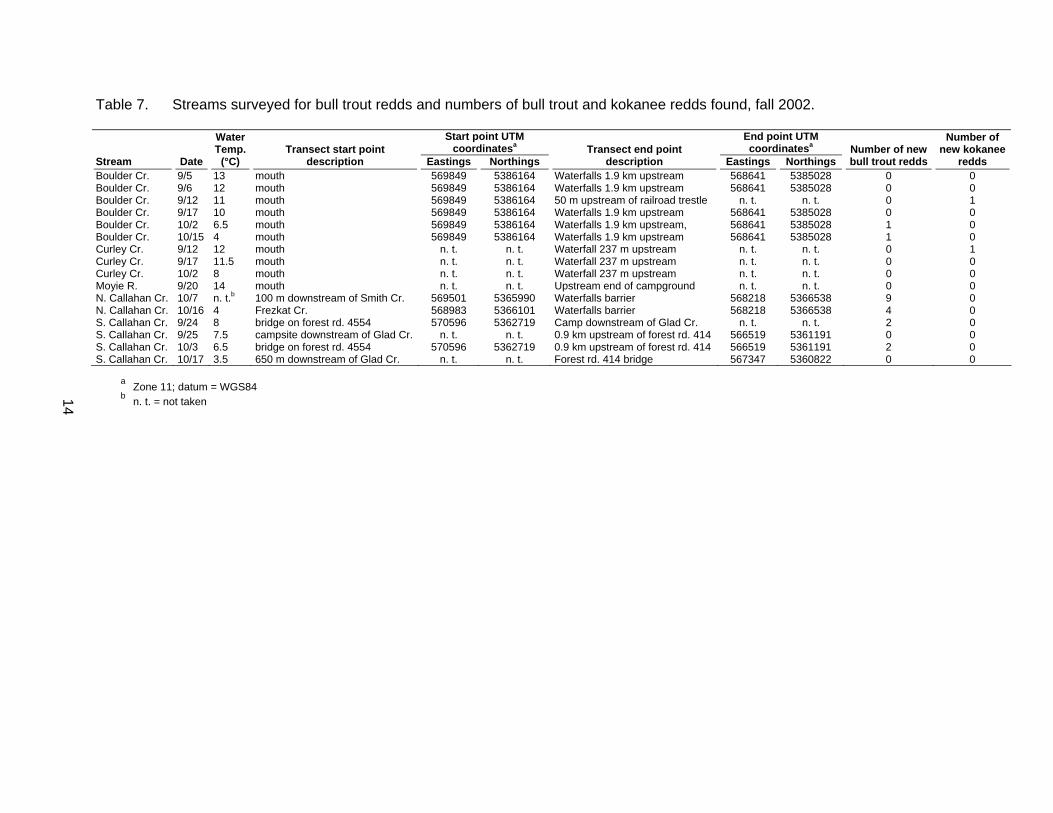
Table 7. Streams surveyed for bull trout redds and numbers of bull trout and kokanee redds found, fall 2002.
Water Temp. Transect start point
Start point UTM coordinatesa Transect end point
End point UTM coordinatesa Number of new
Number of new kokanee
Stream Date (°C) description Eastings Northings description Eastings Northings bull trout redds redds Boulder Cr. 9/5 13 mouth 569849 5386164 Waterfalls 1.9 km upstream 568641 5385028 0 0 Boulder Cr. 9/6 12 mouth 569849 5386164 Waterfalls 1.9 km upstream 568641 5385028 0 0 Boulder Cr. 9/12 11 mouth 569849 5386164 50 m upstream of railroad trestle n. t. n. t. 0 1 Boulder Cr. 9/17 10 mouth 569849 5386164 Waterfalls 1.9 km upstream 568641 5385028 0 0 Boulder Cr. 10/2 6.5 mouth 569849 5386164 Waterfalls 1.9 km upstream, 568641 5385028 1 0 Boulder Cr. 10/15 4 mouth 569849 5386164 Waterfalls 1.9 km upstream 568641 5385028 1 0 Curley Cr. 9/12 12 mouth n. t. n. t. Waterfall 237 m upstream n. t. n. t. 0 1 Curley Cr. 9/17 11.5 mouth n. t. n. t. Waterfall 237 m upstream n. t. n. t. 0 0 Curley Cr. 10/2 8 mouth n. t. n. t. Waterfall 237 m upstream n. t. n. t. 0 0 Moyie R. 9/20 14 mouth n. t. n. t. Upstream end of campground n. t. n. t. 0 0 N. Callahan Cr. 10/7 n. t.b 100 m downstream of Smith Cr. 569501 5365990 Waterfalls barrier 568218 5366538 9 0 N. Callahan Cr. 10/16 4 Frezkat Cr. 568983 5366101 Waterfalls barrier 568218 5366538 4 0 S. Callahan Cr. 9/24 8 bridge on forest rd. 4554 570596 5362719 Camp downstream of Glad Cr. n. t. n. t. 2 0 S. Callahan Cr. 9/25 7.5 campsite downstream of Glad Cr. n. t. n. t. 0.9 km upstream of forest rd. 414 566519 5361191 0 0 S. Callahan Cr. 10/3 6.5 bridge on forest rd. 4554 570596 5362719 0.9 km upstream of forest rd. 414 566519 5361191 2 0 S. Callahan Cr. 10/17 3.5 650 m downstream of Glad Cr. n. t. n. t. Forest rd. 414 bridge 567347 5360822 0 0
a Zone 11; datum = WGS84 b n. t. = not taken
14
15
Rainbow Trout Population Size Structure
Eighty-three rainbow trout were collected during 3.87 h of fall electrofishing effort. Total catch-per-unit-effort for rainbow trout was 7.0/h for fish ≤200 mm TL, 6.5/h for the 200-305 mm TL group, 7.8/h for the 306-406 mm TL group, and 0.3/h for fish >406 mm TL. The relative weights for the 201-305 mm TL and 306-406 mm TL size groups were 83 (SE = 1; n = 25) and 80 (SE = 1; n = 30), respectively. One rainbow trout >406 mm was sampled during fall electrofishing. This fish was 468 mm with a relative weight of 96. The rainbow trout PSD was 55 ± 15, while the QSD was 2.
DISCUSSION
Rainbow trout adults were successfully trapped at the weir and by electrofishing in Caboose Creek and transported upstream of the railroad culverts. I could not determine if this effort helped increase spawning activity as no redds were observed during spring surveys of Caboose Creek. However, drift net sampling showed that successful spawning did occur in Caboose Creek. Limited visibility due to the dense canopy shading Caboose Creek may have hindered identification of redds.
Transporting rainbow trout adults upstream of the Caboose Creek culverts did not
appear to increase age-0 production relative to the reference stream. Age-0 rainbow trout production in Caboose Creek (1,215 summer out-migrants) was similar to that in Debt Creek (1,111 summer out-migrants). The number of out-migrants from both creeks in 2002 was higher than in 2000 when an estimated 868 and 383 age-0 rainbow trout out-migrated from Caboose and Debt creeks, respectively (Walters 2002).
High spring flows in the Moyie River in 2002 caused an apparent change to the river
channel, decreasing the elevation difference between the proposed spawning channel inlet and outlet. An evaluation of the spawning channel site prior to the spring 2002 flows determined that the channel would have to be excavated approximately 1 m deep in order to deliver enough water for suitable spawning conditions (M. Maffey, IDFG engineer, personal communication). Suitable spawning conditions would include a minimum depth of 0.18 m and velocity of 0.19 to 0.48 m/s (IDFG unpublished data; H. Manson, B. C. Hydro, personal communication). Because the elevation difference between the inlet and outlet is now <1 m, the spawning channel could not be excavated and still provide suitable spawning flows. The possibility of placing a rock weir at the channel inlet to increase the head was also considered. This manipulation to the main river channel would likely divert some of the river’s energy to the shore opposite the spawning channel, causing the river to further degrade there and resulting in even less water available to the spawning channel site (M. Maffey, IDFG engineer, personal communication).
Water temperatures in most reaches of Deep Creek exceeded optimal levels for rainbow
trout and may be a limiting factor to the population downstream of McArthur Lake. These high temperatures (≥22°C) may explain why juvenile densities are low in Deep Creek relative to several Deep Creek tributaries (Paragamian 1995a; Fredericks and Hendricks 1997; Downs 1999). Carlander (1969) reported an optimum temperature for rainbow trout as below 21°C, while Becker (1983) reported that rainbow trout tended to concentrate where temperatures were between 15.6 and 21.1°C. Laboratory experiments indicate that trout reduce and finally cease

16
feeding as water temperatures rise to between 22 and 25°C (Dickson and Kramer 1971), while young Kamloops rainbow trout acclimated at 11°C died at 24°C (Black 1953).
Both tributaries that flow into McArthur Lake, Deep Creek and Dodge Creek, remained
below 20°C throughout the summer. However, base flows in Deep Creek upstream of McArthur Lake were minimal (estimated <0.01 m3/s), so this section probably provides little rainbow trout rearing habitat. Planned sampling of temperature and dissolved oxygen profiles in McArthur Lake had to be cancelled because the lake was drained in 2002.
A total of seven radio-tagged rainbow trout have been located in Boulder Creek during
the spring spawning season from 1999-2002, while a maximum of two radio-tagged rainbow trout were located in other Kootenai River tributaries during the same period (Walters and Downs 2001, Walters 2002, 2003). This suggests that Boulder Creek supports the highest number of rainbow trout spawners in the Kootenai River, Idaho upstream of Bonners Ferry.
Boulder Creek also produced the highest number of age-0 rainbow trout out-migrants of
the streams sampled with drift nets in 2002, supporting previous findings that this stream is the largest source of rainbow trout recruits to the Kootenai River, Idaho upstream of Bonners Ferry (Downs 2000; Walters 2002, 2003). The survival rate of the age-0 out-migrants upon reaching the Kootenai River is unknown. August snorkel surveys show at least three age-classes of rainbow trout rearing in Boulder Creek, suggesting that some juveniles could out-migrate at age-1 or older (Fredericks and Hendricks 1997; Downs 1999; Walters 2002, 2003). Determining out-migrant survival rates and sources of juvenile mortality could aid management efforts to increase rainbow trout recruitment. Determining which age-class of out-migrants ultimately contributes the most recruits to the adult population could also aid management efforts to increase adult densities.
Tributary stream water temperature seemed to be an important factor guiding when
rainbow trout entered tributaries to spawn. Four of five rainbow and westslope cutthroat trout documented in tributaries during this study were first located when the water temperature was 6°C. Hartman (1969) reported that Gerrard stock rainbow trout from Kootenay Lake move onto spawning areas in the Lardeau River when temperatures reach about 5°C. He reported these conditions might not be causal but merely associated with other environmental conditions that affect the fish. In Ontario, rainbow trout movement into a spawning tributary of Lake Huron was triggered by winter freshets and rises in water temperature in the tributary (Dodge and MacCrimmon 1971).
The rainbow trout that was radio-tagged in the Kootenai River and eventually located in
Kootenay Lake, British Columbia supports anecdotal evidence of adfluvial fish from Kootenay Lake spawning in tributaries upstream of Bonners Ferry. In addition, 15 rainbow trout >406 mm TL were sampled during spring electrofishing for 2000, 2001, and 2002 combined, but only three fish this size were sampled during fall 1999, 2000, and 2001 combined (IDFG, unpublished data). These data also suggest that larger fish are migrating upstream from Kootenay Lake in the spring to spawn in the Kootenai River watershed in Idaho and Montana. Therefore, an unknown proportion of juvenile rainbow trout out-migrants from tributary streams likely rear in Kootenay Lake and not in the Kootenai River.
This study is the first to document bull trout redds in the Callahan Creek drainage in
Idaho. The size of many of the bull trout seen during redd surveys suggests they are likely fluvial fish from the Kootenai River or adfluvial fish from Kootenay Lake. Regardless, North and South Callahan creeks are the only streams with significant bull trout reproduction in the

17
Kootenai River drainage in Idaho (Walters and Downs 2001; Walters 2002, 2003). Therefore, bull trout redd count index reaches should be established on North and South Callahan creeks for annual monitoring of the spawning population. This should include more extensive bull trout redd surveys of North Callahan Creek to determine if spawning occurs outside of the reach surveyed in 2002. Little else is known about the bull trout population in the Callahan drainage. Additional research on this population such as out-migration rates and rearing densities could help with conservation management and help determine if this population meets draft bull trout recovery plan criteria.
I documented an increase in rainbow trout PSD since implementation of more restrictive
trout regulations on the Kootenai River. The 2002 rainbow trout PSD (54) was higher than in 2001 and 2000 when the PSD’s were 24 and 39, respectively (Walters 2002; Walters 2003). The 2002 QSD (2) was slightly higher than in 2001 when the QSD was zero but the same as in 2000 (Walters 2002; Walters 2003). The 2002 PSD was near the upper end of the 1-63 PSD range, while the 2002 QSD was near the lower end of the 0-42 QSD range reported for wild trout fisheries in Idaho (Schill 1991). Rainbow trout PSD estimates for the Kootenai River should be considered in the context of the low-density population. For example, PSD estimates are lower for the rainbow trout population in the Flower-Pipe section of the Kootenai River, Montana (Montana Department of Fish, Wildlife and Parks, unpublished data). This appears to be a result of a higher proportion of juveniles (≤200 mm) in Montana, suggesting better recruitment, while densities of fish >200 mm are up to an order of magnitude higher than in Idaho.
RECOMMENDATIONS
1. Due to the problems identified with the proposed Moyie River spawning channel site, I recommend abandoning this project and looking at alternate options of increasing rainbow trout recruitment.
2. Determine if there are options to decrease summer water temperatures in Deep Creek. 3. Management of the Callahan Creek watershed should give bull trout a high priority along
with the native redband rainbow trout population (Allendorf et al. 1980; Knudsen et al. 2002).
4. Repeat bull trout redd surveys in the Callahan drainage and establish index transects
that could be completed annually. 5. Continue monitoring the Kootenai River rainbow trout population annually to measure
the effects of the new bag and size limits.

18
ACKNOWLEDGEMENTS
Bobby Duncan, Jeremy Duehr, Jessica Erickson, Brian Gunderman, Ryan Hardy, Cory Keddish, Vaughn Paragamian, Shane Rewaldt, Pete Rust, and Zeke Steele assisted with field, lab, and data entry work. Diane Wakkinen completed telemetry flights. Don Vickaryous allowed the use of his boat launch on the Kootenai River. Steve Elle, Greg Hoffman, and Vaughn Paragamian and Dan Schill reviewed and commented on drafts of the report. Cheryl Leben prepared the report for printing.

19
LITERATURE CITED
Allendorf, F. W., D. M. Espeland, D. T. Scow, and S. Phelps. 1980. Coexistence of native and introduced rainbow trout in the Kootenai River drainage. Proceedings of the Montana Academy of Sciences 39:28-36.
Anderson, R. O. 1976. Management of small warm water impoundments. Fisheries 1(6):5-7,
26-28. Anderson, R. O., and R. M. Neuman. 1996. Length, weight, and associated structural indices.
Pages 447-482 in B. R. Murphy and D. W. Willis, editors. Fisheries Techniques, 2nd edition. American Fisheries Society, Bethesda, Maryland.
Becker, G. C. 1983. Fishes of Wisconsin. The University of Wisconsin Press, Madison,
Wisconsin. 1,052 pp. Black, E. C. 1953. Upper lethal temperatures of some British Columbia freshwater fishes.
Journal of the Fisheries Research Board of Canada 10(4):196-210. Carlander, K. D. 1969. Handbook of freshwater fishery biology. Volume 1. Iowa State University
Press, Ames, Iowa. 752 pp. Chapman, D. W., and B. May. 1986. Downstream movement of rainbow trout past Kootenai
Falls, Montana. North American Journal of Fisheries Management 6:47-51. Dickson, I. W., and R. H. Kramer. 1971. Factors influencing scope for activity and active and
standard metabolism of rainbow trout Salmo gairdneri. Journal of the Fisheries Research Board of Canada 28:587-596.
Dodge, D. P., and H. R. MacCrimmon. 1971. Environmental influences on extended spawning
of rainbow trout Salmo gairdneri. Transactions of the American Fisheries Society 100:312-318.
Downs, C. C. 1999. Kootenai River fisheries investigations: Rainbow trout recruitment. 1997
Annual report to Bonneville Power Administration. Project 88-65. Idaho Department of Fish and Game, Boise, Idaho.
Downs, C. C. 2000. Kootenai River fisheries investigations: Rainbow trout recruitment. 1998
Annual report to Bonneville Power Administration. Project 88-65. Idaho Department of Fish and Game, Boise, Idaho.
Dunham, J., B. Rieman, and K. Davis. 2001. Sources and magnitude of sampling error in redd
counts for bull trout. North American Journal of Fisheries Management 21:343-352. Fredericks, J., and S. Hendricks. 1997. Kootenai River fisheries investigations: Rainbow trout
recruitment investigations. 1996 Annual report to Bonneville Power Administration, Project 88-65. Idaho Department of Fish and Game. Boise, Idaho.
Grost, R. T., W. A. Hubert, and T. A. Wesche. 1991. Description of brown trout redds in a
mountain stream. Transactions of the American Fisheries Society 120:582-588.

20
Gustafson, K. A. 1988. Approximating confidence intervals for indices of fish population size
structure. North American Journal of Fisheries Management 8:139-141. Hartman, G. F. 1969. Reproductive biology of the Gerrard stock rainbow trout. Pages 53-67 in
T. G. Northcote, ed., Symposium on Trout and Salmon in Streams. Institute of Fisheries, the University of British Columbia, Vancouver, British Columbia.
Knudsen, K. L., C. C. Muhlfeld, G. K. Sage, and R. F. Leary. 2002. Genetic structure of
Columbia River redband trout populations in the Kootenai River drainage, Montana, revealed by microsatellite and allozyme loci. Transactions of the American Fisheries Society 131:1093-1105.
May, B., and J. Huston. 1979. Kootenai River fisheries investigations, final job report, contract
no. DACW 67-76-C-0055. Montana Department of Fish and Game. 57 pp. Muth, R. T., and J. C. Schmulbach. 1984. Downstream transport of fish larvae in a shallow
prairie river. Transactions of the American Fisheries Society 113:224-230. Paragamian, V. L. 1995a. Kootenai River fisheries investigation: Stock status of burbot and
rainbow trout and fisheries inventory. Idaho Department of Fish and Game, 1994 Annual Report to Bonneville Power Administration, Project 88-65. Boise, Idaho.
Paragamian, V. L. 1995b. Kootenai River fisheries investigations: Stock status of burbot and
rainbow trout and fisheries inventory. Idaho Department of Fish and Game, 1995 Annual Report to Bonneville Power Administration, Project 88-65. Boise, Idaho.
Paragamian, V. L. 2000. The effects of variable flows on burbot spawning migrations in the
Kootenai River, Idaho, USA, and Kootenay Lake, British Columbia, Canada, after construction of the Libby Dam. Pages 111-123 in V. L. Paragamian and D. W. Willis, editors, Burbot biology, ecology, and management. American Fisheries Society, Fisheries Management Section, Publication Number 1, Bethesda, Maryland.
Paragamian, V. L., and G. Kruse. 2001. Kootenai River white sturgeon spawning migration
behavior and a predictive model. North American Journal of Fisheries Management 21:10-21.
Partridge, F. 1983. Kootenai River fisheries investigations. Idaho Department of Fish and Game.
Job Completion Report, Project F-73-R-5. Boise, Idaho. Richards, D. 1997. Kootenai River biological baseline status report. Kootenai Tribe of Idaho
report to Bonneville Power Administration, Project 94-49. Bonners Ferry, Idaho. Schill, D. J. 1991. Wild trout investigations. Idaho Department of Fish and Game. Job
Performance Report. Project F-73-R-13, Job 1. Boise, Idaho. Shepard, B. B., and P. J. Graham. 1983. Fish resource monitoring program for the upper
flathead basin. Flathead River Basin Environmental Study, EPA Contract No. R008224-01-4.
21
Simpkins, D. G., and W. A. Hubert. 1996. Proposed revision of the standard-weight equation for rainbow trout. Journal of Freshwater Ecology 11:319-325.
U.S. Fish and Wildlife Service. 2002. Chapter 4, Kootenai River Recovery Unit. 89 p. In: U.S.
Fish and Wildlife Service. Bull trout Salvelinus confluentus draft recovery plan. Portland, Oregon.
Walters, J. P. 2002. Kootenai River fisheries investigations: rainbow and bull trout recruitment.
Annual progress report to Bonneville Power Administration, April 1, 2000-March 31, 2001. Project 1988-06500. Idaho Department of Fish and Game. Boise, Idaho.
Walters, J. P. 2003. Kootenai River fisheries investigations: rainbow and bull trout recruitment.
Annual progress report to Bonneville Power Administration, April 1, 2001-March 31, 2002. Project 1988-06500. Idaho Department of Fish and Game. Boise, Idaho.
Walters, J. P., and C. C. Downs. 2001. Kootenai River fisheries investigations: rainbow and bull
trout recruitment. 1999 Annual report to Bonneville Power Administration. Project 1988-06500. Idaho Department of Fish and Game. Boise, Idaho.
Wege, G. J., and R. O. Anderson. 1978. Relative weight (Wr): a new index of condition for
largemouth bass. Pages 79-91 in G. D. Novinger and J. G. Dillard, editors. New approaches to the management of small impoundments. American Fisheries Society, North Central Division, Special Publication 5. Bethesda, Maryland.

22
APPENDICES
23
Appendix A. Daily water temperatures at six sites in the Deep Creek drainage, Idaho, summer and fall 2002.
Dodge Creek at Road Crossing 0.5 km Upstream of McArthur Reservoir
0.002.004.006.008.00
10.0012.0014.0016.0018.0020.0022.0024.00
7/3/20
02
7/10/2
002
7/17/2
002
7/24/2
002
7/31/2
002
8/7/20
02
8/14/2
002
8/21/2
002
8/28/2
002
9/4/20
02
9/11/2
002
9/18/2
002
9/25/2
002
10/2/
2002
10/9/
2002
10/16
/2002
10/23
/2002
10/30
/2002
Date
Wat
er T
empe
ratu
re (C
)
daily avg. daily min. daily max.
Deep Creek at Road Crossing 1.4 km Upstream of McArthur Reservoir
0.00
2.00
4.00
6.00
8.00
10.00
12.00
14.00
16.00
18.00
7/3/20
02
7/10/2
002
7/17/2
002
7/24/2
002
7/31/2
002
8/7/20
02
8/14/2
002
8/21/2
002
8/28/2
002
9/4/20
02
9/11/2
002
9/18/2
002
9/25/2
002
10/2/
2002
10/9/
2002
10/16
/2002
10/23
/2002
10/30
/2002
Date
Wat
er T
empe
ratu
re (C
)
daily avg. daily min. daily max.

24
Appendix A. Continued.
Deep Creek 0.5 km Downstream of McArthur Reservoir
0.002.004.006.008.00
10.0012.0014.0016.0018.0020.0022.0024.0026.00
6/17/2
002
6/24/2
002
7/1/20
02
7/8/20
02
7/15/2
002
7/22/2
002
7/29/2
002
8/5/20
02
8/12/2
002
8/19/2
002
8/26/2
002
9/2/20
02
9/9/20
02
9/16/2
002
9/23/2
002
9/30/2
002
10/7/
2002
10/14
/2002
10/21
/2002
10/28
/2002
11/4/
2002
Date
Wat
er T
empe
ratu
re (C
)
daily avg. daily min. daily max.
Deep Creek at Highway 95 Bridge at Naples
0.002.004.006.008.00
10.0012.0014.0016.0018.0020.0022.0024.0026.00
7/3/20
02
7/10/2
002
7/17/2
002
7/24/2
002
7/31/2
002
8/7/20
02
8/14/2
002
8/21/2
002
8/28/2
002
9/4/20
02
9/11/2
002
9/18/2
002
9/25/2
002
10/2/
2002
10/9/
2002
10/16
/2002
10/23
/2002
10/30
/2002
Date
Wat
er T
empe
ratu
re (C
)
daily ave. daily min. daily max.

25
Appendix A. Continued.
Deep Creek at 2nd Bridge Crossing on Old Highway 95 North of Naples
-202468
101214161820222426
7/3/20
02
7/10/2
002
7/17/2
002
7/24/2
002
7/31/2
002
8/7/20
02
8/14/2
002
8/21/2
002
8/28/2
002
9/4/20
02
9/11/2
002
9/18/2
002
9/25/2
002
10/2/
2002
10/9/
2002
10/16
/2002
10/23
/2002
10/30
/2002
Date
Wat
er T
empe
ratu
re (C
)
daily avg. daily min. daily max.
Deep Creek at 1st Bridge North of the Deep Creek Inn
0.002.004.006.008.00
10.0012.0014.0016.0018.0020.0022.0024.0026.00
7/3/20
02
7/10/2
002
7/17/2
002
7/24/2
002
7/31/2
002
8/7/20
02
8/14/2
002
8/21/2
002
8/28/2
002
9/4/20
02
9/11/2
002
9/18/2
002
9/25/2
002
10/2/
2002
10/9/
2002
10/16
/2002
10/23
/2002
10/30
/2002
Date
Wat
er T
empe
ratu
re (C
)
daily avg. daily min. daily max.
26
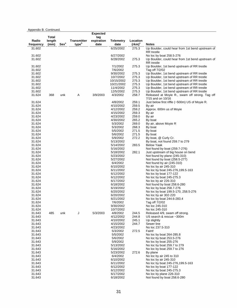
Appendix B. Telemetry locations for radio-tagged rainbow trout with active transmitters in 2002.
Radio frequency
Total length (mm) Sexa
Transmitter typeb
Expected tag
expiration date
Telemetry date
Location (rkm)c Notes
30.120 560 m F 3/2/2003 4/12/2001 268.5 Caught between Caboose and Debt Creek-released at Debt Cr; got water in incision during surgery; dissolvable sutures used; hooked jaw, looked like testes seen through incision
30.120 4/13/2001 267.1 Boat 30.120 4/16/2001 268.2 Boat 30.120 4/23/2001 269.6 Boat 30.120 5/2/2001 Not located 150-285 or Deep Cr. 30.120 5/9/2001 Aerial-not downriver 285-113 30.120 5/18/2001 299.5 Aerial-@Callahan Cr. 30.120 5/23/2001 299.5 Aerial-up Callahan 30.120 5/30/2001 299.5 Aerial-up Callahan @ Hwy 30.120 6/11/2001 No loc from 214-305 30.120 7/11/2001 No loc from 245-310 30.120 7/25/2001 No loc from 245-310 30.120 8/1/2001 No loc from 245-315 30.120 8/8/2001 No loc from 245-310 30.120 8/16/2001 No loc from 245-310 30.120 8/22/2001 No loc 207-310 30.120 8/29/2001 No loc 245-310 30.120 9/7/2001 No loc 245-310 30.120 9/24/2001 No loc 245-310 30.120 10/3/2001 No loc 245-305 30.120 10/10/2001 No loc 245-305 30.120 10/17/2001 No loc 245-310 30.120 10/24/2001 No loc 245-305 30.120 11/5/2001 No loc 245-305 30.120 12/27/2001 No loc 121-303.5 30.120 4/10/2002 No loc 200 to 304 30.120 4/15/2002 No loc 113-304 30.120 5/7/2002 No loc 245-305 30.120 6/4/2002 No loc 245-310 30.120 6/24/2002 No loc by air 271-310 30.120 7/11/2002 192.0 At Jerome slough 30.120 7/15/2002 192.0 At Jerome slough 30.120 8/5/2002 193.5 Moved upstream 30.120 8/16/2002 193.5 Same 30.120 10/2/2002 192.2 Bend above Jerome slough 30.120 10/15/2002 192.2 Bend above Jerome slough 30.120 12/3/2002 192.2 Bend above Jerome slough 30.120 12/14/2002 192.2 Bend above Jerome slough 31.253 421 f H 3/1/2002 3/21/2001 265.0 Capt/rel @ Hemlock 31.253 3/23/2001 260.4 Boat 31.253 3/27/2001 260.0 Boat 31.253 4/2/2001 259.5 Boat 31.253 4/9/2001 258.6 Boat 31.253 4/16/2001 Boat-not located from Crossport to Boulder Creek 31.253 4/22/2001 258.6 Up Moyie River beneath highway bridge 31.253 5/2/2001 257.3 31.253 5/6/2001 256.3 Boat 31.253 5/18/2001 256.3 Aerial-above bend 31.253 5/21/2001 256.3 Boat 31.253 5/23/2001 256.3 31.253 5/26/2001 256.3 Boat 31.253 5/30/2001 256.3 Above bend upstream Crossport 31.253 6/11/2001 256.0 Down 0.3 rkm 31.253 6/21/2001 OFF until 9/21/01 31.253 7/5/2001 No loc 31.253 9/24/2001 257.5 Bend above Crossport 31.253 10/3/2001 256.0 @ Bend, down a bit 31.253 10/10/2001 256.0 Bend above Crossport 31.253 10/17/2001 257.5 Upstream

27
Appendix B. Continued.
Radio frequency
Total length (mm) Sexa
Transmitter typeb
Expected tag
expiration date
Telemetry date
Location (rkm)c Notes
31.253 10/24/2001 257.3 Upstream 31.253 11/5/2001 257.3 Same 31.253 12/12/2001 257.3 Bend above Crossport 31.253 12/27/2001 256.3 31.253 2/13/2002 256.3 31.272 366 U H 3/1/2002 3/21/2001 265.0 Capt/rel @ Hemlock; used staples to close
incision 31.272 3/23/2001 265.4 Boat loc 31.272 3/27/2001 264.9 Boat loc 31.272 4/2/2001 31.272 4/9/2001 264.8 Boat loc 31.272 4/18/2001 264.8 31.272 4/23/2001 274.2 Boat loc 31.272 5/2/2001 Not located 31.272 5/9/2001 Aerial-not downriver 245-113 31.272 5/18/2001 285.5 31.272 5/23/2001 285.2 Aerial 31.272 5/30/2001 285.6 Star Cr. Confluence in KR 31.272 6/11/2001 265.0 Hemlock reach 31.272 6/21/2001 OFF until 9/21/01 31.272 9/24/2001 264.1 Hemlock reach, quiet 31.272 10/3/2001 263.5 On 9/21/01 31.272 10/10/2001 263.5 Hemlock reach 31.272 10/17/2001 263.5 Hemlock reach 31.272 10/24/2001 264.0 Upstream 31.272 11/5/2001 264.0 Same 31.272 12/12/2001 264.0 Hemlock reach 31.272 12/27/2001 264.1 31.272 2/13/2002 264.1 31.272 3/13/2002 264.1 31.462 471 M A 4/18/2003 5/13/2002 270.7 Caught in weir trap heading upstream in Caboose
Cr., released 50 m above Caboose Cr. culverts 31.462 5/16/2002 270.7 In plunge pool below the culverts in Caboose Cr. 31.462 5/18/2002 270.7 In plunge pool below the culverts in Caboose Cr. 31.462 5/23/2002 270.7 D. W. recorded that the fish was in the Kootenai
R. (located by plane) 31.462 5/27/2002 270.7 Unknown if fish was in Caboose Creek, probably
just picked up the signal from the Kootenai R while going by in boat
31.462 5/29/2002 270.7 D. W. recorded that the fish was at the "confluence" (located by plane), implying the fish was in the river.
31.462 5/30/2002 270.7 Unknown if fish was in Caboose Creek, probably just picked up the signal from the Kootenai R while going by in boat
31.462 5/31/2002 270.7 In plunge pool below the culverts in Caboose Cr. 31.462 6/3/2002 270.7 Up Caboose Cr., below culverts 31.462 6/4/2002 270.7 D. W. just gives the rkm, implying she thought the
fish was in the river (?) 31.462 6/5/2002 270.7 Unknown if fish was in Caboose Creek, probably
just picked up the signal from the Kootenai R while going by in boat
31.462 6/6/2002 270.7 Unknown if fish was in Caboose Creek, probably just picked up the signal from the Kootenai R while going by in boat
31.462 6/10/2002 No loc by air 245-310 31.462 6/11/2002 No loc by boat 245-276, 199.5-163 31.462 6/12/2002 No loc by boat 177-122 31.462 6/12/2002 No loc by boat 245-275.3 31.462 6/15/2002 224.5 Fixed loc at Flemming Cr. 31.462 6/17/2002 No loc by plane 226-310 31.462 6/18/2002 No loc by boat 258.6-280 31.462 6/19/2002 No loc by boat 258.7-276 31.462 6/20/2002 No loc by boat 199.5-170, 258.5-276 31.462 6/20/2002 No loc by air 302-192

28
Appendix B. Continued.
Radio frequency
Total length (mm) Sexa
Transmitter typeb
Expected tag
expiration date
Telemetry date
Location (rkm)c Notes
31.462 6/21/2002 No loc by boat 244.6-283.4 31.462 7/11/2002 No loc by boat 170-245 31.462 7/12/2002 No loc by boat 246-276 31.462 12/3/2002 Dead or gone 31.482 356 unk A 3/29/2003 4/23/2002 262.4 Tagged on night of 4/23, was going to release
next morning but it escaped from holding pen 31.482 4/30/2002 Not found by boat 253-276 31.482 5/3/2002 264.0 Upstream 31.482 5/5/2002 264.0 By boat 31.482 5/6/2002 263.8 By boat 31.482 5/9/2002 264.0 By boat 31.482 5/13/2002 263.0 By boat, moved down 31.482 5/14/2002 263.0 By boat 31.482 5/16/2002 263.0 By boat 31.482 5/18/2002 263.0 By boat 31.482 5/23/2002 263.6 By plane 31.482 5/27/2002 263.6 By boat 31.482 5/29/2002 263.6 By air 31.482 5/30/2002 263.6 By boat 31.482 5/31/2002 263.6 By boat 31.482 6/3/2002 264.0 By boat 31.482 6/4/2002 264.0 By air 31.482 6/5/2002 264.0 By boat 31.482 6/6/2002 264.0 By boat 31.482 6/10/2002 264.0 By air 31.482 6/12/2002 264.0 50 m US powerline 31.482 6/17/2002 264.0 50 m US powerline 31.482 6/18/2002 264.0 50 m US powerline 31.482 6/19/2002 264.0 50 m US powerline 31.482 6/20/2002 264.0 50 m US powerline 31.482 6/24/2002 264.0 50 m US powerline 31.482 6/27/2002 264.0 50 m US powerline 31.482 7/1/2002 263.9 Near powerline 31.482 7/6/2002 264.2 By boat 31.482 7/10/2002 263.9 By boat 31.482 7/15/2002 264.1 Below Katka 31.482 7/22/2002 No loc 199-310, tag off 7/22/02 31.482 10/21/2002 264.1 Below Katka 31.482 11/4/2002 264.1 Below Katka 31.482 12/3/2002 264.1 Below Katka 31.502 349 u A 4/11/2002 5/1/2001 272.2 Tagged and released at Curley Cr.; took 45 min to
recover from surgery. 31.502 5/2/2001 272.1 Boat loc 31.502 5/18/2001 271.5 Aerial-below Curley 31.502 5/21/2001 271.5 Boat loc 31.502 5/23/2001 272.0 Aerial 31.502 5/26/2001 271.6 Boat loc 31.502 5/30/2001 271.6 Below Curley 31.502 6/11/2001 271.6 Below Curley 31.502 6/20/2001 271.6 Below Curley 31.502 6/26/2001 271.5 Boat loc 31.502 7/5/2001 271.6 Below Curley 31.502 7/11/2001 270.7 Below Curley 31.502 7/25/2001 271.0 Below Curley 31.502 8/1/2001 OFF until 11/01/01 31.502 10/3/2001 OFF until 11/01/01 31.502 11/5/2001 271.5 On 31.502 12/12/2001 271.5 31.502 12/27/2001 271.5 31.502 2/14/2002 271.5 31.502 3/13/2002 271.5 31.502 4/10/2002 271.6 Air loc 31.502 4/15/2002 271.6 Below Curley Cr. 31.502 4/23/2002 271.5 Below Curley Cr. 31.502 4/30/2002 271.6 By boat
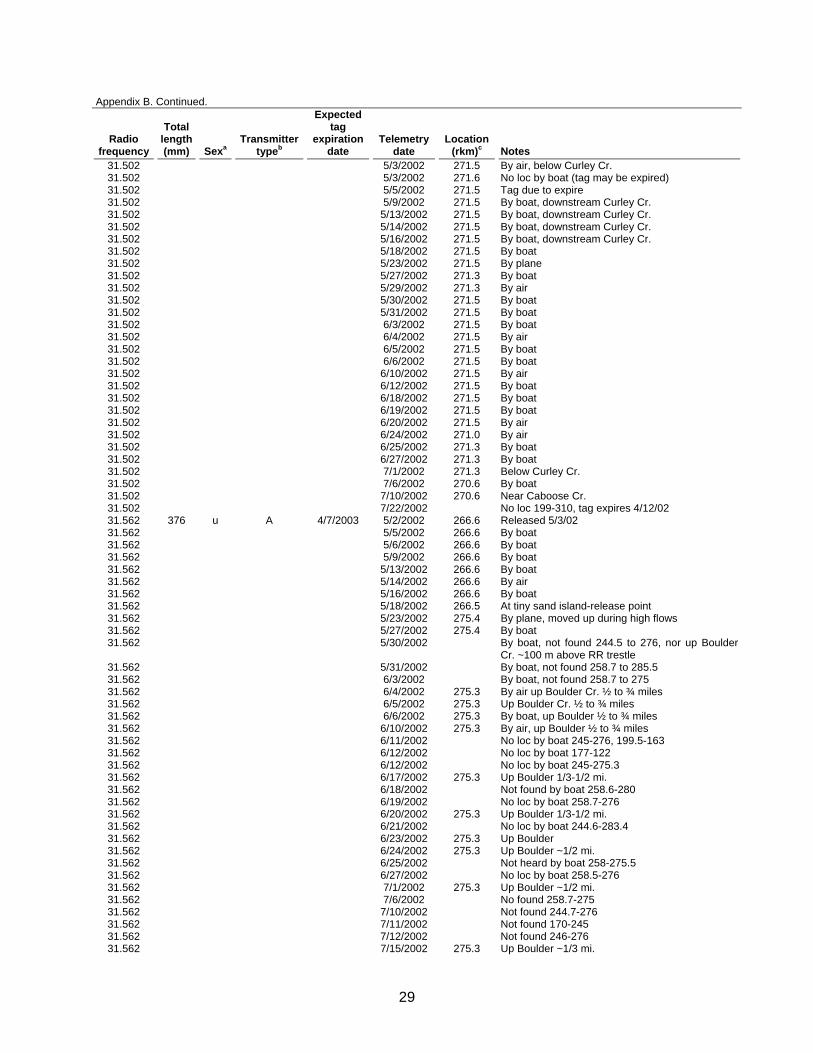
29
Appendix B. Continued.
Radio frequency
Total length (mm) Sexa
Transmitter typeb
Expected tag
expiration date
Telemetry date
Location (rkm)c Notes
31.502 5/3/2002 271.5 By air, below Curley Cr. 31.502 5/3/2002 271.6 No loc by boat (tag may be expired) 31.502 5/5/2002 271.5 Tag due to expire 31.502 5/9/2002 271.5 By boat, downstream Curley Cr. 31.502 5/13/2002 271.5 By boat, downstream Curley Cr. 31.502 5/14/2002 271.5 By boat, downstream Curley Cr. 31.502 5/16/2002 271.5 By boat, downstream Curley Cr. 31.502 5/18/2002 271.5 By boat 31.502 5/23/2002 271.5 By plane 31.502 5/27/2002 271.3 By boat 31.502 5/29/2002 271.3 By air 31.502 5/30/2002 271.5 By boat 31.502 5/31/2002 271.5 By boat 31.502 6/3/2002 271.5 By boat 31.502 6/4/2002 271.5 By air 31.502 6/5/2002 271.5 By boat 31.502 6/6/2002 271.5 By boat 31.502 6/10/2002 271.5 By air 31.502 6/12/2002 271.5 By boat 31.502 6/18/2002 271.5 By boat 31.502 6/19/2002 271.5 By boat 31.502 6/20/2002 271.5 By air 31.502 6/24/2002 271.0 By air 31.502 6/25/2002 271.3 By boat 31.502 6/27/2002 271.3 By boat 31.502 7/1/2002 271.3 Below Curley Cr. 31.502 7/6/2002 270.6 By boat 31.502 7/10/2002 270.6 Near Caboose Cr. 31.502 7/22/2002 No loc 199-310, tag expires 4/12/02 31.562 376 u A 4/7/2003 5/2/2002 266.6 Released 5/3/02 31.562 5/5/2002 266.6 By boat 31.562 5/6/2002 266.6 By boat 31.562 5/9/2002 266.6 By boat 31.562 5/13/2002 266.6 By boat 31.562 5/14/2002 266.6 By air 31.562 5/16/2002 266.6 By boat 31.562 5/18/2002 266.5 At tiny sand island-release point 31.562 5/23/2002 275.4 By plane, moved up during high flows 31.562 5/27/2002 275.4 By boat 31.562 5/30/2002 By boat, not found 244.5 to 276, nor up Boulder
Cr. ~100 m above RR trestle 31.562 5/31/2002 By boat, not found 258.7 to 285.5 31.562 6/3/2002 By boat, not found 258.7 to 275 31.562 6/4/2002 275.3 By air up Boulder Cr. ½ to ¾ miles 31.562 6/5/2002 275.3 Up Boulder Cr. ½ to ¾ miles 31.562 6/6/2002 275.3 By boat, up Boulder ½ to ¾ miles 31.562 6/10/2002 275.3 By air, up Boulder ½ to ¾ miles 31.562 6/11/2002 No loc by boat 245-276, 199.5-163 31.562 6/12/2002 No loc by boat 177-122 31.562 6/12/2002 No loc by boat 245-275.3 31.562 6/17/2002 275.3 Up Boulder 1/3-1/2 mi. 31.562 6/18/2002 Not found by boat 258.6-280 31.562 6/19/2002 No loc by boat 258.7-276 31.562 6/20/2002 275.3 Up Boulder 1/3-1/2 mi. 31.562 6/21/2002 No loc by boat 244.6-283.4 31.562 6/23/2002 275.3 Up Boulder 31.562 6/24/2002 275.3 Up Boulder ~1/2 mi. 31.562 6/25/2002 Not heard by boat 258-275.5 31.562 6/27/2002 No loc by boat 258.5-276 31.562 7/1/2002 275.3 Up Boulder ~1/2 mi. 31.562 7/6/2002 No found 258.7-275 31.562 7/10/2002 Not found 244.7-276 31.562 7/11/2002 Not found 170-245 31.562 7/12/2002 Not found 246-276 31.562 7/15/2002 275.3 Up Boulder ~1/3 mi.

30
Appendix B. Continued.
Radio frequency
Total length (mm) Sexa
Transmitter typeb
Expected tag
expiration date
Telemetry date
Location (rkm)c Notes
31.562 7/22/2002 275.3 Up Boulder ~1/3 mi., tag off 7/31/02 31.562 7/29/2002 275.3 Up Boulder ~1/3 mi., @ bend below the "mine
camps" 31.583 358 unk A 3/17/2003 4/11/2002 268.6 Tagged on 4/11/02. Released at Debt Cr. on
4/12/02 31.583 4/30/2002 270.0 By boat 31.583 5/3/2002 268.2 By boat 31.583 5/5/2002 270.3 By boat, DS of Caboose Cr. ~300 m 31.583 5/6/2002 270.3 By boat, DS of Caboose Cr. ~300 m 31.583 5/9/2002 270.4 By boat, DS of Caboose Cr. ~300 m 31.583 5/13/2002 270.3 By boat, DS of Caboose Cr. ~300 m 31.583 5/14/2002 270.3 By boat, DS of Caboose Cr. ~300 m 31.583 5/16/2002 270.3 By boat 31.583 5/18/2002 270.4 By boat 31.583 5/21/2002 268.4 By boat 31.583 5/23/2002 270.4 By plane, moved up slightly 31.583 5/27/2002 270.4 By boat 31.583 5/29/2002 270.4 By air 31.583 5/30/2002 270.2 By boat 31.583 5/31/2002 270.0 By boat 31.583 6/3/2002 270.0 By boat 31.583 6/4/2002 270.0 By air 31.583 6/5/2002 270.0 By boat 31.583 6/6/2002 270.0 By boat 31.583 6/10/2002 270.0 By air 31.583 6/12/2002 270.3 300 m DS of Caboose 31.583 6/18/2002 270.3 300 m DS of Caboose 31.583 6/19/2002 270.2 By boat 31.583 6/20/2002 269.8 Down slightly 31.583 6/21/2002 269.8 Lost the signal 31.583 6/24/2002 269.8 31.583 6/27/2002 269.8 By boat 31.583 7/1/2002 269.8 By air, dwnstrm of Caboose 31.583 7/6/2002 269.8 DS Caboose 31.583 7/22/2002 No loc 199-310, tag off 7/10/02 31.583 10/7/2002 268.8 DS Caboose 31.583 10/15/2002 269.8 DS Caboose 31.583 10/21/2002 269.8 DS Caboose 31.583 11/4/2002 269.8 DS Caboose 31.583 12/5/2002 269.8 DS Caboose 31.602 331 unk A 3/9/2003 4/3/2002 258.7 Tagged on 4/3/02. Released at Moyie R. on 4/4.
Might have a stronger signal at 31.602. Off 7/15. On 10/16
31.602 4/8/2002 258.5 Approx. 50m DS of Moyie R. 31.602 4/10/2002 258.0 By air 31.602 4/12/2002 258.6 Between mouth of Moyie and boat launch. 31.602 4/15/2002 265.0 Katka 31.602 4/23/2002 283.6 31.602 5/3/2002 295.5 By air, middle of troy air strip 31.602 5/14/2002 299.0 Up 0.9 rkm 31.602 5/23/2002 299.0 By plane 31.602 6/4/2002 275.3 By air up Boulder Cr. ~1/4 mi. (second bend) 31.602 6/5/2002 275.3 Up Boulder Cr. ~1/4 mi. (second bend) 31.602 6/6/2002 275.3 By boat, up Boulder 1/4 mile 31.602 6/10/2002 275.3 By air up Boulder Cr. 1/4 mile 31.602 6/11/2002 No loc by boat 245-276, 199.5-163 31.602 6/12/2002 No loc by boat 177-122 31.602 6/12/2002 No loc by boat 245-275.3 31.602 6/17/2002 275.3 @ Boulder confluence 31.602 6/18/2002 Not found by boat 258.6-280 31.602 6/19/2002 No loc by boat 258.7-276 31.602 6/20/2002 275.3 @ Boulder confluence 31.602 6/21/2002 275.3 Up Boulder, got signal at 1st bend above RR
trestle, weaker than 31.802 31.602 6/23/2002 275.3 Up Boulder
31
Appendix B. Continued.
Radio frequency
Total length (mm) Sexa
Transmitter typeb
Expected tag
expiration date
Telemetry date
Location (rkm)c Notes
31.602 6/25/2002 275.3 Up Boulder, could hear from 1st bend upstream of RR trestle
31.602 6/27/2002 No loc by boat 258.5-276 31.602 6/28/2002 275.3 Up Boulder, could hear from 1st bend upstream of
RR trestle 31.602 7/1/2002 275.3 Up Boulder, 1st bend upstream of RR trestle 31.602 7/6/2002 Tag off 7/2/02 31.602 9/30/2002 275.3 Up Boulder, 1st bend upstream of RR trestle 31.602 10/7/2002 275.3 Up Boulder, 1st bend upstream of RR trestle 31.602 10/15/2002 275.3 Up Boulder, 1st bend upstream of RR trestle 31.602 10/21/2002 275.3 Up Boulder, 1st bend upstream of RR trestle 31.602 11/4/2002 275.3 Up Boulder, 1st bend upstream of RR trestle 31.602 12/5/2002 275.3 Up Boulder, 1st bend upstream of RR trestle 31.624 368 unk A 3/9/2003 4/3/2002 258.7 Released at Moyie R., swam off strong. Tag off
7/15 and on 10/16 31.624 4/8/2002 259.1 Just below first riffle (~500m) US of Moyie R. 31.624 4/10/2002 259.5 By air 31.624 4/12/2002 259.2 Approx. 600m us of Moyie 31.624 4/15/2002 259.3 By air 31.624 4/23/2002 259.0 By air 31.624 4/30/2002 265.2 By boat 31.624 5/3/2002 269.0 By air, above Moyie R 31.624 5/3/2002 268.3 By boat 31.624 5/5/2002 271.5 By boat 31.624 5/6/2002 271.5 By boat 31.624 5/9/2002 272.2 By boat, @ Curly Cr. 31.624 5/13/2002 By boat, not found 259.7 to 279 31.624 5/14/2002 283.5 Below Yaak 31.624 5/16/2002 Not found by boat (259.7-276) 31.624 5/18/2002 282.1 Just upstream of big house on bend 31.624 5/23/2002 Not found by plane (245-310) 31.624 5/27/2002 Not found by boat (258.5-277) 31.624 6/4/2002 Not found by air (245-310) 31.624 6/10/2002 No loc by air 245-310 31.624 6/11/2002 No loc by boat 245-276,199.5-163 31.624 6/12/2002 No loc by boat 177-122 31.624 6/12/2002 No loc by boat 245-275.3 31.624 6/17/2002 No loc by air 226-310 31.624 6/18/2002 Not found by boat 258.6-280 31.624 6/19/2002 No loc by boat 258.7-276 31.624 6/20/2002 No loc by boat 199.5-170, 258.5-276 31.624 6/20/2002 No loc by air 302-220 31.624 6/21/2002 No loc by boat 244.6-283.4 31.624 7/6/2002 Tag off 7/2/02 31.624 9/30/2002 No loc 245-310 31.624 10/7/2002 No loc 245-310 31.643 485 unk J 5/3/2003 4/8/2002 244.5 Released 4/9, swam off strong. 31.643 4/12/2002 244.8 US search & rescue ~300m 31.643 4/10/2002 245.1 Up slightly 31.643 4/15/2002 244.7 Sewer line 31.643 4/23/2002 No loc 237.5-310 31.643 5/3/2002 272.5 Faint! 31.643 5/5/2002 No loc by boat 264-285.8 31.643 5/6/2002 No loc by boat 253.5-276 31.643 5/9/2002 No loc by boat 255-276 31.643 5/13/2002 No loc by boat 259.7 to 279 31.643 5/16/2002 No loc by boat 259.7 to 276 31.643 5/23/2002 272.6 By plane 31.643 6/4/2002 No loc by air 245 to 310 31.643 6/10/2002 No loc by air 245-310 31.643 6/11/2002 No loc by boat 245-276,199.5-163 31.643 6/12/2002 No loc by boat 177-122 31.643 6/12/2002 No loc by boat 245-275.3 31.643 6/17/2002 No loc by plane 226-310 31.643 6/18/2002 Not found by boat 258.6-280
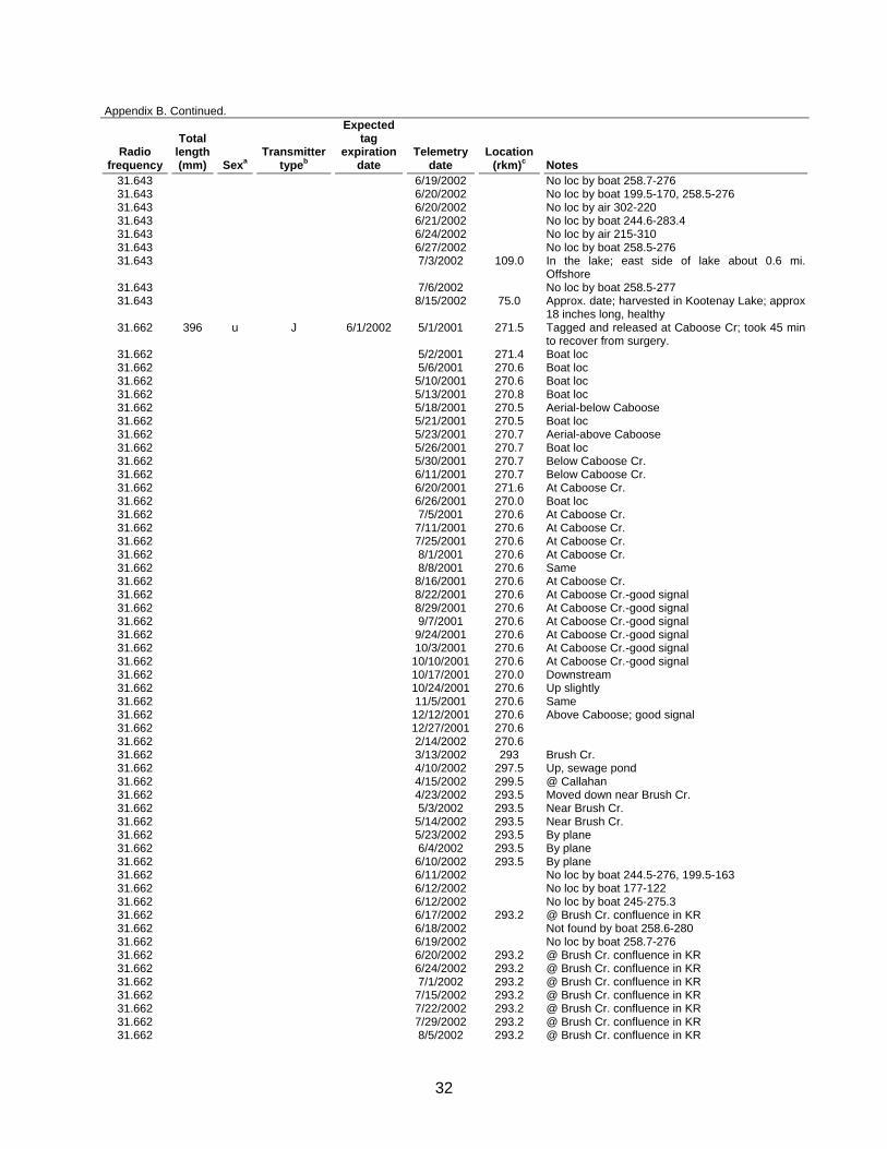
32
Appendix B. Continued.
Radio frequency
Total length (mm) Sexa
Transmitter typeb
Expected tag
expiration date
Telemetry date
Location (rkm)c Notes
31.643 6/19/2002 No loc by boat 258.7-276 31.643 6/20/2002 No loc by boat 199.5-170, 258.5-276 31.643 6/20/2002 No loc by air 302-220 31.643 6/21/2002 No loc by boat 244.6-283.4 31.643 6/24/2002 No loc by air 215-310 31.643 6/27/2002 No loc by boat 258.5-276 31.643 7/3/2002 109.0 In the lake; east side of lake about 0.6 mi.
Offshore 31.643 7/6/2002 No loc by boat 258.5-277 31.643 8/15/2002 75.0 Approx. date; harvested in Kootenay Lake; approx
18 inches long, healthy 31.662 396 u J 6/1/2002 5/1/2001 271.5 Tagged and released at Caboose Cr; took 45 min
to recover from surgery. 31.662 5/2/2001 271.4 Boat loc 31.662 5/6/2001 270.6 Boat loc 31.662 5/10/2001 270.6 Boat loc 31.662 5/13/2001 270.8 Boat loc 31.662 5/18/2001 270.5 Aerial-below Caboose 31.662 5/21/2001 270.5 Boat loc 31.662 5/23/2001 270.7 Aerial-above Caboose 31.662 5/26/2001 270.7 Boat loc 31.662 5/30/2001 270.7 Below Caboose Cr. 31.662 6/11/2001 270.7 Below Caboose Cr. 31.662 6/20/2001 271.6 At Caboose Cr. 31.662 6/26/2001 270.0 Boat loc 31.662 7/5/2001 270.6 At Caboose Cr. 31.662 7/11/2001 270.6 At Caboose Cr. 31.662 7/25/2001 270.6 At Caboose Cr. 31.662 8/1/2001 270.6 At Caboose Cr. 31.662 8/8/2001 270.6 Same 31.662 8/16/2001 270.6 At Caboose Cr. 31.662 8/22/2001 270.6 At Caboose Cr.-good signal 31.662 8/29/2001 270.6 At Caboose Cr.-good signal 31.662 9/7/2001 270.6 At Caboose Cr.-good signal 31.662 9/24/2001 270.6 At Caboose Cr.-good signal 31.662 10/3/2001 270.6 At Caboose Cr.-good signal 31.662 10/10/2001 270.6 At Caboose Cr.-good signal 31.662 10/17/2001 270.0 Downstream 31.662 10/24/2001 270.6 Up slightly 31.662 11/5/2001 270.6 Same 31.662 12/12/2001 270.6 Above Caboose; good signal 31.662 12/27/2001 270.6 31.662 2/14/2002 270.6 31.662 3/13/2002 293 Brush Cr. 31.662 4/10/2002 297.5 Up, sewage pond 31.662 4/15/2002 299.5 @ Callahan 31.662 4/23/2002 293.5 Moved down near Brush Cr. 31.662 5/3/2002 293.5 Near Brush Cr. 31.662 5/14/2002 293.5 Near Brush Cr. 31.662 5/23/2002 293.5 By plane 31.662 6/4/2002 293.5 By plane 31.662 6/10/2002 293.5 By plane 31.662 6/11/2002 No loc by boat 244.5-276, 199.5-163 31.662 6/12/2002 No loc by boat 177-122 31.662 6/12/2002 No loc by boat 245-275.3 31.662 6/17/2002 293.2 @ Brush Cr. confluence in KR 31.662 6/18/2002 Not found by boat 258.6-280 31.662 6/19/2002 No loc by boat 258.7-276 31.662 6/20/2002 293.2 @ Brush Cr. confluence in KR 31.662 6/24/2002 293.2 @ Brush Cr. confluence in KR 31.662 7/1/2002 293.2 @ Brush Cr. confluence in KR 31.662 7/15/2002 293.2 @ Brush Cr. confluence in KR 31.662 7/22/2002 293.2 @ Brush Cr. confluence in KR 31.662 7/29/2002 293.2 @ Brush Cr. confluence in KR 31.662 8/5/2002 293.2 @ Brush Cr. confluence in KR
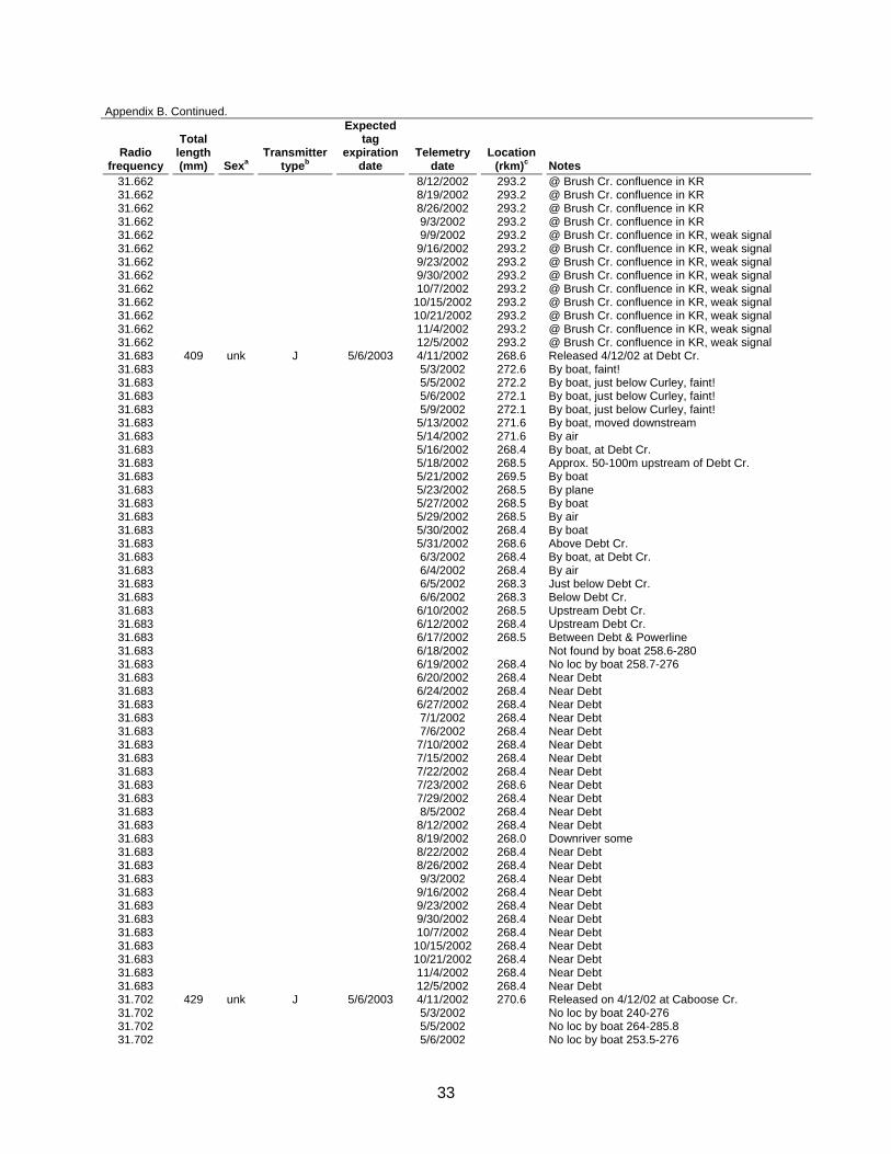
33
Appendix B. Continued.
Radio frequency
Total length (mm) Sexa
Transmitter typeb
Expected tag
expiration date
Telemetry date
Location (rkm)c Notes
31.662 8/12/2002 293.2 @ Brush Cr. confluence in KR 31.662 8/19/2002 293.2 @ Brush Cr. confluence in KR 31.662 8/26/2002 293.2 @ Brush Cr. confluence in KR 31.662 9/3/2002 293.2 @ Brush Cr. confluence in KR 31.662 9/9/2002 293.2 @ Brush Cr. confluence in KR, weak signal 31.662 9/16/2002 293.2 @ Brush Cr. confluence in KR, weak signal 31.662 9/23/2002 293.2 @ Brush Cr. confluence in KR, weak signal 31.662 9/30/2002 293.2 @ Brush Cr. confluence in KR, weak signal 31.662 10/7/2002 293.2 @ Brush Cr. confluence in KR, weak signal 31.662 10/15/2002 293.2 @ Brush Cr. confluence in KR, weak signal 31.662 10/21/2002 293.2 @ Brush Cr. confluence in KR, weak signal 31.662 11/4/2002 293.2 @ Brush Cr. confluence in KR, weak signal 31.662 12/5/2002 293.2 @ Brush Cr. confluence in KR, weak signal 31.683 409 unk J 5/6/2003 4/11/2002 268.6 Released 4/12/02 at Debt Cr. 31.683 5/3/2002 272.6 By boat, faint! 31.683 5/5/2002 272.2 By boat, just below Curley, faint! 31.683 5/6/2002 272.1 By boat, just below Curley, faint! 31.683 5/9/2002 272.1 By boat, just below Curley, faint! 31.683 5/13/2002 271.6 By boat, moved downstream 31.683 5/14/2002 271.6 By air 31.683 5/16/2002 268.4 By boat, at Debt Cr. 31.683 5/18/2002 268.5 Approx. 50-100m upstream of Debt Cr. 31.683 5/21/2002 269.5 By boat 31.683 5/23/2002 268.5 By plane 31.683 5/27/2002 268.5 By boat 31.683 5/29/2002 268.5 By air 31.683 5/30/2002 268.4 By boat 31.683 5/31/2002 268.6 Above Debt Cr. 31.683 6/3/2002 268.4 By boat, at Debt Cr. 31.683 6/4/2002 268.4 By air 31.683 6/5/2002 268.3 Just below Debt Cr. 31.683 6/6/2002 268.3 Below Debt Cr. 31.683 6/10/2002 268.5 Upstream Debt Cr. 31.683 6/12/2002 268.4 Upstream Debt Cr. 31.683 6/17/2002 268.5 Between Debt & Powerline 31.683 6/18/2002 Not found by boat 258.6-280 31.683 6/19/2002 268.4 No loc by boat 258.7-276 31.683 6/20/2002 268.4 Near Debt 31.683 6/24/2002 268.4 Near Debt 31.683 6/27/2002 268.4 Near Debt 31.683 7/1/2002 268.4 Near Debt 31.683 7/6/2002 268.4 Near Debt 31.683 7/10/2002 268.4 Near Debt 31.683 7/15/2002 268.4 Near Debt 31.683 7/22/2002 268.4 Near Debt 31.683 7/23/2002 268.6 Near Debt 31.683 7/29/2002 268.4 Near Debt 31.683 8/5/2002 268.4 Near Debt 31.683 8/12/2002 268.4 Near Debt 31.683 8/19/2002 268.0 Downriver some 31.683 8/22/2002 268.4 Near Debt 31.683 8/26/2002 268.4 Near Debt 31.683 9/3/2002 268.4 Near Debt 31.683 9/16/2002 268.4 Near Debt 31.683 9/23/2002 268.4 Near Debt 31.683 9/30/2002 268.4 Near Debt 31.683 10/7/2002 268.4 Near Debt 31.683 10/15/2002 268.4 Near Debt 31.683 10/21/2002 268.4 Near Debt 31.683 11/4/2002 268.4 Near Debt 31.683 12/5/2002 268.4 Near Debt 31.702 429 unk J 5/6/2003 4/11/2002 270.6 Released on 4/12/02 at Caboose Cr. 31.702 5/3/2002 No loc by boat 240-276 31.702 5/5/2002 No loc by boat 264-285.8 31.702 5/6/2002 No loc by boat 253.5-276
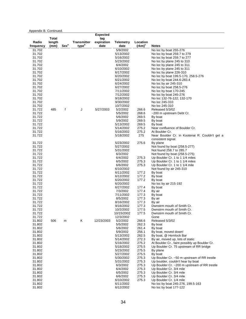
34
Appendix B. Continued.
Radio frequency
Total length (mm) Sexa
Transmitter typeb
Expected tag
expiration date
Telemetry date
Location (rkm)c Notes
31.702 5/9/2002 No loc by boat 255-276 31.702 5/13/2002 No loc by boat 259.7 to 279 31.702 5/16/2002 No loc by boat 259.7 to 277 31.702 5/23/2002 No loc by plane 245 to 310 31.702 6/4/2002 No loc by plane 245 to 311 31.702 6/10/2002 No loc by plane 245 to 311 31.702 6/17/2002 No loc by plane 226-310 31.702 6/20/2002 No loc by boat 199.5-170, 258.5-276 31.702 6/21/2002 No loc by boat 244.6-283.4 31.702 6/24/2002 No loc by air 245-310 31.702 6/27/2002 No loc by boat 258.5-276 31.702 7/11/2002 No loc by boat 170-245 31.702 7/12/2002 No loc by boat 245-276 31.702 9/18/2002 No loc 132-76-122; 132-170 31.702 9/30/2002 No loc 245-310 31.702 10/7/2002 No loc 245-310 31.722 485 f J 5/27/2003 5/2/2002 266.6 Released 5/3/02 31.722 5/5/2002 268.6 ~200 m upstream Debt Cr. 31.722 5/6/2002 269.5 By boat 31.722 5/9/2002 269.5 By boat 31.722 5/13/2002 269.5 By boat 31.722 5/14/2002 275.2 Near confluence of Boulder Cr. 31.722 5/16/2002 275.2 At Boulder Cr. 31.722 5/18/2002 275 Near Boulder Cr. in Kootenai R. Couldn't get a
consistent signal. 31.722 5/23/2002 275.6 By plane 31.722 5/27/2002 Not found by boat (258.5-277) 31.722 5/31/2002 Not found 258.7 to 285.7 31.722 6/3/2002 Not found by boat (258.5-275) 31.722 6/4/2002 275.3 Up Boulder Cr. 1 to 1 1/4 miles 31.722 6/5/2002 275.3 Up Boulder Cr. 1 to 1 1/4 miles 31.722 6/6/2002 275.3 Up Boulder Cr. 1 to 1 1/4 mile 31.722 6/10/2002 Not found by air 245-310 31.722 6/11/2002 177.2 By boat 31.722 6/12/2002 177.2 By boat 31.722 6/20/2002 177.2 By boat 31.722 6/20/2002 No loc by air 215-192 31.722 6/27/2002 177.4 By boat 31.722 7/3/2002 177.4 By air 31.722 7/11/2002 177.3 By boat 31.722 8/5/2002 177.3 By air 31.722 8/16/2002 177.3 By air 31.722 9/16/2002 177.3 Dwnstrm mouth of Smith Cr. 31.722 10/2/2002 177.5 Dwnstrm mouth of Smith Cr. 31.722 10/15/2002 177.5 Dwnstrm mouth of Smith Cr. 31.722 12/3/2002 Gone 31.802 506 m K 12/23/2003 5/2/2002 266.6 Released 5/3/02 31.802 5/5/2002 262.3 By boat 31.802 5/6/2002 261.4 By boat 31.802 5/9/2002 256.1 By boat, moved down! 31.802 5/13/2002 262.5 By boat, @ Hemlock Bar 31.802 5/14/2002 272.3 By air, moved up, lots of static 31.802 5/16/2002 275.2 At Boulder Cr., faint possibly up Boulder Cr. 31.802 5/18/2002 275.5 Up Boulder Cr. 75 upstream of RR bridge 31.802 5/23/2002 275.5 By plane 31.802 5/27/2002 275.5 By boat 31.802 5/30/2002 275.3 Up Boulder Cr. ~50 m upstream of RR trestle 31.802 5/31/2002 275.3 Up boulder, couldn't hear by boat 31.802 6/3/2002 275.3 Up Boulder Cr. ~200 m upstream of RR trestle 31.802 6/4/2002 275.3 Up Boulder Cr. 3/4 mile 31.802 6/5/2002 275.3 Up Boulder Cr. 3/4 mile 31.802 6/6/2002 275.3 Up Boulder Cr. 3/4 mile 31.802 6/10/2002 275.3 Up Boulder Cr. 1/4 mile 31.802 6/11/2002 No loc by boat 245-276, 199.5-163 31.802 6/12/2002 No loc by boat 177-122
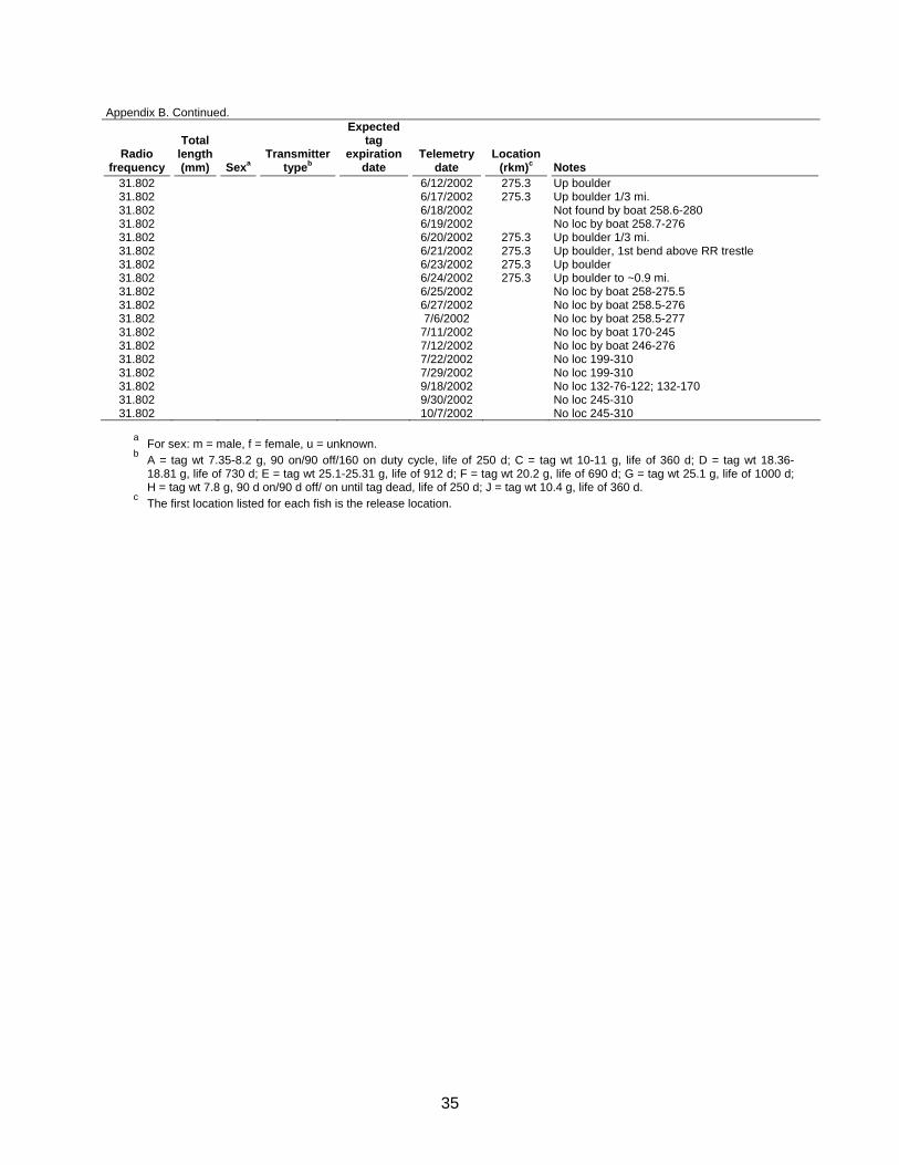
35
Appendix B. Continued.
Radio frequency
Total length (mm) Sexa
Transmitter typeb
Expected tag
expiration date
Telemetry date
Location (rkm)c Notes
31.802 6/12/2002 275.3 Up boulder 31.802 6/17/2002 275.3 Up boulder 1/3 mi. 31.802 6/18/2002 Not found by boat 258.6-280 31.802 6/19/2002 No loc by boat 258.7-276 31.802 6/20/2002 275.3 Up boulder 1/3 mi. 31.802 6/21/2002 275.3 Up boulder, 1st bend above RR trestle 31.802 6/23/2002 275.3 Up boulder 31.802 6/24/2002 275.3 Up boulder to ~0.9 mi. 31.802 6/25/2002 No loc by boat 258-275.5 31.802 6/27/2002 No loc by boat 258.5-276 31.802 7/6/2002 No loc by boat 258.5-277 31.802 7/11/2002 No loc by boat 170-245 31.802 7/12/2002 No loc by boat 246-276 31.802 7/22/2002 No loc 199-310 31.802 7/29/2002 No loc 199-310 31.802 9/18/2002 No loc 132-76-122; 132-170 31.802 9/30/2002 No loc 245-310 31.802 10/7/2002 No loc 245-310
a For sex: m = male, f = female, u = unknown. b A = tag wt 7.35-8.2 g, 90 on/90 off/160 on duty cycle, life of 250 d; C = tag wt 10-11 g, life of 360 d; D = tag wt 18.36-
18.81 g, life of 730 d; E = tag wt 25.1-25.31 g, life of 912 d; F = tag wt 20.2 g, life of 690 d; G = tag wt 25.1 g, life of 1000 d; H = tag wt 7.8 g, 90 d on/90 d off/ on until tag dead, life of 250 d; J = tag wt 10.4 g, life of 360 d.
c The first location listed for each fish is the release location.
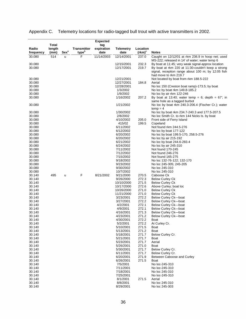
36
Appendix C. Telemetry locations for radio-tagged bull trout with active transmitters in 2002.
Radio frequency
Total length (mm) Sexa
Transmitter typeb
Expected tag
expiration date
Telemetry date
Location (rkm)c Notes
30.080 514 u F 11/14/2003 12/14/2001 237.0 Caught on 12/12/01 at rkm 236.9 in hoop net; used MS-222; released in 14' of water; water temp 6
30.080 12/15/2001 232.3 By boat at 11:45; very weak signal-approx location 30.080 12/17/2001 219.7 By boat at rkm 220 at 11:30-couldn't keep a strong
signal, reception range about 100 m; by 12:05 fish had move to rkm 219.7
30.080 12/21/2001 Not located by boat from rkm 188.5-222 30.080 12/27/2001 184.8 Aerial 30.080 12/28/2001 No loc 150 (Creston boat ramp)-173.5; by boat 30.080 1/3/2002 No loc by boat rkm 149.8-185.2 30.080 1/9/2002 No loc by air rkm 122-246 30.080 1/16/2002 207.2 By boat at 13:40; water temp = 6; depth = 67'; in
same hole as a tagged burbot 30.080 1/21/2002 No loc by boat rkm 240.3-206.4 (Fischer Cr.); water
temp = 4 30.080 1/30/2002 No loc by boat rkm 234.7-240.3 and 177.5-207.5 30.080 2/8/2002 No loc Smith Cr. to rkm 144 Nicks Is. by boat 30.080 4/10/2002 205.0 Front side of Ferry Island 30.080 415/02 199.5 Copeland 30.080 6/11/2002 Not found rkm 244.5-276 30.080 6/12/2002 No loc by boat 177-122 30.080 6/20/2002 No loc by boat 199.5-170, 258.5-276 30.080 6/20/2002 No loc by air 215-192 30.080 6/21/2002 No loc by boat 244.6-283.4 30.080 6/24/2002 No loc by air 245-310 30.080 7/11/2002 Not found 170-245 30.080 7/12/2002 Not found 246-276 30.080 7/15/2002 Not found 165-275 30.080 9/18/2002 No loc 132-76-122; 132-170 30.080 9/23/2002 No loc 245-305; 245-205 30.080 9/30/2002 No loc 245-310 30.080 10/7/2002 No loc 245-310 30.140 495 u F 8/21/2002 9/21/2000 270.5 Caboose Ck 30.140 9/26/2000 272.3 Below Curley Ck 30.140 10/10/2000 271.5 Below Curley Ck 30.140 10/17/2000 272.6 Above Curley; boat loc 30.140 10/26/2000 271.0 Below Curley Ck 30.140 11/21/2000 271.0 Below Curley Ck 30.140 3/23/2001 272.2 Below Curley Ck—boat 30.140 3/27/2001 272.2 Below Curley Ck—boat 30.140 4/2/2001 272.1 Below Curley Ck—boat 30.140 4/9/2001 272.1 Below Curley Ck—boat 30.140 4/16/2001 271.3 Below Curley Ck—boat 30.140 4/23/2001 271.2 Below Curley Ck—boat 30.140 4/30/2001 272.2 Boat 30.140 5/2/2001 272.2 At Curley Cr. 30.140 5/10/2001 271.5 Boat 30.140 5/13/2001 271.2 Boat 30.140 5/18/2001 271.7 Below Curley Cr. 30.140 5/21/2001 271.7 Boat 30.140 5/23/2001 271.7 Aerial 30.140 5/26/2001 271.0 Boat 30.140 5/30/2001 271.7 Below Curley Cr. 30.140 6/11/2001 271.7 Below Curley Cr. 30.140 6/20/2001 271.9 Between Caboose and Curley 30.140 6/26/2001 271.5 Boat 30.140 7/5/2001 No loc-245-310 30.140 7/11/2001 No loc-245-310 30.140 7/18/2001 No loc 245-310 30.140 7/25/2001 No loc-245-310 30.140 8/1/2001 271.5 Aerial 30.140 8/8/2001 No loc 245-310 30.140 8/29/2001 No loc 245-303
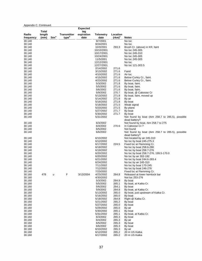
37
Appendix C. Continued.
Radio frequency
Total length (mm) Sexa
Transmitter typeb
Expected tag
expiration date
Telemetry date
Location (rkm)c Notes
30.140 9/7/2001 No loc 30.140 9/24/2001 No loc 30.140 10/3/2001 293.3 Brush Cr. (above) in KR, faint 30.140 10/10/2001 No loc 245-305 30.140 10/17/2001 No loc 245-310 30.140 10/24/2001 No loc 245-305 30.140 11/5/2001 No loc 245-305 30.140 12/12/2001 No loc 30.140 12/27/2001 No loc 121-303.5 30.140 2/14/2002 271.6 30.140 3/13/2002 271.6 Faint! 30.140 4/10/2002 271.6 Air loc 30.140 4/15/2002 271.6 Below Curley Cr., faint. 30.140 4/23/2002 271.6 Below Curley Cr., faint. 30.140 5/3/2002 271.8 By boat, faint. 30.140 5/5/2002 271.6 By boat, faint. 30.140 5/6/2002 271.6 By boat, faint. 30.140 5/9/2002 270.7 By boat, @ Caboose Cr 30.140 5/13/2002 271.8 By boat, faint, moved up 30.140 5/14/2002 271.8 By air 30.140 5/16/2002 271.8 By boat 30.140 5/18/2002 271.5 Weak signal 30.140 5/23/2002 271.5 By plane 30.140 5/27/2002 271.7 By boat 30.140 5/30/2002 271.7 By boat 30.140 5/31/2002 Not found by boat (rkm 258.7 to 285.5), possible
dead battery? 30.140 6/3/2002 Not found by boat, rkm 258.7 to 275 30.140 6/4/2002 270.6 In Caboose Cr.? 30.140 6/5/2002 Not found 30.140 6/6/2002 Not found by boat (rkm 258.7 to 285.5), possible
dead battery? 30.140 6/10/2002 Not located by air 245-310 30.140 6/12/2002 No loc by boat 245-275.3 30.140 6/17/2002 224.5 Fixed loc at Flemming Cr. 30.140 6/18/2002 No loc by boat 258.6-280 30.140 6/19/2002 No loc by boat 258.7-276 30.140 6/20/2002 No loc by boat 258.7-276, 199.5-170.0 30.140 6/20/2002 No loc by air 302-192 30.140 6/21/2002 No loc by boat 244.6-283.4 30.140 6/24/2002 No loc by air 245-310 30.140 7/11/2002 No loc by boat 170-245 30.140 7/12/2002 No loc by boat 246-276 30.140 7/23/2002 Fixed loc at Flemming Cr. 30.160 478 u F 3/13/2004 4/23/2002 264.8 Released at lower hemlock bar 30.160 4/30/2002 Not loc 253-276 30.160 5/3/2002 264.9 By boat 30.160 5/5/2002 265.1 By boat, at Katka Cr. 30.160 5/6/2002 264.1 By boat 30.160 5/9/2002 264.8 By boat, at Katka Cr. 30.160 5/13/2002 265.0 By boat, just upstream of Katka Cr. 30.160 5/16/2002 265.0 By boat 30.160 5/18/2002 264.8 Right @ Katka Cr. 30.160 5/21/2002 265.2 By boat 30.160 5/27/2002 265.0 By boat 30.160 5/29/2002 265.0 By air 30.160 5/30/2002 265.1 By boat 30.160 5/31/2002 265.1 By boat, at Katka Cr. 30.160 6/3/2002 265.3 By boat 30.160 6/4/2002 265.3 By air 30.160 6/5/2002 265.3 By boat 30.160 6/6/2002 265.3 By boat 30.160 6/10/2002 265.3 By air 30.160 6/12/2002 265.2 20 m US Katka 30.160 6/17/2002 265.2 20 m US Katka

38
Appendix C. Continued.
Radio frequency
Total length (mm) Sexa
Transmitter typeb
Expected tag
expiration date
Telemetry date
Location (rkm)c Notes
30.160 6/18/2002 265.2 20 m US Katka 30.160 6/19/2002 265.2 20 m US Katka 30.160 6/20/2002 265.2 20 m US Katka 30.160 6/24/2002 265.2 20 m US Katka 30.160 6/27/2002 265.2 20 m US Katka 30.160 7/1/2002 264.9 Near Katka 30.160 7/3/2002 264.9 At mouth of Katka Cr. 30.160 7/6/2002 265.3 50 m upstream of Katka Cr. 30.160 7/10/2002 264.9 At mouth of Katka Cr. 30.160 7/15/2002 264.9 Near Katka 30.160 7/22/2002 264.9 Near Katka 30.160 7/23/2002 265.3 By boat 30.160 7/25/2002 267.7 Moved upriver 30.160 7/26/2002 268.0 Moved upriver 30.160 7/29/2002 268.0 Below Debt 30.160 7/31/2002 265.2 Moved downriver 30.160 8/3/2002 265.2 Same 30.160 8/5/2002 273.5 Up below boulder 30.160 8/12/2002 265.3 Above Katka 30.160 8/19/2002 265.3 Above Katka 30.160 8/22/2002 No loc by boat 30.160 8/26/2002 264.5 Below Katka 30.160 9/3/2002 264.5 Below Katka 30.160 9/9/2002 264.5 Below Katka 30.160 9/16/2002 264.5 Below Katka 30.160 9/23/2002 264.5 Below Katka 30.160 9/30/2002 264.5 Below Katka 30.160 10/7/2002 264.5 Below Katka 30.160 10/15/2002 264.5 Below Katka 30.160 10/21/2002 264.5 Below Katka 30.160 11/4/2002 264.5 Below Katka 30.160 12/3/2002 264.5 Below Katka 30.191 800 m D 10/8/2001 10/8/1999 301.2 Capt @ O’Brien 30.191 10/14/1999 304.8 Throop Lake 30.191 10/19/1999 305.1 Throop Lake; weak signal 30.191 10/26/1999 305.1 Throop Lake; weak signal 30.191 11/1/1999 305.8 Upstream from Throop L 30.191 11/9/1999 305.8 Upstream from Throop L 30.191 11/29/1999 304.5 Throop Lake 30.191 12/14/1999 304.5 Throop Lake 30.191 1/18/2000 304.7 Dwnstrm end of island 30.191 2/15/2000 304.7 Dwnstrm end of island 30.191 3/21/2000 304.7 Dwnstrm end of island 30.191 4/11/2000 305.1 Upstream end of island 30.191 4/24/2000 305.1 Upstream end of island 30.191 5/2/2000 305.1 Upstream end of island 30.191 5/9/2000 305.2 Upstream end of island 30.191 5/16/2000 305.2 Upstream end of island 30.191 5/23/2000 305.2 Upstream end of island 30.191 5/30/2000 305.2 Upstream end of island 30.191 6/6/2000 305.2 Upstream end of island 30.191 6/20/2000 No location 30.191 6/28/2000 307.5 Moved into canyon 30.191 7/5/2000 305.1 Upstream end of island 30.191 7/11/2000 309.5 Into canyon 30.191 7/18/2000 305.1 Upstream end of island 30.191 8/1/2000 305.1 Upstream end of island 30.191 8/8/2000 305.1 Upstream end of island 30.191 8/15/2000 305.1 Upstream end of island 30.191 8/22/2000 305.1 Upstream end of island 30.191 8/29/2000 305.1 Upstream end of island 30.191 9/5/2000 305.1 Upstream end of island 30.191 9/12/2000 305.1 Upstream end of island 30.191 9/26/2000 305.1 Upstream end of island 30.191 10/26/2000 304.7 Dwnstrm end of island

39
Appendix C. Continued.
Radio frequency
Total length (mm) Sexa
Transmitter typeb
Expected tag
expiration date
Telemetry date
Location (rkm)c Notes
30.191 11/21/2000 304.7 Dwnstrm end of island 30.191 1/4/2001 304.7 30.191 3/28/2001 304.7 Dwnstrm end of island 30.191 4/11/2001 304.7 Dwnstrm end of island 30.191 4/18/2001 304.7 Dwnstrm end of island 30.191 4/25/2001 304.7 Dwnstrm end of island 30.191 5/18/2001 304.7 Dwnstrm end of island 30.191 5/30/2001 304.7 Dwnstrm end of island 30.191 6/11/2001 304.7 Dwnstrm end of island 30.191 7/5/2001 308.5 Into canyon 30.191 7/11/2001 309.7 Top of K. Falls 30.191 7/18/2001 309.7 Same 30.191 7/25/2001 309.7 Top of K. Falls 30.191 8/1/2001 309.7 Top of K. Falls 30.191 8/8/2001 301.2 Down river to confluence of O'Brien 30.191 8/16/2001 301.1 Slightly below O'Brien 30.191 8/22/2001 301.1 Slightly below O'Brien- good signal 30.191 8/29/2001 301.0 Slightly below O'Brien 30.191 9/7/2001 301.0 Slightly below O'Brien 30.191 9/24/2001 300.1 Below O'Brien, good signal 30.191 10/3/2001 300.1 Below O'Brien, good signal 30.191 10/10/2001 300.3 @ Lake Cr 30.191 10/17/2001 300.3 @ Lake Cr 30.191 10/24/2001 300.3 Below O'Brien, good signal 30.191 11/5/2001 300.3 Below O'Brien, good signal 30.191 12/12/2001 303.5 Moved above bend 30.191 12/27/2001 303.5 Above bend 30.191 2/14/2002 303.5 Above bend 30.191 3/13/2002 303.5 Above bend 30.191 4/10/2002 303.5 Above bend 30.191 4/15/2002 303.5 Above bend 30.191 4/23/2002 303.5 Above bend 30.191 5/23/2002 303.5 Above bend 30.191 6/4/2002 303.5 Above bend 30.191 6/10/2002 303.5 Above bend 30.191 6/24/2002 303.5 Above bend 30.191 7/1/2002 307.3 Up to canyon 30.191 7/15/2002 305.2 @ House 30.191 7/22/2002 304.5 Down from O’Brien 30.191 7/29/2002 299.3 @ Callahan confluence 30.191 8/5/2002 301.0 @ O’Brien 30.191 8/12/2002 301.0 @ O’Brien 30.191 8/19/2002 Gone? Off? 30.191 8/26/2002 301.2 Just upstream of O’Brien 30.191 9/3/2002 304.0 Upriver ~3 rkm 30.191 9/16/2002 304.0 In KR, faint 30.191 9/23/2002 304.0 In KR, faint 30.191 9/30/2002 304.0 In KR, faint 30.191 10/7/2002 304.0 In KR, faint 30.191 10/15/2002 304.0 In KR, faint 30.191 10/21/2002 304.0 In KR, faint 30.191 11/4/2002 304.0 In KR, faint 30.191 12/5/2002 304.0 In KR, faint 30.231 595 u G 12/1/2003 3/6/2001 244.5 Captured in hoop net on 3/5 at Ambush Rock; used
clove oil-fish "knocked out" quick and recovered quick (within 1 min.); did well during surgery (no movement, consistent gilling); swam away-looked healthy; stitched muscle layer together (w/ prolene), then stitched skin together. No bleeding
30.231 3/9/2001 Not located-searched near release point only-rkm 244.5
30.231 3/14/2001 Not located 30.231 3/22/2001 Not located-searched near release point only-rkm
244.5 30.231 3/28/2001 Not located—aerial, 305-122

40
Appendix C. Continued.
Radio frequency
Total length (mm) Sexa
Transmitter typeb
Expected tag
expiration date
Telemetry date
Location (rkm)c Notes
30.231 4/11/2001 Not located—aerial, 305-122 30.231 4/18/2001 Not located—aerial, 305-170 30.231 4/25/2001 Not located—aerial, 170-310 30.231 5/2/2001 Not located—aerial, 150-285 and Deep Cr. 30.231 5/9/2001 132.0 Near E. Channel 30.231 5/31/2001 131.5 Bend below E. Channel 30.231 7/18/2001 131.5 Bend below E. Channel 30.231 12/27/2001 131.8 Approx. location 30.231 2/13/2002 131.5 Bend below E. Channel 30.231 4/15/2002 131.5 Bend below E. Channel 30.231 6/12/2002 No loc by boat 177-122 30.231 6/20/2002 No loc by boat 199.5-170, 258.5-276 30.231 7/3/2002 131.8 By air 30.231 7/11/2002 No loc by boat 170-245 30.231 7/12/2002 No loc by boat 245-276 30.231 7/15/2002 131.8 By air 30.231 8/16/2002 131.8 By air 30.231 9/18/2002 131.5 By air 30.241 459 u D 9/15/2001 9/15/1999 262.5 Capt @ Hemlock Bar 30.241 9/17/1999 264.1 Powerline above bar 30.241 9/21/1999 262.0 @ bend below Hemlock Bar 30.241 9/28/1999 262.0 Bend below Hemlock Bar 30.241 10/5/1999 262.0 Bend below Hemlock Bar 30.241 10/14/1999 262.0 Bend below Hemlock Bar 30.241 10/19/1999 262.0 Bend below Hemlock Bar 30.241 10/26/1999 262.0 Bend below Hemlock Bar 30.241 11/1/1999 262.0 Bend below Hemlock Bar 30.241 11/9/1999 262.5 @ Hemlock Bar 30.241 11/29/1999 262.5 @ Hemlock Bar 30.241 12/14/1999 262.0 Bend below Hemlock Bar 30.241 1/18/2000 262.0 Bend below Hemlock Bar 30.241 2/15/2000 262.0 Bend below Hemlock Bar 30.241 3/21/2000 262.0 Bend below Hemlock Bar 30.241 4/11/2000 262.0 Bend below Hemlock Bar 30.241 4/24/2000 262.0 Bend below Hemlock Bar 30.241 5/2/2000 262.2 Bend below Hemlock Bar 30.241 5/9/2000 262.0 Bend below Hemlock Bar 30.241 5/16/2000 262.0 Bend below Hemlock Bar 30.241 5/23/2000 262.0 Bend below Hemlock Bar 30.241 5/30/2000 262.0 Bend below Hemlock Bar 30.241 6/6/2000 262.0 Bend below Hemlock Bar 30.241 6/13/2000 262.0 Bend below Hemlock Bar 30.241 6/20/2000 262.0 Bend below Hemlock Bar 30.241 6/28/2000 262.0 Bend below Hemlock Bar 30.241 6/30/2000 262.0 Bend below Hemlock Bar 30.241 7/5/2000 262.0 Bend below Hemlock Bar 30.241 7/11/2000 276.1 Above Leonia Bridge 30.241 7/18/2000 301.2 O’Brien Ck confluence-in KR 30.241 8/1/2000 301.2 O’Brien Ck confluence-in KR 30.241 8/8/2000 301.2 O’Brien Ck confluence-in KR 30.241 8/15/2000 301.2 O’Brien Ck confluence-in KR 30.241 8/22/2000 301.2 O’Brien Ck confluence-in KR 30.241 8/29/2000 300.3 Below O’Brien Ck confluence 30.241 9/5/2000 300.3 Below O’Brien Ck confluence 30.241 9/12/2000 294.4 Just above hwy bridge 30.241 9/26/2000 293.2 Brush Ck, in KR 30.241 10/10/2000 293.2 Brush Ck, in KR 30.241 10/26/2000 293.2 Brush Ck, in KR 30.241 11/21/2000 293.2 Brush Ck, in KR 30.241 1/4/2001 265.0 Bend below Hemlock Bar 30.241 3/23/2001 262.0 Boat 30.241 3/27/2001 262.1 Boat 30.241 4/2/2001 262.0 Boat 30.241 4/9/2001 262.0 Boat 30.241 4/11/2001 264.5
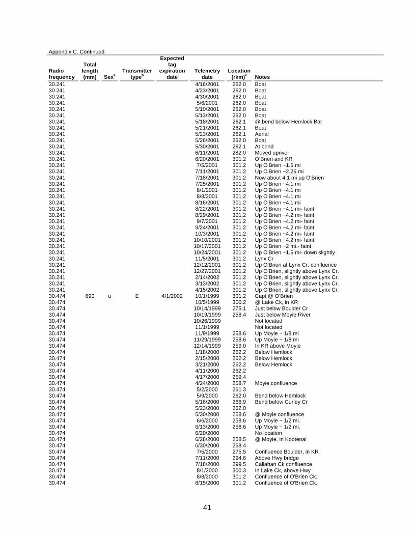
41
Appendix C. Continued.
Radio frequency
Total length (mm) Sexa
Transmitter typeb
Expected tag
expiration date
Telemetry date
Location (rkm)c Notes
30.241 4/16/2001 262.0 Boat 30.241 4/23/2001 262.0 Boat 30.241 4/30/2001 262.0 Boat 30.241 5/6/2001 262.0 Boat 30.241 5/10/2001 262.0 Boat 30.241 5/13/2001 262.0 Boat 30.241 5/18/2001 262.1 @ bend below Hemlock Bar 30.241 5/21/2001 262.1 Boat 30.241 5/23/2001 262.1 Aerial 30.241 5/26/2001 262.0 Boat 30.241 5/30/2001 262.1 At bend 30.241 6/11/2001 282.0 Moved upriver 30.241 6/20/2001 301.2 O’Brien and KR 30.241 7/5/2001 301.2 Up O'Brien ~1.5 mi 30.241 7/11/2001 301.2 Up O'Brien ~2.25 mi 30.241 7/18/2001 301.2 Now about 4.1 mi up O'Brien 30.241 7/25/2001 301.2 Up O'Brien ~4.1 mi 30.241 8/1/2001 301.2 Up O'Brien ~4.1 mi 30.241 8/8/2001 301.2 Up O'Brien ~4.1 mi 30.241 8/16/2001 301.2 Up O'Brien ~4.1 mi 30.241 8/22/2001 301.2 Up O'Brien ~4.1 mi- faint 30.241 8/29/2001 301.2 Up O'Brien ~4.2 mi- faint 30.241 9/7/2001 301.2 Up O'Brien ~4.2 mi- faint 30.241 9/24/2001 301.2 Up O'Brien ~4.2 mi- faint 30.241 10/3/2001 301.2 Up O'Brien ~4.2 mi- faint 30.241 10/10/2001 301.2 Up O'Brien ~4.2 mi- faint 30.241 10/17/2001 301.2 Up O'Brien ~2 mi.- faint 30.241 10/24/2001 301.2 Up O'Brien ~1.5 mi- down slightly 30.241 11/5/2001 301.2 Lynx Cr 30.241 12/12/2001 301.2 Up O’Brien at Lynx Cr. confluence 30.241 12/27/2001 301.2 Up O’Brien, slightly above Lynx Cr. 30.241 2/14/2002 301.2 Up O’Brien, slightly above Lynx Cr. 30.241 3/13/2002 301.2 Up O’Brien, slightly above Lynx Cr. 30.241 4/15/2002 301.2 Up O’Brien, slightly above Lynx Cr. 30.474 690 u E 4/1/2002 10/1/1999 301.2 Capt @ O’Brien 30.474 10/5/1999 300.2 @ Lake Ck, in KR 30.474 10/14/1999 275.1 Just below Boulder Cr 30.474 10/19/1999 258.4 Just below Moyie River 30.474 10/26/1999 Not located 30.474 11/1/1999 Not located 30.474 11/9/1999 258.6 Up Moyie ~ 1/8 mi 30.474 11/29/1999 258.6 Up Moyie ~ 1/8 mi 30.474 12/14/1999 259.0 In KR above Moyie 30.474 1/18/2000 262.2 Below Hemlock 30.474 2/15/2000 262.2 Below Hemlock 30.474 3/21/2000 262.2 Below Hemlock 30.474 4/11/2000 262.2 30.474 4/17/2000 259.4 30.474 4/24/2000 258.7 Moyie confluence 30.474 5/2/2000 261.3 30.474 5/9/2000 262.0 Bend below Hemlock 30.474 5/16/2000 266.9 Bend below Curley Cr 30.474 5/23/2000 262.0 30.474 5/30/2000 258.6 @ Moyie confluence 30.474 6/6/2000 258.6 Up Moyie ~ 1/2 mi. 30.474 6/13/2000 258.6 Up Moyie ~ 1/2 mi. 30.474 6/20/2000 No location 30.474 6/28/2000 258.5 @ Moyie, in Kootenai 30.474 6/30/2000 268.4 30.474 7/5/2000 275.5 Confluence Boulder, in KR 30.474 7/11/2000 294.6 Above Hwy bridge 30.474 7/18/2000 299.5 Callahan Ck confluence 30.474 8/1/2000 300.3 In Lake Ck, above Hwy 30.474 8/8/2000 301.2 Confluence of O'Brien Ck. 30.474 8/15/2000 301.2 Confluence of O'Brien Ck.
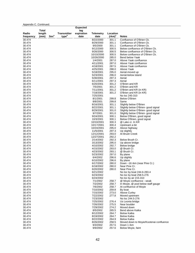
42
Appendix C. Continued.
Radio frequency
Total length (mm) Sexa
Transmitter typeb
Expected tag
expiration date
Telemetry date
Location (rkm)c Notes
30.474 8/22/2000 301.1 Confluence of O'Brien Ck. 30.474 8/29/2000 301.1 Confluence of O'Brien Ck. 30.474 9/5/2000 301.1 Confluence of O'Brien Ck. 30.474 9/12/2000 300.5 Below confluence of O'Brien Ck. 30.474 9/26/2000 300.5 Below confluence of O'Brien Ck. 30.474 10/10/2000 300.5 Below confluence of O'Brien Ck. 30.474 10/26/2000 285.0 Bend below Yaak 30.474 1/4/2001 287.0 Above Yaak confluence 30.474 4/11/2001 287.0 Above Yaak confluence 30.474 4/18/2001 287.5 Above Yaak confluence 30.474 4/25/2001 288.0 Above Yaak 30.474 5/18/2001 295.0 Aerial-moved up 30.474 5/23/2001 296.0 Aerial-below island 30.474 5/30/2001 297.3 Aerial 30.474 6/11/2001 297.3 Aerial 30.474 6/20/2001 301.2 O’Brien and KR 30.474 7/5/2001 301.2 O'Brien and KR 30.474 7/11/2001 301.2 O'Brien and KR (in KR) 30.474 7/18/2001 301.2 O'Brien and KR (in KR) 30.474 7/25/2001 No loc 245-310 30.474 8/1/2001 299.8 Below O'Brien 30.474 8/8/2001 299.8 Same 30.474 8/16/2001 301.1 Slightly below O'Brien 30.474 8/22/2001 301.1 Slightly below O'Brien- good signal 30.474 8/29/2001 301.0 Slightly below O'Brien- good signal 30.474 9/7/2001 301.0 Slightly below O'Brien- good signal 30.474 9/24/2001 300.1 Below O'Brien, good signal 30.474 10/3/2001 300.1 Below O'Brien, good signal 30.474 10/10/2001 300.3 @ Lake cr. In KR 30.474 10/17/2001 300.4 Upstream a bit 30.474 10/24/2001 295.0 Above highway 30.474 11/5/2001 297.3 Up slightly 30.474 12/12/2001 293.0 At Brush Creek 30.474 12/27/2001 292.2 30.474 2/14/2002 292.3 Below Brush Cr. 30.474 3/13/2002 295.0 Up above bridge 30.474 4/10/2002 292.7 Below bridge 30.474 4/15/2002 293.0 @ Brush Cr. 30.474 4/23/2002 293.1 @ Brush Cr. 30.474 5/23/2002 297.0 By plane 30.474 6/4/2002 296.6 Up slightly 30.474 6/10/2002 296.6 By plane 30.474 6/17/2002 280.0 Down ~16 rkm (near Pine Cr.) 30.474 6/18/2002 280.0 Near Pine Cr. 30.474 6/20/2002 280.0 Near Pine Cr. 30.474 6/21/2002 No loc by boat 244.6-283.4 30.474 6/23/2002 No loc by boat 258.5-276 30.474 6/24/2002 No loc by air 215-310 30.474 7/1/2002 258.7 @ Moyie confluence - weak 30.474 7/2/2002 258.7 In Moyie, @ pool below staff gauge 30.474 7/6/2002 258.7 At confluence of Moyie 30.474 7/10/2002 259.8 By boat 30.474 7/15/2002 273.0 Above Curley 30.474 7/22/2002 277.8 Moved upstream 30.474 7/23/2002 No loc 244.5-276 30.474 7/25/2002 276.4 Us Leonia bridge 30.474 7/26/2002 275.5 Near boulder 30.474 7/29/2002 274.2 Moved down 30.474 8/5/2002 265.5 Bend above Katka 30.474 8/12/2002 264.7 Below Katka 30.474 8/19/2002 264.7 Below Katka 30.474 8/22/2002 264.9 Below Katka 30.474 8/26/2002 258.5 Moved down to Moyie/Kootenai confluence 30.474 9/3/2002 257.5 Down 1 rkm 30.474 9/9/2002 257.6 Below Moyie, faint

43
Appendix C. Continued.
Radio frequency
Total length (mm) Sexa
Transmitter typeb
Expected tag
expiration date
Telemetry date
Location (rkm)c Notes
30.474 9/16/2002 258.7 Just in Moyie 30.474 9/23/2002 258.7 @ KR & Moyie confluence 30.474 9/30/2002 258.3 Dwnstrm 30.474 10/7/2002 258.3 Same 30.474 10/15/2002 258.3 Same 30.474 10/21/2002 258.3 30.474 11/4/2002 258.3 Same 30.474 12/3/2002 258.6 Actual date unknown, radio tag found on shore at
mouth of Moyie River sometime between 11/4 and 12/3
31.033 581 u G 11/14/2003 3/14/2001 221.5 Captured in hoop net on 3/12/01; approx. 15 min or so to "knock out" (used clove oil); was gilling pretty slow at start of surgery; sutured muscle layer w/ dissolvable sutures, then skin layer with prolene, some bleeding; fish recovered (i.e. trying to swim in tank) in about 3 (?) min; swam off fine after release.
31.033 3/22/2001 221.5 31.033 3/28/2001 228.5 Lower Shortys Is. 31.033 4/11/2001 228.0 Lower Shortys Is. 31.033 4/18/2001 228.3 Lower Shortys Is. 31.033 4/25/2001 226.5 Stretch above Flemming 31.033 5/9/2001 221.0 Fischer Creek 31.033 5/31/2001 221.0 Fisher Creek 31.033 6/11/2001 225.0 Flemming 31.033 6/20/2001 250.0 West of Crossport 31.033 7/5/2001 301.2 Up O'Brien ~0.1 km 31.033 7/11/2001 301.1 In KR below confluence O'Brien 31.033 7/18/2001 301.2 Appears to be about 800 ft up O'Brien Cr. 31.033 7/25/2001 301.1 In KR below confluence O'Brien 31.033 8/1/2001 301.0 In KR below confluence O'Brien 31.033 8/8/2001 301.0 In KR below confluence O'Brien 31.033 8/16/2001 301.0 In KR below confluence O'Brien 31.033 8/22/2001 301.1 In KR below confluence O'Brien- good signal 31.033 8/29/2001 301.1 In KR below confluence O'Brien 31.033 9/7/2001 301.2 Up O'Brien ~0.1 km 31.033 9/24/2001 301.2 Up O'Brien ~1.1 km 31.033 10/3/2001 301.2 Up O'Brien ~0.1 km 31.033 10/10/2001 293.3 @ Brush Cr in KR 31.033 10/17/2001 289.5 Downstream 31.033 10/24/2001 290.0 Up slightly 31.033 11/5/2001 290.0 Same 31.033 12/12/2001 287.5 Above Yaak 31.033 12/27/2001 289.5 31.033 2/14/2002 289.5 31.033 3/13/2002 289.5 31.033 4/10/2002 289.5 By air 31.033 4/15/2002 289.1 Above Yaak 31.033 4/23/2002 287.9 31.033 5/23/2002 289.1 By plane 31.033 6/4/2002 289.1 Just below ruby 31.033 6/10/2002 289.1 Just below ruby 31.033 6/17/2002 258.6 In Moyie 1/8 mi. up 31.033 6/18/2002 258.6 In Moyie 1/8 mi. up 31.033 6/19/2002 258.6 In Moyie 1/8 mi. up 31.033 6/20/2002 258.6 @ Moyie confluence 31.033 6/21/2002 257.4 Also had ang signal at the Powerline 257.7 31.033 6/23/2002 259.0 By boat, moved up 31.033 6/24/2002 258.5 @ Moyie confluence 31.033 6/25/2002 258.7 @ Moyie confluence 31.033 6/27/2002 258.7 @ Moyie confluence 31.033 7/1/2002 258.7 @ Moyie confluence 31.033 7/2/2002 258.7 @ Moyie confluence 31.033 7/3/2002 258.8 In front of Vick's house 31.033 7/6/2002 258.7 At confluence of Moyie 31.033 7/10/2002 258.7 By boat
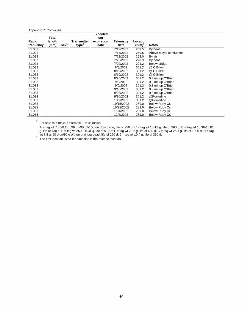
44
Appendix C. Continued.
Radio frequency
Total length (mm) Sexa
Transmitter typeb
Expected tag
expiration date
Telemetry date
Location (rkm)c Notes
31.033 7/12/2002 259.5 By boat 31.033 7/15/2002 259.5 Above Moyie confluence 31.033 7/22/2002 263.0 By air 31.033 7/23/2002 270.3 By boat 31.033 7/29/2002 294.2 Below bridge 31.033 8/5/2002 301.2 @ O’Brien 31.033 8/12/2002 301.2 @ O’Brien 31.033 8/19/2002 301.2 @ O’Brien 31.033 8/26/2002 301.2 0.3 mi. up O’Brien 31.033 9/3/2002 301.2 0.3 mi. up O’Brien 31.033 9/9/2002 301.2 0.3 mi. up O’Brien 31.033 9/16/2002 301.2 0.3 mi. up O’Brien 31.033 9/23/2002 301.2 0.3 mi. up O’Brien 31.033 9/30/2002 301.2 @Powerline 31.033 10/7/2002 301.2 @Powerline 31.033 10/15/2002 289.0 Below Ruby Cr. 31.033 10/21/2002 289.0 Below Ruby Cr. 31.033 11/4/2002 289.0 Below Ruby Cr. 31.033 12/5/2002 289.0 Below Ruby Cr.
a For sex: m = male, f = female, u = unknown. b A = tag wt 7.35-8.2 g, 90 on/90 off/160 on duty cycle, life of 250 d; C = tag wt 10-11 g, life of 360 d; D = tag wt 18.36-18.81
g, life of 730 d; E = tag wt 25.1-25.31 g, life of 912 d; F = tag wt 20.2 g, life of 690 d; G = tag wt 25.1 g, life of 1000 d; H = tag wt 7.8 g, 90 d on/90 d off/ on until tag dead, life of 250 d; J = tag wt 10.4 g, life of 360 d.
c The first location listed for each fish is the release location.
45
Prepared by: Approved by: IDAHO DEPARTMENT OF FISH AND GAME Jody P. Walters Virgil K. Moore, Chief Senior Fishery Research Biologist Bureau of Fisheries Daniel J. Schill Fisheries Research Manager


![2015-2016 Implementation Manual - BPA.gov · 2017. 6. 16. · VI | Section 1: Introduction [April 1, 2016] BONNEVILLE POWER ADMINISTRA TION Changes & Corrections Summary Introduction](https://img.dokumen.tips/doc/110x75/5ff0ab4db9dba44625690cd6/2015-2016-implementation-manual-bpagov-2017-6-16-vi-section-1-introduction.jpg)