Embed Size (px)
Citation preview

U.S. Department of the Interior State of Washington Bureau of Reclamation Department of Ecology Pacific Northwest Region Office of Columbia River Columbia-Cascades Area Office Yakima, Washington Yakima, Washington December 2014
Bull Trout Enhancement
Kachess Drought Relief Pumping Plant and Keechelus-To-Kachess Conveyance Kittitas and Yakima Counties, Washington A Component of the Yakima River Basin Integrated Water Resource Management Plan

Mission Statements
The U.S. Department of the Interior protects America’s natural resources and heritage, honors our cultures and tribal communities, and supplies the energy to power our future. The mission of the Bureau of Reclamation is to manage, develop, and protect water and related resources in an environmentally and economically sound manner in the interest of the American public. The mission of the Department of Ecology is to protect, preserve and enhance Washington’s environment, and promote the wise management of our air, land and water for the benefit of current and future generations.
i
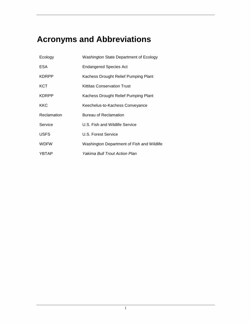
Acronyms and Abbreviations
Ecology Washington State Department of Ecology
ESA Endangered Species Act
KDRPP Kachess Drought Relief Pumping Plant
KCT Kittitas Conservation Trust
KDRPP Kachess Drought Relief Pumping Plant
KKC Keechelus-to-Kachess Conveyance
Reclamation Bureau of Reclamation
Service U.S. Fish and Wildlife Service
USFS U.S. Forest Service
WDFW Washington Department of Fish and Wildlife
YBTAP Yakima Bull Trout Action Plan

ii

iii
Contents Page
CHAPTER 1: INTRODUCTION ............................................................................ 1
CHAPTER 2: POPULATIONS.............................................................................. 2 2.1. Threats ....................................................................................................... 3
2.1.1 Summary of Baseline Threats ............................................................... 5
CHAPTER 3: ENHANCEMENT PROJECTS AND ACTIONS.............................. 6 3.1. Gold Creek Passage and Habitat Improvements ........................................ 6
3.1.1 Gold Creek Actions ............................................................................... 7 3.1.2 Gold Creek Pond Actions ...................................................................... 7 3.1.3 Helis Pond Actions ................................................................................ 9
3.2. Gold Creek USFS Bridge Replacement .................................................... 10 3.3. Cold Creek Passage Improvement ........................................................... 15 3.4. Bull Trout Task Force Project ................................................................... 18 3.5. Kachess River and Box Canyon Creek Assessment and Design ............. 19 3.6. Box Canyon Passage Assessment ........................................................... 22 3.7. South Fork Tieton River Passage Assessment and Design ..................... 22 3.8. Bull Trout Population Enhancement Evaluation ........................................ 24 3.9. Improve Productivity and Food Resources ............................................... 25
CHAPTER 4: SUMMARY OF ANTICIPATED ENHANCEMENT PROJECT BENEFITS AND THREATS ADDRESSED ........................................................ 26
CHAPTER 5: COST FOR PHASE 1 OF THE BULL TROUT ENHANCEMENT PLAN .................................................................................................................. 27
CHAPTER 6: BULL TROUT ENHANCEMENT – PHASE 2 .............................. 28
CHAPTER 7: MEMORANDUM OF UNDERSTANDING .................................... 29
CHAPTER 8: MITIGATION ................................................................................ 29 8.1. Mitigation Measures .................................................................................. 29
CHAPTER 9: MAPS ........................................................................................... 31

iv

1
CHAPTER 1: INTRODUCTION As a component of both the Kachess Drought Relief Pumping Plant (KDRPP) and Keechelus-to-Kachess Conveyance (KKC) projects, the Bureau of Reclamation and Washington State Department of Ecology have identified bull trout enhancement projects to address a need for improving the resiliency of bull trout populations in Keechelus and Kachess watersheds. Individual projects were identified in conjunction with the U.S. Fish and Wildlife Service (Service), National Marine Fisheries Service (NMFS), Washington Department of Fish and Wildlife (WDFW), and the Yakama Nation. The Yakama Nation, Service, WDFW, Ecology, and Reclamation, have entered into a Memorandum of Understanding (MOU) to facilitate coordination and communication concerning bull trout enhancement projects.
In June 1998, the Service listed the Columbia River Basin “distinct population segment” of bull trout as threatened under the Endangered Species Act (ESA). The Service subsequently identified 15 local populations of bull trout in the Yakima Basin (Service 2014) and designated critical habitat in a number of reaches of the Yakima River and tributaries, including portions of the project areas for the KDRPP and KKC projects.
The enhancement projects (on-the-ground work projects) and actions (assessments and design work based on assessments) described herein are intended to complement other proposed measures and best management practices to avoid or reduce adverse effects on aquatic species as part of the KDRPP and KKC. The enhancements also are intended to support the objectives of the Yakima River Basin Integrated Water Resource Management Plan (Integrated Plan; Reclamation and Ecology, 2011) associated with the need to address problems with depleted populations and degraded aquatic habitat. This objective of the Enhancement Package is to improve aquatic conditions within the Keechelus and Kachess watersheds. Bull trout are the focal species for this effort, given both their threatened status under the ESA, and current local-population abundance in these areas. The specific needs of bull trout were therefore used to prioritize activities for inclusion in this plan.
This document summarizes current threats to bull trout in the reservoirs and tributaries of those watersheds and prioritizes specific actions expected to reduce the probability or magnitude of risk posed. The projects described in this document consider both habitat enhancements to improve the function and productivity of reservoir and tributary habitats as well as population enhancement efforts, such as translocation/and or supplementation of bull trout populations in the Yakima Basin. However, the projects described in this document are not intended to represent the full scope of potential restoration and enhancement activities within the upper Yakima Basin.
Phase 1 of the Bull Trout Enhancement Plan includes implementation of four enhancement projects—Gold Creek Passage and Habitat Improvements, Gold Creek U.S. Forest Service (USFS) Bridge Replacement, Cold Creek Passage Improvements, and nutrient enhancement using pathogen-treated fish carcasses. Project assessments (see Chapter 3) are also included in Phase 1 to better prioritize and direct efforts advanced under Phase 2.

2
Phase 2 of the Bull Trout Enhancement Plan includes project implementation based on the results of the assessments and designs prepared in Phase 1 (see Chapter 6).
CHAPTER 2: POPULATIONS A key bull trout characterization is life history strategy. In the Yakima Basin, these strategies include: fluvial, adfluvial, and resident. All individuals, regardless of life history, spawn in cold and pristine headwater tributaries. Juvenile bull trout rear in these natal streams for 2 to 4 years. Resident fish continue to occupy headwater tributaries, but fluvial bull trout migrate downstream to larger rivers and adfluvial bull trout migrate to lakes to rear. These migratory fish live several years in larger rivers or lakes, where they grow to a much larger size than resident forms before returning to tributaries to spawn.
To successfully spawn and rear, bull trout have stringent habitat requirements for water quality, riparian and instream cover, channel stability, and spawning and rearing substrate (Fraley and Shepard 1989; Goetz 1989; Hoelscher and Bjornn 1989; Sedell and Everest 1991; Pratt 1992; Rieman and McIntyre 1993, 1995; Watson and Hillman 1997). These required characteristics are not necessarily present throughout watersheds, even in pristine habitats (Watson and Hillman 1997 and Rieman and McIntyre 1993) resulting in patchy bull trout distribution within a watershed (Rieman et al. 1997). Seasonal habitats for all bull trout life histories are linked through migratory corridors. The ability to migrate is important to the persistence of bull trout (Rieman and McIntyre 1993; Rieman et al. 1997). Migrations also facilitate gene flow among local populations when individuals from different local populations interbreed, stray, or return to non-natal streams. Local populations that are extirpated by catastrophic events may also become reestablished by bull trout migrants.
In the Yakima basin, 9 adfluvial, 4 fluvial, and 2 resident local bull trout populations have been identified (Reiss et al. 2012). All known adfluvial populations are or were located upstream of storage reservoirs. While a fluvial population has been assigned to the Upper Yakima River, there is no evidence that the few spawning fish observed in this area constitute a distinct and self-supporting population. With the potential extirpation of two adfluvial populations in the Cle Elum drainage and the resident population in the Teanaway watershed (Reiss et al. 2012), the three local populations located in the Kachess (Box Canyon and Kachess local populations) and Keechelus (Gold Creek local population) drainages are the only known populations remaining in the Upper Yakima watershed. Each of these populations have critically low abundances, with 10-year geometric means of 8, 11, and 13 redds, respectively (Eric Anderson, Personal Communication, 2014).
Non-natural barriers to passage have reduced or eliminated population movement and the potential for genetic exchange, as well as reducing habitat quality and quantity in migratory corridors (Reiss et al. 2012). According to a comprehensive genetic analysis, bull trout in the Yakima Basin appear to be losing genetic diversity in comparison to bull trout throughout the species’ range in the United States (Small et al. 2009). Results of microsatellite analysis of 462 bull trout samples from the Yakima River Basin indicate limited and asymmetrical gene flow among populations. As population sizes decline, genetic diversity is lost, and the risk of inbreeding increases, and resilience in the face of catastrophic events declines. While there is evidence that small populations have persisted at low numbers for many generations (Whitesel et

3
al. 2004), reduced genetic diversity, combined with current habitat threats are thought to threaten Yakima bull trout population’s long-term viability.
2.1. Threats
Bull trout populations in Keechelus and Kachess reservoirs have chronically low abundance, reduced genetic diversity, and are isolated from other bull trout populations. The presence of reservoir dams has eliminated upstream access to the historic habitat and effectively eliminated opportunities for fluvial (river and stream) migrations and the interaction with other populations within the Yakima Basin. In recognition of this threat, the Integrated Plan includes the Reservoir Fish Passage Element (Reclamation and Ecology, 2011).
In addition, each population has specific threats that are unique to the geographic spawning and rearing habitats within the reservoirs (Tables 1 through 4). Climate change (e.g., Mastin, 2008) adds another layer of risk for Yakima Basin bull trout. The Yakima Bull Trout Action Plan (YBTAP) (Reiss et al. 2012) provides a comprehensive analysis of threats throughout the Yakima watershed).
Table 1. Gold Creek (Keechelus Reservoir) threats, highest severity rating in any life stage/effect category, abbreviated list of associated actions and action priority identified in Yakima Basin Bull Trout Action Plan (Reiss, et al. 2012)
Threats Rating Actions Priority Dewatering SIGNIFICANT Hydrological assessment,
floodplain restoration HIGH
Low abundance SIGNIFICANT Evaluate supplementation HIGH Passage barriers SIGNIFICANT Passage at Keechelus
Dam HIGH
Angling UNKNOWN SIGNIFICANT
Monitor; outreach MEDIUM
Development UNKNOWN SIGNIFICANT
Land acquisition; monitor bank stabilization projects
MEDIUM
Entrainment UNKNOWN SIGNIFICANT
Passage at Keechelus Dam
MEDIUM
Prey base UNKNOWN SIGNIFICANT
Carcass/analogs MEDIUM
Introduced species UNKNOWN Monitor brook trout introgression
MEDIUM
Transportation UNKNOWN LOW LOW Forest management LOW LOW Recreation LOW LOW Agriculture NOT PRESENT NA Altered Flows NOT PRESENT NA Grazing NOT PRESENT NA Limited extent habitat NOT PRESENT NA Mining NOT PRESENT NA

4
Table 2. Box Canyon Creek (Kachess Reservoir) threats, highest severity rating in any life stage/effect category, abbreviated list of associated actions, and action priority identified in Yakima Basin Bull Trout Action Plan (Reiss, et al. 2012).
Threats Rating Actions Priority
Low abundance SIGNIFICANT Monitor; Evaluate Supplementation HIGH
Passage barriers SIGNIFICANT Passage at Kachess Dam, monitor passage at mouth HIGH
Angling UNKNOWN SIGNIFICANT Outreach MEDIUM
Entrainment UNKNOWN SIGNIFICANT Passage at Kachess Dam MEDIUM
Limited extent habitat UNKNOWN SIGNIFICANT
Passage at Peek-a-Boo Falls MEDIUM
Prey base UNKNOWN Carcass/analog pilot study MEDIUM Recreation UNKNOWN Outreach MEDIUM Forest management UNKNOWN Riparian restoration MEDIUM Introduced species UNKNOWN MEDIUM Agriculture NOT PRESENT NA Altered flows NOT PRESENT NA Development NOT PRESENT NA Dewatering NOT PRESENT NA Grazing NOT PRESENT NA Transportation NOT PRESENT NA Mining NOT PRESENT NA
Table 3. Kachess River (Kachess Reservoir) threats, highest severity rating in any life stage/effect category, abbreviated list of associated actions, and action priority identified in Yakima Basin Bull Trout Action Plan (Reiss, et al. 2012).
Threats Rating Actions Priority Low abundance SIGNIFICANT Monitor; evaluate
supplementation HIGH
Passage barriers SIGNIFICANT Passage at Kachess Dam HIGH Dewatering SIGNIFICANT1 Natural: no actions HIGH Angling UNKNOWN
SIGNIFICANT Monitor; outreach MEDIUM
Entrainment UNKNOWN SIGNIFICANT
Passage at Kachess Dam MEDIUM
Prey base UNKNOWN SIGNIFICANT
Carcass/analogs MEDIUM
Introduced species UNKNOWN Monitor brook trout introgression
MEDIUM
Limited extent habitat UNKNOWN No action MEDIUM Forest management LOW LOW Recreation LOW LOW Agriculture NOT PRESENT NA Altered flows NOT PRESENT NA Development NOT PRESENT NA
1 This cell was updated to “Significant” (E. Anderson, Personal Communication, August 22, 2014)

5
Threats Rating Actions Priority Grazing NOT PRESENT NA Transportation NOT PRESENT NA Mining NOT PRESENT NA
Table 4. South Fork Tieton River threats, highest severity rating in any life stage/effect category, abbreviated list of associated actions, and action priority identified in Yakima Basin Bull Trout Action Plan (Reiss, et al. 2012).
Threats Rating Actions Priority Passage barriers SIGNIFICANT Passage at Tieton Dam &
South Fork Tieton Falls HIGH
Angling UKNOWN SIGNIFICANT
Outreach MEDIUM
Entrainment UKNOWN SIGNIFICANT
Passage at Tieton Dam MEDIUM
Prey base UKNOWN Carcass/analogs MEDIUM Recreation UKNOWN
SIGNIFICANT Close streamside campsites
MEDIUM
Grazing UKNOWN SIGNIFICANT
Maintain cattle exclusion MEDIUM
Forest management UNKNOWN Dry Forest Restoration Strategy; address problem roads
MEDIUM
Introduced species UNKNOWN Monitor brook trout introgression
MEDIUM
Low abundance LOW LOW Agriculture NOT PRESENT NA Altered flows NOT PRESENT NA Development NOT PRESENT NA Dewatering NOT PRESENT NA Limited extent habitat NOT PRESENT NA Transportation NOT PRESENT NA Mining NOT PRESENT NA
2.1.1 Summary of Baseline Threats The most common significant threats for all three populations in Keechelus and Kachess reservoirs include low abundance, passage barriers created by the storage dams and reservoir drawdown, and dewatering events that occur in tributaries where bull trout spawn and rear (Tables 1-3). The YBTAP considered these three threats to be the highest priority for Gold Creek and Kachess River populations and low abundance and passage barriers were considered to be highest priority for the Box Canyon Creek population. Angling, entrainment, prey base, introduced species, limited habitat, forest practices, and recreation were also indicated as unknown or significant threats for some or all of the three populations.
The highest severity threats to the South Fork Tieton population result from the presence of Tieton Dam which creates a passage barrier, entrains bull trout, and contributes to a reduced prey base (Table 4; Reiss, et al. 2012). The dam precludes anadromous fish passage and eliminates

6
upstream gene flow from Naches River fluvial bull trout populations. In addition, habitat access is limited in the South Fork Tieton River by channel modification that occurred when Forest Service Road 1200 was constructed. The channel modification results in a passage barrier when Rimrock Reservoir is drawn down.
CHAPTER 3: ENHANCEMENT PROJECTS AND ACTIONS The enhancement projects and actions described in this document are intended to benefit bull trout inhabiting Keechelus and Kachess reservoirs by addressing population threats in these habitats. Restoring passage into the South Fork Tieton will provide managers more options to manage flows for improved habitat and passage throughout the Yakima Basin and may provide additional flexibility to manage reservoir pool levels in the Upper Yakima to maintain bull trout passage (e.g. Kachess). Enhancing the South Fork Tieton bull trout population could also benefit Keechelus and Kachess reservoir populations by ensuring the stability of a possible “donor” population that could be used to increase the abundance and diversity of bull trout within the two reservoirs or in other locations in the basin.
Specifically, the enhancements address or assess low abundance, passage barriers above the reservoirs, degraded habitat, dewatering, and prey base threats for Keechelus and Kachess reservoirs and address a passage barrier threat for the South Fork Tieton population. Passage barriers within the Keechelus and Kachess reservoirs that are created by operational drawdowns are addressed through Reclamation’s mitigation responsibilities.
The proposed projects are consistent with recommendations in the YBTAP (Tables 1-4) and reflect input from regional biologists from WDFW, the Service, Yakama Nation, and Reclamation. Recognizing that low abundance and poorly functioning habitat are among the threats driving the decline of bull trout, the enhancement measures include projects to improve habitat function as well as directly increase the abundance of bull trout in the watersheds.
Phase 1 of the Bull Trout Enhancement includes five projects described below including: Gold Creek Passage and Habitat Improvements, Gold Creek USFS Bridge Replacement, Cold Creek Passage Improvement, Bull Trout Task Force Project, and Nutrient Enhancement. Several of the proposed projects have undergone initial assessments and preliminary design work. There are four other actions that comprise of assessment, evaluation, or design work that will guide development of future projects that will be advanced by Reclamation, Ecology, and participating agencies and entities through implementation of the Bull Trout Enhancement Phase 2, subject to further environmental review and permitting. Each of the projects and actions will require funding approval and the costs are estimated.
3.1. Gold Creek Passage and Habitat Improvements
This project would improve the connectivity of habitats within Gold Creek by addressing dewatering and passage barrier issues (Map 1). Gold Creek is the sole documented spawning tributary for the Keechelus Lake population (Reiss et al. 2012). During mid-July to late September, channel dewatering that occurs in the lower 3.1 miles of this tributary impedes bull
7
trout moving upstream in the late summer to spawn. Bull trout that have already initiated their upstream migration when the reach begins to be dewatered are vulnerable to predation or outright desiccation if they cannot find pool refugia. Stream dewatering also affects young bull trout rearing year-round in Gold Creek. In the 2013, field season, the maximum cumulative length of dewatered stream channel was 1.24 miles (Natural Systems Design 2013). While this tributary likely historically experienced dewatering during drought conditions, assessment work underway indicates that land management practices, including past timber harvest and gravel mining in the Gold Creek valley, have exacerbated the problem. The goal of this project is to restore and enhance channel hydraulic connectivity to provide better bull trout passage to spawning grounds, improve rearing habitat, and reduce stranding of fish. Project assessment and conceptual designs have been funded and work will be completed in the spring of 2015 (Kittitas Conservation Trust (KCT) is managing the assessment and conceptual design).
Preliminary assessment findings have identified two key mechanisms causing reach dewatering. First, Gold Creek Pond has modified the groundwater gradient, negatively affecting flow in sections of Gold Creek. Second, stream widening has increased loss of surface water-to-groundwater infiltration. Other contributing factors include a buried drainage line and a second, smaller, gravel borrow pit (Helis Pond). Restoration actions identified to address Gold Creek dewatering are described below.
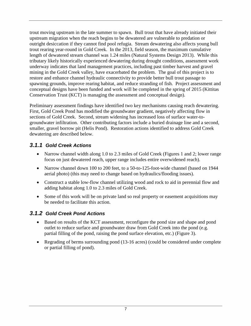
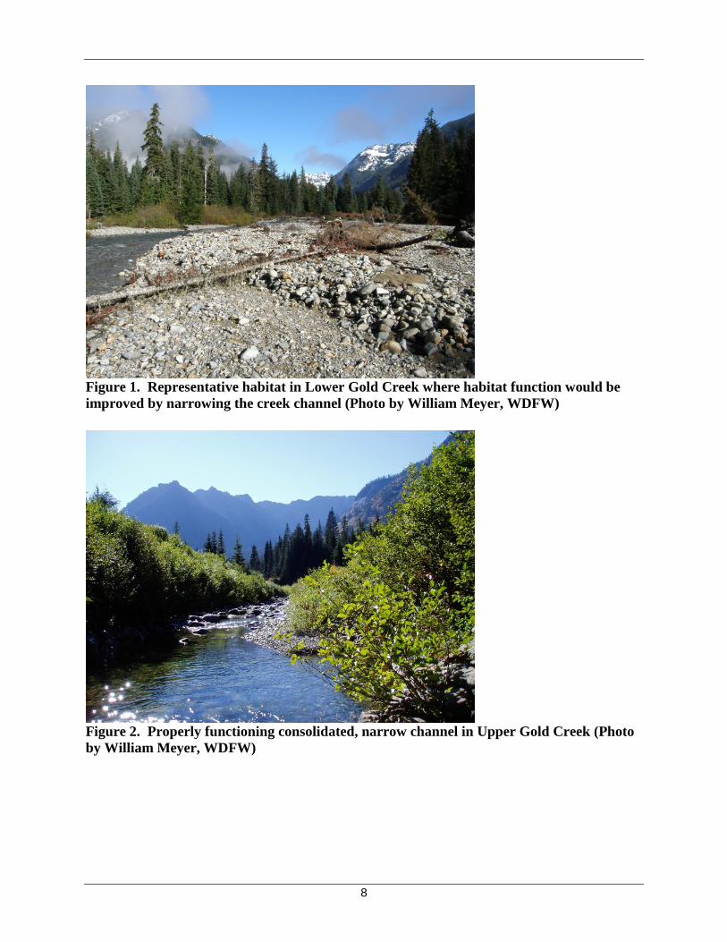
3.1.1 Gold Creek Actions • Narrow channel width along 1.0 to 2.3 miles of Gold Creek (Figures 1 and 2; lower range
focus on just dewatered reach, upper range includes entire overwidened reach).
• Narrow channel down 100 to 200 feet, to a 50-to-125-foot-wide channel (based on 1944 aerial photo) (this may need to change based on hydraulics/flooding issues).
• Construct a stable low-flow channel utilizing wood and rock to aid in perennial flow and adding habitat along 1.0 to 2.3 miles of Gold Creek.
• Some of this work will be on private land so real property or easement acquisitions may be needed to facilitate this action.
3.1.2 Gold Creek Pond Actions • Based on results of the KCT assessment, reconfigure the pond size and shape and pond
outlet to reduce surface and groundwater draw from Gold Creek into the pond (e.g. partial filling of the pond, raising the pond surface elevation, etc.) (Figure 3).
• Regrading of berms surrounding pond (13-16 acres) (could be considered under complete or partial filling of pond).
8
Figure 1. Representative habitat in Lower Gold Creek where habitat function would be improved by narrowing the creek channel (Photo by William Meyer, WDFW)
Figure 2. Properly functioning consolidated, narrow channel in Upper Gold Creek (Photo by William Meyer, WDFW)

9
Figure 3. Gold Creek Pond (Photo by William Meyer, WDFW)
3.1.3 Helis Pond Actions • Complete filling (approximately 2 acres) of Helis Pond and outlet channel.
• This work will be on private land so real property or easement acquisitions may be required to facilitate this action.
These activities would potentially require adding fill or the removal of creek bed materials. In addition, the placement of boulders, logs, or other engineered materials may be necessary to ensure that the constructed creek channel is stabilized until natural channel stabilization mechanisms are in place (e.g. native vegetation) to provide adequate cover for bull trout.
Channel restoration and filling would require in-water work and would result in increased levels of turbidity and noise that would temporarily disturb bull trout from construction areas downstream to the confluence with the reservoir. Flows may also need to be partially or completely diverted from the existing channel to allow construction access to bed materials and to prevent fish from encountering major construction activities. These impacts could be minimized if work is completed when the channel is dry.
In addition to in-water work, construction activities may require temporary access roads and heavy equipment operation in the riparian areas adjacent to the creek. The disturbance of riparian vegetation would be transient as temporary roads and other disturbed areas would be regraded and revegetated with appropriate native plant species immediately following construction. Erosion and sediment control plans would be implemented to reduce the risk of upland sediments entering the creek.

10
The timing of all in-water work would be subject to work windows that minimize the disturbance of bull trout and other aquatic and terrestrial species in the project area. The project would adhere to local, state and Federal regulatory requirements.
Real property and/or easement acquisition may be required where work would occur on privately owned lands. Acquisitions would be with willing landowners.
Design costs are expected to be approximately $250,000. The cost estimate for project implementation is $3 million.
3.2. Gold Creek USFS Bridge Replacement
The proposed project would involve construction of a new bridge on Forest Service Road 4832 (Figure 4) to restore the Gold Creek floodplain and enhance connectivity of bull trout habitat within Gold Creek and between Gold Creek and Keechelus Reservoir. The project site is located on the Okanogan-Wenatchee National Forest in Section 15, Township 22 North, Range 11 East, Willamette Meridian (Map 1).
Figure 4. Location of existing Forest Service Road 4832 bridge relative to Interstate-90 and Keechelus Reservoir. Construction of Interstate-90 (I-90) and Forest Service Road 4832 altered the hydrology and structure of Gold Creek. The original roads were constructed on fill across most of the historical floodplain, and bridges confined Gold Creek to a single active channel (Figure 5). Borrow pits and staging areas were constructed on the floodplain along both sides of the highway. A large borrow pit upstream of Forest Service Road 4832 confined Gold Creek to the western margin of its historical floodplain. This created the Gold Creek Pond that is fed by seepage and discharges

11
through an artificial outlet channel to Gold Creek. Reaches of Gold Creek upstream of the pond outlet often dewater by mid-summer. The existing Gold Creek USFS Bridge artificially constrains the floodplain and creek channel, resulting in scouring and sediment deposition patterns that prevent natural habitat processes from occurring (USDA, 2011). Interstate-90 has recently been reconstructed to span the Gold Creek floodplain, and the previous fill has been removed.
Figure 5. LiDAR Image of Gold Creek floodplain depicting areas of fill along Forest Service Road 4832 that constrict the channel migration zone and reduce floodplain functions (Figure provided by William Meyer, WDFW). All I-90 fill has now been removed. The new Gold Creek USFS Bridge would span the floodplain of Gold Creek (approximately 725 feet wide) and would provide the following benefits: improved hydrologic connectivity, lower stream velocities, improved channel migration, floodplain restoration, restored capacity for sediment transport, reduced sediment and temperature, and improved groundwater flow (USDA, 2011).
Engineered designs developed by Sargent (2011) identify several options for replacing the bridge and provide a recommendation for a preferred design alternative (Figures 6 and 7). All of the replacement options considered would require the following construction activities (a comprehensive description is provided by Sargent [2011]):
• Placement of shafts or pilings to provide a foundation for the bridge structure. Installing pilings would require an impact hammer and shafts will require drilling machines.
• Installation of the bridge superstructure using cranes and other heavy equipment,
• Installation of a detour around the construction area,

12
• Construction of temporary roads,
• Clearing and grubbing,
• Removal of the existing bridge and approach roadway fills (approximately 50,000 cubic yards of material), and
• Construction of a new embankment (approximately 6,000 cubic yards of material). In general, the bridge replacement project would require very large equipment. The construction of the shafts will require large drilling machines that occupy a very large area. This area is larger than the area provided by the existing road, so it is likely that the contractor would access the piers via the existing creek floodplain area. This would require the removal of existing vegetation and the placement of a working pad of rock (Sargent, 2011).
Construction would only occur in the months of April through October over a period of 2-3 years.
Bridge and foundation installation would require in-water work and would result in increased levels of turbidity and noise that would temporarily disturb bull trout in the construction area downstream to the confluence with the reservoir. Flows may also need to be partially or completely diverted from the existing channel to allow construction access to bed materials and to prevent fish from encountering major construction activities. Fish salvage and removal efforts would be conducted within the immediate project area to reduce the risk of injury or mortality during construction.
In addition to in-water work, construction activities would require temporary access roads, staging areas, and heavy equipment operation in the riparian areas adjacent to the creek. The disturbance of riparian vegetation would be transient as temporary roads and other disturbed areas would be regraded and revegetated with appropriate native plant species immediately following construction. Erosion and sediment control plans would be implemented to reduce the risk of upland sediments entering the creek.
The timing of all in-water work would be subject to work windows that minimize the disturbance of bull trout and other aquatic and terrestrial species in the project area. The project would adhere to local, state and Federal regulatory requirements.
The proposed project was evaluated in a NEPA Environmental Assessment (USDA, 2011a). A Decision Notice and Finding of No Significant Impact were issued by the Cle Elum Ranger District on August 10, 2011 (USDA, 2011b). The project has undergone initial design review and preliminary costing (Sargent, 2011). The estimated project cost for the new Gold Creek Bridge and associated roadway construction activities is $5.6 million.

13
Figure 6. Recommended Gold Creek USFS bridge replacement Design Sheet 15 (Drawing obtained from Sargent, 2011)

14
Figure 7. Recommended Gold Creek USFS bridge replacement Design Sheet 16 (Drawing obtained from Sargent, 2011)

15
3.3. Cold Creek Passage Improvement
This project would provide access to habitats within Cold Creek that are currently not accessible to bull trout because of passage issues at the lower reach of the creek. Cold Creek may provide a significant tributary habitat for Keechelus Reservoir bull trout (Map 2; Reiss et al. 2012) if access is provided. Cold Creek is a true headwater system that reaches to nearly 5,500 feet and whose forest is relatively intact, providing good stream complexity and cold, clean water that bull trout require (W. Meyer, Personal Communication, September 11, 2014).
Access to Cold Creek is prevented by a perched culvert and existing dewatered channel that occurs during low pool elevations (Figures 8 and 9). A previous attempt to create passage was unsuccessful as high water destroyed the constructed improvements (Reiss et al. 2012).
Figure 8. Existing Passage Barrier at Cold Creek Culvert
Figure 9. Existing Cold Creek Channel Condition Downstream of Culvert

16
The proposed project activities would include engineering, design, and installation of a bridge, removing the existing culvert, and improving channel conditions between the existing culvert and Keechelus Reservoir to provide passage to bull trout. The existing culvert crosses Cold Creek at the John Wayne Pioneer Trail and Iron Horse State Park.
The specific method of providing passage into Cold Creek has not been determined but a concept-level plan exists including the following elements (Tappel, 2012):
• Excavate the existing State Park trail (historic railroad grade) to an elevation approximately 55 feet below existing trail elevation, including removal of the existing concrete culvert.
• Build a new stream channel with 50-foot-wide bottom under the trail crossing with cross-section dimensions to more-or-less match undisturbed creek sections upstream. Use the existing creek's downstream control (plunge pool below culvert) for channel vertical control.
• Install a 120-foot-span x 14-foot-wide steel beam or prestressed concrete girder bridge for a new trail over Cold Creek about 35 feet lower than the existing trail crossing. Place the bridge superstructure on precast concrete footings protected by large armor rock (buried in stream banks).
• Gradually slope the trail at 6 percent on both sides of the new bridge, to intersect the existing John Wayne Pioneer Trail and Iron Horse State Park (old railroad grade) about 600 feet from the creek.
• Roughly excavate a 50-foot-wide channel at about 8-percent slope to 200 feet upstream of the new bridge. This channel would be excavated through existing bedload deposits (natural alluvial materials). High flows in Cold Creek would be expected to develop (headcut) an armored channel at about 5-percent slope to taper into existing creek channel reaches upstream.
• Excavated materials from the trail embankment excavation and from channel excavation would be used onsite to construct more natural bank extensions for Cold Creek downstream from the trail.
• The existing powerline along the trail has several galvanized steel cable braces and anchors would need to be replaced and reset for a lower trail grade. In addition, there may be buried fiber optic cables and other utilities adjacent to the trail that will need to be maintained or replaced.
• Reconstruction of more natural topography and ground contours downstream (south) of the trail would be followed with revegetation with native shrubs and trees to substantially improve upland resources within the project vicinity.

17
Figure 10. Conceptual Design for passage improvement at Cold Creek (Drawing obtained from Tappel, 2012)

18
These activities would potentially require adding fill or the removal of creekbed materials. In addition, the placement of boulders, logs, or other engineered materials may be necessary to ensure that the constructed creek channel is stabilized and provides adequate cover for bull trout.
Channel excavation and culvert removal would require in-water work and would likely result in increased levels of turbidity and noise that would temporarily disturb bull trout from construction area downstream to the confluence with the reservoir. Flows may also need to be partially or completely diverted from the existing channel to allow construction access to bed materials and to prevent fish from encountering major construction activities.
In addition to in-water work, construction activities may require temporary access roads and heavy equipment operation in the riparian areas adjacent to the creek. The disturbance of riparian vegetation would be transient as temporary roads and other disturbed areas would be regraded and revegetated with appropriate native plant species immediately following construction. Erosion and sediment control plans would be implemented to reduce the risk of upland sediments entering the creek.
The timing of all in-water work would be subject to work windows that minimize the disturbance of bull trout and other aquatic and terrestrial species in the project area. The project would adhere to local, state and Federal regulatory requirements.
The estimated cost of this project is expected to be $250,000 for engineering and up to $1.6 million for project implementation.
3.4. Bull Trout Task Force Project
The Bull Trout Task Force project is a combination project that includes on-the-ground work, data collection, and outreach. The Bull Trout Task Force (BTTF) is a collaborative effort between multiple organizations in the Yakima Basin to protect and restore bull trout populations through the prompt removal of recreational dams, direct outreach to anglers and recreationists, and population monitoring. The BTTF will work on threats that have been identified in the 2014 Draft Bull Trout Recovery Plan (Service 2014) and in the 2012 Yakima Bull Trout Action Plan (Reiss, et al. 2012). These threats include angling, threats associated with the building of swimming pools in creeks (i.e. recreation dams), riparian vegetation removal, harassment during spawning, streambank destruction, and poaching.
There are 15 identified local bull trout populations in the Yakima Basin that occupy a wide range of habitat, primarily foraging and overwintering in mainstem rivers and reservoirs, with spawning and rearing in headwater tributaries. These habitats are also where recreation is focused. Threats to bull trout by recreationists happen both intentionally and incidentally as a result of uneducated anglers and recreationists. A priority objective of the Bull Trout Task Force is identifying and removing recreation dams. A channel-spanning recreational dam can be constructed in an afternoon, and can block an entire year of spawning. The effects of that one dam will be experienced in the population over the long-term, particularly in the small, very vulnerable populations. The Bull Trout Task Force will educate recreationists about the unintended consequences of recreation dams and will post informational recreation dam signs in “problem” areas.
19
In addition to the removal of recreation dams, the BTTF will conduct direct outreach to anglers and recreationists regarding bull trout identification and conservation. Anglers will be given a bull trout versus brook trout identification card to keep in their tackle box. The BTTF will be deploying, maintaining and retrieving temperature data loggers in bull trout streams throughout the Yakima Basin. The BTTF temperature data collection will assist with a multiagency temperature monitoring network that will fill temperature data gaps throughout the Yakima Basin and help guide future restoration work.
The Bull Trout Task Force will work throughout the Yakima Basin and will focus much of their effort in the Keechelus and Kachess reservoirs to prevent direct take of bull trout and educate the public about species protection.
The estimated cost of this project is expected to be $33,000 a year. The proposal is to implement this project for 2 years for a total budget of $66,000.
3.5. Kachess River and Box Canyon Creek Assessment and Design
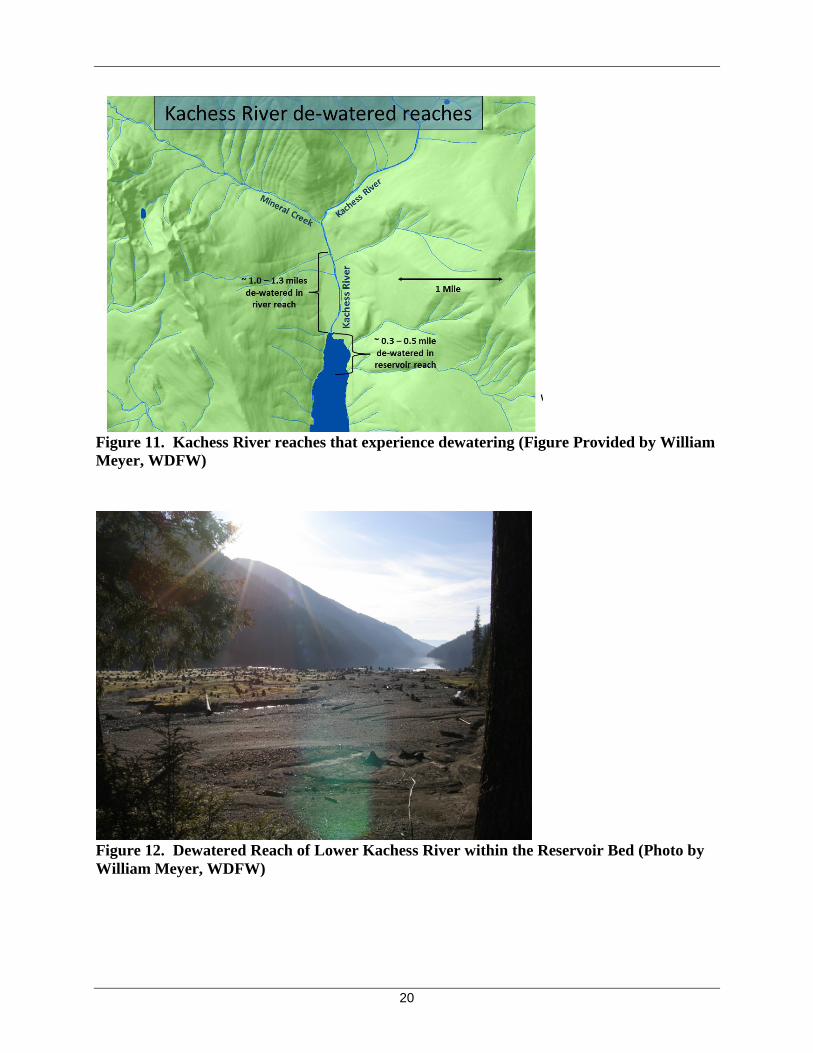
This assessment would identify opportunities to reduce or eliminate dewatering events in the Kachess River (Map 3) and Box Canyon Creek (Map 4). After assessments are complete, project designs will be developed for implementation in Phase 2 of the Bull Trout Enhancement Plan. Currently, the lower portions of these tributaries have experienced dewatering events that can prevent or delay bull trout from moving upstream into spawning grounds, and expose spawning adults or rearing juveniles to predation or desiccation.
Dewatering in the Kachess River occurs at two locations extending from the first 0.25-0.30 mile of the river above the reservoir low-pool elevation (i.e., “reservoir inundation reach”) and an additional reach 1.0 to 1.3 miles upstream of the high reservoir pool level (i.e., “upstream reach”) (Figure 11).
Within the reservoir inundation reach, there is typically adequate flow, but the unconsolidated braided channel distributes the flow over a wide area leading to shallow zones that may create a passage barrier for adults and trap for juveniles and fry. If the system loses flow due to a dry fall, these braids can go dry (Figure 12).
In the upstream reach, the valley bottom forest has been logged and the river channel is now destabilized. As a result, the channel has become too wide and sediments have been eroded and redistributed in a manner that contributes to shallow or subsurface flows and periodic dewatering (Figure 13).
20
Figure 11. Kachess River reaches that experience dewatering (Figure Provided by William Meyer, WDFW)
Figure 12. Dewatered Reach of Lower Kachess River within the Reservoir Bed (Photo by William Meyer, WDFW)
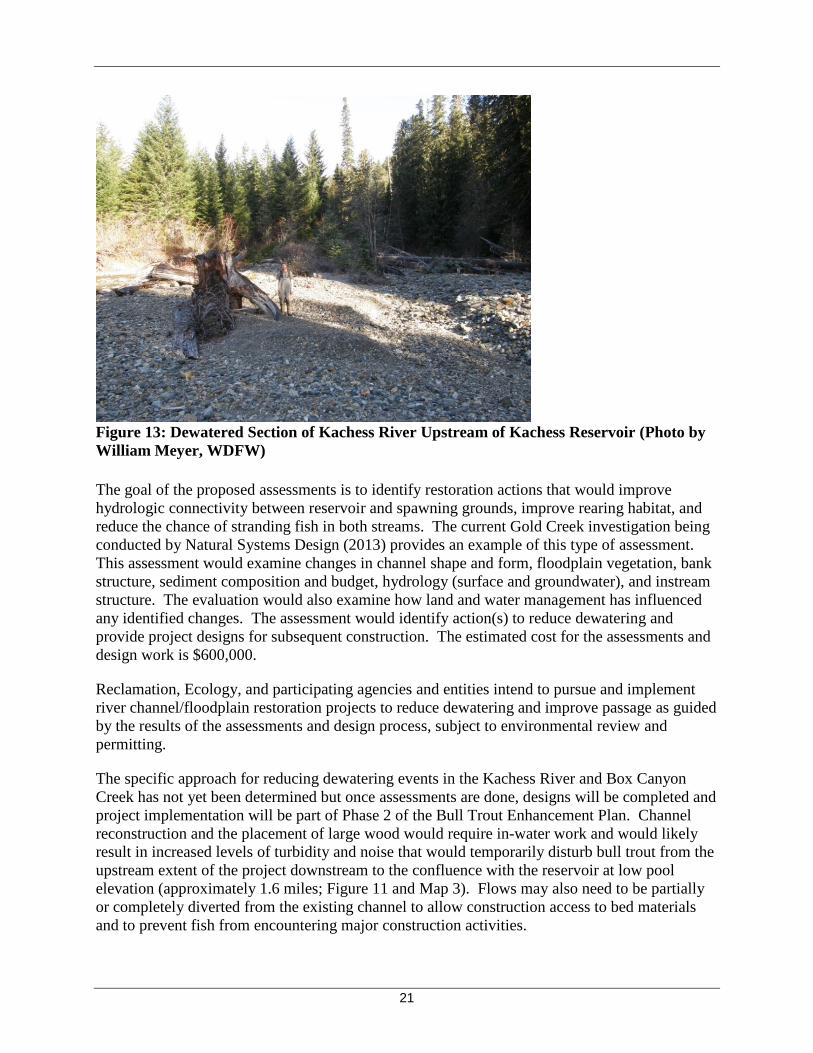
21
Figure 13: Dewatered Section of Kachess River Upstream of Kachess Reservoir (Photo by William Meyer, WDFW) The goal of the proposed assessments is to identify restoration actions that would improve hydrologic connectivity between reservoir and spawning grounds, improve rearing habitat, and reduce the chance of stranding fish in both streams. The current Gold Creek investigation being conducted by Natural Systems Design (2013) provides an example of this type of assessment. This assessment would examine changes in channel shape and form, floodplain vegetation, bank structure, sediment composition and budget, hydrology (surface and groundwater), and instream structure. The evaluation would also examine how land and water management has influenced any identified changes. The assessment would identify action(s) to reduce dewatering and provide project designs for subsequent construction. The estimated cost for the assessments and design work is $600,000.
Reclamation, Ecology, and participating agencies and entities intend to pursue and implement river channel/floodplain restoration projects to reduce dewatering and improve passage as guided by the results of the assessments and design process, subject to environmental review and permitting.
The specific approach for reducing dewatering events in the Kachess River and Box Canyon Creek has not yet been determined but once assessments are done, designs will be completed and project implementation will be part of Phase 2 of the Bull Trout Enhancement Plan. Channel reconstruction and the placement of large wood would require in-water work and would likely result in increased levels of turbidity and noise that would temporarily disturb bull trout from the upstream extent of the project downstream to the confluence with the reservoir at low pool elevation (approximately 1.6 miles; Figure 11 and Map 3). Flows may also need to be partially or completely diverted from the existing channel to allow construction access to bed materials and to prevent fish from encountering major construction activities.

22
In addition to in-water work, construction activities may require temporary access roads and heavy equipment operation in the riparian areas adjacent to the creek. The disturbance of riparian vegetation would be transient, as temporary roads and other disturbed areas would be regraded and revegetated with appropriate native plant species immediately following construction. Erosion and sediment control plans would be implemented to reduce the risk of upland sediments entering the creek.
The timing of all in-water work would be subject to work windows that minimize the disturbance of bull trout and other aquatic and terrestrial species in the project area. The project would adhere to local, state, and Federal regulatory requirements
3.6. Box Canyon Passage Assessment
This assessment would determine if passage at a natural barrier is biologically sound and if it would address any limiting factors for bull trout within Kachess Reservoir. Bull trout access to the upper reaches of Box Canyon Creek is restricted by a natural, impassable waterfall (Peek-a-Boo Falls) approximately 1.6 miles upstream of the confluence with Kachess Reservoir (Map 4; Reiss et al. 2012).
This assessment would evaluate habitat condition and capacity (fish production) downstream from the falls, examine the benefits of providing passage for bull trout and anadromous fish (when future passage is provided at Kachess Dam) above the falls, and to evaluate risks to fish species and ecological relationships currently found above the falls. The benefits of this project would also be considered within the context of the population enhancement evaluation (see Section 3.8) which would help determine the extent to which access to new tributary habitat would address population limiting factors. The estimated cost of the assessment is $200,000. If the assessment results in support for expanding habitat access upstream of the falls, fish passage design and project construction would be completed in Phase 2 of the Bull Trout Enhancement Plan. Reclamation, Ecology, and participating agencies and entities intend to pursue and implement a passage project at Peek-a-Boo Falls within Box Canyon Creek that is guided by the results of the assessment.
3.7. South Fork Tieton River Passage Assessment and Design
Improving passage into the South Fork Tieton is important for the bull trout populations affected by the KKC and KDRPP projects. This action would provide flow management options that could reduce drawdown impacts in the upper Yakima reservoirs by using Rimrock storage in a manner that could delay the need for pumping from Kachess and allowing more time for bull trout to pass into Kachess tributaries. In addition, this proposal also could provide increased flexibility and options to reduce high flows during “flip-flop” operations that adversely affect habitat for bull trout, steelhead, salmon, and lamprey in the Tieton and lower Naches. Finally, enhancing the South Fork Tieton population is important to help maintain a potential future donor population and to provide an opportunity for colonization and metapopulation function when passage is provided throughout the upper Yakima Basin through the Integrated Plan (Reclamation and Ecology, 2011).

23
This assessment would examine existing passage issues, habitat conditions, and reservoir operations with the goal of improving passage into the South Fork Tieton River (Map 5), reducing potential passage issues in Kachess Reservoir during operation of the KDRPP pumps, and reducing the risk of injury to downstream migrants. Upon the completion of the assessment, a fish passage option will be chosen and project engineering and design will be completed as part of this phase. When Forest Service Road 1200 was constructed, the natural channel of the South Fork Tieton River was relocated to flow under the bridge through a notch blasted out of bedrock (Figure 14). A waterfall begins to form at this location when the reservoir is drafted below 131,000 acre-feet. It is believed to become impassable for bull trout attempting to migrate upstream when the pool volume drops below 127,000 acre-feet (Thomas, 2001, cited in Reiss et al. 2012). The falls create a downstream passage and injury issue when post-spawning bull trout drop over the waterfall and land in a shallow pool and then have to descend a shallow braided channel to get back to the reservoir.
The habitat assessment would evaluate different opportunities to provide passage through consideration of approaches such as a roughened channel, grade control, or rerouting the channel back to natural thalweg. The estimated cost of the habitat assessment is $200,000. An additional analysis of reservoir operations would also be conducted to determine the value of adjusting reservoir elevations to improve passage and promote habitat functions downstream. The estimated cost of the operational assessment would be $100,000.
Figure 14. Rimrock Reservoir drawdown resulting in passage barrier at the South Fork Tieton River below Forest Service Road 1200 (Photo by William Meyer, WDFW) Reclamation, Ecology, and participating agencies and entities intend to pursue passage improvement project(s) at South Fork Tieton River that are identified as beneficial in the assessments, subject to environmental review and permitting. The estimated cost of the passage assessment is $300,000. Following the assessment, a passage option will be chosen and project engineering and design will be completed. The estimated cost of engineering and design is

24
estimated to be $250,000. Implementing the passage project will be part of Phase 2 of the Bull Trout Enhancement Plan.
3.8. Bull Trout Population Enhancement Evaluation
This assessment would evaluate the efficacy of directly increasing the abundance and diversity of bull trout in the reservoirs using translocation and or supplementation methods. Translocation moves bull trout from a healthy population to place them into a population in need of enhancement and/or into habitat that bull trout have been extirpated. An example of this would be to move bull trout from healthy external population to habitats within Keechelus and Kachess reservoirs or the Teanaway watershed (likely an extirpated population). The method of obtaining fish from the donor populations has not been determined.
DeHaan and Bernall (2013) demonstrated that transporting fish to habitats above passage barriers is an effective conservation strategy that can reduce the effects of population fragmentation. In their study, bull trout transported upstream from below Cabinet Gorge Dam, Clark Fork River, Idaho, successfully spawned and produced a significant number of juveniles that were later attributable to transported parents. Translocation has been used effectively in other basins to reintroduce bull trout to habitats they formerly occupied. In the Clackamas River Basin, translocation occurred after completion of a feasibility study and the results have been promising. Introduced bull trout have dispersed throughout the Clackamas River and its tributaries and spawning behavior has been documented (Barry et al. 2014). Genetic risks will need to be evaluated. Translocation of even a few fish from another population may have significant impacts to the genetics of a small population.
The keys to successful translocation efforts are an understanding of the potential for recipient habitats to support a reintroduction and the potential of available donor populations to support a reintroduction (Dunham et al. 2011). In recognition of these requirements, a feasibility assessment will be conducted similar to Dunham et al. (2011), which will consider population status, habitat quality and quantity, habitat limiting factors in reservoirs and tributary habitats, entrainment risk, fish health, threats, metapopulation dynamics, genetic analysis, extinction risk, and donor-recipient sensitivity analysis.
Another approach to population enhancement that will be evaluated is supplementation. Supplementation differs from translocation in that bull trout would be bred in a more controlled environment (e.g. a hatchery) to increase juvenile survival rates and their offspring would be planted in the reservoirs or tributary habitats. Supplementation is an effective tool for increasing the number of fish available for reintroduction but poses potentially significant genetic risks (Leary et al. 1993) such as inbreeding effects that can accelerate population declines (Rieman and Allendorf, 2001).
The feasibility assessment will result in a quantitative decisionmaking framework that will ensure the priority and efficacy of subsequent population enhancement efforts. The assessment will play an important role in determining whether or not population enhancement is congruent with available habitat capacity and genetic risks. To ensure coordination and consultation requirements are met in a timely fashion, the project will utilize existing proposal information that has been developed by key stakeholders and managers including WDFW, Yakama Nation,

25
the Service, USGS, USFS, and Yakima Basin Fish and Wildlife Recovery Board (e.g., Conley, et al. 2014). Because the results from this project will inform where habitat capacity may be limited, the evaluation will also have utility guiding other decisions related to habitat restoration projects. The estimated cost for the population enhancement evaluation is $500,000. If the population enhancement evaluation recommends implementation, translocation and/or supplementation actions will be part of the Phase 2 Bull Trout Enhancement Plan.
3.9. Improve Productivity and Food Resources
Both Keechelus and Kachess reservoirs are oligotrophic environments (unproductive systems) that may have limited food resources to support bull trout at different life history stages. Providing nutrient enhancement in tributaries and the reservoirs (i.e., salmon carcasses, carcass/analogs, or chemical inputs) is one method of replacing nutrients formerly provided by anadromous salmon (Pearsons et al. 2007). Nutrient enhancement increases productivity through a bottom-up approach where nutrients are first utilized by primary producers (i.e., algae and plants) which are then consumed by insects and zooplankton that feed fish and other aquatic life in a cascade of food chain interactions. Over the long term, the Integrated Plan (Reclamation and Ecology, 2011) proposes to establish passage for anadromous species which would functionally recreate the historic productivity (marine-based nutrient inputs) and prey base that bull trout experienced prior to the installation of dams at both Keechelus and Kachess reservoirs. As an interim measure, this plan proposes nutrient enhancement using treated salmon carcasses and/or carcass/analogs to increase ecological productivity, thereby increasing the prey base for bull trout, recognizing that the long-term solution is represented by anadromous passage above the reservoir dams. The goal of this project is to add nutrients (i.e., salmon carcasses and/or carcass/analogs), to these oligotrophic systems. Added nutrients will increase ecological productivity, translating into an increase in food supply for bull trout. Adaptive management will be used to determine appropriate levels on nutrient inputs as this project is implemented over time.
Introducing pathogens with the placement of carcasses is a primary concern. To address this, all carcasses will be treated by heat to kill any pathogens that may be present prior to hauling and placement. Carcasses will be placed in tributaries that are historic spawning streams including Gold Creek, Box Canyon Creek and Kachess River. Carcasses will be placed when spawning would have historically occurred during the fall months starting in late September and ending in November. Impacts to water quality are expected to be insignificant because carcass decomposition and nutrient release will occur overtime and nutrient uptake is expected to be relatively quick due to the lack of nutrients in the existing system.
The cost estimate for this project is $200,000 for the study component and $50,000 per year for 10 years of nutrient enhancement activities ($500,000 over 10 years).
If the ongoing food web studies of limiting factors in Keechelus and Kachess reservoirs indicate that the abundance of prey is a limiting factor for bull trout survival or productivity in the reservoirs, an evaluation of the feasibility of providing additional kokanee prey may be warranted.

26
CHAPTER 4: SUMMARY OF ANTICIPATED ENHANCEMENT PROJECT BENEFITS AND THREATS ADDRESSED All the proposed enhancement actions address significant population threats identified in the YBTAP (2012) and are consistent with recommended actions therein (Tables 1-4). The potential benefits of each project and action, relative to the primary threats they address, are summarized in Table 5 and described below.
Table 5. Summary of Enhancement Projects and Primary Threats Addressed for Bull Trout Populations
Enhancement Project
Threats Addressed Low
Abundance Passage Barriers Dewatering Limited
Habitat Prey Base
Gold Creek Passage and Habitat Improvement
X XXX XXX XXX X
Gold Creek USFS Bridge Replacement
X X X X
Cold Creek Passage Improvement
X XXX XXX X
Bull Trout Task Force X XXX Kachess River and Box Canyon Creek Assessment and Design
X XXX XXX XXX X
Box Canyon Passage Assessment (Peek-a-boo falls) 1
X XXX X
South Fork Tieton River Passage Assessment and Design
X XXX X XXX
Bull Trout Population Enhancement Evaluation
XXX
Improve Productivity and Food Resources
X XXX
1 Assumes results of assessment support future project implementation XXX Denotes substantial benefit X Denotes minor benefit
The Gold Creek Passage and Habitat Improvements Project will directly address threats posed by dewatering and seasonal passage barriers within the Gold Creek tributary. This project, in conjunction with bull trout population enhancement efforts, should increase the abundance and diversity of bull trout by improving access to spawning habitats, reducing loss caused by predation and desiccation, and improving stream rearing conditions for both existing and introduced bull trout.
27
The Gold Creek USFS Bridge Replacement project will restore floodplain and channel forming processes to a more natural state. This project would support the goal of increasing abundance through improving connectivity with important spawning and rearing habitats.
The Cold Creek Passage Improvement and Box Canyon Passage Assessment will provide passage (Cold Creek) and assessments and design solutions (for Box Canyon if determined to be biologically sound) to open habitats that are not currently utilized by bull trout. The effectiveness of the design solutions will be dependent upon the results of the assessment and whether or not supplemental habitat improvements are implemented in the future. These actions, in conjunction with the bull trout population enhancement efforts, should increase the abundance and diversity of bull trout by improving access to new spawning and rearing habitats and increasing the diversity of available habitats.
The Kachess River and Box Canyon Creek Assessment and Design has the potential to directly address threats posed by dewatering and seasonal passage barriers within the Kachess River and Box Canyon Creek. The effectiveness of this action will be dependent upon the results of the assessment/design and whether or not habitat improvements are implemented in Phase 2. Successfully addressing stream dewatering would improve access to spawning and rearing habitat and reduce losses caused by predation and desiccation.
Conducting the Bull Trout Population Enhancement Evaluation will provide baseline data to inform decisions related to bull trout translocation and/or supplementation. The evaluation will ensure that enhancement activities are well aligned with available habitat capacity, consider population genetic risks, and provide a decisionmaking framework for implementation. Successfully enhancing bull trout populations will be dependent on determining the best method of population enhancement consistent with available habitat (includes restored habitat) and evaluating if population enhancement is biologically sound. Future implementation would be included in the Bull Trout Enhancement Plan Phase 2.
Improving reservoir and tributary productivity and availability of food resources utilizing nutrient enhancement will improve bull trout prey base.
Overall, the proposed habitat improvements, bull trout population enhancement efforts, and prey base enhancements have the highest potential benefit when combined. The expected incremental improvements in habitat function, increase in abundance of bull trout, and additional food resources will interact synergistically to reduce several of the more significant threats to populations in the Keechelus and Kachess watersheds and larger Yakima Basin—low abundance, passage barriers, dewatering, limited habitat and prey base.
CHAPTER 5: COST FOR PHASE 1 OF THE BULL TROUT ENHANCEMENT PLAN The information provided in this section is a summary of estimated costs for each project and action. Each of the proposed projects will require funding and authorization prior to implementation. Individual estimated project costs are summarized in Table 6. If all of the projects and actions were implemented, the estimated total cost would be $13,316,000. Future

28
actions based on assessments and design work completed in Phase 1 will require additional funding not included in the list below and will be implemented as part of Phase 2 of the Bull Trout Enhancement Plan.
Table 6. Summary of Estimated Project Costs for Phase 1 of the BTE
Project Assessment and Design
Costs Construction and Implementation Total
Gold Creek Passage & Habitat Improvements* $250,000 $3,000,000 $3,250,000
Gold Creek USFS Bridge Replacement N/A $5,600,000 $5,600,000
Cold Creek Passage Improvement* $250,000 $1,600,000 $1,850,000
Bull Trout Task Force N/A $66,000 $66,000
Kachess River & Box Canyon Passage & Habitat Assessment and Design* $600,000 TBD $600,000
Box Canyon Passage Assessment and Design $200,000 TBD $200,000
South Fork Tieton River Passage Assessment & Design* $550,000 TBD $550,000
Bull Trout Population Enhancement Evaluation* $500,000 TBD $500,000 Improve Productivity and Food Resources (nutrient enhancement)* $200,000 $500,000 $700,000
Grand Total $13,316,000 *Priority actions based on expected benefit and information needs to address bull trout restoration needs. TBD: To be determined.
CHAPTER 6: BULL TROUT ENHANCEMENT – PHASE 2 Bull Trout Enhancement Plan - Phase 2 would include implementation of the results of each assessment listed in Phase 1. As the Kachess Drought Relief Pumping Plant and Keechelus-To-Kachess Conveyance projects are implemented, Reclamation and Ecology, with the assistance of the Yakama Nation and fish agencies, will prioritize the work to be accomplished. Anticipated projects and actions include:
• Construct passage and habitat restoration for o Kachess River passage and habitat improvements o Box Canyon passage and habitat improvements.
• Construct Box Canyon Passage at Peek-a-boo falls (if determined sound and beneficial).
• Construct South Fork Tieton River Passage Restoration Action.
• Implement Bull Trout Population Enhancement Actions (translocation and/or supplementation).

29
CHAPTER 7: MEMORANDUM OF UNDERSTANDING A Memorandum of Understanding (MOU) has been entered into by the Yakama Nation, the Service, WDFW, USFS, and Ecology, with Reclamation’s Columbia-Cascades Area (collectively, “the parties”) to define their respective roles in the development and the implementation of the Integrated Plan, specifically, to implement bull trout recovery actions and/or projects within the Yakima Basin to achieve self-sustainable, healthy, harvestable populations of native bull trout, which are currently listed with the Service as a threatened species pursuant to the Endangered Species Act of 1973, as amended (Act) (64 FR 58910; November 1, 1998).
The purpose of the MOU is to provide a framework in which to coordinate and facilitate cooperation among the parties to develop and implement bull trout recovery actions within the Yakima River basin. Bull trout recovery actions are intended to support the fish passage, habitat restoration, and habitat/watershed protection elements contained in the Integrated Plan Final PEIS, as well as subsequent project-level EISs. Objectives of this MOU include using Integrated Plan processes and committees to ensure proposed bull trout recovery actions are most effective at achieving bull trout recovery in the Yakima Basin. The YBTAP (Reiss, et al. 2012) and the Service’s Bull Trout Recovery Plan (Whitesel, et al. 2004) are examples of bull trout resource protection and enhancement plans that will be used to inform the Integrated Plan bull trout decisions.
CHAPTER 8: MITIGATION As noted in the introduction, the enhancement projects proposed in this document are separate from the mitigation actions that may be required for the proposed KDRPP and KKC projects. The mitigation actions are described here as a reference and to clearly delineate the differences between mitigation and enhancement projects. Additional mitigation may be identified through environmental compliance processes; such as, but not limited to ESA, Clean Water Act, etc.
8.1. Mitigation Measures
To address KDRPP and KKC project-specific bull trout impacts, Reclamation proposes to conduct the following activities:
• Adaptively manage Reclamation’s emergency monitoring/passage program so that it is responsive to increased passage risk into spawning tributaries. o Monitor for new or increased occurrence of barriers to spawning tributaries caused by
reservoir drawdown operations. o Provide emergency passage for bull trout if permanent facilities are not in place to
address passage barriers affected by operations.
• Construct permanent fish passage structures or habitat modifications to minimize or fully address potential passage barriers o Between Kachess Reservoir and Lower Box Canyon Creek,

30
o Between Kachess Reservoir and Little Kachess basins, o Between Keechelus Reservoir and Gold Creek (the Gold Creek project is unlikely to
fix operations-based fish barriers), and o Any other identified locations
• Examine reservoir productivity and food web impacts from future use of Kachess Reservoir inactive storage.
• Address increased entrainment risk associated with new facilities. o Install screening on all new diversions and pumps.
In conducting mitigation and enhancement activities, Reclamation will adhere to state, Federal, and local regulations as well as consult with the Service and NMFS on ESA requirements.

31
CHAPTER 9: MAPS

32
Map 1. Gold Creek Project Area depicting Gold Creek, Keechelus Reservoir, and adjacent land ownership

33
Map 2. Cold Creek Project Area depicting Cold Creek, Keechelus Reservoir, and adjacent land ownership

34
Map 3. Kachess River Project Area depicting Kachess River, Mineral Creek, Kachess Reservoir, and adjacent land ownership

35
Map 4. Box Canyon Creek Project Area depicting Box Canyon Creek, Kachess Reservoir, and adjacent land ownership

36
Map 5. South Fork Tieton Project Area depicting South Fork Tieton River, Rimrock Reservoir, and adjacent land ownership

37
References Barry, P., Hudson, J.M., Williamson, J.D., Koski, M.L., Clements, S.P. 2014. Clackamas River Bull Trout Reintroduction Project, 2013 Annual Report. Oregon Department of Fish and Wildlife and U.S. Fish and Wildlife Service, 46 pp. Beauchamp, D.A., Van Tassell, J.J. 2001. “Modeling Seasonal Trophic Interactions of Adfluvial Bull Trout in Lake Billy Chinook, Oregon.” Transactions of the American Fisheries Society 130, 204–216. doi:10.1577/1548-8659(2001)130<0204:MSTIOA>2.0.CO;2 Conley et al. 2014. Proposal: Feasibility Assessment to Restore Yakima Basin Bull Trout Populations. DeHaan, P.W., Bernall, S.R. 2013. “Spawning Success of Bull Trout Transported above Main-Stem Clark Fork River Dams in Idaho and Montana.” North American Journal of Fisheries Management 33, 1269–1282. doi:10.1080/02755947.2013.839971 Dunham , J., K. Gallo, D. Shively, C. Allen, B. Goehring. 2011. “Assessing the Native Fish Reintroductions: A Framework Applied to Threatened Bull Trout.” North American Journal of Fisheries Management 31: 106-155. Fraley, J.J. and B.B. Shepard (1989). “Life History, Ecology and Population Status of Migratory Bull Trout (Salvelinus confluentus) in the Flathead Lake and River System, Montana” Northwest Science NOSCAX 63(4): 133-142. Hoelscher, B. and T.C. Bjornn. 1989. Habitat, density and potential production of trout and char in Pend Oreille Lake tributaries. Project F-71`-R-10, Subproject III, Job No. 8. Idaho Department of Fish and Game. Boise, Idaho. Leary, R.F., Allendorf, F.W., Forbes, S.H. 1993. “Conservation Genetics of Bull Trout in the Columbia and Klamath River Drainages.” Conservation Biology 7, 856–865. doi:10.1046/ j.1523-1739.1993.740856.x Mastin, M.C. 2008. Effects of potential future warming on runoff in the Yakima River Basin, Washington: U.S. Geological Survey Scientific Investigations Report 2008-5124, 12 p. Natural Systems Design. 2013. Draft Gold Creek Hydrologic Assessment Memo provided to Kittitas Conservation Trust. December 5, 2013. Pearsons, T.N., Roley, D.D., Johnson, C.L. 2007. “Development of a Carcass Analog for Nutrient Restoration in Streams.” Fisheries 32, 114–124. doi:10.1577/1548-8446(2007)32 [114:DOACAF]2.0.CO;2

38
Pratt, K.L. 1992. “A review of bull trout life history.” Pages 5 - 9 in Howell, P.J. and D.V. Buchanan, eds. Proceedings of the Gearhart Mountain bull trout workshop. Oregon Chapter of the American Fisheries Society, Corvallis, Oregon. Reclamation and Ecology. 2011. Yakima River Basin Study, Proposed Integrated Water Resource Management Plan – Volume 1. Contract No. 08CA10677A ID/IQ, Task 11. Prepared by HDR Engineering, Anchor QEA, ECONorthwest, ESA Adolfson, and Golder Associates. April 2011. Reiss, Y., J. Thomas, E. Anderson, J. Cummins. 2012. Yakima Bull Trout Action Plan. Yakima Basin Fish and Wildlife Recovery Board, Yakima, Washington. Rieman, B.E. and J.D. McIntyre (1993). Demographic and habitat requirements for conservation of bull trout. Ogden, Utah (324 25th St. Ogden 84401). U.S. Dept. of Agriculture, Forest Service, Intermountain Research Station. Rieman, B.E. and J.D. McIntyre (1995). "Occurrence of Bull Trout in Naturally Fragmented Habitat Patches of Varied Size." Transactions of the American Fisheries Society. 124(3):285. Rieman, B.E., Allendorf, F.W. 2001. “Effective Population Size and Genetic Conservation Criteria for Bull Trout.” North American Journal of Fisheries Management 21, 756–764. doi:10.1577/1548-8675(2001)021<0756:EPSAGC>2.0.CO;2 Rieman, B. E. and D. L. Myers (1997). "Use of Redd Counts to Detect Trends in Bull Trout (Salvelinus confluentus) Populations." Conservation Biology 11(4): 1015-1018. Sargent, 2011. Gold Creek Bridge and Gold Creek Wildlife Crossing Design Report. Prepared by Sargent Engineers Inc. Submitted to USDA, Forest Service, Pacific Northwest Region. Sedell, J.R. and F.H. Everest. 1991. Historic changes in poll habitat for Columbia River Basin salmon under study for TES listing. Draft USDA Report. Pacific Northwest Research Station. Corvallis, Oregon. Service. 2014. Revised draft recovery plan for the coterminous United States population of bull trout (Salvelinus confluentus). U.S. Fish and Wildlife Service. Portland, Oregon. xiii + 151 pp Small. M. P., D. Hawkins and J. Von Bargen. 2009. Genetic Analysis of Yakima Basin Bull Trout (Salvelinus confluentus) Final Revised Report, June 17, 2009. Federal Contract E-1-81. Washington Department of Fish and Wildlife. Genetics Lab. Olympia, Washington. Tappel, P. 2012. Cold Creek Fish Passage Project Memorandum. Submitted February 1, 2012, to David Gerth, Kittitas Conservation Trust.

39
U.S. Department of Agriculture Forest Service (a). June 2011. Gold Creek Bridges and F.S. Road #4832 Reconstruction Environmental Assessment. Cle Elum Ranger District, Okanogan-Wenatchee National Forest. Kittitas County, Washington. U.S. Department of Agriculture Forest Service (b). August 2011. Gold Creek Bridges and F.S. Road #4832 Reconstruction Decision Notice/Finding of No Significant Impact. Cle Elum Ranger District, Okanogan-Wenatchee National Forest. Kittitas County, Washington. Watson, G. and T.W. Hillman. 1997. “Factors affecting the distribution and abundance of bull trout: and investigation at hierarchical scales.” North Amer. J. Fisheries Management 17:237-252. Whitesel, T.A. and 7 coauthors. 2004. “Bull Trout Recovery Planning: A review of the science associated with population structure and size.” Science Team Report # 2004-01. U.S. Fish and Wildlife Service, Regional Office, Portland, Oregon.