Embed Size (px)
Citation preview
April 2017 www.camsys.com
Treasure Coast Regional Long Range Transportation Plan - Freight Element
prepared for
Florida Department of Transportation District 4
prepared by
Cambridge Systematics, Inc.
in association with
Kimley-Horn and Associates, Inc.
draft
report
April 2017
CAMBRIDGE SYSTEMATICS
www.camsys.com

report
Treasure Coast Regional Long Range Transportation Plan - Freight Element
prepared for
Florida Department of Transportation District 4
prepared by
Cambridge Systematics, Inc. 2101 West Commercial Boulevard, Suite 3200 Fort Lauderdale, FL 33309
date
April 2017


Treasure Coast Regional Long Range Transportation Plan - Freight Element
Cambridge Systematics, Inc. i
Table of Contents
1.0 Introduction and Background ........................................................................................................... 1-1
2.0 Existing Freight Policies, Objectives, and Visions ......................................................................... 2-1
2.1 Existing Federal and State Freight Guidance ............................................................................ 2-1
2.2 Indian River County Freight Goals and Objectives .................................................................... 2-2
2.3 Martin County Freight Goals and Objectives ............................................................................. 2-3
2.4 St. Lucie County Freight Goals and Objectives ......................................................................... 2-4
3.0 Freight and Logistics System Elements .......................................................................................... 3-1
3.1 Key Freight Roadways ............................................................................................................... 3-1
3.1.1 Key Roadway Designations .......................................................................................... 3-1
Strategic Intermodal System Roadways ....................................................................... 3-1
National Highway Freight Network ............................................................................... 3-4
Regionally Significant Roadways .................................................................................. 3-7
3.1.2 Key Truck Corridors ...................................................................................................... 3-7
3.2 Key Freight Railroads .............................................................................................................. 3-11
3.2.1 Florida East Coast Railway ......................................................................................... 3-13
3.2.2 CSX ............................................................................................................................. 3-13
3.2.3 South Central Florida Express .................................................................................... 3-13
3.3 Seaports and Waterways ......................................................................................................... 3-14
3.3.1 Port of Fort Pierce ....................................................................................................... 3-14
3.3.2 Regional Waterways of the Treasure Coast ............................................................... 3-15
3.4 Airports ..................................................................................................................................... 3-17
3.4.1 Vero Beach Regional Airport ...................................................................................... 3-18
3.4.2 Treasure Coast International Airport and Business Park ........................................... 3-18
3.4.3 Witham Field ............................................................................................................... 3-19
3.4.4 Economic Impact of the Treasure Coast Airports ....................................................... 3-20
3.5 Other Key Industrial Areas ....................................................................................................... 3-21
3.5.1 Freight Activity Centers and Land Use ....................................................................... 3-21
3.5.2 Foreign Trade Zones .................................................................................................. 3-27
3.5.3 Truck Parking Facilities ............................................................................................... 3-27
3.5.4 Pipeline Developments ............................................................................................... 3-31
4.0 Freight Needs and Priorities ............................................................................................................. 4-1
4.1 Freight Roadway Needs and Priorities ...................................................................................... 4-1
4.1.1 Regional Freight Roadway Network ............................................................................. 4-1
Primary Regional Facilities ........................................................................................... 4-1

Treasure Coast Regional Long Range Transportation Plan - Freight Element
Cambridge Systematics, Inc. ii
Secondary Regional Facilities ...................................................................................... 4-2
4.1.2 Roadway Needs ............................................................................................................ 4-2
4.1.3 Freight Prioritization ...................................................................................................... 4-2
4.1.4 Integration with the Treasure Coast Regional LRTP .................................................... 4-4
4.2 Non-Roadway Needs ................................................................................................................. 4-4
4.2.1 Railroad Needs ............................................................................................................. 4-4
4.2.2 Seaport and Waterway Needs ...................................................................................... 4-4
4.2.3 Airport Needs ................................................................................................................ 4-5
5.0 Summary of Freight System ............................................................................................................. 5-1
Appendix A. Existing Freight Plans and Programs ....................................................................... A-1
Appendix B. Prioritization Process ................................................................................................. B-1
Appendix C. Scoring Worksheet ..................................................................................................... C-1

Treasure Coast Regional Long Range Transportation Plan - Freight Element
Cambridge Systematics, Inc. iii
List of Tables
Table 2.1 Indian River County Freight Goals and Objectives .............................................................. 2-3
Table 2.2 Martin County Freight Goals and Objectives ........................................................................ 2-4
Table 2.3 St. Lucie County Freight Goals and Objectives .................................................................... 2-4
Table 3.1 Top 10 Highest Volume Regional Roadways by Truck Traffic ............................................. 3-9
Table 3.2 Top 10 Highest Volume Regional Roadways by Truck Share of Traffic ............................ 3-11
Table 3.3 Atlantic Intracoastal Waterway Cargo Volumes, 2007 through 2014 Jacksonville, FL to Miami, FL ............................................................................................................................ 3-17
Table 3.4 Economic Impact of the Treasure Coast Airports ............................................................... 3-20
Table 3.5 Freight Facilities by Land Area ........................................................................................... 3-21
Table 3.6 Freight Facilities by Building Size ....................................................................................... 3-22
Table 3.7 Truck Parking Locations in the Treasure Coast Region ..................................................... 3-29
Table 4.1 Top 10 Roadway Projects .................................................................................................... 4-3
Table 4.2 Funded Seaport Projects ...................................................................................................... 4-4
Table 4.3 Unfunded Seaport Projects .................................................................................................. 4-5
Table 4.4 Airport Improvements Identified in FDOT Work Program ..................................................... 4-6
Table A.1 Existing Freight Plans and Programs ................................................................................... A-1


Treasure Coast Regional Long Range Transportation Plan - Freight Element
Cambridge Systematics, Inc. v
List of Figures
Figure 3.1 Treasure Coast Freight Network .......................................................................................... 3-2
Figure 3.2 SIS Roadways in the Treasure Coast Region ...................................................................... 3-3
Figure 3.3 Primary Highway Freight System ......................................................................................... 3-5
Figure 3.4 Truck Volumes on Treasure Coast Regional Roadways ...................................................... 3-8
Figure 3.5 Truck Share of Traffic on Treasure Coast Regional Roadways ......................................... 3-10
Figure 3.6 Freight Railroads in the Treasure Coast Region ................................................................ 3-12
Figure 3.7 Development Options for Fisherman’s Wharf .................................................................... 3-15
Figure 3.8 Martin/St. Lucie Regional Waterways Plan Study Area ..................................................... 3-16
Figure 3.9 Example of Yacht Industry .................................................................................................. 3-17
Figure 3.10 Planned Airport Facilities and Infrastructure Improvements at Vero Beach Regional Airport ................................................................................................................................. 3-18
Figure 3.11 Recommended Developments for the Treasure Coast International ................................. 3-19
Figure 3.12 Freight Activity Center Example – I-95 and 20th Street (Indian River) ............................... 3-23
Figure 3.13 Freight Activity Center Example – Vero Beach Regional Airport (Indian River) ................. 3-24
Figure 3.14 Freight Activity Center Example – Treasure Coast International Airport (St. Lucie) .......... 3-24
Figure 3.15 Freight Activity Center Example – I-95 and Florida’s Turnpike (St. Lucie) ......................... 3-25
Figure 3.16 Freight Activity Center Example – I-95 and St. Lucie W Blvd (St. Lucie) ........................... 3-25
Figure 3.17 Freight Activity Center Example – I-95 and SW Martin Highway (Martin) .......................... 3-26
Figure 3.18 Freight Activity Center Example – SR 710 in Indiantown (Martin) ..................................... 3-26
Figure 3.19 Truck Parking Locations in the Treasure Coast Region ..................................................... 3-28
Figure 3.20 Private Truck Parking Facility Example .............................................................................. 3-30
Figure 3.21 Public Truck Parking Facility Example ............................................................................... 3-30
Figure 3.22 New Interstate Pipeline ....................................................................................................... 3-31


Treasure Coast Regional Long Range Transportation Plan - Freight Element
Cambridge Systematics, Inc. 1-1
1.0 Introduction and Background
The Treasure Coast region has been actively engaged in regional transportation planning for several years. Freight was identified as a key component for the 2040 Treasure Coast Regional Long Range Transportation Plan (RLRTP). This report summarizes the region’s freight transportation system and serves as input to the RLRTP. Freight transportation is a critical element of the long range planning under taken by M/TPOs.
Federal guidance relating to freight transportation to states and MPOs continues to strengthen. The importance of freight at the national level began in 1991 with ISTEA; each subsequent bill has strengthened this message. The national freight policy is designed to drive U.S. global competitiveness. Fixing America’s Surface Transportation Act (FAST Act), passed December 4, 2015, further increased the focus and funding available for freight.
The national freight program provides new funding opportunities. The FAST Act established the Nationally Significant Freight and Highway Projects (NSFHP) Program. This program provides dedicated funding for eligible NSFHP projects. In addition to the dedicated formula funds provided to each state, a discretionary competitive grant program was created called the FASTLANE Grant Program (also know as Fostering Advancements in Shipping and Transportation for the Long-term Achievement of National Efficiencies).
These new funding programs are designed to help address ongoing challenges, including: Safe, efficient, and reliable movement of freight and people; global, national, and regional economic competitiveness; congested highways; efficient intermodal connections and “first/last” mile; international border operations; modernization of seaports and their landside connections; infrastructure resiliency and environmental protection; and rail grade crossing conflicts.
As part of this legislation, new requirements were placed on states and a national freight highway system was designated. The ability of M/TPOs to benefit from these changes requires freight be a part of established transportation planning activities. In addition to changes to the federal freight program, it is also critical that the regional freight element is consistent with key statewide initiatives. This includes overarching guidance provided by Florida’s Transportation Plan and Florida’s Strategic Intermodal System Plan, as well as more specific freight guidance provided by Florida Freight Mobility & Trade Plan and the Florida Trade and Logistics Study. Florida’s M/TPOs also have established a Freight Subcommittee as part of its MPOAC to help insure M/TPOs are prepared to provide key input to the state’s freight program, specifically as it relates to urban goods movement.
The rest of this report summarizes existing freight policies, objectives, and visions; identifies freight and logistics network elements; identifies freight needs and priorities; and presents a summary of the freight system. Appendix A provides a literature review of relevant documents.
National Freight Policy • Focuses on improving condit ion and performance of the
national freight network to provide foundation for the U.S. to compete in the global economy
• Sets goa Is related to: Infrastructure improvements
Operational Improvements Safety, security, and system resiliency improvements
Improving state of good repair
Increasing use of advanced technology to improve safety and efficiency
Incorpora ting concepts of performance, innovation, competition, and accountability into operation and maintenance of the national freight network Improving economic efficiency
Reducing environmental impacts of freight movement
--------~~-------------~
.,
~ /i.d~,;'~,,,.al,on ""!"' "'"!l:"'' R~""!"''"' 11.,efinu•R"""' Contn, lln><h•I-P,VA "f [J ,_ = in
~
Fixing America's Suriace Transportation Act or "FAST Act"
NATIONAL HIGHWAY FREIGHT PROGRAM
l':t! ... at.od lUIWllo>jj' 5\.1400 1 1 C'll11J 5 1.,;,:io 51.)3~0 $ 1.4a711
Program pur?(>St
Tl'A f A.51 11,tu1A11n,11e, a""'" N....,anli h11;J!IW•yna90, Pro;rra.,.,,o .,,prov• Illa 1mc.-nt nx1,..,.,.,., cs rr1:griton tl'>I N•t"'"al m,,"'IY F lllj!IINl'.,','OI- (MlFNJ ln<I l'-'Pl)O(I W\'9111 l)Offi. ln<IUOll'q-
• lnvto,tlng ll\lllrloOllU<U... a..: OP1<1'.l:>r.11 1m11!°""fflllltS :tia1 >nnglf>ln loOOClOml:;Compebtll'&nHl. rel!U<e Conptll<ln tt<:IUCI ~co1: or rr.!Qhl l"an1,p<1.U:10t1, ""P'OW. r• tobl!<1, •n<1 1ne1u,1p,0~1,-ir,-l!np, .. ir'ISI II'.- ""'•IJ, 11,e:uoily r lrc~y • .rd oullir rq· ol hri\lH ~-,,..tat,on 1n , .. a1"""' "'bac, '"••• ilnr,o:,,i<Jgue 1ta1eol gDOd rer,..- ufthc NH=N: -~~iMQv(ll;c,, a,1d ....... rv::cdi,xMOb.J1toiMprc,,e HHFNnklY c~ic~1. •nd ,c~ """'"'"'~ - • ff .c,ar,:yM>:tprc,:IUCIV'l'jOltnaN HfN: mpr:,,~ SI.I:• r,1x10ruy t> •LlllPC>ll m,rn-suc., oorn110< plar.nlnQ ona 14<1,.n l'l!\Jm.-a·,-1<atQll! ccmeotMI',': •M te<lu<"'\lh;,-·-:tr~,p"'ltol h l;;ht~ionti>4'Mll'N [HU~C !6T(ai(l>)J


Treasure Coast Regional Long Range Transportation Plan - Freight Element
Cambridge Systematics, Inc. 2-1
2.0 Existing Freight Policies, Objectives, and Visions
The three M/TPOs in the Treasure Coast region have an established process to create individual Long Range Transportation Plans (LRTPs). The most recent 2040 LRTPs were adopted in late 2015 through early 2016. With a 2040 planning horizon, the LRTPs account for the substantial changes that have occurred since the completion of the 2035 plans. Specifically, federal legislation and statewide planning efforts such as Moving Ahead for Progress in the 21st Century Act (MAP-21), the Fixing America's Surface Transportation (FAST) Act, the 2060 Florida Transportation Plan (FTP), and the Freight Mobility and Trade Plan (FMTP) have been reshaping the goals and objectives that M/TPOs are working towards. The counties primarily worked to align their goals, objectives, and performance measures with MAP-21 Goals and the 2060 FTP Goals. For the purposes of this Treasure Coast RLRTP Freight Element, existing goals and objectives were reviewed to identify policy language that encompasses the needs of the freight system and its users.
2.1 Existing Federal and State Freight Guidance
One of the primary purposes of developing freight goals and objectives at the M/TPO level is to ensure that established plans are consistent with state and federal guidance. This is critical for an M/TPO to be eligible for all available funding programs. Over the past few years, updates to and creation of statewide transportation planning documents, as well as the passage of new surface transportation legislation at the federal level has impacted the planning environment M/TPOs are working within.
The first of these is the Moving Ahead for Progress in the 21st Century Act, or MAP-21. This legislation was signed into law in July of 2012 to provide over $105 billion for surface transportation investments in fiscal years 2013 and 2014. This legislation was the first long-term highway legislation enacted since 2005 and set the stage for a performance based multimodal program. Key changes made through MAP-21 include an expansion of the National Highway System (NHS), establishment of a performance-based program, and a restructuring of existing or new formula programs. This was the current legislation when the LRTPs were developed for the three counties and was used as guidance for their goals and objectives.
Since the completion of the LRTPs, new federal legislation has come out in the form of the Fixing America’s Surface Transportation Act, or FAST Act. Signed into law in December 2015, this law authorizes $305 billion over fiscal years 2016 through 2020 for surface transportation infrastructure planning and investment. This legislation builds upon the foundation developed by MAP-21. The FAST Act seeks to improve mobility on America’s highways through the development of programs and policies such as a new National Multimodal Freight Policy, funding through a new National Highway Freight Program, and the development of a new discretionary grant program for nationally significant freight and highway projects. Specifically, the FAST Act designates approximately $1.2 billion per year for the National Highway Freight Program allocated to states by formula; the FASTLANE grant program, created as a discretionary competitive grant program, allocates an additional $4.5 billion over five years for freight projects. In addition, the FAST Act will support economic growth, accelerate project delivery, and promote innovation. When the LRTPs for the Treasure Coast M/TPOs are updated once again, they will need to align planning policies with the guidance set forth by this Act.
At the state level, the 2060 FTP creates a vision and guidance over the next 50 years for transportation and investment decisions in Florida. This plan establishes the policy framework for the expenditure of state and federal transportation funds allocated to Florida through the work program. In addition, this document
Treasure Coast Regional Long Range Transportation Plan - Freight Element
Cambridge Systematics, Inc. 2-2
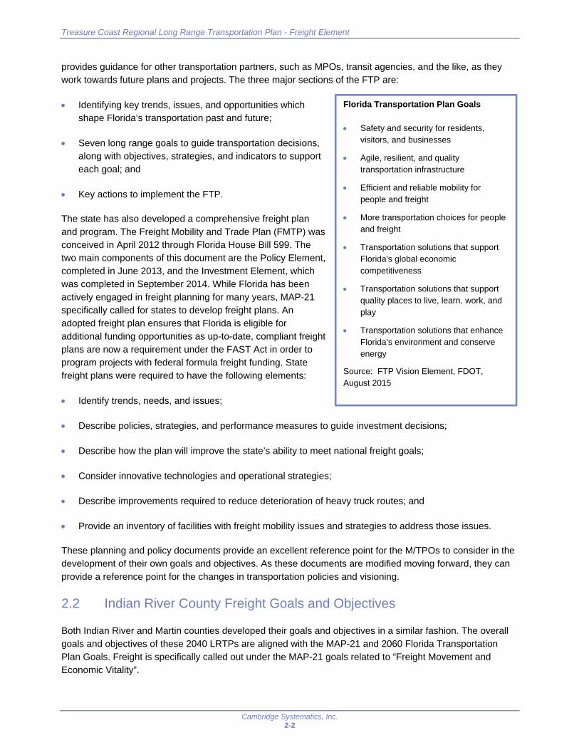
provides guidance for other transportation partners, such as MPOs, transit agencies, and the like, as they work towards future plans and projects. The three major sections of the FTP are:
Identifying key trends, issues, and opportunities which shape Florida’s transportation past and future;
Seven long range goals to guide transportation decisions, along with objectives, strategies, and indicators to support each goal; and
Key actions to implement the FTP.
The state has also developed a comprehensive freight plan and program. The Freight Mobility and Trade Plan (FMTP) was conceived in April 2012 through Florida House Bill 599. The two main components of this document are the Policy Element, completed in June 2013, and the Investment Element, which was completed in September 2014. While Florida has been actively engaged in freight planning for many years, MAP-21 specifically called for states to develop freight plans. An adopted freight plan ensures that Florida is eligible for additional funding opportunities as up-to-date, compliant freight plans are now a requirement under the FAST Act in order to program projects with federal formula freight funding. State freight plans were required to have the following elements:
Identify trends, needs, and issues;
Describe policies, strategies, and performance measures to guide investment decisions;
Describe how the plan will improve the state’s ability to meet national freight goals;
Consider innovative technologies and operational strategies;
Describe improvements required to reduce deterioration of heavy truck routes; and
Provide an inventory of facilities with freight mobility issues and strategies to address those issues.
These planning and policy documents provide an excellent reference point for the M/TPOs to consider in the development of their own goals and objectives. As these documents are modified moving forward, they can provide a reference point for the changes in transportation policies and visioning.
2.2 Indian River County Freight Goals and Objectives
Both Indian River and Martin counties developed their goals and objectives in a similar fashion. The overall goals and objectives of these 2040 LRTPs are aligned with the MAP-21 and 2060 Florida Transportation Plan Goals. Freight is specifically called out under the MAP-21 goals related to “Freight Movement and Economic Vitality”.
Florida Transportation Plan Goals
Safety and security for residents, visitors, and businesses
Agile, resilient, and quality transportation infrastructure
Efficient and reliable mobility for people and freight
More transportation choices for people and freight
Transportation solutions that support Florida's global economic competitiveness
Transportation solutions that support quality places to live, learn, work, and play
Transportation solutions that enhance Florida's environment and conserve energy
Source: FTP Vision Element, FDOT, August 2015

Treasure Coast Regional Long Range Transportation Plan - Freight Element
Cambridge Systematics, Inc. 2-3
Indian River County developed five goals for this LRTP, each with its own subset of objectives. While many goals related to safety, connectivity and access impact the movement of freight, only a handful relate directly to freight. Of these five, two are identified as directly related to freight movement, with a combined total of three objectives. These objectives focused on implementing multimodal improvements, improving the Strategic Intermodal System (SIS) network, and enhancing freight mobility, as summarized in Table 2.1.
Recommended enhancements for the Indian River MPO focus on the addition of freight specific objectives to the safety and preservation goals (goals 4 and 5). Each of these areas are impacted by freight operations. Safety concerns related to reducing crash and injury rates may be different for freight movements. For instance, an interchange ramp may be too steep for a truck to safely navigate, resulting in the truck rolling down an embankment. Crash rates here could be reduced by making improvements to the ramp. The preservation goal of Indian River is focused on pavement index ratings and the bridge network. As trucks are heavier than a typical passenger car, they can have a much greater impact on these facilities. Rehabilitating a roadway without an understanding of the truck traffic on that roadway may result in deteriorated conditions much faster than expected. An understanding of the routes heavily used by trucks can ensure that improvement projects are undertaken with all users in mind.
Table 2.1 Indian River County Freight Goals and Objectives
Goal 1: A connected, responsive, aesthetically pleasing, and efficient transportation system that meets the needs of Indian River County residents, visitors, and businesses
Objective 1.03: Enhance the grid roadway network by constructing an average of two centerline miles of new roadway corridors with appropriate multimodal improvements each year from 2020 to 2040
Objective 1.04: Enhance the FDOT’s Strategic Intermodal System (SIS) by constructing the Oslo Road Interchange at Interstate 95 by 2040
Goal 2: A transportation system that provides travel alternatives which enhance mobility for people and freight
Objective 2.06: Enhance freight mobility by improving an average of one centerline mile of roadway with appropriate multimodal improvements each year that are identified as serving freight movement
Source: Connecting Indian River County: Long Range Transportation Plan 2040 Update.
2.3 Martin County Freight Goals and Objectives
As mentioned above, Martin County identified and categorized the 2040 LRTP goals and objectives in a similar fashion as Indian River, albeit with some modifications. Martin County identified four overall goals, each of which has earmarked “Freight Movement and Economic Vitality” as a component of one or more objectives. Even though each of the four goals addresses freight or economics, only two goals specifically address freight, along with four objectives as shown in Table 2.2. Martin County did not identify specific policies to help reach these goals and objectives, but did identify performance measures used to determine how well the county is trending towards each objective.
Recommended enhancements for the Martin MPO focus on separating “freight movement” and “economic vitality” when screening existing objectives for relevance to freight. In looking at the objectives identified as addressing “freight movement and economic vitality”, only one specifically mentions freight or improving freight networks (Objective 1B: Support improvements to major roadway freight corridors). Others indirectly relate to freight by referencing overall performance (e.g., prioritize improvements that maintain acceptable

Treasure Coast Regional Long Range Transportation Plan - Freight Element
Cambridge Systematics, Inc. 2-4
travel performance), however, many relate to objectives that support economic vitality but not freight movement (e.g., increasing sidewalk coverage; improving transit commuter access to employment; and increasing the bike facility coverage). While freight movements are directly tied to economic vitality, a more suitable way to address this MAP-21 goal may be to separate the two components to ensure the specific freight goals of the county can be more readily realized and measured.
Table 2.2 Martin County Freight Goals and Objectives
Goal 1: An efficient multimodal transportation system that supports the local economy and maintains the quality of life
B. Support improvements to major roadway freight corridors
J. Support projects that enhance the local economy
L. Prioritize funding for projects that improve existing corridors that address multimodal transportation needs with context sensitive designs
Goal 2: A safe multimodal transportation system
B. Prioritize projects and programs that improve safety on corridors with highest number of crashes with fatal and incapacitating injuries by mode
Source: Moving Martin Forward: 2040 Long Range Transportation Plan.
2.4 St. Lucie County Freight Goals and Objectives
St. Lucie County developed the goals and objectives of the 2040 LTRP in a different manner. Goals and objectives are aligned with MAP-21. A total of six goals were developed, with three identified as related to “Movement of People and Freight”. However, only one goal with two objectives directly address the movement of freight. Table 2.3 shows the goals and objectives specific to freight.
Recommended enhancements for the St. Lucie TPO focus on separating the movement of freight and the movement of people, as well as adding freight objectives for Goals 3 and 6. Existing objectives under each already cover freight indirectly (e.g., Goal 3: maintain condition of existing transportation assets, improve efficiency of existing transportation services; Goal 6: improve safety of transportation system that may include incorporation of infrastructure in support of automated vehicles). The defined goals and objectives are utilized to score projects and determine their priorities. Without objectives specifically related to freight, the corresponding project ranking criteria are similarly not freight-focused. As a result, a freight project would score very low based on the existing project ranking criteria.
Table 2.3 St. Lucie County Freight Goals and Objectives
Goal 1: Provide for efficient transportation that serves local and regional needs and stimulates economic prosperity and growth
Enable people and goods to move around efficiently. Increase transportation options and improve access to destinations that support prosperity and growth.
Source: Go2040: St. Lucie TPO Long Range Transportation Plan.
Treasure Coast Regional Long Range Transportation Plan - Freight Element
Cambridge Systematics, Inc. 3-1
3.0 Freight and Logistics System Elements
The freight system of the Treasure Coast region is a multimodal network consisting of roadways, railways, airports, a seaport, waterways, and other supporting infrastructure such as warehouses, distribution centers, and truck parking facilities. The network is shown in Figure 3.1 with further information on each of these components detailed in the following subsections.
3.1 Key Freight Roadways
A well connected network of roadways is pivotal to the efficient movement of goods and services. While most routes will be used by trucks in some capacity for local deliveries, only a portion of the overall system is considered critical for freight movements. Without efficient movements on these roadways, other local streets may suffer from congestion as drivers attempt to find alternative routes. The three designations included here are:
Strategic Intermodal System Roadways (SIS)
National Highway Freight Network (NHFN)
Locally designated truck routes
3.1.1 Key Roadway Designations
Strategic Intermodal System Roadways
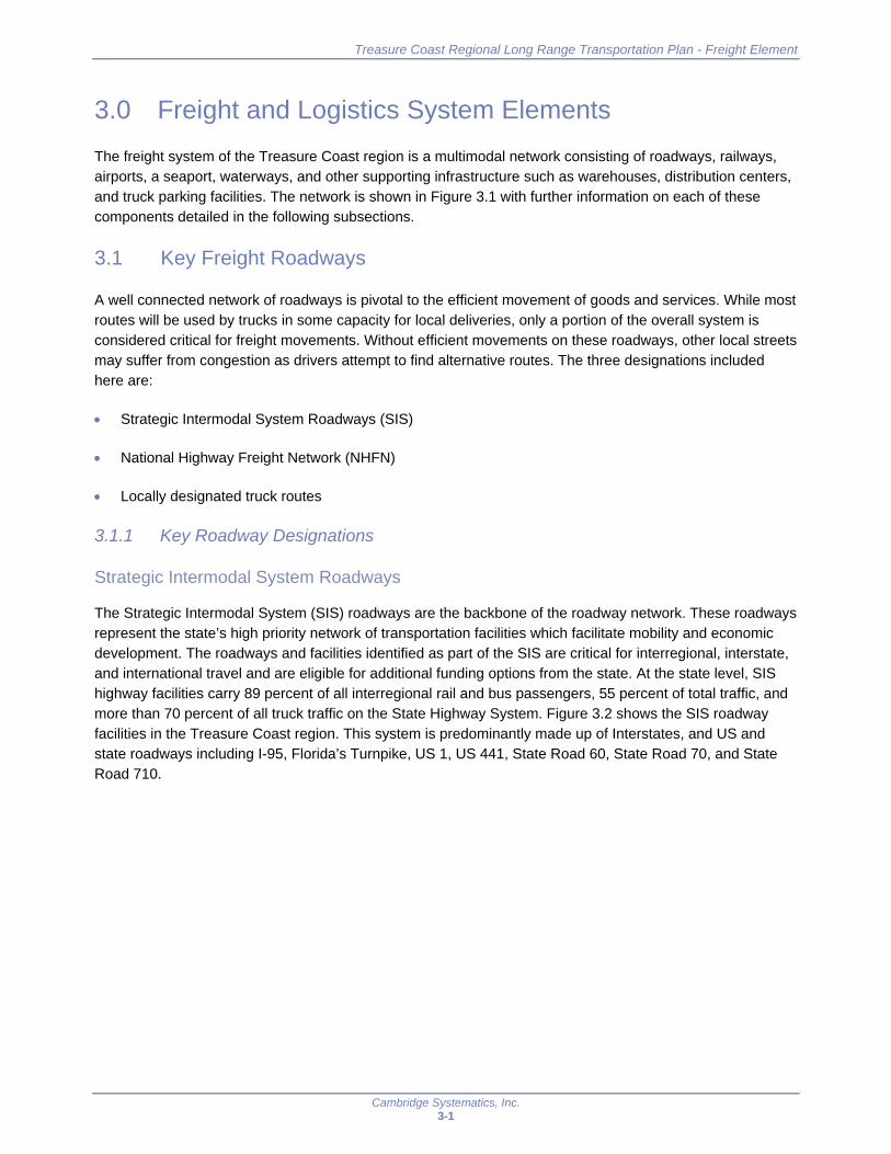
The Strategic Intermodal System (SIS) roadways are the backbone of the roadway network. These roadways represent the state’s high priority network of transportation facilities which facilitate mobility and economic development. The roadways and facilities identified as part of the SIS are critical for interregional, interstate, and international travel and are eligible for additional funding options from the state. At the state level, SIS highway facilities carry 89 percent of all interregional rail and bus passengers, 55 percent of total traffic, and more than 70 percent of all truck traffic on the State Highway System. Figure 3.2 shows the SIS roadway facilities in the Treasure Coast region. This system is predominantly made up of Interstates, and US and state roadways including I-95, Florida’s Turnpike, US 1, US 441, State Road 60, State Road 70, and State Road 710.

Treasure Coast Regional Long Range Transportation Plan - Freight Element
Cambridge Systematics, Inc. 3-2
Figure 3.1 Treasure Coast Freight Network
•
FLORIDA'S TURNPIKE
• •
ST LUCIE
• • Lake Okeechobee .. ,
Legend * Private Trucking Faci lity * RestAreas
a Airport
E:3 SIS Seaport
[:I RailYard
-- Regional Freight Roadways
• • • SIS Waterways
.........+- Rail
- Freight Facilities
Conservation Lands
'-·
L
Vero Beach ,::~~ ;';;iii-, Regional Airport Atlantic Ocean
Treasure Coast International Airport
Witham Field Airport
MARTIN
' • ,, 5 10
•----=====Miles

Treasure Coast Regional Long Range Transportation Plan - Freight Element
Cambridge Systematics, Inc. 3-3
Figure 3.2 SIS Roadways in the Treasure Coast Region
Source: Florida Department of Transportation.
·1 INDIAN RIVER
Atlantic Ocean 60
I
FLORIDA'S TURNPIKE
i L
ST LUCIE
Legend
-- SIS Roadways
MAR TIN
MPO 0----•5====10
Miles

Treasure Coast Regional Long Range Transportation Plan - Freight Element
Cambridge Systematics, Inc. 3-4
National Highway Freight Network
The Federal Highway Administration (FHWA) is an agency within the U.S. Department of Transportation (USDOT) which supports State and local governments in the design, construction, and maintenance of the Nation’s highway system. To ensure the consistency and continuity of this support, long term federal transportation funding is a critical element so that States and local governments can appropriately plan for anticipated funding. The most recent transportation bill, Fixing America’s Surface Transportation (FAST) Act, was the first federal law in over a decade to provide long-term funding for surface transportation. Signed into law in December 2015, the FAST Act authorizes $305 billion for transportation spending over fiscal years 2016 through 2020.
For freight planning, the FAST Act has specifically designated federal money for freight improvement projects. To focus on the elements of the network most critical for the movement of goods, the FAST Act directed FHWA to establish a National Highway Freight Network (NHFN). This network ensures the strategic use of Federal resources and policies to improve the performance of the Nation’s freight system. The NHFN is comprised of the following four subsystems which have their own designation criteria:
Primary Highway Freight System (PHFS)
Those portions of the Interstate System not part of the PHFS
Critical Rural Freight Corridors (CRFCs)
Critical Urban Freight Corridors (CUFCs)
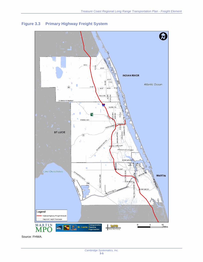
Primary Highway Freight System
The Primary Highway Freight System (PHFS) is a critical component of the freight transportation network. This network was established through significant amounts of stakeholder feedback from local, regional, and state entities based on a preliminary designation by FHWA. The designation completed as part of the FAST Act built on the initial network designation process undertaken as part of the MAP-21 highway only primary freight network (PFN) under 23 U.S.C. 167(d). Nationally, the system consists of 41,518 centerline miles, including 37,436 centerline miles of Interstate and 4,082 centerline miles of non-Interstate roads. The state of Florida as a whole comprises 1600.69 miles of this, including 1538.92 miles of major corridors with the remainder being comprised of intermodal connectors. FHWA is charged with re-designating this system every five years to reflect changes in freight flows.
Within the Treasure Coast Region, this network includes I-95 through the entire region. In addition, the Port of Fort Pierce has an intermodal connector. At 6.11 miles, this connector includes SR 70 and US 1 from I-95 to the Port entrance. A map of the PHFS in the region is shown in Figure 3.3.
Treasure Coast Regional Long Range Transportation Plan - Freight Element
Cambridge Systematics, Inc. 3-5
Figure 3.3 Primary Highway Freight System
Source: FHWA.
95 ST
·1 I
FLORIDA'S TURNPIKE
-• I
ORANGE AVE
L ST LUCIE
.. Lake Okeechobee
Legend
-- National Highway Freight Network
-- Regional Freight Roadways
MAR TIN
MPO gJ ~ 0 T ransportation
St. Lucie Planning Or~an1zatt0n
I . , ......_ __
INDIAN RIVER
Atlantic Ocean
0 10 •----===== Miles
5

Treasure Coast Regional Long Range Transportation Plan - Freight Element
Cambridge Systematics, Inc. 3-6
Other Interstate Portions not on the PHFS
As the PHFS limited the total mileage designated, not all interstates across the country were included in this subsection. However, interstates are critical to the movement of goods and services. The purpose of this subsection is to ensure that all interstate portions are included as part of the overall NHFN. Within Florida, 54.63 miles of interstate are included in this subsection. However, as all interstate portions in the Treasure Coast region have been included as part of the PHFS, no further segments are identified in this subsection.
An important note on the other interstate portions not on the PHFS, the total mileage within the state impacts funding availability for these roadways. For states whose mileage is greater than or equal to two percent of the total PHFS mileage of all states, funding may only be used on the PHFS, Critical Rural Freight Corridors, and Critical Urban Freight Corridors. Funds may be not used on these other interstates not included as part of the PHFS. Florida is a high mileage state, meaning that the State cannot use the funding on these other interstate portions not on the PHFS. While this does not impact the Treasure Coast region, it is an important consideration to remember.
Critical Rural Freight Corridors
Critical Rural Freight Corridors (CRFCs) are an important component of the NHFN as they serve as part of the first and last mile connectivity. These public roadways help to provide links between freight generators and a distribution pathway. The CRFCs must be outside the adjusted boundaries of any urbanized area, with the Census Bureau defining an urbanized areas as one with a population of at least 50,000. In addition, a roadway must meet one or more defined seven elements.
The identification of these facilities puts an emphasis on enhancing first and last mile connectivity. A State may designate the greater amount of 150 miles of highway or 20 percent of the PHFS mileage in the State. Within the State of Florida, 320.14 miles may be designated as CRFCs. For this effort, the State is responsible for designating the public roads in accordance with section 1116 of the FAST Act. Florida has worked to designate these corridors and at present no CRFCs are located in the Treasure Coast Region. However, SR 60 has been designated as a “planned” CRFC.
Seven Elements for CRFC Designation
(A) is a rural principal arterial roadway and has a minimum of 25 percent of the annual average daily traffic of the road measured in passenger vehicle equivalent units from trucks (FHWA vehicle class 8 to 13);
(B) provides access to energy exploration, development, installation, or production areas;
(C) connects the PHFS or the Interstate System to facilities that handle more than:
− 1. 50,000 20-foot equivalent units per year; or
− 2. 500,000 tons per year of bulk commodities;
(D) provides access to:
− 1. a grain elevator;
− 2. an agricultural facility;
− 3. a mining facility;
− 4. a forestry facility; or
− 5. an intermodal facility;
(E) connects to an international port of entry;
(F) provides access to significant air, rail, water, or other freight facilities in the State; or
(G) is determined by the State to be vital to improving the efficient movement of freight of importance to the economy of the State.
Source: FHWA.

Treasure Coast Regional Long Range Transportation Plan - Freight Element
Cambridge Systematics, Inc. 3-7
Critical Urban Freight Corridors
Similar to the CRFCs, States are also charged with designating Critical Urban Freight Corridors (CUFCs) in consultation with their MPOs. Specifically, for an urbanized area with a population greater than 500,000, MPOs are responsible for designating the CUFC. For areas with a population of less than 500,000, the State is responsible for designating the CUFC in consultation with the MPO. Regardless of the population size, a public road designated as a CUFC must be within an urbanized area and meet one or more of four defined elements.
As with the CRFCs, States and MPOs are encouraged to consider first and last mile connections for high volume freight corridors and/or freight intensive land uses. Designation of the CUFC is limited to the maximum of 75 miles of highway or 10 percent of the PHFS mileage in the State, whichever is greater. Within the state of Florida, 160.07 miles is eligible to be designated as part of the CUFCs. Florida has worked to designate these corridors and at present none are located in the Treasure Coast region.
While the Treasure Coast region does not currently have CUFCs or CRFCs, it is important to remember that designations and certifications of these routes may be provided to FHWA on a rolling basis. Routes may be removed and added at any time so long as the requirements are met and the mileage does not exceed the maximum allowable limit.
Regionally Significant Roadways
Some of the counties of the Treasure Coast region have worked to designate truck routes within their boundaries. Specifically, St. Lucie and Indian River have made efforts to identify key truck routes. This does not prevent trucks from traveling on other roadways but they are encouraged to use these roadways. Martin County has not made such a designation. The identified roadways are part of the regionally significant roadway network defined through the RLRTP development process.
3.1.2 Key Truck Corridors
One way to determine the most significant truck corridors in the region is by looking at the volume of trucks traveling on the roadways. Based on data from FDOT, Figure 3.4 shows the volume of trucks moving on the SIS roadway network in the Treasure Coast region with Table 3.1 supplementing this with detail on the top ten roadway segments by truck volume. Daily truck volumes range from 7,200 to almost 9,000. The highest volumes are seen along I-95, in particular on segments where it crosses with Florida’s Turnpike. One explanation for this may be truck drivers’ desire to avoid tolled roadways where possible. Therefore, the drivers are switching from Florida’s Turnpike to I-95 when able in order to avoid continued tolls. Similarly, drivers may also be switching to Florida’s Turnpike after these points and lowering the overall truck volumes seen on the parallel roadways.
Four Elements for CUFC Designation
Connects an intermodal facility to:
− The PHFS;
− The Interstate System; or
− An intermodal freight facility;
Is located within a corridor of a route on the PHFS and provides an alternative highway option important to goods movement;
Serves a major freight generator, logistics, center, or manufacturing and warehouse industrial land; or
Is important to the movement of freight within the region, as determined by the MPO or the State.
Source: FHWA.

Treasure Coast Regional Long Range Transportation Plan - Freight Element
Cambridge Systematics, Inc. 3-8
Figure 3.4 Truck Volumes on Treasure Coast Regional Roadways
Source: Florida Department of Transportation, 2016.
·1
ST LUCIE
Lake Okeechobee
Legend
TruckAADT
- <1 ,000
- 1,000 - 2,500
2,500 - 5,000
- 5,000 - 7,500
- > 7,500
-- Regional Freight Roadways
95ST
•
INDIAN RIVER
Atlantic Ocean
MARTIN
0 10 •----====::::J Miles 5

Treasure Coast Regional Long Range Transportation Plan - Freight Element
Cambridge Systematics, Inc. 3-9
Table 3.1 Top 10 Highest Volume Regional Roadways by Truck Traffic
Roadway From To County AADT AADTT Truck Percent
I-95 Indian River County Line Orange Ave St. Lucie 46,500 8,975 19.3%
I-95 SW High Meadow Ave SW Kanner Hwy Martin 63,000 8,694 13.8%
I-95 SW Kanner Hwy SE Bridge Rd Martin 73,500 8,159 11.1%
I-95 Orange Ave Graham Rd St. Lucie 54,502 7,739 14.2%
I-95 Graham Rd Okeechobee Rd St. Lucie 54,502 7,739 14.2%
I-95 Martin Hwy SW High Meadow Ave Martin 51,500 7,262 14.1%
I-95 Okeechobee Rd Midway Rd St. Lucie 69,500 7,159 10.3%
I-95 Midway Rd St. Lucie W Blvd St. Lucie 61,500 6,581 10.7%
I-95 St. Lucie County Line Martin Hwy Martin 59,325 6,288 10.6%
I-95 Brevard County Line Fellsmere Rd Indian River 43,500 5,916 13.6%
Source: Florida Department of Transportation, 2016.
In addition to looking at overall truck volumes, it also is important to look at the percent of total traffic represented by trucks. This helps further refine and evaluate key truck corridors. Figure 3.5 illustrates the percent trucks along the SIS and Table 3.2 provides the top ten roadways based on percent truck. Note the list of roadways is different from the top ten roadways based on total truck volume. Truck percent ranges from 20 to 43 percent as compared to 10 to 19 percent when looking at the highest volume roadways.

Treasure Coast Regional Long Range Transportation Plan - Freight Element
Cambridge Systematics, Inc. 3-10
Figure 3.5 Truck Share of Traffic on Treasure Coast Regional Roadways
Source: Florida Department of Transportation, 2016.
ST LUCIE
Lake Okeechobee
Legend
Truck Percentage - <5%
- s-10%
10-15%
- 15-20%
- :> 20%
MAR TIN
MPO
-· L
II ORANGE AVE
...
•
INDIAN RIVER
Atlantic Ocean
MARTIN
0 10 -----=====Miles
5

Treasure Coast Regional Long Range Transportation Plan - Freight Element
Cambridge Systematics, Inc. 3-11
Table 3.2 Top 10 Highest Volume Regional Roadways by Truck Share of Traffic
Roadway From To County AADT AADTT Truck Percent
US 98 SW Kanner Hwy Palm Beach County Line Martin 5,000 2,155 43.1%
US 98 Okeechobee County Line SW Kanner Hwy Martin 2,500 800 32%
SR 60 Osceola County Line Blue Cypress Rd Indian River 5,583 1,535 27.5%
SR 60 Blue Cypress Rd CR 512 Indian River 5,583 1,535 27.5%
SR 710 SW Kanner Hwy Palm Beach County Line Martin 7,400 1,983 26.8%
SR 60 94th Dr I-95 Indian River 8,700 2,297 26.4%
SR 710 Okeechobee County Line SW Allapattah Rd Martin 7,100 1,711 24.1%
SR 60 CR 512 94th Dr Indian River 4,600 984 21.4%
SR 60 94th Dr 90th Ave Indian River 10,200 2,173 21.3%
SR 710 SW Allapattah Rd SW Kanner Hwy Indian River 10,900 2,180 20%
Source: Florida Department of Transportation, 2016.
3.2 Key Freight Railroads
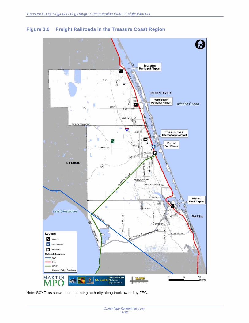
The history of the development on the East Coast of Florida is synonymous with the name of Henry Flagler, whose ambition was to expand his railroad network throughout the state of Florida in the late 19th century. This ambition has helped to shape the current rail infrastructure in place today. There are three entities operating the freight railroad network in the Treasure Coast region: Florida East Coast Railway (FEC), South Central Florida Express railroad (SCXF), and CSX Transportation. Figure 2.3 shows these three railroads operating within the Treasure Coast Region. The grey lines show SIS roadway network for reference. Note the SCXF currently has operating authority on FEC’s K Branch from Fort Pierce to South Bay. FEC, as owner, also has operating rights along this corridor..
Treasure Coast Regional Long Range Transportation Plan - Freight Element
Cambridge Systematics, Inc. 3-12
Figure 3.6 Freight Railroads in the Treasure Coast Region
Note: SCXF, as shown, has operating authority along track owned by FEC.
I FLORIDA'S TURNPIKE
ST LUCIE
Lake Okeechobee
Legend =-~ SISSeaport
t"J RailYard
Railroad Operators
- CSX
- FEC
- SCXF
Regional Freight Roadways
-· L
955T
/
\ I 20ST
I
ORANGE AVE
MAR TIN
MPO g]~ 0 Transporta t ,on
St. Lucie Pla nn,~g O,gan1zat1on
Vero Beach 'iiiiiiii\---";;;;r, Regional Airport Atlantic Ocean
I .. ....._ ,._ _
Treasure Coast International Airport
Witham Field Airport
MARTIN
10 •----===== Miles 0 5

Treasure Coast Regional Long Range Transportation Plan - Freight Element
Cambridge Systematics, Inc. 3-13
3.2.1 Florida East Coast Railway
The Florida East Coast Railway (FEC) is a 351-mile Class II freight rail system located along the east coast of Florida. It is the only north-south mainline along the Atlantic coast between Miami and Jacksonville. FEC is the primary rail service provided in the Treasure Coast region, operating 76 miles of freight rail. FEC transports a mix of freight including intermodal containers and trailers, bulk/carload, and box car/general merchandise. FEC provides direct and exclusive service to PortMiami, Port Everglades and Port of Palm Beach, as well as a network of terminals. In the Treasure Coast region, FEC serves the Port of Fort Pierce and the cities of Port St. Lucie and Vero Beach. In addition to regular freight service, the development of the Brightline express passenger rail service by All Aboard Florida will add additional trains to the corridor.1
3.2.2 CSX
CSX, one of North America’s Class I railroads, also operates in the Treasure Coast region. In Florida, CSX operates and maintains more than 2,800 miles of track and handles more than 1.1 million carloads of freight on the state’s rail network. In the Treasure Coast region, CSX operates 25 miles of railway in the southwest corner of Martin County where it provides limited carload service. CSX provides carload/bulk and box car/general merchandise service through the region with limited stops at rail served properties in Martin County.
3.2.3 South Central Florida Express
Another railroad company operating in the Treasure Coast region is South Central Florida Express railroad (SCXF). SCXF is a Class III railroad serving the agricultural industries of South Central Florida. The railroad serves 26 customers and hauls cut cane, bulk raw sugar, packages and bulk-refined sugar, fertilizer, molasses, pulpwood logs, rolled paper, and farm equipment. SCXF has been owned and operated by the U.S. Sugar Corporation since 1994. The railroad currently owns a 98-mile section between Sebring and Pahokee. The railroad also owns a branch line running south of Lake Harbor and then turning east into the cane fields south of Belle Glade. SCXF operates on 171 route miles on both sides of Lake Okeechobee in South Florida. The line on the west side of Lake Okeechobee interchanges with CSX at Sebring and, through a lease agreement, operates over 51 miles of FEC track to the Atlantic Coast where it connects to the FEC main line at Fort Pierce. SCXF has haulage rights on the FEC to its Jacksonville interchanges with CSX and Norfolk Southern. SCXF operates on 45 miles of railway in the Treasure Coast region.
1 http://www.allaboardflorida.com/

Treasure Coast Regional Long Range Transportation Plan - Freight Element
Cambridge Systematics, Inc. 3-14
3.3 Seaports and Waterways
3.3.1 Port of Fort Pierce
Established in 1918, the Port of Fort Pierce, which lies within the City of Fort Pierce’s limits, falls under the jurisdiction of St. Lucie County and the five County Commissioners. The County owns 20 acres at the port, adjacent to 67 undeveloped privately owned acres and 12 acres which house the privately owned Fort Pierce Yachting Center, formerly known as the Indian River Terminal. This port has historically served a hinterland including St. Lucie, Indian River, Okeechobee, Highlands, Hendry, Glades, and Martin counties. The port has traded with nearby partners in the Caribbean Basin and the Bahamas as well as the Far East and Europe. No container cargo has been handled at the Port of Fort Pierce since FY 2011/12, however the port does continue to export break, neo and dry bulk cargo via barges. The port updated its Master Plan in December 2015 and continues to explore its strategic opportunities.
The Florida Seaport Five-Year Capital Improvement Program (CIP) for 2015-2016 through 2019/2020 identifies several projects for the Port of Fort Pierce. The port continues to work on infrastructure and economic development projects to attract business to the region. Currently, the port is midway through the construction phase of the 2nd Street project which runs the length of the port (from north to south) and serves as the primary entrance road to the port. This major project includes widening the roadway to accommodate freight, moving and burying power lines to accommodate Oversize & Overweight trucks, adding a truck “turn-around” loop at the northern end, installing upgraded power, water, sewer, and natural gas mains to serve the port areas as well as a storm water collection and treatment system. Construction is anticipated to be complete by April 2018.
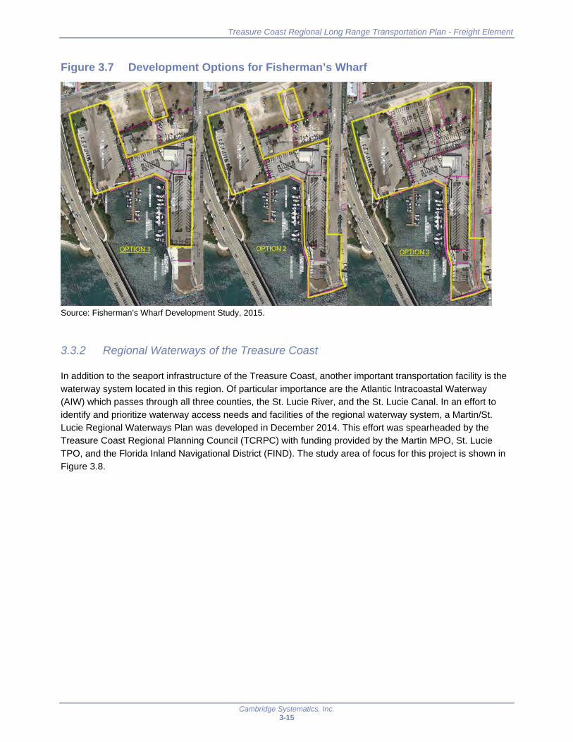
Another significant development underway at the port is the development of Fisherman’s Wharf. The objective of developing this area is to serve as a “Transition Zone” between the City’s Downtown to the south and the more industrial area to the north. A recently completed study looked at various options for optimal development for this portion of land, as shown in Figure 3.7. Option 2 was selected, in a comparative evaluation process in close collaboration with the City and County, as the optimal land configuration. As a result of this study, the County was able to apply for and successfully receive funding through the Florida Seaport Transportation and Economic Development Program (FSTED) for two small properties totaling 0.44 acres as well as design funds for Fisherman’s Wharf bulkhead and dredging project. It is the intent of the County to move the design project forward and apply for additional funds from FSTED for construction of the bulkhead and dredging project.
The Port is also focusing it’s efforts on the County owned Harbour Pointe parcel at the northern end of the port. They are exploring options on developing the land to best fit the region and community as well as provide for economic development in the area.
Treasure Coast Regional Long Range Transportation Plan - Freight Element
Cambridge Systematics, Inc. 3-15
Figure 3.7 Development Options for Fisherman’s Wharf
Source: Fisherman’s Wharf Development Study, 2015.
3.3.2 Regional Waterways of the Treasure Coast
In addition to the seaport infrastructure of the Treasure Coast, another important transportation facility is the waterway system located in this region. Of particular importance are the Atlantic Intracoastal Waterway (AIW) which passes through all three counties, the St. Lucie River, and the St. Lucie Canal. In an effort to identify and prioritize waterway access needs and facilities of the regional waterway system, a Martin/St. Lucie Regional Waterways Plan was developed in December 2014. This effort was spearheaded by the Treasure Coast Regional Planning Council (TCRPC) with funding provided by the Martin MPO, St. Lucie TPO, and the Florida Inland Navigational District (FIND). The study area of focus for this project is shown in Figure 3.8.

Treasure Coast Regional Long Range Transportation Plan - Freight Element
Cambridge Systematics, Inc. 3-16
Figure 3.8 Martin/St. Lucie Regional Waterways Plan Study Area
Source: 2014 Martin and St. Lucie Regional Waterways Plan.
The AIW serves as a mixed use transportation corridor in Martin and St. Lucie counties. Cargo services are limited to infrequent barge traffic to serve specific customers. Barge service provides products to specific industrial hubs (power plants). The region is home to two navigable inlets in Stuart and Fort Pierce. Cargo volumes from Jacksonville to Miami, fluctuate annually, driven largely by petroleum movements. There has been a significant reduction in recent years due to a declining demand for petroleum products. This is largely due to the conversion of Florida Power and Light Company (FPL) plants from petroleum to natural gas. Cargo trends along the AIW are shown in Table 3.3 below for 2007 through 2014. Recent operations are extremely limited and consist of primary manufactured goods and manufactured equipment and machinery.
Dredging Responsibility N il'IW Nor1h of Fort Pltirc• : 12 f••t
ICWW South Of Fort Pltrct: 10 IHI
SI Lud• Rivtor/Sou1h Forkl0k•• chob1e WW: 8 felt
,NM•nat.•• Poc:kel - m1ln fflann• I: 10 fie.I
AGEl«:Y AREA OF RESPONSlll!UTY
Tho USACli ,s ,.__ kit mirna,.,,o thlt
=.:..~~=A~,::, .,lf!.I FIND I• m. 1!,,_ _lo,t/JtAJWand OWWand.-.,,__.,,,pw«IIASACE
LOCM-•~Y 1n ,c:1>1••- "1 ma.tl>I 11\'JQ all cxher .-wayi
T. L CIE
-_, P ,L
.... .......
M RTI
JUPITER
DREDGING RESPONSIBILITIES & PERMITTED DEPTHS

Treasure Coast Regional Long Range Transportation Plan - Freight Element
Cambridge Systematics, Inc. 3-17
Table 3.3 Atlantic Intracoastal Waterway Cargo Volumes, 2007 through 2014 Jacksonville, FL to Miami, FL
Year Total Tons Petroleum Tons Percent Petroleum
2007 458,639 454,337 99%
2008 75,071 66,746 89%
2009 55,252 49,452 90%
2010 80,217 61,806 77%
2011 12,243 5,800 47%
2012 1,291 - 0%
2013 1,737 - 0%
2014 1,241 - 0%
Source: http://www.navigationdatacenter.us/wcsc/webpub14/Part1_WWYs_tonsbyTT_Dr_Yr_comm2014_2010.htm http://www.navigationdatacenter.us/wcsc/webpub11/Part1_WWYs_tonsbyTT_Dr_Yr_commCY2011‐2007.HTM
While the cargo movements along the AIW have decreased, the waterways also are home to a successful yacht building and service industry. The waterways provide direct water access for landside facilities. For example, American Custom yachts Inc. is located along the St. Lucie Canal between Florida’s Turnpike and I-95, as shown in Figure 3.9. Increased rail service along the FEC corridor (freight and passenger) has the potential to impact waterborne vessels at the Loxahatchee and St. Lucie River bridges including barge traffic, other commercial operations, and recreational uses.
Figure 3.9 Example of Yacht Industry
Source: http://www.americancustomyachts.com/
3.4 Airports
The Treasure Coast region is home to a network of airports. These airports consist largely of general aviation airports. Commercial flights, foreign trade zone (FTZ) status, customs services, and economic development plans set a few of the airports apart, as described below.
Florida's Premier Custom Yacht Builder and Marine Service Facility
More than just a boatyard, American Custom Yachts' 63-acre marine facility accommodates the construction of ACY's worldfamous custom sportfishermen and provides a full range of marine services on site , including yacht repair, repowering and refitting, complete painting services and storage for over 300 vessels. Our reputation is built on long-lasting relationships with our customers and business associates. Our customers know they can come to us anytime with any problem, just like family. Whatever your marine service needs are, big or small , let us know. We'll treat you right at home.

Treasure Coast Regional Long Range Transportation Plan - Freight Element
Cambridge Systematics, Inc. 3-18
3.4.1 Vero Beach Regional Airport
Vero Beach Regional Airport, formerly known as Vero Beach Municipal Airport, is located in Indian River County and is owned and operated by the City of Vero Beach. The airport has three operational runways with lengths of 3,504’, 4,974’, and 7,314’. Operations at this airport are predominately General Aviation Local and General Aviation Itinerant however there are some air taxi and military operations as well. Commercial service began on December 10th, 2015 at this airport for the first time in nearly 20 years. Total annual operations at this facility exceed 250,000. The city of Vero Beach worked with the Federal Aviation Administration (FAA) and the Florida Department of Transportation (FDOT) to prepare an Airport Master Plan which was completed in June 2016 and will guide the future of the airport. The master plan prioritizes maximizing development to complement existing infrastructure, particularly in the short term; protecting lands for future development opportunities; and expansion and development of aeronautical needs in the Midfield and Northwest cores. Figure 3.10 illustrates the facilities and improvements.
Figure 3.10 Planned Airport Facilities and Infrastructure Improvements at Vero Beach Regional Airport
Source: Plan for Sustaining Vero Beach Regional Airport, Executive Summary, June 2016.
3.4.2 Treasure Coast International Airport and Business Park
The Treasure Coast International Airport and Business Park, formerly referred to as the St. Lucie County International Airport, is owned and operated by the St. Lucie County Board of County Commissioners. The airport encompasses 3,660 acres and contains three operational runways with lengths of 4,000’, 4,755’, and 6,492’. Operations at this airport are predominately General Aviation Local and General Aviation Itinerant with total operations reaching nearly 200,000 annually. The most recent Master Plan Update for this airport was completed in June 2011 to identify a long range, orderly direction for airport development. Recommended developments from this plan, shown in Figure 3.10, include capacity for future industrial
Planned Airport Facilities and Infrastructure Improvements
To mott tht-fuL.i,toll'lll,II\IIDn lltlN'lh,dtwlolJmu,t priomyw .. ,9hifti to.iebwherr lnlrnllll(Nf. it'(lm, .,,.. r1 ........ lilbkl 10 «(ommod.lt• ihor! lftffl dM.k')prr'Wlrt111,
Som,, ..JrfiNd jmprowm,,nh Mrt ldfllr1W 10 UM! .addltloNI .aln;oft 1t.or-q 4ik:lhlt6. In oldditio,f\ "°""' co,,~idef"•b, wen eM,, to l)l'Ole<:t thf lilnd !lffdtct 10 WI"" flJWrt u:hedultd •Ir w,lft fMlloilltt . u dlrn,md w..rum., Ill
MfOfl,Wlk:.tJ need, ... amf'l'llty MfWd u.thttAlrPOd .-,Noo,,, Mldrif,ldA'A.llloo .-nd WtttC-0,,,mucWr..irktortt, Tht ,hon olJid mkl 141m,H.ron.M1tlul flftd~ I)!
1hlt NJJXlf1 will conll~ 10 i.. prinurf., arcomrnodatf'd irl l~ (04'9:\- In .addlillon 10 h•'MIII tOffif, 1nr1;11\!1\,1Ch1rf aJructv In flLM•. IN MIClll.!ld Alll;uJon cor• otffof\ lhe poulbllity lO f!ll1),l,l)d to lht! WNI Uld 11CUlffln'llld,Ut .i.ddltlOfl.11 I.K1lillle'I, both tor1m,ill.a.od!M9t'.11Jrcr.11fl.
t..-.~, llw: dewklpm,nt of Norl~I C0ffl will alloi,ri, Lt. Airport to tr'INII ih ll'>nu wm If~ need,, 'M1h dlffCI .«in, to thil' fWO ITMIMl1 rvnwm., r..,_, lOffllr:.Urtlll 'Wl!l'fl kftnillfltd ., p,M1 of 1h41 nu.,u,r pi.Ulnl"9 Uud~ j,o, 1h.11 wt, Mid Luld~ .Kain «Miki bit pm,,,jderd lhraugh Ord AWfl!H. 1t11, tote ~ •h.O ldtfltiditd Ha POIINitUII Mltlo bui'd a l;&fgtr ~ ~~,.-.1 .. mln.ll w,tw,n
1hedanwnde:,c««111heup;ldtyofthec:unffltl.adliilttt.ThlPfopowd'oW1nJ11WutlliUI dtMlo~ •nd illnotllitled llrfl!kt W.,rn1'Yt:1Uttl lll't d1Jlk,lld tNtloiii,,
I NIL'W •orn •t1 III JfiOl1\ •nd ""4d IP,lllt
2 N......, ,,in1,1,t1 Jl~ng,m
J fli.llf#•._, [ utu,,kN!. wd wti:h1111~, \[ul •tul Wet.ti
4 •unw,1.y Ull Ull .,.,tq.,nl,...
5 lllt-lvb No11t1 illtM04J.
6 Tf'tm>!Ud llp,QUdl'" lr.ir p.o\ltnq ... r 1 ... Mo".
1 llluli~um,nl ,....,..,_"W C
II lltlwlb l•~1r,11,-''I' I
9 RtcorHIIVI t Cfnr,, -'Pfon
10 lon11 t"rm totr1m,n.1,1 p,UHM!JII lnml'1,,1,1 •1111 •vi,! o,up~nf¥11U,~
@r .... 1111uvlli , ~1,n,t0n ! 111,uw•·•w ,1 n n1t1n1lon 10 \ , l'iO It
lltlwlb$ou1h....,.,1Apron
o.nmuu NN r,ao- 1Mn11Ao
Treasure Coast Regional Long Range Transportation Plan - Freight Element
Cambridge Systematics, Inc. 3-19
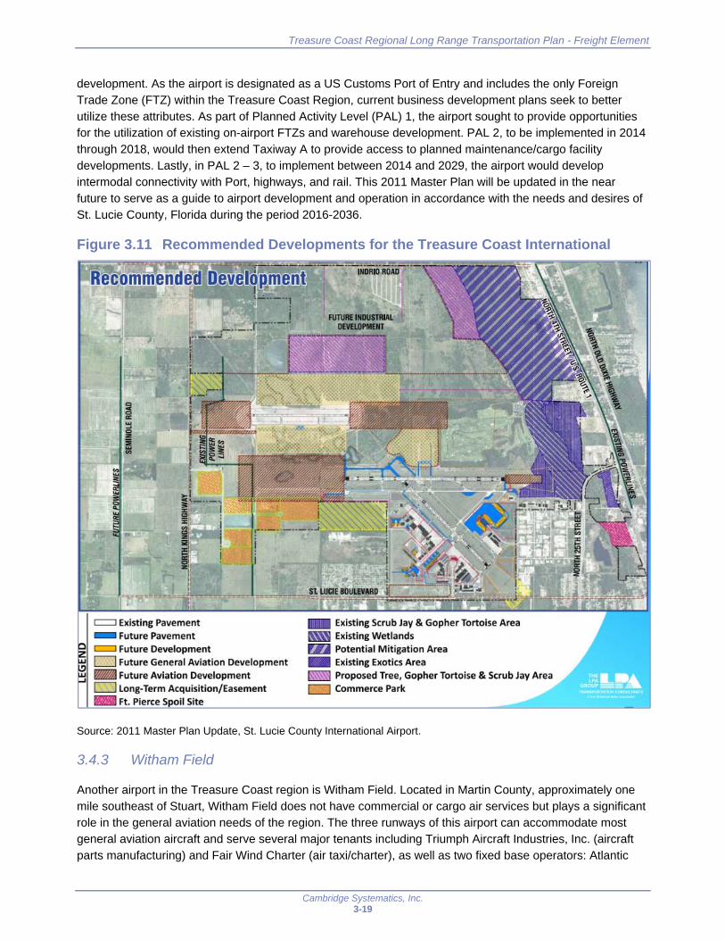
development. As the airport is designated as a US Customs Port of Entry and includes the only Foreign Trade Zone (FTZ) within the Treasure Coast Region, current business development plans seek to better utilize these attributes. As part of Planned Activity Level (PAL) 1, the airport sought to provide opportunities for the utilization of existing on-airport FTZs and warehouse development. PAL 2, to be implemented in 2014 through 2018, would then extend Taxiway A to provide access to planned maintenance/cargo facility developments. Lastly, in PAL 2 – 3, to implement between 2014 and 2029, the airport would develop intermodal connectivity with Port, highways, and rail. This 2011 Master Plan will be updated in the near future to serve as a guide to airport development and operation in accordance with the needs and desires of St. Lucie County, Florida during the period 2016-2036.
Figure 3.11 Recommended Developments for the Treasure Coast International
Source: 2011 Master Plan Update, St. Lucie County International Airport.
3.4.3 Witham Field
Another airport in the Treasure Coast region is Witham Field. Located in Martin County, approximately one mile southeast of Stuart, Witham Field does not have commercial or cargo air services but plays a significant role in the general aviation needs of the region. The three runways of this airport can accommodate most general aviation aircraft and serve several major tenants including Triumph Aircraft Industries, Inc. (aircraft parts manufacturing) and Fair Wind Charter (air taxi/charter), as well as two fixed base operators: Atlantic
- Future Pavement c::::J Future Development D Future General Aviation Development
- Future Aviation Development D Long-Term Acquisition/Easement ~ Ft. Pierce Spoil Site
- Existing Scrub Jay & Gopher Tortoise Area Ex.isting Wetlands
r'n Potential Mitigation Area - Existing Exotics Area ~ Proposed Tree, Gopher Tortoise & Scrub Jay Area c=J Commerce Park

Treasure Coast Regional Long Range Transportation Plan - Freight Element
Cambridge Systematics, Inc. 3-20
Aviation and Stuart Jet Center. Efforts to expand this airport’s attractiveness to users has included attempts to build a U.S. Customs facility that would serve international air and marine travelers. This would allow users to clear customs at Witham Field, rather than using facilities in either West Palm Beach or Fort Pierce. This facility is moving forward with the County Commission’s vote to apply for a state construction grant in December 2016.23
3.4.4 Economic Impact of the Treasure Coast Airports
FDOT at the state level has undertaken efforts to understand and illustrate the economic impact of these airports. The latest update of the Florida Statewide Aviation Economic Impact Study was completed in August 2014 and includes an economic impact for each of the individual airports. Table 3.4 below summarizes these impacts for the airports in the Treasure Coast Region. Other airport facilities located within the Treasure Coast region include Sebastian Municipal Airport (Indian River County), New Hibiscus Airpark (Indian River County), and Indiantown Airport (Martin County) and are also included here. Note that of these other airports, Sebastian is the only publically owned and operated facility, and thus the only one eligible to receive aviation grant funding. While operations at these airports are minimal and do not include cargo, they do still have a significant economic impact on their community and have the potential for future growth.
Witham Field and Vero Beach Regional Airport have the largest economic impacts. Witham Field is the largest by overall output, accounting for nearly half of the total economic output associated with the airports in the region. Vero Beach Regional Airport is the most significant based on the number of employees and total payroll. While the other airports may have a lower economic impact relative to these large generators, each is a critical element in the transportation network of the Treasure Coast region and provides a significant number of jobs and economic output.
Table 3.4 Economic Impact of the Treasure Coast Airports
Airport County
Employment Payroll Output
Total Percent of
Region Total
Percent of Region
Total Percent of Region
Indiantown Airport Martin 60 < 1% $2 M < 1% $7 M < 1%
New Hibiscus Airpark Indian River
12 < 1% $0.4 M < 1% $2 M < 1%
Sebastian Municipal Airport
Indian River
364 5% $12 M 5% $45 M 3%
Treasure Coast International Airport
St Lucie 1,282 17% $50 M 20% $156 M 12%
Vero Beach Regional Airport
Indian River
3,515 47% $124 M 49% $469 M 36%
Witham Field Martin 2,310 31% $66 M 26% $616 M 48%
Total 7,543 $255 M $1.3 B
Source: Florida Statewide Aviation Economic Impact Study, 2014.
2 http://floridapolitics.com/archives/210042-sally-swartz-customs-facility-at-witham-field-fails-at-the-starting-gate
3 http://www.tcpalm.com/story/news/local/shaping-our-future/growth/2016/12/20/us-customs-facility-moves-forward-martin-county/95531570/

Treasure Coast Regional Long Range Transportation Plan - Freight Element
Cambridge Systematics, Inc. 3-21
3.5 Other Key Industrial Areas
While the major freight transportation infrastructure used to transport goods is a vital part of freight related activities in any region, supplemental facilities associated with these movements are also important. Such facilities include but are not limited to: warehouses and distribution centers, foreign trade zones, truck parking, and new developments. The following details some of these facilities in the Treasure Coast region.
3.5.1 Freight Activity Centers and Land Use
FDOT developed a statewide dataset of large-scale freight facilities. This was done by acquiring data from the Florida Department of Revenue (DOR). The initial parcel data file from DOR utilized land use codes identified as freight-related; these were joined with DOR parcel boundary files to help identify and describe these facilities. The complete dataset contained 91,985 records statewide. In order to hone in on the largest facilities, parcels which contained buildings over 100,000 square feet were selected for additional analysis. While the full list of records is available, only the largest facilities were validated to confirm their current use.
For the purpose of the Treasure Coast Freight Plan, those facilities identified through this effort were utilized to help illustrate where the centers of freight activity are located in the Treasure Coast region. The dataset was taken as provided by FDOT with few modifications. Specifically, the dataset was briefly reviewed to remove any facilities which were not freight related (i.e. some of the larger facilities in the Treasure Coast region are storage facilities which would not generate freight activities and were recommended for removal within the database itself). Table 3.5 shows the remaining freight facilities summarized by aggregated square footage and DOR Land Use within each county. While the square footage does not necessarily indicate how large operations are, it does yield some comparison of the relative size of the industry, particularly as vacant parcels would not otherwise be identified. Based on total land by classification, vacant land is the largest type at 39 percent of the total facility types. Vacant parcels represent lands that may be developed to support freight activity in the future. Warehousing & Distribution follows closely behind vacant land at 30 percent of the total land area. Combined with Light Manufacturing, these three land uses account for 81 percent of all identified freight land uses within the region.
Table 3.5 Freight Facilities by Land Area
Department of Revenue Land Use Indian River
(1,000 sq. ft.)
Martin
(1,000 sq. ft.)
St. Lucie
(1,000 sq. ft.) Total Percent
Vacant 20,155 30,226 74,773 125,155 39%
Light Manufacturing 6,768 13,069 18,716 38,553 12%
Heavy Manufacturing 816 263 4,120 5,198 2%
Lumber Yards 400 1,427 2,939 4,765 1%
Packing Plants 6,526 7,259 13,785 4%
Bottlers 3,607 744 4,351 1%
Food Processing 26 43 89 158 0%
Materials Processing 3,225 8,926 7,933 20,084 6%
Warehousing & Distribution 19,536 24,506 53,191 97,233 30%
Open Storage 6,951 3,201 4,394 14,547 4%
Total 64,403 85,267 174,159 323,830 100%
Source: FDOT Freight Facilities Dataset Database Manual.

Treasure Coast Regional Long Range Transportation Plan - Freight Element
Cambridge Systematics, Inc. 3-22
Similarly, Table 3.6 details the total available building square footage in the region by land use type. As expected the Vacant land use is at zero square feet as vacant properties do not have any facilities built on them. The proportion of Open Storage classifications is also less as open storage facilities typically do not have many structures on them. Warehousing & Distribution and Light Manufacturing continue to be the largest industries, with 65 percent and 20 percent, respectively, of all building space.
Table 3.6 Freight Facilities by Building Size
Department of Revenue Land Use Indian River
(1,000 sq. ft.)
Martin
(1,000 sq. ft.)
St. Lucie
(1,000 sq. ft.) Total Percent
Vacant 0 0 0 0 0%
Light Manufacturing 1,017 1,537 2,848 5,402 20%
Heavy Manufacturing 75 93 486 654 2%
Lumber Yards 37 174 452 663 2%
Packing Plants 907 0 921 1,828 7%
Bottlers 0 207 104 310 1%
Food Processing 5 13 66 84 0%
Materials Processing 83 70 397 550 2%
Warehousing & Distribution 4,150 5,949 7,608 17,708 65%
Open Storage 30 35 157 223 1%
Total 6,304 8,078 13,040 27,422 100%
Source: FDOT Freight Facilities Dataset Database Manual.
Individual parcels were mapped and analyzed to identify clusters of freight activity centers. Many of these clusters are located in close proximity to interchanges with I-95 and Florida’s Turnpike, or adjacent to existing hubs such as airports, or in some cases along key commercial corridors. Figures 3.12 through 3.18 provide illustrations of seven key clusters.
Figure 3.12 shows the interchange of I-95 with 20th Street in Indian River County. The largest freight generation in this area is due to the location of a CVS distribution center north of 20th St and west of I-95. Other parcels here include the New Hibiscus Airpark and vacant lands surrounding this airfield.
Figure 3.13 shows the area around the Vero Beach Regional Airport in Indian River County. These parcels surrounding the airport are important as they can support existing functions at the airport as well as yield opportunities for expansion.
Figure 3.14 shows the area around the Treasure Coast International Airport in St. Lucie County. The airport and the surrounding freight facilities are important elements as the Treasure Coast International Airport looks towards future industrial development as part of master planning efforts. In addition, this region offers a unique opportunity for the Treasure Coast as it is located within the only Foreign Trade Zone in the region.
Figure 3.15 shows the area around the intersection of I-95 and Florida’s Turnpike in St. Lucie County. This area is a prime location for companies as they would have immediate access to both I-95 and Florida’s Turnpike for better access to distribution channels. Companies such as Wal-mart have

Treasure Coast Regional Long Range Transportation Plan - Freight Element
Cambridge Systematics, Inc. 3-23
strategically located distribution centers which can take advantage of this. Of note, this location does highlight some issues with the freight facility database which should be noted for future iterations of this dataset. Tropicana operates a large facility here which relies on truck movements to deliver and ship products. The exclusion of this facility may be due to agricultural uses not being included in the dataset, however, this would need confirmation with current land uses.
Figure 3.16 shows the area around I-95 and St. Lucie West Boulevard in St. Lucie County. This area represents a cluster of smaller warehouses and distribution centers which can generate large amounts of freight traffic when examined as a whole. Companies located here include a Fedex Shipping Center, United Refrigeration, and Treasure Coast Newspapers among others as well as some vacant parcels for future development.
Figure 3.17 shows the area around I-95 and SW Martin Highway in Martin County. Several larger companies have located here, primarily north of SW Martin Highway, although additional vacant parcels due exist to the south. Companies located here include Armellini Express Lines, FedEx Ship Center, International Wholesale Tile, and a mix of other medium and small size companies.
Figure 3.18 shows the area off of SR 710 in the Indiantown area of Martin County. Its location in the western part of the county lends to more agricultural uses, as demonstrated by both Louis Dreyfus Citrus and Tampa Farm Services. Facilities in this region may benefit from more sustainable energy sources being introduced in the region through proximity to the Martin Next Generation Solar Energy Center.
Figure 3.12 Freight Activity Center Example – I-95 and 20th Street (Indian River)
Source: FDOT Freight Facilities Dataset.
*-·-·-· *-·-M A R TI~
MPO
,.,.... Fttlgl,tUCllllltt -~---~-----•-·=. ,,.,,._fl!~-. ..... ,.._ *_,. __ ,_ *--
JI * ~
••

Treasure Coast Regional Long Range Transportation Plan - Freight Element
Cambridge Systematics, Inc. 3-24
Figure 3.13 Freight Activity Center Example – Vero Beach Regional Airport (Indian River)
Source: FDOT Freight Facilities Dataset.
Figure 3.14 Freight Activity Center Example – Treasure Coast International Airport (St. Lucie)
Source: FDOT Freight Facilities Dataset.
f I llo ,_
-~'--1
. 1
Ill r1 I l • F ..
= , Vero Beach
I 1
+-· J Regional Airport
r =' l
= :,:··:_.;,' ~· ~ ,:..,. · ...... , ... · -~· ... Mro et!t:hif :• I.ff:"_
\
Treasure Coast International Airport - = - -
=-

Treasure Coast Regional Long Range Transportation Plan - Freight Element
Cambridge Systematics, Inc. 3-25
Figure 3.15 Freight Activity Center Example – I-95 and Florida’s Turnpike (St. Lucie)
Source: FDOT Freight Facilities Dataset.
Figure 3.16 Freight Activity Center Example – I-95 and St. Lucie W Blvd (St. Lucie)
Source: FDOT Freight Facilities Dataset.
..
.. ,.~--....-...... . _,,,,_,_, - 0...-,0,-* ·-··~"-" *---·
•
MPO (M1161Ffjf ii ll'E"_
' • ~-... '
r L ~4' I\
"' • ' •• ... ,.....
F'1ligll1F..:1l111M -----........ _ ..... ,.~ .. ,.,, ......... .,. .. ~ .. - c,, .. , ......
I• 1---
r ,.Q
l
•
J

Treasure Coast Regional Long Range Transportation Plan - Freight Element
Cambridge Systematics, Inc. 3-26
Figure 3.17 Freight Activity Center Example – I-95 and SW Martin Highway (Martin)
Source: FDOT Freight Facilities Dataset.
Figure 3.18 Freight Activity Center Example – SR 710 in Indiantown (Martin)
Source: FDOT Freight Facilities Dataset.
__ .,_,.,._... ___ ...., . .,,.., ..... ---MPo
.... .., F..iaM FuJllt.'H ---~-
......... __ ,,_ . . .__. ................... ---
8
1
I
.. .,
·-
Treasure Coast Regional Long Range Transportation Plan - Freight Element
Cambridge Systematics, Inc. 3-27
3.5.2 Foreign Trade Zones
Foreign trade zones (FTZs) are an important element of the logistics community as they are secure areas under U.S. Customs and Border Protection (CBP) supervision which allow for merchandise handling through such operations as storage, assembly, and manufacturing. Foreign merchandise is not subject to CBP entry procedures and duty payments until it enters CBP territory for domestic consumption. This can reduce, delay, or eliminate duties owed on either original materials or finished products.
As mentioned, the only FTZ currently located within the Treasure Coast Region is at the Treasure Coast International Airport and Business Park. The grantee of FTZ No. 218 is the Treasure Coast Foreign Trade Zone, Inc. FTZ No. 218 was created in 1996 under the name “Central Florida Foreign Trade Zone #218”. This FTZ is operated through a Board of Directors charged with enhancing the local economy and encouraging foreign trade by assisting companies with local employment and economic activity. The four distinct areas which compose FTZ No. 218 are as follows:
St. Lucie County International Airport and Adjacent Airport Industrial Park – 1,063 acres with warehouse, hangar, and secure office space
Crossroads Commerce Park – 15 acres of warehouse and secure office space
Kings Highway Industrial Park – 102 acres of warehouse and secure office space
St. Lucie West Commerce Park – 408 acres of warehouse, manufacturing, and secure office space
3.5.3 Truck Parking Facilities
Changes in federal legislation have brought truck parking and the availability of such parking to the forefront of freight transportation planning. Several federal, state, and local level planning studies have been conducted in order to document available truck parking locations, related regulations, and the overall unmet demand for such parking. Truck parking is an important part of an efficient supply chain as it allows truck drivers an opportunity to rest, refuel, and/or service their vehicles. Without adequate and safe parking, truck drivers are more likely to become fatigued while driving which can have deadly consequences. In addition, drivers can face fines or loss of employment should they go over their federally mandated service hours. Locally, FDOT District 4 has been working to document the supply and demand of truck parking as it relates to Broward, Palm Beach, Martin, St. Lucie, and Indian River counties in order to determine if there is an adequate supply for truckers serving the South Florida market.
Within the Treasure Coast region, this study identifies ten locations where trucks can legally park which provide almost 1,000 spaces total: two in Indian River County, seven in St. Lucie County, and one in Martin County. These facilities are shown in Figure 3.19. Only three of these facilities are publically owned: two along I-95 in St. Lucie and Martin Counties (each divided into separate northbound and southbound facilities) and one in St. Lucie County along Florida’s Turnpike. Table 3.7 lists each of these truck stops along with the availability of spaces.
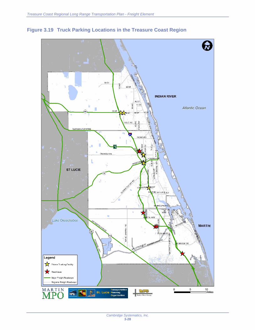
Treasure Coast Regional Long Range Transportation Plan - Freight Element
Cambridge Systematics, Inc. 3-28
Figure 3.19 Truck Parking Locations in the Treasure Coast Region
., ..
FLORIDA'S TURNPIKE
-· L
ST LUCIE
Legend * Private Trucking Facility * RestAreas
-- Major Freight Roadways
MPO 1
95ST
I . , ---
INDIAN RIVER
Atlantic Ocean
10 -----=====Miles 0 5
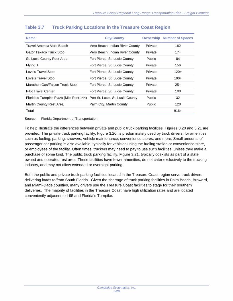
Treasure Coast Regional Long Range Transportation Plan - Freight Element
Cambridge Systematics, Inc. 3-29
Table 3.7 Truck Parking Locations in the Treasure Coast Region
Name City/County Ownership Number of Spaces
Travel America Vero Beach Vero Beach, Indian River County Private 162
Gator Texaco Truck Stop Vero Beach, Indian River County Private 17+
St. Lucie County Rest Area Fort Pierce, St. Lucie County Public 84
Flying J Fort Pierce, St. Lucie County Private 156
Love’s Travel Stop Fort Pierce, St. Lucie County Private 120+
Love’s Travel Stop Fort Pierce, St. Lucie County Private 100+
Marathon Gas/Falcon Truck Stop Fort Pierce, St. Lucie County Private 25+
Pilot Travel Center Fort Pierce, St. Lucie County Private 100
Florida’s Turnpike Plaza (Mile Post 144) Port St. Lucie, St. Lucie County Public 32
Martin County Rest Area Palm City, Martin County Public 120
Total 916+
Source: Florida Department of Transportation.
To help illustrate the differences between private and public truck parking facilities, Figures 3.20 and 3.21 are provided. The private truck parking facility, Figure 3.20, is predominately used by truck drivers, for amenities such as fueling, parking, showers, vehicle maintenance, convenience stores, and more. Small amounts of passenger car parking is also available, typically for vehicles using the fueling station or convenience store, or employees of the facility. Often times, truckers may need to pay to use such facilities, unless they make a purchase of some kind. The public truck parking facility, Figure 3.21, typically coexists as part of a state owned and operated rest area. These facilities have fewer amenities, do not cater exclusively to the trucking industry, and may not allow extended or overnight parking.
Both the public and private truck parking facilities located in the Treasure Coast region serve truck drivers delivering loads to/from South Florida. Given the shortage of truck parking facilities in Palm Beach, Broward, and Miami-Dade counties, many drivers use the Treasure Coast facilities to stage for their southern deliveries. The majority of facilities in the Treasure Coast have high utilization rates and are located conveniently adjacent to I-95 and Florida’s Turnpike.

Treasure Coast Regional Long Range Transportation Plan - Freight Element
Cambridge Systematics, Inc. 3-30
Figure 3.20 Private Truck Parking Facility Example
Source: Google Earth.
Figure 3.21 Public Truck Parking Facility Example
Source: Google Earth.

Treasure Coast Regional Long Range Transportation Plan - Freight Element
Cambridge Systematics, Inc. 3-31
3.5.4 Pipeline Developments
Another mode which is less visible to users is the pipeline network. Florida is significantly dependent upon the natural gas supply as it generates roughly 68 percent of the electricity used by Floridians. In contrast to other states such as Texas, Florida does not produce much of its own natural gas and has no natural gas storage. Central and South Florida depend on two natural gas pipelines operated by Gulfstream Natural Gas System and Florida Gas Transmission. These two pipelines are nearly at capacity as they work to deliver up to 4.4 billion cubic feet of natural gas each day. To expand capacity, Florida Power and Light (FPL) is working with Sabal Trail Transmission, LLC and Florida Southeast Connection, LLC to develop a new pipeline system to better serve Florida’s natural gas needs.
In regards to the Treasure Coast Region, these developments are of local importance. The Florida Southeast Connection pipeline, at a cost of $550 million, will interconnect with the two existing interstate pipelines as well as the new interstate pipeline under development by Sabal Trail Transmission. Construction began in August 2016 on this pipeline which will terminate at the Martin Next Generation Clean Energy Center after passing through Osceola, Polk, Okeechobee, and St. Lucie counties. The completed pipeline will consist of 77 miles of 36” pipe and 50 miles of 30” pipe, which is shown in Figure 3.22. This pipeline was designed to eliminate or minimize impacts to the local ecosystems as it will be constructed adjacent to existing utilities and/or transportation infrastructure. After its expected completion in 2017 this pipeline is projected to deliver about 600 million cubic feet of natural gas per day by 2020.
Figure 3.22 New Interstate Pipeline
Source: NextEra Energy.
/ u:i Midcontinent ,. ......... t ,~ Cf) Expres, ,... \ l- .......... ~ ...... .,
...... ALABAMA ;-...... "-,, ...... ,,.,._
~ ~
Sabal Trail TRANSMISSION
GEORGIA ...... I ·--~ .... .... ~, Florida Gas
Transmission \ ~~ .. ,.
~ ... " I ...
\
Southern Natural Gas
~Company
.. ,.,.\ ....
.. ,. Sabal Trail
Gulfstream
100 miles
\,. , Central ";i Florida
~ Hub '-, .. " .. ,
\

Treasure Coast Regional Long Range Transportation Plan - Freight Element
Cambridge Systematics, Inc. 4-1
4.0 Freight Needs and Priorities
A key component of this Freight Element is the identification and prioritization of freight needs to ensure these established priorities can be reflected in the RLRTP. This section presents an analysis of identified freight needs for highways and non-highway modes.
4.1 Freight Roadway Needs and Priorities
The freight roadway needs and priorities for the Treasure Coast region represent those projects that fall on the defined and adopted regionally significant roadways and address the established ranking criteria. The prioritization score has been factored into the larger RLRTP prioritization process. This section defines the process undertaken to determine the freight roadway priorities.
4.1.1 Regional Freight Roadway Network
The regional freight roadway network, for purposes of identifying roadway needs, was defined as the regional transportation network defined and adopted by the three M/TPOs as part of the RLRTP. This regional network consists of the following three components:
Strategic Intermodal System (SIS) Network;
Treasure Coast RLRTP Primary Regional Facilities; and
Treasure Coast RLRTP Secondary Regional Facilities.
SIS facilities, as mentioned in Section 2, are Florida’s high priority transportation facilities deemed most important to the state’s economy and mobility. SIS roadway facilities in the Treasure Coast region include I-95, Florida’s Turnpike, US 98/441, SR 60 west of I-95, and SR 70 west of I-95 (Emerging SIS). To supplement the SIS network on a more regional level, the Treasure Coast Transportation Council (TCTC) designated a regional roadway network to ensure mobility in the Treasure Coast region. The regional network was first established as a component of the 2030 RLRTP. The 2040 RLRTP updated the regional roadway network to include updates to the network. The Treasure Coast RLRTP network is organized into Primary and Secondary Regional Facilities.
Primary Regional Facilities
All SIS and Emerging SIS facilities are regionally significant and are designated as Primary Regional Facilities. In addition, all principal arterial facilities that meet at least one of the following criteria, and any minor arterial or major collector facilities that meet at least four of the following criteria, are designated as Primary Regional Facilities.
Multi-County – Facilities that traverse more than one county.
SIS Connectivity – Facilities that connect a SIS highway to another SIS Highway.
SIS Intermodal – Hubs, corridors, and connectors identified as SIS and emerging SIS.
Treasure Coast Regional Long Range Transportation Plan - Freight Element
Cambridge Systematics, Inc. 4-2
Freight and Passenger Hubs – Freight and passenger hubs not on the SIS such as airports, bus terminals, ports, or rail yards that function as intermodal hubs.
Intermodal Connectivity – Facilities that serve non-SIS freight and passenger intermodal hubs.
SIS Access – Facilities that connect a SIS highway to another arterial or major collector.
Evacuation Route – Facilities that are designated hurricane evacuation routes, per local comprehensive plans.
Regional Employment Access – Facilities that connect to a regional employment hub (defined as a transportation analysis zone (TAZ) where the employment is two percent or greater of the region’s employment or where the industrial employment is two percent or greater of the region’s industrial employment).
Regional Connectivity – Facilities that connect with the SIS or Emerging SIS or serve another regional facility such as a regional park, sports complex, beach, university, or intermodal hub.
Secondary Regional Facilities
Secondary regional facilities include all intermodal facilities, arterials, and major collectors that are not principal arterials and meet one or more of the primary regional facility criteria listed above.
4.1.2 Roadway Needs
Identification and prioritization of roadway freight needs is a key component of the Treasure Coast Regional Freight Element. Needs have been identified for the roadway mode of freight transportation based on individual M/TPO needs plans developed as part of the 2040 LRTPs. The freight needs identified and prioritized as part of this effort have not been constrained to “cost feasible” projects; they reflect all regional freight needs of the 2040 planning horizon.
4.1.3 Freight Prioritization
Once freight needs were identified, it was necessary to prioritize them to ensure that limited resources are invested in the projects that provide the greatest public benefit. Current prioritization practices by each M/TPO were reviewed to help ensure consistency and compatibility, as appropriate. Each of the regional roadway needs has been evaluated based on a score out of 100 from the Freight Prioritization Worksheet. The data for freight prioritization was gathered using a variety of sources including the 2015 FDOT Florida Transportation Information (FTI) database, the 2014 InfoUSA establishment database, and a comparison of multimodal information. The InfoUSA database is a national dataset that maintains information on business establishments and can be used to identify businesses that are involved in the freight industry. These data were combined to complete the Freight Prioritization Worksheets. The Freight Prioritization Worksheet uses five criteria to apply a point value for each of the regional roadway projects. A high level explanation of these criteria is provided below with Appendix B providing more detailed information regarding criteria and scoring.

Treasure Coast Regional Long Range Transportation Plan - Freight Element
Cambridge Systematics, Inc. 4-3
Fifty-three projects were identified and prioritized. The top 10 projects are listed below in Table 4.1. Appendix C provides the scores for all 53 projects.
Table 4.1 Top 10 Roadway Projects
County Roadway Limits Description Score Rank
St. Lucie Jenkins Road Midway Road to St. Lucie Boulevard
Widen 2 to 4L 80 1
St. Lucie US 1 Martin County to Indian River County
Corridor Retrofit 74 2
Martin I-95 S of Bridge Road to S of High Meadows Avenue
Widen 6 to 8L 66 3
Martin I-95 S of High Meadows Avenue to St. Lucie County
Widen 6 to 8L 64 4
Martin US 1 Cove Road to St. Lucie County Corridor Retrofit 64 4
St. Lucie Glades Cut Off Road
Commerce Center Drive to Selvitz Road
Widen 2 to 4L 63 6
St. Lucie I-95 Northern Connector New Interchange 63 6
St. Lucie Midway road Glades Cut Off Road to Selvitz Road
Widen 2 to 4L 63 6
St. Lucie Florida’s Turnpike Midway Road New Interchange 62 9
St. Lucie Florida’s Turnpike Becker Road to Port St. Lucie Boulevard
Widen 4 to 6L 61 10
Source: Kimley-Horn and Associates, Inc.
Roadway Freight Prioritization Criteria
Truck Traffic (40 points)
− Points are assigned based on the percentage of truck traffic and the total truck AADT for each regional need.
Number of Truck Activity Centers within 0.5 miles from the roadways (25 points)
− Number of Truck Activity Centers within 0.5 miles from the roadways. Points are assigned based on the total number of Transportation, Manufacturing, and Retail/Restaurant businesses within the 0.5-mile radius of the roadway.
The Type of Project (15 points)
− Points are assigned based on a list of projects ranging from Infrastructure Operations/Technology, and Regulatory/Institutional/Other.
Facility Type (10 points)
− Points are based on the classification of the roadway ranging from SIS Corridor to Other Minor Arterial.
Intermodal Connectivity (10 points)
− Points are assigned to those roadways which will provide connectivity to multimodal routes should as transit or trails.
Source: Kimley-Horn and Associates, Inc.

Treasure Coast Regional Long Range Transportation Plan - Freight Element
Cambridge Systematics, Inc. 4-4
4.1.4 Integration with the Treasure Coast Regional LRTP
In addition to the Treasure Coast Regional Freight Element, the overall 2040 Treasure Coast RLRTP has developed a project prioritization process to focus on overall regional transportation needs. The score from the regional roadway freight analysis for each project was incorporated directly into the prioritization criteria for the 2040 RLRTP as one of ten equally-weighted criteria; therefore, freight transportation represents 10 percent of the overall project prioritization in the 2040 Treasure Coast RLRTP.
4.2 Non-Roadway Needs
Non-roadway freight needs include projects that have been identified for the airports, seaport, and railroads. The list of needs is driven by available project lists identified by the facilities through master plans, capital improvement plans, as well as projects included in FDOT’s work program. Without an active outreach program, and given the limited list of freight needs, it was determined no prioritization would be completed for these projects.
4.2.1 Railroad Needs
The railroad infrastructure in the Treasure Coast region is privately owned and operated. At present, no freight project needs have been identified for FEC, CSXT or SCFX for infrastructure located in the region. Efforts by All Aboard Florida to add capacity to the FEC corridor are underway and have not been included in this analysis.
4.2.2 Seaport and Waterway Needs
The region is home to the Port of Fort Pierce. With excellent direct access to the FEC and acres of undeveloped land, the port is looking for new business opportunities and new tenants that may have overlooked this undeveloped port. The County has moved forward with a list of funded and unfunded projects designed to ensure its viability into the future. Table 4.2 summarizes funded seaport projects. These include roadway access improvements, property acquisition, and bulkhead and dredging improvements. Table 4.3 summarizes unfunded seaport projects. The unfunded project list provides short, mid and long term projects focused on roadway improvements (access and internal), bulkhead and dredging improvements, re-establishment of rail connections, and more distant connections to hubs like the Treasure Coast International Airport.
Table 4.2 Funded Seaport Projects
Description FDOT Funding Status
New Port Entrance (Design and Construction) $4,242,500 Anticipated Construction Completion: April 2018
Fisherman’s Wharf Road Redevelopment $125,000 Anticipated Design Completion: May 2017
Fisherman’s Wharf Property Acquisition $255,000 Letters of interest sent to property owner
Fisherman’s Wharf Bulkhead & Dredging $225,000 New JPA for 17/18
Seagrass Study & Concept Development Plan $125,000 New JPA for 17/18
Source: Florida Department of Transportation.

Treasure Coast Regional Long Range Transportation Plan - Freight Element
Cambridge Systematics, Inc. 4-5
Table 4.3 Unfunded Seaport Projects
Description Horizon Improvement Type Project
Cost
Construct Fisherman’s Wharf Roadway Short-Term Highway Connectors Capacity Project $800,000
Construct Bulkhead and Dredging at Fisherman’s Wharf
Short-Term Waterway Connectors Capacity Project $3,500,000
Construct Terminal Drive Roadway Short-Term Highway Connectors Capacity Project $1,500,000
Construct Harbor Street Roadway Short-Term Highway Connectors Capacity Project $2,500,000
Construct Port Avenue Roadway Short-Term Highway Connectors Capacity Project $500,000
Construct Avenue M Street Extension Short-Term Highway Connectors Capacity Project $2,500,000
Construct Bulkhead/Shore Stabilization and Dredging at Harbour Pointe
Short-Term Waterway Connectors Capacity Project $8,000,000
Construct Bulkhead and Dredging at Destin Beach, Inc.
Mid-Term Waterway Connectors Capacity Project $12,000,000
Re-establish Indian River Terminal Railway Spur Mid-Term Railroad Connectors Capacity Project $5,000,000
Re-establish Avenue M Railway Spur Mid-Term Railroad Connectors Capacity Project $5,000,000
Re-establish Fisherman’s Wharf Railway Spur Mid-Term Railroad Connectors Capacity Project $5,000,000
Establish Treasure Coast International Airport Highway Connector to the Port
Long-Term Highway Connector Capacity Project $14,000,000
Establish Treasure Coast International Airport Railway Connector to the Port
Long-Term Railroad Connectors Capacity Project $15,000,000
Establish Regional Distribution Center Railway Connector to the Port
Long-Term Highway Connector Capacity Project $65,000,000
Source: Florida Department of Transportation.
In addition to the port, the region also has an extensive waterway system. The 2014 Martin and St. Lucie Regional Waterways Plan was reviewed to identify projects. While a comprehensive set of recommendations was provided, there were no specific projects defined. Recommendations related to freight focused on developing a strategy for the Port of Fort Pierce, maintenance dredging, protecting access to marine industrial areas, assessing the impacts of All Aboard Florida, and more.
4.2.3 Airport Needs
As described above, the airports in the Treasure Coast region do not serve large amounts of cargo. As such, the airport projects identified for the Treasure Coast region tend to benefit overall airport operations, not just freight movements. Table 4.4 illustrates ongoing and programmed FDOT investments in the region’s airports. Over $50 million has been invested by the FDOT from 2011 to 2016 with over $40 million more programmed for 2017 to 2022. Key capacity related projects have been called out. The majority of these funds (72 percent) have been dedicated to the Treasure Coast International Airport and the Vero Beach Regional Airport. The airports continue to strive for improvement, as demonstrated by the multi-million dollar projects programmed for each facility. Note the funding and projects listed reflect state allocations; other funds may also be allocated towards these airports by non-FDOT sources.

Treasure Coast Regional Long Range Transportation Plan - Freight Element
Cambridge Systematics, Inc. 4-6
Table 4.4 Airport Improvements Identified in FDOT Work Program
Airport 2011-2016 2017-2022 Total
Martin Airport $1,625,965 $0 $1,625,965
Sebastian Airport $3,765,780 $4,411,648 $8,177,428
Design and Construct Taxiway C, D & E $3,904,648 $3,904,648
Treasure Coast International Airport $16,754,222 $14,338,726 $31,092,948
Airport Expansion (Maintenance and Repair Operations) $5,055,000 $5,055,000
Strengthen Runway 10R/28L $3,679,726 $3,679,726
Airfield Signage & Lighting $1,800,000 $1,800,000
Vero Beach Regional Airport $22,929,888 $13,319,871 $36,249,759
Rehab Runway 12R/30L $4,500,000 $4,500,000
Reconstruct Center Apron $2,000,000 $2,000,000
Rehab, Mark & Light North Apron $1,875,000 $2,000,000
Witham Field $6,413,139 $9,450,555 $15,863,694
Taxiway A Improvements $1,500,000 $1,500,000
Customs Facility $537,262 $1,000,000 $1,537,262
Airport Security Fence $1,000,000 $1,000,000
Total $51,488,994 $41,520,800 $93,009,794
Source: FDOT Work Program.

Treasure Coast Regional Long Range Transportation Plan - Freight Element
Cambridge Systematics, Inc. 5-1
5.0 Summary of Freight System
The Treasure Coast region is home to a multi-modal freight transportation system. Roadways are the foundation, providing truck access to established industries, while other modes provide varying degrees of service. A summary of key characteristics of the freight system are presented below:
Freight considerations have been included in policy language. Each M/TPO has addressed freight in existing goals and objectives to varying degrees. Consistency with MAP-21 was a key consideration. Opportunities for future enhancements exist.
Key regional roadways have been identified. Indian River and St. Lucie counties have designated key truck routes and Martin County has identified key regionally significant roadways. The NHFN and SIS highlight key interregional corridors.
Freight rail service is provided by three railroads. The region is served by FEC, CSXT and SCFX. FEC is the primary provider with direct connections to Port of Fort Pierce and a rail yard in Fort Pierce. All three provide direct carload service to rail served properties.
Port of Fort Pierce has expansion opportunities. The community continues to explore strategic opportunities to make the best use of the facility while preserving the quality of life in adjacent communities.
Waterways handle limited cargo movement. The region is home to the AIW, and the St. Lucie River/Canal. While the waterways are maintained, barge traffic has decreased significantly in recent years due to shifts in industry patterns. Marine industries do rely on the waters. The region also has identified a set of strategies for alternate non-freight use of the waterways.
Limited air cargo services exist but there are opportunities for economic development. The region’s airports provide largely general aviation operations. Commercial service recently returned to Vero Beach Regional Airport. Treasure Coast International Airport is designated as an FTZ and is a US Customs Port of Entry. Master plans for both highlight a desire for expanded industrial development. Other local airports also offer general aviation services and have a significant economic impact on the region. Witham Field, for its part, has been working to acquire a Customs facility in order to increase traffic at this facility.
Freight activity centers are clustered around key corridors. Existing freight intensive businesses are located in close proximity to I-95 and Florida’s Turnpike interchanges, along key commercial corridors, and adjacent to transportation hubs (e.g., airports).
Region is home to significant truck parking facilities. These consist of public and private facilities with a range of amenities. They operate at high levels of occupancy and serve truck drivers serving the South Florida market.
Top roadway priorities for freight focus on capacity expansion along key corridors. Key projects include widening/adding lanes, new interchanges along I-95 and Florida’s Turnpike, and corridor retrofits.


Treasure Coast Regional Long Range Transportation Plan - Freight Element
Cambridge Systematics, Inc. A-1
Appendix A. Existing Freight Plans and Programs
A review of previously completed plans and programs was conducted in order to determine their relevancy in guiding the Treasure Coast Freight Element. A list of reviewed plans and programs is found in Table A.1 along with a brief summary of each.
Table A.1 Existing Freight Plans and Programs
Title Study Level Year Summary
Vero Beach Municipal Airport Master Plan Briefing
Airport 2016
This document serves as a general overview of what the Vero Beach Municipal Master Plan will detail with regard to the airport’s needs and potentials. The document demonstrates that 10 percent of its tenants will need more capacity in order to meet the demand in next five years. Moreover, the areas where the airport can improve its infrastructure are demonstrated. Lastly, the document provides an analysis of the airport’s market share and traffic.
Compilation of Data and Recommendations for Port of Fort Pierce Master Plan Update
Seaport 2013
This document proposes revisions to the 2002 Port of Fort Pierce Master Plan and aims to stimulate economic development and job creation. It also identifies projects that could be submitted for Seaport/Intermodal funding requests to the state. Under the Jobs and Economic Impacts section, the document illustrates the port’s potential in increasing tax revenues and creating highly paid jobs. It also emphasizes the need for improvement and investment in Florida ports due to the Panama Canal construction and the expected increase in the amount of cargo reaching the East Coast.
2011 Master Plan Update St. Lucie County International Airport
Airport 2011
The St. Lucie County International Airport master plan serves as a tool to analyze trends in aviation activity, assess facility needs, and identify needed development projects, thereby providing a vision for future airport development. The document mentions the Florida Strategic Intermodal System (SIS) program as an additional source of funding besides available to airports classified as SIS facilities.
St. Lucie TPO Long Range Transportation Plan (GO 2040)
County 2016
The Go 2040 LRTP is intended to guide the investment in multimodal transportation options and identify projects to be completed over the next 25 years in St. Lucie County. The document discusses the TPO’s goals and objectives for freight, its assessment of County’s freight system including highways, rail, seaports, and air, and the opportunities and emerging issues related to freight including the Northern Connector between Florida’s Turnpike and I-95, and the North St. Lucie County Freight Logistics Zone. A brief illustration of the St. Lucie freight network concludes the section on freight.
Martin MPO 2040 Long Range Transportation Plan (Moving Martin Forward)
County 2015
The 2040 LRTP details how Martin County’s multimodal transportation system will evolve over the next 25 years. The document includes freight movement in its Important Themes (Chapter 4) under the Freight Transportation section. Several freight-related plans and freight modes are listed which the county can benefit from or improve. Specifically, the document talks about truck traffic overview, through freight traffic, the Southeast Florida Regional Freight Plan, railroad traffic increases, agriculture, waterways, and freight traffic forecasts.
Indian River County 2040 Long Range Transportation Plan Update (Connecting IRC)
County 2015
The document mentions freight in its Goal 2, a transportation system that provides travel alternatives which enhance mobility for people and freight. This document focuses on freight movement in the Freight Improvements section. This section demonstrates the county’s truck route roadway improvement projects.
Martin – St. Lucie 2035 Regional Long Range Transportation
Martin County and St. Lucie County
2011 The RLRTP creates a regional strategy for transportation priorities and funding, enhances information sharing between the M/TPOs, and creates a joint decision-making process regarding regional transportation issues. The

Treasure Coast Regional Long Range Transportation Plan - Freight Element
Cambridge Systematics, Inc. A-2
Title Study Level Year SummaryPlan (Enhancing Mobility)
document discusses Regional Freight and Good Movement under Chapter 3, Study Area Data Review and Analysis.
Indian River County 2035 Long Range Transportation Plan Update
County 2010
The LRTP focuses on freight movement in two sections, namely, the Indian River MPO Truck Traffic Routing Plan, and Freight Improvements. The latter demonstrates the county’s truck route roadway improvement projects, while the former explains the basis for directing commercial trucks to their destinations in an effort to minimize the impact on residential neighborhoods.
Strategic Intermodal System (SIS) Policy Plan
Statewide 2016
The Strategic Intermodal System (SIS) is Florida’s high priority network of transportation facilities deemed most important to the state’s economy. This document presents general information about the SIS and provides some SIS example projects. In the document, freight plays a key role in all emphasis areas, namely, interregional connectivity, intermodal connectivity, and economic development. The document also presents freight-related projects as part of SIS example projects which shows the importance of freight to the SIS visions and goals.
Florida Transportation Plan Policy Element
Statewide 2015
The FTP Policy Element is Florida’s long-range transportation plan. This document defines goals and objectives for Florida’s transportation system over the next 25 years. The Policy Element establishes the policy framework for the expenditure of state and federal transportation funds flowing through FDOT’s work program. Freight is specifically mentioned in two of the seven goals that form the long-range vision of FTP Policy Element. These two goals are: “efficient and reliable mobility of people and freight”, and “more transportation choices for people and freight”. Freight-related emphasis areas that will facilitate achieving these goals are: increasing the efficiency, capacity, and last-mile connectivity of Florida’s major air/sea/space ports and other freight terminals, increasing the efficiency, capacity, and connectivity of major truck, rail, and water corridors through targeted capacity improvements, accommodations for heavy freight movement, and separation of freight and passenger traffic on shared corridors.
Florida Statewide Aviation Economic Impact Study
Statewide 2014
This update to the Florida Statewide Aviation Economic Impact Study was completed in 2014 as part of the update to the Florida Aviation System Plan (FASP). This study provides an estimated annual economic impact for 19 commercial service airports, 102 public-use general aviation airports, and 11 military aviation facilities within Florida. This includes direct, indirect, and induced impacts.
Florida Freight Mobility and Trade Plan Investment Element
Statewide 2014
The Investment Element of the FMTP is organized to continue where the FMTP Policy Element concluded, and discusses all of the elements FDOT and its partners used to identify freight related investments needed for Florida’s economy to continue to grow. In Chapter 4, the document explains the freight policies, strategies, and prioritization criteria that will guide the freight‐related transportation investment decisions of the State. Specifically, the project rating criteria has been explained in full content by stating how projects can gain more points based on the defined criteria. Moreover, Chapter 5 presents how freight projects were collected and a summary of Florida Freight Needs, as well as the full project list by priority group.
Florida Freight Mobility and Trade Plan Policy Element
Statewide 2013
The Florida Freight Mobility and Trade Plan (FMTP) provides the State with an integrated and comprehensive plan to focus on objectives and strategies to benefit the movement of goods, commodities, and services. The FMTP focuses on four goals, three of which are directly related to freight. These three goals are: increasing the flow of domestic and international trade through the state’s seaports and airports, increasing the development of intermodal logistic centers (ILC) in the state, and increasing the development of manufacturing industries in the state. In Chapter 4, the FMTP explains how its seven objectives are in line with the 2060 FTP, MAP-21, and state legislation 2012 HB 599. The FMTP goals generally focus on developing trade, increasing the efficiency of goods movement, and minimizing the cost of moving freight. Airports, seaports, ILCs, and freight networks are the core components of the FMTP objectives.

Treasure Coast Regional Long Range Transportation Plan - Freight Element
Cambridge Systematics, Inc. A-3
Title Study Level Year Summary
Fixing America’s Surface Transportation Act (FAST Act)
Federal 2015
This law provides long-term funding for surface transportation, meaning States and local governments can move forward with critical transportation projects with the confidence that they will have a Federal partner in the long term. The FAST Act includes a number of provisions focused on the movement of freight, including: establishing a national multimodal freight policy, new discretionary freight-focused grant program for funding to improve safety, eliminate freight bottlenecks, and improve critical freight movements. It also includes promoting best contracting practices and innovating financing and funding opportunities by reducing uncertainties and delays with respect to environmental reviews and permitting.
Moving Ahead for Progress in the 21st Century Act (MAP-21)
Federal 2012
MAP-21 creates a streamlined, performance-based, and multimodal program to address the many challenges facing the U.S. transportation system. One of the focal points of MAP-21 is freight movement. Under Section 1115, it is mentioned that the policy of the U.S. is to improve the condition and performance of the national freight network. The following are included in the goals of the national freight policy: to invest in infrastructure improvements, to improve the safety, security, and resilience of freight transportation, and to improve the state of good repair. Under Section 1116, the document demonstrates prioritization of projects to improve freight movement. Projects that demonstrate improvement in freight movement, and are identified in a state freight plan, will be eligible for increased funding under this section.
Source: Cambridge Systematics.


Treasure Coast Regional Long Range Transportation Plan - Freight Element
Cambridge Systematics, Inc. B-1
Appendix B. Prioritization Process


Treasure Coast Regional Long Range Transportation Plan - Freight Element
Cambridge Systematics, Inc. C-1
Appendix C. Scoring Worksheet