Embed Size (px)
Citation preview

A. Kö et al. (Eds.): EGOVIS/EDEM 2013, LNCS 8061, pp. 196–210, 2013. © Springer-Verlag Berlin Heidelberg 2013
Towards a Linked Geospatial Data Infrastructure
Sonya Abbas and Adegboyega Ojo
Digital Enterprise Research Institute, National University of Ireland, Galway, Ireland
{sonya.abbas,adegboyega.ojo}@deri.org
Abstract. The pressure of opening access to public sector geospatial information traditionally managed within disparate spatial data infrastructures (SDI) is driven by a combination of factors. These factors include the adoption of open data programs and the need to integrate spatial data across sectors and levels of government for specific applications. Informed by the success of the Linked Open Data community, efforts to leverage Linked Data in enabling global access to spatial data currently managed within national and regional SDIs are emerging. However, these early efforts do not provide guidelines for implementing such Linked SDI nor articulate the socio-technical requirements for a successful Linked Geospatial Data strategy. By analyzing existing SDI architectures and emerging Linked SDI requirements, we develop Reference Architecture for building interoperable Linked SDIs.
Keywords: Linked Geospatial Data, Spatial Data Infrastructure (SDI), INSPIRE, e-Government Infostructure.
1 Introduction
Geospatial or geographic data describing information tied to some locations on Earth’s surface [1], constitute an important and rapidly growing category of government data assets. This category of data are considered critical for planning, policy making and delivering innovative location based services in domains including disaster mitigation, public health, geology, civil protection and agriculture [2].
An important aspect of managing geospatial data is the provisioning of the so-called Spatial Data Infrastructure (SDI); an information infrastructure providing access and enabling interoperability among spatial information based on standards, policies, regulations and coordination mechanisms [3][4]. As at 2009, over 120 countries have developed one form of National SDI or another [4]. With increasing information integration efforts at regional and global levels and wide spread adoption of Open Government and data programs by governments in Europe and other parts of the world, there are compelling arguments for revisiting the notion of “Global SDI” (GSDI). GSDI encompasses the policies, technologies, standards and human resources necessary for the effective collection, management, access, delivery and utilization of geospatial data in a global community [5]. According to [6], a GSDI is expected to integrate information from regional SDIs to provide so-called global datasets with global spatial coverage.

Towards a Linked Geospatial Data Infrastructure 197
While efforts by organizations like Open Geospatial Consortium (OGC) [7] and the United Nations Geospatial Information Working Group (UNGIWG) [8] in producing standards and reference models have significantly advanced the interoperability and exchange of geospatial information, the goal of realizing a global SDI is far from realized. Specifically, no single or distributed repository of geospatial data with global spatial coverage based on OGC standards and reference framework is available.
Although not strictly a GSDI, the INSPIRE (Infrastructure for Spatial Information in the European Community) SDI [9] which employs OGC standards like the Geography Markup Language (GML); presents an innovative approach to integrating National SDIs in a specific region based on a legally enforceable instrument. The SDI defines several spatial data themes and services; metadata standard, network services and technology specifications, agreement on sharing and access, coordination and monitoring mechanisms as well as processes and procedures. Unfortunately, the use of legally enforceable instrument as way to mandate the adoption of standards is not feasible at a global level.
Interestingly, the Linked Data community has arguably built a truly global space of data maintained by a dedicated community of researchers and practitioners based on standards and best practices provided by the World Wide Web Consortium (W3C) [10]. This success could be attributed to the simple representation format of the data - Resource Description Framework (RDF), its widespread adoption, and the strong global influence of the W3C consortium. Not surprisingly, the concept of Linked Geospatial (or Geospatial Linked) Data, i.e. geospatial data stored in RDF, created, managed and accessible based on the Linked Data principles and standards has appeared in the last few years [11][12]. Most of Linked geospatial studies have so far aimed at providing an alternative representation format and access method to geospatial data maintained within SDIs. For example, the Linked Geodata platform [13][11].
However, current studies on Linked geospatial data are fragmented and do not provide concrete guidelines for implementing a Linked SDI nor do they provide the policy, standards and community imperatives for a successful Linked geospatial data strategy. Our goal in this work is two folds: 1) to integrate and organize existing work on Linked geospatial data and Linked SDI into a reference model for government and 2) to highlight the policy, standards and organizational requirements for Linked SDI. For illustration, the paper also shows how Linked Data could be employed in the context of the INSPIRE SDI.
The rest of the paper is organized as follows: Section 2 presents the background on SDI and Linked Data. Our approach for developing the Linked SDI reference model is presented in Section 3. The synthesized SDI reference model is presented in Section 4 and refined for Linked Data enabled implementation in Section 5. Validation of the LSDI reference model is presented in Section 6 and discussed in Section 7. Finally, some concluding remarks are presented in Section 8.

198 S. Abbas and A. Ojo
2 Background
This section provides conceptual underpinnings and characteristics of SDIs and highlights how Linked Data concept provides a complementary semantic information integration approach for implementing SDIs and global SDIs.
2.1 Spatial Data Infrastructure
SDI is a multi-disciplinary concept that includes people, data, access networks, institutional policies, technical standards and human resources [14]. According [6], the notion of SDIs is continually evolving and also an inherently hierarchical, where one SDI is related to another belonging to different jurisdictional levels, typically global, regional, national, local and corporate levels.
As a platform, SDIs link data users to providers on the basis of the common goal of data sharing. Regardless of the jurisdiction of SDIs, they enhance the capability of governments to engage in systems-based, integrated and holistic decision making about the future of that jurisdiction [14]. They operate subject to policies that govern access, use, pricing of services, sustained financing, quality management and human resources development [15].
A number of features are commonly associated with SDIs [14]: 1) they enable communication and sharing of information, 2) they are networked infrastructures that allows all user benefits when a user joins the network, 3) they encompass both technical and social elements and therefore are socio-technical systems, 4) they support wide array of stakeholders in the communication and sharing of spatial data, 5) they operate within unstable environments and so need to adaptive, 6) they develop institutionalized properties in their ability to communicate, connect and share between stakeholders.
These functionalities are realized through a number of core components. Table 1 identifies the typical elements of SDIs as described in literature: [1], [3], [4], [6], [9], [16] and [17]. Consistent with the description of SDI above, elements of an SDI are essentially of the following types: Policy, Standards, Data, Network Access and People.
Efforts to integrate geospatial information across SDIs rely on the use of set of standards and institutional agreements such as those of OGC and UNGIWG. Given that effectiveness of standards is linked to the degree of its adoption, standards by global an influential entities such as W3C are relatively more likely to succeed. In addition, meaningful spatial information integration requires adopting of shared vocabularies by geospatial data providers or SDIs. The Linked Data approach presented in the next section is recognized as a global standard for publishing semantically-rich open (or enterprise) data.

Towards a Linked Geospatial Data Infrastructure 199
Table 1. Elements of Spatial Data Infrastructures
No. Source SDI Elements 1 [9] Data, Network, Policy, Standards, and People 2 [3]
Applications, Network, Policy, Data (foundation, framework, application-specific), Metadata and Partnership
3 [6] Policy, Fundamental Datasets, Technical standards, Access Network and People
4 [4] Legislative Framework, Content and Data Framework and Metadata and Standard, Quality Issues, Geo-portals and Distributed Information Systems, Architecture, Human Factors, Dissemination and Implementation
5 [1] Communities, Roles (user, contributor, custodian, governing body, operational body, contact, educator, promoter, funder, member, communication channel, SDI catalog), Spatial asset (core asset, spatial asset metadata), Enterprise objects (person, team, organization, spatial dataset, spatial application, spatial service, geo-portal), Policies (governance, role assignment, infrastructure, standards, quality, promotion, education, funding, access, membership), Interactions and Objectives
6 [17] Services (web service, SDI service, processing service –transformation service-, information management service-portrayal service, access service, catalog service, gazetteer service, knowledge model service-, application service) SDI client (application, geo-portal) Repository (metadata, knowledge model, dataset –spatial-)
7 [16] Clients (user applications), Middleware (geo-processing, catalogue services, catalogues), Content repository (geospatial data, other data)
2.2 Linked Data and Spatial Data Infrastructure
Linked Data refers to a set of good practices for publishing and connecting structured data on the web [10]. Technically, Linked Data is a machine-readable data that is linked to external data sets on the rapidly expanding Web of Data Cloud. The goal of Linked Data according to Berners-Lee is to create a single global data space on the web. The notion of Linked Data is underpinned by four core principles [10]: 1) use of URIs (Uniform Resource Identifier) as names for things, 2) use of HTTP URIs so that people can look up those names, 3) URI should return useful information when looked up by utilizing standards such as RDF and SPARQL and 4) include links to URIs, so they can discover more things.
In recent years, studies on the adoption of Linked Data and Semantic Web in developing SDI have grown [18]. The W3C Incubator Group for example, provides many annotation methods and defines XLINK as a language for adding hyperlinks to XML and RDFa to enrich metadata for OGC standards like GML [19]. Works such as [19] and [20] have also shown how OGC services and semantic technologies can be

200 S. Abbas and A. Ojo
integrated. Specifically, [20] highlights how Linked Data can be used within an SDI and compares RDF with GML. In [21], the treatment of Geo-Linked Data includes proxies which incorporate references to Geoweb and services in Semantic Web. In their work, URI describes a real world resource and the user can access either RDF or HTML through Geo Linked Data server or a GML representation in a Geoweb service.
Other works in this domain seek to refine Linked Data principles to meet geospatial community requirements. They address more specific issue related to Linked Data such as URI design, data models for representing and querying spatial data on the Semantic Web. For instance, the United Kingdom Government through its CTO council has developed best practices and guidelines for designing URIs for geospatial data [22]. In [23], proposal for refining existing W3C data models to meet the representational and querying needs of spatial data in the Semantic Web was presented using stRDF and stSPARQL standards. stRDF is an extension of RDF that allows for the representation of temporal geospatial data while stSPARQL adds filters to SPARQL queries to enable the discovery of topological relations between geometries.
Research on linking URIs is fundamental in enabling integration of data into the web of data cloud. Different approaches have been proposed for linking. Authors of [24] encode hierarchical topological relations between geographic entities over traditional spatial queries to link Great Britain datasets even in the absence of explicit geometric information. Other researches focus on the ontologies linking level to discover semantic relationships [25][26]. In [27], issues arising when interlinking the LoD cloud was addressed. They propose the use of upper level ontologies and schema level links to address these issues. They also commented on the misuse of the “owl:sameAs” in the LoD cloud. Authors of [24] support this argument by clarifying that “owl:sameAs” relation is over-used for linking entities which leads to mismatching problems. Instead they propose using alternative relationships such as “rdfs:seeAlso” and “coref:duplicate” to find related URIs no matter the nature of the relationship.
3 Approach
The objectives of our study includes: 1) providing a reference architecture for a Linked Data enabled Spatial Data Infrastructure, 2) showing how the reference architecture could be employed in analyzing the requirements a Linked Data strategy, using the INSPIRE initiative as example. Our SDI reference model aims to capture the major elements of existing SDIs as described in different scholarly works and international standards such as those related to The Open Geospatial Consortium [7]. The reference model will also consider future SDI needs.
The Linked SDI reference model is developed in two major steps in line with approach for developing reference architectures [28]: 1) Construction of a base reference architecture for traditional SDIs, 2) Refinement of the base reference architecture based on the Linked Data principles and existing work on Linked SDI to produce a Linked SDI reference architecture. These steps are explained below:

Step 1 - Constructing the SDConstructing the SDI-BRAscholarly publications descthe definition, form or natidentifying the core dimensdimension, 4) integrating thand 5) validating the SDI-B
Step 2 - Refining SDI-BRA The refinement of the SDIanalyzing and consolidatinarticulating requirements fo#1 as the architectural visibased on the architectural v
Finally, we highlight thecritical actions for moving t
Fig. 1. App
4 Reference Mode
In this section, we developrelated work, partly presendatabase-oriented infrastrucprocess-oriented and empha
To obtain the overall strcontent analysis on the vashowed that the five classicStandards and Policy; wedimensions are elaborated b
Towards a Linked Geospatial Data Infrastructure
DI Base Reference Architecture (SDI-BRA): A consists of the following five activities: 1) identifycribing specific SDIs, 2) carrying out content analysesture and elements of SDIs described in these papers,sions of the SDI-BRA and core elements constituting ehe dimensions and their elements to produce the SDI BRBRA with respect to existing SDI architectures.
to Linked SDI Reference Architecture (LSDI-RA): I-BRA is done through three major activities includingng information in literature on SDI and Linked Data,or a Linked Data SDI from information obtained in activon, and 3) extending the SDI-BRA developed in Step
vision to obtain the reference architecture for Linked SDe use of the Linked SDI-RA in identifying and prescribtowards a Linked Data enabled INSPIRE SDI.
proach for Linked SDI Reference Architecture
el for Spatial Data Infrastructure
p the base reference model based on our review of Snted in Section 2. SDIs have evolved from product ctures to a new generation of infostructures that are masize partnerships and stakeholders involvement [9]. ructure or core dimensions of our SDI-BRA, we carry arious aspects of SDI described in Table 1. Our analyc dimensions of SDI which include Data, Network, Peopere structurally adequate to describe SDIs. These fbelow.
201
ying s of , 3)
each RA,
g 1) , 2) vity
p #1 I.
bing
SDI and
more
out ysis ple, five

202 S. Abbas and A. Ojo
Data Dimension describAt least five kinds of data aprovide thematic informahydrography [3], 2) foundageodetic control, basic topodatasets [3], 4) knowledgequality and ownership of dfacilitate the process of dconditions of use [3].
Network Access Dimensthree kinds of services aprocessing and transformaservices cover geo-servicesan SDI [17]. Informationvisualization of spatial dservices to link toponyms geo portals and applications
Fig
People Dimension incluinformation interacting witSDI [6] such as organizatio
Infrastructure Standardwhich provides technical gdata providers and commdimension enables interope
o
bes the typical categories of datasets maintained by SDare identified by SDIs including: 1) framework datasets tation in a national context such as land cover ation datasets that covers geospatial aspect of SDI suchography and geo names datasets [3], 3) application-spece model that defines knowledge about the type, locatidatasets [5], and finally the 5) catalogue of meta data
discovery of the available data through the SDI and
sion consists of services and clients applications. At leare provided by SDIs including generic SDI servication services to information management services. Ss, geographic information services and all web servicen management services include portrayal services atasets, access services for downloading, and gazeand their spatial locations [17]. SDIs should also provs as clients to allow geographic information access.
g. 2. SDI Base Reference Architecture
udes all stakeholders, both users and producers of spath the SDI to drive the development and utilization of ns, roles, partnerships and communities.
ds Dimension constitutes an important SDI componguidance and enforceable rules to be followed by spa
munities in the development and use of SDIs [9]. Tration across SDI hierarchies.
DIs. that and h as cific ion, a to the
east ces, SDI s in for
etter vide
atial the
nent atial The
Towards a Linked Geospatial Data Infrastructure 203
Policy Dimension specifies important decisions on core aspects of the SDI including governance, role assignment to memberships, quality and funding. Two categories of policies have been defined which are legislation/senior policy and regulation/local policy. Relationships between these two classes of policies are elaborated in [3].
We present in Fig.2 the five dimensions and their core dimensions in Fig.1. We present in Section 5 how this reference model could be refined to support Linked Data enabled SDI development.
5 Blueprint for Linked Geospatial Data Infrastructure
This section describes the core elements of a Linked SDI Reference Architecture (LSDI-RA). We understand a Linked Data enabled SDI or simply Linked SDI as an information infrastructure with traditional SDI capabilities and that is in addition capable leveraging Linked Data principles in the management and integration of its datasets by utilizing Semantic Web technologies. We consider an LSDI or indeed any SDI as a socio-technical system and thus organize the description of its elements into two categories: 1) the technical elements comprising the data and network access components described in Section 5.1 and 2) the socio-organizational components consisting of the enabling and constraining policy, standards as well as people and community responsible for creating, using and evolving the technical components of the SDI, described in Section 5.2. Fig.3. presents a summary of the Linked SDI Reference Architecture discussed in Sections 5.1 and 5.2.
5.1 Technical Components
We identify here the major elements of the Data and Networked Access dimensions of our LSDI reference model by refining the elements of the BRA in Section 4 with the emergent semantic requirements obtained from the existing work on Linked Data and SDIs.
Data – The data dimension of LSDI consists of the three categories of datasets, a knowledge model, and catalog as described in the SDI-BRA. The Foundation dataset in LSDI includes resources describing places or locations in RDF format [18] such as Geonames [10]. The representation and management of foundational data in Linked SDI is based on the Linked Data principles. For instance, places or locations described in the foundational datasets are expected to have URI with links pointing to other related places based on one or more geospatial relations [29]. In addition, Linked SDIs are also expected to manage thematic Geospatial data (or Framework datasets), such as Earth Observation [18], Land Cover [7], Topography [19] and Administrative Hierarchy [30] datasets as Linked Data. Likewise, application-specific datasets such as DBpedia dataset [18], Linked Geodata [31] and Geoweb [9] are also maintained as Linked Data on the Linked SDI. Ontologies [19], [32], [9] and ontology mapping resources [5] underpinning RDF-based datasets are maintained as part of the knowledge model in Linked SDI. User-generated contents from the social processes
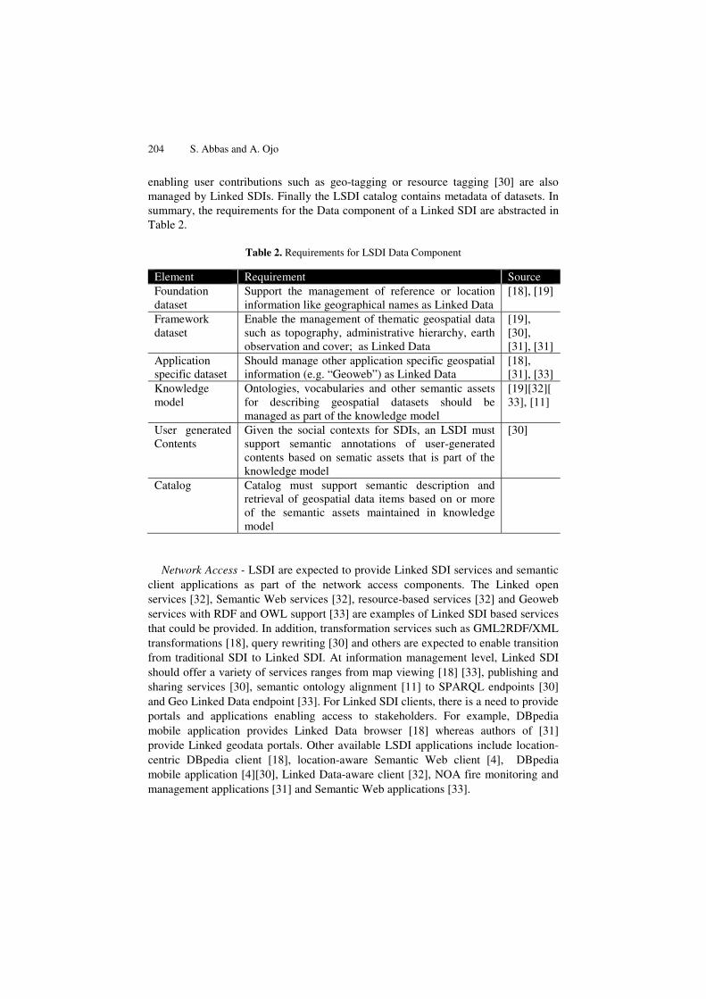
204 S. Abbas and A. Ojo
enabling user contributions such as geo-tagging or resource tagging [30] are also managed by Linked SDIs. Finally the LSDI catalog contains metadata of datasets. In summary, the requirements for the Data component of a Linked SDI are abstracted in Table 2.
Table 2. Requirements for LSDI Data Component
Element Requirement Source Foundation dataset
Support the management of reference or location information like geographical names as Linked Data
[18], [19]
Framework dataset
Enable the management of thematic geospatial data such as topography, administrative hierarchy, earth observation and cover; as Linked Data
[19], [30], [31], [31]
Application specific dataset
Should manage other application specific geospatial information (e.g. “Geoweb”) as Linked Data
[18], [31], [33]
Knowledge model
Ontologies, vocabularies and other semantic assets for describing geospatial datasets should be managed as part of the knowledge model
[19][32][33], [11]
User generated Contents
Given the social contexts for SDIs, an LSDI must support semantic annotations of user-generated contents based on sematic assets that is part of the knowledge model
[30]
Catalog Catalog must support semantic description and retrieval of geospatial data items based on or more of the semantic assets maintained in knowledge model
Network Access - LSDI are expected to provide Linked SDI services and semantic
client applications as part of the network access components. The Linked open services [32], Semantic Web services [32], resource-based services [32] and Geoweb services with RDF and OWL support [33] are examples of Linked SDI based services that could be provided. In addition, transformation services such as GML2RDF/XML transformations [18], query rewriting [30] and others are expected to enable transition from traditional SDI to Linked SDI. At information management level, Linked SDI should offer a variety of services ranges from map viewing [18] [33], publishing and sharing services [30], semantic ontology alignment [11] to SPARQL endpoints [30] and Geo Linked Data endpoint [33]. For Linked SDI clients, there is a need to provide portals and applications enabling access to stakeholders. For example, DBpedia mobile application provides Linked Data browser [18] whereas authors of [31] provide Linked geodata portals. Other available LSDI applications include location-centric DBpedia client [18], location-aware Semantic Web client [4], DBpedia mobile application [4][30], Linked Data-aware client [32], NOA fire monitoring and management applications [31] and Semantic Web applications [33].

Towards a Linked Geospatial Data Infrastructure 205
Table 3. LSDI Network Access Component
Element Requirement Source SDI services Support RDF and OWL based Semantic Web
services, resource based services and Geoweb services that interacts with the other components
[18], [9]
Processing Services
Transformation tools from traditional SDI languages to the new Linked SDI languages (e.g. GML2RDF/XML) should be covered by the processing services
[19], [30]
Information management Services
Support the management of Linked SDI by providing publishing and sharing services, web mapping services and geo Linked Data endpoint (SPARQL) that enable semantic geospatial data searching
[18],[30], [33]
SDI clients Support semantic and Linked Data based query and retrieval of geospatial information
Geo-portals There is a need to provide geo-portals that enable use cases of stakeholders
[18], [31]
Applications Should provide location-based applications that support Semantic Web and Linked Data
[9],[18], [30], [31], [32]
5.2 Policy and Organizational Requirements
People – LSDI realization requires the existence of people and stakeholders that can interact and develop the LSDI. Stakeholders consists expert, normal users, and government organizations [18]. As part of this dimension, we also indicate interests groups related to specific projects that have contributed to the development Linked SDI. These initiatives include DBpedia [30], EU Projects like SOA4All and SEALS [32], SemsorGrid4Env project, TELEIOS project, NOA [31], and Bio2RDF project [8]. Increasingly important stakeholder category are the communities that interact with, develop and shape the future of LSDI, e.g. the Linked Open Services LOS community [32], Semantic Web and Linked Data community [31], Geoweb community [9].
Table 4. LSDI People Component
Element Requirement Source Users LSDI should support different user categories
including experts, public, private and non-governmental organizations or researchers
[21]
Communities LSDI requires cooperation between Linked Data communities and Geoweb communities. The infrastructure must also enable these communities contribute contents (e.g. upload datasets) or to tag available existing datasets
[9], [31], [32]
Organizations Supporting governmental organizations contributing to the development of geospatial contents managed on the LSDI
[8], [18], [30], [31], [32]

206 S. Abbas and A. Ojo
Fig.3. Linked SDI Reference Architecture
Standards – the LSDI infrastructure must support a host of Semantic Web and Linked Data related standards in addition to the traditional geospatial related technical standards. In particular, standards such as Resource Description Framework (RDF), Web Ontology Language (OWL), SPARQL and geospatial extensions of these standards such as GeoSPARQL by OGC, W3C geospatial web service modeling language, stRDF, stSPARQL, stRDFi,[31]. A list of standards related to Linked SDI implementation is provided in Table 5 below.
Table 5. LSDI Standards Component
Element Requirement Source Infrastructure Standards
LSDI should support a number of Semantic Web and Linked Data related standards in addition to geospatial extensions of these standards. Examples of standards that such as that support geo-Linked Data implementation such as ISO, OGC, RDF, RDF-S, RDF/XMl, OWL, W3C geospatial vocabulary, SPARQL, stRDF, stSPARQL, stRDFi, GeoSPARQL, and SOWL
[19], [31], [32]
catalog
Foundation SetLocation related datasetGeographic information
Geographical names
Framework SetDBpedia datasets
linked geodataGeoweb
Application SetTopography
administrative hierarchyearth observation
land cover
Knowledge Modelontology mapping resource
Ontology
Data
Linked DataRDF datasets
User Generated ContentGeotags and resource tags
Services
Clients
SDI Clients Geo-portals Applications
Network access
SDI service
Linked open servicessemantic web services
resource based servicesGeoweb services with RDF
and OWL support
Processing Service
Query rewritingTransformation GML2RDF/XML
Information Management
Map view (Portrayal)publishing and sharing services
SPARQL endpointsemantic ontology alignment
geo linked data endpoint
Frensel-based LD browserlinked geodata portals
Location centric DBpedia clientlocation-aware semantic web client
DBpedia mobile applicationlinked data-aware client
NOA fire monitoring&managementapplications
semantic wen applications
Users Partnership CommunitiesRoles
Organizations
People
Expert userspublic
LOS communityspatial reasoning community
semantic web communitylinked data communityGeoweb community
Administrative geography of GBlinking open data project
EU projects(SAO4All and SEALS)SemsorGrid4Env project
TELEIOS project, NOABio2RDF project
Infr
astr
uctu
re S
tand
ards
Sem
anti
c w
eb te
chno
logi
es ,
ISO
, OG
C, IN
SPIR
E, R
DF,
RD
F-S,
web
ont
olog
y la
ngua
ge, w
eb s
ervi
ce
mod
elin
g la
ngua
ge, R
DF/
XMl,
OW
L, W
3C g
eosp
atia
l voc
abul
ary,
Json
2RD
F lib
rary
, SPA
RQL,
stR
DF,
st
SPA
RQL,
stR
DFi
, Geo
SPA
RQL
by O
GC,
SO
WL,
Vir
tual
Obs
erva
tory
infr
astr
uctu
re fo
r EU
dat
a
Polic
y
Gov
erna
nce
Role
Ass
ignm
ent
Mem
bers
hip
Qua
lity
Fund
ing

Towards a Linked Geospatial Data Infrastructure 207
Policy – This dimension specifies additional policy issues arising from the adoption of semantic and Linked Data technologies SDI development. For instance, the vocabularies, ontologies and other semantic assets needs to be managed with additional roles defined to support additional activities [34]. At the same time, specific governance activities such as those related to URI management [22]. In addition, policies on adoption of best practices related to Semantic Web and by geo Linked Data, e.g. best practices for designing URIs for geospatial data or publishing Geoweb resources with RDF metadata [9], are designed in this dimension. Some policy requirements for LSDI are presented in Table 6.
Table 6. LSDI Policy Component
Element Requirement Source Governance Policies on the management of semantic assets
related Linked geospatial datasets (e.g. URIs for geospatial data) must be available
[22], [34]
Membership Policies on the roles of agencies in the development and management of these semantic assets must also be considered. For instance, how will the vocabulary for geospatial datasets be developed?
[34]
6 Using the Linked SDI Reference Architecture
This section briefly highlights the use of the Linked SDI Reference Architecture presented in Section 5 and shows how the reference architecture adequate captures elements the INSPIRE SDI as example. In Fig.4. we describe the intended use of our SDI-BRA to develop a SDI family architecture; such as the INSPIRE Family Architecture. Our SDI-BRA could also be directly employed in developing concrete SDIs such as the UK National INSPIRE-compliant SDI architecture. Our LSDI-RA could in general: 1) guide the development of new LSDI family architecture or instance architecture, 2) facilitate the development of LSDI across governance levels, from local to national and regional, 3) enable interoperability among LSDI instances, e.g. see Figure 5 showing how the INSPIRE SDI architecture can be mapped to our LSDI-RA.
Another use of our LSDI-RA in the case of the INSPIRE SDI is in the refinement of elements. For instance, the data components of the INSPIRE SDI (labeled as servers) could be refined into the Framework, Foundation and Application datasets. To transition from an INSPIRE-compliant SDI to a Linked SDI, a concrete approach is to implement the requirements described in Tables 2 to 6, guided by the LSDI-RA in Fig.3.
An important aspect of the LSDI-RA is the specified interactions among architectural components and the role of the Policy and Technical Standards elements in deciding how to implement the other three components.

208 S. Abbas and A. Ojo
Fig. 3. Using the LS
In summary, the value o
reusable concepts and imarchitecture initiatives, 2) standardization on architecand emerging LSDIs basedfuture LSDI implementation
7 Discussion
In the absence of comprehdeveloped in this work aanalyzing emerging semanstate-of-the-art in Linked Snative formats to RDF, devto provisioning SPARQL eperspective to the problem o
However, gaining confiSince the RA is based onrequirements, we could argcaptures key elements of ex
8 Conclusion
The contribution of this woLinked SDI based on existiReference Architecture proLSDI and roadmap for futuwould be useful for governdevelop Global SDIs basereference architectures, confeedbacks for its refinement
o
SDI-RA Fig. 4. Mapping INSPIRE to LSDI-RA
f the LSDI-RA like any RA includes [28]: 1) capturing mplementations in past LSDIs for use in future S
controlling complexity of LSDI architectures throuture patterns, 3) enabling common understanding of S
d on common architecture patterns, and 4) reducing riskns.
hensive guidelines for developing Linked SDI, we ha Linked SDI RA by consolidating existing work ntic and Linked Data geospatial requirements. While SDI is on transforming spatial data from GML and oteloping ontologies to support such transformation and h
endpoints for geospatial data [35], we provides an holiof transitioning from traditional SDI to Linked SDI. idence in our LSDI-RA requires its demonstrated validn existing SDI architectures and emerging Linked S
gue for its contents validity by design – that it sufficienxisting and future (Linked) SDI architectures.
ork lies in the elaboration of a Reference Architecture ing SDIs and emerging Linked SDI needs. The develoovides both a schema for contextualizing early effortsure development of LSDI. We believe that the LSDI nments and regional initiatives (e.g. INSPIRE) aimingd on Linked Data and Semantic Web principle. Like
ncrete use of the Reference Architecture will provide uset and evolution.
the SDI ugh DIs k in
have and the
ther how istic
dity. SDI ntly
for oped s in RA
g to e all eful

Towards a Linked Geospatial Data Infrastructure 209
References
1. Béjar, R., Latre, M.Á., Nogueras-Iso, J., Muro-Medrano, P.R., Zarazaga-Soria, F.J.: An RM-ODP enterprise view for spatial data infrastructures. Computer Standards & Interfaces 34, 263–272 (2012)
2. Tóth, K., Portele, C., Illert, A., Lutz, M., De Lima, M.N.: A conceptual Model for developing Interoperability Specifications in Spatial Data Infrastructures (2012)
3. Groot, R.: Spatial data infrastructure (SDI) for sustainable land management. ITC Journal (1997)
4. Foley, R., Maynooth, N.U.I.: Integrated Spatial Data Infrastructure, pp. 507–511 (2009) 5. Rajabifard, A., Feeney, M.-E.F., Williamson, I.P.: Future directions for SDI development.
International Journal of Applied Earth Observation and Geoinformation 4, 11–22 (2002)
6. Rajabifard, A., Williamson, I.: From Local to Global SDI initiatives: a pyramid building blocks. In: Proceedings of the .... (2000)
7. The Open Geospatial Consortium: OGC Reference Model (2011) 8. UNGIWG: United Nations Spatial Data Infrastructure (2007) 9. Craglia, M.A.X., Annoni, A.: INSPIRE: An Innovative Approach to the Development 5
(2007) 10. Bizer, C., Heath, T., Berners-Lee, T.: Linked data-the story so far. International Journal on
Semantic .... (2009) 11. Parundekar, R., Knoblock, C., Ambite, J.: Aligning ontologies of geospatial linked data. ...
Linked Spatiotemporal Data, .... (2010) 12. Koubarakis, M., Karpathiotakis, M., Kyzirakos, K., Nikolaou, C., Sioutis, M.: Data
Models and Query Languages for Linked Geospatial Data. In: Eiter, T., Krennwallner, T. (eds.) Reasoning Web 2012. LNCS, vol. 7487, pp. 290–328. Springer, Heidelberg (2012)
13. Schade, S., Granell, C., Díaz, L.: Augmenting SDI with linked data. ... On Linked Spatiotemporal Data, .... (2010)
14. Crompvoets, J., Rajabifard, A., Van Loenen, B., Fernandez, T.D.: A multi-view framework to Assess SDIs. Space for Geo-Information (RGI), Wageningen University and Centre for SDIs and Land Administration, Department of Geomatics, The University of Melbourne (2008)
15. Grothe, M.: Implementing INSPIRE ( principles ) towards an Enterprise SDI for Rijkswaterstaat. Water Management
16. Paper, S.P., Smits, P.C., Murre, L., Gould, M., Sandgren, U., Murray, K., Pross, E., Wirthmann, A., Konecny, M.: Infrastructure for Spatial Information in Europe INSPIRE Architecture and Standards Position Paper. Presidency (2002)
17. Bejar, R., Latre, M.Á., Nogueras-iso, J., Muro-Medrano, P.R., Zarazaga-Soria, F.J.: An architectural style for spatial data infrastructures. Internal Journal of Geographical Information Science 23, 271–294 (2009)
18. Becker, C., Bizer, C.: Dbpedia mobile: A location-enabled linked data browser. In: Linked Data on the Web, LDOW 2008, pp. 6–7 (2008)
19. Goodwin, J., Dolbear, C., Hart, G.: Geographical Linked Data: The Administrative Geography of Great Britain on the Semantic Web. Transactions in GIS 12, 19–30 (2008)
20. Jain, P., Hitzler, P., Yeh, P., Verma, K., Sheth, A.: Linked data is merely more data. Linked Data Meets Artificial ...., 82–86 (2010)
21. Schade, S., Cox, S.: Linked data in sdi or how gml is not about trees. In: Proceedings of the 13th AGILE International .... (2010)
22. Davidson, P.: Designing URI Sets for the UK Public Sector (2010)

210 S. Abbas and A. Ojo
23. Koubarakis, M., Kyzirakos, K., Karpathiotakis, M., Nikolaou, C., Sioutis, M., Vassos, S., Michail, D., Herekakis, T., Kontoes, C., Papoutsis, I.: Challenges for Qualitative Spatial Reasoning in Linked Geospatial Data. In: Worskshop on Benchmark and Applications of Spatial Reasoning, IJCAI 2011, pp. 33–38 (2011)
24. Parundekar, R., Knoblock, C.A., Ambite, J.L.: Linking and building ontologies of linked data. In: Patel-Schneider, P.F., Pan, Y., Hitzler, P., Mika, P., Zhang, L., Pan, J.Z., Horrocks, I., Glimm, B. (eds.) ISWC 2010, Part I. LNCS, vol. 6496, pp. 598–614. Springer, Heidelberg (2010)
25. Cyganiak, R., Maali, F., Peristeras, V.: Self-service linked government data with dcat and gridworks. In: Proceedings of the 6th International .... 1 (2010)
26. Lopez-Pellicer, F.J., Silva, M.J., Chaves, M., Javier Zarazaga-Soria, F., Muro-Medrano, P.R.: Geo linked data. In: Bringas, P.G., Hameurlain, A., Quirchmayr, G. (eds.) DEXA 2010, Part I. LNCS, vol. 6261, pp. 495–502. Springer, Heidelberg (2010)
27. Davidson, P., Sedgemoor, C.I.O.: Designing URI Sets for (2011) 28. Cloutier, R., Muller, G., Verma, D., Nilchiani, R., Hole, E., Bone, M.: The Concept of
Reference Architectures, pp. 14–27 (2009) 29. Koubarakis, M., Karpathiotakis, M., Kyzirakos, K., Nikolaou, C., Sioutis, M.: Data
Models and Query Languages for Linked Geospatial Data. In: Eiter, T., Krennwallner, T. (eds.) Reasoning Web 2012. LNCS, vol. 7487, pp. 290–328. Springer, Heidelberg (2012)
30. Becker, C., Bizer, C.: Exploring the Geospatial Semantic Web with DBpedia Mobile. Web Semantics: Science, Services and Agents on the World Wide Web 7, 278–286 (2009)
31. Koubarakis, M.: Challenges for Qualitative Spatial Reasoning in Linked Geospatial Data. ... of Spatial Reasoning ... (2011)
32. Norton, B., Krummenacher, R.: Geospatial linked open services. ... of the Workshop Towards Digital Earth, pp. 4–7 (2010)
33. Lopez-Pellicer, F.J., Silva, M.J., Chaves, M., Javier Zarazaga-Soria, F., Muro-Medrano, P.R.: Geo linked data. In: Bringas, P.G., Hameurlain, A., Quirchmayr, G. (eds.) DEXA 2010, Part I. LNCS, vol. 6261, pp. 495–502. Springer, Heidelberg (2010)
34. Ojo, A., Janowski, T., Estevez, E.: Semantic Interoperability Architecture for Electronic Government. In: The Proceedings of the 10th International Digital Government Research Conference, pp. 63–72 (2009)
35. Tschirner, S., Scherp, A., Staab, S.: Semantic access to INSPIRE How to publish and query advanced GML data. Geography, 1–13