Embed Size (px)
Citation preview

Serving Ireland’s Geospatial as Linked Data on the Web Dr. Christophe Debruyne ADAPT @ Trinity College Dublin
The ADAPT Centre is funded under the SFI Research Centres Programme (Grant 13/RC/2106) and is co-funded under the European Regional Development Fund.

www.adaptcentre.ie What is Linked Data?
The Web of Documents were created by humans for humans; the links between documents bore little meaning for machines and documents provided little structured information. Structured information can be found on the Web – such as XML, CSV, etc. – but, … How do we link data rather than documents, and create a global “database” of information? Linked Data is a global initiative to publish and interlink structured (open) data on the Web using a combination of standardized technologies (HTTP, URI, RDF) such that …
• any agent can explore the data and links …• that is fit for the agent (human or computer based) …• via a “protocol” and …• allowing one to build innovative applications.

www.adaptcentre.ie Context
• In 2014, the Ordnance Survey Ireland (OSi) delivered a newly developed spatial data storage model known as Prime2.
• With Prime2, OSi moved from a traditional map-centric model towards an object-oriented model from which various types of mapping and data services can be produced.
• OSi furthermore aims to adopt Linked Data to enable third parties to explore and consume some of OSi's authoritative datasets. But how? Can Prime2 form the basis for that?
www.adaptcentre.ie OSi Linked Data Projects
Goal: To lay the foundations of a semantic architecture and Linked Data platform for the OSi taking into account best practices and guidelines in the domain of geospatial information and industry and OSi’s current technology stack. Starting from the boundaries dataset. These are open and already available on http://data.gov.ie/, but not as Linked Data.

www.adaptcentre.ie Requirements Analysis
• Requirements analysis included engagement the Central Statistics Office and the Department of Public Expenditure and Reform as stakeholders.
• Formulation of two use case scenarios from which requirements were distilled: 1. Accessing the same features with different geometric
representations, i.e., different generalizations or “resolutions”.
2. Capturing the provenance and evolution of features and their geometric representations. E.g., Statutory Instruments to change boundaries.

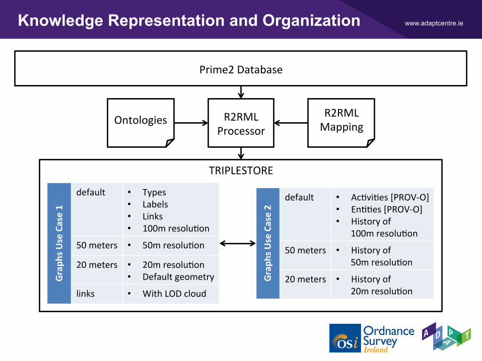
www.adaptcentre.ie Knowledge Representation and Organization
Ontologies• Features and Geometries based on GeoSPARQL• Provenance using Statute Instruments based on PROV-O• Static and dynamic boundaries (and their relationships)• Necessary ontologies developed and published
Workshops with DPER and CSO on a URI Strategy• Information Resources vs. Non-Information Resources• Using Prime2’s GUIDs and a hint of the instance’s nature
Cleverly using (named) graphs to support both use cases Mapping the Prime2 database to RDF with R2RML
www.adaptcentre.ie
TRIPLESTORE
Knowledge Representation and Organization
Prime2Database
OntologiesR2RMLMapping
R2RMLProcessor
Grap
hsUseCase1
default • Types• Labels• Links• 100mresoluBon
50meters • 50mresoluBon
20meters • 20mresoluBon• Defaultgeometry
links • WithLODcloud
Grap
hsUseCase2
default • AcBviBes[PROV-O]• EnBBes[PROV-O]• Historyof
100mresoluBon
50meters • Historyof50mresoluBon
20meters • Historyof20mresoluBon

www.adaptcentre.ie Example evolution of boundaries
B
C D
A
B
C D
A <http://data.example.com/feature/A> a geo:Feature ; rdfs:label "A" ; geo:hasGeometry [ a geo:Geometry ; geo:asWKT "MULTIPOLYGON (((0 1, 0 2, 3 2, 3 1, 0 1)))"^^geo:wktLiteral ] .<http://data.example.com/feature/B> … .<http://data.example.com/feature/C> … .<http://data.example.com/feature/D> … .
<http://data.example.com/feature/A> a geo:Feature ; rdfs:label "A" ; geo:hasGeometry [ a geo:Geometry ; geo:asWKT "MULTIPOLYGON (((1 1, 1 2, 3 2, 3 1, 1 1)))"^^geo:wktLiteral ; prov:wasGeneratedBy <http://data.example.com/change/1> ; prov:wasRevisionOf [ a geo:Geometry ; geo:asWKT "MULTIPOLYGON (((0 1, 0 2, 3 2, 3 1, 0 1)))"^^geo:wktLiteral ] ] .<http://data.example.com/feature/B> … .<http://data.example.com/feature/C> … .<http://data.example.com/feature/D> … .
<http://data.example.com/change/1> a prov:Activity ; prov:endedAtTime "2000-01-01T12:00:00"^^xsd:dateTime ; prov:startedAtTime"2000-01-01T12:00:00"^^xsd:dateTime ; prov:used <http://data.example.com/instrument/1> .
<http://data.example.com/instrument/1> a prov:Entity ; <http://purl.org/dc/elements/1.1/date> "2000-01-01" ; <http://purl.org/dc/elements/1.1/identifier> "1" ; <http://purl.org/dc/elements/1.1/title> "Change A" .
LegalInstrumentordering
changeofA’sboundaryon2000/01/01
Simplified example. Different graphs are used for different resolutions. Types for activities and entities omitted.

www.adaptcentre.ie Conceptual Architecture of the LD Platform
Proxy Server
TPFServer
TPFWeb
Client
Linked Data
Frontend
Website (dumps) Ontologies
SPARQL Endpoint
Triplestore
TPF Client

www.adaptcentre.ie Conceptual Architecture of the LD Platform

www.adaptcentre.ie Ongoing work…
• Publication of boundary data used by CENSUS 2011 • EDs,Towns, Settlements,
etc. published as Linked Data and linked with http://data.cso.ie/
• Dynamic vs. Static boundary datasets
• Merge of North and South Tipperary • Creation of links with DBpedia,GeoNames, TCD Library, etc.
• Creation of a spatial component to a pollution dataset

www.adaptcentre.ie Conclusion and Future Directions
We have used OSi’s Prime2 dataset to publish their authoritative geospatial data as Linked Data on the Web by creating R2RML mappings using ontologies that extend GeoSPARQL, and PROV-O.
Future directions include: • Transforming the geometries of buildings, the evolution
thereof, and how to link with the documents that inform the OSi of these changes (“closed” Linked Data)
• Access control mechanisms for such “Closed” Linked Data

www.adaptcentre.ie Team
OrdnanceSurveyIreland
ÉamonnClintonLorraineMcNerney
ADAPTThemeEandDLab
Dr.AtulNauByalDr.ChristopheDebruyneProf.DeclanO’SullivanDr.PeterLavin
ADAPTPMTheme
AoifeBradyClareConranDeclanMcKibbenSineadMadden
References
ChristopheDebruyne,EamonnClinton,LorraineMcNerney,AtulNauByal,DeclanO'Sullivan:ServingIreland'sGeospaBalInformaBonasLinkedData.InternaBonalSemanBcWebConference(Posters&Demos)2016ChristopheDebruyne,DeclanO'Sullivan:R2RML-F:TowardsSharingandExecuBngDomainLogicinR2RMLMappings.LDOW@WWW2016Prime2:DataConceptsandDataModelOverview.Tech.rep.,OrdnanceSurveyIreland(2014),hbp://www.osi.ie/wp-content/uploads/2015/04/Prime2-V-2.pdf