Embed Size (px)
Citation preview

www.delwp.vic.gov.au
Glenelg Estuary and Discovery Bay Ramsar Site
Management Plan

AcknowledgementsGavin Prentice, Jarred Obst, Helen Arundel, Adam Bester and Stephen Ryan (Glenelg Hopkins Catchment Management Authority), Bernadette Hoare and Don Tumney (Parks Victoria), Andrea White, Garry Peterson and Peter Lawson (DELWP), Leanne Wilkinson (Commonwealth Department of Environment and Energy), Nelson Coastcare Group, local landholders, the Nelson and Tarragal communities and the Gunditj Mirring Traditional Owner Aboriginal Corporation provided valuable input to the development of the management plan.Symbols for diagrams courtesy of the Integration and Application Network (ian.umces.edu/symbols), University of Maryland Centre for Environmental Science.
AuthorsButcher, R., Hale, J., Brooks, S. and Cottingham, P.
CitationDepartment of Environment, Land, Water and Planning (2017). Glenelg Estuary and Discovery Bay Ramsar Site Management Plan. Department of Environment, Land, Water and Planning, East Melbourne, Victoria.
Steering committee membershipThe steering committee was comprised of the following: Gavin Prentice, Helen Arundel and Adam Bester (Glenelg Hopkins Catchment Management Authority), Andrea White and Peter Lawson (DELWP), Bernadette Hoare (Parks Victoria) and the Commonwealth Department of Environment and Energy.
Photo creditGlenelg Estuary looking east along Discovery Bay, October 2015, © Marcel Hoog Antink© The State of Victoria Department of Environment, Land, Water and Planning 2017
This work is licensed under a Creative Commons Attribution 4.0 International licence. You are free to re-use the work under that licence, on the condition that you credit the State of Victoria as author. The licence does not apply to any images, photographs or branding, including the Victorian Coat of Arms, the Victorian Government logo and the Department of Environment, Land, Water and Planning (DELWP) logo. To view a copy of this licence, visit http://creativecommons.org/licenses/by/4.0/
ISBN 978-1-76047-945-9 (pdf/online)
DisclaimerThis publication may be of assistance to you but the State of Victoria and its employees do not guarantee that the publication is without flaw of any kind or is wholly appropriate for your particular purposes and therefore disclaims all liability for any error, loss or other consequence which may arise from you relying on any information in this publication.
AccessibilityIf you would like to receive this publication in an alternative format, please telephone the DELWP Customer Service Centre on 136186, email [email protected], or via the National Relay Service on 133 677 www.relayservice.com.au. This document is also available on the internet at www.delwp.vic.gov.au.

Glossary......................................................................................................................................................... 3
Abbreviations................................................................................................................................................. 6
1 Introduction and planning context..........................................................................................................7
1.1 Purpose of the management plan....................................................................................................71.1.1 Ecological character.................................................................................................................... 71.1.2 Objectives of the plan.................................................................................................................. 91.1.3 Ramsar documentation...............................................................................................................9
1.2 Relevant legislation and policy......................................................................................................101.2.1 International............................................................................................................................... 101.2.2 National....................................................................................................................................... 121.2.3 Victorian...................................................................................................................................... 121.2.4 Regional strategies and plans..................................................................................................14
1.3 About this management plan.........................................................................................................151.3.1 Principles of the planning process..........................................................................................151.3.2 Stakeholder involvement...........................................................................................................15
2 Glenelg Estuary and Discovery Bay Ramsar Site................................................................................17
2.1 Location and land management....................................................................................................17
2.2 Ramsar criteria met......................................................................................................................... 19
2.3 Ecological character and values....................................................................................................222.3.1 Critical components, processes and services........................................................................22
2.4 Maintaining ecological character and Limits of Acceptable Change (LAC)...............................24
3 Management priorities........................................................................................................................... 26
3.1 Method............................................................................................................................................. 263.1.1 Establishing the context............................................................................................................263.1.2 Identifying risks.........................................................................................................................273.1.3 Analysing risks.......................................................................................................................... 273.1.4 Stakeholder involvement...........................................................................................................29
3.2 Ranking priority values for management......................................................................................29
3.3 Ranking priority threats for management.....................................................................................30
3.4 Knowledge gaps.............................................................................................................................. 32
4 Management actions and targets..........................................................................................................33
4.1 Method............................................................................................................................................. 33
5 Monitoring, evaluation, reporting and improvement...........................................................................39
5.1 Framework....................................................................................................................................... 39
5.2 Condition monitoring...................................................................................................................... 39
5.3 Intervention monitoring..................................................................................................................41
5.4 Evaluation and reporting................................................................................................................41
6 Governance and implementation..........................................................................................................42
6.1 Governance..................................................................................................................................... 42
Contents
Glenelg Estuary and Discovery Bay Ramsar SiteManagement Plan
1

6.2 Implementation................................................................................................................................ 426.2.1 Implementation planning...........................................................................................................426.2.2 Ramsar Coordinating Committee.............................................................................................426.2.3 Resourcing implementation......................................................................................................42
6.3 Communication............................................................................................................................... 43
References................................................................................................................................................... 44
Appendix A: Stakeholders..........................................................................................................................46
Appendix B: Risk Assessment...................................................................................................................48
Risk assessment for the freshwater management unit............................................................................49
Risk assessment for the Glenelg estuary management unit...................................................................55
Risk assessment for the Beach and Dune fields management unit........................................................60
Appendix C: Prioritisation of values..........................................................................................................63
Appendix D: Prioritisation of threats.........................................................................................................68
Appendix E: Resource Condition Targets.................................................................................................72
Appendix F: Cross reference of Management Strategies with priority values, threats and knowledge gaps........................................................................................................................................... 76
2 Glenelg Estuary and Discovery Bay Ramsar SiteManagement Plan

Definitions of words associated with ecological character descriptions (DEWHA 2008) and references cited within unless otherwise indicated).
Benefits Benefits/services are defined in accordance with the Millennium Ecosystem Assessment definition of ecosystem services as "the benefits that people receive from ecosystems (Ramsar Convention 2005), Resolution IX.1 Annex A).See also “Ecosystem Services”.
Biodisparity The range of morphologies and reproductive styles in a community. The biodisparity of a wetland community is determined by the diversity and predictability of its habitats in time and space.
Biogeographic region
A scientifically rigorous determination of regions as established using biological and physical parameters such as climate, soil type, vegetation cover, etc. (Ramsar Convention 2005).
Biological diversity
The variability among living organisms from all sources including, inter alia, terrestrial, marine and other aquatic ecosystems and the ecological complexes of which they are part; this includes diversity within species (genetic diversity), between species (species diversity), of ecosystems (ecosystem diversity), and of ecological processes. This definition is largely based on the one contained in Article 2 of the Convention on Biological Diversity (Ramsar Convention 2005).
Change in ecological character
Defined as the human-induced adverse alteration of any ecosystem component, process, and/or ecosystem benefit/service (Ramsar Convention 2005a), Resolution IX.1 Annex A).
Community An assemblage of organisms characterised by a distinctive combination of species occupying a common environment and interacting with one another (ANZECC and ARMCANZ 2000).
Community Composition
All the types of taxa present in a community (ANZECC and ARMCANZ 2000).
Conceptual model
Wetland conceptual models express ideas about components and processes deemed important for wetland ecosystems (Gross 2003).
Contracting Parties
Countries that are Member States to the Ramsar Convention on Wetlands; 159 as at March 2010. Membership in the Convention is open to all states that are members of the United Nations, one of the UN specialised agencies, or the International Atomic Energy Agency, or is a Party to the Statute of the International Court of Justice.
Critical stage Meaning stage of the life cycle of wetland-dependent species. Critical stages being those activities (breeding, migration stopovers, moulting etc.) which if interrupted or prevented from occurring may threaten long-term conservation of the species (Ramsar Convention 2005).
Ecological character
The combination of the ecosystem components, processes and benefits/services that characterise the wetland at a given point in time. [Within this context, ecosystem benefits are defined in accordance with the MA definition of ecosystem services as “the benefits that people receive from ecosystems”.] (Resolution IX.1 Annex A) (Ramsar 2012).
Ecosystems The complex of living communities (including human communities) and non-living environment (Ecosystem Components) interacting (through Ecological Processes) as a functional unit which provides inter alia a variety of benefits to people (Ecosystem Services) (Millennium Ecosystem Assessment 2005).
Ecosystem components
Include the physical, chemical and biological parts of a wetland (from large scale to very small scale, for example habitat, species and genes) (Millennium Ecosystem Assessment 2005).
Ecosystem processes
The changes or reactions which occur naturally within wetland systems. They may be physical, chemical or biological. (Ramsar Convention 1996), Resolution VI.1 Annex A). They include all those processes that occur between organisms and within and between populations and communities, including interactions with the non-living environment that result in existing ecosystems and bring about changes in ecosystems over time (Australian Heritage Commission 2002).
Ecosystem services
The benefits that people receive or obtain from an ecosystem. The components of ecosystem services are provisioning (for example food and water), regulating (for example flood control), cultural (for example spiritual, recreational), and supporting (for example nutrient cycling,
Glossary
Glenelg Estuary and Discovery Bay Ramsar SiteManagement Plan
3

ecological value). (Millennium Ecosystem Assessment 2005). See also “Benefits”.
Electrical conductivity
See Salinity below
Endemic Endemic species (Guidelines for Criterion 7) - a species that is unique to one biogeographical region, i.e., it is found nowhere else in the world. A group of fishes may be indigenous to a subcontinent with some species endemic to a part of that subcontinent (Ramsar Convention 2009).
Endemism The ecological state of being unique to a geographic location – see endemic.
Fluvial geomorphology
The study of water-shaped landforms (Gordon et al. 1999).
Geomorphology The study of the evolution and configuration of landforms.
Indigenous species
A species that originates and occurs naturally in a particular country (Ramsar Convention 2005).
Limits of Acceptable Change
The variation that is considered acceptable in a particular component or process of the ecological character of the wetland without indicating change in ecological character which may lead to a reduction or loss of the criteria for which the site was Ramsar listed’ (modified from definition adopted by (Phillips 2006).
List of Wetlands of International Importance ("the Ramsar List")
The list of wetlands which have been designated by the Ramsar Contracting Party in which they reside as internationally important, according to one or more of the criteria that have been adopted by the Conference of the Parties.
Ramsar City in Iran, on the shores of the Caspian Sea, where the Convention on Wetlands was signed on 2 February 1971; thus the Convention's short title, "Ramsar Convention on Wetlands".
Ramsar Criteria Criteria for Identifying Wetlands of International Importance, used by Contracting Parties and advisory bodies to identify wetlands as qualifying for the Ramsar List on the basis of representativeness or uniqueness or of biodiversity values.
Ramsar Convention
Convention on Wetlands of International Importance especially as Waterfowl Habitat. Ramsar (Iran), 2 February 1971. UN Treaty Series No. 14583. As amended by the Paris Protocol, 3 December 1982, and Regina Amendments, 28 May 1987. The abbreviated names "Convention on Wetlands (Ramsar, Iran, 1971)" or "Ramsar Convention" are more commonly used.
Ramsar Information Sheet (RIS)
The form upon which Contracting Parties record relevant data on proposed Wetlands of International Importance for inclusion in the Ramsar Database; covers identifying details like geographical coordinates and surface area, criteria for inclusion in the Ramsar List and wetland types present, hydrological, ecological, and socioeconomic issues among others, ownership and jurisdictions, and conservation measures taken and needed.
Ramsar List The List of Wetlands of International Importance.
Ramsar Sites Wetlands designated by the Contracting Parties for inclusion in the List of Wetlands of International Importance because they meet one or more of the Ramsar Criteria.
Waterbirds "birds ecologically dependent on wetlands" (Article 1.2). This definition thus includes any wetland bird species. However, at the broad level of taxonomic order, it includes especially:penguins: Sphenisciformes.divers: Gaviiformes;grebes: Podicipediformes;wetland related pelicans, cormorants, darters and allies: Pelecaniformes;herons, bitterns, storks, ibises and spoonbills: Ciconiiformes;flamingos: Phoenicopteriformes:screamers, swans, geese and ducks (wildfowl): Anseriformes;wetland related raptors: Accipitriformes and Falconiformes;
4 Glenelg Estuary and Discovery Bay Ramsar SiteManagement Plan

wetland related cranes, rails and allies: Gruiformes;hoatzin: Opisthocomiformes;wetland related jacanas, waders (or shorebirds), gulls, skimmers and terns: Charadriiformes;coucals: Cuculiformes; andwetland related owls: Strigiformes.
Wetlands Are areas of marsh, fen, peatland or water, whether natural or artificial, permanent or temporary with water that is static or flowing, fresh, brackish or salt, including areas of marine water the depth of which at low tide does not exceed six metres (Ramsar Convention 1987).
Wetland types As defined by the Ramsar Convention’s wetland classification system [http://www.ramsar.org/ris/key_ris.htm#type].
CAMBA China Australia Migratory Bird Agreement
CMA Catchment Management Authority
DEDJTR Department of Economic Development, Jobs, Transport and Resources (Victorian Government)
DELWP Department of Environment, Land, Water and Planning (Victorian Government), formerly Department of Environment and Primary Industries
DEPI Department of Environment and Primary Industries, now Department of Environment, Land, Water and Planning (Victorian Government)
DEWHA Department of Environment, Water, Heritage and the Arts, now the Department of the Environment and Energy (Australian Government)
DoEE Department of the Environment and Energy (Australian Government)
ECD Ecological Character Description
EPA Environment Protection Authority, Victoria
EPBC Act Environment Protection and Biodiversity Conservation Act 1999
Glenelg Hopkins CMA
Glenelg Hopkins Catchment Management Authority
IUCN International Union for Conservation of Nature
JAMBA Japan Australia Migratory Bird Agreement
LAC Limits of Acceptable Change
MAs Management Actions
MCA Multiple Criteria Analysis
MER Monitoring, Evaluation and Reporting
PSC Project Steering Committee
RCT Resource Condition Target
RIS Ramsar Information Sheet
RSMP Ramsar Site Management Plan
ROKAMBA Republic of Korea Australia Migratory Bird Agreement
SRW Southern Rural Water
TAG Technical Advisory Group
VWMS Victorian Waterway Management Strategy
Abbreviations
Glenelg Estuary and Discovery Bay Ramsar SiteManagement Plan
5

This
Ramsar Management Plan (RSMP) has been prepared as part of the nomination process for listing the Glenelg Estuary and Discovery Bay wetlands under the Ramsar Convention. It is intended that this document, together with the Ecological Character Description (ECD) guide the management, conservation and maintenance of the ecological character and wise use of the site. A consultative and collaborative process was undertaken develop the RSMP. The outputs of this process are documented in two products:
1. A Glenelg Estuary and Discovery Bay Ramsar Site Management Plan (this document), including a full description of the plan’s development and technical appendices, and
2. A Glenelg Estuary and Discovery Bay Ramsar Site Management Plan summary document for a general audience that briefly outlines the process, and details the management strategies and responsibilities.
1.1 Purpose of the management plan
1.1.1 Ecological characterThe Convention on Wetlands of International Importance Especially as Waterfowl Habitat (Ramsar, Iran, 2 February 1971) encourages the designation of sites containing representative, rare or unique wetlands, or wetlands that are important for conserving biological diversity, to the List of Wetlands of International Importance (Ramsar List). These sites are commonly known as Ramsar sites. The Ramsar Convention, as it is commonly known, is an international intergovernmental treaty with the broad aims of halting and, where possible, reversing, the worldwide loss of wetlands and to conserve those that remain through wise use and management (DSEWPAC 2012).
Under the terms of the Convention contracting parties nominate wetlands to be designated as Wetlands of International Importance, with nominated sites required to meet at least one of nine listing criteria. The act of designating a wetland as a Ramsar site carries with it certain obligations, including managing the site to maintain its “ecological character” and to have procedures in place to detect if any threatening processes are likely to, or have altered, the “ecological character”. The Ramsar Convention has defined “ecological character” and “change in ecological character” as (Ramsar Convention 2005):
“Ecological character is the combination of the ecosystem components, processes and benefits/services [CPS] that characterise the wetlands at a given point in time” and
“…change in ecological character is the human induced adverse alteration of any ecosystem component, process and or ecosystem benefit/service.”
Under Article 3.2 of the Ramsar Convention a notification of change is required if the ecological character of a site has changed, is changing, or is likely to change as the result of human activities. The Australian Government has established a number of principles to guide notifications in Australia (DEWHA 2009):
• Assessment of change will be undertaken with respect to critical components, processes and benefits/services of the ecological character of the site.
• An assessment of change to support a notification must be based on best available science.
• The fact that a site was undergoing human-induced ecological character change at the time of listing does not preclude the need for an assessment, and possible notification of change, if there is evidence of significant ongoing adverse ecological change.
• Where the natural variability of a site cannot reasonably be established for the critical component process, benefit or service against which change is being assessed, a notification, if made, will only be on the basis of 'is likely to' change.
1 Introduction and planning context
6 Glenelg Estuary and Discovery Bay Ramsar SiteManagement Plan

• A notification will not be made where the apparent character change has been identified as arising from the use of inadequate data sets at the time of listing.
• A notification will not be made where climate change is the principal cause of identified ecological character change.
Glenelg Estuary and Discovery Bay Ramsar SiteManagement Plan
7

Ramsar: A network of sitesThere is a network of over 2000 Ramsar wetlands across the globe that is dedicated to sustaining biodiversity and wise use. One of the important functions, and a primary purpose for the establishment of the Convention, is to protect sites in different countries that are important for migratory birds.The migratory birds that visit Australia are part of the East Asian-Australasian Flyway and most of them migrate from breeding grounds in North-east Asia and Alaska to non-breeding grounds in Australia and New Zealand, covering the journey of 10 000 kilometres twice in a single year.
The lifecycle of most international migratory shorebirds involves (Bamford et al. 2008): breeding in May to August (northern
hemisphere) southward migration to the southern
hemisphere (August to November) feeding and foraging in the southern
hemisphere (August to April), and northward migration to breeding grounds
(March to May).During both northward and southward migration, birds may stop at areas on route to rest and feed. These stopovers are referred to as “staging” areas and are important for the birds’ survival. In addition, birds on their first southward migration that have not yet reached breeding maturity may remain in Australia over the southern winter period.Other migratory species that are supported by the Glenelg Estuary and Discovery Bay Ramsar Site include species such as the double-banded plover, which migrate between New Zealand and Australia spending the non-breeding (winter) season on Australian shores.The Glenelg Estuary and Discovery Bay Ramsar Site supports over 30 species that are international migrants and listed under migratory agreements with China, Japan and the Republic of Korea. Important habitats within the site include the intertidal flats and saltmarsh where migratory waders feed. High tide roosting sites, where waders can rest are also important.
Migratory waders in Australia need to build up their energy reserves for the homeward journey. This means that they not only require abundant food sources, but they need to minimise their activity. Disturbance of waders when roosting or feeding may result in a significant loss of energy. This may even compromise their ability to build up enough reserves to complete the return journey to breeding grounds. Disturbance of migratory shorebirds may occur as a result of driving on beaches or in saltmarsh and intertidal areas, unleashed dogs, recreational fishing (in some instances); boating and jet skiing and any activity in the intertidal zone that causes significant noise or light. Migratory waders are also susceptible to predation by foxes and cats. Populations of many migratory wader species are in decline, primarily through loss of habitat in breeding and staging areas outside Australia. This makes them more vulnerable while in Australia and increases the importance of maintaining habitat and conditions at overwintering sites. Residents and visitors to the Glenelg Estuary and Discovery Bay need to work together to help protect and conserve these important species.
8 Glenelg Estuary and Discovery Bay Ramsar SiteManagement Plan

1.1.2 Objectives of the planThe primary purpose of the Glenelg Estuary and Discovery Bay Ramsar Site Management Plan (Glenelg RSMP) is to maintain ecological character and promote wise use of the site. Wise use is defined by the Convention as (Ramsar Convention 2005):
“the maintenance of their ecological character, achieved through the implementation of ecosystem approaches, within the context of sustainable development”.
The Glenelg Estuary and Discovery Bay Ramsar Site support a number of ecological, socio-economic and cultural values. Socio-economic and cultural values of the site (e.g. tourism, recreation) result from maintaining the condition of the Ramsar site. This plan has adopted the principle that by maintaining (or improving) ecological character, the socio-economic and cultural values associated with the Ramsar site will also be conserved, within the concept of wise use. Therefore, the primary objective of the Glenelg RSMP is:
“To maintain, and where necessary improve, the ecological character of the Glenelg Estuary and Discovery Bay Ramsar Site and promote wise and sustainable use”.
1.1.3 Ramsar documentationRamsar site management to maintain ecological character is reliant on a number of key documents and processes as illustrated in Figure 1. The three key documents are:
Ramsar Information Sheet (RIS) - compiled for each site it documents the essential information related to the site and its management. The Administrative Authority of each Contracting Party submits the RIS to the Ramsar Secretariat. In the case of Australia, the Administrative Authority is the Australian Government Department of the Environment and Energy (DoEE). The Parties have committed to providing updated RIS information for their Ramsar sites every six years, or on the occasion of any significant change in a site’s ecological character. A RIS is being compiled as part of the nomination process for the Glenelg Estuary and Discovery Bay Ramsar Site.
Ecological Character Description (ECD) – provides a more detailed and quantitative description of ecological character for a Ramsar site. The ECD establishes a benchmark, at the time of listing, which in the case of Glenelg Estuary and Discovery Bay Ramsar Site is 2017. The ECD identifies the critical components, processes and services of the site (critical CPS) and sets limits of acceptable change (LAC). The Australia Government has developed a standard method for describing ecological character (Department of the Environment, Water, Heritage and the Arts 2008). The ECD for Glenelg Estuary and Discovery Bay Ramsar Site was completed as part of the nomination process (Butcher et al. 2017a).
Management plan – documents the management strategies required to protect and restore the ecological character of a Ramsar site. In Australia, the Environment Protection and Biodiversity Conservation Act 1999 (EPBC Act) establishes the framework for management of Australian Ramsar sites, and Schedule 6 of Environment Protection and Biodiversity Conservation Regulations 2000 outlines the principles relevant to the preparation of Ramsar site management plans (Text Box 1).
Ramsar Rolling Review – The Department of Environment and Energy has developed a three-year Ramsar Rolling Review program for reporting the status of the ecological character of Australia’s Ramsar sites. The broad aims of the Ramsar Rolling Review program are to:
• Review and report on the status of the ecological character of Australia’s Ramsar sites.
• Be a tool to assist managing sites in order to maintain their ecological character, improving links between ecological character, site management plans and monitoring programs for critical CPS and associated threats.
• Provide input to a database of baseline and threat data.
• Record updates as knowledge gaps are addressed and refine LAC.
• Highlight issues and facilitate assessment of a potential change of character, focussing on proactive management before the situation requires notification.
• Identify broad trends or common threats across site and jurisdiction boundaries.
Glenelg Estuary and Discovery Bay Ramsar SiteManagement Plan
9

Figure 1: The Glenelg Estuary and Discovery Bay Ramsar Site in context of other requirements for the management of Ramsar sites.
1.2 Relevant legislation and policy
1.2.1 International
Ramsar ConventionThe Convention on Wetlands of International Importance, otherwise known as the Ramsar Convention, was signed in Ramsar Iran in 1971 and came into force in 1975. It provides the framework for local, regional and national actions, and international cooperation, for the conservation and wise use of wetlands. Wetlands of International Importance are selected on the basis of their international significance in terms of ecology, botany, zoology, limnology and/or hydrology.
Migratory bird bilateral agreements and conventions Australia is party to a number of bilateral agreements, initiatives and conventions for the conservation of migratory birds, which are relevant to the Glenelg Ramsar Site. The bilateral agreements are:
• Japan-Australia Migratory Bird Agreement (JAMBA) – The agreement between the Government of Australia and the Government of Japan for the Protection of Migratory Birds in Danger of Extinction and their Environment, 1974;
• China-Australia Migratory Bird Agreement (CAMBA) - The Agreement between the Government of Australia and the Government of the People's Republic of China for the Protection of Migratory Birds and their Environment 1986;
• Republic of Korea-Australia Migratory Bird Agreement (ROKAMBA) - The Agreement between the Government of Australia and the Republic of Korea for the Protection of Migratory Birds and their Environment, 2006; and
• The Bonn Convention on Migratory Species (CMS) - The Bonn Convention adopts a framework in which countries with jurisdiction over any part of the range of a particular species co-operate to prevent migratory species becoming endangered. For Australian purposes, many of the species are migratory birds.
10 Glenelg Estuary and Discovery Bay Ramsar SiteManagement Plan

Text Box 1: Australian Ramsar Management Principles (Environment Protection and Biodiversity Conservation Regulations 2000).
1 General principles 1.01The primary purpose of management of a declared Ramsar wetland must be, in accordance with the
Ramsar Convention: (a) to describe and maintain the ecological character of the wetland, and (b) to formulate and implement planning that promotes:
(i) conservation of the wetland, and (ii) wise and sustainable use of the wetland for the benefit of humanity in a way that is
compatible with maintenance of the natural properties of the ecosystem. 1.02Wetland management should provide for public consultation on decisions and actions that may have a
significant impact on the wetland. 1.03Wetland management should make special provision, if appropriate, for the involvement of people who:
(a) have a particular interest in the wetland, and (b) may be affected by the management of the wetland.
1.04Wetland management should provide for continuing community and technical input. 2 Management planning
2.01At least one management plan should be prepared for each declared Ramsar wetland. 2.02A management plan for a declared Ramsar wetland should:
(a) describe its ecological character, and (b) state the characteristics that make it a wetland of international importance under the Ramsar
Convention, and (c) state what must be done to maintain its ecological character, and (d) promote its conservation and sustainable use for the benefit of humanity in a way that is compatible
with maintenance of the natural properties of the ecosystem, and (e) state mechanisms to deal with the impacts of actions that individually or cumulatively endanger its
ecological character, including risks arising from: (i) physical loss, modification or encroachment on the wetland, or (ii) loss of biodiversity, or (iii) pollution and nutrient input, or (iv) changes to water regimes, or (v) utilisation of resources, or (vi) introduction of invasive species, and
(f) state whether the wetland needs restoration or rehabilitation, and (g) if restoration or rehabilitation is needed--explain how the plan provides for restoration or
rehabilitation, and (h) provide for continuing monitoring and reporting on the state of its ecological character, and (i) be based on an integrated catchment management approach, and (j) include adequate processes for public consultation on the elements of the plan, and (k) be reviewed at intervals of not more than 7 years.
3 Environmental impact assessment and approval 3.01This principle applies to the assessment of an action that is likely to have a significant impact on the
ecological character of a Ramsar wetland (whether the action is to occur inside the wetland or not). 3.02Before the action is taken, the likely environmental impact of the action on the wetland's ecological
character should be assessed under a statutory environmental impact assessment and approval process. 3.03The assessment process should:
(a) identify any part of the ecological character of the wetland that is likely to be affected by the action, and
(b) examine how the ecological character of the wetland might be affected, and (c) provide adequate opportunity for public consultation.
3.04An action should not be approved if it would be inconsistent with: (a) maintaining the ecological character of the wetland, or (b) providing for the conservation and sustainable use of the wetland.
3.05Approval of the action should be subject to conditions, if necessary, to ensure that the ecological character of the wetland is maintained.
3.06The action should be monitored by the authority responsible for giving the approval (or another appropriate authority) and, if necessary, enforcement action should be taken to ensure compliance with the conditions.
Glenelg Estuary and Discovery Bay Ramsar SiteManagement Plan
11

1.2.2 National
Native Title Act 1993This Act provides for the recognition and protection of native title, as "It establishes ways in which future dealings affecting native title may proceed and to set standards for those dealings”. It provides for, or permits, the validation of past acts, and intermediate period acts, invalidated because of the existence of native title.
Environment Protection and Biodiversity Conservation Act 1999 (EPBC Act)The EPBC Act regulates actions that will have or are likely to have a significant impact on any matter of national environmental significance, which includes the ecological character of a Ramsar wetland (EPBC Act 1999 s16(1)). An action that will have or is likely to have a significant impact on a Ramsar wetland will require an environmental assessment and approval under the EPBC Act. An ‘action’ includes a project, a development, an undertaking or an activity or series of activities (http://www.environment.gov.au/epbc/index.html).
The EPBC Act establishes a framework for managing Ramsar wetlands, through the Australian Ramsar Management Principles (EPBC Act 1999 s335), which are set out in Schedule 6 of the Environment Protection and Biodiversity Conservation Regulations 2000. These principles are intended to promote national standards of management, planning, environmental impact assessment, community involvement, and monitoring, for all of Australia’s Ramsar wetlands in a way that is consistent with Australia’s obligations under the Ramsar Convention. Some matters protected under the EPBC Act are not protected under local or state/territory legislation, for example, many migratory birds are not specifically protected under State legislation. Species listed under international treaties JAMBA, CAMBA and CMS have been included in the List of Migratory species under the Act. Threatened species and communities listed under the EPBC Act may also occur, or have habitat in the Ramsar site; some species listed under State legislation as threatened are not listed under the EPBC Act as threatened, usually because they are not threatened at the national (often equivalent to whole-of-population) level. The Regulations also cover matters relevant to the preparation of management plans, environmental assessment of actions that may affect the site, and the community consultation process.
1.2.3 Victorian
The Environment Protection Act 1970This Act establishes the Environment Protection Authority and makes provision for the Authority's powers, duties and functions. These relate to improving the air, land and water environments by managing waters, control of noise and control of pollution. State Environment Protection Policies (SEPPs) are subordinate legislation made under the provisions of the Act. SEPP (Waters of Victoria) sets water quality objectives to protect the beneficial uses of inland waters. SEPP (Waters of Victoria) is currently under review.
Environment Effects Act 1978This Act establishes the processes for assessment of proposed projects (works) that are capable of having a significant effect on the environment. The Act establishes the role of the Minister for Planning to decide whether an Environmental Effects Statement (EES) is required. The roles and responsibilities of the EES process are described in the Ministerial guidelines for Assessment of Environmental Effects under the Environment Effects Act 1978 (DSE 2006). The guidelines specify the criteria for referring a project to the Minister for decision on the requirement for an EES. These include effects of potential long term change to the ecological character of a Ramsar site.
National Parks Act 1975 This Act makes provision for the preservation and protection of the natural environment including wilderness areas and remote and natural areas. This includes the protection and preservation of indigenous flora and fauna and of features of scenic or archaeological, ecological, geological, historic or other scientific interest in those parks. It allows for the study of ecology, geology, botany, zoology and other sciences relating to the
12 Glenelg Estuary and Discovery Bay Ramsar SiteManagement Plan

conservation of the natural environment in those parks; and for the responsible management of the land in those parks.
Wildlife Act 1975This Act ensures procedures are in place to protect and conserve Victoria's wildlife and prevent any taxa of wildlife from becoming extinct. The Act also provides for the establishment of State Game Reserves. Regulations under the Act ensure that the consumptive use or other interactions with flora and fauna in Victoria does not threaten the sustainability of wild populations, while facilitating cultural and recreational pursuits in a humane, safe, ethical and sustainable manner.
Crown Land (Reserves) Act 1978This Act provides the framework for the administration and management of Crown land reserves including nature conservation reserves. The Act also deals with the making of regulations, committees of management and leasing and licensing.
Flora and Fauna Guarantee Act 1988This Act provides a legislative and administrative framework for the conservation of biodiversity in Victoria through the provision for the listing of threatened taxa, communities and potentially threatening processes. It requires the preparation of action statements for listed species, communities and potentially threatening processes and sets out the process for implementing interim conservation orders to protect critical habitats. The Act also seeks to provide programs for community education in the conservation of flora and fauna and to encourage co-operative management of flora and fauna.
Water Act 1989This Act establishes rights and obligations in relation to water resources and provides mechanisms for the allocation of water resources. This includes the consideration of environmental water needs of rivers and wetlands as well as for human uses such as urban water supply and irrigation.
Catchment and Land Protection Act 1994 (CaLP Act)This Act sets up a framework for the integrated management and protection of catchments. It establishes processes to encourage and support community participation in the management of land and water resources and provides for a system of controls on noxious weeds and pest animals.
Fisheries Act 1995This Act provides a framework for the regulation, management and conservation of Victorian fisheries. It deals with commercial and recreational licences, fish culture, noxious aquatic species, research and development, the declaration and management of fisheries reserves; and the preparation of management plans for individual fisheries, declared noxious aquatic species and fisheries reserves.
Aboriginal Heritage Act 2006This Act provides for the protection and management of Victoria’s Aboriginal heritage. It establishes the Victorian Aboriginal Heritage Council to advise the Minister in the management of cultural heritage and registered Aboriginal parties. The Act also deals with cultural heritage management plans, cultural heritage permits and agreements. The Act also includes enforcement provisions and processes for handling dispute resolution. This includes the review of certain decisions through the Victorian Civil and Administrative Tribunal (VCAT).
Planning and Environment Act 1987The Act sets out procedures for preparing and amending the Victoria Planning Provisions and planning schemes, obtaining permits under schemes, settling disputes, enforcing compliance with planning schemes, and other administrative procedures.
Glenelg Estuary and Discovery Bay Ramsar SiteManagement Plan
13

Heritage Rivers Act 1992The main purpose of this Act is to prohibit the construction in heritage river areas of new impoundments, barriers and structures that impede the passage of water and fauna. Heritage rivers are designated because of their very high nature conservation, recreational, social or cultural value or because of a combination of these values.
1.2.4 Regional strategies and plans There are a very large number of regional and local plans that are relevant to the management of the Glenelg Ramsar Site. A few of the most significant of these are outlined here. Further information can be found on the Glenelg Hopkins CMA’s website (http://www.ghcma.vic.gov.au/master-nav/publications/plans ) .
Victorian Waterway Management StrategyThe 2013 Victorian Waterway Management Strategy (VWMS) provides the framework for government, in partnership with the community, to maintain or improve the condition of rivers, estuaries and wetlands so that they can continue to provide environmental, social, cultural and economic values for all Victorians (DEPI 2013). The framework is based on regional planning processes and decision-making, within the broader system of integrated catchment management in Victoria.
Regional Catchment Strategy (RCS) and the Ngootyoong Gunditj Ngootyoong Mara South West Management PlanRCSs are statutory documents under the CaLP Act that provide the overarching framework for land, water and biodiversity management and conservation in each of the ten catchment management regions of Victoria. The Glenelg Hopkins RCS (Glenelg Hopkins CMA 2013) outlines a 50-year vision that aims to foster an environment where:
• Biodiversity thrives and clean water is available for environmental, economic and social uses.
• Environmental assets are valued and protected from threats, and the impacts of pest plants and animals are greatly reduced.
• The community is proactive and aware, and understands that ecologically sustainable management of its natural resources is essential to a high quality of life.
More recently, the Ngootyoong Gunditj Ngootyoong Mara South West Management Plan (Parks Victoria 2015) has been developed to provide a strategic guide for managing and protecting the parks, reserves and Aboriginal community owned properties (referred to as Indigenous Protected Areas - IPAs) of south-western Victoria. The plan reflects a new approach by setting goals and priorities across National, State, Coastal, Forest, Marine and Regional parks and reserves and IPAs, including the cooperative management of Mount Eccles National Park. This approach recognises Gunditjmara Countries (River Forest Country, Stone Country, Forest Country and Sea Country) and natural ecosystems in developing strategies for management. The strategies take a practical approach that recognises both the purpose of the parks and reserves and the Gunditjmara Traditional Owners’ role in managing these special areas.
Regional Waterway Strategy (RWS)RWSs have been developed for each of the ten catchment management regions in Victoria. These sit within the VWMS and RCS frameworks and set out the detailed planning and management for rivers, estuaries and wetlands across the State. Ramsar management planning has been embedded in the RWSs for the majority of the Ramsar sites in Victoria.
Development of the Glenelg Hopkins Waterway Strategy (Glenelg Hopkins CMA 2014) was guided by the direction and principles outlined in the VWMS and drew on the experience gained and lessons learned during the implementation of the Glenelg Hopkins River Health Strategy 2004-2009 to:
• Improve the integrated waterway management planning framework,
• Incorporate estuaries and wetlands in regional waterway planning arrangements,
• Improve the regional priority setting process,
14 Glenelg Estuary and Discovery Bay Ramsar SiteManagement Plan
• Incorporate increased flexibility for responding to varying climatic conditions, and
• Better integrate environmental water management with other waterway management activities.
1.3 About this management plan
1.3.1 Principles of the planning processThe Glenelg RSMP was developed through a consultative process that involved a large number of stakeholders with an interest in the Glenelg Estuary and the wetlands of Discover Bay. The process included a series of workshops and briefings that ensured that local knowledge and best-available scientific information was included in both the ECD and this plan. The guiding principles for the development of the Glenelg RSMP included:
• Stakeholder involvement – this plan has been developed with the input of a broad range of stakeholders through every phase. Consultation included traditional owners, agencies with a role in management of the site, technical experts, non-government organisations and the general community (see below).
• Evidence-based approach – best available knowledge was used to underpin the development of this plan including input to the risk assessment and prioritisation of values and threats.
• Precautionary principle – lack of full scientific certainty was not seen as a reason for postponing cost-effective measures to prevent environmental degradation.
• Building on existing activities – there are a large number of activities already being implemented within the region, catchment and site to maintain and improve condition and ecosystem services. This plan seeks to build on these existing activities rather than duplicate effort.
• Adaptive management – the plan life is for eight years, with a mid-term review after four years. A monitoring program included and the principles of monitor, evaluate, report and improve have been adopted.
In building on existing initiatives, the management objectives included in the Glenelg RSMP sought to be consistent with existing management plans. At the State level this includes the Victorian Waterway Management Strategy (VWMS), which guides the management of rivers, estuaries and wetlands (DEPI 2013). At a regional level, the Glenelg Ramsar site is within the area covered by the Ngootyoong Gunditj Ngootyoong Mara South West management plan (Parks Victoria 2015), and the Glenelg Hopkins Waterway Strategy (Glenelg Hopkins CMA 2014).
At a local level, the site falls predominantly in the Lower Glenelg National Park and Discovery Bay Coastal Park. Existing management plans of relevance to the Glenelg RSMP in terms of maintaining or improving ecological character include the Glenelg Hopkins Waterway Strategy (Glenelg Hopkins CMA 2014), the Glenelg Estuary Management Plan (Glenelg Hopkins CMA 2006), and the Ngootyoong Gunditj Ngootyoong Mara South West Management Plan (Parks Victoria 2015).
1.3.2 Stakeholder involvementThe importance of stakeholder engagement in development of management plans for Ramsar sites is recognised by the Convention and in the Australian Ramsar Management Principles (Text Box 1). In development of this management plan, stakeholders were involved at every stage of the process. A communications and engagement strategy was developed prior to the commencement of the project and refined as necessary.
The major groups involved in the development of this project were:
• Traditional owners: GHCMA work with the Gunditj Mirring Traditional Owners Aboriginal Corporation under a memorandum of understanding on all projects, including the development of the Glenelg RSMP. The Gunditjmara people are one of the primary guardians, keepers and knowledge holders of Aboriginal cultural heritage for the area. Gunditjmara representatives were directly consulted in June 2015 to discuss how traditional knowledge might be introduced to the project. The goals of the project were presented. Information on cultural values of the proposed new site was provided via a combination of
Glenelg Estuary and Discovery Bay Ramsar SiteManagement Plan
15

meetings and correspondence. The outcome of this process was a statement illustrating importance of Country and support for the nomination.
• Technical experts: Two separate groups made up the technical experts: the project steering committee (PSC) (comprising representatives from GHCMA, Parks Victoria, DELWP Integrated Water and Catchments, DELWP Barwon South West, Commonwealth Department of Environment and Energy) and regional technical committee (comprising technical experts from GHCMA, Parks Victoria, Nature Glenelg Trust, DELWP regional staff, scientists and consultants). Four steering committee meetings and three technical workshops were held. The technical workshops facilitated the input of specialist, local expertise into crucial aspects of the ECD, including information used to describe the ecological character of the Ramsar site, as well as prioritising the environmental values and threats within the RSMP. The technical workshops were also used to update participants on the development of the Ramsar documents.
• Community: People were made aware of the proposed nomination via the GHCMA website, information provided on community notice boards, email updates and by newspaper articles and radio interviews. All communications directed stakeholders to the GHCMA website which was regularly updated and provided an email address for people to contact the project team. Adjacent landholders and local groups with an interest in the proposed listing were contacted directly by letter and email. The primary mode of consultation with these groups and the community was via public workshops and small group and one-on-one meetings. Six public workshops were held in the town of Nelson between June 2015 and June 2016. All issues raised during the community workshops were addressed during the workshop and additional information, if required, was provided in written form after the meeting. When issues raised involved values and threats at the site these comments were used to inform the RSMP.
A list of stakeholders can be found in Appendix A.
16 Glenelg Estuary and Discovery Bay Ramsar SiteManagement Plan

Glenelg Estuary and Discovery Bay Ramsar SiteManagement Plan
17

2 Bay Ramsar SiteA complete description of the ecological character of the Glenelg Estuary and Discover Bay Ramsar Site is contained in the ecological character description (ECD) (Butcher et al. 2017a). A summary of this information relevant to the management plan for the site is provided below.
2.1 Location and land management
The Glenelg Estuary and Discovery Bay Ramsar Site is situated in western Victoria in the Glenelg Hopkins catchment management area. The region supports various agricultural industries (e.g. livestock grazing, soft and hardwood plantations), and includes major population centres at Portland and Hamilton in Victoria and Mount Gambier in South Australia. The site is located adjacent to the Victorian-South Australian border, approximately 430 kilometres west of Melbourne (Figure 2). Nelson is the township closest to the Ramsar site (Figure 3).
4 Glenelg Estuary and Discovery
18 Glenelg Estuary and Discovery Bay Ramsar SiteManagement Plan

Figure 2: Location of the Glenelg Estuary and Discovery Bay Ramsar site.
Glenelg Estuary and Discovery Bay Ramsar SiteManagement Plan
19

Figure 3: Close-up of Ramsar site boundary near the town of Nelson, showing the 600m stretch of river exclude from the site, the estuary mouth and Oxbow Lake.The Ramsar site covers approximately 22,289 hectares and comprises the western part of Lower Glenelg National Park from the South Australian border to the Nelson - Winnap Road, most of the Discovery Bay Coastal Park and the Nelson Streamside Reserve. The boundary excludes the portions of the Glenelg Estuary that lie within South Australia as well as 600 metres of the estuary channel adjacent to the town of Nelson (see Figure 3). More detail is provided in the Boundary Description for the Site (Brooks, 2015).
Major land uses adjacent to the site include forestry (primarily pine plantations) and grazing of improved and natural pastures. Land tenure within the Ramsar site is summarised in (Table 1). Both the National Park and Coastal Park are managed by Parks Victoria in partnership with local stakeholders (Parks Victoria 2015).
Table 1: Land tenure within Glenelg Estuary and Discovery Bay Ramsar Site.
Description Area (hectares)
Crown land – National Park managed by Parks Victoria in partnership with local stakeholders 13,276
Crown land – Crown reserve 36
Crown land – Coastal Park managed by Parks Victoria in partnership with local stakeholders 8,977
Total area 22,289
The Ramsar site has three main systems (management units) represented by wetlands within freshwater, estuarine and beach environments:
1. The Long Swamp wetlands, Bridgewater Lakes and other freshwater systems along approximately 50 kilometres of the Discovery Bay Coastal Park (Freshwater wetlands management unit).
2. The Glenelg Estuary and associated Oxbow Lake and streamside reserve at the township of Nelson (excluding the Crown Land Reserve in the immediate vicinity of Nelson), along with the western part of the Lower Glenelg National Park from the South Australian border to the Nelson - Winnap Road and excludes the Moleside Creek portion of the national park (Estuary management unit).
20 Glenelg Estuary and Discovery Bay Ramsar SiteManagement Plan

3. The dune fields and beach down to the low water mark along the Discovery Bay Coastal Park (Beach and dune field management unit), extending from the South Australian border to Discovery Bay Road.
2.2 Ramsar criteria met
The Glenelg Estuary and Discovery Bay Ramsar Site meets five of the nine Ramsar listing criteria.
Criterion 1
A wetland should be considered internationally important if it contains a representative, rare, or unique example of a natural or near-natural wetland type found within the appropriate biogeographic region.
The application of this criterion must be considered in the context of the bioregion within which the site is located. The South East Coast (Victoria) Drainage Division extends from the New South Wales – Victorian border along the coast to the Millicent basin in South Australia. The Ramsar guidance for this criterion indicates that the justification should be based on wetland type and hydrology. The Glenelg Estuary and Discover Bay Ramsar Site meets this criterion with respect to rare wetland types in the bioregion (and globally) peat wetlands and dune slack wetlands; and the Glenelg Estuary, which is considered a good near-natural representative of wetland type E in the bioregion.
The peatlands of the Ramsar site are fen wetlands (i.e. groundwater dependent) and largely have an intact hydrology. These are a rare wetland type, globally with nearby Piccaninnie Ponds Karst Wetlands Ramsar site perhaps representing the only other significant fen wetland in the bioregion.
The site is geomorphically significant as it includes a humid dune slack system, which is rare in Australia. The dune slack system supports peatlands, wet grassland habitats and temporary pools, which are identified by the Ramsar Convention as globally significant (Ramsar Convention 2003).
The geomorphology and hydrology of the estuary section of the Ramsar site is unusual within the bioregion and can be considered a good representative of wetland type E. It is characterised by:
• being the longest estuary in Victoria (75 kilometres),
• having a groundwater dominated hydrology, and
• significant areas of limestone gorge for most of its length upstream of Nelson.
This site clearly meets criterion 1, through its unique combination of geomorphological features and wetland types, including groundwater dependent ecosystems which include several of the most globally threatened wetland types: fens, wet grasslands and temporary pools.
Criterion 2
A wetland should be considered internationally important if it supports vulnerable, endangered, or critically endangered species or threatened ecological communities.
In the Australian context, it is recommended that this criterion should only be applied to nationally threatened wetland dependent species and communities, listed under the EPBC Act 1999 or the International Union for Conservation of Nature (IUCN 2012a) Red List. The site regularly supports one threatened ecological community, two species of threatened plant and seven threatened animal species (Table 2).
Glenelg Estuary and Discovery Bay Ramsar SiteManagement Plan
21

Table 2: Threatened wetland dependent species recorded at the Glenelg Estuary and Discover Bay Ramsar Site. CE = critically endangered; En = endangered; Vu = vulnerable: listed under EPBC Act and IUCN Red List (IUCN 2015) May 2015. Strength: Certain = annual records; High = records for most years but some data gaps, high level of confidence still at the site.
Community/Species IUCN EPBC Records Strength of evidence for regularly supports/residency
Communities
Subtropical and temperate coastal saltmarsh
Vu 2008, 2014 Certain – recent vegetation mapping indicates this threatened community occurs in the estuary section of the site.
Plants
Maroon Leek-orchid - Prasophyllum frenchii
En 2004, 2008, 2014
High – lack of recent records, however believed still to be present. Twenty four plants recorded in 2004 (Duncan 2010), and 216 recorded in the Discovery Bay Park in 2008 (VBA extract).
Swamp greenhood - Pterostylis tenuissima
Vu 2004, 2008, 2009, 2010 2014
High – located at a number of sites within the Ramsar site (Dickson et al. 2012)
Waterbirds
Australasian bittern - Botaurus poiciloptilus
En En 1979, 1991, 1992, 2003, 2012, 2015
High – there are a number of records for this cryptic species from within the site, within the Long Swamp Complex and the Fringing areas of the Glenelg Estuary (records from BirdLife Australia Bird Atlas).
Fairy tern – Sterna nereis nereis
Vu Vu 1999, 2001-2004
High – records from 1999 – 2004; but no more recent records.
Hooded plover - Thinornis rubricollis
Vu En Biennial count since 1980
Certain – solid long term records for this species at the site. The number of birds recorded at the site increased between 2010 and 2012 (Ewers et al. 2011, Mead et al. 2012).
Fish
Yarra pygmy perch – Nannoperca obscura
Vu Vu 2012, 2014, 2015
Certain – recorded in substantial numbers in recent surveys Lake Moniboeng and Long Swamp.
Amphibians
Growling grass frog - Litoria raniformis
En Vu 1998, 1999, 2012
High – Audio calls from Long Swamp (Bachmann et al. 2013). Earlier records from Swan Lake, Lake Moniboeng and Bridgewater Lakes (Bachmann et al. 2013).
Invertebrates
Ancient greenling – Hemiphlebia mirablis
En 2008-2014 Certain – recent investigations estimate a very large population at Long Swamp (Cordero Rivera 2014). Records are available from Long Swamp 2008-2010 (Crowther 2011).
There are records for several other species from the site that may be regularly supported, but for which there is insufficient evidence at this stage to include them in the justification for this criterion. This includes two internationally migratory shorebirds the curlew sandpiper (Calidris ferruginea) and Eastern curlew (Numenius madagascariensis) and the Southern bent-wing bat (Miniopterus orianae bassanii). There are very sparse records and low counts of both the bird species from within the site, despite semi-regular counts of shorebirds. In the case of the southern bent-wing bat, the species is present in several caves along the
22 Glenelg Estuary and Discovery Bay Ramsar SiteManagement Plan

Glenelg Estuary; it is, however, not considered wetland dependent and so cannot contribute to the meeting of this criterion.
In 2015, the species Eastern galaxias (Galaxiella pusilla) was revised and the species that occurs in the Ramsar site is now called the little galaxias (Galaxiella toourtkoourt). While the little galaxias is listed under State threatened species legislation, it is not currently listed at the national or international level.
The Glenelg Estuary and Discovery Bay Ramsar Site clearly meets this criterion supporting at least eight listed species and one ecological community on a regular basis.
Criterion 4
A wetland should be considered internationally important if it supports plant and/or animal species at a critical stage in their life cycles, or provides refuge during adverse conditions.
The long term intention of this criterion is to ensure wetlands within the Ramsar estate include those which are vital for providing habitat during critical life stages (breeding and migration) and or in periods of adverse conditions (Ramsar Convention 2009).
Specifically, the site provides habitat for 95 waterbird species including 24 species listed under international agreements: CAMBA (24), JAMBA (24), ROKAMBA (21), BONN (21) and 34 Australian migratory or marine species. Beach nesting birds such as hooded plover (Thinornis rubricollis) and red-capped plover (Charadrius ruficapillus) are regularly recorded nesting on the dunes of the Discovery Bay Coastal Park, albeit in low numbers (Ewers et al. 2011, Mead et al. 2012). The site also supports 14 species of native fish which are diadromous, migrating between habitats for part of their lifecycle. In addition, the permanent wetlands of the Long Swamp complex and Bridgewater Lakes provide habitat for obligate aquatic species when the surrounding landscape is dry and during drought conditions.The site meets this criterion for supporting migratory species of waterbirds and fish as well as beach nesting birds and providing freshwater habitat when the surrounding region is dry.
Criterion 8
A wetland should be considered internationally important if it is an important source of food for fishes, spawning ground, nursery and/or migration path on which fish stocks, either within the wetland or elsewhere, depend.
Under the guidelines for this criterion coastal wetlands are identified as important feeding, spawning nursery habitats and as such supporting essential ecological processes for fish stocks, even if they do not necessarily harbour large adult fish populations themselves (Ramsar Convention 2009).
The Glenelg Estuary provides nursery habitat for several species of recreationally important fish including black bream (Acanthopagrus butcheri) and estuary perch (Macquaria colonorum). In particular, the seasonal opening and closing of the estuary is considered important in providing conditions for spawning of black bream (Jenkins et al. 2008).
In addition, the site supports at least 14 species of fish that migrate between habitats for parts of their lifecycle including: short finned eel (Anguilla australis), tupong (Pseudaphritis urvillii), estuary perch (Macquaria colonorum) and common galaxias (Galaxias maculatus). A recent tagging study has indicated that mulloway that feed in the Glenelg Estuary may migrate up to 400 kilometres to the Murray Mouth to spawn (Lieschke and Stoessel, in prep.).
The site provides a range of fish species with sources of food, spawning grounds and nurseries, and acts as a migration path on which diadromous fishes of the region depend, as such it is deemed to meet this criterion.
Glenelg Estuary and Discovery Bay Ramsar SiteManagement Plan
23

Criterion 9
A wetland should be considered internationally important if it regularly supports one percent of the individuals in a population of one species or subspecies of wetland-dependent non-avian animal species.
The application of this criterion relies on estimates of the total population of non-avian wetland dependent species. While several species may be supported in numbers greater than one percent of the population (e.g. growling grass frog (Litoria raniformis); Yarra pygmy perch (Nannoperca obscura)), there is insufficient data to determine population sizes. As such an assessment against this criterion for these species is not possible at this time.
There are recent data on the Ancient greenling (Hemiphlebia mirabilis) with the species first recorded at Long Swamp in 2008 and a detailed mark and recapture program completed in 2013 (Cordero-Rivera 2015). The species is the only extant representative of this superfamily of damselfly globally.
To date, 24 sites have records for the species across Victoria (19), South Australia (3) and Tasmania (2) (Crowther 2011, D. Crowther unpublished data), however four of the Victorian sites lack recent sightings. The sub-population at Long Swamp likely represents more than 1% of the total global population for this species, possibly as much as 5%, as Long Swamp represents the largest known area of habitat with the species present (D. Crowther unpublished data, Crowther 2011, Cordero Rivera 2013, Cordero-Rivera 2015).
This criterion is met on the basis of the site supporting more than 1% of the population of ancient greenling.
2.3 Ecological character and values
Ecological character at the Ramsar site is defined by a number of critical components, processes and services (CPS).
2.3.1 Critical components, processes and servicesThe critical components, processes and services of the site are:
• Components: – Hydrology– Vegetation type and extent– Fish diversity and abundance– Waterbird diversity and abundance
• Process:– Stratification
• Services:– Special features (dune slacks)– Supports a diversity of wetland types– Supports threatened species– Provides physical habitat for waterbirds– Ecological connectivity
HydrologyThe hydrology of the Ramsar site results from a complex interaction of surface and groundwater expression as well as local rainfall-runoff, particularly in the freshwater wetland and estuary management units. System hydrology is crucial to the functioning of the estuary, and the freshwater wetlands that include ecologically important fens.
Vegetation type and extentThe site is characterised by three major wetland dependent vegetation types that are critical to defining the character of the Ramsar site. These are (Butcher et al. 2017a):
1. Coastal saltmarsh associated with the Glenelg Estuary and Oxbow Lake.
2. Freshwater sedgelands and tall marsh vegetation associated with the Long Swamp wetlands.
3. Lake bed macrophytes - submerged macrophyte communities of the permanent lakes.
24 Glenelg Estuary and Discovery Bay Ramsar SiteManagement Plan

Fish diversity and abundanceWhilst a comprehensive understanding of the fish diversity and abundance across all wetland types within the Ramsar site is considered a knowledge gap (Butcher et al. 2017a), available data records list 47 native fish species from 26 families at the site. Of the 47 native species, 28 species are considered to be regularly supported across the site. The most common species (in terms of abundance) vary according to wetland type, with the estuarine species small-mouthed hardy-head (Atherinosoma microstoma) and black bream (Acanthopagrus butcheri) common in Oxbow Lake, and the freshwater species southern pygmy perch (Nannoperca australis) dominating the community in Long Swamp (Veale 2014, 2016).
Spawning and recruitment of most fish species within the site remains a knowledge gap. There is however, good evidence that the common galaxias (Galaxias maculatus) is a self-sustaining breeding population within the site and that a number of fish species move between habitats during different parts of their lifecycles. There is a good understanding of the spawning and recruitment of black bream in the Glenelg Estuary, with stratification and freshwater inflows important for success.
Waterbird diversity and abundanceA total of 95 waterbird species have been recorded within the Ramsar site (Butcher et al. 2017a), noting that this list excludes vagrants and species for which the site does not provide core habitat (e.g. pelagic seabirds and penguins). Twenty-four species are listed under international migratory agreements although only 20 species are true international migrants with the remaining species resident within their Australian range. Waterbird breeding within the Ramsar site is a significant knowledge gap with respect to species numbers and important locations and habitats.
There are breeding records of nine waterbird species from within the site, from incidental observations. Little tern used the estuary regularly as a breeding colony in the past, with the first nesting being observed in 1988 and yearly from 2000 to 2004 (Smith and Smith 2001, Smith and Smith 2002, Campbell and Christie 2009). In 2003/04 both little and fairy terns were observed nesting together. Little terns typically breed in small colonies of up to 50 individuals; however, the colonies established at the Glenelg Estuary were small with typically 6-8 breeding pairs.
StratificationThe lower Glenelg Estuary can be described as a seasonally closed salt-wedge estuary (Glenelg Hopkins CMA 2006). The interaction of fresh river flow and saline marine tides creates a salt wedge within the estuary. The position and behaviour of this salt wedge is affected by river flow volume and tidal cycles. For example, under an ebb tide when the estuary is open, river water extends further downstream in a thick layer over the denser seawater wedge, whilst in a flood tide the salt wedge is pushed further up the estuary. When the estuary is closed and tidal exchange ceases, the stratification (distinct layers of fresh and saline water) becomes more stable and a distinct halocline forms. This prevents the mixing of bottom water layers with the surface water, lowers oxygen exchange from the atmosphere and results in a decline in dissolved oxygen in bottom waters. The seasonal nature of freshwater inflows and opening of the estuary creates a cycle of salinity and dissolved oxygen in the estuary (see description in Butcher et al. 2017a).
Ecosystem servicesThe Glenelg Estuary and Discovery Bay Ramsar Site provides several cultural and socio-economic values. The site is significant for the Gunditjmara people who provided the following supporting statement for the Ramsar nomination:
“Gunditjmara people welcome a Ramsar listing for the areas identified in the Bocara Estuary and Koonang Gunditj to exist alongside our continued connection to Gunditj identified by the Ramsar nomination and our rights and interests recognised in 1997 and 2007 by Commonwealth and Victorian legislation.”
The site is also important in terms of recreational and tourist values. Visitor numbers to the area, including the Lower Glenelg National Park and Discovery Bay Coastal Park can exceed 100,000 annually, while visitor numbers at townships such as Nelson can exceed 20,000 annually (Glenelg Shire Council 2005, Parks
Glenelg Estuary and Discovery Bay Ramsar SiteManagement Plan
25

Victoria 2006). Tourism contributes over $37 Million to the local economy annually and is a significant contributor to local employment.
Supporting services are those which are considered essential for the production of all other ecosystem services such as water cycling, nutrient cycling and habitat for biota. These services will generally have an indirect benefit to humans or a direct benefit over a long period of time. A summary of the critical supporting services of the site is provided in Table 3.
Table 3: Summary of critical supporting services within the Glenelg Estuary and Discovery Bay Ramsar Site.
Critical ecosystem service
Description
Diversity of wetland types The site comprises a network of interconnected wetland types including freshwater permanent wetlands, intermittently inundated marshes, estuarine waters and intertidal sandy beaches.
Special geomorphic features
The site is significant for a number of geological and geomorphic features; in particular the dune slack system is rare, if not unique within the bioregion.
Provides physical habitat (for waterbirds)
The site provides a network of habitats for waterbird feeding, roosting and breeding. Species that are supported by the site represent a wide range of functional groups (e.g. fishers, waders, ducks) each with different habitat requirements.
Threatened wetland species and ecosystems
One nationally listed ecological community and eight nationally or internationally listed species of conservation significance are supported by the site.
Ecological connectivity The wetlands in the site are hydrologically and ecologically connected. The connection between the marine, estuarine and freshwater components is particularly important for fish migration and reproduction.
2.4 Maintaining ecological character and Limits of Acceptable Change (LAC)
The mechanism against which change in ecological character is assessed is via comparison with Limits of Acceptable Change (LAC). LAC are defined by Phillips (2006) as:
“…the variation that is considered acceptable in a particular measure or feature of the ecological character of the wetland. This may include population measures, hectares covered by a particular wetland type, the range of certain water quality parameter, etc. The inference is that if the particular measure or parameter moves outside the ‘limits of acceptable change’ this may indicate a change in ecological character that could lead to a reduction or loss of the values for which the site was Ramsar listed. In most cases, change is considered in a negative context, leading to a reduction in the values for which a site was listed”.
The following should be considered when developing and assessing LAC:
LAC are a tool by which ecological change can be measured. However, LAC do not constitute a management regime for the Ramsar site.
Exceeding or not meeting LAC does not necessarily indicate that there has been a change in ecological character within the meaning of the Ramsar Convention. However, exceeding or not meeting LAC may require investigation to determine whether there has been a change in ecological character.
While the best available information was used to prepare the ECD and define LAC for the site, a comprehensive understanding of site character may not be possible as, in many cases, only limited information and data is available for these purposes. The LAC may not accurately represent the variability of the critical components, processes, benefits or services under the management regime and natural conditions that prevailed at the time the site was listed as a Ramsar wetland.
LAC can be updated as new information becomes available to ensure they more accurately reflect the natural variability (or normal range for artificial sites) of critical components, processes, benefits
26 Glenelg Estuary and Discovery Bay Ramsar SiteManagement Plan
or services of the Ramsar wetland. The formal process for this is via the Ramsar Rolling Review, which is a three yearly assessment of ecological character at each Ramsar site (Butcher et al. 2011).
The LAC for the Glenelg Estuary and Discovery Bay Ramsar Site were established in the ECD for critical components, processes and services (Butcher et al. 2017a) and are summarised in Table 4.
Table 4: LAC for the Glenelg Estuary and Discovery Bay Ramsar Site.
Critical CPS Limit of Acceptable Change
Hydrology Bridgewater Lakes, Lake Moniboeng, Swan Lake, Malseed Lake and Cain Flat Swamp will not dry.The Glenelg Estuary will not remain closed for three consecutive years or open for greater than five years.
Stratification See LAC for hydrology (Glenelg Estuary)
Vegetation type and extent Vegetation extent will not fall below the following:Coastal saltmarsh - 13 hectaresFreshwater sedges and tall marsh - 470 hectares, with at least 270 hectares of Baumea sedgelands.
Fish diversity and abundance Native fish within the Ramsar site will represent each of the following life history strategies: estuarine dependent, estuarine opportunists, marine migrants, diadromous and obligate freshwater species.
Waterbird diversity and abundance
Absence of the following waterbird guilds in any three out of five years: Ducks, swans and grebes Fishers Large wading birds Australian waders International waders Gulls and terns
Sanderling abundance falls below 0.7% of the global population in three out of five years.
Diversity of wetland types See LAC for vegetation type and extent and hydrology.
Special geomorphic features: dune slack
No LAC
Physical habitat for waterbirds See LAC for vegetation type and extent and hydrology.
Threatened species: plants Absence of maroon leek-orchid (Prasophyllum frenchii) and or swamp greenhood (Pterostylis tenuissima) in three consecutive targeted surveys.
Threatened species: fish Absence of Yarra pygmy perch (Nannoperca obscura) in any three out of five targeted surveys.
Threatened species: birds Absence of hooded plover (Thinornis rubricollis) in three out of five years.
Threatened species: growling grass frog
Absence of growling grass frog (Litoria raniformis) in any three out of five targeted surveys.
Threatened species: ancient greenling
See LAC for vegetation type and extent (Baumea sedgelands).
Ecological connectivity See LAC for hydrology (Glenelg Estuary) and fish (continued presence of diadromous fish).
Glenelg Estuary and Discovery Bay Ramsar SiteManagement Plan
27

Priority threats and values for management were identified through a process that included a risk assessment.
2.5 Method
The risk assessment process adopted for this project was consistent with the Australian/New Zealand Standard: Risk Management (AS/NZS 4360:2004; Standards Australia and Standards New Zealand 2004) and the Standards Australia Handbook: Environmental risk management - principles and process (HB 203-2000; Standards Australia and Standards New Zealand 2006). The risk assessment approach follows a structured and iterative process, with the following steps:
1. Establish the context – existing values and environmental conditions;
2. Identify risks – threats and associated potential impacts; and
3. Analyse risks – assign likelihoods and consequences to determine level of risk.
2.5.1 Establishing the contextA review of existing published and unpublished information relevant to the Glenelg Estuary and the Discovery Bay wetlands was undertaken to identify and summarise the important ecological, social and economic values, current condition and potential threats to ecological character. A separate risk assessment was completed for each of the three management units.
The purpose of the risk assessment was to identify priority values and threats as the basis for identifying strategic actions for the Glenelg RSMP. The ECD (Butcher et al. 2017a) provided a benchmark for values and threats, which was augmented by local knowledge for the RSMP. The risk assessment was underpinned by local knowledge and expert opinion and was used to identify priority values and threats. This process is illustrated in Figure 4.
Figure 4: Process of prioritising values and threats and the role of the risk assessment.
2 Management priorities
28 Glenelg Estuary and Discovery Bay Ramsar SiteManagement Plan

2.5.2 Identifying risksAn impact pathway approach was adopted for identifying and analysing risks. This uses a hierarchical process to identify potential risks as follows:
• Threats (threatening activities) – actions in the Ramsar site or catchment that could affect ecological character;
• Stressors – the physical or chemical changes that could arise as a result of an activity;
• Effects – the potential responses caused by the stressors.
This allows for clear identification of the underlying causes of risks and threats to ecological character of the Ramsar site, separating the threat from the impact.
2.5.3 Analysing risksImpact pathways were developed that integrated each level of the hierarchy and these formed the basis of a formal risk analysis process. Likelihood and consequence were assigned to each impact pathway in its entirety. See below for an example for an impact pathway:
Pressures Stressors Impact
Climate change: Drought Altered water regimes Results in decreased health and extent of wetland vegetation
Questions were put to stakeholder and agency technical staff to estimate the likelihood and consequence, for example: what is the likelihood that drought will result in altered water regimes and that this will result in decreased health and extent of wetland vegetation? What are the consequences of this with respect to the ecological character of the Ramsar site?
Likelihood and consequence descriptions used in this assessment are provided in Table 5 and Table 6, respectively, with the risk matrix (Table 7) showing how they combine to score the overall risk. A number of ground rules for the risk assessment were established:
• The risk assessment was focussed on assessing risks to ecological character over the next 15 years.
• In assessing each impact pathway all likely future changes (population, land use, climate change) were considered.
• Where possible all decisions were based on multiple lines of evidence.
Table 5: Likelihood
Almost certain Likely Possible Unlikely Rare
Is expected to occur in most circumstances
Will probably occur in most circumstances
Could occur Could occur but not expected
Occurs only in exceptional circumstances
Glenelg Estuary and Discovery Bay Ramsar SiteManagement Plan
29
Table 6: Consequence
Category Insignificant Minor Moderate Major Extreme
Ecosystem Function (need to consider resilience and resistance)
Alteration or disturbance to ecosystem within natural variability. Ecosystem interactions may have changed but it is unlikely that there would be any detectable change outside natural variation
Localised measurable changes to the ecosystem components without a major change in function (no loss of components or introduction of new species that affects ecosystem function). Recovery (if relevant) in less than 1 year.
Widespread measurable changes to the ecosystem components without a major change in function (no loss of components or introduction of new species that affects ecosystem function). Recovery (if relevant) in 1 to 2 years.
Widespread measureable changes to the ecosystem components with a major change in function. Recovery (i.e. within historic natural variability) in 3 to 10.
Long term and possibly irreversible damage to one or more ecosystem function. Recovery, if at all, greater than 10 years.
Habitat, communities
Alteration or disturbance to habitat within natural variability. Less than 1% of the area of habitat affected or removed.
1 to 5% of the area of habitat affected in a major way or removed.
5 to 30% of the area of habitat affected in a major way or removed.
30 to 90% of the area of habitat affected in a major way or removed.
Greater than 90% of the area of habitat affected in a major way or removed.
Species Population size or behaviour may have changed but it is unlikely that there would be any detectable change outside natural variation / occurrence.
Detectable change to population size and / or behaviour, with no detectable impact on population viability (recruitment, breeding, recovery) or dynamics.
Detectable change to population size and / or behaviour, with no impact on population viability (recruitment, breeding, recovery) or dynamics.
Detectable change to population size and / or behaviour, with an impact on population viability and or dynamics.
Local extinctions are imminent / immediate or population no longer viable.
Social Short-term interruptions in recreational use (days) and perception as a high amenity place to live unaltered.
Recreational activities restricted and perceptions of amenity altered in a localised area for short-term (< 1 year)
Recreational activities restricted and perceptions of amenity altered in a localised area for > 1 year.
Long-term disruption to recreational activities and perceptions of amenity altered at a regional scale for 1 to 5 years.
Long-term disruption to recreational activities and perceptions of amenity altered for a regional scale for > 10 years.
Table 7: Risk matrix
Consequence
Likelihood
Insignificant Minor Moderate Major Extreme
Almost certain Negligible Medium High Extreme Extreme
Likely Negligible Medium Medium High Extreme
Possible Negligible Low Medium High High
Unlikely Negligible Low Low Medium Medium
Rare Negligible Negligible Negligible Low Medium
30 Glenelg Estuary and Discovery Bay Ramsar SiteManagement Plan

2.5.4 Stakeholder involvementA draft risk assessment for each management unit (Freshwater wetlands, Estuary and Beach and Dune field) was developed based on best available information by a team of wetland managers and scientists in consultation with experts on various aspects of the Ramsar site. This draft risk assessment was provided to the project steering committee (PSC) and technical advisory group (TAG) members for review. A two-day workshop was held in Warrnambool on 27th and 28th October 2015, at which participants were asked to review the impact pathways, and likelihood and consequence ratings for each impact pathway in their area of interest or expertise. At the workshop, the risk assessment was systematically worked through with discussion on the rankings and identified pathways until agreement was reached. Critical knowledge gaps were identified and documented for inclusion in the management plan. A number of risk rankings were deferred at the workshop for consultation with relevant scientific experts and representatives of the Gunditj Mara people:
• Fire vulnerability of threatened plant species (freshwater wetlands);
• Extent of cultural activities (all management units);
• Susceptibility of seagrass to reduced groundwater inputs (estuary).
Following the workshop, relevant experts from universities and research organisations were contacted to provide input to the risk assessment in their respective fields. The results of these conversations, together with the outputs of the workshop were used to produce a revised risk assessment for each habitat within each of the management units. The full risk assessment for each management unit is provided in Appendix B.
The project was introduced to local stakeholders at a meeting in Nelson on the 4th June 2015. A subsequent stakeholder workshop was held in Nelson on the 11th August 2015 (followed by meetings with individual stakeholders on the 12th August), where the risk assessment and values and threats prioritisation approach was outlined. Stakeholders were then provided with an opportunity to confirm their top five values and threats for each management unit. Discussions continued with stakeholders via a web forum established for the project, as well as via numerous telephone conversations and emails. Because of the low numbers at the 11th August workshop, the process was repeated at a subsequent workshop held at Nelson on the 29 th October 2015. Participants were again asked to identify and rank their top five priority values for each management unit. The scores for each value and threat were then summed and sorted in order from highest to lowest, and then categorised as High, Medium or Low (see Appendices B and C).
Results of the prioritisation were presented to technical and scientific staff from Parks Victoria and the Glenelg Hopkins CMA on the 17th December 2015. The results were presented to community stakeholders at a workshop held in Nelson on the 14th January 2016.
2.6 Ranking priority values for management
A multi-criterion analysis (MCA) was used to identify the highest priorities for protection or management for the next eight years (i.e. the life of the plan). Criteria adopted for prioritising values related to (Appendix C):
• Meeting Ramsar site management planning obligations to maintain ecological character (criteria 1 and 2);
• Importance to the broader community (criterion 3); and
• Values that have been identified as being at risk from threats at the site or in the catchment (criterion 4).
Ecological values identified for each management unit were those acknowledged as being critical to the ecological character of the Ramsar site in the ECD (Butcher et al. 2017a), as well as discussions with stakeholders (including Aboriginal representatives) and wetland managers and scientists. Attribution of values to each management unit relied on both data and local knowledge and was reviewed by Steering Committee members.
The prioritisation criteria were applied to each value relevant to each management unit and scores summed to rank values in order of priority for management. A sensitivity analysis that weighted criteria was
Glenelg Estuary and Discovery Bay Ramsar SiteManagement Plan
31

undertaken, but resulted in no significant changes in the ranking. Final scores were categorised into “high, medium and low” priorities (see Appendix C). High priority values for each management unit are presented in Table 8.
Table 8: Priority values for each management unit of the Glenelg Estuary and Discovery Bay Ramsar Site. High priority values for management are shaded.
ValueManagement units
Freshwater wetlands
Estuary Beach and dune fields
Hydrology: surface water regime X X X
Hydrology: groundwater regime X X
Vegetation: dune scrub X
Vegetation: coastal saltmarsh X
Vegetation: freshwater sedge/tall marsh X
Fish diversity and abundance X X X
Waterbird breeding X X X
Hydrological process that support wetland type and extent X X X
Threatened species: maroon Leek-orchid and Swamp greenhood X
Threatened species: fairy tern X X
Threatened species: hooded plover X
Threatened species: Yarra pygmy perch X
Threatened species: growling grass frog X
Threatened species: ancient greenling X
Supports priority wetland species: migratory waterbirds X
2.7 Ranking priority threats for management
The risk assessment described in Chapter 3 was used as a key input to a multi-criteria analysis used to identify priority threats for management over the next 8 years (i.e. the life of this management plan). Criteria incorporated into the analysis to identify high priority threats (Appendix D) related to:
• Risks to ecological character;
• Feasibility of management;
• Cost of implementing management actions; and
• Community priorities.
The prioritisation criteria were applied to each threat relevant to each management unit and scores summed to rank threats in order of priority for management. A sensitivity analysis that weighted criteria was undertaken, but resulted in no significant changes in the ranking. Final scores were categorised into “high, medium and low” priorities for management (see Appendix D). High priority threats for each of the three management units are presented in Table 9.
32 Glenelg Estuary and Discovery Bay Ramsar SiteManagement Plan
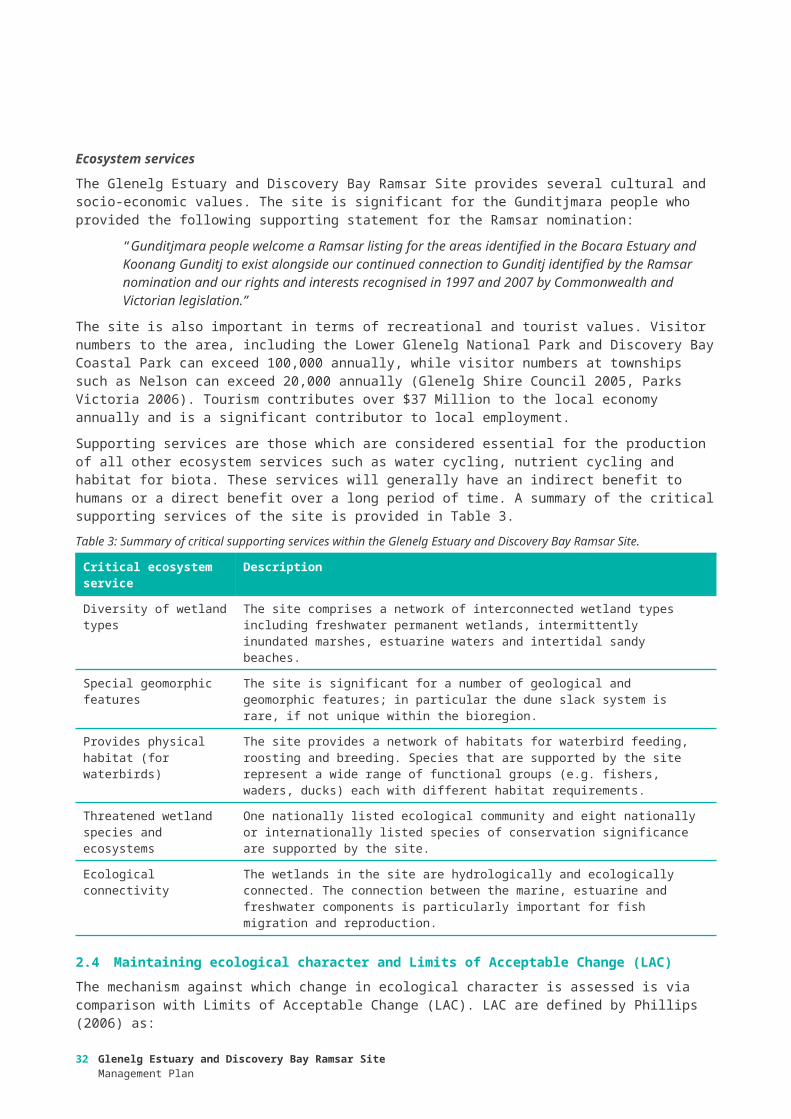
Table 9: Priority threats for each management unit of the Glenelg Estuary and Discovery Bay Ramsar Site. High priority values for management are shaded.
ThreatManagement units
Freshwater wetlands
Estuary Beach and dune fields
Invasive species: non-native non-woody weeds (e.g. phalaris, Sicilian sea lavender) X X X
Invasive species: native woody weeds (e.g. coastal wattle) X X X
Invasive species: non-native woody weeds (e.g. boxthorn) X X
Invasive species: non-native terrestrial animals (e.g. pigs, foxes) X X X
Invasive species: non-native aquatic animals (e.g. carp) X
Energy production and mining: oil and gas drilling: decreased groundwater levels1 X
Natural systems modification (e.g. inappropriate estuary openings): altered water regimes X
Natural systems modifications (wildfire): increased nutrients and sediments X
Climate change (sea level rise): increased ingress of marine water X X X
Climate change (extreme storm events): increased beach erosion X
Climate change (drought): altered water regimes X X
1 Assessed as a high priority threat by the community. However, with current controls in place the risk assessment, based on likelihood and consequence, rated this threat as negligible to low. Controls include that there is a permanent ban on fracking and a moratorium on conventional onshore gas exploration in Victoria until 2020. If this were to change in the future (e.g. if the moratorium was lifted), any proposed oil or gas drilling would be subject to State and Commonwealth environmental impact assessment processes. An EPBC Act referral would be required for any new activities that have the potential to impact the ecological character of a Ramsar site.
Glenelg Estuary and Discovery Bay Ramsar SiteManagement Plan
33

2.8 Knowledge gapsA number of knowledge gaps were identified when compiling the ECD and when considering threats to the ecological character of the Ramsar site. These are listed in Table 10.
Table 10: Summary of knowledge gaps and recommended actions.
Component / process
Knowledge Gap Recommended Action
Hydrology Understanding of the hydrology of the whole Ramsar site so that changes to surface and groundwater hydrology can be considered.The relative influence of the Kanawinka Fault to the east of the Ramsar site on the local hydrology.
Confirmation of the hydrology (including groundwater-surface water interactions) across the site is required to inform LAC and risk management (e.g. drought impacts).
Soils Fine scale spatial patterning of soils across the site. Baseline surveys of soils, particularly near main freshwater wetlands.
Fish Baseline survey data for Malseed and Swan Lakes. Inventory assessment required to inform LAC.
Investigation on fish breeding and nursery habitats across freshwater lakes and estuary.
Surveillance assessment required to strengthen case for criterion 4 and provide information related to connectivity (e.g. migration and breeding of diadromous fish).
Waterbirds Baseline records for breeding. Surveillance assessment required to strengthen criterion 4.
Relative importance and use of interconnected habitat for waterbirds.
Surveillance survey to confirm use of inter-connected habitats by waterbirds.
Vegetation Baseline survey data for emergent and submergent vegetation at Bridgewater Lakes, Lake Malseed and Swan Lake – likely to be a critical component, but no data.
Inventory assessment required to inform LAC.
Extent of weed infestations in each management unit
Surveillance assessment required to confirm the extent of weed species and response to management.
Invertebrates Macroinvertebrate community composition across all habitat types in the lower Glenelg Estuary, Oxbow Lake, and freshwater wetlands.
Base line surveys be undertaken to establish linkages between current and altered hydrological regimes at Long Swamp.
Conditions and habitat required for oviposition by ancient greenling.
Investigate conditions required for oviposition.
The relative importance of fish predation and potential changes associated with the restoration of hydrology in Long Swamp on ancient greenling.
Surveillance monitoring of Ancient greenling.
Understanding of the microinvertebrate community Inventory assessment across the site, low priority.
Amphibians Base line data on abundance and distribution lacking at Bridgewater Lakes, Malseed and Swan Lake, upper reaches of the Glenelg Estuary.
Inventory assessment across whole of site, including growling grass frog and swamp skink.
Phytoplankton
Extent and composition of algae and phytoplankton. Undertake baseline surveys of phytoplankton across the site.
34 Glenelg Estuary and Discovery Bay Ramsar SiteManagement Plan

2.9 Metho
d
Resource Condition Targets were developed to guide the development of appropriate management strategies. RCTs are statements of aspirational condition for each of the identified priority values. How they fit into the planning and development process is illustrated in Figure 5. As part of Ramsar management planning, Limits of Acceptable Change (LAC) have been developed for the site and are summarised in Table4 above. These are formal instruments against which change in ecological character is assessed and reported to the Ramsar Convention every three years. RCTs were developed with consideration of the LAC and expected natural variability for each value. Expert opinion and local knowledge were used to derive feasible targets.
Figure 5: Relationships between the different instruments of the plan and their development process.
The RCTs and associated management actions were confirmed and refined in consultation with technical experts from the Glenelg Hopkins CMA and Parks Victoria at a workshop help in Warrnambool on the 17th December 2015. The consolidated RCTs and management actions were then presented to community stakeholders at a public meeting on the 14th January 2016.
3 Management actions and targets
Glenelg Estuary and Discovery Bay Ramsar SiteManagement Plan
35

The RCTs are provided in Table 11, with information that went into their development presented in Appendix F. As stated above these were developed in consideration of LAC and are used to assess the success of management actions at maintaining (and improving) ecological character. Management strategies are provided in Table 12, a cross reference with relevant values, threats and knowledge gaps is provided in Appendix F.
36 Glenelg Estuary and Discovery Bay Ramsar SiteManagement Plan

Table 11: Resource condition targets
Critical CPS Resource Condition Target
Hydrology Maintain diversity of wetland types
Stratification Maintain seasonal stratification in the Glenelg Estuary.
Vegetation type and extent Maintain 2008 extent of freshwater vegetation communities.
Fish diversity and abundance
Maintain fish diversity and abundance, and the following common species in all targeted surveys:
• Australian herring (Arripis georgianus)
• Black bream (Acanthopagrus butcheri)
• Bridled goby (Arenigobius bifrenatus)
• Common galaxias (Galaxias maculatus)
• Estuary perch (Macquaria colonrum)
• Flat-headed gudgeon (Philypnodon grandiceps)
• Lagoon goby (Tasmanogobius lasti)
• Mullaway (Argyrosomus japonicus)
• Pouched lamprey (Geotria australis)
• Sandy sprat (Hyperlophus vittatus)
• Sea mullet (Mugil cephalus)
• Short-finned eel (Anguilla australis)
• Small-mouthed hardy head (Atherinosoma microstoma)
• Southern pygmy perch (Nannoperca australis)
• Spotted galaxias (Galaxias truttaceus)
• Southern smelt (Retropinna spp.)
• Tamar river goby (Afurcagobius tamarensis)
• Tupong (Pseudaphritis urvillii)
• Yellow eye mullet (Aldrichetta forsteri)
Waterbird diversity and abundance
Maintain waterbird diversity (i.e. > 32 species regularly recorded).Maintain > 1% of the population of sanderling.
Diversity of wetland types Maintain extent and diversity of wetland types.
Physical habitat for waterbirds
See RCT for Diversity of wetland types and Vegetation type and extent.
Threatened species: plants Maintain abundance of maroon leek-orchid (Prasophyllum frenchii) and swamp greenhood (Pterostylis tenuissima)
Threatened species: fish Increase abundance by 10% of Yarra pygmy perch (Nannoperca obscura) at Long Swamp.
Threatened species: birds Maintain presence and abundance of threatened bird species at the site: Australasian bittern, hooded plover, fairy tern.
Threatened species: growling grass frog
Annual occurrence of growling grass frog within the site.
Threatened species: ancient greenling
Maintain population of ancient greenling.
Ecological connectivity Maintain ecological connectivity between habitats in the site.
Glenelg Estuary and Discovery Bay Ramsar SiteManagement Plan
37

38 Glenelg Estuary and Discovery Bay Ramsar SiteManagement Plan

Table 12: Management strategies (Note that not list all partners that will be involved in the delivery of this activity are listed. Other partners will include landholders, traditional owners, not-for profits, NGOs and others).
Management Strategies Responsibility Linkages to existing programs / activities
Man. Units
Continue to implement the actions in the Glenelg-Hopkins Waterway Strategy aimed at managing pest plants and animals within the Glenelg Estuary (Management activities 38-201.8 and 38-201.9) and Freshwater wetlands (Management activities 20501.5, 20502.3, 20614.4, 20614.5, 20562.1 and 20562.2).
Parks VictoriaCMADELWP
Glenelg-Hopkins Waterways StrategyGlenelg Ark
EstuaryFreshwater wetlands
Continue to implement the actions in the Ngootyoong Gunditj Ngootyoong Mara South West Management Plan aimed at managing pest plants and animals within the Glenelg Estuary, Freshwater wetlands and Beach and dune fields.
Parks VictoriaCMADELWP
Ngootyoong Gunditj Ngootyoong Mara South West Management PlanGlenelg ArkThreatened species recovery plans
All
Continue to implement estuary opening protocols at the Glenelg Estuary in accordance with the Estuary Entrance Management Support System.
CMA Glenelg Estuary Management PlanGlenelg-Hopkins Waterways Strategy
Estuary
Continue to develop and implement environmental watering in the Glenelg River and consider needs of Freshwater wetlands in Seasonal Watering Proposals.
CMAVEWH
Glenelg Seasonal Watering Proposals
Freshwater wetlands
Consider impacts to the ecological character of the site when implementing the Regional Groundwater Plan and Border Groundwater Agreement.
Southern Rural WaterCMA
Border Groundwaters Agreement – South Australia-VictoriaGlenelg Water Supply Protection Area Local Management PlanSouth West Limestone Aquifer Local Management Plan
EstuaryFreshwater wetlands
Manage visitor activities in the Lower Glenelg National Park and the Discovery Bay Coastal Park to minimise disturbance of shorebirds and beach nesting birds.
Parks Victoria Ngootyoong Gunditj Ngootyoong Mara South West Management Plan
EstuaryBeach and dune fields
Investigate options to mitigate the impacts of climate change (sea level rise) on coastal habitats and improve resilience.
DELWPCMA
EstuaryBeach and dune fields
Protect high priority locations from extensive shoreline erosion Parks Victoria Beach and dune fields
Develop and implement measures to control carp within the Glenelg Estuary and CMA Estuary
Glenelg Estuary and Discovery Bay Ramsar SiteManagement Plan
39

Management Strategies Responsibility Linkages to existing programs / activities
Man. Units
prevent movement into the Long Swamp Complex. Parks Victoria Freshwater wetlands
Continue to implement recovery plans for the threatened plant species at the site: maroon leek-orchid (Prasophyllum frenchii) and swamp greenhood (Pterostylis tenuissima)
DELWPParks Victoria
Maroon Leek Orchid Recovery PlanRecovery Plan for Three Orchid Species in South Australia and Victoria
Freshwater wetlands
Continue to implement the recovery plan for the Yarra pygmy perch (Nannoperca obscura).
DELWPParks Victoria
Yarra Pygmy Perch Recovery Plan Freshwater wetlands
Implement the management strategies in the Ngootyoong Gunditj Ngootyoong Mara South West Management Plan aimed at reducing the impacts of bushfires and fire management on wetland and coastal habitats.
Parks VictoriaDELWP
Ngootyoong Gunditj Ngootyoong Mara South West Management Plan
All
Continue to monitor the effects of the Long Swamp Restoration Trial and adaptively manage the program of works to maintain or improve ecological character.
CMADELWPNGOs
Freshwater Wetlands
Develop and implement a Glenelg Estuary and Discovery Bay Ramsar Site wetland information and interpretation program.
Parks VictoriaDELWPCMACouncils
All
Work with Aboriginal groups to improve understanding of Aboriginal values associated with the Ramsar site and develop opportunities for Aboriginal involvement in Ramsar site management
CMADELWPParks Victoria
Ngootyoong Gunditj Ngootyoong Mara South West Management Plan
All
Build capacity and collaboration with community and industry groups by supporting citizen science and on-ground community action in Ramsar site management
CMADELWPParks VictoriaNGOs
All
Convene a Ramsar Coordinating Committee for the Ramsar site CMADELWPPV
All
40 Glenelg Estuary and Discovery Bay Ramsar SiteManagement Plan

Management Strategies Responsibility Linkages to existing programs / activities
Man. Units
CouncilsTraditional OwnersCommunity representative
Ramsar Coordinating Committee to develop and implement annual action plan. CMADELWPPVCouncilsTraditional OwnersCommunity representative
All
Apply the appropriate State and Commonwealth environmental impact assessment processes for activities that have the potential to impact on the Ramsar site and Matters of National Environmental Significance (MNES).
DELWPDoEE
All
Undertake a regular review of the status of the ecological character of the Ramsar site. This review should include new and emerging issues as well as the current listed values and threats
DELWP All
Glenelg Estuary and Discovery Bay Ramsar SiteManagement Plan
41

Assessing the impact of major projects on Ramsar sitesUnder the EPBC Act, a person must not take an action that has, will have or is likely to have a significant impact on any of the matters of environmental significance without approval from the Australian Government Minister for the Environment (the Minister). In this context an ‘action’ is a project, a development, an undertaking, an activity or a series of activities, or an alteration of any of these things. The EPBC Act referral process comprises several steps:
Although the EPBC referral process begins with “self assessment” there are strict penalties for not referring an action. A person who takes an action that is likely to have a significant impact on a matter of national environmental significance, without first obtaining approval, can be liable for a civil penalty of up to $900,000 for an individual and $9 million for a body corporate, or for a criminal penalty of seven years imprisonment.
DELWP administers the statutory environmental impact assessment system for major projects in Victoria with potentially significant environmental effects. This includes referrals to the Minister for Planning for Environmental Effects Statements (EES) under the Environment Effects Act 1978 as well as assessment and approvals for major transport projects under the Major Transport Projects Facilitation Act 2009. In addition, Victoria has a bilateral agreement with the Commonwealth for environmental impact assessments that avoids duplication of assessment processes. It essentially allows the Commonwealth to use the assessments made by Victoria to inform decisions about impacts to matters of national environmental significance (which includes Ramsar Sites) under the EPBC Act.
This is a very simplified summary of the process, for more information see the following of the DELWP website: http://delwp.vic.gov.au/planning/environmental-assessment#sthash.WiF9gy5u.dpuf and the Australian Government Department of Environment http://www.environment.gov.au/protection/environment-assessments/assessment-and-approval-process
42 Glenelg Estuary and Discovery Bay Ramsar SiteManagement Plan

2.10 Framework
Consistent with the Victorian Waterway Management Strategy (VWMS) (DEPI 2013), the Ramsar Convention and the Australian Ramsar Management Principles, this Glenelg RSMP has adopted an adaptive management framework (Figure 6). The Glenelg RSMP will be renewed every eight years and will be underpinned by a monitoring program that reports on the condition of the system with respect to change in ecological character and progress towards meeting resource condition targets.
Figure 6: The eight-year adaptive management cycle of the Victorian Waterway Management Program, noting that this Ramsar management plan is a part of the regional waterway management planning process (adapted from DEPI 2013).
2.11 Condition monitoring
Monitoring recommendations to assess progress towards resource condition targets and change in ecological character (evaluated against limits of acceptable change) are provided in Table 13. Full monitoring programs, together with monitoring to assess the implementation of the plan will be included in annual implementation planning (see Section 6). It should be noted that many of the existing monitoring programs have limited funding and timelines and an assessment of ongoing monitoring against monitoring needs will be required as part of implementation planning.
In addition to the core monitoring requirements complementary monitoring activities should be considered by the Ramsar Coordinating Committee. Examples of complementary monitoring activities would include:
• Species and communities that are not listed as high priority values for management
4 Monitoring, evaluation, reporting and improvement
Glenelg Estuary and Discovery Bay Ramsar SiteManagement Plan
43

• Emergent pest plant and animal threats
• Community monitoring
• Citizen science projects and activities, and
• Extending existing project based monitoring activities.
44 Glenelg Estuary and Discovery Bay Ramsar SiteManagement Plan

Table 13: Summary of monitoring needs.
Program Indicators and method Frequency Responsibility Linkages to existing programs / activities
Locations
Hydrology Surface and groundwater levels at key locations in the Freshwater Wetlands Management Unit
Monthly to establish baseline over several years, then less frequently
CMA Freshwater Wetlands
Hydrology Estuary opening / closing Event based CMA Estuary Watch Estuary
Vegetation: freshwater (emergent and submerged)
Extent mapping and condition consistent Every two years Parks VictoriaDELWP
Freshwater Wetlands
Threatened plant species: Maroon leek-orchid, swamp greenhood
Annual surveys (as per recovery plans) Annual Parks VictoriaDELWP
Freshwater Wetlands
Vegetation: saltmarsh Extent of saltmarsh and mangroves (as per (Boon et al. 2011). Condition against EVC benchmarks
Mapping every 10 years. Condition every five years
DELWPCMA
Estuary
Fish diversity and abundance (including threatened Yarra pygmy perch)
Electro-fishing and netting as per current Nature Glenelg Trust Program
Annual CMA Nature Glenelg Trust Program
Freshwater WetlandsEstuary
Waterbird abundance Bi-annual counts; BirdLife Australia standard methods.
Twice yearly DELWPParks Victoria
Shorebirds 2020Beach nesting BirdsBirdLife Australia
Key locations in freshwater wetlands, Glenelg Estuary and Discovery Bay beach
Waterbird breeding Annual surveys nest counts, breeding success (i.e. fledgling)
Annual DELWPParks Victoria
Beach nesting BirdsBirdLife Australia
Key locations in freshwater wetlands, Glenelg Estuary and Discovery Bay beach
Threatened bird species: Australasian bittern
BirdLife Australia standard methods Annual DELWPParks Victoria
BirdLife Australia Freshwater wetlands
Threatened species: Growling grass frog
Calls, tadpoles Annual DELWPParks Victoria
Freshwater Wetlands
Threatened species: ancient greenling
Mark recapture study according to methods of Cordeo-Riveria (2015)
Seasonal DELWPCMA
Freshwater Wetlands
Glenelg Estuary and Discovery Bay Ramsar SiteManagement Plan
45

2.12 Intervention monitoring
Intervention monitoring assesses the effectiveness of management actions in achieving desirable or stated outcomes and is an important part of an adaptive management approach. While there is solid scientific evidence for some management actions other management actions often lack sufficient scientific evidence to indicate outcomes and decisions are made on assumptions and expert opinion.
A targeted intervention monitoring and evaluation program will be developed as part of implementation planning to assess the effectiveness of management actions in terms of measurable effects on ecosystem condition, rather than just operational outputs (e.g. determining the effectives of a given management activity on nest success instead of simply reporting the number of baits or traps set for predators). The results of intervention monitoring will be used to inform future management actions so that the most effective and efficient programs are implemented to maintain the ecological character of the Ramsar Site. The site will have a monitoring, evaluation, reporting and improvement (MERI) plan to guide this process.
2.13 Evaluation and reporting
The Ramsar Rolling Review is designed to assess the status of the ecological character of Ramsar sites in Australia every three years (in line with international reporting requirements). An assessment of Victoria’s Ramsar sites was conducted in 2015 – 2016 (DELWP in prep.). This process collates information across monitoring and management projects in Ramsar sites to assess against Limits of Acceptable Change (LAC). The output is an evaluation of ecological character and a report to site managers, DELWP and the Australian Government. This process fulfils the requirements of reporting for the Ramsar Convention.
A committee will oversee the implementation of the Glenelg RSMP, and will coordinate monitoring and evaluation of the plan (see Section 6.2) as per the site MERI plan (see 5.3), this will include reporting against RCTs. The committee will oversee the development of annual actions plans that will track activities and outputs from year to year.
46 Glenelg Estuary and Discovery Bay Ramsar SiteManagement Plan
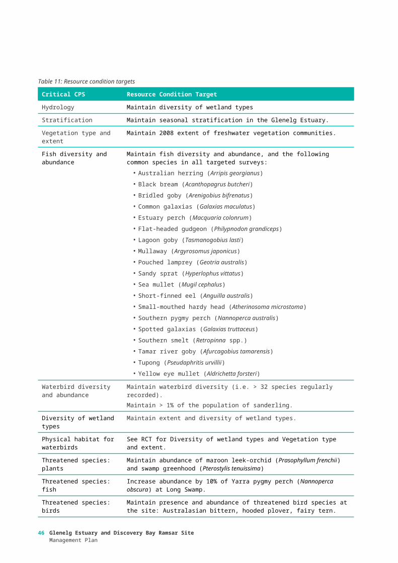
2.14 Gover
nance
Roles and responsibilities for managing Ramsar sites are set out in Wetlands in Australia – Roles and Responsibilities (http://www.environment.gov.au/water/wetlands/publications/factsheet-wetlands-australia-roles-and-responsibilities). Management of Ramsar sites in Victoria is coordinated by the Victorian Government, through the Department of Environment, Land, Water and Planning (DELWP) (see section 1.3 for relevant international, national and Victorian state policy and legislation).
2.15 Implementation
The Glenelg Hopkins CMA will co-ordinate implementation of the Glenelg RSMP, on behalf of regional agency partners. A Ramsar Coordinating Committee (RCC) comprising representatives of the partner organisations primarily responsible for the management of the Ramsar site (Glenelg Hopkins CMA, DELWP, Parks Victoria, Gunditj Mirring Traditional Owners Aboriginal Corporation and DoEE) will be convened and co-ordinated by the Glenelg Hopkins CMA. The Ramsar Steering Committee will also include local stakeholder representation.
2.15.1 Implementation planningEach of the agency delivery partners will prepare agency implementation plans for the actions for which they are identified as responsible in the Glenelg RSMP. Each agency will work within their established legislative, regulatory and administrative arrangements.
The Glenelg Hopkins CMA will integrate these agency plans into a single implementation plan for the Glenelg RSMP to ensure that the responsibilities for individual management actions are clearly established, priorities and sequencing is logical, implementation is targeted and coordinated, and funding opportunities are identified.
The plan will also establish monitoring, evaluation and reporting and improvement (MERI) requirements. The implementation plan will cover the eight-year period of this RSMP, and be regularly reviewed (in line with agency review cycles) to maintain its currency and relevance. The site MERI plan will document knowledge gaps and set out a monitoring and data collection program to fill these gaps and inform adaptive management. The MERI plan and annual action planning process will ensure that new knowledge gaps are identified as they emerge and are targeted by the site monitoring program.
2.15.2 Ramsar Coordinating Committee The RCC will be convened and co-ordinated by Glenelg Hopkins CMA. This integration approach builds on previous and current collaboration practice in the region, evident most recently in the strong participation of delivery partners in the development of the Glenelg RSMP Ngootyoong Gunditj Ngootyoong Mara South West Management Plan (Parks Victoria 2015). The RCC will be responsible for coordinating specific aspects of implementation within the themes of the RSMP. These responsibilities will include developing:
• Implementation targets;
• Action planning (including setting priorities for management), updated annually;
• Targeted investment proposals;
• Integrated delivery arrangements;
• Coordinated monitoring and evaluation of implementation, including integrated reporting against targets;
5 Governance and implementation
Glenelg Estuary and Discovery Bay Ramsar SiteManagement Plan
47

• Communication and engagement strategy; and
• Reviewing RSMP progress bi-annually.
2.15.3 Resourcing implementationInvestment proposals to support actions of the Glenelg RSMP will be developed as investment opportunities arise. Project investment proposals will be prepared through the RCC in conjunction with delivery partners, and will be structured to reflect the themes within the RSMP, and the regional programs of partner agencies.
Implementation of the Glenelg RSMP will be influenced by available funding and resources. The implementation approach that will be applied will coordinate the prioritisation of management actions so that maximum benefit is achieved with the resources that are available. Annual priorities and programs will be developed to best match the funding cycles of investors. Throughout the implementation of RSMP, the Glenelg Hopkins CMA will work with the RCC to use the best available information tools to support the establishment of annual priorities. The Glenelg Hopkins CMA will also work with the RCC to maintain the currency and accuracy of data and information to support implementation.
Implementation of the Glenelg RSMP will be influenced by available funding and resources. Partners will seek funding for implementation of this plan through the:
• Victorian Waterway Management Program;
• Relevant initiatives of the State and Federal Governments;
• Existing agency budgets; and
• Contributions of industries and communities.
2.16 Communication
The Glenelg Hopkins CMA will co-ordinate communications and engagement for the Ramsar site as part of its role in co-ordinating implementation of the Glenelg RSMP. A communication plan and engagement strategy, developed by the RCC, will guide stakeholder interactions. In particular, the communication plan will aim to include the local community (e.g. farmers, fishers, tourists, townspeople) in understanding the international values and importance of the site and how to maintain its values.
48 Glenelg Estuary and Discovery Bay Ramsar SiteManagement Plan

AS/NZS (2006). Environmental risk management – Principles and process. Standards Australia and Standards New Zealand, HB 203:2006.
Bachmann M., Whiterod N. and Farrington L. (2013). Long Swamp Fish and Frog Baseline Survey 2012. A report to the Glenelg Hopkins CMA. Aquasave Consultants – Nature Glenelg Trust.
Bamford, M. et al., (2008). Migratory shorebirds of the East Asian-Australasian flyway population estimates and internationally important sites. Available at: http://www.environment.gov.au/biodiversity/migratory/publications/shorebirds-east-asia.html [Accessed July 16, 2013].
Boon, P.I., Allen, T., Brook, J., Carr, G., Frood, D., Hoye, J., Harty, C., McMahon, A., Mathews, S., Rosengren, N.J., Sinclair, S., White, M., and Yogovic, J., 2011. Mangroves and Coastal Saltmarsh of Victoria: Distribution, Condition, Threats and Management, Melbourne: Victoria University.
Brooks, S. (2017). Boundary Description for Glenelg Estuary and Discovery Bay Ramsar Site. Report to the Glenelg Hopkins Catchment Management Authority.
Butcher, R., Hale, J., Books, S. and Cottingham, P. (2017a). Ecological Character Description for Glenelg Estuary and Discovery Bay Ramsar Site. Report to the Glenelg Hopkins Catchment Management Authority.
Butcher, R., Hale, J., Books, S. and Cottingham, P. (2017b). Ramsar Information Sheet for Glenelg Estuary and Discovery Bay Ramsar Site. Report to the Glenelg Hopkins Catchment Management Authority.
Campbell J., and Christie M. (2009). Population Status of the Little Tern (Sterna albifrons) and the Fairy Tern (S. nereis) in the lower South East of South Australia. Report to the Department of Environment and Heritage volunteer support grants program. Friends of Shorebirds SE.
Cordero-Rivera A. (2015). Demographics and adult activity of Hemiphlebia mirabilis: a short-lived species with a huge population size (Odonata: Hemiphlebiidae). Insect Conservation and Diversity:
Crowther D. (2011). The Ancient Greenling: Synthesis of new information to improve conservation outcomes. Arthur Rylah Institute for Environmental Research Department of Sustainability and Environment Heidelberg, Victoria.
Davis J. and Brock M, (2008). Detecting unacceptable change in the ecological character of Ramsar wetlands, Ecological Management and Restoration, 9(1), pp. 26-32.
DCE (1991). Lower Glenelg National Park management plan. Department of Conservation and Environment, Melbourne.
DEPI (2013). Improving Our Waterways: Victorian Waterway Management Strategy. Department of Environment and Primary Industries, Melbourne.
DEPI (2004). Discovery Bay Coastal Park East Asian-Australasian Shorebird Site Network; Site Information Sheet.
DEWHA (2009). National Framework and Guidance for Describing the Ecological Character of Australia’s Ramsar Wetlands. Module 2 of Australian National Guidelines for Ramsar Wetlands – Implementing the Ramsar Convention in Australia.
DEWHA (2008). National Framework and Guidance for Describing the Ecological Character of Australia’s Ramsar Wetlands. Module 2 of Australian National Guidelines for Ramsar Wetlands – Implementing the Ramsar Convention in Australia.
DSEWPAC (2012). Australian Ramsar Site Nomination Guidelines. Module 4 of the National Guidelines for Ramsar Wetlands—Implementing the Ramsar Convention in Australia. Australian Government Department of Sustainability, Environment, Water, Population and Communities, Canberra.
Duncan M. (2010). National Recovery Plan for the Maroon Leek-orchid Prasophyllum frenchii. Victorian Government Department of Sustainability and Environment (DSE) Melbourne.
Dickson C.R., Anderson R.A., Murphy A., Pritchard A. and Craig A. (2012). Recovery Plan for three orchid species in South Australia and Victoria: Caladenia richardsiorum (little dip spider-orchid), Caladenia calcicola (limestone spider-orchid) and Pterostylis tenuissima (swamp greenhood). Department of Environment, Water and Natural Resources, South Australia, South East Region and Department of Sustainability and Environment, Victoria, South West Victoria Region.
Ewers C., Esbert N., Hardie M., Ekanayake K., Cullen M. and Maguire G.S. (2011). Report on the 2010 Biennial Hooded Plover Count, Birds Australia.
Glenelg Hopkins CMA (2006a). Glenelg Estuary Management Plan. Glenelg Hopkins Catchment Management Authority, Hamilton.
Glenelg Hopkins CMA (2006b). Glenelg Hopkins Fishery Management Plan, Glenelg Hopkins Catchment Management Authority, Hamilton, Victoria.
References
Glenelg Estuary and Discovery Bay Ramsar SiteManagement Plan
49

Glenelg Hopkins CMA (2013). Glenelg Hopkins Regional Catchment Strategy. Glenelg Hopkins Catchment Management Authority, Hamilton.
Glenelg Hopkins CMA (2014). Glenelg Hopkins Waterway Strategy. Glenelg Hopkins Catchment Management Authority, Hamilton.
Gross J. (2003). Developing Conceptual Models for Monitoring Programs. NPS Inventory and Monitoring Program, USA.
IUCN (2012). IUCN – CMP Unified Classification of Direct Threats. Version: 3.1. Available from http://www.iucnredlist.org/documents/June_2012_Guidance_Threats_Classification_Scheme.pdf. IUCN (2015). The IUCN Red List of Threatened Species. Version 2014.3. Available from www.iucnredlist.org.
Mead R., Yarwood M., Cullen M., and Maguire G. (2012). Report on the 2012 Biennial Hooded Plover count. BirdLife.
Parks Victoria (2006). Discovery Bay Parks Management Plan. Parks Victoria, Melbourne.Parks Victoria (2015). Ngootyoong Gunditj Ngootyoong Mara South West Management Plan. Parks Victoria,
Melbourne.Phillips, B., (2006). Critique of the Framework for describing the ecological character of Ramsar Wetlands
(Department of Sustainability and Environment, Victoria, 2005) based on its application at three Ramsar sites: Ashmore Reed National Nature Reserve, the Coral Sea Reserves (Coringa-Herald and Lihou Reeds and Cays), and Elizabeth and Middleton Reeds Marine National Nature Reserve. Mainstream Environmental Consulting Pty Ltd, Waramanga ACT.
Ramsar Convention (2005). Resolution IX.1 Annex A. A Conceptual Framework for the wise use of wetlands and the maintenance of their ecological character.
Smith J., and Smith H. (2002). Little tern (Sterna albifrons) breeding season 2001/02, Glenelg River estuary, Nelson Victoria.
Smith J., and Smith H. (2001). Little tern (Sterna albifrons) breeding season 2000/01, Glenelg River estuary, Nelson Victoria.
Standards Australia and Standards New Zealand (2006). Delivering assurance based on AS/NZS 4360:2004 Risk Management, Handbook 158-2006.
Below is listed the organisations that were invited to take part in the development of the listing documents for the proposed Glenelg Estuary and Discovery Bay Ramsar Site. Not listed here are the details of the 387 adjacent landholders that were contacted and invited to take part, and the 10 community members that identified themselves as interested parties. A number of media outlets (the ABC, Border Watch, Portland Observer, Warrnambool Standard) were also provided with information on the proposed Ramsar site.
Organisation Stakeholder group
Arthur Rylah Institute of Environmental Research (DELWP) Government / Authorities
BirdLife Australia NGO
Bridgeport Energy Regional business
Bridgewater Aquatic Club Local community group
Bridgewater Coast Action Group Local community group
Commonwealth Department of Environment and Energy Government / Authorities
Country Fire Authority Government / Authorities
Dartmoor Angling Club Local community group
Deakin University Educational institution
Department of Economic Development, Jobs, Transport and Resources (DEDJTR)
Government / Authorities
Department of Environment, Land, Water and Planning Government / Authorities
Department of Environment, Water and Natural Resources (South Australia) Government / Authorities
Fisheries Victoria (DEDJTR) Government / Authorities
Appendix A: Stakeholders
50 Glenelg Estuary and Discovery Bay Ramsar SiteManagement Plan

Organisation Stakeholder group
Friends of Glenelg River Local community group
Friends of the Great South West Walk Local community group
Glenelg Hopkins Catchment Management Authority Government / Authorities
Glenelg River Cruises Local business
Glenelg River Users Group Local community group
Glenelg Shire Council Government / Authorities
Great Ocean Road Regional Tourism Regional business
Great South Coast Group Regional business
Green Triangle Forestry Products Plantation Timber Company
Gunditj Mirring TOAC Traditional Owners
Hancock Victorian Plantations Corporation Plantation Timber Company
HVP Plantations Plantation Timber Company
Nature Glenelg Trust NGO
Nelson Boat and Canoe Hire Local business
Nelson Boat Hire Local business
Nelson Coastcare Local community group
Nelson Committee of Management Local community group
Nelson Hotel Local business
Nelson Kiosk (General store) Local business
Nelson Roadhouse (BP) Local business
Nelson Visitor Information Centre Government / Authorities
Parks Victoria Government / Authorities
PF Olsen Plantation Timber Company
Portland Dune Buggy Club Local community group
Portland Field Naturalist Club NGO
Princess Margaret Rose Caves Local business
Seafood Industry Victoria NGO
SFMES Plantation Timber Company
South East Aboriginal Focus Group – Working Party Traditional Owners
Southern Rural Water Government / Authorities
Taragul Landcare Local community group
Victorian National Parks Association NGO
VR Fish NGO
Glenelg Estuary and Discovery Bay Ramsar SiteManagement Plan
51

52 Glenelg Estuary and Discovery Bay Ramsar SiteManagement Plan
Appendix B: Risk Assessment

Risk assessment for the freshwater management unit
Threats Stressors Impact pathway Likelihood of impact
Consequence of impact
Risk
Agriculture and aquaculture: Wood and pulp plantations
Decreased groundwater levels Reduced area of surface water Possible Minor Low
Agriculture and aquaculture: Wood and pulp plantations
Decreased groundwater levels Lowering of groundwater table reducing recharge to wetlands
Likely Moderate Medium
Agriculture and aquaculture: Wood and pulp plantations
Decreased groundwater levels Loss of habitat for lake bed vegetation Unlikely Minor Low
Agriculture and aquaculture: Wood and pulp plantations
Decreased groundwater levels Loss of habitat for freshwater sedge/tall marsh Likely Moderate Medium
Agriculture and aquaculture: Wood and pulp plantations
Decreased groundwater levels Reduced area and quality of drought refuge Likely Moderate Medium
Agriculture and aquaculture: Wood and pulp plantations
Decreased groundwater levels Loss of habitat available to support waterbird feeding Likely Moderate Medium
Agriculture and aquaculture: Wood and pulp plantations
Decreased groundwater levels Reduced amenity value reduced surface water and depth for water based recreation such as boating and swimming
Unlikely Moderate Low
Agriculture and aquaculture: Wood and pulp plantations
Decreased groundwater levels Reduced habitat available to support threatened plant species
Possible Moderate Medium
Agriculture and aquaculture: Wood and pulp plantations
Decreased groundwater levels Reduced habitat available to support Australasian bittern Likely Moderate Medium
Agriculture and aquaculture: Wood and pulp plantations
Decreased groundwater levels Reduced habitat available to support threatened fish species
Likely Moderate Medium
Agriculture and aquaculture: Wood and pulp plantations
Decreased groundwater levels Reduced habitat available to support Growling Grass Frog
Likely Moderate Medium
Agriculture and aquaculture: Wood and pulp plantations
Decreased groundwater levels Reduced habitat available for Ancient Greenling Likely Moderate Medium
Agriculture and aquaculture: Wood and pulp plantations
Decreased groundwater levels Loss of ecological connectivity (fish migration between freshwater units and estuary)
Likely Moderate Medium
Energy production and mining: Oil and gas drilling
Decreased groundwater levels Reduced area of surface water Rare Major Low
Glenelg Estuary and Discovery Bay Ramsar SiteManagement Plan
53

Threats Stressors Impact pathway Likelihood of impact
Consequence of impact
Risk
Energy production and mining: Oil and gas drilling
Decreased groundwater levels Lowering of groundwater table reducing recharge to wetlands
Rare Major Low
Energy production and mining: Oil and gas drilling
Decreased groundwater levels Loss of habitat for lake bed vegetation Rare Major Low
Energy production and mining: Oil and gas drilling
Decreased groundwater levels Loss of habitat for freshwater sedge/tall marsh Rare Major Low
Energy production and mining: Oil and gas drilling
Decreased groundwater levels Reduced area and quality of drought refuge Rare Major Low
Energy production and mining: Oil and gas drilling
Decreased groundwater levels Loss of habitat available to support waterbird feeding Rare Major Low
Energy production and mining: Oil and gas drilling
Decreased groundwater levels Reduced amenity value reduced surface water and depth for water based recreation such as boating and swimming
Rare Major Low
Energy production and mining: Oil and gas drilling
Decreased groundwater levels Reduced habitat available to support threatened plant species
Rare Major Low
Energy production and mining: Oil and gas drilling
Decreased groundwater levels Reduced habitat available to support Australasian bittern Rare Major Low
Energy production and mining: Oil and gas drilling
Decreased groundwater levels Reduced habitat available to support threatened fish species
Rare Major Low
Energy production and mining: Oil and gas drilling
Decreased groundwater levels Reduced habitat available to support Growling Grass Frog
Rare Major Low
Energy production and mining: Oil and gas drilling
Decreased groundwater levels Reduced habitat available for Ancient Greenling Rare Major Low
Energy production and mining: Oil and gas drilling
Decreased groundwater levels Loss of ecological connectivity (fish migration between freshwater units and estuary)
Rare Major Low
Biological resource use Recreational and commercial fishing
Increased catch reduces target fish abundance Unlikely Minor Low
Biological resource use Recreational and commercial fishing
Increased catch reduces waterbird feeding opportunities Unlikely Negligible Negligible
Biological resource use Recreational and commercial fishing
Increased catch reduces recreational fishing value Unlikely Minor Low
Biological resource use Eel harvesting Increased catch reduces Aboriginal cultural values Unlikely Minor Low
54 Glenelg Estuary and Discovery Bay Ramsar SiteManagement Plan

Threats Stressors Impact pathway Likelihood of impact
Consequence of impact
Risk
Human intrusion & disturbance Increased human presence Increased presence initiates abandonment of waterbird breeding
Unlikely Minor Low
Human intrusion & disturbance Increased noise Increased noise disrupts waterbird breeding Unlikely Minor Low
Human intrusion & disturbance Increased noise Increased noise disturbs Australasian bittern Unlikely Minor Low
Human intrusion & disturbance Physical damage (vegetation) Increased damage and degradation of lake bed vegetation
Rare Moderate Negligible
Human intrusion & disturbance Physical damage (vegetation) Increased damage and degradation of fringing vegetation Unlikely Moderate Low
Human intrusion & disturbance Physical damage (vegetation) Increased damage reduces waterbird breeding habitat availability and quality
Unlikely Moderate Low
Human intrusion & disturbance Physical damage (vegetation) Increased damage destroys threatened plant species Possible Moderate Medium
Natural systems modifications: wildfire (and/or inappropriate management)
Increased nutrients and sediments
Reduced light availability and increased algal growth adversely affects lake bed vegetation
Rare Moderate Negligible
Natural systems modifications: wildfire (and/or inappropriate management)
Increased nutrients and sediments
Reduced light availability and increased algal growth adversely affects freshwater sedge tall marsh
Rare Minor Negligible
Natural systems modifications: wildfire (and/or inappropriate management)
Increased nutrients and sediments
Increased sediment and nutrients from the catchment result in increased algal growth, decreased dissolved oxygen and impacts to fish diversity and abundance
Rare Major Low
Natural systems modifications: wildfire (and/or inappropriate management)
Increased nutrients and sediments
Increased sedimentation and nutrients from the catchment adversely affecting aquatic vegetation used in fish reproduction
Rare Major Low
Natural systems modifications: wildfire (and/or inappropriate management)
Increased nutrients and sediments
Increased sediments (abrasion, smothering) and nutrients (excessive algal growth) affects the quality of drought refuge
Rare Major Low
Natural systems modifications: wildfire (and/or inappropriate management)
Increased nutrients and sediments
Increased sedimentation and nutrients from the catchment impact physical habitat reducing opportunities for waterbird feeding
Rare Minor Negligible
Natural systems modifications: wildfire (and/or inappropriate
Increased nutrients and sediments
Increased nutrients from the catchment result in increased algal growth, decreased dissolved oxygen and
Rare Major Low
Glenelg Estuary and Discovery Bay Ramsar SiteManagement Plan
55

Threats Stressors Impact pathway Likelihood of impact
Consequence of impact
Risk
management) impacts to threatened fish species
Natural systems modifications: wildfire (and/or inappropriate management)
Loss of habitat Loss of habitat for Australasian Bittern Rare Major Low
Natural systems modifications: wildfire (and/or inappropriate management)
Loss of habitat Loss of habitat for Ancient greenling Rare Minor Negligible
Natural systems modifications: wildfire (and/or inappropriate management)
Loss of amenity Adversely effects land based recreation Possible Moderate Medium
Natural systems modifications: wildfire (and/or inappropriate management)
Increased mortality Increased mortality through direct burning of Growling grass frog
Rare Major Low
Natural systems modifications: wildfire (and/or inappropriate management)
Increased mortality Increased mortality through direct burning of threatened plant species
Rare Extreme Medium
Invasive species Non-native woody weeds (e.g. boxthorn, Mirror bush)
Increased competition displaces native freshwater sedge/tall marsh
Likely Moderate Medium
Invasive species Non-native non-woody weeds (e.g. Arum lily, buffalo grass)
Increased competition displaces native freshwater sedge/tall marsh
Likely Moderate Medium
Invasive species Non-native woody weeds (e.g. boxthorn, pine wildlings)
Increased competition displaces threatened plant species Possible Moderate Medium
Invasive species Non-native non-woody weeds (e.g. Phalaris)
Increased competition displaces threatened plant species Likely Major High
Invasive species Non-native woody weeds (e.g. boxthorn, polygala, pine wildlings)
Increased weediness affects land based recreation (visual amenity and access)
Likely Minor Medium
Invasive species Non-native terrestrial animals (pigs, foxes)
Predation affects waterbird breeding Almost certain
Moderate High
Invasive species Non-native terrestrial animals (pigs)
Increased disturbance reduces habitat quality and disturbs habitat for threatened plant species
Likely Major High
Invasive species Non-native aquatic animals Competition affects abundance of threatened fish species Possible Moderate Medium
56 Glenelg Estuary and Discovery Bay Ramsar SiteManagement Plan

Threats Stressors Impact pathway Likelihood of impact
Consequence of impact
Risk
(Gambusia)
Invasive species Non-native aquatic animals (Gambusia)
Predation affects abundance of Ancient greenling Possible Moderate Medium
Invasive species Native terrestrial weeds (coastal wattle)
Increased competition alters vegetation diversity, affecting freshwater sedge/tall marsh
Almost certain
Moderate High
Pollution: Agricultural effluents Increased nutrients Increased nutrients from the catchment result in increased algal growth, adversely affect lake bed vegetation
Rare Moderate Negligible
Pollution: Agricultural effluents Increased nutrients Increased nutrients from the catchment result in increased algal growth and impacts on habitat supporting waterbird feeding
Rare Minor Negligible
Pollution: Agricultural effluents Increased nutrients Increased nutrients from the catchment result in increased algal growth adversely affects recreation and tourism (land based via reduced visual amenity, water based by reduced water quality)
Rare Moderate Negligible
Geological events: blowouts Increased windblown sediments from exposed dunes
Increased sediments (abrasion, smothering) affects the area and quality of drought refuge
Rare Extreme Medium
Climate change and severe weather: Drought
Decreased rainfall and freshwater inflows
Reduced surface water runoff reduces wetland depth and area
Likely Major High
Climate change and severe weather: Drought
Decreased rainfall and freshwater inflows
Reduced infiltration lowers groundwater table and reduces wetland depth and area
Likely Major High
Climate change and severe weather: Drought
Decreased rainfall and freshwater inflows
Adversely effects freshwater sedge/tall marsh Likely Moderate Medium
Climate change and severe weather: Drought
Decreased rainfall and freshwater inflows
Adversely effects lake bed vegetation Rare Major Low
Climate change and severe weather: Drought
Decreased rainfall and freshwater inflows
Reduced habitat available to maintain fish diversity and abundance
Possible Moderate Medium
Climate change and severe weather: Drought
Decreased rainfall and freshwater inflows
Loss of habitat for waterbirds Possible Moderate Medium
Climate change and severe weather: Drought
Decreased rainfall and freshwater inflows
Reduced opportunity to fulfil or maintain Aboriginal cultural values
Possible Moderate Medium
Glenelg Estuary and Discovery Bay Ramsar SiteManagement Plan
57

Threats Stressors Impact pathway Likelihood of impact
Consequence of impact
Risk
Climate change and severe weather: Drought
Decreased rainfall and freshwater inflows
Reduced area and quality of drought refuge Likely Moderate Medium
Climate change and severe weather: Drought
Decreased rainfall and freshwater inflows
Reduced habitat available for threatened plant species Possible Minor Low
Climate change and severe weather: Drought
Decreased rainfall and freshwater inflows
Loss of habitat for Australasian Bittern Possible Moderate Medium
Climate change and severe weather: Drought
Decreased rainfall and freshwater inflows
Loss of habitat for Growling grass frog Possible Major High
Climate change and severe weather: Drought
Decreased rainfall and freshwater inflows
Reduced habitat available to maintain threatened fish Likely Major High
Climate change and severe weather: Drought
Decreased rainfall and freshwater inflows
Reduced habitat available to maintain Ancient Greenling Likely Major High
Climate change and severe weather: Drought
Decreased rainfall and freshwater inflows
Loss of ecological connectivity (fish migration between freshwater units and estuary)
Likely Minor Medium
58 Glenelg Estuary and Discovery Bay Ramsar SiteManagement Plan

Risk assessment for the Glenelg estuary management unit
Threats Stressors Impact pathway Likelihood of impact
Consequence of impact
Risk
Agriculture and aquaculture: Wood and pulp plantations
Decreased groundwater levels Reduced area and quality of seagrass Rare Moderate Negligible
Agriculture and aquaculture: Wood and pulp plantations
Decreased groundwater levels Reduced freshwater inputs affects estuary water quality - salinity regime
Rare Major Low
Agriculture and aquaculture: Wood and pulp plantations
Decreased groundwater levels Reduced habitat available to support fish diversity and abundance
Rare Moderate Negligible
Energy production and mining: Oil and gas drilling
Decreased groundwater levels Reduced area and quality of seagrass Rare Major Low
Energy production and mining: Oil and gas drilling
Decreased groundwater levels Reduced freshwater inputs affects estuary water quality - salinity regime
Rare Major Low
Energy production and mining: Oil and gas drilling
Decreased groundwater levels Reduced habitat available to support fish diversity and abundance
Rare Moderate Negligible
Biological resource use Recreational and commercial fishing
Increased catch reduces target fish diversity and abundance
Rare Moderate Negligible
Biological resource use Recreational and commercial fishing
Increased catch reduces value of recreational fishing Rare Minor Negligible
Biological resource use Eel harvesting Increased catch reduces Aboriginal cultural heritage Unlikely Moderate Low
Human intrusion & disturbance Increased noise Increased noise disturbs waterbird breeding Likely Moderate Medium
Human intrusion & disturbance Physical damage (vegetation) Increased damage reduces quality and extent of coastal saltmarsh
Possible Moderate Medium
Human intrusion & disturbance Physical damage (vegetation) Increased damage reduces habitat availability and quality for waterbird breeding
Rare Minor Negligible
Human intrusion & disturbance Increased litter Increased litter affects waterbird abundance Possible Minor Low
Human intrusion & disturbance Increased litter Increased litter reduces landscape and visual amenity - spiritual and inspirational
Likely Major High
Natural systems modifications: wildfire (and/or inappropriate management)
Increased nutrients and sediments
Increased sediments and nutrients and results reduced light availability and increased algal growth that reduces seagrass extent
Possible Major High
Glenelg Estuary and Discovery Bay Ramsar SiteManagement Plan
59

Threats Stressors Impact pathway Likelihood of impact
Consequence of impact
Risk
Natural systems modifications: wildfire (and/or inappropriate management)
Increased nutrients and sediments
Increased sediment and nutrients from the catchment result in increased algal growth, decreased dissolved oxygen and impacts fish diversity and abundance (including those targeted by recreational fishing)
Possible Major High
Natural systems modifications: wildfire (and/or inappropriate management)
Increased nutrients and sediments
Increased sediment and nutrients from the catchment result in increased algal growth and decreased water quality - dissolved oxygen
Possible Minor Low
Natural systems modifications: wildfire (and/or inappropriate management)
Increased nutrients and sediments
Increased sediment and nutrients from the catchment result in increased algal growth, decreased dissolved oxygen and impacts fish migration (including those targeted by recreational fishing)
Possible Minor Low
Natural systems modifications: wildfire (and/or inappropriate management)
Increased nutrients and sediments
Increased sediment and nutrients from the catchment result in increased algal growth, decreased dissolved oxygen and impacts fish reproduction (including those targeted by recreational fishing)
Possible Minor Low
Natural systems modification: water resource use
Decreased freshwater inflows Decreased inflows alters surface water regime and the frequency of opening and closing of the estuary mouth
Likely Major High
Natural systems modification: water resource use
Decreased freshwater inflows Decreased inflows alters the groundwater regime and the frequency of opening and closing of the estuary mouth
Possible Major High
Natural systems modification: water resource use
Decreased freshwater inflows Reduced inflows alter the salinity regime, which affects fish diversity and abundance
Possible Moderate Medium
Natural systems modification: water resource use
Decreased freshwater inflows Decreased inflows alters estuary water quality - salinity regime
Likely Moderate Medium
Natural systems modification: water resource use
Decreased freshwater inflows Decreased inflows alters estuary water regime - intermittently opening and closing estuary
Almost certain
Moderate High
Natural systems modification: water resource use
Decreased freshwater inflows Altered salinity regime reduces opportunity to fulfil or maintain Aboriginal cultural heritage
Possible Moderate Medium
Natural systems modification: water resource use
Decreased freshwater inflows Hydrological processes support wetland type and extent Possible major High
Natural systems modification: water resource use
Decreased freshwater inflows Decreased inflows reduces ecological connectivity for fish migration
Likely Minor Medium
Invasive species Non-native woody weeds (Italian buckthorn, boxthorn,
Increased competition displaces native plant species and affects landscape and visual amenity - spiritual and
Almost minor Medium
60 Glenelg Estuary and Discovery Bay Ramsar SiteManagement Plan

Threats Stressors Impact pathway Likelihood of impact
Consequence of impact
Risk
polygala, pine wildlings) inspirational certain
Invasive species Non-native non-woody weeds (e.g. bridal creeper, blue bell creeper, ivy spp. Juncus acutus)
Increased competition displaces native species and communities and reduces quality of riparian vegetation.
Possible Moderate Medium
Invasive species Non-native woody weeds (Italian buckthorn, boxthorn, polygala, pine wildlings) woody vegetation species
Increased competition displaces native species and communities in riparian vegetation
Almost certain
Moderate High
Invasive species Non-native non-woody weeds (e.g. Sicilian sea lavender)
Increased competition displaces native species affecting extent and quality of coastal saltmarsh community.
Possible Extreme High
Invasive species Non-native weeds (Italian buckthorn, boxthorn, polygala, pine wildlings) woody plants
Increased competition displaces native plant species and affects landscape and visual amenity, recreation and tourism - land based activities
Rare Minor Negligible
Invasive species Native terrestrial weeds (coastal wattle)
Increased competition alters vegetation diversity, affecting dune scrub
Possible Major High
Invasive species Non-native terrestrial animals (foxes, cats, pigs)
Predation and disturbance affects waterbird breeding Almost certain
Moderate High
Invasive species Non-native aquatic animals - carp
Altered habitat reducing fish diversity and abundance Possible Major High
Invasive species Non-native aquatic animals - gambusia, goldfish, red fin, trout
Increased competition reducing fish abundance and diversity
Rare Minor Negligible
Invasive species Problematic native species - Australian bass, Catfish Tandanus tandanus, Murray cod, Yellow belly/Callop Macquaria ambigua
Increased competition reducing fish abundance and diversity
Rare Minor Negligible
Pollution: Agricultural effluents Increased nutrients Increased nutrients from the catchment result in increased epiphytic algal growth, impacting on seagrass
Unlikely Moderate Low
Pollution: Agricultural effluents Increased nutrients Increased nutrients from the catchment result in increased algal growth and affects recreation and tourism - water based activities
Possible Minor Low
Glenelg Estuary and Discovery Bay Ramsar SiteManagement Plan
61

Threats Stressors Impact pathway Likelihood of impact
Consequence of impact
Risk
Pollution: Agricultural effluents Increased sediments Reduced light affects seagrass Unlikely Major Medium
Pollution: Agricultural effluents Increased sediments Reduced habitat diversity affects fish diversity and abundance
Possible Moderate Medium
Pollution: Industrial and military effluents
Increased toxicants from mine seepage
Increased toxicity reduces coastal saltmarsh extent Rare minor Negligible
Pollution: Industrial and military effluents
Increased toxicants from mine seepage
Reduced area and quality of seagrass Rare Major Low
Pollution: Industrial and military effluents
Increased toxicants from mine seepage
Increased toxicity reduces fish diversity and abundance Rare Major Low
Climate change and severe weather: seas level rise
Increased ingress of marine water
Increased marine water inputs alters coastal saltmarsh extent
Possible Minor Low
Climate change and severe weather: seas level rise
Increased ingress of marine water
Increase salinity (or change in salinity regime) affects fish diversity, especially the breeding of estuarine specialists that includes important recreational fishing species
Possible Negligible Negligible
Climate change and severe weather: seas level rise
Increased ingress of marine water
Increased sea level affects surface water regime and changes character from an intermittently opening and closing estuary
Unlikely Major Medium
Climate change and severe weather: seas level rise
Decreased access Decreased access reduces the value of the estuary for recreation and tourism - water based activities
Unlikely Major Medium
Climate change and severe weather: seas level rise
Decreased access Decreased access reduces the value of the estuary in terms of Aboriginal cultural heritage
Unlikely Minor Low
Climate change and severe weather: Drought
Decreased rainfall and freshwater inflows
Decreased inflows alter the surface water regime and the frequency of opening and closing of the estuary mouth
Likely Moderate Medium
Climate change and severe weather: Drought
Decreased rainfall and freshwater inflows
Reduced inflows alter the salinity regime, which affects fish diversity and abundance
Possible Moderate Medium
Climate change and severe weather: Drought
Decreased rainfall and freshwater inflows
Decreased inflows alters estuary water quality - salinity regime
Likely Major High
Climate change and severe weather: Drought
Decreased rainfall and freshwater inflows
Altered salinity regime reduces opportunity to fulfil or maintain Aboriginal cultural values
Possible Moderate Medium
Climate change and severe weather: Strom and flooding (increased
Increased deposition of marine sediments
Alters pattern of opening and closing of the estuary mouth
Possible Minor Low
62 Glenelg Estuary and Discovery Bay Ramsar SiteManagement Plan

Threats Stressors Impact pathway Likelihood of impact
Consequence of impact
Risk
extreme events)
Climate change and severe weather: Strom and flooding (increased extreme events)
Increased erosion of beach sediments
Altered beach profile Possible Minor Low
Glenelg Estuary and Discovery Bay Ramsar SiteManagement Plan
63

Risk assessment for the Beach and Dune fields management unit
Threats Stressors Impact pathway Likelihood of impact
Consequence of impact
Risk
Agriculture: Wood and pulp plantations Decreased groundwater levels Altered groundwater interactions affecting hydrological processes which support dune slack wetlands
Unlikely Major Medium
Biological resource use Recreational and commercial fishing - fin fishing
Increased catch reduces food source for migratory birds
Unlikely Minor Low
Biological resource use Recreational and commercial fishing - fin fishing
Increased catch reduces food source that supports waterbird breeding
Unlikely Minor Low
Biological resource use Pipi harvesting Increased catch reduces food source for migratory birds
Possible Moderate Medium
Biological resource use Pipi harvesting Increased catch reduces food source that supports waterbird breeding
Possible Moderate Medium
Human intrusion & disturbance Increased noise Increased noise disturbs waterbird breeding Possible Minor Low
Human intrusion & disturbance Increased noise Increased noise disturbs migratory birds Possible Minor Low
Human intrusion & disturbance Physical damage - nesting areas Increased visitations disrupt waterbird breeding through physical damage to nesting sites
Possible Minor Low
Human intrusion & disturbance Increased physical damage Increased visitation damages sensitive Aboriginal cultural sites
Possible Minor Low
Natural systems modifications: fire Decreased vegetation cover Decreased vegetation cover affects erosion and exposure of Aboriginal significance sites
Possible Moderate Medium
Natural systems modifications: fire Decreased vegetation cover Decreased vegetation cover reduces dune stability, affecting the area and distribution of dune slack wetlands
Unlikely Extreme Medium
Natural systems modifications: fire Decreased vegetation cover Decreased vegetation cover leads to reduced aesthetic values
Possible Moderate Medium
Natural systems modifications: fire Decreased vegetation cover Decreased vegetation cover reduces dune vegetation extent and diversity
Possible Major High
Natural systems modifications: fire Decreased vegetation cover Decreased vegetation cover reduces dune stability
Unlikely Major Medium
64 Glenelg Estuary and Discovery Bay Ramsar SiteManagement Plan

Threats Stressors Impact pathway Likelihood of impact
Consequence of impact
Risk
Invasive species Non-native woody weeds (e.g. boxthorn, polygala)
Increased competition displaces native dune scrub vegetation
Likely Moderate Medium
Invasive species Non-native weeds (e.g. Marram grass, Sicilian sea lavender)
Increased competition displaces native dune scrub vegetation
Likely Moderate Medium
Invasive species Non-native terrestrial animals (e.g. foxes, cats)
Increased predation affects waterbird breeding Likely Moderate Medium
Invasive species Native terrestrial animals (e.g. ravens)
Increased predation affects waterbird breeding Likely Moderate Medium
Invasive species Non-native terrestrial animals (e.g. foxes, cats)
Increased predation affects migratory birds Likely Moderate Medium
Invasive species Native terrestrial animals (e.g. ravens)
Increased predation affects migratory birds Likely Moderate Medium
Invasive species Native species (e.g. coastal wattle)
Increased competition alters vegetation diversity, affecting dune scrub
Likely Major High
Pollution: garbage and solid waste Increased marine pollution and litter
Increased marine pollution and litter affects landscape aesthetics (land based recreation)
Almost certain Moderate High
Pollution: garbage and solid waste Increased marine pollution and litter
Increased marine pollution and litter affects habitat quality for waterbird feeding
Possible Minor Low
Climate change and severe weather: seas level rise
Increase ingress of marine water Increased sea level leads to loss of beach profile and reduced area for waterbird breeding
Possible Major High
Climate change and severe weather: seas level rise
Increased ingress of marine water Loss of beach profile and access affects land based recreation opportunities
Unlikely Minor Low
Climate change and severe weather: seas level rise
Increased ingress of marine water Loss of beach profile reduces habitat available for migratory birds
Possible Major High
Climate change and severe weather: extreme storm events
Increased beach and erosion Increased in large storm frequency and erosion leads to loss of beach profile and reduced area for waterbird breeding
Possible Major High
Climate change and severe weather: extreme storm events
Increased beach erosion Increased erosion leads to reduced primary dune stability and increased chances of blowouts
Unlikely Major Medium
Climate change and severe weather: Increased beach erosion Loss of beach profile leads to reduced Possible Major High
Glenelg Estuary and Discovery Bay Ramsar SiteManagement Plan
65

Threats Stressors Impact pathway Likelihood of impact
Consequence of impact
Risk
extreme storm events waterbird feeding habitat
66 Glenelg Estuary and Discovery Bay Ramsar SiteManagement Plan

Glenelg Estuary and Discovery Bay Ramsar SiteManagement Plan
67

Prioritisation of values for each of the three management units was derived by applying the criteria in Table 14. Scores for Values Criterion 1 were based on whether or not a value was a critical CPS. Scores for Criterion 2 were based on inclusion in existing management plans and strategies. Scores for Criterion 3 were based on community priorities (from stakeholder workshops), while Criterion 4 scores were derived from the risk ratings in Appendix A.
Table 14: Criteria for prioritisation of values (and descriptions of low (1), medium (2) and high (3) rankings).
Criteria Description Score
1. Critical to the ecological character of the Glenelg Estuary and Discovery Bay Ramsar Site
Low priority: Not identified as either a critical or supporting CPS, but occurs within the management unit.
1
Medium priority: Value relates to a supporting CPS identified in the ECD. 2
High priority: Value is a critical component, process or service/benefit and present in the management unit.
3
2. Management priority Low priority: Not currently identified as a management priority. 1
Medium priority: Value relates to one or more state listed and/or one or more items listed under international agreements; regional management priority included in regional planning frameworks, management plans etc. Management may be only partially implemented, and possibly not within the management unit.
2
High priority: Value relates to one or more matters of National Environmental Significance under the Environment Protection and Biodiversity Conservation Act (EPBC), or other national planning instrument, may or may not include state listed or internationally listed taxa.
3
3. Community priority Low priority: Value identified as a low priority by general community. 1
Medium priority: Value identified as of moderate priority for the community. 2
High priority: Value identified as a high priority by the community 3
4. Risk (from risk assessment)
Low priority: No high or extreme risks identified for the value. 1
Medium priority: One high risk identified for the value. 2
High priority: An “extreme” risk and / or two or more “high” risks identified for the value.
3
Appendix C: Prioritisation of values
68 Glenelg Estuary and Discovery Bay Ramsar SiteManagement Plan
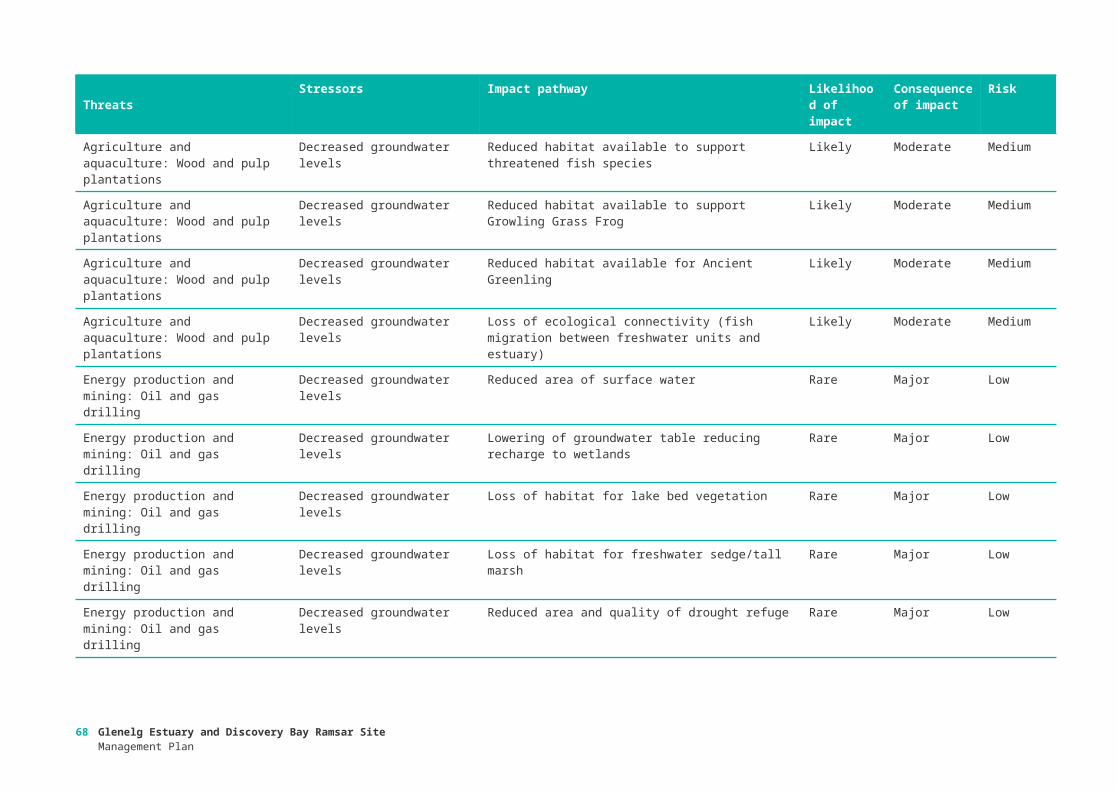
Table 15: Values prioritisation – Freshwater wetlands management unit. Green shaded values = High priority, grey shaded values = Medium priority, orange shaded values = Low priority. Values marked as NA did not occur at this management unit.
Values C1 C2 C3 C4 Total CommentsVegetation: Freshwater sedge/tall marsh 3 3 3 2 11Threatened species: Maroon Leek-orchid and swamp greenhood 3 3 2 3 11
Threatened Species: Yarra pygmy perch 3 3 3 2 11Threatened Species: Growling grass frog 3 3 3 2 11Threatened Species: Ancient greenling 3 3 3 2 11Hydrology: Groundwater regime 3 2 3 2 10Hydrology: Surface water regime 3 2 2 3 10Fish diversity and abundance 3 3 3 1 10Vegetation: Lake bed vegetation 3 2 3 1 9Hydrological process that support wetland type and extent
3 2 1 3 9
Score of 3 for Criterion 4 reflects combination of previous scores for groundwater and surface water (Cascade effect)
Threatened Species: Australasian Bittern 3 3 2 1 9Waterbird diversity and abundance 3 2 2 1 8Water quality: Salinity regime 3 2 2 1 8Waterbird breeding 3 2 1 2 8Spiritual and inspirational
3 3 1 1 8
Criterion 2 = 3, recognising listing on the National Estate, classification by the National Trust Australia, and Heritage River listing.
Supports special geomorphic feature: Dune slack wetlands 3 3 1 1 8
Fish migration 3 2 1 1 7Fish reproduction 3 2 1 1 7Intermittently opening and closing estuary 3 2 1 1 7Primary dune stability 3 2 1 1 7Provision of food (recreational fishing) 3 2 1 1 7Aboriginal cultural heritage
3 2 1 1 7
Recreation and tourism: Water based activities (swimming, boating) 3 2 1 1 7
Recreation and tourism: Land based activities (camping, bushwalking, nature observation) 3 2 1 1 7
Supports special geomorphic feature: drought refuge 3 2 1 1 7
Provision of physical habitat for waterbirds (feeding) 3 2 1 1 7
Ecological connectivity (for fish migration) 3 1 1 1 6Large size (physical extent) 2 1 1 1 5Low impact development 1 1 1 1 4
Glenelg Estuary and Discovery Bay Ramsar SiteManagement Plan
69

Values C1 C2 C3 C4 Total CommentsVegetation: Dune scrub 0 0 0 0 0 NAVegetation: Coastal saltmarsh 0 0 0 0 0 NAVegetation: Seagrass 0 0 0 0 0 NABeach profile 0 0 0 0 0 NAWater quality - Dissolved oxygen 0 0 0 0 0 NAProvision of food (commercial fishing (black bream, eels)) 0 0 0 0 0 NA
Threatened Community: Subtropical and temperate coastal saltmarsh 0 0 0 0 0 NA
Threatened Species: Fairy tern 0 0 0 0 0 NAThreatened Species: Hooded plover 0 0 0 0 0 NASupports priority wetland species: Migratory waterbirds 0 0 0 0 0 NA
Table 16: Values prioritisation – Glenelg Estuary management unit. Green shaded values = High priority, grey shaded values = Medium priority, orange shaded values = Low priority. Values marked as NA did not occur at this management unit.
Values C1 C2 C3 C4 Total Comments
Fish diversity and abundance 3 3 3 3 12
Hydrology: Surface water regime 3 2 3 2 10
Hydrology: Groundwater regime 3 2 3 2 10
Vegetation: Coastal saltmarsh 3 3 2 2 10
Hydrological process that support wetland type and extent 2 2 3 3 10
Criterion 4 = 3, representing combined threats to groundwater and surface water
Threatened Community: Subtropical and temperate coastal saltmarsh 3 3 2 2 10
Water quality: Salinity regime 3 2 2 2 9
Intermittently opening and closing estuary 2 2 3 2 9
Provision of food: Recreational fishing 3 2 3 1 9
Recreation and tourism: Water based activities (swimming, boating) 3 2 3 1 9
Recreation and tourism: Land based activities (camping, bushwalking, nature observation)
3 2 3 1 9
Vegetation: Seagrass 3 1 2 2 8
Water quality - dissolved oxygen 3 2 2 1 8
Waterbird breeding 3 2 1 2 8
Spiritual and inspirational 3 2 1 2 8
Waterbird diversity and abundance 3 2 1 1 7
Fish reproduction 3 2 1 1 7
70 Glenelg Estuary and Discovery Bay Ramsar SiteManagement Plan

Values C1 C2 C3 C4 Total Comments
Provision of food (commercial fishing (black bream, eels)) 3 2 1 1 7
Aboriginal cultural heritage 3 2 1 1 7
Supports special geomorphic feature: drought refuge 3 2 1 1 7
Provision of physical habitat for waterbirds (feeding) 3 2 1 1 7
Ecological connectivity (for fish migration) 3 2 1 1 7
Beach profile 3 1 1 1 6
Fish migration 2 2 1 1 6
Vegetation: Dune scrub 0 0 0 0 0 NA
Vegetation: Freshwater sedge/tall marsh 0 0 0 0 0 NA
Vegetation: Lake bed vegetation 0 0 0 0 0 NA
Primary dune stability 0 0 0 0 0 NA
Supports special geomorphic feature: Dune slack wetlands 0 0 0 0 0 NA
Threatened species: Maroon leek-orchid and swamp greenhood 0 0 0 0 0 NA
Threatened Species: Australasian bittern 0 0 0 0 0 NA
Threatened Species: Fairy tern 0 0 0 0 0 NA
Threatened Species: Hooded plover 0 0 0 0 0 NA
Threatened Species: Yarra pygmy perch 0 0 0 0 0 NA
Threatened Species: Growling grass frog 0 0 0 0 0 NA
Threatened Species: Ancient greenling 0 0 0 0 0 NA
Supports priority wetland species: Migratory waterbirds 0 0 0 0 0 NA
Fish diversity and abundance 3 3 3 3 12
Table 17: Values prioritisation – Beach and dune fields management unit. Green shaded values = High priority, grey shaded values = Medium priority, orange shaded values = Low priority. Values marked as NA did not occur at this management unit.
Values C1 C2 C3 C4 Total CommentsThreatened Species: Fairy tern 3 3 2 3 11
Threatened Species: Hooded plover3 3 2 3 11
Supports priority wetland species: Migratory waterbirds 3 3 3 2 11Vegetation: Dune scrub 3 2 2 3 10Waterbird breeding 3 2 2 3 10Recreation and tourism: Land based activities (camping, bushwalking, nature observation) 3 2 2 2 9Spiritual and inspirational 3 2 3 1 9Waterbird diversity and abundance 3 2 2 1 8
Glenelg Estuary and Discovery Bay Ramsar SiteManagement Plan
71

Values C1 C2 C3 C4 Total CommentsPrimary dune stability 2 2 3 1 8Provision of food: Recreational fishing 3 2 2 1 8Aboriginal cultural heritage 3 2 2 1 8Hydrology: Groundwater regime 3 2 1 1 7Provision of food (commercial fishing (black bream, eels)) 3 2 1 1 7Recreation and tourism: Water based activities (swimming, boating) 3 2 1 1 7Provision of physical habitat for waterbirds (feeding) 2 2 1 2 7Hydrological process that support wetland type and extent 2 2 1 1 6Supports special geomorphic feature: Dune slack wetlands 2 1 2 1 6Protection from development 1 2 1 1 5Beach profile 1 1 1 1 4Hydrology: Surface water regime 0 0 0 0 0 NAVegetation: Coastal saltmarsh 0 0 0 0 0 NAVegetation: Freshwater sedge/tall marsh 0 0 0 0 0 NAVegetation: Lake bed vegetation 0 0 0 0 0 NAVegetation: Seagrass 0 0 0 0 0 NAFish diversity and abundance 0 0 0 0 0 NAWater quality: Salinity regime 0 0 0 0 0 NAWater quality - Dissolved oxygen 0 0 0 0 0 NAFish migration 0 0 0 0 0 NAFish reproduction 0 0 0 0 0 NAIntermittently opening and closing estuary 0 0 0 0 0 NASupports special geomorphic feature: drought refuge 0 0 0 0 0 NA
Threatened Community: Subtropical and temperate coastal saltmarsh 0 0 0 0 0 NA
Threatened species: Maroon leek-orchid and swamp greenhood 0 0 0 0 0 NA
Threatened Species: Australasian bittern 0 0 0 0 0 NAThreatened Species: Yarra pygmy perch 0 0 0 0 0 NAThreatened Species: Growling grass frog 0 0 0 0 0 NAThreatened Species: Ancient greenling 0 0 0 0 0 NAEcological connectivity (for fish migration) 0 0 0 0 0 NA
72 Glenelg Estuary and Discovery Bay Ramsar SiteManagement Plan

Threats were prioritised according to the criteria provided in Table 18. Threat Criterion 1 scores were derived from the risk ratings in Appendix 1. Scores for Criteria 2 and 3 were derived from information on management feasibility and cost provided by Parks Victoria and the Glenelg Hopkins CMA, based on their existing management priorities and program costs.
Threat criteria were each summed (for each of the four criteria) and ranked as High, Medium or Low priority:
High ≥10,
Medium 7-9,
Low <7.
Table 18: Criteria for prioritisation of threats (and descriptions of low (1), medium (2) and high (3) rankings).
Criteria Description Score
1. Identified as a significant risk to the ecological character of the site
Low priority: Risk assessment identified no high risks associated with the threatening activity
1
Medium priority: Risk assessment identified one high risk associated with the threatening activity
2
High priority: Risk assessment identified two or more high risks and / or an extreme risk associated with the threatening activity
3
2. Management intervention feasible or a current management focus
No active management: Actions will not address the threatening activity nor measurably mitigate the impact.
1
Some active management: Management activities in the site or catchment may address threat but are not likely to result in a significant and sustained effect on ecological character.
2
Actively managed: Threatening activity able to be addressed or mitigation of impact is possible through active management.
3
3. Cost High cost: Capital costs and / or ongoing costs are high. 1
Moderate cost: Moderate capital cost and / or moderate ongoing cost of implementation.
2
Low cost: Low capital cost and ongoing cost of implementing the option. 3
4. Community priority
Low priority: Not identified of concern by general community. 1
Medium priority: Threat identified as of moderate interest/concern for the community.
2
High priority: Threat identified as a high priority by the community 3
Appendix D: Prioritisation of threats
Glenelg Estuary and Discovery Bay Ramsar SiteManagement Plan
73

Table 19: Threat prioritisation – Freshwater wetland management unit. Orange shaded values = High priority, grey shaded values = Medium priority, green shaded values = Low priority. Values marked as NA did not occur at this management unit.
Threats Stressors C1 C2 C3 C4 Total
Invasive species Non-native non-woody weeds (e.g. Phalaris) 3 2 3 3 11
Invasive species Native terrestrial weeds (coastal wattle) 3 2 3 3 11
Energy production and mining: oil and gas drilling
Decreased groundwater levels1 3 3 3 10
Invasive species Non-native woody weeds (e.g. boxthorn, pine wildlings) 2 2 3 3 10
Invasive species Non-native terrestrial animals (pigs, foxes) 3 2 3 2 10
Climate change and severe weather: Drought
Decreased rainfall and freshwater inflows 3 1 3 3 10
Human intrusion & disturbance Physical damage (vegetation) 2 2 3 2 9Invasive species Non-native aquatic animals
(Gambusia) 2 2 3 2 9
Agriculture: Wood and pulp plantations
Decreased groundwater levels2 1 3 2 8
Human intrusion & disturbance Increased human presence 1 2 3 2 8Human intrusion & disturbance Increased noise 1 2 3 2 8Natural systems modifications: fire
Loss of amenity2 2 2 2 8
Natural systems modifications: fire
Increased mortality2 2 2 2 8
Biological resource use Recreational and commercial fishing 1 2 3 1 7
Natural systems modifications: fire
Increased nutrients and sediments 1 2 2 2 7
Natural systems modifications: fire
Loss of habitat1 2 2 2 7
Pollution: Agricultural effluents Increased nutrients 1 1 3 2 7Geological events: blowouts Increased windblown
sediments from exposed dunes 2 1 2 1 6
74 Glenelg Estuary and Discovery Bay Ramsar SiteManagement Plan

Table 20: Threat prioritisation – Glenelg Estuary management unit. Orange shaded values = High priority, grey shaded values = Medium priority, green shaded values = Low priority. Values marked as NA did not occur at this management unit.
Threats Stressors C1 C2 C3 C4 Total
Natural system modification Other ecosystem modifications (e.g. opening the mouth of the estuary, previous land clearing and snag removal)
3 3 3 3 12
Natural systems modification: water resource use
Decreased freshwater inflows 3 2 3 3 11
Invasive species Non-native woody weeds (Italian buckthorn, boxthorn, polygala, pine wildlings) 3 2 3 3 11
Invasive species Non-native non-woody weeds (e.g. Sicilian sea lavender) 3 2 3 3 11
Invasive species Native terrestrial weeds (coastal wattle) 3 2 3 3 11Invasive species Non-native terrestrial animals (foxes, cats,
pigs) 3 2 3 3 11
Invasive species Non-native aquatic animals - carp 3 2 3 3 11Natural systems modifications: wildfire (and/or inappropriate management)
Increased nutrients and sediments3 3 2 2 10
Energy production and mining: Oil and gas drilling
Decreased groundwater levels1 3 3 2 9
Human intrusion & disturbance Increased litter 3 2 3 1 9Invasive species Problematic native species - Australian bass,
catfish Tandanus, Murray cod, yellow belly/Callop Macquaria ambigua
1 2 3 3 9
Climate change and severe weather: Drought
Decreased rainfall and freshwater inflows 3 1 3 2 9
Human intrusion & disturbance Increased noise 2 2 3 1 8Human intrusion & disturbance Physical damage (vegetation) 2 2 3 1 8Pollution: Garbage and solid waste Marine pollution and litter 1 2 3 2 8Climate change and severe weather: Seas level rise
Increased ingress of marine water 2 1 3 2 8
Biological resource use Commercial and recreational fishing 1 2 3 1 7
Pollution: Agricultural effluents Increased sediments 2 1 3 1 7Pollution: Industrial and military effluents
Increased toxicants from mine seepage1 1 3 2 7
Climate change and severe weather: Sea level rise
Increased ingress of marine water1 1 3 2 7
Climate change and severe weather: Sea level rise
Decreased access2 1 3 1 7
Climate change and severe weather: Strom and flooding (increased extreme events)
Increased erosion of beach sediments1 1 3 2 7
Agriculture and aquaculture: Wood and pulp plantations
Decreased groundwater levels 1 1 3 1 6
Pollution: Agricultural effluents Increased nutrients 1 1 3 1 6Pollution: Household sewage and urban wastewater
Increased nutrients 1 1 2 1 5
Glenelg Estuary and Discovery Bay Ramsar SiteManagement Plan
75

Table 21: Threat prioritisation – Beach and dune field management unit. Orange shaded values = High priority, grey shaded values = Medium priority, green shaded values = Low priority. Values marked as NA did not occur at this management unit.
Threats Stressors C1 C2 C3 C4 Total
Invasive species Native species (e.g. coastal wattle) 3 2 3 3 11Invasive species Non-native woody weeds (e.g. boxthorn, polygala) 2 2 3 3 10Invasive species Non-native weeds (e.g. Marram grass, Sicilian sea
lavender) 2 2 3 3 10
Climate change and severe weather: Sea level rise
Increase ingress of marine water 3 1 3 3 10
Climate change and severe weather: Extreme storm events
Increased beach erosion 3 1 3 3 10
Invasive species Non-native terrestrial animals (e.g. foxes, cats) 2 2 3 2 9Invasive species Native terrestrial animals (e.g. ravens) 2 2 3 2 9Pollution: Garbage and solid waste
Increased marine pollution and litter 3 2 3 1 9
Climate change and severe weather: Extreme storm events
Increased beach erosion 2 1 3 3 9
Climate change and severe weather: Sea level rise
Increased ingress of marine water 1 1 3 3 8
Agriculture: Wood and pulp plantations
Decreased groundwater levels 2 1 3 1 7
Biological resource use Pipi harvesting 2 2 3 7Human intrusion & disturbance Increased physical damage 2 2 3 7Natural systems modifications: Fire
Decreased vegetation cover 3 2 2 7
Pollution: Garbage and solid waste
Increased marine pollution and litter 1 2 3 1 7
Human intrusion & disturbance Increased noise 1 2 3 6Natural systems modifications: fire
Decreased vegetation cover 2 2 2 6
Biological resource use Recreational and commercial fishing - fin fishing 1 1 3 5
76 Glenelg Estuary and Discovery Bay Ramsar SiteManagement Plan

Critical CPS Baseline / supporting evidence Limit of Acceptable Change Resource Condition Target
Hydrology With the exception of the Glenelg Estuary, quantitative information on the hydrological regimes of most of the wetlands in the Ramsar site is lacking. For the inland wetlands, a change in permanence (e.g. permanent to intermittent) would be considered a change in character. Permanent wetlands within the site comprise: Bridgewater Lakes, Lake Moniboeng, Swan Lake, Malseed Lake and Cain Flat Swamp.There is insufficient data to derive a hydrological LAC for the other wetlands in the site.The Glenelg Estuary is seasonally closed estuary that is characterised by periods of closure averaging 40 days, but sometimes spanning a year. A sustained change to become permanently open or closed would represent a potential change in character.
Bridgewater Lakes, Lake Moniboeng, Swan Lake, Malseed Lake and Cain Flat Swamp will not dry.
The Glenelg Estuary will not remain closed for three consecutive years or open for greater than five years.
Maintain diversity of wetland types
Stratification The Glenelg Estuary is a seasonally closed salt-wedge estuary with three distinct layers that vary under different tidal and freshwater inflow conditions. Maintaining this variability in salinity and dissolved oxygen regimes is important for many biological and chemical functions and processes. The variability is maintained by the opening and closing of the estuary mouth.
See LAC for hydrology (Glenelg Estuary) Maintain seasonal stratification in the Glenelg Estuary.
Vegetation type and extent
Two broad vegetation types in the site were mapped in detail in 2008 (Sinclair and Sutter 2008):
• Coastal saltmarsh - 26 hectares
• Freshwater sedges and tall marsh - 939 hectares
A LAC has been set based on a 50% change in extent (consistent with LAC for other Victorian Ramsar sites).Lake bed macrophytes are also a critical component of the ecological character of the site, but remain a knowledge gap with insufficient information to derive a LAC for this community.
Vegetation extent will not fall below the following:
• Coastal saltmarsh - 13 hectares
• Freshwater sedges and tall marsh - 470 hectares, with at least 270 hectares of Baumea sedgelands.
Maintain 2008 extent of freshwater vegetation communities.
Appendix E: Resource Condition Targets
Glenelg Estuary and Discovery Bay Ramsar SiteManagement Plan
77

Critical CPS Baseline / supporting evidence Limit of Acceptable Change Resource Condition Target
Fish diversity and abundance
There is a lack of underlying knowledge of variability in fish species richness for the site, with incomplete inventory of several of the freshwater wetlands. Current species lists put the number of species found at the site at 45 across four life history strategies (i.e. freshwater, estuarine, diadromous and marine – based on Potter et al. 2015).The LAC has been developed based on expert opinion and due to the limited data focuses on the loss of a guild as representing a potential change in character.
Native fish within the Ramsar site will represent each of the following life history strategies: estuarine dependent, estuarine opportunists, marine migrants, diadromous and obligate freshwater species.
Maintain fish diversity and abundance, and the following common species in all targeted surveys:Australian herring (Arripis georgianus)Black bream (Acanthopagrus butcheri)Bridled goby (Arenigobius bifrenatus)Common galaxias (Galaxias maculatus)Estuary perch (Macquaria colonrum)Flat-headed gudgeon (Philypnodon grandiceps)Lagoon goby (Tasmanogobius lasti)Mullaway (Argyrosomus japonicus)Pouched lamprey (Geotria australis)Sandy sprat (Hyperlophus vittatus)Sea mullet (Mugil cephalus)Short-finned eel (Anguilla australis)Small-mouthed hardy head (Atherinosoma microstoma)Southern pygmy perch (Nannoperca australis)Spotted galaxias (Galaxias truttaceus)Southern smelt (Retropinna spp.)Tamar river goby (Afurcagobius tamarensis)Tupong (Pseudaphritis urvillii)Yellow eye mullet (Aldrichetta forsteri)
Waterbird diversity and abundance
The site supports a diversity of waterbirds with a total of 95 wetland dependent species recorded from the site. Consistent count data are not available, but BirdLife Australia records indicate that 32 species across several waterbird guilds are regularly recorded (> two thirds of years) in the site:
• Ducks, swans and grebes
Absence of the following waterbird guilds in any three out of five years:
• Ducks, swans and grebes
• Fishers
• Large wading birds
• Australian waders
Maintain waterbird diversity (i.e. > 32 species regularly recorded).Maintain > 1% of the population of sanderling.
78 Glenelg Estuary and Discovery Bay Ramsar SiteManagement Plan

Critical CPS Baseline / supporting evidence Limit of Acceptable Change Resource Condition Target
• Fishers
• Large wading birds
• Australian waders
• International waders
• Gulls and terns
• In addition, the site supports 1.4 % of the population of sanderling (Calidris alba).
The LAC is based on representative waterbird guilds and a 50% decline in the Sanderling.
• International waders
• Gulls and terns
• Sanderling abundance falls below 0.7% of the global population in three out of five years.
Diversity of wetland types
The Glenelg Estuary Ramsar site supports a range of wetland types. Wetland type is a product of hydrology and vegetation. This criteria service is covered by the LACs for those respective components and processes.
See LAC for vegetation type and extent and hydrology.
Maintain extent and diversity of wetland types.
Special geomorphic features: dune slack
The formation of dune slack wetlands is a critical feature of the site and contributes to meeting criterion 1 however this service does not lend itself to having a threshold of change as it operates on geological time scales.
No LAC
Physical habitat for waterbirds
This critical service is linked to changes in the frequency and duration of wetland inundation as well as changes in extent and condition of vegetation.
See LAC for vegetation type and extent and hydrology.
See RCT for Diversity of wetland types and Vegetation type and extent.
Threatened species: plants
Two nationally threatened plant species have been recorded on a semi-regular basis from the site. Insufficient data to derive a quantitative LAC, LAC based on continued presence.
Absence of maroon leek-orchid (Prasophyllum frenchii) and or swamp greenhood (Pterostylis tenuissima) in three consecutive targeted surveys.
Maintain abundance of maroon leek-orchid (Prasophyllum frenchii) and swamp greenhood (Pterostylis tenuissima)
Threatened species: fish
One nationally threatened fish species have been recorded on a semi-regular basis from the site. Insufficient data to derive a quantitative LAC, LAC based on continued presence.
Absence of Yarra pygmy perch (Nannoperca obscura) in any three out of five targeted surveys
Increase abundance by 10% of Yarra pygmy perch (Nannoperca obscura) at Long Swamp.
Threatened species: birds
Hooded plover are recorded at the site in over 80% of years. There is insufficient count data, however, to derive a quantitative LAC. LAC based on continued presence.Data for other threatened bird species insufficient to set
Absence of hooded plover (Thinornis rubricollis) in three out of five years.
Maintain presence and abundance of threatened bird species at the site: Australasian bittern, hooded plover, fairy tern.
Glenelg Estuary and Discovery Bay Ramsar SiteManagement Plan
79

Critical CPS Baseline / supporting evidence Limit of Acceptable Change Resource Condition Target
LAC.
Threatened species: growling grass frog
Growling grass frog are regularly recorded at the site, but there is insufficient data to derive a quantitative LAC. LAC is based on continued presence.
Absence of growling grass frog (Litoria raniformis) in any three out of five targeted surveys at 50% of known (recent) locations within the Ramsar site (see Bachmann et al. 2013).
Annual occurrence of growling grass frog within the site.
Threatened species: ancient greenling
The Ramsar site supports at least 5 % of the total population of the ancient greenling. LAC was derived based on expert opinion, and critical habitat (50% loss of critical habitat).
See LAC for Vegetation type and extent. Maintain population of ancient greenling.
Ecological connectivity
Ecological Connectivity is related to estuary opening. See LAC for hydrology (Glenelg Estuary) and fish (continued presence of diadromous fish).
Maintain ecological connectivity between habitats in the site.
80 Glenelg Estuary and Discovery Bay Ramsar SiteManagement Plan

Priority values
Priority threats Knowledge gaps
1. Hydrology: surface water regime 1. Invasive species: non-native non-woody weeds (e.g. phalaris, Sicilian sea lavender)
1. Understanding of the hydrology of the whole Ramsar site.
2. Hydrology: groundwater regime 2. Invasive species: native woody weeds (e.g. coastal wattle)
2. The relative influence of the Kanawinka Fault on local hydrology.
3. Vegetation: dune scrub 3. Invasive species: non-native woody weeds 3. Fine scale spatial patterning of soils across the site.
4. Vegetation: coastal saltmarsh 4. Invasive species: non-native terrestrial animals 4. Fish data for Malseed and Swan Lakes.
5. Vegetation: freshwater sedge/tall marsh 5. Invasive species: non-native aquatic animals (e.g. carp) 5. Fish breeding and nursery habitats
6. Fish diversity and abundance 6. Energy production and mining: oil and gas drilling: decreased groundwater levels
6. Baseline records for waterbird breeding.
7. Waterbird breeding 7. Natural systems modification (e.g. inappropriate estuary openings): altered water regimes
7. Relative importance and use of interconnected habitat for waterbirds.
8. Hydrological process that support wetland type and extent
8. Natural systems modifications (wildfire): increased nutrients and sediments
8. Emergent and submergent vegetation at Bridgewater Lakes, Lake Malseed & Swan Lake
9. Threatened species: maroon Leek-orchid and Swamp greenhood
9. Climate change (sea level rise): increased ingress of marine water
9. Extent of weed infestations in each management unit
10. Threatened species: fairy tern 10. Climate change (extreme storm events): increased beach erosion
10. Macroinvertebrate community composition across all habitat types.
11. Threatened species: hooded plover 11. Climate change (drought): altered water regimes 11. Conditions and habitat required for oviposition by ancient greenling.
12. Threatened species: Yarra pygmy perch 12. The relative importance of fish predation and hydrology in Long Swamp on ancient greenling.
13. Threatened species: growling grass frog 13. Amphibian abundance and distribution
14. Threatened species: ancient greenling 14. Benthic algae and phytoplankton.
15. Supports priority wetland species:
Appendix F: Cross reference of Management Strategies with priority values, threats and knowledge gaps
Glenelg Estuary and Discovery Bay Ramsar SiteManagement Plan
81

migratory waterbirds
Management StrategiesResponsibility Linkages to existing
programs / activitiesRelevant Priority values
Relevant knowledge gaps
Relevant threats
Man. Units
Continue to implement the actions in the Glenelg-Hopkins Waterway Strategy aimed at managing pest plants and animals within the Glenelg Estuary (Management activities 38-201.8 and 38-201.9) and Freshwater wetlands (Management activities 20501.5, 20502.3, 20614.4, 20614.5, 20562.1 and 20562.2).
Parks VictoriaCMADELWP
Glenelg-Hopkins Waterways StrategyGlenelg Ark
5, 8, 9 9 1, 2 3, 4, 5 EstuaryFreshwater wetlands
Continue to implement the actions in the Ngootyoong Gunditj Ngootyoong Mara South West Management Plan aimed at managing pest plants and animals within the Glenelg Estuary, Freshwater wetlands and Beach and dune fields.
Parks VictoriaCMADELWP
Ngootyoong Gunditj Ngootyoong Mara South West Management PlanGlenelg ArkThreatened species recovery plans
3, 4, 5, 7, 9, 10, 11, 12, 13
9 1, 2 3, 4, 5 All
Continue to implement estuary opening protocols at the Glenelg Estuary in accordance with the Estuary Entrance Management Support System.
CMA Glenelg Estuary Management PlanGlenelg-Hopkins Waterways Strategy
1, 4, 6, 8 7 Estuary
Continue to develop and implement environmental watering in the Glenelg River and consider needs of Freshwater wetlands in Seasonal Watering Proposals.
CMAVEWH
Glenelg Seasonal Watering Proposals
1, 2, 6,13 7, 11 Freshwater wetlands
Consider impacts to the ecological character of the site when implementing the Regional Groundwater Plan and Border Groundwater Agreement.
Southern Rural WaterCMA
Border Groundwaters Agreement – South Australia-VictoriaGlenelg Water Supply Protection Area Local Management Plan
2 EstuaryFreshwater wetlands
Manage visitor activities in the Lower Glenelg National Park and the Discovery Bay Coastal Park to minimise disturbance of shorebirds and beach nesting birds.
Parks Victoria Ngootyoong Gunditj Ngootyoong Mara South West Management Plan
7, 10, 11, 15 EstuaryBeach and dune fields
Investigate options to mitigate the impacts of climate DELWP 3, 4, 7, 8, 15 9 Estuary
82 Glenelg Estuary and Discovery Bay Ramsar SiteManagement Plan

Management StrategiesResponsibility Linkages to existing
programs / activitiesRelevant Priority values
Relevant knowledge gaps
Relevant threats
Man. Units
change (sea level rise) on coastal habitats and improve resilience.
CMA Beach and dune fields
Protect high priority locations from extensive shoreline erosion
Parks Victoria 8, 15 10 Beach and dune fields
Develop and implement measures to control carp within the Glenelg Estuary and prevent movement into the Long Swamp Complex.
CMAParks Victoria
6, 12, 13 5 EstuaryFreshwater wetlands
Continue to implement recovery plans for the threatened plant species at the site: maroon leek-orchid (Prasophyllum frenchii) and swamp greenhood (Pterostylis tenuissima)
DELWPParks Victoria
Maroon Leek Orchid Recovery PlanRecovery Plan for Three Orchid Species in South Australia and Victoria
9 Freshwater wetlands
Continue to implement the recovery plan for the Yarra pygmy perch (Nannoperca obscura).
DELWPParks Victoria
Yarra Pygmy Perch Recovery Plan
12 Freshwater wetlands
Implement the management strategies in the Ngootyoong Gunditj Ngootyoong Mara South West Management Plan aimed at reducing the impacts of bushfires and fire management on wetland and coastal habitats.
Parks VictoriaDELWP
Ngootyoong Gunditj Ngootyoong Mara South West Management Plan
3, 4, 9 8 All
Continue to monitor the effects of the Long Swamp Restoration Trial and adaptively manage the program of works to maintain or improve ecological character.
CMADELWPNGOs
1, 2, 5, 6, 8, 9, 12, 13, 14
4, 5, 8 Freshwater Wetlands
Develop and implement a Glenelg Estuary and Discovery Bay Ramsar Site wetland information and interpretation program.
Parks VictoriaDELWPCMACouncils
All All All
Work with Aboriginal groups to improve understanding of Aboriginal values associated with the Ramsar site and develop opportunities for Aboriginal involvement in Ramsar site management
CMADELWPParks Victoria
Ngootyoong Gunditj Ngootyoong Mara South West Management Plan
All All All
Glenelg Estuary and Discovery Bay Ramsar SiteManagement Plan
83

Management StrategiesResponsibility Linkages to existing
programs / activitiesRelevant Priority values
Relevant knowledge gaps
Relevant threats
Man. Units
Build capacity and collaboration with community and industry groups by supporting citizen science and on-ground community action in Ramsar site management
CMADELWPParks VictoriaNGOs
All All All
Convene a Ramsar Coordinating Committee for the Ramsar site
CMADELWPPVCouncilsTraditional OwnersCommunity representative
All All All
Ramsar Coordinating Committee to develop and implement annual action plan.
CMADELWPPVCouncilsTraditional OwnersCommunity representative
All All All
Apply the appropriate State and Commonwealth environmental impact assessment processes for activities that have the potential to impact on the Ramsar site and Matters of National Environmental Significance (MNES).
DELWPDoEE
All 6 All
Undertake a regular review of the status of the ecological character of the Ramsar site. This review should include new and emerging issues as well as the current listed values and threats
DELWP All All All
84 Glenelg Estuary and Discovery Bay Ramsar SiteManagement Plan

Glenelg Estuary and Discovery Bay Ramsar SiteManagement Plan
85

86 Glenelg Estuary and Discovery Bay Ramsar SiteManagement Plan

delwp.vic.gov.au Glenelg Estuary and Discovery Bay Ramsar Site
Management Plan87