Embed Size (px)
Citation preview

Title: The human impact on the transformation of juniper forest landscape in the western part of the Pamir-Alay range (Tajikistan)
Author: Oimahmad Rahmonov, Tadeusz Szczypek, Tadeusz Niedźwiedź, Urszula Myga-Piątek, Małgorzata Rahmonov, Valerian A. Snytko
Citation style: Rahmonov Oimahmad, Szczypek Tadeusz, Niedźwiedź Tadeusz, Myga-Piątek Urszula, Rahmonov Małgorzata, Snytko Valerian A. (2017). The human impact on the transformation of juniper forest landscape in the western part of the Pamir-Alay range (Tajikistan). "Environmental Earth Sciences" (Vol. 76, iss. 8 (2017), art. no. 324, s. 1-17), doi 10.1007/s12665-017-6643-4

ORIGINAL ARTICLE
The human impact on the transformation of juniper forestlandscape in the western part of the Pamir-Alay range(Tajikistan)
Oimahmad Rahmonov1,2• Tadeusz Szczypek1
• Tadeusz Niedzwiedz3•
Urszula Myga-Piatek4• Małgorzata Rahmonov5
• Valerian A. Snytko6
Received: 10 January 2017 / Accepted: 13 April 2017 / Published online: 22 April 2017
� The Author(s) 2017. This article is an open access publication
Abstract Detailed analyses were conducted of human
impact on juniper forest landscapes occurring within the
Zarafshan Range (Pamir-Alay). Juniperus seravschanica
and J. semiglobosa belong to forest-forming species in
Central Asia. At present, juniper forests all over Tajikistan
are seriously threatened as a result of excessive logging and
cattle grazing. The aim of this paper is to present juniper
forest transformation as a result of human activities as well
as the diversity of soil properties in the organic and humus
horizons in the altitudinal system of soil zonation. Three
groups of phytocoenoses were distinguished: those with a
dominant share of Juniperus seravschanica; those with a
dominant share of J. semiglobosa; and mixed. Associations
with Juniperus seravschanica and J. semiglobosa feature
several variants of phytocoenoses with dominant species:
Artemisia lehmanniana, A. dracunculus, Eremurus olgae,
Festuca sulcata, Ligularia thomsonii, Stipa turkestanica,
Thymus seravschanicus, and Ziziphora pamiroalaica. The
collected soil samples differ in their granulometric com-
position. Gravelly cobble fractions [2 mm are dominant;
the share of sandy particles\2 mm is much lower (about
10–20%). Fraction 0.5–0.05 attains 35% on average. The
Corg content of the soil varied from 0.26 to 11.40% in the
humus horizon (A) and from 4.3 to 25% in the organic (O).
Similar relationships were reported in the case of Ntot
concentration. A clear relationship can be observed
between concentrations of Corg and Ntot. Soil pH varied,
ranging from very low acidic (pH 5.5) to neutral (pH 8.5).
The content of available P varied; high concentrations were
noted in organic (O) (40.46–211 mg kg-1) and mixed
horizons (OA) (2.61–119 mg kg-1). Maximum accumula-
tions of Pavail (1739.6 mg kg-1) and Ptot (9696 mg kg-1)
were observed at a site heavily affected by intense grazing.
Concentrations of Mgavail varied from 116 to
964 mg kg-1. Most of the analysed soil profiles lacked an
organic horizon; only thin humus occurred.
Keywords Landscape changes � Human impact � Juniper
landscapes � Juniperus semiglobosa � Juniperseravschanica � Soil-vegetation link
Introduction
Junipers are an important component of forests in the
mountains of Central Asia and constitute the only forest-
forming species on the ridges of the Pamir-Alay and
western Tian Shan mountain ranges. Representatives of
Juniperus species can be found, as saplings or accompa-
nying species, in various landscape zones. As a result of
diversification of ecological requirements, species of this
& Oimahmad Rahmonov
1 Department of Physical Geography, Faculty of Earth
Sciences, University of Silesia in Katowice, Str. Bedzinska
60, 41-200 Sosnowiec, Poland
2 Tajik National University, Rudaki str. 17, 734025 Dushanbe,
Tajikistan
3 Department of Climatology, Faculty of Earth Sciences,
University of Silesia in Katowice, Str. Bedzinska 60,
41-200 Sosnowiec, Poland
4 Department of Regional Geography, Faculty of Earth
Sciences, University of Silesia in Katowice, Str. Bedzinska
60, 41-200 Sosnowiec, Poland
5 The Museum of Earth Sciences, Faculty of Earth Sciences,
University of Silesia in Katowice, Str. Bedzinska 60,
41-200 Sosnowiec, Poland
6 V. B. Sochava Institute of Geography, Siberian Branch,
Russian Academy of Sciences, Irkutsk, Russia
123
Environ Earth Sci (2017) 76:324
DOI 10.1007/s12665-017-6643-4
kind can grow in various biotopes, from seashores to dry
regions. Some species occur only in alpine conditions in
some regions of North America and Central Asia, at alti-
tudes up to 4000 m a.s.l. In the Pamir-Alay (Ismailov 1974;
Xu et al. 2011), these species include Juniperus seravs-
chanica Kom., J. semiglobosa Regel, and J. turkestanica
Kom. These species grow mainly on steep slopes in places
where soil water and debris-mud creeks (seli in russian)
occur. Juniper forests serve an important habitat-forming
function, as they control hydrographic conditions, protect
soils from erosion, and slow the formation of debris-mud
creeks. Warming of the climate over the past 80 years has
caused major disturbances in alpine ecosystems in the
Pamir-Alay. In conditions of global climate change,
understanding and exploration of the impact of such
change on the productivity and diversity of ecosystems,
especially the mountain environments of Pamir-Alay, are
of great significance and topicality. Among the relevant
environmental consequences of climate change in this
region are: degradation of the forest ecosystem due to
decreased river flows; increases in temperature; increased
risk of fire; changes in flora composition due to climate
warming; degradation of biotopes; reduction of forage
resources for cattle; and shifting of juniper forest vegeta-
tion to higher elevations (Makhmadaliev et al. 2008).
Moreover, increasing intensive and uncontrolled land use
has initiated the process of destruction of juniper forest
landscapes (Kayumov 2006; Ismailov et al. 2010).
Juniper species in Central Asia make up a specific for-
mation of vegetation, referred to as Central Asian archa
forests (the name archa means juniper in Tajiki). Studies of
their typology and distribution date back to the early
twentieth century (Goncharov 1937; Ovchinnikov 1940;
Zakirov 1955; Konnov 1973) and are still being carried out
(Safarov 2013a, b). Many articles regarding Central Asian
juniper formations were elaborated as parts of various
phytogeographic papers published in the former USSR
(Mukhamedshin and Talancev 1982 and references cited
therein). Thorough phylogenetic, palaeobotanical, geob-
otanical, and ecological research on Juniperus species was
carried out by Ismailov (1974). It is worth pointing out that
all of these publications, regardless of their character,
addressed the issue of degradation of vegetation in refer-
ence not only to junipers, but to entire geosystems of
Central Asia (Kharin 2002; Niu et al. 2014).
Following the thinning of archa forests in the discussed
regions, research was carried out in order to monitor the
natural processes of juniper restoration in various condi-
tions in terms of surface features in the Turkestan
(Murzakulov 2015) and Zerafshan (Ismailov 1974) ranges.
Central Asian junipers are sensitive to climatic conditions,
particularly to temperatures, and are among species which
take a long time to grow. Their growth rate corresponds to
their long maturation period: trees can live 400–600 years,
and sometimes up to 1,000 or more (Nikitinskiy 1960;
Opala et al. 2017).
Anthropopressure was pointed out at the end of the early
part of the twentieth century as another factor causing the
shrinkage of juniper forest landscapes and making their
restoration almost impossible. Since then, junipers have
been grown and propagated in nurseries so as to rebuild the
archa forest landscapes, but these actions have met with
little success (Ismailov 1974; Shamshiev et al. 2013).
Significant destruction of archa forests in Central Asia
was reported as early as the end of the nineteenth century
and has continued until the present. Intensified destruction,
especially in Tajikistan, took place at the end of the early
part of the twentieth century (Ismailov et al. 2010). In spite
of widespread degradation, to date there has been no
assessment and analysis of human impact on juniper forest
transformation. The environmental consequences of human
impact on the degradation of plant cover including rare and
endemic species, as well as issues regarding nature pro-
tection, geobotanics, and soil science in the Fann Moun-
tains, which are part of the Pamir-Alay system, have been
presented in several papers: Rahmonov et al.
(2011a, b, 2013, 2014), Sadikov (2012), and Rahmonov
et al. (2016). So far, these papers are the only available
botanic references regarding the region under discussion.
The most significant work on the botany, ecosystem, and
landscape of the discussed region and of Tajikistan in
general is the multi-author monograph Flora of Tajikistan
(see Rahmonov et al. 2013 and references therein). Soil
research carried out along with phytocoenosis analyses
does not indicate changeability of the soil cover in par-
ticular regions or throughout the country (Kuteminskiy and
Leontyeva 1966).
Among the negative effects of juniper landscape trans-
formation are changes in soil cover and in vegetation
generally. The aim of this paper is to present juniper forest
landscape transformation resulting from human activities
as well as the diversity of soil features in the organic layer
and topsoil according to the altitudinal soil zonation system
in areas subject to intense anthropopressure.
Materials and methods
Study area
The research was carried out in a region situated within the
Zarafshan Range, which is part of the extensive Pamir-
Alay system, the link connecting the major mountain ran-
ges of Central Asia. The Zarafshan Mountains extend in an
east–west direction for about 300 km in the north-western
part of Tajikistan; the average width of the range is 50 km.
324 Page 2 of 17 Environ Earth Sci (2017) 76:324
123

The range is separated from the Turkestan Mountains by
the Zarafshan River Valley in the north, and from the
Gissar Range by the Yagnob River Valley in the south
(Fig. 1a).
The Zarafshan Mountains achieved their present form
during the Alpine Orogeny. The geological structures
include Upper Palaeozoic and, to a lesser extent, Car-
boniferous, Cretaceous, and Neogene rocks. Deposits
from the Middle Devonian and Carboniferous
predominate. The northern foothills are partially built of
Lower Silurian rocks, whereas in the western part of the
mountains Neogene deposits predominate, among which
the Lower Silurian is also represented (Vinnichenko and
Tadzhibekov, 2010). These rocks are represented by thick
terrigenous sandstone, quartzites, schists, limestone,
marls, dolomite, clay, gneiss, loess cover (often on steep
slopes), salt-bearing deposits (often in the area of outflows
and river valleys), and conglomerates. There are also
Fig. 1 Location of the research
area within the borders of
Tajikistan: a 1—major cities,
2—state borders, 3 and 4—
hydrographic network, 5—
research areas, b fragment of
the investigated area (source:
Google Earth Image �2016
CNES/Astrium, 39�20009.4100N,
68�06041.9700E)
Environ Earth Sci (2017) 76:324 Page 3 of 17 324
123

widespread covers of Quaternary (Pleistocene and Holo-
cene) deposits.
The Zarafshan Mountains are characterised by sharp
hypsometric contrasts resulting from large height ampli-
tudes over relatively short distances. Both high steep ridges
and deep narrow valleys occur in the region (Fig. 1b). This
kind of relief is favourable for the development of slope-
wash processes (Rahmonov et al. 2016). Small valley and
cirque glaciers occur in the mountains. The length of these
glaciers was greater in the Pleistocene, as can be seen in
numerous frontal moraine ramparts (Kotlyakov et al.
1993). Characteristic features of the relief include deep U-
and V-shaped valleys with numerous gaps and vast debris-
block layers of gravity cones. These formations and pro-
cesses have a direct impact on the diversity and mosaic
nature of the landscape. Archa forests are the main element
of the entire landscape of the Turkestan, Hissar, and
Zarafshan ranges. In the Fann Mountains, only small areas
have remained unaffected by human economic activities
(Sadikov 2012).
The climate conditions of the Zarafshan Range are
diverse, depending on altitude, which reaches up to 5489 m
a.s.l at Chimtarga Peak in the Fann Mountains. The authors
used available mean temperature and precipitation data
(Trohimov 1968; Williams and Konovalov 2008; Opala
et al. 2017), based on a long period (40–60 years), from
three meteorological stations nearest the Urej River Valley
(Fig. 2).
Mean yearly precipitation for the discussed area is
400–500 mm on peaks and slopes at altitudes of about
3000–3400 m a.s.l. (418 mm at Anzob Pass, 3373 m a.s.l).
In basins and deep valleys (altitudes in the range of
2200–2500 m a.s.l.), precipitation drops to 250–300 mm
(271 mm in Iskanderkul, 2204 m a.s.l). Most precipitation
occurs in the spring season (60–70 mm in April or May),
while winter is characterised by low rates of snowfall.
Mean temperatures reach about 15–16 �C (maximum:
25–26 �C) in summer and -5 to -8 �C (minimum: -25 to
-26 �C) in winter. The period without ground or air frost
lasts for 90–100 days a year (Sadikov 2012). Air temper-
atures tend to depend strongly on altitude. The temperature
drops from about 10.5 �C at 1680–1700 m a.s.l. at the
mouth of the Urej River at the Kshtut River to 0 �C at
3200 m a.s.l. near the Kulikalon Lakes and about -5 �C at
about 4000 m a.s.l. at the lower glacier and snow line
(Fig. 3). At the highest peak, Chimtarga (5489 m a.s.l), it is
estimated at about -15 �C.
The warmest month of the year is July (or, less fre-
quently, August). July temperatures range from about
21 �C at 1700 m a.s.l. to 10 �C at 3300 m a.s.l. near the
upper line of juniper forests. July temperatures drop under
0 �C at altitudes over 4750 m a.s.l and reach a low of about
-4 �C on Chimtarga Peak. The coldest month is January.
The mean temperature in January is 2.1 �C in Dushanbe
(about 800 m a.s.l.) and drops below 0 �C in the mountains
at 1200 m a.s.l. It falls under -10 �C at the altitude of
3000 m a.s.l., drops as low as -15.5 �C at 4000 m, falls to
-21 �C at 5000 m, and reaches a low of -23.5 �C on
Chimtarga Peak.
Vegetation analysis
Research and field observations were carried out in areas
subject to intensive human activity. The analysed region
is mainly used for grazing, logging for firewood, and, to a
lesser extent, agriculture. The catchment of the Urej
River was selected as the key area for the research. This
region features one of the largest groups of juniper for-
ests in the western Pamir-Alay. Juniper forest commu-
nities characterised by a natural tree stand structure have
remained at relatively low elevations (1900–2600 m
a.s.l.). As the absolute altitude rises towards the upper
section of the Urej River, the effects of present-day
human activity can increasingly be observed in the form
of changes in the structure of juniper forest ecosystems.
It is worth mentioning that the area around the middle
section of the Urej Valley was used for agriculture as
part of the collective farm system until the 1990s. State
control and forestry surveys protected the area from
degradation and guaranteed obligatory protection of
valuable ecosystems. This socio-economic system pro-
tected juniper forest ecosystem habitats from degradation
resulting from human interference. After this period, as a
result of the collapse of the collective farm system, rel-
atively rapid changes were initiated in the ecosystem.
Lack of monitoring resulted in impetuous interference
with the environment. For these reasons, the Urej River
Valley represents and documents various stages of juni-
per forest evolution under rapidly growing anthro-
popressure over the past 20 years resulting from changes
in land use due to the transformation of the political-
economic system after 1991. Knowledge of the history of
the region made it possible to trace the stages of growing
anthropopressure. To some extent, the valley can be
considered a model for this kind of research on mountain
ecosystem transformations. Thus, the results of research
carried out in the Urej catchment are representative of
the larger area of the Pamir-Alay region.
Geobotanic research was carried out based on field
observations made in 2010–2014 within juniper forest
phytocoenoses at altitude gradients ranging from 2000 to
3600 m a.s.l. The diversity of the juniper forests was
assessed based on dominant species according to com-
monly adopted methods (Ismailov 1974; Ismailov et al.
2010). Also, maps presenting vegetation distribution in the
Urej Valley were drawn up based on research from 2009 to
324 Page 4 of 17 Environ Earth Sci (2017) 76:324
123

Fig. 2 Climatic diagram for
selected stations in Pamir-Alay.
Ta average annual temperature,
Pa average annual precipitation
total (after data of Williams and
Konovalov (2008), partly
updated)
Environ Earth Sci (2017) 76:324 Page 5 of 17 324
123
2012, using the itinerary method (Konnov 1973; Sadikov
2012).
Soil analysis
In order to assess the vertical diversity of soil properties
within the juniper forest landscapes and directly above
their upper boundary (Photograph 1), where grazing takes
place (Photograph 2), soil samples were taken from organic
(where present) and humus horizons (Table 1). The area of
sample collection included both former and present sites of
juniper occurrence. The samples were connected with the
main mass of the rhizosphere. The material taken from
depths to 10 cm was organic (O) or organic-mineral (OA);
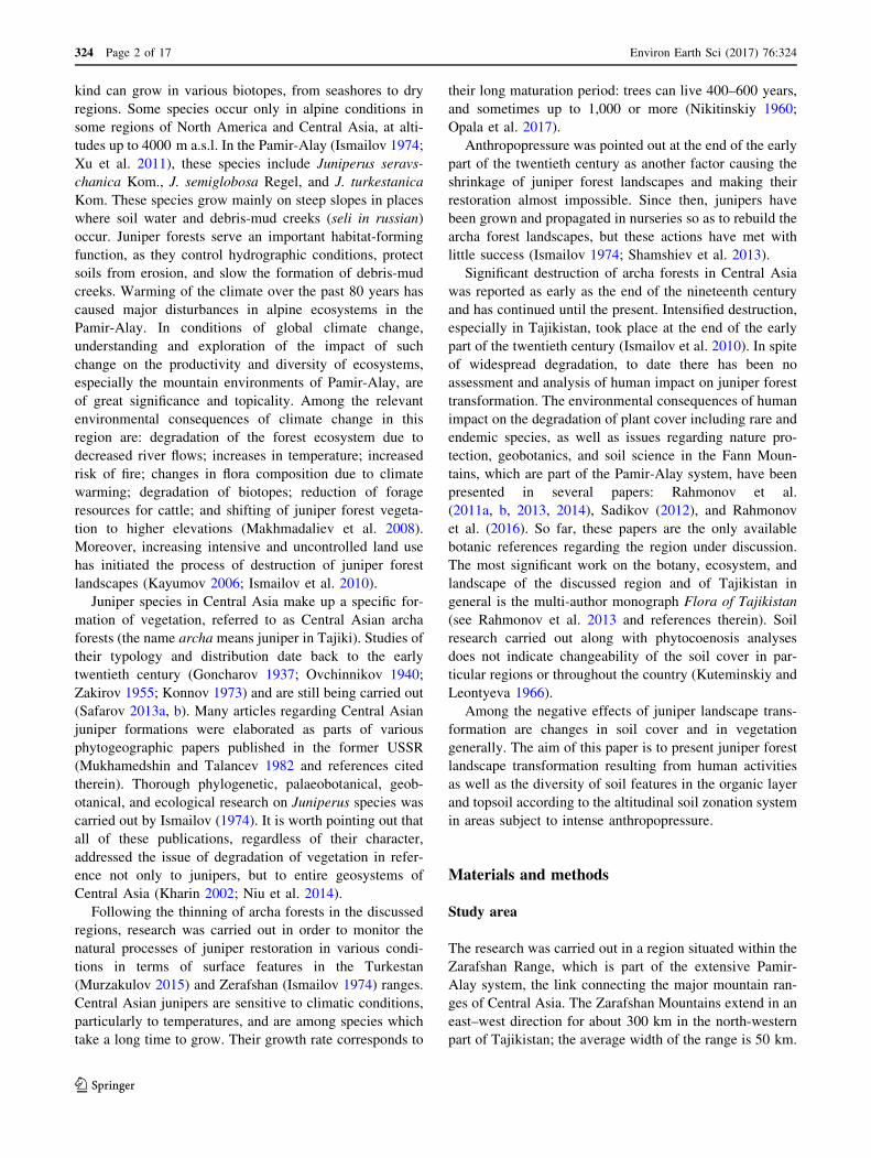
Fig. 3 Distribution of contemporary types of vegetation in the
catchment of the Urej River: 1—altitude points, 2—catchment
boundary, 3 and 5—hydrographic network (permanent, seasonal,
water reservoirs), 6—irrigated farmland 7—steppified farmland after
felling of junipers, 8—peat bogs, 9—juniper forests, 10—alpine
meadow-steppe vegetation, 11—rocky surface and scree with scarce
vegetation, 12—glaciers and permanent snow, 13—Juniperus
semiglobosa, 14—Juniperus seravschanica
324 Page 6 of 17 Environ Earth Sci (2017) 76:324
123

Table 1 Characterisation of soil sampling locations
No. of
samples
Soil
horizons
Morphological description of soil horizons Mean sea
level (MSL)
Geographical
coordinates
1 AC Mineral horizon, thick matter, under dense scrub (Rosa lutea), slope about 45� 3470 39�15019.0000N
68�13014.4000E
2 C Parent rock horizon, degraded topsoil horizon, stone-gravel fraction, eroded soil cover,
dominant cushion vegetation, adjacent to juniper forests, slope to 60�3546 39�15036.6500N
68�13027.5100E
3 Olh Organic horizon, poorly decomposed, dense, sodded, alpine meadow with a share of
Geranium regelii, intensive grazing, slope 25�3511 39�15032.8800N
68�13023.8300EAB Mixed topsoil and enrichment horizon, high share of herbaceous plant roots, dense
structure, dominating fine fractions, alpine landscape
4 OC Organic horizon, loose, mixed with bedrock, mixed fraction matter, upper forest line,
thickset specimen of J. semiglobosae, forest landscape, slope 40�3119 39�15030.1800N
68�12011.0200E
5 OA Organic-humus horizon, presence of farm animals, very hard crust, clearly layered
surface, slope 35�3416 39�15041.3700N
68�13004.5600E
6 OA Organic-mineral horizon, loose structure, within a typical alpine belt of Acantholimon
sp., slope 45�3536 39�15023.5100N
68�13012.8200E
7 A/C Humus horizon with features of parent rock, loose structure, various fraction
composition, under a meadow with Geranium regelii dominant on the northern slope,
directly within the glacier melting zone, slope 45�
3536 39�15023.5100N
68�13012.8200E
8 OA Organic-topsoil horizon, loose structure, non-consolidated mineral and organic matter,
under Astragalus sp, slope 45�3536 39�15023.5100N
68�13012.8200E
9 Olh Organic horizon, clearly divided into sub-horizons, sub-horizons interspersed with
mycelia, built from remains of juniper
2883 39�15020.5700N
68�11044.1900EAB Mixed topsoil and subsoil, soil develops on a bottom moraine, coarse-grained limestone
matter, soil range is limited by the canopy, slope 5� m a.s.l., juniper landscape
10 O Organic horizon built from bark, shells, and juniper berries in various stages of decay,
on top of a moraine, under J. semiglobosa
2858 39�15025.1900N
68�11008.6100EAB Mixed topsoil and subsoil, various grain fractions with dominant stone material,
slope 5�11 A Humus horizon, various fraction material with dominant gravel, in bush-scrub
community within steppified forests, slope 40�2026 39�15056.0700N
68�11002.0900E
12 A Humus horizon, dominating rock fraction, loose structure, numerous roots, under
Cerasus verrucosa, slope 60�2113 39�19056.0700N
68�07002.0900E
13 AC Mixed horizon, material of various grain sizes with dominant gravel fraction, loose
structure, under J. seravshanica, slope 70�2008 39�19047.8300N
68�06052.1500E
14 AB Mixed horizon with dominating subsoil horizon, rock fractions, under biogroup
Ephedra sp., J. seravshanica, slope 35�2524 39�21028.4300N
68�0608400E
15 AB Mixed horizon, dominant fine sand, high share of rock fraction, under Juniperus
seravshanica, slope 25�2428 39�19052.4000N
68�07041.6900E
16 Ol Organic horizon, built mainly from juniper litter, poorly decayed, animal excrement,
slope 10�2680 39�19047.2200N
68�07008.2100EAB Mixed topsoil and subsoil horizon, fine grain fraction, dense structure, overgrown with
herbaceous plant roots, gradual transition
Bbr Subsoil horizon, fine fraction material, proliferation of roots, dense structure
C Parent rock built mainly from fine fraction material, share of limestone
17 AB Mixed topsoil and subsoil horizon, dense structure, mixed fraction material, under
Artemisia dracunculus, steppified landscape, slope 35�2593 39�20005.8200N
68�08003.24800E
18 AB Mixed horizon with subsoil features, dominant rock fraction, under Juniperus
seravshanica, Rosa ecea, slope 30�2419 39�20020.0800N
68�07046.8500E
Environ Earth Sci (2017) 76:324 Page 7 of 17 324
123
below that, it possessed features of the cambic horizon
(B) and frequently of parent rock (C), generally not pro-
cessed chemically. Apart from areas under canopies, these
soils are generally very shallow.
The granulometry of the soil material was determined
mainly in the laboratory, but partly on site. Standard methods
were used to determine the following parameters: soil colour
according to Munsell; pH in water and in 1 M KCl, total
organic carbon and CaCO3 using the CS-530 Carbon/Sulphur
Analyser (Eltra) method; total nitrogen (Ntot) using the
Kjeldahl method; available phosphorus (Pavail) and magne-
sium (Mgavail) using the Egner–Riehm method (Bednarek
et al. 2004); and total phosphorus (Ptot) using Bleck’s
method, as modified by Gebhardt (1982). Each measurement
concerning the physico-chemical properties of soils was
repeated three times; mean values were compiled in Table 3.
Results
Most frequently, juniper forest landscapes occupy alpine
areas (Fig. 3). In the highest parts of the mountains, forests
of the phytocoenosis with Juniperus semiglobosa are based
on a single species. Dry and dead high trees, which can
often be found within the area, are removed for firewood,
disturbing the natural biogeochemical cycle of the
ecosystem. Forests with J. seravschanica dominate on
steep slopes. The areas at the mouth of the Urej River are
covered by xerophilous shrubs in habitats formerly over-
grown by forests.
Juniper forest landscape
The research distinguished three groups of phytocoenoses:
those with a dominant share of Juniperus seravschanica,
those with a dominant share of J. semiglobosa, and mixed,
combining both of the species (Fig. 3). Distribution of
these species in terms of altitude is a function of their
ecological tolerance to temperature fluctuations. Species
diversification within these landscapes depends on slope
exposition and surface relief. Hence, associations with both
Juniperus seravschanica and J. semiglobosa feature sev-
eral varieties of phytocoenoses related to dominant species.
The association Juniperus seravschanica, growing at
1200–2400 m a.s.l., creates biocoenoses which are com-
paratively rich in terms of species composition. Landscape
physiognomy is determined by habitat and climatic con-
ditions, relief forms, and, currently, by the presence of
humans. This association is most commonly found on
northern and north-eastern slopes. Based on the species
which dominate and shape their physiognomy, several
varieties with J. seravschanica were distinguished within
this landscape. These include: dominant Festuca sulcata,
Scorzonera acanthoclada, Stipa turkestanica, Artemisia
lehmanniana, Scutellaria hissarica, Cousinia hissarica,
Artemisia dracunculus, Ziziphora clinopodioides, and
Thymus zeravschanicus.
Shrubs play an important part in juniper forests with J.
seravschanica. The most common species include Co-
toneaster oliganthus, C. multiflora, C. hissarica, Rosa
fedtschenkoana, R. ecae, Ephedra equisetina, Astragalus
variegates, Spiraea hypericifolia, Lonicera bracteolaris, L.
simulatrix, and Berberis oblongata, among others.
It should be emphasised that the highly fragmented
relief, mosaic-like land-soil conditions, and humidity all
have a strong impact on vegetation. These factors justify
the division of landscapes based on the most common
facies of archa forests with dominating species.
The association Juniperus semiglobosa favours higher
altitudes (2400–3500 m a.s.l.) and is characterised by well-
preserved tree stand structures resulting from relatively
weak human pressure (regions with little or no access for
humans). The domination of particular species, related to
ecological and topoclimatic conditions and the prevailing
relief, can be observed in different parts of these forests.
Hence, various facies resulting from a dominant species
making up the undergrowth can be distinguished within the
phytocoenosis with J. semiglobosa. Dominant species are
represented by Artemisia lehmanniana, A. dracunculus,
Ligularia thomsonii, Poa litvinoviana, P. relaxa, Ferula
kokanica, Hypericum scabrum, Ziziphora pamiroalaica,
Gentiana oliveri, Campanula glomerata, Scabiosa
songorica, Polygonum coriarium, Eremurus olgae, Ono-
brychis echidna, Cousinia franchetii, C. verticillaris,
Acantholimon velutinum, and others. The share of the
mentioned species in the undergrowth often reaches
60–80% of a given patch, which generally is characterised
by a small area. In higher parts of the mountains, these are
single-species forests in which, compared to the association
J. seravschanica, shrubs occur individually as deciduous
species due to unfavourable bioclimatic conditions. Rosa
fedtschenkoana, R. ecae, and Berberis oblongata can be
found here individually as well as, more often, Sorbus
tianschanica and others.
The ecoclines between the Juniperus semiglobosa and J.
seravschanica formations create a mixed phytocoenosis of
the two species, which occurs between 2450 and 2800 m
a.s.l. and is characterised by an intermediate composition
with a large share of bushes and undershrubs of species of
the genera Rosa, Lonicera, Berberis, Cotoneaster, Ephe-
dra, Sorbus, and Cerasus.
Human impact on juniper landscape transformation
The results of our research on juniper forest transformation
are derived from direct field observations. First of all,
324 Page 8 of 17 Environ Earth Sci (2017) 76:324
123
numerous remains of trunks of the discussed trees, both old
(characterised by large circumferences of 1.5 m) and
young, can be found. Some are partly decomposed; most
have completely dried out. The observations showed that
young trunks were covered with bark with living tissue
(cambium) discovered underneath, proving that these
individual trees had been cut down quite recently. The
trunks confirm the common occurrence of the species in the
past, which can be seen in the etymology of names of
certain locations, such as Artuch, which means juniper
forests.
Another degradation factor for juniper forests is sea-
sonal pasture from May to August. Grazing within step-
pified forests on slopes greater than 30� causes the
acceleration of erosion processes and degradation of soil
horizons. Herds of cattle also eat small young juniper
seedlings, significantly inhibiting regeneration.
The consequences of uncontrolled tourism in this area
are primarily related to the often unconscious causation of
fire. The presence of etheric oils in juniper needles causes
them to burn quickly, and thus they increase the range of
fire and the shrinkage of forest areas, as has occurred in the
central part of the Urej catchment.
Glades within the juniper phytocoenosis (especially on
the northern slopes) are exploited for agricultural purposes
with the use of fertilisation and irrigation (Photograph 3).
This causes changes in species composition. Excessive
irrigation has initiated the processes of earthflow within the
juniper forest ecosystems. The impact and effect of human
activity on juniper forest ecosystems is illustrated in
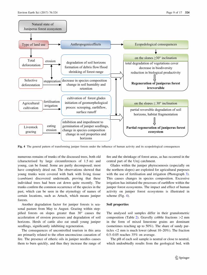
scheme (Fig. 4).
Soil properties
The analysed soil samples differ in their granulometric
composition (Table 2). Gravelly cobble fractions [2 mm
in the form of mixed limestone grains are dominant
(sometimes reaching up to 50%). The share of sandy par-
ticles\2 mm is much lower (about 10–20%). The fraction
0.5–0.05 reaches 35% on average.
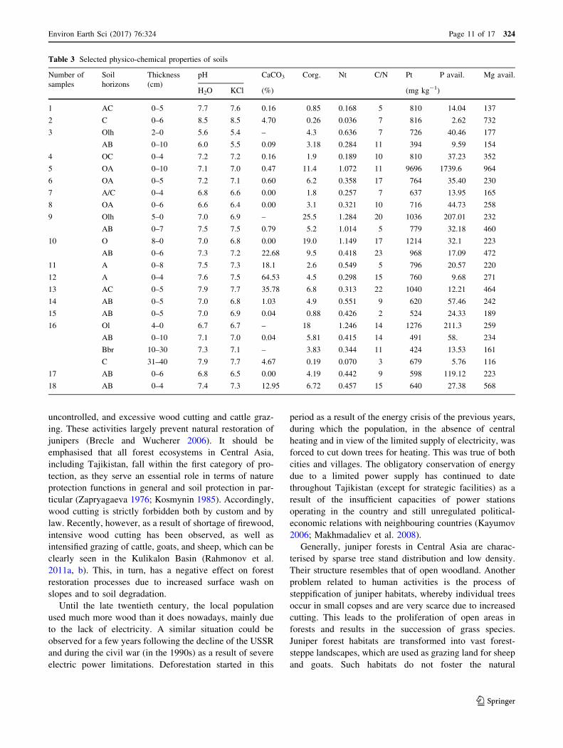
The pH of each soil sample is neutral or close to neutral,
which undoubtedly results from the geological bed, with
eating erosion
fertilisationirrigation
steppization
erosionTotaldeforestation
Natural state ofJuniperus forest ecosystem
Type of land use Anthropogeniceffects Ecopedological consequences
Selective deforestation
Agriculturalcultivation
Livestock grazing
degradation of soil horizonsformation of debris flow/flood
shrinking of forest range
decrease in species compositionchange in soil humidity and
retention
cultivation of forest gladesinitiation of geomorphological proces: screeping, earthflow,
surface runoff
inhibition and impediment to germination of juniper seedlings, change in species composition
change in soil properties and horizons
total degradation of vegetations cover decrease in biodiversity
reduction in biological productivity
Regeneration of juniperus forest irreversible
partial reversible degradation of soil horizons, habitat fragmentation
Partial regeneration of juniperus forest ecosystem
on the slopes ≥30° inclination
on the slopes ≤ 30° inclination
Fig. 4 The general pattern of transforming juniper forests under the influence of human activity and its ecopedological consequences
Environ Earth Sci (2017) 76:324 Page 9 of 17 324
123
the exception of organic horizons related to acidic juniper
litter (Table 3). Values of pH range between 6.0 and 8.5 in
water and 5.5–8.5 in KCl. All analysed samples show
varying concentrations of available potassium. Higher
concentrations were detected in organic
(O) (40.46–211 mg kg-1) and mixed (OA)
(2.61–119 mg kg-1) horizons. Sample 5 represents a site
associated with intense grazing and presence of animals.
Both available P (1739.6 mg kg-1) and total P
(9696 mg kg-1) at this site attain the highest values of all
samples (Table 1). Total phosphorus (Ptot) shows a high
degree of variability (Table 3); its maximum values are
also related to cattle grazing in this area. High concentra-
tions of total phosphorus do not affect concentrations of
available phosphorus. Available magnesium ranges from
116 to 964 mg kg-1 (Table 3). The highest concentration,
as with those of phosphorus and nitrogen, was detected in
sample 5.
Organic carbon (Corg) concentration is variable, with its
highest value reported in organic horizons (4.3–25%); in
mineral-organic horizons, it ranges from 0.26 to 11.40%
(Table 3). Similar relationships were found in the case of
total nitrogen concentrations. A clear relationship can be
seen between concentrations of organic carbon and nitro-
gen. The C/N ratio is low in all research profiles, indicating
mineralisation of organic matter, which is generally scarce
in these ecosystems. Variations in CaCO3 concentrations
are presented in Table 3.
Discussion
Functioning of juniper forest vegetation
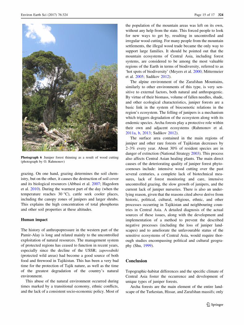
Juniper forests are of great importance: on one hand, they
protect water reserves and serve counter-erosional func-
tions; on the other, they provide high-quality building
material and firewood (Photographs 4, 5, 6). At present,
juniper forests all over Tajikistan, including the Fann
Mountains, have been badly damaged as a result of chaotic,
Table 2 Granulometric composition of soil-building formations
Nr of
samples
Soil
horizons
Thickness
(cm)
Colour of soil Rock Grain size composition mm (%) of fine earth
Wet Dry Sand Silt
[2.0 2.0–1.0 1.0–0.5 0.5–0.25 0.25–0.1 0.1–0.05 \0.05
(mm)
1 AC 0–5 5Y4/1 5Y6/1 34.4 13.8 13.9 11 9.3 6.4 11.2
2 C 0–6 2.5Y5/1 2.5Y7/1 22.8 18.6 9.3 17.4 18.2 3.7 8.1
3 Olh 2–0 2.5Y3/3 2.5Y4/3 n.d n.d n.d n.d n.d- n.d n.d
AB 0–10 10YR2/2 10YR4/2 12.6 7.3 9.1 8.7 36 13.6 12.9
4 OC 0–4 2.5Y5/2 2.5Y6/2 15.8 11.8 10.5 12.9 17.6 17.3 14.3
5 OA 0–10 2.5Y3/2 2.5Y4/2 28.7 13.9 11.5 12.3 13.8 11.6 8.2
6 OA 0–5 2.5Y3/2 2.5Y6/2 10 5.2 10.4 16.1 24.9 15.6 17.8
7 A/C 0–4 2.5Y3/2 2.5Y4/2 11.5 7.3 14.3 17 19.7 13.4 16.8
8 OA 0–6 2.5Y3/3 2.5Y5/3 14.3 6.6 10.9 20.1 23 15 10
9 Olh 5–0 10YR2/2 10YR2/3 n.d n.d n.d n.d n.d n.d n.d
AB 0–7 10YR2/1 10YR3/1 26 8.5 9.5 14.1 19.8 13.5 8.6
10 O 8–0 5YR1.7/1 5YR2/1 n.d n.d n.d n.d n.d n.d n.d
AB 0–6 10YR2/2 10YR3/2 46.6 12.4 8.6 8.2 8.7 6.9 8.6
11 A 0–8 10YR2/2 10YR4/2 20.5 6.3 9.9 17.7 19.5 10.8 15.3
12 A 0–4 10YR2/2 10YR4/2 37.6 9.1 8.8 10.7 16.8 12.4 4.5
13 AC 0–5 2.5Y3/3 2.5Y5/2 19.4 16.4 18.4 17.7 14.1 7.4 6.6
14 AB 0–5 10YR2/2 10YR4/2 19 7.2 9.8 19 17.8 11.8 15.3
15 AB 0–8 10YR2/3 10YR4/3 10.4 8.9 13.8 12.8 14.7 34.1 5.5
16 Ol 4–0 10YR4/2 10YR5/2 n.d n.d n.d n.d n.d n.d n.d
AB 0–10 10YR2/2 10YR3/2 7.9 14.2 12.9 14.4 15.3 28.7 6.6
Bbr 10–30 10YR2/2 10YR3/2 7.4 6.2 12.8 22 21.2 13.9 16.5
C 31–40 10YR5/2 10YR7/2 16.8 3.3 6.3 8.9 27.4 23 14.3
17 AB 0–6 2.5Y3/2 2.5Y4/2 18 6.8 12.3 13.5 16.6 14.9 17.9
18 AB 0–4 10YR2/2 10YR4/2 17.8 9.1 11.5 21.8 14.8 14.4 10.6
324 Page 10 of 17 Environ Earth Sci (2017) 76:324
123
uncontrolled, and excessive wood cutting and cattle graz-
ing. These activities largely prevent natural restoration of
junipers (Brecle and Wucherer 2006). It should be
emphasised that all forest ecosystems in Central Asia,
including Tajikistan, fall within the first category of pro-
tection, as they serve an essential role in terms of nature
protection functions in general and soil protection in par-
ticular (Zapryagaeva 1976; Kosmynin 1985). Accordingly,
wood cutting is strictly forbidden both by custom and by
law. Recently, however, as a result of shortage of firewood,
intensive wood cutting has been observed, as well as
intensified grazing of cattle, goats, and sheep, which can be
clearly seen in the Kulikalon Basin (Rahmonov et al.
2011a, b). This, in turn, has a negative effect on forest
restoration processes due to increased surface wash on
slopes and to soil degradation.
Until the late twentieth century, the local population
used much more wood than it does nowadays, mainly due
to the lack of electricity. A similar situation could be
observed for a few years following the decline of the USSR
and during the civil war (in the 1990s) as a result of severe
electric power limitations. Deforestation started in this
period as a result of the energy crisis of the previous years,
during which the population, in the absence of central
heating and in view of the limited supply of electricity, was
forced to cut down trees for heating. This was true of both
cities and villages. The obligatory conservation of energy
due to a limited power supply has continued to date
throughout Tajikistan (except for strategic facilities) as a
result of the insufficient capacities of power stations
operating in the country and still unregulated political-
economic relations with neighbouring countries (Kayumov
2006; Makhmadaliev et al. 2008).
Generally, juniper forests in Central Asia are charac-
terised by sparse tree stand distribution and low density.
Their structure resembles that of open woodland. Another
problem related to human activities is the process of
steppification of juniper habitats, whereby individual trees
occur in small copses and are very scarce due to increased
cutting. This leads to the proliferation of open areas in
forests and results in the succession of grass species.
Juniper forest habitats are transformed into vast forest-
steppe landscapes, which are used as grazing land for sheep
and goats. Such habitats do not foster the natural
Table 3 Selected physico-chemical properties of soils
Number of
samples
Soil
horizons
Thickness
(cm)
pH CaCO3 Corg. Nt C/N Pt P avail. Mg avail.
H2O KCl (%) (mg kg-1)
1 AC 0–5 7.7 7.6 0.16 0.85 0.168 5 810 14.04 137
2 C 0–6 8.5 8.5 4.70 0.26 0.036 7 816 2.62 732
3 Olh 2–0 5.6 5.4 – 4.3 0.636 7 726 40.46 177
AB 0–10 6.0 5.5 0.09 3.18 0.284 11 394 9.59 154
4 OC 0–4 7.2 7.2 0.16 1.9 0.189 10 810 37.23 352
5 OA 0–10 7.1 7.0 0.47 11.4 1.072 11 9696 1739.6 964
6 OA 0–5 7.2 7.1 0.60 6.2 0.358 17 764 35.40 230
7 A/C 0–4 6.8 6.6 0.00 1.8 0.257 7 637 13.95 165
8 OA 0–6 6.6 6.4 0.00 3.1 0.321 10 716 44.73 258
9 Olh 5–0 7.0 6.9 – 25.5 1.284 20 1036 207.01 232
AB 0–7 7.5 7.5 0.79 5.2 1.014 5 779 32.18 460
10 O 8–0 7.0 6.8 0.00 19.0 1.149 17 1214 32.1 223
AB 0–6 7.3 7.2 22.68 9.5 0.418 23 968 17.09 472
11 A 0–8 7.5 7.3 18.1 2.6 0.549 5 796 20.57 220
12 A 0–4 7.6 7.5 64.53 4.5 0.298 15 760 9.68 271
13 AC 0–5 7.9 7.7 35.78 6.8 0.313 22 1040 12.21 464
14 AB 0–5 7.0 6.8 1.03 4.9 0.551 9 620 57.46 242
15 AB 0–5 7.0 6.9 0.04 0.88 0.426 2 524 24.33 189
16 Ol 4–0 6.7 6.7 – 18 1.246 14 1276 211.3 259
AB 0–10 7.1 7.0 0.04 5.81 0.415 14 491 58. 234
Bbr 10–30 7.3 7.1 – 3.83 0.344 11 424 13.53 161
C 31–40 7.9 7.7 4.67 0.19 0.070 3 679 5.76 116
17 AB 0–6 6.8 6.5 0.00 4.19 0.442 9 598 119.12 223
18 AB 0–4 7.4 7.3 12.95 6.72 0.457 15 640 27.38 568
Environ Earth Sci (2017) 76:324 Page 11 of 17 324
123

restoration of junipers, as they surrender to herbaceous
vegetation, and are additionally consumed by animals. The
process of steppification is continuing, and areas already
steppified are used as agricultural land regardless of
obstacles and unfavourable orographic conditions (Pho-
tographs 1, 2, 3). Agricultural use of land in the arid cli-
mate which dominates here has little chance of success
without artificial irrigation; on the other hand, installation
of a water pipeline several kilometres long would soon
cause massive degradation of the environment, especially
as a result of erosion (Golosov et al. 2015).
The most natural environments, untouched by humans,
are preserved in forests situated at altitudes between 2800
and 3300 m a.s.l., especially on steep slopes and situated at
least several kilometres away from human settlements.
Transporting wood from such areas is difficult or
Photograph 1 Animal grazing
in the zone of the upper line of
juniper ecosystems with visible
traces of soil degradation caused
by grazing (photograph by O.
Rahmonov)
Photograph 2 Steppified
juniper forests in the
background of the U-shaped
valley (photograph by O.
Rahmonov)
324 Page 12 of 17 Environ Earth Sci (2017) 76:324
123

completely impossible, since local residents use mainly
donkeys for hauling wood. These landscapes are most
commonly associated with J. semiglobosa in the research
area.
Reforestation processes
According to the UN’s FAO, 2.9%, or about 410,000 ha, of
Tajikistan is forested. Of this area, 72.4% (297,000 ha) is
classified as primary forest and the remainder, 101,000 ha,
as planted forest. The changes in forest cover are irrele-
vant: between 1990 and 2010, Tajikistan lost an average of
100 ha or 0.02% per year. In total, between 1990 and 2010,
Tajikistan gained 0.5% of forest cover, or around 2000 ha.
The state agency reports different values for the forest
cover area (416,700 ha) and percentage (3%) (TajStat
2014).
The Republic of Tajikistan is currently implementing a
programme of forest restoration with the support of inter-
national organisations, including the German Federal
Ministry for Economic Cooperation and Development
(BMZ), represented by the German Society for Interna-
tional Cooperation (GIZ, or Deutsche Gesellschaft fur
Internationale Zusammenarbeit), within the framework of a
project entitled ‘Adaptation to climate change through
sustainable forest management’. The executive agency is
the Forestry Agency of the Government of Tajikistan.
Tajikistan is among the Asian countries most severely
affected by climate change (Kayumov 2006; Makhmadaliev
et al. 2008). This is evident from the growing incidence of
natural disasters, such as landslides, floods, and droughts,
and a general decline in the availability and quality of water.
Following the collapse of the Soviet Union, large areas were
deforested to meet the above-mentioned need for fuelwood.
This now makes the country more vulnerable to climate
change and exacerbates its negative impact (Karthe et al.
2015; Niu et al. 2014). Conflicts between forestry offices
and the local population over land use also perpetuate the
misuse and degradation of forest areas (Kayumov 2006;
Makhmadaliev et al. 2008). Forest ecosystems play a key
role in the lives of Tajikistan’s rural population. Firewood,
fodder, medicinal plants, fruit, and nuts can be sold locally
at a profit and represent an important source of income
(Eisenman et al. 2013). Forests also perform an essential
function in regulating the water balance and providing
protection against natural disasters. Restoration and pro-
tection of forests are therefore of vital importance in the
process of adapting to climate change.
Soil conditions
The Fann Mountains are characterised by large differences
in altitude within relatively small distances. This
undoubtedly has a large impact on scenic diversity and its
mosaic-like character. High steep ridges and deep narrow
valleys foster processes of intense downwash, which
destroy the soil cover down to the bedrock. Specific
physiogeographic features of the research area determine
the formation of specific types of mountain soils (Kute-
minskiy 1960; Kuteminskiy and Leontyeva 1966).
In terms of granulometry, the analysed soil samples are
highly diversified, especially in the fraction [2.0 mm
Photograph 3 Felled juniper
forests are replaced with arable
land due to relatively high-
quality soils (source: Google
Earth Image �2016 CNES/
Astrium 39�19051.3500N,
68�07020.8100E)
Environ Earth Sci (2017) 76:324 Page 13 of 17 324
123

(mostly associated with high altitudes; see Table 1).
Compare with other fractions, as well as the diversity of
output formations (glacial drifts) and their vulnerability to
weathering and anthropopressure, material from these
fractions is more uniform.
It should be pointed out that vegetation colonises areas
where soil parts dominate and, after forming obvious
clumps, stores dust transported by wind within these
clumps. Typical phytogenic hillocks are formed in this
way. Air often carries a great quantity of dust in this area,
which causes serious problems for the population.
As was mentioned in ‘‘Materials and Methods’’, the
samples were taken from the organic-topsoil horizon of the
rhizosphere. Most of these samples lack the organic hori-
zon (O) and their accumulation horizon is not very thick.
Mineral formations are mixed with fine organic material
(dead thalli of crustose lichens, which are not always
separable). Therefore, most samples are marked as mixed
horizon (in which mineral material dominates). Directly
under this horizon lies bedrock. The topsoil’s low thickness
values are related to water and wind erosion and mechan-
ical damage caused by animals. Due to lack of vegetation,
animals frequently tear out roots, thus degrading soils
already characterised by poor compactness. Samples from
the AB (partly degraded topsoil) and A horizons occur
under dense grass communities and within the phytogenic
field and are limited to the areas under canopies.
The results obtained from the test region are close to
those from the western Alay Mts. (Glaser et al. 2000) under
similar vegetation. The importance of grain size composi-
tion, slope angle, porosity of mountain soils, frequent
erosion, and land use, all of which are unfavourable for the
creation of conditions for nutrient accumulation and soil
development, was stated there as well. Other researchers
(e.g. Cecillion et al. 2010) attribute important roles in soil
development mainly to dynamic geomorphological pro-
cesses and arid climate changeability at different altitude
levels, ignoring the human role in the status of these sen-
sitive mountain ecosystems. The latter, in turn, contributes
to the formation of soil mosaic typical of mountain areas on
which plant islands are created, along with the phytogenic
fields under their canopies. The biocoenotic importance of
Juniperus seravschanica and J. semiglobosa is related to,
inter alia, the formation of phytogenic field and soil
islands; deforestation exposes soil to erosion, resulting in
the disappearance of vegetation. Mountain soils of the
analysed area are used especially for intensive summer
Photograph 4 Juniperus semiglobosa. This tree’s crooked trunk and
branches protect it from being used for timber (photograph by O.
Rahmonov)
Photograph 5 Juniperus semiglobosa, with traces of human activ-
ities (photograph by O. Rahmonov)
324 Page 14 of 17 Environ Earth Sci (2017) 76:324
123
grazing. On one hand, grazing determines the soil chem-
istry, but on the other, it causes the destruction of soil cover
and its biological resources (Abbasi et al. 2007; Hagedorn
et al. 2010). During the warmest part of the day (when the
temperature reaches 30 �C), cattle seek cooler places,
including the canopy zones of junipers and larger shrubs.
This explains the high concentration of total phosphorus
and other soil properties at these altitudes.
Human impact
The history of anthropopressure in the western part of the
Pamir-Alay is long and related mainly to the uncontrolled
exploitation of natural resources. The management system
of protected regions has ceased to function in recent years,
especially since the decline of the USSR; zapovedniki
(protected wild areas) had become a good source of both
food and firewood in Tajikistan. This has been a very bad
time for the protection of Tajik nature, as well as the time
of the greatest degradation of the country’s natural
environment.
This abuse of the natural environment occurred during
times marked by a transitional economy, ethnic conflicts,
and the lack of a consistent socio-economic policy. Most of
the population of the mountain areas was left on its own,
without any help from the state. This forced people to look
for new ways to get by, resulting in uncontrolled and
irregular wood cutting. For many people from the mountain
settlements, the illegal wood trade became the only way to
support large families. It should be pointed out that the
mountain ecosystems of Central Asia, including forest
systems, are considered to be among the most valuable
regions of the Earth in terms of biodiversity, referred to as
‘hot spots of biodiversity’ (Meyers et al. 2000; Mittermeier
et al. 2005; Sadikov 2012).
The alpine environment of the Zarafshan Mountains,
similarly to other environments of this type, is very sen-
sitive to external factors, both natural and anthropogenic.
By virtue of their biomass, volume of fallen needles, shade,
and other ecological characteristics, juniper forests are a
basic link in the system of biocoenotic relations in the
region’s ecosystem. The felling of junipers is a mechanism
which triggers degradation of the ecosystem along with its
endemic species. Archa forests play a protective role within
their own and adjacent ecosystems (Rahmonov et al.
2011a, b, 2013; Sadikov 2012).
The surface area contained in the main regions of
juniper and other rare forests of Tajikistan decreases by
2–3% every year. About 30% of resident species are in
danger of extinction (National Strategy 2003). This process
also affects Central Asian healing plants. The main direct
causes of the deteriorating quality of juniper forest phyto-
coenoses include: intensive wood cutting over the past
several centuries, a complete lack of biotechnical mea-
sures, lack of forest monitoring and care, intensive
uncontrolled grazing, the slow growth of junipers, and the
current lack of juniper nurseries. There is also an under-
lying reason, given that the reasons cited above derive from
historic, political, cultural, religious, ethnic, and other
processes occurring in Tajikistan and neighbouring coun-
tries in Central Asia. A detailed diagnosis of the actual
sources of these issues, along with the development and
implementation of a method to prevent the described
negative processes (including the loss of juniper land-
scapes) and to ameliorate the unfavourable status of the
sensitive ecosystems of Central Asia, would require thor-
ough studies encompassing political and cultural geogra-
phy (Shu, 1999).
Conclusion
Topographic-habitat differences and the specific climate of
Central Asia foster the occurrence and development of
unique types of juniper forests.
Archa forests are the main element of the entire land-
scape of the Turkestan, Hissar, and Zarafshan massifs; only
Photograph 6 Juniper forest thinning as a result of wood cutting
(photograph by O. Rahmonov)
Environ Earth Sci (2017) 76:324 Page 15 of 17 324
123

small areas of the Fann Mountains have been left unaf-
fected by human economic activities. In most cases, trees
of the species Juniperus semiglobosa and J. seravschanica
were cut down for the building industry and, recently, for
firewood. This increased soil erosion on steeper slopes,
causing overall degradation of the landscape.
The soil cover is heterogeneous in terms of both
mechanical composition and chemical properties.
Depending on topographic conditions, slope exposition,
altitude, and type of vegetation, the soils occurring in the
area in question range from fine-grained to poorly devel-
oped coarse rock. Debris of various sizes can be observed
in the soil profile.
The most destructive forms of anthropopressure in the
discussed area include grazing of cattle, sheep, and goats;
illegal wood cutting for building and firewood; and non-
organised tourism.
Acknowledgements The authors wish to thank Dr. G. Kłys, MSc.
T. Parusel and Kamil Rahmonov for their hospitality and assistance in
the field. The research was supported by National Science Centre
(NCN) Grant No. 2013/09/B/ST10/00634 ‘Comparison of thermal
variability during the last millennium in the mountains of Central
Asia and Central Europe’. We gratefully acknowledge to anonymous
reviewers for their constructive comments.
Open Access This article is distributed under the terms of the
Creative Commons Attribution 4.0 International License (http://crea
tivecommons.org/licenses/by/4.0/), which permits unrestricted use,
distribution, and reproduction in any medium, provided you give
appropriate credit to the original author(s) and the source, provide a
link to the Creative Commons license, and indicate if changes were
made.
References
Abbasi KM, Zafar M, Razaq Khan S (2007) Influence of different
land-cover types on the change of selected soil properties in the
mountain region of Rawalakot Azad and Kashmir. Nutr Cycl
Agroecosyst 78:97–110
Bednarek R, Dziadowiec H, Pokojska U, Prusinkiewicz Z (2004) The
ecological and pedological investigations. WN PWN, Warszawa
(in Polish)
Brecle SW, Wucherer W (2006) Vegetation of the Pamir (Tajikistan):
land use and desertification problems. In: Spehn EM, Korner C,
Liberman M (eds) Land-use change and mountain biodiversity.
CRC Press, Boca Raton, pp 239–251
Cecillion L, De Mello NA, De Danieli S, Jean-Jaques B (2010) Soil
macro aggregate dynamics in a mountain spatial climate
gradient. Biogeochemistry 97:31–43
Eisenman SW, Zaurov DE, Struwe L (eds) (2013) Medicinal plants of
Central Asia: Uzbekistan and Kyrgyzstan. ISBN: 978-1-4614-
3911-0 (Print) 978-1-4614-3912-7 (Online). Springer, Berlin
Gebhardt H (1982) Phosphatkartierung und bodenkundliche Gelande-
untersuchungen zur Eingrenzung historischer Siedlungs – und
Wirtschaftsflachen der Geestinsel Flogeln, Kreis Cuxhaven.
Verlag August des Hildesheim, pp 1–10
Glaser B, Turrion MB, Solomon D, Ni A, Zech W (2000) Soil organic
matter quantity and quality in mountain soils of the Alay Range,
Kyrgyzia, affected by land use change. Biol Fertil Soils
31:407–413
Golosov VN, Sosin PM, Belyaev VR, Wolfgramm B, Khodzhaev ShI
(2015) Effect of irrigation-induced erosion on the degradation of
soils in river valleys of the alpine Pamir. Eur Soil Sci
48:325–335
Goncharov NF (1937) Floristical region of Tajikistan and their
vegetation. In: Ovchinnikov PN (ed) Flora Tadzhikistana 5.
Soviet Science Press, Moscow-Leningrad, pp 7–94
Hagedorn F, Mulder J, Jandl R (2010) Mountain soil under a changing
climate and land-use. Biogeochemistry 97:1–5
Ismailov MI (1974) A botanical-geographical overview of Junipers
(Junipers L.) from the perspective of their origin and evolution.
In: Ismailov MI (ed) Questions of ecology and geography of
plants. Donish Press, Dushanbe, pp 15–40
Ismailov MI, Darvoziev M, Sadikov ChCh (2010) The ecosystems of
juniper of Upper Zeravshan under threat. Vestnik Tajik Natl
Univ 3(59):259–262
Karthe D, Chalov S, Borchardt D (2015) Water resources and their
management in central Asia in the early twenty first century:
status, challenges and future prospects. Environ Earth Sci
73(2):487–499
Kayumov AK (2006) The perspective of implementation of Kioto
protocol under the framework of the UN Convention about
climate changes in Tajikistan. Dushanbe
Kharin N (2002) Vegetation degradation in Central Asia under the
impact of human activities. Springer, Berlin, p 182. doi:10.1007/
978-94-019-0425-1
Konnov AA (1973) The junipers forest flora of Shakhristan. Donish
Press, Dushanbe, p 176
Kosmynin AV (1985) Hydrological and soil conservation role of
juniper forest and light forest in the north slope of Alay range.
In: Hydrological researches in mountain forests of USSR.
Frunze, pp 120–131
Kotlyakov VM, Rototaeva OV, Lebedeva IV et al (1993) The
glaciations of Pamiro-Alay. Nauka Press, Moskva, p 254
Kuteminskiy VYa, Leontyeva RS (1966) Soils of Tajikistan. Irfon
Press, Dushanbe, pp 1–324
Kuteminskiy VYa (1960) About soils of Pamir. Tajik SSR Academy
of Science Press 1, 2, Dushanbe, pp 3–14
Makhmadaliev B, Kayumov A, Novikov V, Mustaeva N, Radzhabov
I (2008) Second national information the Republic of Tajikistan
of the framework of the UN Convention about climate change.
The Government of the Republic of Tajikistan, The State
Agency for Hydrometeorology Committee for environmental
protection under Government of the Republic of Tajikistan,
Dushanbe
Meyers N, Mittermeier RA, Mittermeier CG, Da Fonseca GAB, Kent
J (2000) Biodiversity hotspots for conservation priorities. Nature
403:853–858
Mittermeier RA, Gil PR, Hoffmann M, Pilgrim J, Brooks T,
Mittermeier CG, Konstant WR, Lamoreux J, Da Fonseca GAB
(2005) Hotspots revisited: Earth’s biologically richest and most
endangered terrestrial ecoregions. CEMEX, Mexico, p 392
Mukhamedshin KD, Talancev NK (1982) Juniperus forests (forest,
light forest, scrubs). Lesnaia promyshlennost Press, Moskva (inRussian)
Murzakulov SS (2015) Ecological and silvicultutral bases of conser-
vation and sustainable development of juniperus forests of
southern Kyrgyzstan). Izvestia Sankt-Peterburgskoi
lesotekhnicheskoi akademii 212:42–54 (in Russian)National Strategy (2003) National Strategy and action plan on
conservation and sustainable use of biodiversity. Republic of
Tajikistan, Dushanbe
Nikitinskiy YuI (1960) About management in juniperus forests.
Selskoe khozyaistvo Kirgizii 10:36–37 (in Russian)
324 Page 16 of 17 Environ Earth Sci (2017) 76:324
123
Niu R, Du B, Wang Y, Zhang L, Chen T (2014) Impact of fractional
vegetation cover change on soil erosion in Miyun reservoir
basin, China. Environ Earth Sci 72(8):2741–2749
Opala M, Niedzwiedz T, Rahmonov O, Owczarek P, Malarzewski L
(2017) Towards improving the Central Asian dendrochronolog-
ical network—new data from Tajikistan, Pamir-Alay. Den-
drochronologia 41:10–23
Ovchinnikov PN (1940) On the history of the vegetation south of
Central Asia.). Sovriemennaya botanika 3. Leningrad, pp 23–48
(in Russian)
Rahmonov O, Rahmonova M, Snytko VA, Szczypek T (2011a)
Anthropogenic disturbance to vegetation on the polygon-transect
in the Kulikalon depression (Tajikistan). Geogr Nat Resour
32(4):386–393
Rahmonov O, Snytko WA, Szczypek T, Kłys G (2011b) Wpływ
antropopresji na roslinnosc połnocnej czesci Gor Fanskich (na
przykładzie Kotliny Kulikalonskiej). Acta Geographica Silesiana
10:64–73 (in Polish)Rahmonov O, Majgier L, Andrejczuk W, Banaszek L, Karkosz D,
Parusel T, Szymczyk A (2013) Landscape diversity and biodi-
versity of Fann Mountains (Tajikistan). Ekologia (Bratislava)
32(4):388–395
Rahmonov O, Holbegov M, Szczypek T, Snytko VA, Klys G,
Rahmonov M (2014) The consequences of vegetation degrada-
tion under the influence of anthropogenic activity in the territory
of the Zarafshan Range (Western Tajikistan). Geogr Nat Resour
35(2):193–197
Rahmonov O, Niedzwiedz T, Opala M, Malarzewski L, Owczarek P
(2016) Landscape degradation and its effect on the soil-
vegetation relations within juniper forest in the Fann Mountains
(Western Pamir-Alay). In: Halada L, Baca A, Boltiziar M (eds)
Landscape and landscape ecology. Proceedings of the 17th
international symposium on landscape ecology. Nitra,
pp 168–175
Sadikov Ch (2012) The juniperus forests of catchment of Iskander
river (Tajikistan). Lambert Academic Publishing, Saarbrucken,
Germany, pp 1–150
Safarov NM (2013a) Geographical analysis of the flora of Central
Pamir-Alai. Doklady Akademii Nauk Respubliki Tadzhikistan
56(7):569–573 (in Russian)Safarov NM (2013b) Analysis of life forms of the flora of the Central
Pamir-Alai. Doklady Akademii Nauk Respubliki Tadzhikistan
56(8):643–648 (in Russian)Shamshiev BN, Murzakulov SS, Turduev AE (2013) Features of
introduction of acclimatization of trees and shrubs in cultures
and breading ground to restore juniper forests and open
woodlands. Izvestiia OshTU 2:197–202 (in Russian)Shu Y (1999) Economic integration in Central Asia: history and
political geography. Exec Intell Rev 29:40–43
TajStat (2014) Environmental protection in the Republic of Tajik-
istan, Agency of statistics at the President of the Republic of
Tajikistan. http://www.stat.tj
Trohimov AK (1968) The Atlas of Tajik SSR. GUGiK, Dushanbe-
Moscow, pp 1–200 (in Russian)
Vinnichenko GP, Tadzhibekov M (2010) The relief evolution of
Pamir and Hissar-Alay in the Phanerozoic. Doklady Akademii
Nauk Respubliki Tadzhikistan 53(11):879–883 (in Russian)Williams MW, Konovalov VG (2008) Central Asia Temperature and
Precipitation Data, 1879–2003. USA National Snow and Ice
Data Center, Boulder, Colorado, doi:10.7265/N5NK3BZ8
Xu W, Chen X, Luo G, Zhang Q, Lin Q (2011) Soil properties at the
tree limits of the coniferous forest in response to varying
environmental conditions in the Tianshan Mountains, Northwest
China. Environ Earth Sci 63:741–750
Zakirov RZ (1955) Flora and vegetation of Zeravshan river basin.
Uzbek SSR, Academy of Science Press, Tashkent (in Russian)
Zapryagaeva VI (1976) Forest resources of Pamir-Alay Range. Nauka
Press, Leningrad, pp 1–593 (in Russian)
Environ Earth Sci (2017) 76:324 Page 17 of 17 324
123