Embed Size (px)
Citation preview

HyspIRITIR Science Questions
Presented by: Anupma Prakash
Contributors: Michael Abrams; Friedemann Freund; Vince Realmuto; Rob Wright; Lyle Mars; Louis Giglio; Martha Anderson; Richard Allen; James Irons, Dale Quattrochi; Gregory Glass; Jim Crowley; Simon Hook; Fred Kruse; Ivan Csiszar; Rob Green.

TIR Measurements
0
0.1
0.2
0.3
0.4
0.5
0.6
0.7
0.8
0.9
1
3.00 4.00 5.00 6.00 7.00 8.00 9.00 10.00 11.00 12.00 13.00Wavelength (um)
Rel
ativ
e Sp
ectr
al R
espo
nse
H1 (m21)H2 (m28)H3 (a10)H4 (a11)H5 (a12)H6H7H8 (m32)

TIR Measurements
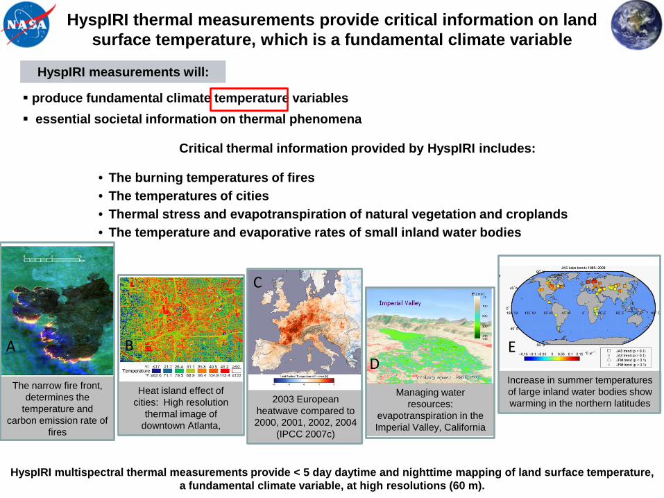
Critical thermal information provided by HyspIRI includes:
• The burning temperatures of fires• The temperatures of cities• Thermal stress and evapotranspiration of natural vegetation and croplands• The temperature and evaporative rates of small inland water bodies
HyspIRI thermal measurements provide critical information on land surface temperature, which is a fundamental climate variable
B
Heat island effect of cities: High resolution
thermal image of downtown Atlanta,
2003 European heatwave compared to 2000, 2001, 2002, 2004
(IPCC 2007c)
C
D
Managing water resources:
evapotranspiration in the Imperial Valley, California
E
Increase in summer temperatures of large inland water bodies show warming in the northern latitudes
A
The narrow fire front, determines the
temperature and carbon emission rate of
fires
produce fundamental climate temperature variables essential societal information on thermal phenomena
HyspIRI multispectral thermal measurements provide < 5 day daytime and nighttime mapping of land surface temperature, a fundamental climate variable, at high resolutions (60 m).
HyspIRI measurements will:

TIR Overarching Science Questions• TQ1. Volcanoes/Earthquakes (MA,FF)
– How can we help predict and mitigate earthquake and volcanic hazards through detection of transient thermal phenomena?
• TQ2. Wildfires (LG,DR)– What is the impact of global biomass burning on the terrestrial biosphere and
atmosphere, and how is this impact changing over time?
• TQ3. Water Use and Availability, (MA,RA)– How is consumptive use of global freshwater supplies responding to changes
in climate and demand, and what are the implications for sustainable management of water resources?
• TQ4. Urbanization/Human Health, (DQ,GG)– How does urbanization affect the local, regional and global environment? Can
we characterize this effect to help mitigate its impact on human health and welfare?
• TQ5. Earth surface composition and change, (AP,JC)– What is the composition and temperature of the exposed surface of the Earth?
How do these factors change over time and affect land use and habitability?

TQ1: Volcanoes and Earthquakes (MA,FF)
• Do volcanoes signal impending eruptions through changes in surface temperature or gas emission rates and are such changes unique to specific types of eruptions? [DS 227]
• What do changes in the rate of lava effusion tell us about the maximum lengths that lava flows can attain, and the likely duration of lava flow-forming eruptions? [DS 226]
• What are the characteristic dispersal patterns and residence times for volcanic ash clouds and how long do such clouds remain a threat to aviation? [DS 224]
• What do the transient thermal anomalies that may precede earthquakes tell us about changes in the geophysical properties of the crust? [DS 227, 229]
• Can the energy released by the periodic recharge of magma chambers be used to predict future eruptions? [DS 227]


TQ2: Wildfires (LG)
• How are global fire regimes changing in response to, and driven by, changing climate, vegetation, and land use practices? [DS 198]
• Is regional and local scale fire frequency changing? [DS 196]
• What is the role of fire in global biogeochemical cycling, particularly trace gas emissions? [DS 195]
• Are there regional feedbacks between fire and climate change?


• How is climate variability (and ENSO) impacting the evaporative component of the global water cycle over natural and managed landscapes? [DS 166, 196, 203, 257, 368]
• What are relationships between spatial and temporal variation in evapotranspiration and land-use/land-cover and freshwater resource management? [DS 196, 203, 368]
• Can we improve early detection, mitigation, and impact assessment of droughts at local to regional scales anywhere on the globe? [DS 166, 196, 203, 368]; How does the partitioning of Precipitation into ET, surface runoff and ground-water recharge change during drought?
• What areas of Earth have water consumption by irrigated agriculture that is out of balance with sustainable water availability? [DS 196, 368]
• Can we increase food production in water-scarce agricultural regions while improving or sustaining quality and quantity of water for ecosystem function and other human uses? [DS 196, 368]
TQ3: Water Use and Availability (MA,RA)


• How do changes in local and regional land cover and land use, in particular urbanization affect surface energy balance characteristics that impact human welfare [DS: 160-161, 166-167, 196, 198]
• What are the dynamics, magnitude, and spatial form of the urban heat island effect (UHI), how does it change from city to city, what are its temporal, diurnal, and nocturnal characteristics, and what are the regional impacts of the UHI on biophysical, climatic, and environmental processes? [DS: 158, 166-168]
• How can the factors influencing heat stress on humans be better resolved and measured. [DS: 156, 158, 160, 183-184]
• How can the characteristics associated with environmentally related health effects, that affect vector-borne and animal-borne diseases, be better resolved and measured? [DS: 156, 158, 160, 183-184]
• How do horizontal and temporal scales of variation in heat flux and mixing relate to human health, human ecosystems, and urbanization? [DS: 156, 160-161, 166-167, 179,184]
TQ4: Human Health and Urbanization (DQ,GG)


TQ5: Earth Surface Composition and Change (AP,LM)
• What is the spectrally observable mineralogy of the Earth's surface and how does this relate to geochemical and surficial processes? [DS 114]
• What is the nature and extent of man-made disturbance of the Earth's surface associated with exploitation of non-renewable resources (oil & gas, mining)? How do these vary over time? [DS 227]
• How do surface temperature anomalies (hot spots) relate to deeper thermal sources, such as buried lava tubes, underground coal fires and engineering structures? How do changes in the surface temperatures relate to changing nature of the deep seated hot source? [DS 243]
• What is the spatial distribution pattern of surface temperatures and emissivities of various land surfaces and how do these influence the Earth’s heat budget?
• What are the water surface temperature distributions in coastal, ocean, and inland water bodies. How do they change, and how do they influence aquatic ecosystems? [DS 378]

TQ5a: What is the spectrally observable mineralogy of the Earth's surface and how does this relate to geochemical and surficial processes? (DS 114)
17
Haselwimmer et al., (2010)
ASTER TIR image end-
members
ASTER TIR MF Interpretation
0.8
1
1.2
1.4
1.6
1.8
Emiss
ivity (
Offse
t for c
larity)
8 10 12 14 Wavelength (micrometers)
Quartz
Olivine
Hornblende
Augite
Muscovite
Albite
0
0.2
0.65
0.85
1.05
1.25
1.45
Emiss
ivity (O
ffset fo
r clarit
y)
8 9 10 11 12 13 14 Wavelength (micrometers)
Dunite
Andesite
Basalt
Gabbro
Diorite
Granite
0
0.2

TQ5e: What are the water surface temperature distributions in coastal, ocean, and inland water bodies, how do they change, and how do they influence aquatic ecosystems? (DS 378)
18
Processed AVHRR TIR image of the coast of the Arctic Alaska coast. Outflow from the Mackenzie River influences temperatures in coastal waters, breakup of sea ice, and thermal habitats of a variety of flora and fauna. Okkonen et al, 2009 (submitted to JGR)
Increase in summer temperatures of large inland water bodies show warming in the northern latitudes
18
Science Issue:• Aquatic habitats are subject of dynamic temperature
regimes, eg. coastal water temperatures vary due to temperatures of the neighboring land surface, outflow from rivers, general ocean circulation patterns, and local wind conditions.
• Flora and fauna in aquatic environments are sensitive to the water temperatures.
• They dynamics of the water temperatures and the controlling processes are not well understood.
Tools: • HyspIRI TIR data with NEΔT < 0.2 K and weekly
temporal repeat.• Ancillary data such as high-resolution hydrography and
acoustic Doppler current profiler measured currents, bathymetric information, when possible.
Approach: • Derive water surface temperature images from HyspIRI
TIR bands using established temperature estimation algorithm.
• Relate spatial temperature distribution pattern to local conditions (wind, riverine outflow, etc.)
• Relate surface temperature to bulk water temperature where ancillary data is available.

Fore more details…..
• http://hyspiri.jpl.nasa.gov/science• http://hyspiri.jpl.nasa.gov/documents/2008
-workshop/presentations• http://hyspiri.jpl.nasa.gov/documents/2009
-workshop/2009-workshop-agenda-and-presentations