Embed Size (px)
Citation preview

HyspIRI Science Symposium on Ecosystem Data Products
NASA/GSFC, May 4 and 5, 2010Building 33, Room H114

GSFC EO-1/HyspIRI TeamBetsy Middleton, NASA
Bob Knox, NASASteve Ungar, UMBC
Petya Campbell, UMBCQingyuan Zhang, UMBCFred Huemmrich, UMBC
Ben Cheng, ERTLarry Corp, Sigma Space
Other Assistants for Symposium:Hank Margolis, Laval University [TIMEKEEPER]
Sandi Bussard, Jacob Gude, Sheila Humke & Carla EvansSigma Space
look for flags on their name tags

List of AttendeesFirst Last Affiliation E-mail First Last Affiliation E-mail
1 Steve Ambrose NASA/GSFC [email protected] 35 Bill Kustas BARC/USDA [email protected] Martha Anderson BARC/USDA [email protected] 36 John LaBrecque NASA/HQ [email protected] Brian Baldauf NGC 37 Vuong Ly NASA/GSFC [email protected] 4 John Bolton NASA/GSFC [email protected] 38 Alex Lyapustin NASA/GSFC [email protected] Chris Brehany [email protected] 39 Tom Maiersperger USGS [email protected] Molly Brown NASA/GSFC [email protected] 40 Dan Mandl NASA/GSFC [email protected] 7 Carl Bruce NASA/JPL [email protected] 41 Antonio Mannino NASA/GSFC [email protected] Petya Campbell NASA/GSFC [email protected] 42 Hank Margolis UMBC-GEST [email protected] Tom Cecere 43 Mary Martin UNH, Durham [email protected] Ben Cheng NASA/GSFC [email protected] 44 Jeff Masek NASA/GSFC [email protected] 11 Steve Chien NASA/JPL [email protected] 45 Ed Masuoka NASA/GSFC [email protected] John Cipar HANSCOM/MIL [email protected] 46 Mark Matsumura NASA/GSFC [email protected] 13 Bruce Cook NASA/GSFC [email protected] 47 Michael Mercury NASA/JPL [email protected] Larry Corp NASA/GSFC [email protected] 48 Betsy Middleton NASA/GSFC [email protected] Ivan Csiszar NOAA [email protected] 49 Karen Moe NASA/HQ [email protected] Phil Dabney NASA/GSFC [email protected] 50 Jaime Nickeson NASA/GSFC [email protected] 17 Craig Daughtry BARC/USDA [email protected] 51 Joanne Nightingale NASA/GSFC [email protected] Richard Driver Headwall Photonics [email protected] 52 C. Doug Norton NASA/JPL [email protected] Tom Flatley NASA/GSFC [email protected] 53 Bogdan Oaida NASA/JPL [email protected] Marc Foote 54 Lawrence Ong NASA/GSFC [email protected] Stuart Frye NASA/GSFC [email protected] 55 Dale Quattrochi MSFC-VP61 Quattrochi, Dale A. (MSFC-VP61)22 John Gamon UA, Edmonton, CA [email protected] 56 Dar Roberts UC Snta Barbra [email protected] Georgi Georgiev NASA/GSFC [email protected] 57 Jeremy Rubio NASA/GSFC [email protected] Elena Georgieva NASA/GSFC [email protected] 58 Robert Sohlberg UMD [email protected] Louis Giglio SSAI/HQ [email protected] 59 Vigdor Teplice26 Anatoly Gitelson UNL [email protected] 60 Kurt Thome NASA/GSFC [email protected] 27 Rob Green NASA/JPL [email protected] 61 James Tilton NASA [email protected] Peter Griffith NASA/GSFC [email protected] 62 Phil Townsend UW, Madison [email protected] Garik Gutman NASA/HQ [email protected] 63 Woody Turner NASA/HQ Turner, Woody (HQ-DK000)30 Simon Hook NASA/JPL [email protected] 64 Steve Ungar NASA/GSFC [email protected] Craig Houberg BARC/USDA [email protected] 65 Susan Ustin UC Davis [email protected] Fred Huemmrich NASA/GSFC [email protected] 66 Marc Viola Rand Corp.33 Bob Knox NASA/GSFC [email protected] 67 Diane Wickland NASA/HQ [email protected] Raymond Kokaly USGS [email protected]

HyspIRI Science Symposium onEcosystem Data Products
Sponsor: NASA/Goddard Space Flight CenterMay 4 & 5, 2010
Building 33, Conference Room H114 (and H118, H120)Focus: Identifying Potential Higher Level Products for Climate/Carbon End
Users
Objectives: Identify science/application data products to be derived from HyspIRI
measurements by users;
Discover/Discuss issues underlying data product processing/integration/fusion;
Prioritize the development of product prototypes.
Science Discipline Areas to be addressed: Terrestrial Ecosystems, Agriculture

Science Questions for the HyspIRI Mission (http://hyspIRI.jpl.nasa.gov)
HyspIRI has three top-level science questions [identified in the NRC Decadal Survey] related to:1) Ecosystem function and composition,
What is the global distribution and status of terrestrial and coastal-aquatic ecosystems and how are they changing?
2) Volcanoes and natural hazards,How do volcanoes, fires and other natural hazards behave and do they provide
precursor signals that can be used to predict future activity?
3) Surface composition and the sustainable management of natural resources. What is the composition of the land surface and coastal shallow water regions and
how can they be managed to support natural and human-induced change?
VSWIR Questions: 6 over-arching questions. VQ1-6 (with 35 sub-questions) TIR Questions: 5 over-arching questions, TQ1-5 (with 23 sub-questions)Combined VSWIR and TIR Questions: 6 over-arching questions, CQ1-6 (with 32 sub-
questions)

Terrestrial Ecosystems: HyspIRI Science Questions for Symposium
VQ1: Ecosystem Pattern, Spatial Distribution and ComponentsWhat is the global spatial pattern of ecosystem and diversity distributions and how do ecosystems differ in
their composition or biodiversity?
VQ2: Ecosystem Function, Physiology and Seasonal ActivityWhat are the seasonal expressions and cycles for terrestrial and aquatic ecosystems, functional groups, and diagnostic species? How are these being altered by changes in climate, land use, and disturbance?
VQ3: Biogeochemical CyclesHow are the biogeochemical cycles that sustain life on Earth being altered/disrupted by natural and
human-induced environmental change? How do these changes affect the composition and health of ecosystems and what are the feedbacks with other components of the Earth system?
VQ4: Disturbance RegimesHow are disturbance regimes changing and how do these changes affect the ecosystem processes that
support life on Earth?
TQ2 and CQ2: Wildfires TQ2: What is the impact of global biomass burning on the terrestrial biosphere and atmosphere, and how
is this impact changing over time? CQ2: How are fires and vegetation composition coupled?TQ3. Water Use and Availability:
How is consumptive use of global freshwater supplies responding to climate changes and demand, and what are the implications for sustainable management of water resources?
CQ4: Ecosystem Function and DiversityHow do species, functional type, and biodiversity composition within ecosystems influence the energy,
water and biogeochemical cycles under varying climatic conditions?

VSWIR Spectrometer (212 contiguous channels)Level 0: Digital NumbersLevel 1: 1A - Level 0 reconstructed, time-referenced and annotated with ancillary information, 1B : surface radiance spectra & water leaving radiance spectra at TOA. Cloud screened images.
Level 2: Description - Swath data. Products - TOA and Surface Reflectance (%) Spectra.===============================================================================Level 3: Description - Swath and Gridded data, Terrain corrected products.Products: Albedo, Land cover classifications, Composites (seasonal, regional and global composites), Spectral indices for vegetation function/health, Spectral indicators for canopy contents (pigments, nitrogen, water, Maps of end-member abundance.
Level 4: Description – Time series, Model outputs, Multi-sensor data fusion, Assimilation with other data types (e.g., ET, Fire fuel & fuel moisture). Products – Regional Scale (60m-1km): For specific sites, watersheds, geographical units or global samples of ecosystems, but potentially for global maps: Gross Primary or Ecosystem Production (GPP, GEP); Net Primary or Ecosystem Production (NPP, NEP); Fractional land cover; Fractional vegetation cover (FVC), based on: photosynthetic vegetation (PV) and non-photosynthetic vegetation (NPV), Soil, Water, Snow, Ice; Fractional PAR absorption (fAPAR); Leaf area index (LAI); Water Content; Plant functional types (PFT); Fractional vegetation cover by PFT(FVC); Light-use efficiency (LUE); Canopy stress and Physiology (combining PFT, LAI, canopy water, nutrients, pigments); Ecological disturbance (>10% change); Susceptibility to fires (fire fuels & fuel moisture, FVC, canopy water); Susceptibility to hazards (e.g., landslides).Products -Global Scale (gridded, ¼-1 deg+): For modeling ecosystems/general cover categories:GPP, GEP; NPP, NEP; Fractional land cover (Veg., Soil, Water, Snow, Ice); fAPAR; LAI; Water Content; Disturbance (>10% change).

TIR Multiband Sensor (8 discrete bands)Level 0: Digital NumbersLevel 1: 1A - Level 0, reconstructed, time-referenced and annotated with ancillary information; 1B – surface band radiances at TOA, Cloud screened images. Products – Brightness temperature.
Level 2: Description - Swath data. Products – Land Surface Temperature, LST (day or night); Surface Spectral Emissivity (day or night); Detection of fire events.==============================================================================Level 3: Description – Day or night swath and gridded data, Terrain corrected, Day or Night Composites (seasonal, regional and global).
Products – Distribution and variation in land surface temperature, surface spectral emissivity maps, Water stress indicators; Fire severity, directions and associated risks.
Level 4: Description - Time series, Model outputs, Multi-sensor data fusion, Assimilation with other data types.
Products - Regional (60m-1km): For specific sites, watersheds, geographical units, agricultural fields, or global samples of ecosystems, but potentially for global maps: LST (from temperature/emissivity separation) by functional groups and ecosystem types, LST urban/sub-urban, Evapotranspiration (ET).
Products - Global (gridded, ¼-1 deg+): For modeling ecosystems/general cover categories: LST and emissions by Fractional land cover (Vegetation, Soil, Water, Snow, Ice), ET, Increase in sensible heat due to Urban Heat Islands (anthropogenic heat).

TIR, day and night - Products - Regional (60m-1km) & Global (1-5 deg. grids):
Bi-weekly, monthly and/or seasonal averages for day-night temperature & emissivity differences per geographic study unit (watershed, etc.).
VSWIR and TIR – Products - Regional (60m-1km) & Global (1-5 deg. grids):
• Day-night temperature & emissivity differences according to vegetation/ecosystem type,
• LST (from day/night pairs) by functional groups and ecosystem types,
• Water/land boundaries defined,
• Ecosystem & Agricultural Crop Classifications, using both VSWIR & TIR,
• ET per ecosystem or agricultural type, using both VSWIR & TIR,
• Assess fire severity and available fuel by vegetation type,
• Develop spectral Reflectance & Emission libraries by land cover types and/or vegetation functional groups (at regional and global scales),
• Develop high spectral resolution indicators of ecosystem/crop health, by combining VSWIR indices and TIR indices; Construct spectral indicators of ecosystem function, disturbance, diversity, maturity to improve modeled predictions.
• Compare high spectral resolution indicators to currently used broadband indicators of ecosystem/crop function.
Synergy between TIR Day & Night and VSWIR & TIR Level 4 Products: Time series, Model outputs, Multi-sensor data fusion, Assimilation
with other data types.

Expected Outcomes of SymposiumGoal: To Identify and Evaluate Potential Higher Level Products for Climate/Carbon End Users, in Terrestrial Ecosystem & Agriculture Science/Applications.
Objectives/Outcomes:1] Identify science/application data products that could be derived from HyspIRI measurements by users;
2] Prioritize the development of product prototypes.
3] Discover issues underlying data product processing and related to data integration/fusion.
4] Address the case for relevance of HyspIRI to climate change studies.
5] Develop a report on the community consensus for 1-4 above.

DAY 1 (May 4): Morning AgendaI. Establish Background8:30 am: Welcome-- HQ on the HyspIRI mission concept and Decadal Survey status
[Woody Turner]8:45 am: Objectives and Outline of the Symposium & Expected Results [Betsy Middleton]8:55 am: Overview of the Mission: Description of the VSWIR and TIR instruments
[Rob Green & Simon Hook]9:15 am: Relevance of HyspIRI to Carbon and Climate [Susan Ustin]9:30 am: Orbit & Platform Information, update from Team X [Bogdan Oaida]9:45 am: Description and Examples of Typical VSWIR and TIR Image Collections [Bob Knox]10:00 am: Questions/Answers (10 minutes)10:10 -10:30 am: Coffee Break & Posters
II. Science & Application Products from the User Community: VSWIR & TIR10:30 am –noon: Proposed VSWIR and TIR High Level Products [7 speakers, 10 min each]
[Phil Townsend, John Gamon, Anatoly Gitelson, Mary Martin, Ben Cheng, Simon Hook,Martha Anderson, Susan Ustin]
Noon - 1:00 pm: Lunch and Poster Session (Sandwiches/Drinks in conference serving area)

DAY 1 (May 4): Afternoon AgendaIII. Factors Affecting Product Integrity and Availability 1:00 – 2:30 pm (10 min each)
* Atmospheric Correction [Rob Green]
* Data volume/compression, SpaceCube [Tom Flatley]
* Intelligent Payload Module (IPM) & algorithms for upload [Vuong Ly/Dan Mandl]
* Low-latency Applications, Science, and Operations for HyspIRI [Steve Chien]
* On-line tools to facilitate HyspIRI products and analysis [Petya Campbell]
* Hyperspectral Input to models [Fred Huemmrich]
* Calibration/Validation & CEOS/GEO [Joanne Nightingale]
* Impact of Spectral-Spatial Misalignment on Measurement Accuracy [Steve Ungar]
IV. Science & Application Products from the User Community: Combined VSWIR & TIR
2:30 -2:50 pm: Combined VSWIR/TIR Products Overview: Issues & Examples [Betsy Middleton/Bob Knox]
2:50-3:00 pm: Questions/Answers (10 minutes)
3:00-3:20 pm – Coffee Break & Posters
3:20- 4:30 pm: Proposed Combined Products (7 speakers, 10 min each)
[Rasmus Houborg, Louis Giglio, Dar Roberts, Dale Quattrochi, Ben Cheng, Ray Kokaly, Craig Daughtry]

The Break-Out Group Discussions[Topics for consideration]
How important is HyspIRI to the User Community, for TE and climate?
What are the most important Products for Terrestrial Ecology?
What are the Tools needed to produce these Products?
What are the road-blocks to having Products that users want?

DAY 1 (May 4): Afternoon Agenda Con’t
V. Special & Potential Observation Capabilities4:30-4:40 pm: Special Opportunities for Highly Sampled Areas
(orbit overlaps, high latitudes etc.) [Bob Knox]4:40-4:50 pm: Synergy of VSWIR and Lidar for Ecosystem Biodiversity
[Bruce Cook/Greg Asner]
VI. Break-Out Discussions (Guidelines, Betsy)4:55 -6:15 pm: Three Simultaneous Break-Out Discussions
(H114, H118, H120) VSWIR Products [Phil Townsend/John Gamon]
TIR Products [Simon Hook/Kurt Thome]Combined Products [Dar Roberts/Susan Ustin]
6:20 pm – Adjourn, Dinner at Chevy’s Restaurant, Carpools Organized

The Break-Out Group Discussions:
About 30 of the Symposium attendees participated in three discussion groups onthese topics related to Higher Level Ecosystem Products:VSWIR Products, TIR Products, and Combined VSWIR/TIR Products.
The results of those discussions are summarized in the following two charts.

Mature & Ready: Proposed HyspIRI Terrestrial Ecology Products(* = Climate Variable; ** = Essential Climate Variables defined by CEOS/GEO)
(Green text items show significant enhancement over existing multi-spectral observations)VSWIR Imaging Spectrometer ALONE
Level 4 Biophysical & Physiological Products
1 Directional Canopy Albedo [**]
2 Fractional Cover: Snow, Water and Ice [**]
3 Leaf Area Index, LAI [**]
4 Canopy fAPAR (PAR absorbed by vegetation) [**]
5 Canopy fAPARchl (PAR absorbed by chlorophyll-containing canopy only) [*]
6 Total Canopy Chlorophyll Content [*]
7 Fractional Cover: Green Vegetation, Non-Photosynthetic Vegetation, impervious surfaces, soil [*]
8 Fractional Cover for Vegetation Classes: Coniferous, Deciduous, and Mixed Forests; Grasslands; Wetlands; Crops [*]
Multi-Spectral TIR Imagery ALONELevel 2 & 3 Products [Day or Night swath & gridded data] (Terrain corrected; Day/Night Seasonal Composites)
1 Soil Moisture [**] 6 Cloud Mask [*]
2 Fire Severity & Direction & Fire Radiative Power [**]
3 Distribution and variation in land surface temperature [*]
4 Water Stress Indicators [*]
5 Emissivity-Based Land Surface Classification (e.g., pervious vs. impervious) [*]
VSWIR + TIR CombinedLevel 4 Combined Products
1 Biomass for Grasslands [**] 4 Functional Types/Species Composition [*]
2 Diversity, Coastal Habitats [**] 5 Ecological Disturbance Area (logging, natural disasters, etc.) [*]
3 Evapotransporation (ET) by Land Cover Type [*] 6 Drought Index (PET/AET) by Land Cover Type [*] GSFC TE Products Symposium, May 4-5, 2010
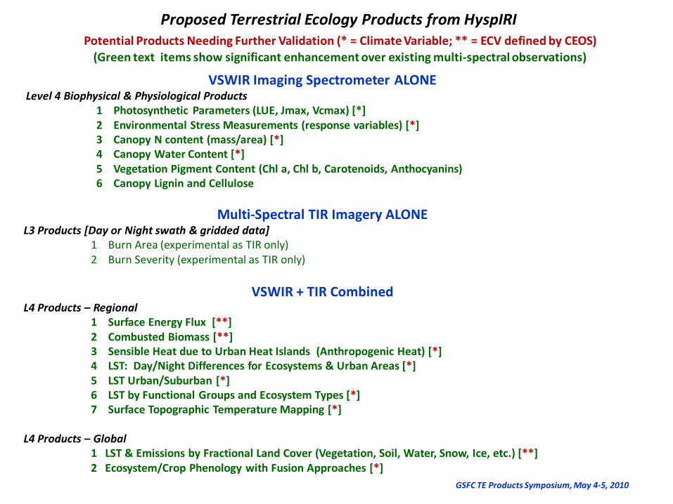
Proposed Terrestrial Ecology Products from HyspIRIPotential Products Needing Further Validation (* = Climate Variable; ** = ECV defined by CEOS)
(Green text items show significant enhancement over existing multi-spectral observations)
VSWIR Imaging Spectrometer ALONELevel 4 Biophysical & Physiological Products
1 Photosynthetic Parameters (LUE, Jmax, Vcmax) [*]2 Environmental Stress Measurements (response variables) [*]3 Canopy N content (mass/area) [*]4 Canopy Water Content [*]5 Vegetation Pigment Content (Chl a, Chl b, Carotenoids, Anthocyanins) 6 Canopy Lignin and Cellulose
Multi-Spectral TIR Imagery ALONEL3 Products [Day or Night swath & gridded data]
1 Burn Area (experimental as TIR only)2 Burn Severity (experimental as TIR only)
VSWIR + TIR CombinedL4 Products – Regional
1 Surface Energy Flux [**]2 Combusted Biomass [**]3 Sensible Heat due to Urban Heat Islands (Anthropogenic Heat) [*]4 LST: Day/Night Differences for Ecosystems & Urban Areas [*] 5 LST Urban/Suburban [*]6 LST by Functional Groups and Ecosystem Types [*]7 Surface Topographic Temperature Mapping [*]
L4 Products – Global1 LST & Emissions by Fractional Land Cover (Vegetation, Soil, Water, Snow, Ice, etc.) [**]2 Ecosystem/Crop Phenology with Fusion Approaches [*]
GSFC TE Products Symposium, May 4-5, 2010

AGENDA – DAY 2 (May 5)8:00 - 8:20 am: Coffee and donuts, Posters
8:30 -8:40 am: Review of Day 1 [Betsy]
VII. Related Activities to HyspIRI Mission
8:40 – 9:00 am: 2 Presentations on 2009 Funded HyspIRI Preparatory Studies
[Petya Campbell, Phil Townsend]
9:00 – 9:15 am: International collaborations, ISIS & WGCV [Rob Green]
9:15 – 9:35 am: A Mission Calibration Plan to support Products
[Kurt Thome/Rob Green/Simon Hook]
9:35 – 10:10 am: Synthesis of the Three Break-out Group Inputs (10 min each)
[Phil/John, Simon/Kurt, Dar/Susan]
10:10 -10:30 am: Coffee Break & Posters