Embed Size (px)
Citation preview

ISSN: 2319-9822
Citation: Haas GJ, Saunders WR, Miller JS, et al. Three-Sided Pyramidal Formation in the Western Region of Candor Chasma. J Space
Explor. 2017;6(3):133
© 2017 Trade Science Inc. 1
Three-Sided Pyramidal Formation in the Western Region of Candor Chasma
Haas GJ1*
, Saunders WR2, Miller JS
3 and Dale MA
4
1The Cydonia Institute, PO Box 102, Purcellville, Virginia, USA
2The Cydonia Institute, Wilson St. 412, Penticton, British Columbia, V2A 8J3, Canada
3The Cydonia Institute, PO Box 102, Purcellville, Virginia 20132, USA
4The Cydonia Institute, 2225 W Natchez St., Broken Arrow, Oklahoma 74011, USA
*Corresponding author: Haas GJ, The Cydonia Institute, PO Box 102, Purcellville, Virginia, USA, Tel: +1 215-898-
5000; E-mail: [email protected]
Received: October 04, 2017; Accepted: October 23, 2017; Published: October 27, 2017
Introduction
On May 30, 1971 the Mariner 9 spacecraft was launched from Cape Canaveral Air Force Station and reached the planet Mars
on November 14. After months of delays caused by annoying dust storms the spacecraft was eventually able to send back
over 7, 000 images of the Martian surface [1]. One image taken of the Elysium area appeared to include a three-sided
pyramidal formation (FIG. 1.) that caught the attention of world renowned astronomer Carl Sagan. Sagan, intrigued by the
shape of the pyramidal structure, presented the image at the Royal Institution in London during his Christmas Lecture in 1977
[2]. He also featured the image in his 1980 book and television series Cosmos in which he made the following comment;
“The largest Mars Pyramids have a base width of 3 km and a height of 1 km, so they are much larger than the Pyramids of
Sumer, Egypt and Mexico. With the ancient eroded shape, they could be small hills, sandblasted for centuries, but they need
to be viewed from nearby [3].
Abstract
A three-sided pyramidal formation located within the Candor Chasma region of Mars is examined. The formation is presented in
five NASA images provided by the Mars Global Surveyor (MGS) and Mars Reconnaissance Orbiter (MRO) spacecraft. The
images reveal defining aspects of the formations three-sided Reuleaux geometry, exposing a uniform symmetry in its three,
triangular faces. A geologist and a geoscientist examine natural mechanisms that could contribute to the creation of the pyramidal
formation and a claim of intelligent construction is proposed. An extensive search of comparable regions within and beyond the
area of Candor Chasma was conducted and terrestrial comparisons are also offered. A request for additional images is
recommended and a broader study of this anomalous formation is encouraged.
Keywords: Candor chasma; Cydonia; Mound; Pyramid; Reuleaux geometry; Mars global surveyor; Mars reconnaissance orbiter

www.tsijournals.com | October-2017
2
FIG. 1. Three-sided pyramidal formation. Elysium area of Mars. Mariner 9 image 4205-78, 1972, detail.
Experimental
Between 1976 and 1980 the Viking I and Viking II orbiters obtained images and data of the Martian surface that covered the
entire planet [4]. One image in particular captured in 1976 of the Cydonia region, Viking frame 70A13, [5] showed an
anomalous mesa with a unique pentagonal-shape (FIG. 2a) that caught the attention of two NASA scientists, DiPietro and
Molenaar [6]. Titled the D&M Pyramid, after their discovery, the formation appears to express a remarkable set of common
surface angles. The team remarked that “of all the observations of pyramids on Mars, we find that this one is the most
unusual” [7]. On May 1, 1980 they presented their findings at a press conference held at the Ramada Inn hotel in Lanham
Maryland [8] As a result they were invited to present their work in June at the Annual Convention of the American
Astronomical Society in College Park, Maryland [7].
It would be over twenty-five years before a second image of the D&M formation was taken by the Mars Odyssey THEMIS
camera in 2002 (FIG. 2b). The THEMIS image (20020413a) is a higher resolution image that revealed a clearer view of the
formation’s pyramidal shape and surface angles. After reviewing the THEMIS image an electrical engineer and digital
imaging specialist Dr. Mark Carlotto proposed that the formation exhibits evidence of artificial design. He concluded the
pyramidal formation is highly symmetrical and shows uniform faces measuring approximately 30°, 60° and 90° [9].

www.tsijournals.com | October-2017
3
FIG. 2. D&M Pyramid. Left: Detail Viking image 70A13 (1976). Courtesy NASA/JPL/The Cydonia Institute.
Right: Detail THEMIS 20020413a (2002). Proposed geometrical model overlaid (inverted). Courtesy
Mark J Carlotto.
In early June of 2002 independent researcher Wilmer Faust presented an image of a three-sided pyramidal formation in the
Candor Chasma region of Mars obtained in Mars Global Surveyor (MGS) image E06-00269 [10] to the first three authors of
this paper (FIG. 3). Faust directed our attention to a pyramidal formation with an almost circular base that had three
triangular-shaped faces.
FIG. 3. Three-sided pyramidal formation, Detail MOC E0600269 (2002) Image courtesy Wil Faust/MSSS.
Mgs images of the three-sided pyramid
The original image for this study was obtained via NASA’s Mars Global Surveyor web site. The Mars Global Surveyor
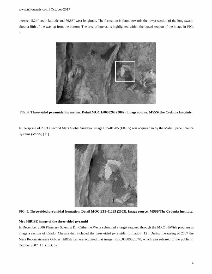
image E0600269 was acquired during June of 2001[10]. The area examined is located in the Candor Chasma region of Mars
www.tsijournals.com | October-2017
4
between 5.24° south latitude and 76.83° west longitude. The formation is found towards the lower section of the long swath,
about a fifth of the way up from the bottom. The area of interest is highlighted within the boxed section of the image in FIG.
4.
FIG. 4. Three-sided pyramidal formation. Detail MOC E0600269 (2002). Image source: MSSS/The Cydonia Institute.
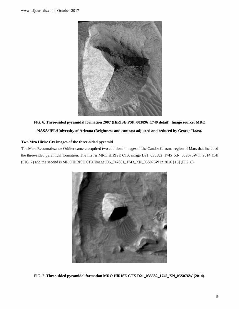
In the spring of 2003 a second Mars Global Surveyor image E15-01285 (FIG. 5) was acquired in by the Malin Space Science
Systems (MSSS) [11].
FIG. 5. Three-sided pyramidal formation. Detail MOC E15-01285 (2003). Image source: MSSS/The Cydonia Institute.
Mro HiRISE image of the three-sided pyramid
In December 2006 Planetary Scientist Dr. Catherine Weitz submitted a target request, through the MRO HiWish program to
image a section of Candor Chasma that included the three-sided pyramidal formation [12]. During the spring of 2007 the
Mars Reconnaissance Orbiter HiRISE camera acquired that image, PSP_003896_1740, which was released to the public in
October 2007 [13] (FIG. 6).
www.tsijournals.com | October-2017
5
FIG. 6. Three-sided pyramidal formation 2007 (HiRISE PSP_003896_1740 detail). Image source: MRO
NASA/JPL/University of Arizona (Brightness and contrast adjusted and reduced by George Haas).
Two Mro Hirise Ctx images of the three-sided pyramid
The Mars Reconnaissance Orbiter camera acquired two additional images of the Candor Chasma region of Mars that included
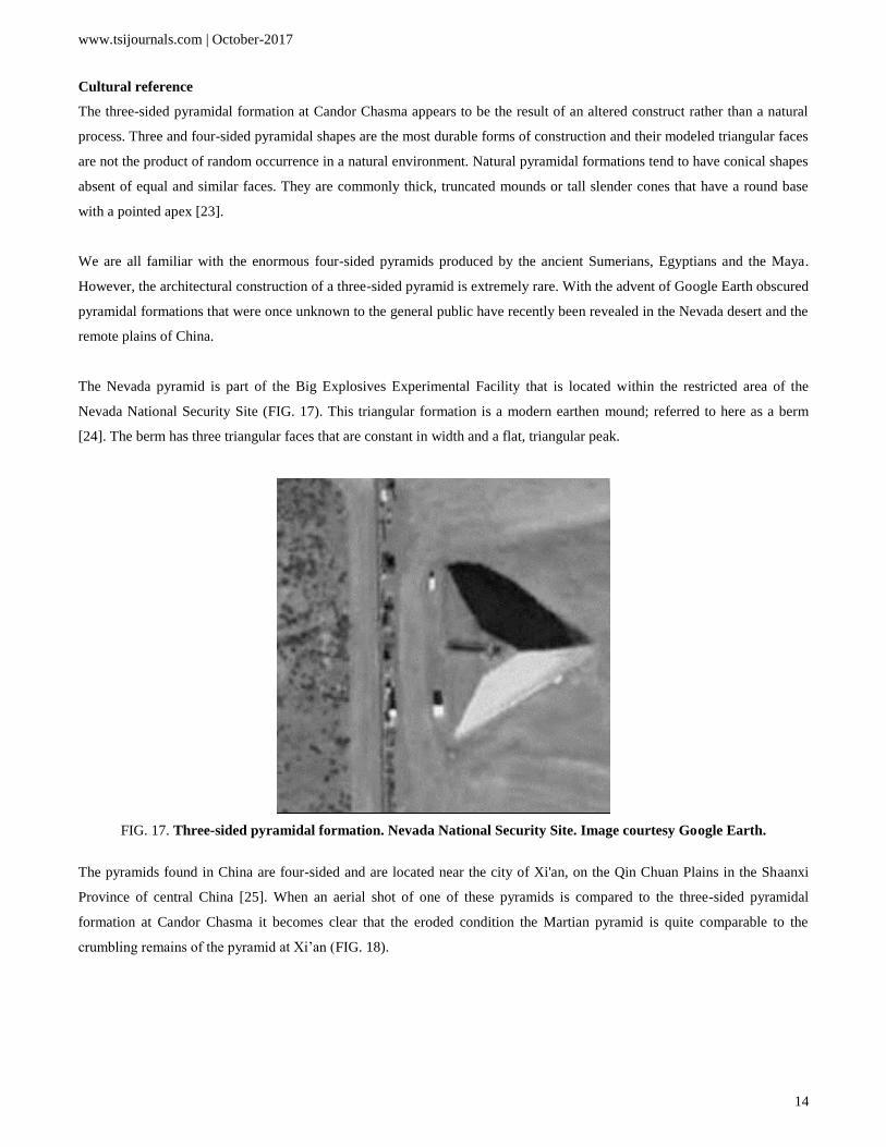
the three-sided pyramidal formation. The first is MRO HiRISE CTX image D21_035582_1745_XN_05S076W in 2014 [14]
(FIG. 7) and the second is MRO HiRISE CTX image J06_047081_1743_XN_05S076W in 2016 [15] (FIG. 8).
FIG. 7. Three-sided pyramidal formation MRO HiRISE CTX D21_035582_1745_XN_05S076W (2014).

www.tsijournals.com | October-2017
6
FIG. 8. Three-sided pyramidal formation MRO HiRISE CTX J06_047081_1743_XN_05S076W (2016).
Mgs and Mro ancillary data: Sun and camera angles
There are considerable differences in the telemetry, sun angle, resolution and other factors recorded in the five images; a
comparison chart is presented as TABLE 1. The three-sided, pyramidal shape of the formation persists throughout the five
images and additional features that were obscured in the first two MGS images are now visible in the MRO HiRISE images.
All images are presented as they were provided through those sites to the general public with only minor size and contrast
adjustments.
The first Mars Global Surveyor image E06-00269 was acquired on July 4, 2001 and released to the public on May 7, 2002.
The image was taken during the summer in the late evening (10:05 PM) with a resolution of 5.73 meters per pixel (FIG. 4).
The sun comes in from the west, illuminating the western face of the formation, exposing its triangular shape. The
northeastern face is slightly shaded while the southeastern face appears in soft shadow. A second Mars Global Surveyor
image of the formation E15-01285 was acquired during the spring season in the late morning hours (6:07 AM) of April 24,
2002 and not released until almost a year later on April 4, 2003 with a resolution of 6.00 meters per pixel (FIG. 5). The sun
illuminates the western face of the formation while the northeastern and southeastern faces have an even tonality.
The Mars Reconnaissance Orbiter HiRISE image that included the three-sided pyramidal formation, PSP_003896_1740, was
taken during the spring in the late afternoon (3:16 PM) on March 7, 2007 and released on October 10, 2007 with a resolution
of 25 centimeters per pixel (FIG. 6). The sun illuminates the western face of the formation, causing long shadows across the
north-eastern side, while muting the tone of the south-eastern side. All of the images in this study reveal defining aspects of
the formations three-sided geometry, exposing a uniform symmetry in its surrounding faces.
The first Mars Reconnaissance Orbiter HiRISE CTX image, D21_035582_1745_XN_05S076W, was acquired on February
28, 2014. The image was taken during the winter, in the early morning hours (2:11 AM) with a resolution of 5.29 meters per
pixel (FIG. 7). The sun illuminates the western face of the formation causing the southeastern side to appear in total darkness,
highlighting the triangular shape of its face. The second Mars Reconnaissance Orbiter HiRISE CTX image,
J06_047081_1743_XN_05S076W, was acquired on August 12, 2016. It was taken during the summer in the early morning

www.tsijournals.com | October-2017
7
hours (1:11 AM) with a resolution of 5.3 meters per pixel (FIG. 8). The sun illuminates the western face of the formation
while the northeastern and southeastern faces appear evenly shadowed.
TABLE 1. Ancillary data for Mars global surveyor, Mars reconnaissance orbiter HiRISE and CTX.
Image # E060269 E15-01285 PSP_003896_174
0
D21_035582_1745_X
N_05S076W
J06_047081_1743_XN_05S
076W
Acquisition
Date 04-Jul-01 24-Apr-02 27-May-07 28-Feb-14 12-Aug-16
Release Date 07-May-
02 04-Apr-03 10-Oct-07 NA NA
Local Time 10:05.8P
M 6:07:01AM 3:16PM 2:11AM 1:11AM
Image scale 5.73
m/pixel 6.00 m/pixel 26.0cm/pixel 5.29m/pixel 5.3m/pixel
Longitude 76.83˚W 76.73˚W 283.5˚E 283.4˚E 283.49˚E
Latitude 5.24˚S 6.04˚S 5.8˚S 5.59˚S 5.73 ˚S
Emission Angle 0.16˚ 17.79˚ 0.8˚ 3.31˚ 4.89˚
Incidence
Angle 40.56˚ 22.70˚ 50˚ 57.98˚ 50.91˚
Phase Angle 40.50˚ 23.03˚ 49.6˚ 55.46˚ 55.8˚
North Azimuth 93.02˚ 93.05˚ 97˚ 277.09˚ 277.05˚
Range to
Target 381. km 399.10km 260.1km NA NA
Image Skew
Angle NA NA NA 90.1˚ 90.2˚
Sun Azimuth 2.96˚ 20.87˚ 155.00˚ 221.64˚ 179.57˚
Results and Discussion
The geological context for the three-sided pyramidal formation
West Candor Chasma is part of the vast canyon system of the Valles Marineris region of Mars. It is located just below the
equator in the western hemisphere between 5° and 7° south and 75° and 77° west (FIG. 9). The canyon is bordered on the
north and south sides by straight-walled cliffs. Evidence of landslides are common on the north side forming reentrants filled
with debris while the southern wall shows “spur-and-gully morphology” along with smooth sections. The western side of the
canyon is defined by two cliffs extending toward the north and northeast [16]. Alteration of the canyon’s interior consist of
layered deposits of basaltic flow material, hummocky material, landslide deposits, possible geothermal processes [17] and
mass wasting.

www.tsijournals.com | October-2017
8
FIG. 9. Candor Chasma, Mola data map. Notated with the approximant location of the three-sided pyramid formation
(circle). Image courtesy NASA/JPL/Malin Space Science Systems/The Cydonia Institute.
Topography and morphology for the tree-sided pyramid
The purpose of this segment is to assess the geometry of the three-sided, pyramidal formation in question and determine what
natural processes are needed to create its form and structure. The feature is located within a canyon in the southwestern
section of Candor Chasma. The regional overview provided in the Mars Orbital Camera (MOC) image E06-00269 (FIG. 4)
and E15-01285 (FIG. 5) reveals the formation is positioned within the canyon floor with flow patterns of dark material in a
southeastern direction from the west and south faces of the pyramid. The size of the formation is approximately 49 pixels in
diameter, which is equal to 290 meters (5.84 meters per pixel). That is 951.44 feet or just under 1/5th of a mile across and
approximately 145 meters high or 476 feet. The sun comes from the left and the formation is seen from almost directly
overhead.
The first MOC image E0600269 (FIG. 10a) displays the most symmetry of the four images. With the aid of an analytical
drawing the arching curvature of the base can be seen on all three sides and its exposed faces are curved while the angles are
clearly defined and intersect along a straight edge. The three faces of the formation consist of three equally spaced triangles
that meet around a central vertex forming interior angles of 120 degrees equaling a total of 360 degrees. The east and west
sides show bilateral symmetry with identical right-angle triangles fitting within its configuration (FIG. 10a). When accessing
an analytical drawing of the second MRO imagine PSP_003896_1740 (FIG. 10b) we see similar symmetry due in part to the
almost straight overhead camera angle that is very close to the original MOC image E0600269 (FIG. 10a). The MRO image
(FIG. 10b) shows an arching base line along the western and southeastern sides while the western face of the formation
appears to be smoother than the other two faces. This is possibly due to the direct sun light coming in from the west. The
northeastern face demonstrates evidence of some erosion that graduate to the left edge of the pyramid.

www.tsijournals.com | October-2017
9
FIG. 10. Analytical drawings of the three-sided pyramidal formation. Left: Image source: MOC image E0600269
(2002). Right: Image source: MRO HiRISE image PSP_003896_1740 (2007). Analytical drawings by George J Haas.
The area of study for this section of the analysis is the approximate 1750 meters by 2450 meters visible in the E0600269
MOC image. No larger regional analysis is included here. Two large ridges, marked A and B in FIG. 11 trend in a general
north – south direction but gently arc in opposite directions. The ridges have sharp apexes with nearly continuous linear
extent. A few small, ridges of limited extent are highlighted in red to indicate their multi-directional makeup. This would
indicate the area was geophysically active at some point with extensive, multi-directional fracturing and faulting. The
heterogeneous appearance of the area within the white dashed lines is likely the result of a mass debris flow.
FIG. 11. Three-sided pyramidal formation (MOC E0600269-detail). Notations by William Saunders.
Image source: MSSS/The Cydonia Institute.
The pyramid feature is flanked to the northwest and southeast by what appears to be Aeolian sands. The shallow rise on the
north-northeast side of the ridge dunes indicate saltation and wind direction from that general direction. This may account for
some of the blowout found on the northeast side of the pyramid structure and may have aided as source material for some of

www.tsijournals.com | October-2017
10
the transverse Aeolian sand deposition marked C1, C2, C3 and C4. These dunes appear to be multi-directional in C1 and
relatively linear in C2 and C3. The deposition of the dunes marked C4 are multi-directional due to the underlying surface
features, however is very inconsistent in its coverage. The pyramidal structure marked 1, 2 and 3 has three ridge lines
forming three faces two of which have smooth surfaces. The north face marked number 1 has an uneven surface with
evidence of material having broken away and lying at the base. This collapse must be relatively recent due to the sharp
uneroded edges and none of the darker, wind-blown material appears to be present as seen in C4. The structure of dune
development on either side of the pyramidal feature shows the wind direction from the north-northeast. What is unusual is
that there are no wind streaks around the south buttress of the pyramidal structure such as seen in FIG. 12a.
As observed in Viking Orbiter image VO-553A54 [18] of the Hesperia Planum region of Mars (FIG. 12a) wind has caused
bright depositional streaks to form on the leeward side of an object. This feature would be expected to be absent in the
exposed areas around the three-sided formation and found within the V-shaped area in FIG. 10b.
a b
FIG. 12. Wind streaks. a) Craters with bright depositional streaks (Viking VO-553A54, detail). Image source: Lunar
and Planetary Institute, Houston, TX. b.) Three-sided formation (HiRISE PSP_002841_1740 detail). Image source:
MRO NASA/JPL/University of Arizona (Brightness and contrast adjusted and reduced by George Haas). Notation by
William Saunders.
The arching curvature of the base line of the three-sided pyramid at Candor Chasma forms a Reuleaux pyramid. The three-
sided formation has three vertices with curved faces that are constant in width between points a, b and c (FIG. 13a). The
vertices labeled a, points in a south-western direction, while the vertices labeled b points in a north-western direction and the
vertices labeled c points east. Its three faces can be formed by the intersection of three circular disks, each having its center
on the boundary of the other two. The imprint of an isosceles triangle is created between the vertices at points, a, b and c.
showing that the north base, between point b and c is shorter than the other two sides (FIG. 13b). While measurements placed
upon a two-dimensional image cannot be expected to be accurate we can gather some information from the exercise. We note
that we do indeed have two equal faces of the pyramid, within the western side and the southeastern side while the third
northeastern face is degraded. We also readily see that the base of the formation is rounded; this is evident even through the
debris fan on the north side, between point b and c, expands beyond the actual base outline.

www.tsijournals.com | October-2017
11
a b
FIG. 13. Geometric study of three-sided pyramidal formation. a) Reuleaux pyramid Image source: MRO HiRISE
image PSP_003896_1740 (2007). b) Isosceles triangle Image source: MOC image E0600269 (2002)
Analytical drawing by George J Haas.
Mountains are formed in three ways, through volcanism, plate tectonics (folding) and block faulting. The geomorphology of
the three-sided pyramidal formation observed at Candor Chasma is an enigma. It has none of the characteristics of these
known processes. It stands alone in its location and form.
Mars, like Earth, hosts an extensive sedimentary record of mound creation. However, the origin of sedimentary mounds on
Mars is a major unresolved question [19]. A member of the Department of Geophysical Sciences, Edwin S. Kite at the
University of Chicago, Chicago, Illinois has proposed two working models for how Martian mounds may have been formed
[20]
The first model includes craters and canyons that are fully filled by flat-lying or shallowly dipping strata with playa-deposits
or fluvio-deltaic deposits that are exposed to extensive erosion by the effects of wind erosion over long periods of time. The
model suggests that main cause of non-horizontal layer-orientations is caused by soft-sediment deformation, tectonics and
differential compaction [20].
The second model shows the downslope layer-tilts are primary. It proposes that mounds grew in place by net deposition of
layers on preexisting topographic highs. This distinctively Martian mechanism is suggested by that growth of polar
ice/dust/sand mounds by anticompensational stacking. It notes the importance of aeolian sediment transport and slope-winds
on modern Mars and the strong inference of layered sediment accumulation via anticompensational stacking for some Mars
equatorial layered sediments. The model reveals that dry conditions bring aeolian processes to the fore, whereas vigorous and
sustained fluvial erosion would inhibit mound construction [20].
Kite concludes that anticompensational stacking corresponds to a paleoenvironment where fluvial sediment transport is
infrequent and consistent with models of Mars paleoclimate [20]. Examining the three triangular faces of this pyramidal
formation (FIG. 14) in the MRO HiRISE orbiter image, which has a resolution of 25 centimeters per pixel, the southern face
appears to be formed by firm, compact soil. The northern face is degraded and crumbling into its base. The western face

www.tsijournals.com | October-2017
12
appears to be composed of a smooth consolidated material. It also contains horizontal layering indicative of sedimentary
stratigraphy at the lower portion of the formation.
FIG. 14. Three-sided pyramidal formation showing possible sedimentary strata (MRO HiRISE PSP_003896_1740
detail, 2007). Image source: MRO NASA/JPL/University of Arizona (Insert and contrast adjustment by George
Haas).
If this layered feature is indeed evidence for sedimentary strata one has to wonder how lacustrine or marine deposition could
have been eroded away in the entire area leaving a highly symmetrical three-sided mountain in its wake. The strata also
demonstrate a consistent thickness indicating that perhaps they are not depositional material but may actually be the remnants
of casing stones [21] used in construction of the pyramidal formation.
Presented with a pyramidal formation at Candor Chasma that has been exposed to an extensive period of environmental
forces that have potentially caused the erosion and degradation of its original form, this formation exhibits remarkable
symmetry. Symmetry, in nature, is found in biological systems whereas inanimate objects exposed to environmental forces
trend towards random and asymmetrical forms.
Comparable pyramidal formation on Mars
Looking directly across from the three-sided pyramid, in MOC image E15-01285, on the western side of the strip is a wedge-
shaped mound with a triangular peak (FIG. 15). The western face of the three-sided pyramid is in direct alignment with the
wedge-shaped mound. The structural form of the wedge-shaped mound appears eroded and half buried at the base of a dense
ridgeline that sets within a highly textured terrain (FIG. 15).

www.tsijournals.com | October-2017
13
FIG. 15. Wedge-shaped formation with triangular peak. MOC E15-01285 Detail (2003). Image source: MSSS/The
Cydonia Institute.
When the geometry of the three-sided pyramidal formation observed in the Candor Chasma region of Mars (FIG. 3) is
compared to the proposed pentagonal geometry of the D&M pyramid, located in the Cydonia region of Mars (FIG. 2), both
formations exhibit remarkable symmetry. The interior design of the D&M pyramid contains angles measuring approximately
30°, 60° and 90° that suggest the faces can be described by isosceles and right triangular facets. Although both formations
present a high degree of bilateral symmetry they show signs of erosion and degradation and are not complete. The three-sided
pyramid formation at Candor Chasma lacks a clearly defined third face at its base (FIG. 3) while the D&M pyramid at
Cydonia (FIG. 2) shows a difference between the left and right "arms" of the formation and its eastern side appears collapsed
[9].
In March 2002 a circular mound with a three-sided pyramidal form was photographed in the southern region of Cydonia, not
far below the D&M Pyramid. The Mars Global Orbiter image MOC E14-00508 [22] (FIG. 16a) shows a three-sided
formation with a curvature base line that is constant with an equilateral triangle and all points on each face are of equal
distant from the opposite vertex conforming to the geometry of a Reuleaux pyramid (FIG. 16b). The geometry of the Cydonia
formation is consistent with the three-sided pyramidal formation at Candor Chasma (FIG. 13).
a b
FIG. 16. Cydonia three-sided pyramid formation. a) Detail of MOC image E14-00508 (2002). b) Reuleaux diagram.
www.tsijournals.com | October-2017
14
Cultural reference
The three-sided pyramidal formation at Candor Chasma appears to be the result of an altered construct rather than a natural
process. Three and four-sided pyramidal shapes are the most durable forms of construction and their modeled triangular faces
are not the product of random occurrence in a natural environment. Natural pyramidal formations tend to have conical shapes
absent of equal and similar faces. They are commonly thick, truncated mounds or tall slender cones that have a round base
with a pointed apex [23].
We are all familiar with the enormous four-sided pyramids produced by the ancient Sumerians, Egyptians and the Maya.
However, the architectural construction of a three-sided pyramid is extremely rare. With the advent of Google Earth obscured
pyramidal formations that were once unknown to the general public have recently been revealed in the Nevada desert and the
remote plains of China.
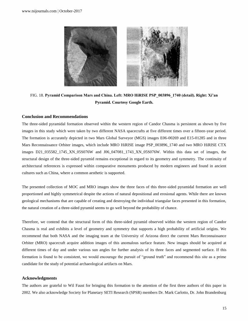
The Nevada pyramid is part of the Big Explosives Experimental Facility that is located within the restricted area of the
Nevada National Security Site (FIG. 17). This triangular formation is a modern earthen mound; referred to here as a berm
[24]. The berm has three triangular faces that are constant in width and a flat, triangular peak.
FIG. 17. Three-sided pyramidal formation. Nevada National Security Site. Image courtesy Google Earth.
The pyramids found in China are four-sided and are located near the city of Xi'an, on the Qin Chuan Plains in the Shaanxi
Province of central China [25]. When an aerial shot of one of these pyramids is compared to the three-sided pyramidal
formation at Candor Chasma it becomes clear that the eroded condition the Martian pyramid is quite comparable to the
crumbling remains of the pyramid at Xi’an (FIG. 18).
www.tsijournals.com | October-2017
15
FIG. 18. Pyramid Comparison Mars and China. Left: MRO HiRISE PSP_003896_1740 (detail). Right: Xi’an
Pyramid. Courtesy Google Earth.
Conclusion and Recommendations
The three-sided pyramidal formation observed within the western region of Candor Chasma is persistent as shown by five
images in this study which were taken by two different NASA spacecrafts at five different times over a fifteen-year period.
The formation is accurately depicted in two Mars Global Surveyor (MGS) images E06-00269 and E15-01285 and in three
Mars Reconnaissance Orbiter images, which include MRO HiRISE image PSP_003896_1740 and two MRO HiRISE CTX
images D21_035582_1745_XN_05S076W and J06_047081_1743_XN_05S076W. Within this data set of images, the
structural design of the three-sided pyramid remains exceptional in regard to its geometry and symmetry. The continuity of
architectural references is expressed within comparative monuments produced by modern engineers and found in ancient
cultures such as China, where a common aesthetic is supported.
The presented collection of MOC and MRO images show the three faces of this three-sided pyramidal formation are well
proportioned and highly symmetrical despite the actions of natural depositional and erosional agents. While there are known
geological mechanisms that are capable of creating and destroying the individual triangular faces presented in this formation,
the natural creation of a three-sided pyramid seems to go well beyond the probability of chance.
Therefore, we contend that the structural form of this three-sided pyramid observed within the western region of Candor
Chasma is real and exhibits a level of geometry and symmetry that supports a high probability of artificial origins. We
recommend that both NASA and the imaging team at the University of Arizona direct the current Mars Reconnaissance
Orbiter (MRO) spacecraft acquire addition images of this anomalous surface feature. New images should be acquired at
different times of day and under various sun angles for further analysis of its three faces and segmented surface. If this
formation is found to be consistent, we would encourage the pursuit of “ground truth” and recommend this site as a prime
candidate for the study of potential archaeological artifacts on Mars.
Acknowledgments
The authors are grateful to Wil Faust for bringing this formation to the attention of the first three authors of this paper in
2002. We also acknowledge Society for Planetary SETI Research (SPSR) members Dr. Mark Carlotto, Dr. John Brandenburg

www.tsijournals.com | October-2017
16
and Ananda Sirisena for their comments and suggestions in regard to reviewing earlier drafts of this paper. Special thanks go
to NASA and the University of Arizona for the use of the Mars Global Surveyor and Mars Reconnaissance Orbiter images
that are available on their public web sites.
REFERENCE
1. Parks RJ. Mariner 9 and the exploration of Mars. Astronautical Research. 1972;1973:149-62.
2. Sagan C. The Planets, Mars before Viking, Christmas Lecture, Royal Institution, BBC 2; 1977.
3. Sagan C. Cosmos. Published by Random House, New York City, New York, United States;1980;129:130.
4. Viking 1 and 2. NASA Mars Exploration. Program & Missions. 1975.
5. http://viewer.mars.asu.edu/planetview/inst/viking/070A13#P=070A13&T=2
6. DiPietro V, Molenaar G. Unusual Martian Surface Features' Mars Research, Glen Dale, Maryland; 1982.
7. Carlotto M. The Cydonia Controversy, Lulu.com; 2008;p:47.
8. Boeche R. Journal of the Fortean Research Center Paperbound; 2012.
9. Carlotto MJ. Analysis of Mars Odyssey THEMIS Imagery of the "D&M Pyramid." New Frontiers in Science.
2002;1(3):4.
10. http://www.msss.com/moc_gallery/e01_e06/images/E06/E0600269.html
11. http://www.msss.com/moc_gallery/e13_e18/images/E15/E1501285.html
12. https://www.uahirise.org/hiwish/view/8360
13. http://hirise.lpl.arizona.edu/PSP_003896_1740
14. http://viewer.mars.asu.edu/planetview/inst/ctx/D21_035582_1745_XN_05S076W#P=D21_035582_1745_XN_05S0
76W&T=2.
15. http://viewer.mars.asu.edu/planetview/inst/ctx/J06_047081_1743_XN_05S076W#P=J06_047081_1743_XN_05S07
6W&T=2.
16. http://mars.jpl.nasa.gov/gallery/canyons/PIA00403.html.
17. Geissler PE, Singer RB, Komatsu G et al. An unusual spectral unit in West Candor Chasma: Evidence for aqueous
or hydrothermal alteration in the Martian canyons. Icarus. 1993;106:380-91.
18. http://www.lpi.usra.edu/publications/slidesets/winds/winds_index.shtml
19. Grotzinger JP, Milliken RE. The Sedimentary Rock Record of Mars: Distribution, Origins and Global Stratigraphy.
Sedimentary Geology of Mars SEPM Special Publication. 2012;102:1-48.
20. Kite ES, Sneed J, Mayer DP, et al. Evolution of major sedimentary mounds on Mars: build-up via
anticompensational stacking modulated by climate change. J Geophys Res. 2016;121(11):2282-24.
21. Hoagland RC. It Only Takes ONE White Crow: The Real Agenda of NASA's Curiosity Mars Rover Mission,
Enterprise Mission; 2013.
22. http://www.msss.com/moc_gallery/e13_e18/images/E14/E1400508.html
23. Scientific American: Supplement, the formation of mountains by water, the influence of erosion by water in
modeling the landscape, New York; 1911.
24. https://wci.llnl.gov/
25. Preston S. Who Made the Pyramids? Lulu Press, Inc. Morrisville, North Carolina, United States; 2014.