Embed Size (px)
Citation preview

Page 1 of 24
U. S. Department of the Interior
U. S. Geological Survey
The Timan-Pechora Basin Province of Northwest ArcticRussia: Domanik – Paleozoic Total Petroleum System
On-Line Edition
by
Sandra J. Lindquist1
Open-File Report 99-50-G
This report is preliminary and has not been reviewed for conformity with the U.S.Geological Survey editorial standards or with the North American Stratigraphic Code.Any use of trade names is for descriptive purposes only and does not imply endorsementby the U.S. government.
1999 1 Consulting Geologist, Contractor to U. S. Geological Survey, Denver, Colorado

Page 2 of 40
The Timan-Pechora Basin Province of Northwest Arctic Russia:Domanik – Paleozoic Total Petroleum System2
Sandra J. Lindquist, Consulting GeologistContractor to U.S. Geological Survey, Denver, CO
March, 1999
FOREWORD
This report was prepared as part of the World Energy Project of the U.S. GeologicalSurvey. In the project, the world was divided into eight regions and 937 geologicprovinces. The provinces have been ranked according to the discovered oil and gasvolumes within each (Klett and others, 1997). Then, 76 "priority" provinces (exclusiveof the U.S. and chosen for their high ranking) and 26 "boutique" provinces (exclusive ofthe U.S. and chosen for their anticipated petroleum richness or special regional economicimportance) were selected for appraisal of oil and gas resources. The petroleum geologyof these priority and boutique provinces is described in this series of reports. The Timan-Pechora Basin Province ranks 22nd in the world, exclusive of the U.S.
The purpose of this effort is to aid in assessing the quantities of oil, gas, and natural gasliquids that have the potential to be added to reserves within the next 30 years. Thesevolumes either reside in undiscovered fields whose sizes exceed the stated minimum-field-size cutoff value for the assessment unit (variable, but must be at least 1 millionbarrels of oil equivalent) or occur as reserve growth of fields already discovered.
The total petroleum system constitutes the basic geologic unit of the oil and gasassessment. The total petroleum system includes all genetically related petroleumoccurring in shows and accumulations (discovered and undiscovered) that has beengenerated by a pod or by closely related pods of mature source rock and that exists withina limited mappable geologic space, together with the essential mappable geologicelements (source, reservoir, seal, and overburden rocks) that control the fundamentalprocesses of generation, expulsion, migration, entrapment, and preservation ofpetroleum. The minimum petroleum system is that part of a total petroleum systemencompassing discovered shows and accumulations, together with the geologic space inwhich the various essential elements have been proved by these discoveries.
An assessment unit is a mappable part of a total petroleum system in which discoveredand undiscovered fields constitute a single relatively homogenous population such thatthe chosen methodology of resource assessment – based on estimation of the number andsizes of undiscovered fields – is applicable. A total petroleum system might equate to asingle assessment unit. If necessary, a total petroleum system may be subdivided intotwo or more assessment units such that each assessment unit is sufficiently homogeneous 2 Domanik-Paleozoic Total Petroleum System (#100801), northwestern Russia and southern Barents Sea,Timan-Pechora Basin Province (#1008), Former Soviet Union (Region 1)

Page 3 of 40
in terms of geology, exploration considerations, and risk to assess individually.Assessment units are considered established if they contain more than 13 fields, frontierif they contain 1-13 fields, and hypothetical if they contain no fields.
A graphical depiction of the elements of the a total petroleum system is provided in theform of an events chart that shows the time of deposition of essential rock units; the timein which processes (such as trap formation) necessary to the accumulation ofhydrocarbons took place; the critical moment in the total petroleum system; and thepreservation time, if any.
A numeric code identifies each region, province, total petroleum system, and assessmentunit; these codes are uniform throughout the project and will identify the same item inany of the publications. The code is as follows: Example
Region, single digit 3Province, three digits to the right of region code 3162Total Petroleum System, two digits to the right of province code 316205Assessment unit, two digits to the right of petroleum system code 31620504
The codes for the regions and provinces are listed in Klett and others, 1997.
Oil and gas reserves quoted in this report are derived from the Petroleum Exploration andProduction database (Petroconsultants, 1996) and other reports from Petroconsultants,Inc., unless otherwise noted.
Figure(s) in this report that show boundaries of the total petroleum system(s), assessmentunits, and pods of active source rocks were compiled using geographic informationsystem (GIS) software. Political boundaries and cartographic representations weretaken, with permission, from Environmental Systems Research Institute's ArcWorld 1:3million digital coverage (1992), have no political significance, and are displayed forgeneral reference only. Oil and gas field centerpoints, shown on this(these) figure(s), arereproduced, with permission, from Petroconsultants, 1996.
ABSTRACT
The Domanik-Paleozoic oil-prone total petroleum system covers most of the Timan-Pechora Basin Province of northwestern Arctic Russia. It contains nearly 20 BBOEultimate recoverable reserves (66% oil). West of the province is the early PrecambrianEastern European craton margin. The province itself was the site of periodic Paleozoictectonic events, culminating with the Hercynian Uralian orogeny along its eastern border.The stratigraphic record is dominated by Paleozoic platform and shelf-edge carbonatessucceeded by Upper Permian to Triassic molasse siliciclastics that are locally present indepressions. Upper Devonian (Frasnian), deep marine shale and limestone source rocks –with typically 5 wt % total organic carbon – by middle Mesozoic time had generatedhydrocarbons that migrated into reservoirs ranging in age from Ordovician to Triassic butmost focused in Devonian and Permian rocks. Carboniferous structural inversions of oldaulacogen borders, and Hercynian (Permian) to Early Cimmerian (Late Triassic to EarlyJurassic) orogenic compression not only impacted depositional patterns, but also createdand subsequently modified numerous structural traps within the province.

Page 4 of 40
INTRODUCTION
One major total petroleum system characterizes the Timan-Pechora Basin Province in theArctic coastal region of northwestern Russia. The source rocks are basinal faciesequivalents to shelf-edge reefs ranging in age from Late Devonian (Frasnian) to earliestCarboniferous (Tournaisian). Although similar conditions existed again in Early Permiantime, the richest and most volumetrically important source rocks are Frasnian in age andare called “Domanik.” Limited mixing is likely from at least two other petroleumsystems within or adjacent to this province. A Siluro-Ordovician source rock ispostulated to exist in the eastern part of the province (Adzva-Varandey Zone and Kosyu-Rogov Trough, Figure 1), with at least four fields identified as containing somehydrocarbons thus generated. The northern part of the province along the coastal regionmight also contain mixed hydrocarbons from the generation of and migration fromTriassic source rocks offshore in the Barents Sea. Portions of the Timan-Pechoraoffshore with potential Triassic-sourced hydrocarbons will be discussed further in theSouth Barents Sea Province evaluation. Not addressed in this review and assessment areunconventional gas reserves are present in coaly siliciclastics of Artinskian andKungurian age of the Timan-Pechora foredeep regions (Ben Law, U.S. GeologicalSurvey, personal communication).
References listed in this report include a limited selection of those most recent and mostpertinent to this document. Not all are specifically cited in the text. The stratigraphicequivalents chart is composited from many references to approximately equate the rangeof stratigraphic nomenclature in use. It is not intended to be precise with respect toabsolute geologic age.
PROVINCE GEOLOGY
Province Boundary and Geographic Setting
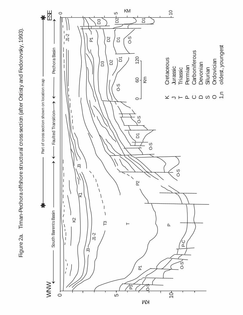
The Timan-Pechora Basin Province overlies the Arctic Circle, extending across 61°-72°north latitude and 44°-66° east longitude (Figure 1). To the east, outside the provinceboundary, is a sinuous fold belt including the Ural Mountains, the Pay-Khoy Ridge,Vaygach Island and the Novaya Zemlya archipelago. To the west is the NW-SE trendingTiman-Kanin Ridge, which intersects the Ural Mountains at the southern end of theprovince. The northern offshore province boundary is the South Barents transitional faultzone, separating the excluded South Barents basin of the Barents Sea from the includedPechora block within the Pechora Sea (Figure 2a). Onshore geologic features are knownto extend offshore. Onshore area (70%) of this province is 315,100 sq km (121,629 sqmi) and includes the drainage basins of the Pechora, Usa, and Izhma Rivers. Offshore(30%) are 131,700 sq km (50,836 sq mi), of which approximately 5,400 sq km (2,084 sqmi) comprise islands.
Political Entities
The Timan-Pechora Basin Province is entirely within the Russian Federation of theformer Soviet Union, but Russia is divided into political units with different legislative

PEC
HO
RA
- KO
LVA
AU
LAC
OG
EN
@
Ural Mountains
Tim
an -
Kani
n R
idge
N
100 km
Korotaikha Trough
Kosyu - Rogov Trough
Ch
erno
v Swell
ChernyshovSwell
Soro
kin
Swel
l
Khoreyver
Depression
Kol
va
Sw
ell
Pec
hora
Koz
hva
Sw
ell
Den
isov Dep
ress
ion
Bolshesyna
Trough
Izhma -
Pechora
Depression
Upper
Pechora
Trough
East
Tim
an
S
wel
l
Omra-SoyvaStep
Vukty
lSw
ellM
icha
yu-P
ashn
ya S
wel
l
Makarik
ha-
Salyukin
Gam
burt
sev
Swel
l
Lay
Sha
pkin
o-Y
urya
kha
Adzva-
Zone
Pech
ora
River
Pech
ora
Riv
erPay-Khoy Ridge
Nova
ya-Z
emly
a
Vaygach
IslandKara Sea
Pechora Sea
Barents Sea
KolguyevIsland
KaninPeninsula
Seduyakha
Sw
ell
West Siberia
Sw
ell
Swell
Sw
ell
F O R
E D
E E
P
B A S I N S
Figure 1. Location map for Timan-Pechora Basin and Province.
Structural regions after Ulmishek, 1982;Lobkovsky and others,1996; and Ivanova, 1997.
Arctic Circle MalayaZemlyaMonocline
Izhma R
iver
Usa River
Ukhta
Varandey
60o 65o
70o
70o
65o
50 55o o
40 45o o
o65
RiversShorelineProvince BoundaryCountry BorderField Centerpoints
@
@
@
@
Pechora
Naryan- Mar
Vorkuta
@ Towns
Figure 2a
X-Section
Figure 2b
X-section
Figure 2cX-Section
Normal FaultsThrust Faults
Offshore Highs
o
NorthPole
GREENLAND
BARENTS SEA
Siberia
NORTH AMERICA
EURASIA
Laptev Sea
Kara Sea
Scandinavia
Nordic Sea
Iceland
Baffin Bay
Baffin Is.
Cana
dian
Arc
tic
I
sland
s
CanadaAlaska
Chukchi Sea
Bering
Sea
1000 km
180
0
90 E
90 W
o
o
o
o
Index map
EXPLANATION
*
* Location ofFigure 8burial historyplot
Fig
ure
2a.
T
iman
-Pec
ho
ra o
ffsh
ore
str
uct
ura
l cro
ss s
ecti
on (a
fter
Ost
isty
an
d F
edo
rovs
ky, 1
993)
.
Part
of c
ross
sec
tio
n s
ho
wn
on
loca
tio
n m
ap
WN
WPe
cho
ra B
asin
Sou
th B
aren
ts B
asin
ESE
Fau
lted
Tra
nsi
tio
n
K
Cre
tace
ou
sJ
Jura
ssic
TTr
iass
icP
Perm
ian
C
Car
bo
nife
rou
sD
D
evo
nia
nS
Silu
rian
O
Ord
ovi
cian
1,n
o
ldes
t, yo
un
ges
t
0
60
120
Km
KM 1050
KM0 105
J1-2
P1
D3 D2
D1
D2
D1
O-S
D3 D2 D
1O
-S
O-S
D1
O-S
O-S
J3
P2
K1
K2
J3J1
-2
T3 T P
P-C
O-S
O-S
P1
P3

Page 7 of 40
and jurisdictional responsibilities. Most of Timan-Pechora is within the Komi republic –which includes most of the known current production – but large fields yet to bedeveloped are within the Nenets Autonomous Okrug of Arkhangel’sk Oblast (Sagers,1994).
Geologic Setting
The Timan-Pechora Basin Province is on the Pechora crustal plate (late Proterozoicbasement) northeast from the margin of the Precambrian (Archean to early Proterozoic)Eastern European craton. The area periodically was the site of Proterozoic rifting andcontinental suturing (Bashilov and Kuprin, 1995; Bogatsky and others, 1996),approximately parallel with the Timan Ridge that borders the province to the southwest(Figures 1, 2b, 2c). During periods of collision, a subduction zone and volcanic arcsystem existed offshore to the northeast.
The Timan Ridge includes accreted and uplifted, slightly metamorphosed basement. Ithas been a west-verging thrust complex (Sobornov and Rostovshchikov, 1996) andperhaps even a left-lateral wrench zone (Ulmishek, 1988; Mezhvilk, 1995). Faultsseparating the Timan Ridge from the easterly adjacent Izhma-Pechora Depression have0.5-0.8 km offsets (Bogatsky and others, 1996).
Baikalian (Riphean-Vendian) basement of the Timan Ridge uplift and the Izhma-PechoraDepression is relatively homogeneous and rigid. Basement in the Pechora-KolvaAulacogen and regions eastward (Figure 1) changes to that of active margin andtransitional crust (Bogatsky and others, 1996), with greater compositional heterogeneitythat resulted in repeated fault activation and structural inversion through time. Thus, thePechora-Kolva Aulacogen and the Adzva-Varandey Zone (also a possible aulacogen)contain shallow structures discordant with those at basement level (Figures 1 and 2b).Old aulacogen borders are marked with shallow anticlines known as the Pechora-Kozhva,Shapkino-Yuryakha, Kolva, Sorokin, and Chernov Swells. The Lay and Bolshezemelskbasement arches are masked by overlying shallower basins (Denisov and KhoreyverDepressions, respectively). Basement crops out in the Timan Ridge and Ural Mountains,but attains 12-14 km depths in eastern foredeep basins bordering the western side of theUral and Pay-Khoy / Novaya Zemlya fold belts.
After latest Proterozoic plate collision (post-Riphean, pre-Vendian “Baikalian Orogeny”),the Timan-Pechora region was a passive continental margin for much of the followingPaleozoic era, with episodes of Ordovician and Devonian rifting (Driscole and Golden,1995; Dedeyev and others, 1996; Sobornov and Rostovshchikov, 1996; Ismail-Zadeh andothers, 1997) (Figure 3). Paleozoic cratonic landmasses were to the west-southwest, withthe Uralian Ocean to the east-northeast. Earliest Paleozoic basin fill gradually changedfrom siliciclastic- to carbonate-dominated. Upper Ordovician evaporites were depositedin the eastern parts of the province (Tarbayev and others, 1991; Stepanova, 1994).
Significant Middle Devonian aulacogen rejuvenation (Pechora-Kolva, possiblyVarandey-Adzva, Figure 1) was concurrent with basaltic volcanism and the appearanceof siliciclastics locally from the west. Eastward prograding, major shelf-edge reef

2 4 6 8 10 12S.L.
S.L. 2 4 6 8km
020
40
60
Ho
rizo
nta
l Sca
le
UR
AL
MTS
.
K
OSY
U-
R
OG
OV
FOR
EDEE
P
CH
ER
NY
SH
OV
RID
GE
BO
LSH
EZEM
ELSK
A
RC
H
LAY
SWEL
L
KH
OR
EYV
ERD
EPR
ESSI
ON
KO
LVA
SWEL
L
DEN
ISO
VD
EPR
ESSI
ON
PEC
HO
RA
- K
OZ
HV
A S
WEL
L
P
E
C
H
O
R
A
- K
O
L
V
A
A
U
L
A
C
O
G
E N
IZH
MA
-PEC
HO
RA
D
EPR
ESSI
ON
TIM
AN
RID
GE
CA
RB
ON
ATE
RO
CK
S
SILI
CIC
LAST
IC R
OC
KS
FAU
LTS
HY
DR
OC
AR
BO
N A
CC
UM
ULA
TIO
NS
WN
WES
E
Fig
ure
2b
. T
iman
-Pec
ho
ra n
ort
her
n o
nsh
ore
str
uct
ura
l cro
ss s
ecti
on
(aft
er U
lmis
hek
, 198
2).
Mz
Mes
ozo
icP
2 P
erm
ian
, up
per
P1
Per
mia
n, l
ow
erC
C
arb
on
ifero
us
D3
Dev
on
ian
, up
per
D2
Dev
on
ian
, mid
dle
D1
Dev
on
ian
, lo
wer
S
Silu
rian
O
Ord
ovi
cian
km
Shapkino Swell
P1-C
SO
D1
D2
S
D1
D2
D3
Mz
P-C
O-S
D3
O
D2
Mz
P C
SD
3D
S
P2 -
P1 P1 -
C
D S O
P1 CBa
sem
ent
Base
men
tBa
sem
ent
Base
men
t
km

0 2 4 6 8Km
Fig
ure
2c.
T
iman
-Pec
ho
ra s
ou
ther
n o
nsh
ore
str
uct
ura
l cro
ss s
ecti
on
(aft
er D
edee
v an
d o
ther
s, 1
994)
.
Izh
ma-
Pech
ora
Dep
ress
ion
Tim
an R
idg
eU
pp
er P
ech
ora
Tro
ug
h
Lo
wer
Pro
tero
zoic
Bas
emen
t
Up
per
Pro
tero
zoic
Bas
emen
tO
O
D
D
SC
P
PC
T &
J
P2
T P1 C DS
P C D3
WE
JJu
rass
icT
Tria
ssic
PPe
rmia
nC
C
arb
on
ifero
us
D
Dev
on
ian
SSi
luri
anO
O
rdo
vici
an1,
n
old
est,
youn
ges
t
Km

GEOLOGIC TIME PERIODSMa
TERTIARY
CRE
TAC
EOU
S
JURASSIC
TRIASSIC
PERMIAN
CARBON-IFEROUS
DEVONIAN
SILURIAN
ORD
OV
ICIA
NC
AM
BRIA
N
PRE-CAMBRIAN
5
1020
30405060
7080
90
100
110
120
130
140
150
160
170
180
190
200
210
220
230
240
250
260
270
280
290
300
310
320
330
340
350
360
370
380
390
400
410
420
430
440
450
460
470480
490
500
510
520530
540550
560
570
38002500
ProterozoicArchean
Pre-Archean
Vendian, Riphean
Lower
Middle
Upper
Lower
Middle
Upper AshgillCaradocLlandeiloLlanvirn
Arenig
Tremadoc
Lower
Upper
Lower
Middle
Upper
Lower
Middle
Upper
Lower
Upper
Mid / Lower
Upper
Lower(Lias)
Middle(Dogger)
Upper(Malm)
Neocomian
Senonian
Paleogene
Neogene
QUATERNARY Holocene / Pleistocene
Pliocene
Miocene
Oligocene
Eocene
PaleoceneMaastrichtian
CampanianSantonian / Coniacian
Turonian / Cenomanian
Albian
Aptian
Barremian
Hauter / Valang / Berrias
TithonianKimmeridgian / Oxfordian
Callov / Bathon / Bajoc
Aalenian
Toarcian / Pliensbachian
SinemurianHettangian
Rhaetian / Norian
Carnian
Lad / An / Sp / Na / Gr
Tartarian / KazanianUfmian
Kungurian / Artinskian
Sakmarian
Asselian
Gzelian / Kasimovian
MoscovianBashkirian
Serpukhovian
Visean
Tournaisian
FamennianFrasnian
Givetian / Eifelian (Couvin)
Emsian / Pragian (Siegen)
Lochkovian (Gedinnian)
Pridoli / LudlowWenlock
Llandovery
Naryanmar
Shapkina, Charkabozh
Berezovka, Paemboy
Vorkuta, Yun'-Yakha
Myachkov, Podol, Kashir, Verey
Oka, Protvin
Yasnopolyan (Tula, Bobrikov)Malinov
Dankov/Lebedyan, Zadonsk/Yeletsk
Chib'yu (middle and lower Devonian)
Vaskerk
Shchugor
Khydey
TelposIzhma-Omra
Sed
yol
Nibel
Kungurian evaps more abundant to south
1 see above
2 see above
3 see above
SEE CARB - DEV BELOW
1. Chernyshin, Likhvin, Kizelov, Cherepet, Dzhebol, Zelenets, Etroeungtian
2. Ukhta (Yevlanov-Liven), Sirachoy (Voronezh), Vetlasyan, Mendym, Buregi, * Domanik/Semiluki, Sargay, Kynov, Pashiy
3. Starooskol, Afonin, Biysk, Koyva (Kaltseol), Vayzov, Vanyashkin, Takatin
S
SS
S
S
S
S
S
S
SS
S
S
S
S
S
S
S
S
SS
C
C
CE
C
C
C
S
S
S
S
SE
M
CR
CR
C
C
C
S
SSES
CRCR
C
C
C
CE
CE
C
Cr*
Cr*CR*S
CE
CE
CE
CE
S S
C C
C CCR*S CR*S
S S CM
CR
CR
CR
CR
C
C
C
C
C
CC
C
C
C
CE
CE
CE
SSSS S
SSM
s
s
S
STRATIGRAPHICNOMENCLATURE
MAJORLITHOLOGY
Wes
t A
rea:
Tim
an, I
zhm
a-Pe
cho
ra
Cen
tral
Are
a: P
ech
ora
-Ko
zhva
to
Var
and
ey-A
dzv
a
East
Are
a: U
ralia
n fo
red
eep
bas
ins
pres
ent o
ffsh
ore
to th
e no
rth
and
nort
heas
t
Lower Jurassic siliciclastics present offshore to the north and northeast
Note that "central" area has local variability indepositional recordand tectonic history.
GEOLOGIC EVENTS
S Y
N
A
N D
P O
S T
H E
R C
Y N
I A
N( E
a s
t e
r n
P r
o v
e n
a n
c e
)L
A T
E
P A
L E
O Z
O I
CE
A R
L Y
P A
L E
O Z
O I
C( W
e
s
t e
r
n
P
r
o v
e
n
a n
c
e )
recent Uralian uplift
Bare
nts S
ea su
bsid
ence
Early Cimmerian Orogeny (Pay Khoy - Novaya Zemlya)
Hercynian Orogeny(Ural Mts.)
basalticvolcanism
basalticvolcanism
perio
dic a
ulac
ogen
inve
rsio
ns
aulacogenrejuvenation
(in N. Barents Sea)Caledonian Orogeny
early rifting, opening of Uralian Ocean
basement age - Timan-Pechora
basement age - Russian platformNot present
EXPLANATIONS SiliciclasticsC CarbonatesM Mixed S + C
E EvaporitesR Reefs, organic buildupsletter not capitalized signifies less importanceunconformity
* Domanik source-rock facies (basinal shales and carbonates)
Figure 3. Chart of generalized stratigraphy for the Timan-Pechora Basin Province.
Baikalian Orogeny

Page 11 of 40
systems bordered elongate, restricted intrashelf basins where rich organic matter waspreserved (“Domanik” facies). During the following Carboniferous Period, structuralinversions again were associated with localized influxes of siliciclastics and precipitationof evaporites (Lower Carboniferous, Figure 3), but Tournaisian reefs were less extensivethan Upper Devonian varieties.
By Permian time, the Hercynian Orogeny brought compression from the east, thrustingslope and deep marine rocks over their shelf counterparts and creating the proto-UralMountains and their molasse-filled foredeep basins. Timan-Pechora’s major provenanceeventually changed to an easterly sourced, siliciclastic-dominated style. Structuralinversions, combined with sea-level fluctuations, resulted in complex facies distributionsand periods of erosion. Major Early Permian shelf-edge reefs proliferated, and asubsequently continuous subsidence began in the Barents Sea Basin to the north. Timan-Pechora Triassic and later sedimentation became largely continental in the southernregions.
The Pay-Khoy / Novaya Zemlya fold belt and its foredeep basins were created in LateTriassic to Early Jurassic time (Early Cimmerian Orogeny), post-dating formation of theUral foldbelt. The compressional eastern boundary of the Timan-Pechora Basin Provincewas most recently uplifted again in late Tertiary time, but that Neogene deformation waslargely restricted to the eastern mountain margin bordering western Siberia (Sobornovand Rostovshchikov, 1996). Overall, the Timan-Pechora Basin is filled with 55-60%carbonates, 35-40% siliciclastics and about 5% evaporites (Dedeev and others, 1994).
Exploration History
Over time, the focus of Timan-Pechora oil and gas exploration migrated from thesouthwestern part of the province – where seeps abound and permafrost is rare – to thenortheastern region where the land is swampier and lower in elevation and has year-round permafrost. The entire province is characterized with extreme cold temperatures,and not all fields produce regularly. New joint ventures have been established withWestern industry.
The presence of oil near Ukhta in the southwestern part of the Timan-Pechora BasinProvince was known as early as 1595, and between 1869 and 1917, thirty non-commercial shallow wells were drilled in the area (Meyerhoff, 1980). Fourclassifications of wells (new-field wildcats, exploratory, outpost and development)account for 98% of the 3,878 additional wells drilled in the province through 1995(Petroconsultants, 1996). The remaining 2% include service wells, water wells and“stratigraphic” tests. The first commercial oil field (Chib’yu) was discovered in 1930 andthe first commercial gas field (Sed’yol) in 1935.
Unfortunately, spud or completion dates are not available for 62% of the well population,but Figure 4 illustrates from the known population the significant amount of drilling thatbegan in the mid 1940s (most early wells classified as outposts) and has continued topresent. In recent years, the numbers of wells categorized as new field wildcats and

0510152025303540
1930
1932
1934
1936
1938
1940
1942
1944
1946
1948
1950
1952
1954
1956
1958
1960
1962
1964
1966
1968
1970
1972
1974
1976
1978
1980
1982
1984
1986
1988
1990
1992
1994
New
Fie
ld W
ildca
tEx
plo
rato
ryO
utp
ost
Dev
elo
pm
ent
Co
mp
leti
on
Yea
r
Fig
ure
4.
Nu
mb
ers
of W
ells
Dri
lled
in th
eTim
an-P
ech
ora
Bas
in P
rovi
nce
* D
ata
for 3
2% o
f all
wel
ls d
rille
d (6
8% h
ave
n
o s
pu
d o
r co
mp
leti
on
dat
es a
vaila
ble
).
Dat
a fr
om
Pet
roco
nsu
ltan
ts, 1
996.

Page 13 of 40
exploratory wells have increased relative to those classified as outposts and developmentwells.
PETROLEUM OCCURRENCE
Geographic and Stratigraphic Location
Oil seeps and tar sands are common in the Timan-Pechora Basin, even withinPrecambrian (Riphean) rocks of the Timan Ridge (Sobornov and Yakovlev, 1996).Petroconsultants (1996) lists 257 fields within the province (Table 1), but 31 fields haveno production or reserve data published. For the Timan-Pechora Basin Province, knownultimate recoverable reserves of nearly 20 BBOE are distributed as 66% oil, 30% gas and4% condensate. Five fields are significantly distant from the mainland (Figures 1 and 5).The two northernmost fields on Kolguyev Island are likely associated with a differentpetroleum system in the offshore South Barents Sea Basin (Table 1).
Foredeep basins on the east side of the Timan-Pechora Basin Province are gas dominated,as are both the southwesternmost area along the Timan Ridge and the northern coastalregion of the Shapkino-Yuryakha and Lay Swells (northern part of Pechora-KolvaAulacogen, Figure 1). The southern foredeep (Upper Pechora Trough) contains theprovince’s largest field – Vuktyl, with nearly 50% of the province’s known recoverablegas – but northeastern foredeep basins (Kosyu-Rogov and Korotaikha) are sparselyexplored. The northern Izhma-Pechora Depression contains few fields despite havingapproximately 100 well penetrations. Offshore Timan-Pechora has both oil and gasfields, and fewer than a dozen offshore exploratory wells have been drilled away fromislands.
Hydrocarbons are trapped in Ordovician through Triassic reservoir rocks at 200 to 4500meter depths (Kiryukhina, 1995). Scenarios for multi-stage hydrocarbon migrations andremigrations are possible, particularly in the Ural foredeeps, because of regionallyvariable burial history and the province’s repeated tectonism (Bogatsky and Pankratov,1993). Most oil is reservoired in tectonically stable areas with stratigraphic traps(Bogatsky and Pankratov, 1993). Conversely, most gas (alone or with oil) is in activetectonic areas where more recent gas charging could have occurred. Late CenozoicUralian uplift probably resulted in cooling and decompression of formation fluids,allowing gas to come out of solution and accumulate in traps (Sobornov andRostovshchikov, 1996).
Geochemistry of Hydrocarbons
Timan-Pechora hydrocarbons range from high gravity, low sulfur and low resin oils withparaffin bases to low gravity, high sulfur and high viscosity oils of dominantly aromatic-napthenic compositions (Kiryukhina, 1995). Sulfur content is related to the presence ofevaporites, and Kosyu-Rogov (foredeep basin) gases contain H2S. Commonly, oils instratigraphically older reservoirs have lower density, fewer asphaltenes and more residualcomponents than those in stratigraphically younger reservoirs (Meyerhoff, 1980).Biodegradation occurs in shallow accumulations. Province-wide, oil gravity ranges from11°-62° API and condensate gravity from 45°-79°API (Petroconsultants, 1996). From


Page 13 of 24
in Upper Ordovician evaporites create more complex structural deformation in theKosyu-Rogov and Korotaikha foredeeps to the northeast.
Structural inversion on the margins of the Pechora-Kolva and Varandey-AdzvaAulacogens began by middle Carboniferous time and continued intermittently throughoutthe Hercynian and Early Cimmerian orogenies. Such activity ultimately createdanticlines with as much as 1000 meters of relief (Schamel and others, 1992; Schamel andothers, 1994). Numerous, large producing fields – including the two largest oil fields inthe province, Usa and Vozey – produce from these anticlinal trends. The Pechora-KolvaAulacogen is also prospective where it projects southeastward under the Uralianforedeep.
Shallow structural closures in the more stable Izhma-Pechora Depression have 20-100meter amplitudes, and one of the largest closures there is 4x20 km in area (Ulmishek,1982). Paleozoic and Early Mesozoic stratigraphic and combination traps against oldnormal faults, paleo-horsts, and several basement arches (e.g., Bolshezemelsky Arch, LaySwell) are expected throughout the province (Dedeev and others, 1994; Aleksin andothers, 1995; Sobornov and Yakovlev, 1996).
A summary of the distribution of oil and gas by reservoir horizon and by lithology is inTable 2. “Reservoir age” is the top of the reservoir interval reported by Petroconsultants(1966). Forty-two percent of the known recoverable reserves cannot be allocated easily tospecific strata, based on available data, but pre-Hercynian upper Paleozoic reservoirs(Middle to Upper Devonian and Lower Permian) apparently account for the bulk ofproducible hydrocarbons. Ulmishek (personal communication, 1999) believes thatproductive capability from Middle Devonian siliciclastics is significantly under-represented in the table and perhaps captured within the “Upper Devonian” category.From the Petroconsultants allocatable data, carbonates would outproduce sandstones 54%to 46% in known recoverable volumes.
Stratigraphic-pinchout and normal-fault traps were created as early as Ordovician timeduring the opening of the Uralian Ocean and then again with aulacogen formation orrejuvenation during the Devonian period (Figure 6). Some 150 m.y. of subsequentperiodic structural inversion continuously created new structural traps, destroyed others,and impacted sedimentation patterns, culminating in the Hercynian and Early Cimmerianorogenies (Figure 3). The regionally varying times of hydrocarbon generation(Carboniferous to Jurassic) overlapped the Late Paleozoic to Early Mesozoic tectoniccycle of trap formation and destruction. Dedeev and others (1994) believe that just 2-3%of all generated hydrocarbons remain trapped in the Timan-Pechora Basin.
Discovery History
The first commercial Timan-Pechora oil discovery, Chib’yu field, with basal Frasnian(upper Devonian) Pashiy sandstone reservoirs, was in 1930. Two years later, heavy oil(19° API) was discovered at nearby shallow Yarega field in Middle Devonian sandstones,which have been exploited by shaft mining and steam injection since 1939. Yaregacurrently is the 6th largest field in the Timan-Pechora Basin Province with respect to

Page 14 of 24
ultimate recoverable reserves (Petroconsultants, 1996). In 1934, 240 km farther northeastnear the town of Pechora, Yugid field was discovered with oil in Lower Carboniferoussandstones.
First commercial gas, also in Devonian sandstones, was discovered in Sed’yol field, nearUkhta, in 1935. The largest province gas field, Vuktyl, was discovered in 1964 inPaleozoic carbonates of the southern Ural foredeep and has nearly 18 TCF in originalreserves (Meyerhoff, 1980). Seven fields exceed 0.5 BBOE in ultimately recoverablereserves (Petroconsultants, 1996), and they were discovered in the following sequence,listed by decreasing size: #1 Vuktyl, 1964; #2 Usa, 1963; #3 Vozey, 1971; #4 Kharyaga,1977; #5 Layavozh, 1969; #6 Yarega, 1932; and #7 Kumzhinskoye, 1975.
RESERVOIR ROCK
Identification and Description
Timan-Pechora reservoirs range in age from Upper Ordovician to Triassic (Table 2,Figure 6) and cover most of the province except for the northern Izhma-PechoraDepression to the west. The largest volume of reserves is in Middle/Upper Devoniansiliciclastics and Lower Permian carbonates. An early Paleozoic progression fromlimited continental to extensive marine depositional environments characterized theprovince, with a return to dominantly continental conditions by Late Permian andTriassic time. Offshore extensions of nearly all reservoir trends are underexplored.
Basal Ordovician siliciclastics are underexplored for deep structural and stratigraphictraps in what are now the Upper Pechora and Kosyu-Rogov foredeep basins and, ifpresent, within the Khoreyver Depression. Ordovician through Lower Devonianreservoirs average 10-30 meters in net thickness and are mostly carbonates in structuraland stratigraphic traps, focused in the southern Khoreyver Depression, the Adzva-Varandey Zone, and the Kosyu-Rogov Trough (Figures 1 and 2b).
Middle Devonian reservoirs are all unconformity-encased sandstones of westernprovenance, with an isopach thick extending from the Upper Pechora Trough northwardthrough the Pechora-Kolva Aulacogen (Ulmishek, 1982, 1988). They prolificallyproduce along sinuous trends where lithology changes – extending from the Omra Step,the southern Izhma-Pechora Depression and Upper Pechora Trough northward along theold Pechora-Kolva Aulacogen borders to a point south of the coastline (Figure 1). Faciesare more marine eastward, and isopachs reflect pre-Late Devonian erosion within thePechora-Kolva Aulacogen, where stratigraphic traps probably abound. Two fields arereported to produce from Middle Devonian strata within the Adzva-Varandey Zone(Petroconsultants,1996), although Ulmishek (personal communication, 1999) believesMiddle Devonian strata to be absent there. Middle Devonian net reservoir thicknessaverages 13 meters, with a maximum of 114 meters.
Overall, Upper Paleozoic reservoirs are carbonates over sandstones by nearly 2:1 involume of known ultimately recoverable reserves (Table 2). Net reservoir thicknessesaverage from 9 to 19 meters. Facies and play trends for these intervals are discussed and

Page 15 of 24
illustrated in Ulmishek (1982), Ulmishek (1988), Rostovshchikov and others (1991),Belyayeva (1992), Belyakov (1994), Zhemchugova and Schamel (1994), and Aleksin andothers (1995). Tectonically controlled Upper Devonian and Lower Permian shelf-edgereefs comprise the most significant carbonate plays, and the Domanik source rock faciesare the basinal age-equivalents to Upper Devonian reefs. Upper Devonian reservoirsoccur in a similar area to Middle Devonian reservoirs – but with more abundance in theeastern part of the province – and Upper Devonian reef reservoirs also extend across theKhoreyver Depression. Upper Devonian reservoirs are all sandstone on the westernmostedge of the province, mostly carbonate in the eastern region, and mixed carbonate andsiliciclastic across most of the Izhma-Pechora Depression and Pechora-Kolva Aulacogen.
Carboniferous reservoirs are limited in reserve-volume importance, but trend diagonallyacross the province from the southern Izhma-Pechora Depression and Omra Step regionnortheastward to the coastline at the Pechora-Kolva Aulacogen and Adva-VarandeyZone. Additional Carboniferous reservoirs have been discovered in the Kosyu-Rogovand Korotaikha foredeeps.
Lower Permian reservoirs delineate the largest area of any reservoir rock. They cover anonshore swath similar to the Carboniferous – from the southernmost tip of the province(mostly sandstone) to the most mountain-proximal foredeeps of Kosyu-Rogov andKorotaikha (carbonates) to the offshore (sandstone to the west, carbonate to the east).Kolguyev Island apparently marked the northeasternmost corner of the Paleozoic Timan-Pechora platform (Preobrazhenskaya and others, 1998).
Youngest Upper Permian and Triassic reservoirs (all sandstone and averaging 7 to 9meters net thickness) are located on anticlines of the northern Pechora-Kolva Aulacogen,the northern Sorokin Swell and offshore on Kolguyev Island (Figure 1). More productionapproximately overlies the Middle Devonian fairway – along the western-Uralianforedeep margin from just north of the Omra Step northeastward to the foredeep junctionwith the Pechora-Kolva Aulacogen. Upper Permian and Triassic sandstone genesisranges from fluvial-alluvial to marine in a SE-to-NW transect (Stupakova, 1992; Oknova,1993; Kuranova and others, 1998). The entire north-northeastern part of the province –including the Pechora-Kolva Aulacogen, the Khoreyver Depression, the KorotaikhaTrough, and the offshore extensions – could be prospective for Triassic stratigraphic andcombination traps (Dedeev and others, 1994).
Reservoir Properties
Timan-Pechora siliciclastic reservoirs average 16% porosity and 154 md permeability,and carbonate reservoirs average 13% porosity and 208 md permeability(Petroconsultants, 1996) (Table 2).
For sandstones, average reservoir porosities range from a low of 11.5 % in the LowerPaleozoic reservoirs to a high of 22.5% in Triassic counterparts. The range of maximumsandstone reservoir porosity is 12% (Lower Paleozoic reservoirs) to 28% (Triassicreservoirs). For carbonates, average reservoir porosities range from a low of 9 % in theLower Paleozoic reservoirs to a high of 15.8% in Lower Carboniferous counterparts. The

Page 16 of 24
range of maximum carbonate reservoir porosity is 10% (Lower Paleozoic carbonates) to28% (Lower Permian reef reservoirs).
For sandstones, average reservoir permeabilities range from a low of 15 md in the LowerPaleozoic reservoirs to a high of 372 md in Upper Devonian counterparts. The range ofmaximum sandstone reservoir permeability is 15 md (Lower Paleozoic reservoirs) to4000 md (Upper Devonian reservoirs). For carbonates, average reservoir permeabilitiesrange from a low of 63 md to a high of 930 md, both in Lower Paleozoic reservoirs. Therange of maximum carbonate reservoir permeability is 80 md (Lower Paleozoiccarbonates) to 1200 md (Upper Devonian reef reservoirs).
Hercynian orogenic siliciclastics are lithic-rich; thus, Triassic sandstones have somewhatlower average (75 md) and maximum (340 md) reservoir permeabilities than Paleozoicsandstones. Paleozoic carbonate reef reservoirs contain 53% of known ultimaterecoverable reserves (Table 2). Upper Devonian shelf-edge reef fronts are commonlydolomitized, and best reservoir properties are located near the slope break. Kuznetsov(1997) provides the example of Pashshor field where net/gross pay ratios vary from 67-90% in reef-front facies to 13-39% in back-reef facies. In contrast, Permian reefs havebest primary porosity preserved in stacked lenticular zones at the reef centers.
SEAL ROCK
A Late Paleozoic humid climate in this region contributed to the development of localand regional shale seals rather than evaporite seals (Kuznetsov, 1997). Upper Devonian(Lower Frasnian) Kynov and Sargay transgressive marine shales are commonly tens-of-meters thick. The Kynov Shale has a regionally unconformable relationship withunderlying strata of various ages over most of the Timan-Pechora Basin Province(Ulmishek, 1982). Upper Frasnian to Tournaisian Domanik source-rock facies andcarbonates with anhydrite beds, as thick as several hundred meters together, also providegood sealing potential.
Lower Permian (Artinskian to Kungurian) marine shales and evaporites range tohundreds of meters in thickness. Salt is present only in the southern Upper PechoraTrough. At Vuktyl field, anhydrite seals a 1.4-km gas column equal to the structuralclosure for the field (Sobornov and Rostovshchikov, 1996).
Syn-Hercynian Upper Permian and Triassic siliciclastics also contain adequate seals,particulary in marine and coastal shales (Zakharov and Kulibakina, 1997). Both theupper member of the Lower Triassic Charkabozh Formation and offshore marine shalesof Upper Jurassic to Lower Cretaceous age also are regional seals to several hundredmeters in thickness (Oknova, 1993).
ASSESSMENT UNITS
The Domanik-Paleozoic total petroleum system is somewhat smaller than the Timan-Pechora Basin geologic province (Figure 5), with 18.8% of the province excluded(84,000 sq km – all northern offshore waters). Three assessment units are designated to

Page 17 of 24
assess resource potential – N.W. Izhma-Pechora (#10080101), Main Basin Platform(#10080102), and Foredeep Basins (#10080103). For the purposes of this resourceassessment, no field-growth function will be utilized for data from this province becauseof some known cases of over-reporting of reserves (G.F. Ulmishek, personalcommunication).
N.W. Izhma-Pechora Assessment Unit #10080101
The northwestern portion of the Izhma-Pechora Depression (Figures 1 and 5) is ahypothetical assessment unit. It has no known fields and is outside of the known area ofactive source rock. N.W. Izhma-Pechora comprises 19.5% of the total petroleum systemand is approximately 70,600 sq km in size, with 10.5% of that area offshore. Seventy-five onshore wells have tested its area. Risks are increased relative to the Main BasinPlatform (discussed below) for source rock presence, migration routes, and the timing oftrap formation relative to migration.
Main Basin Platform Assessment Unit #10080102
This major producing area in the total petroleum system includes the original stableplatform areas of the province and the old aulacogen region(s) (Figures 1 and 5). It is anestablished assessment unit. The Main Basin Platform comprises 56.5% of the totalpetroleum system and is approximately 205,100 sq km in size, with 16.2% of that areaoffshore. It is distinguished from the following Foredeep Basins (#10080103) assessmentunit because of differences in burial history, trap types, and timing of trap formation asrelated to generation and migration/remigration (Figure 6).
Most significant structures onshore have been tested, but offshore areas are largelyunexplored. A greater emphasis on stratigraphic traps – alone or in combination withstructural enhancement – is expected for future field development and reserve additions,especially for the onshore areas. The following major trap types are discussed inUlmishek (1982) and Dedeev and others (1994). Lower Paleozoic carbonate andsiliciclastic rocks generally have an angular configuration, updip to the west, beneath theregional pre-Middle Devonian unconformity. Overlying Middle Devonian sandstones areeroded by the post-Middle Devonian unconformity and preserved in SSW-NNE trendsthat weave across this assessment unit (Figure 55 in Ulmishek, 1982).
Similarly, Upper Devonian to Tournaisian and Lower Permian carbonate build-ups havedelineated shelf-edge trends (Figure 56 in Ulmishek, 1982; Figure 1 in Rostovshchikovand others, 1991; Figure 1 in Belyayeva, 1992; Figure 4 in Belyakov, 1994; Figure 2 inZhemchugova and Schamel, 1994; Figure 1 in Aleksin and others, 1995 ; and Figure 1 inIvanova, 1997). Finally, Permo-Triassic stratigraphic and combination traps are bothknown and further expected.
Foredeep Basins Assessment Unit #10080103
The Foredeep Basin assessment unit is also established with production and comprises24% of the total petroleum system. It is approximately 87,100 sq km in size, with 8.7%

Page 18 of 24
of that area offshore. Trap styles in this assessment unit will be dominated by Uralianand Pay Khoy thrusted closures without surface expression, and sour gas is expected toconstitute a large portion of the resource base. Not included in this assessment processare unconventional gas accumulations (Ben Law, U.S. Geological Survey, personalcommunication) in Artinskian and Kungurian coaly siliciclastics of the foredeep region.
SELECTED REFERENCES
Abrams, M.A., Apanel, A.M., Timoshenko, O.M., and Kosenkova, N.N., 1999,Oil families and their potential sources in the northeastern Timan Pechora basin, Russia:American Association of Petroleum Geologists Bulletin, v. 83, no. 4, p. 553-577.
Aleksin, A.G., Khromov, V.T., Melik-Pasheva, N.V., and others (?), 1995,Lithologic and stratigraphic traps, Timan-Pechora oil-gas province: Petroleum Geology,v. 29, n. 1-2, p. 16-25 (translation from Poiski Zalezhey Nefti i Gaza v LovushkakhNeantiklinal’nogo Tipa: Moscow, Nedra, p. 137-146, 1985).
Alsgaard, P.C., 1992, Eastern Barents Sea Late Palaeozoic setting and potentialsource rocks, in Vorren, T.O., Bergsager, E., Dahl-Stamnes, O.A., Holter, E., Johansen,B., Lie, E., Lund, T.B., editors, Arctic geology and petroleum potential, NorwegianPetroleum Society (NPF) Special Publication No. 2: Amsterdam, The Netherlands,Elsevier Science Publishers B.V., p. 405-418.
Bashilov, V.I., and Kuprin, V.F., 1995, Relationship of oil and gas fields andshows to faults in the Timan-Pechora basin: Petroleum Geology, v. 29, n. 11-12, p. 370-373 (translated from Otechestvennaya Geologiya, no. 2, p. 16-21, 1995).
Bazhenova, T.K., 1995, Scale of oil and gas generation in the Timan-Pechorabasin, in Petroleum Exploration and Production in Timan-Pechora Basin and BarentsSea, collected reports of International Conference August 15-17, 1994: St. Petersburg,Russia, VNIGRI, p. 150-157.
Belonin, M.D., and Makarevich, V.N., 1995, Petroleum exploration andproduction in Timan-Pechora Basin and Barents Sea, Collected reports of Internationalconference August 15-17, 1994: St. Petersburg, All-Russian Petroleum ScientificResearch Geological Exploration Institute and Continental Shelf and petroleumTechnology Research Institute, 224 p.
Belyakov, S.L., 1994, Lower Permian paleostructural units of the Timan-Pechoraregion: Geotectonics, v. 28, no. 1, p. 33-43 (translation of Russian edition, also 1994).
Belyayeva, N.V., 1992, Effect of tectonic regime on the formation of upperDevonian reef zones of the Pechora platform: Petroleum Geology, v. 26, no. 9-10, p.318-324 (translated from Tektonika Severo-Vostoka Evropeyskoy platformy: Akad. NaukSSSR, Ural. Otdel., Komi Nauk Tsentr, Trudy Inst. Geol., no. 68, p. 60-72, 1988).

Page 19 of 24
Bogatsky, V.I., Bogdanov, N.A., Kostyuchenko, S.L., Senin, B.V., Sobolev, S.F.,Shipilov, E.V., and Khain, V.E., 1996, Explanatory notes for the tectonic map of theBarents Sea and the northern part of European Russia, scale 1:2,500,000: Moscow,Institute of the Lithosphere, Russian Academy of Sciences, 101 p.
Bogatsky, V., and Pankratov, J., 1993, Controls on the distribution of oil, gas, andgas-condensate pools in the Timan-Pechora basin (abs): American Association ofPetroleum Geologists Bulletin, v. 77, no. 9, p. 1608.
Bogdanov, B.P., Belyakov, C.L., Mikheyev, V.A., and Gerasimova, V.V., 1992,Non-anticlinal hydrocarbon traps in the Permian clastic sediments of the Pechora-Kolvinaulacogen: Petroleum Geology, v. 26, n. 5-6, p. 161-164 (translated fromNeftegazoperspektivnyye ob’yekty Timano-Pechorskoy provintsii i metody ikhprognozirovaniya: Leningrad, VNIGRI, p. 86-93, 1990).
Bro, Y.G., and others, 1990, Parametric wells on Kolguyev Island: PetroleumGeology, v. 24, no. 9-10, p. 294-298 (translated from Sovetskaya Geologiya, no. 3, p. 82-88, 1988).
Dedeev, V., Aminov, L., and Schamel, S., 1994, Stratigraphic distribution of oiland gas resources of the Timan-Pechora basin: International Geology Review, v. 36, p.24-32.
Dedeyev, V.A., Aminov, L.Z., Molin, V.A., and Yudin, V.V., 1993, Tectonicsand systematic distribution of deposits of energy resources of the Pechora platform:Petroleum Geology, v. 27, no. 9-10, p. 324-335 (translated from Aktual’nyye problemytektoniki SSSR, Nauka, p. 124-138, 1988).
Dedeyev, V.A., Aminov, L.Z., Malyshev, N.A., Pimenov, B.A., and Knyazhin,S.L., 1996, Rifting and oil-gas potential of the northeast of the European craton:Petroleum Geology, v. 30, n. 2, p. 153-159 (translated from Riftogeniz ineftegazonosnost’: Moscow, Nauka, p. 51-59, 1993).
Driscole, A., and Golden, M., 1995, Stratigraphy of the major hydrocarbonbearing basins, in Harrison, B., ed., Russian Style Formation Evaluation: London, TheLondon Petrophysical Society and The Geology Society, p. 19-63.
Environmental Systems Research Institute, Inc., 1992, ArcWorld 1:3M digitaldatabase: Environmental Systems Research Institute, Inc. (ESRI), available from ESRI,Redlands, CA, scale 1:3,000,000.
Ferriday, I.L., Borisov, A., Gudkova, A, Hall, P.B., Vinnikovsky, V., Bakken,K.A., and Bjoroy, M., 1995, Source rock potential and the characterization of finds in theRussian part of the Barents Sea, in Petroleum Exploration and Production in Timan-Pechora Basin and Barents Sea, collected reports of International Conference August 15-17, 1994: St. Petersburg, Russia, VNIGRI, p. 43-44.

Page 20 of 24
Hall, P.B., Ferriday, I.L., Borisov, A., Gudkova, A., Vinnikovsky, V., and Bjoroy,M., 1995, Geochemical analysis of oils and source rocks from the off-shore, northern partof the Timano-Pechora area, in Petroleum Exploration and Production in Timan-PechoraBasin and Barents Sea, collected reports of International Conference August 15-17, 1994:St. Petersburg, Russia, VNIGRI, p. 136-137.
Heafford, A., 1993, The geology of Palaeozoic hydrocarbons in the easternEuropean USSR and their relevance to the Barents shelf, in Vorren, T.O., Bergsager, E.,Dahl-Stamnes, O.A., Holter, E., Johansen, B., Lie, E., Lund, T.B., editors, Arctic geologyand petroleum potential, Norwegian Petroleum Society (NPF) Special Publication No. 2:Amsterdam, The Netherlands, Elsevier Science Publishers B.V., p. 261-271.
Ismail-Zadeh, A.T., Kostyuchenko, S.L., and Naimark, B.M., 1997, The Timan-Pechora basin (northeastern European Russia): tectonic subsidence analysis and a modelof formation mechanism: Tectonophysics, v. 283, p. 205-218.
Ivanova, N.M., 1997, Prospective Palaeozoic reefs in the southern part of theBarents Sea shelf: Petroleum Geoscience, v. 3, p. 153-160.
Johansen, S.E., Ostisty, B.K., Birkeland, O., Fedorovsky, Y.F., Martirosjan, V.N.,Bruun Christensen, O., Cheredeev, S.I., Ignatenko, E.A., and Margulis, L.S., 1993,Hydrocarbon potential in the Barents Sea region: play distribution and potential, inVorren, T.O., Bergsager, E., Dahl-Stamnes, O.A., Holter, E., Johansen, B., Lie, E., Lund,T.B., eds., Arctic Geology and Petroleum Potential, Norwegian Petroleum Society (NPF)Special Publication No. 2: Amsterdam, The Netherlands, Elsevier Science PublishersB.V., p. 273-320.
Kiryukhina, T.A., 1995, The types of oil in the Timan-Pechora basin: MoscowUniversity Geology Bulletin, v. 50., n. 2, p. 19-26.
Klett, T.R., Ahlbrandt, T.S., Schmoker, J.W., and Dolton, G.L., 1997, Ranking ofthe world’s oil and gas provinces by known petroleum volumes: U.S. Geological SurveyOpen File Report 97-463, one CD Rom.
Kuranova, L.V., Plekhotkina, L.A., and Kosenkova, N.N., 1998, Conditions ofsediment accumulation and formation of pools in Peschanoozer gas-condensate-oil field:Petroleum Geology, v. 32, n. 2, p. 151-156.
Kuznetsov, V.G., 1997, Oil and gas in reef reservoirs in the former USSR:Petroleum Geoscience, v. 3, p. 65-71.
Leith, T.L., Weiss, H.M., Mork, A., Arhus, N., Elvebakk, G., Embry, A.F.,Brooks, P.W., Stewart, K.R., Pchelina, T.M., Bro, E.G., Verba, M.L., Danyushevskaya,A., and Borisov, A.V., 1992, Mesozoic hydrocarbon source-rocks of the Arctic region, inVorren, T.O., Bergsager, E., Dahl-Stamnes, O.A., Holter, E., Johansen, E.L., and Lund,

Page 21 of 24
T.B., eds., Arctic Geology and Petroleum Potential, Norwegian Petroleum Society (NPF)Special Publication No. 2: Amsterdam, The Netherlands, Elsevier Science PublishersB.V., p. 1-25.
Lobkovsky, L.I., Cloetingh, S., Nikishin, A.M., Volozh, Y.A., Lankreijer, A.C.,Belyakov, S.L., Groshev, V.G., Fokin, P.A., Milanovsky, E.E., Pevzner, L.A.,Gorbachev, V.I., and Korneev, M.A., 1996, Extensional basins of the former SovietUnion – structure, basin formation mechanisms and subsidence history: Tectonophysics,v. 266, p. 251-285.
Magoon, L.B., and Dow, W.G., 1994, The petroleum system, in Magoon, L.B.,and Dow, W.G., eds., The Petroleum System – from Source to Trap: A.A.P.G. Memoir60, p. 3-23.
Malyshev, N.A., Udin, V.V., and Schamel, S., 1991, Structural style andevolution of the Pechora basin, USSR (abs): Amercian Association of PetroleumGeologists Bulletin, v. 75, no. 8, p. 1416.
Malysheva, E.O., Belyaeva, N.V., Maidl, T.V., and Ressetar, R., 1991, Sequencestratigraphy of the Pechora basin, northeastern Russian platform, USSR (abs):Geological Society of America Abstracts with Programs, v. 23, n. 5, p. 294.
Malysheva, E.O., Belyaeva, N.V., Maidl, T.V., Ressetar, R., and Smale, J., 1992,Stratigraphic sequences and oil and gas complexes of the Pechora basin, northeasternRussian platform USSR (abs): Annual Meeting Program and Abstracts, 1992 AnnualConvention, American Association of Petroleum Geologists (AAPG) and Society forSedimentary Geology (SEPM), p. 79.
Martirosyan, V., Popova, L., and Vepreva, M., 1998, The petroleum systems ofthe Pechora Platform foreland, Russia: Petroleum Geoscience, v. 4, p. 339-348.
Meyerhoff, A.A., 1980, Petroleum basins of the Soviet Arctic: GeologicalMagazine, v. 117, no. 2, p. 101-186.
Mezhvilk, A.A., 1995, Thrust and strike-slip zones in northern Russia:Geotectonics, v. 28, n. 4, p. 298-305 (translated from Russian edition, 1994).
Nalivkin, D.V., 1960, The geology of the U.S.S.R., a short outline, InternationalSeries of Monographs on Earth Sciences – Volume 8: New York Pergamon Press, 170p., includes 1:7,500,000 geologic map of U.S.S.R.
Nevskaya, N.M., 1995, New approach to oil and gas potential of Barents sea andTiman-Pechora basin: Proceedings of 27th Annual Offshore Technology Conference, v.1, n. 1-4, Houston, TX, p. 519-524.

Page 22 of 24
Nilsen, K.T., Hendriksen, E., and Larssen, G.B., 1993, Exploration of the laterPalaeozoic carbonates in the southern Barents Sea – a seismic stratigraphic study , inVorren, T.O., Bergsager, E., Dahl-Stamnes, O.A., Holter, E., Johansen, B., Lie, E., Lund,T.B., editors, Arctic geology and petroleum potential, Norwegian Petroleum Society(NPF) Special Publication No. 2: Amsterdam, The Netherlands, Elsevier SciencePublishers B.V., p. 393-403.
Oknova, N.S., 1993, Oil-gas prospects of the upper Permian – Mesozoicsediments of the Pechora – Barents sea basin: Petroleum Geology, v. 27, n. 1-2, p. 55-58.
Ostisty, B.K., and Fedorovsky, Y.F., 1993, Main results of oil and gas prospectingin the Barents and Kara Sea inspire optimism, in Vorren, T.O., Bergsager, E., Dahl-Stamnes, O.A., Holter, E., Johansen, B., Lie, E., Lund, T.B., editors, Arctic geology andpetroleum potential, Norwegian Petroleum Society (NPF) Special Publication No. 2:Amsterdam, The Netherlands, Elsevier Science Publishers B.V., p. 243-252.
Pairazian, V.V., 1993, Petroleum geochemistry of the Timano-Pechora basin:First Break, v. 11, no. 7, p. 279-286.
Petroconsultants, 1996, Petroleum exploration and production database:Petroconsultants, Inc., P.O. Box 740619, 6600 Sands Point Drive, Houston TX 77274-0619, USA, or Petroconsultants, Inc., P.O. Box 152, 24 Chemin de la Mairie, 1258 Perly,Geneva, Switzerland.
Preobrazhenskaya, E.N., Ustritskiy, V.I., and Bro, Ye.G., 1998, Paleozoicsediments of Kolguyev Island (Barents Sea): Petroleum Geology, v. 32, n. 2, p. 157-166.
Rostovshchikov, V.B., and others, 1991, Exploration for fields in reef deposits ofthe Pechora oil-gas basin by geological and geophysical methods: Petroleum Geology, v.25, no. 5-6, p. 190-191 (translated from Pechora oil-gas basin: Trudy Inst. Geol. Akad.Nauk SSSR, Komi Filial, no. 61, p. 62-71, 1987).
Sagers, M.J., 1994, Observations on oil and gas production in the Timan-Pechorabasin: International Geology Review, v. 36, p. 33-41.
Schamel, S., Malyshev, N.A., and Yudin, V.V., 1992, Structural inversion in thenorth Urals foreland, U.S.S.R. (abs): Annual Meeting Program and Abstracts, 1992Annual Convention, American Association of Petroleum Geologists (AAPG) and Societyfor Sedimentary Geology (SEPM), v. 3, p. 114.
Schamel, S., Smale, J., Aminov, L., Pesetskaya, V., and Paneva, A., 1994,Petroleum systems of the Pechora basin, Russia (abs): Annual Meeting Program andAbstracts, 1994 Annual Convention, American Association of Petroleum Geologists(AAPG) and Society for Sedimentary Geology (SEPM), v. 3., p. 251.

Page 23 of 24
Shimansky, V.K., Neruchev, S.G., Bazhenova, T.K., Prischepa, O.N., andSmirnov, S.V., 1995, Geochemical modelling of Timan-Pechora oil and gas basin on thebasis of balance and kinetic models, in Petroleum Exploration and Production in Timan-Pechora Basin and Barents Sea, collected reports of International Conference August 15-17, 1994: St. Petersburg, Russia, VNIGRI, p. 128-135.
Smale, J.L., Wavrek, D.A., Quick, J.C., Schamel, S., Pesetskaya, V., Shlygin, D.,and Puchkov, V., 1994, Comparison of upper Devonian “Domanik” source rockgenerative potential in west Uralian petroleum basins, Russia and Kazakhstan (abs):Annual Meeting Program and Abstracts, 1994 Annual Convention, American Associationof Petroleum Geologists (AAPG) and Society for Sedimentary Geology (SEPM), p. 260-261.
Sobornov, K.O., and Bushuyev, A.S., 1992, Kinematics of the junction betweenthe northern Urals and the Upper Pechora basin: Geotectonics, v. 26, no. 4, p. 290-298.
Sobornov, K., and Rostovshchikov, V., 1996, Structure and hydrocarbonprospects of the North Urals thrust belt: Petroleum Geoscience, v. 2, p. 177-184.
Sobornov, K.O., and Yakovlev, G.Y., 1996, Structural development and oil-gaspotential of the Pechora-Kolva aulacogen: Petroleum Geology, v. 30, n. 2, p. 147-152(translated from Riftogenez i neftegazonosnost’: Moscow, Nauka, p. 142-149, 1993).
Stupakova, A.V., 1992, Conditions of formation and oil-gas potential of Permianand Triassic deposits in the northern Timan-Pechora basin: International Conference onArctic Margins, 1992 Proceedings, Anchorage, U.S. Department of the Interior, MineralsManagement Service, p. 371-376.
Tarbayev, B.I., Belyakov, L.N., and Rasskazova, N.B., 1991, The Ordovician riftassociations in the north of the CIS-Ural marginal depression: Doklady, Transactions ofthe U.S.S.R. Academy of Sciences: Earth Science Sections, v. 311, no. 1-6, p. 117-120.
Timoshenko, O.M., Kosenkova, N.N., Rassomakh, V.Ya., and Pinchuk, A.V.,1998, Oil-gas potential of the Korotaikha Depression: Petroleum Geology, v. 32, n. 2, p.148-150 (translated from Razvedka i Okhrana Nedr, no. 5, p. 25-28, 1997).
Tuttle, M.L.W., Lillis, P.G., and Clayton, J.L., draft, Molecular stratigraphy of theDevonian Domanik Formation, Timan-Pechora basin, Russia.
Ulmishek, G., 1982, Petroleum geology and resource assessment of the Timan-Pechora basin, USSR, and the adjacent Barents-northern Kara shelf: Argonne, IL,Argonne National Laboratory, Energy and Environmental Systems Division, ReportANL/EES-TM-199, 197 p.
Ulmishek, G., 1988, Upper Devonian – Tournaisian facies and oil resources of theRussian craton’s eastern margin, in McMillan, N.J., Embry, A.F., and Glass, D.J.,

Page 24 of 24
Devonian of the World, Volume I: Regional Syntheses: Calgary, Canadian Society ofPetroleum Geologists, p. 527-549.
Zakcharov, E.V., and Kulibakina, I.B., 1997, Oil-gas prospects of Triassiccomplex on shelf of Barents and Pechora seas: Petroleum Geology, v. 31, n. 3, p. 260-265.
Zakcharov, E.V., Kulibakina, I.B., and Bogoslovskaya, G.N., 1993, The Jurassiccomplex is an object of oil and gas prospecting in the Barents Sea, in Vorren, T.O.,Bergsager, E., Dahl-Stamnes, O.A., Holter, E., Johansen, B., Lie, E., Lund, T.B., editors,Arctic geology and petroleum potential, Norwegian Petroleum Society (NPF) SpecialPublication No. 2: Amsterdam, The Netherlands, Elsevier Science Publishers B.V., p.257-260.
Zhemchugova, V.A., and Schamel, S., 1994, Carboniferous – Lower Permeancarbonate reservoirs of the Timan-Pechora basin: International Geology Review, v. 36,p. 15-23.