Embed Size (px)
Citation preview

COROMANDEL PENINSULA LANDSCAPE ASSESSMENTSTATUS DRAFT . SCALE as shown @ A3 . DATE September 2011 . PAGE 156
LEGEND
Outstanding Landscape
Amenity Landscape
ANALYSIS OF THE EXISTING ENVIRONMENT
LA
ND
SC
AP
E U
NIT
72
Pa
ku
0
APPROXIMATE SCALE ONLY
4km21
LANDSCAPE VALUESLandscape Unit No. 72 Description: Paku
KEY LANDSCAPE FACTORS / VARIABLES
The Bio-physical Landscape Perceptual / Associative Values
Naturalness / Natural Science Factors
Aesthetic Values / 2D Composition
3D Articulation
HIGH
• Land Forms
• Land Cover / Activities
• Vegetation Types(s)
• Sea / Water Bodies
• Natural Processes
• Percei ved Naturalness
• 2D Definition / Patterns
• Vividness / Memorability
• Coherence / Unity
• Sense of Place
• 3D Spatial Structure / Layers
• Expressiveness / Legibility
• Land marks
• Key Views
• Enticement into Landscape
LOW
THE LANDSCAPE AS A WHOLE
Wild Nature / Cultured NatureOutstanding Natural Landscape
/ Feature Descriptors Rating:
HIGH• Naturalness / Endemicity
(Wild Nature)
OR
• Perceived / Relative
Naturalness (Cultured Nature)
• Remarkable / Exceptional
• Eminent
• Exemplary
• Conspicuous
AMENITY OUTSTANDING
LOW
Key Physical Elements
Paku is a twin coned extinct volcanic peak located at the head of the Tairua Habour. Included within this unit is the highest, central vegetated peak and the lower rocky margins of the headland located along its eastern margins. Rocky shoals and weathered outcrops dominate this stretch of coastline.
The volcanic peak is covered in mature coastal forest, while the vegetation along the headlands eastern margins includes native scrub and pohutukawa trees. The vegetation takes on a more windswept character, clinging onto the steep faces fronting the Pacific Ocean.
Paku is located in a prominent position at the head of the Tairua Harbour. It interacts with the Pacific Ocean to the east and the typically calmer waters flowing between the Tairua Harbour and the Ocean.
This landscape unit abuts roading and residential development located on its lower and middle slopes.
The landscape expresses the interplay of tidal interaction with the heavily weathered rocky coastline. Windswept pohutukawa emphasises coastal exposure.
Landscape Characteristics
The presence of residential settlement and roading across the hill has eroded much of the naturalness of the coastal slopes. Despite this development the distinct volcanic peaks and the exposed rocky coastline retain a sense of naturalness.
The craggy coastline, coastal outlook, exposure, and distinctive volcanic peaks combine to form a dramatic feature that unifies the landscape.
Paku, complete with its distinct vegetated volcanic peaks and exposed craggy coastline is a key landmark at the head of the Tairua Harbour.
Elevated positions on Paku afford stunning panoramic views of the Tairua Harbour, Pauanui and Tairua Beaches and the vast expanse of the Pacific Ocean and its off shore islands
• derived from research into perception of landscapes as a whole using the Q Sort method by Prof. Simon Swaffield and John Fairweather of Lincoln University
Location Map

ANALYSIS OF THE EXISTING ENVIRONMENTCOROMANDEL PENINSULA LANDSCAPE ASSESSMENT
STATUS DRAFT . SCALE as shown @ A3 . DATE September 2011 . PAGE 157
LA
ND
SC
AP
E U
NIT
72
Pa
ku
VIEWPOINT 72a. The distinctive conical peak of Paku rising sharply flanking the entrance to Tairua Harbour
VIEWPOINT 72b. View looking south east from Tairua beach showing the twin coned peaks of Paku
VIEWPOINT 72c. Shot of the steep craggy coastline and line of houses that wrap around it
VIEWPOINT 72d. View of the summit showing indigenous vegetation clinging from exposed rock

COROMANDEL PENINSULA LANDSCAPE ASSESSMENTSTATUS DRAFT . SCALE as shown @ A3 . DATE September 2011 . PAGE 158
LEGEND
Outstanding Landscape
Amenity Landscape
ANALYSIS OF THE EXISTING ENVIRONMENT
LA
ND
SC
AP
E U
NIT
73
Ta
iru
a H
arb
ou
r
0
APPROXIMATE SCALE ONLY
4km21
LANDSCAPE VALUESLandscape Unit No. 73 Description: Tairua Harbour
KEY LANDSCAPE FACTORS / VARIABLES
The Bio-physical Landscape Perceptual / Associative Values
Naturalness / Natural Science Factors
Aesthetic Values / 2D Composition
3D Articulation
HIGH
• Land Forms
• Land Cover / Activities
• Vegetation Types(s)
• Sea / Water Bodies
• Natural Processes
• Percei ved Naturalness
• 2D Definition / Patterns
• Vividness / Memorability
• Coherence / Unity
• Sense of Place
• 3D Spatial Structure / Layers
• Expressiveness / Legibility
• Land marks
• Key Views
• Enticement into Landscape
LOW
THE LANDSCAPE AS A WHOLE
Wild Nature / Cultured NatureOutstanding Natural Landscape
/ Feature Descriptors Rating:
HIGH• Naturalness / Endemicity
(Wild Nature)
OR
• Perceived / Relative
Naturalness (Cultured Nature)
• Remarkable / Exceptional
• Eminent
• Exemplary
• Conspicuous
AMENITY OUTSTANDING
LOW
Key Physical Elements
Tairua Harbour runs in a southwesterly direction from its narrow harbour entrance located between Royal Billy Point at the northern end of Pauanui Beach and Paku headland. The large spit extends north from Pauanui hill and encloses the Harbour from the Pacific Ocean. Rolling foothills extending from the Coromandel Range to the north and the south enclose the Harbour, while the Tairua River which runs into the Harbour passes through a broad open valley.
Vegetation within the harbour itself consists of a complex array of seagrass on exposed intertidal flats while salt marsh, sea rush, oioi and mangroves are generally confined to protected stream embayments and river mouths, as well as areas of exotic weeds. Adjacent vegetation varies depending on land uses, and includes pastoral farming, exotic forestry and remnant native scrub and forest.
The Tairua River is the primary contributor to the Harbour and forms the main channel of the harbour estuary. Other side arms near the Harbour entrance include Pepe Stream and Grahams Stream. A number of smaller tributary streams feed the Harbour draining surrounding landforms, including Oturu Stream, Woody Stream, Swampy Stream and Duck Creek.
Built development and human activities are a dominant element of the Harbour environment, particularly near the Harbours entrance. Tairua township is located on the Harbours northern banks, flanking the mouth of Pepe and Grahams Stream. SH25 closely follows the northern bank of the Tairua River and the northern edge of the Harbour, complete with bridges and causeways. Pauanui township and its residential resort styled canal development (Pauanui
Waters) is located on a large spit that borders the eastern and southeastern edge of the Harbour. Hikuai Settlement Road runs along the southern side of the Tairua River and Harbour, it is set back from the River / Harbours edge, separated by flat terraces dominated by pastoral farming, horticultural blocks, Pauanui Waters and holiday homes. Jetties protrude into the harbour on both the Tairua and Pauanui sides. Boats are also moored in the permanent deepwater channel.
The estuarine flats and Harbours tidal influence display the natural processes at work in this coastal environment. Tidal processes are accentuated by the shallow nature of the Harbour and the large expanses of tidal flats visible at low tide.
Landscape Characteristics
The dynamic, cyclical and ephemeral nature of the Harbour imparts a sense of naturalness despite the presence of roading, residential settlements, pastoral and horticultural land uses and forestry. These elements do however, cumulatively, have a diminishing effect on these natural values.
Although the harbour fringes are heavily modified in places, the harbour remains an example of an intertidal estuary environment. The open expanse of water that forms the Tairua Harbour is a landmark.
Key views of the Harbour can be gained from more elevated positions, including Paku headland, as well as from the numerous private residences overlooking the harbour and the public roads running down its northern and southern margins.
• derived from research into perception of landscapes as a whole using the Q Sort method by Prof. Simon Swaffield and John Fairweather of Lincoln University
Location Map

ANALYSIS OF THE EXISTING ENVIRONMENTCOROMANDEL PENINSULA LANDSCAPE ASSESSMENT
STATUS DRAFT . SCALE as shown @ A3 . DATE September 2011 . PAGE 159
LA
ND
SC
AP
E U
NIT
73
Ta
iru
a H
arb
ou
r
VIEWPOINT 73a. Pasture and forestry abut the inland Harbour margins
VIEWPOINT 73b. View looking south west from Paku showing the Harbour entrance flanked by Pauanui Beach VIEWPOINT 73c. Clusters of cabbage trees at the Harbours south western end
VIEWPOINT 73d. Panoramic view looking across the Harbour channel to Tairua township
COROMANDEL PENINSULA LANDSCAPE ASSESSMENTSTATUS DRAFT . SCALE as shown @ A3 . DATE September 2011 . PAGE 160
LEGEND
Outstanding Landscape
Amenity Landscape
ANALYSIS OF THE EXISTING ENVIRONMENT
LA
ND
SC
AP
E U
NIT
74
Pa
ua
nu
i B
ea
ch
0
APPROXIMATE SCALE ONLY
4km21
LANDSCAPE VALUESLandscape Unit No. 74 Description: Pauanui Beach
KEY LANDSCAPE FACTORS / VARIABLES
The Bio-physical Landscape Perceptual / Associative Values
Naturalness / Natural Science Factors
Aesthetic Values / 2D Composition
3D Articulation
HIGH
• Land Forms
• Land Cover / Activities
• Vegetation Types(s)
• Sea / Water Bodies
• Natural Processes
• Percei ved Naturalness
• 2D Definition / Patterns
• Vividness / Memorability
• Coherence / Unity
• Sense of Place
• 3D Spatial Str ucture /
Layers
• Expressiveness / Legibility
• Land marks
• Key Views
• Enticement into Landscape
LOW
THE LANDSCAPE AS A WHOLE
Wild Nature / Cultured NatureOutstanding Natural Landscape
/ Feature Descriptors Rating:
HIGH• Naturalness / Endemicity
(Wild Nature)
OR
• Perceived / Relative
Naturalness (Cultured Nature)
• Remarkable / Exceptional
• Eminent
• Exemplary
• Conspicuous
AMENITY OUTSTANDING
LOW
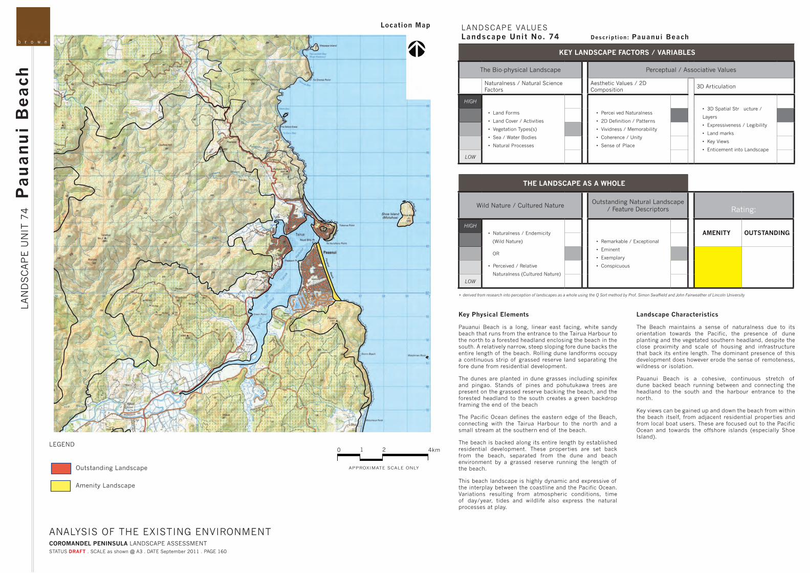
Key Physical Elements
Pauanui Beach is a long, linear east facing, white sandy beach that runs from the entrance to the Tairua Harbour to the north to a forested headland enclosing the beach in the south. A relatively narrow, steep sloping fore dune backs the entire length of the beach. Rolling dune landforms occupy a continuous strip of grassed reserve land separating the fore dune from residential development.
The dunes are planted in dune grasses including spinifex and pingao. Stands of pines and pohutukawa trees are present on the grassed reserve backing the beach, and the forested headland to the south creates a green backdrop framing the end of the beach
The Pacific Ocean defines the eastern edge of the Beach, connecting with the Tairua Harbour to the north and a small stream at the southern end of the beach.
The beach is backed along its entire length by established residential development. These properties are set back from the beach, separated from the dune and beach environment by a grassed reserve running the length of the beach.
This beach landscape is highly dynamic and expressive of the interplay between the coastline and the Pacific Ocean. Variations resulting from atmospheric conditions, time of day/year, tides and wildlife also express the natural processes at play.
Landscape Characteristics
The Beach maintains a sense of naturalness due to its orientation towards the Pacific, the presence of dune planting and the vegetated southern headland, despite the close proximity and scale of housing and infrastructure that back its entire length. The dominant presence of this development does however erode the sense of remoteness, wildness or isolation.
Pauanui Beach is a cohesive, continuous stretch of dune backed beach running between and connecting the headland to the south and the harbour entrance to the north.
Key views can be gained up and down the beach from within the beach itself, from adjacent residential properties and from local boat users. These are focused out to the Pacific Ocean and towards the offshore islands (especially Shoe Island).
• derived from research into perception of landscapes as a whole using the Q Sort method by Prof. Simon Swaffield and John Fairweather of Lincoln University
Location Map

ANALYSIS OF THE EXISTING ENVIRONMENTCOROMANDEL PENINSULA LANDSCAPE ASSESSMENT
STATUS DRAFT . SCALE as shown @ A3 . DATE September 2011 . PAGE 161
LA
ND
SC
AP
E U
NIT
74
Pa
ua
nu
i B
ea
ch
VIEWPOINT 74a. Pauanui Beach fronts the eastern edge of a spit extending north from the mainland, enclosing Tairua Harbour
VIEWPOINT 74b. A steep exposed promontory flanks the southern end of the Beach
VIEWPOINT 74c. A estuarine tributary breaks the dune cover at the southern end of the Beach VIEWPOINT 74d. Spinifex and Pinago grasses hold the fore dune intact

COROMANDEL PENINSULA LANDSCAPE ASSESSMENTSTATUS DRAFT . SCALE as shown @ A3 . DATE September 2011 . PAGE 162
LEGEND
Outstanding Landscape
Amenity Landscape
ANALYSIS OF THE EXISTING ENVIRONMENT
LA
ND
SC
AP
E U
NIT
75
Pa
ua
nu
i H
ea
dla
nd
0
APPROXIMATE SCALE ONLY
4km21
LANDSCAPE VALUESLandscape Unit No. 75 Description: Pauanui Headland
KEY LANDSCAPE FACTORS / VARIABLES
The Bio-physical Landscape Perceptual / Associative Values
Naturalness / Natural Science Factors
Aesthetic Values / 2D Composition
3D Articulation
HIGH
• Land Forms
• Land Cover / Activities
• Vegetation Types(s)
• Sea / Water Bodies
• Natural Processes
• Percei ved Naturalness
• 2D Definition / Patterns
• Vividness / Memorability
• Coherence / Unity
• Sense of Place
• 3D Spatial Structure / Layers
• Expressiveness / Legibility
• Land marks
• Key Views
• Enticement into Landscape
LOW
THE LANDSCAPE AS A WHOLE
Wild Nature / Cultured NatureOutstanding Natural Landscape
/ Feature Descriptors Rating:
HIGH• Naturalness / Endemicity
(Wild Nature)
OR
• Perceived / Relative
Naturalness (Cultured Nature)
• Remarkable / Exceptional
• Eminent
• Exemplary
• Conspicuous
AMENITY OUTSTANDING
LOW
Key Physical Elements
The Pauanui headland rises sharply from the southern end of Pauanui Beach, and stretches south to the north end of Opoutere Beach. The headland dramatically juts out from the mainland, rising steeply from the coast to form a distinctive dome shaped hill that overlooks Pauanui township. A steep exposed escarpment wraps around the coastline, lined with rocky shoals and outcrops along its coastal edge.
Vegetation consists of a mixture of native vegetation and exotic forestry. Exotic forestry is more dominant behind the coastal ridge, with native scrub and coastal forest dominating the coastal slopes, however numerous wilding pines have encroached onto these seaward slopes. Vegetation along the immediate coastal edge includes mature pohutukawa which cling to the lower slopes and rocky outcrops, and has a battered windswept character reflecting its exposed location and interaction with the Pacific Ocean.
This landscape unit is strongly focused and orientated to the east towards the Pacific Ocean and to the north as a backdrop to the Tairua Harbour.
Human activities present within this landscape unit include the presence of exotic forestry.
A combination of features within this landscape are expressive of the natural process at work, including its exposed coastal outlook marked by the rocky coastal edge, the interaction with the Pacific Ocean, heavily forested
slopes, exposed rocky shoals and outcrops dominating the coastal edge and the evidence of erosion marked by pillars of bare rock devoid of vegetation on steeper upper slopes and slips along the coastal edge.
Landscape Characteristics
The jagged rocky coastal edge, scale of the landform and its heavily forested slopes imbue this landscape with a strong sense of naturalness despite the presence of wilding pines and exotic forestry.
The landscape maintains it cohesion through its expressive windswept vegetation, exposure and orientation with its broad coastal slopes and steep gullies dropping down to the ocean from the main north – south orientated ridgeline running down the coast.
This headland is a significant landmark within the Tairua Harbour catchment, forming a strong forested backdrop to Pauanui beach and township when viewed from the north. It also defines the end of Opoutere Beach when viewed from the south.
Due to its elevated scale and prominent location in relation to areas of adjacent development, this landscape is visually exposed to a wide range of public and private viewpoints to the north (concentrated around Pauanui) and south (from Opoutere beach) of the landform, as well as the local boating fraternity who would gain views of the coastal edge.
• derived from research into perception of landscapes as a whole using the Q Sort method by Prof. Simon Swaffield and John Fairweather of Lincoln University
Location Map

ANALYSIS OF THE EXISTING ENVIRONMENTCOROMANDEL PENINSULA LANDSCAPE ASSESSMENT
STATUS DRAFT . SCALE as shown @ A3 . DATE September 2011 . PAGE 163
LA
ND
SC
AP
E U
NIT
75
Pa
ua
nu
i H
ea
dla
nd
VIEWPOINT 75a. The imposing headland dramatically juts out from Pauanui Beach
VIEWPOINT 75b. Coastal forest and exotics cover Pauanui hill as it rises sharply from Tairua Harbour

COROMANDEL PENINSULA LANDSCAPE ASSESSMENTSTATUS DRAFT . SCALE as shown @ A3 . DATE September 2011 . PAGE 164
LEGEND
Outstanding Landscape
Amenity Landscape
ANALYSIS OF THE EXISTING ENVIRONMENT
LA
ND
SC
AP
E U
NIT
76
Ea
st
Co
ast
Isla
nd
s
0
APPROXIMATE SCALE ONLY
4km21
LANDSCAPE VALUESLandscape Unit No. 76 Description: East Coast Islands
KEY LANDSCAPE FACTORS / VARIABLES
The Bio-physical Landscape Perceptual / Associative Values
Naturalness / Natural Science Factors
Aesthetic Values / 2D Composition
3D Articulation
HIGH
• Land Forms
• Land Cover / Activities
• Vegetation Types(s)
• Sea / Water Bodies
• Natural Processes
• Percei ved Naturalness
• 2D Definition / Patterns
• Vividness / Memorability
• Coherence / Unity
• Sense of Place
• 3D Spatial Structure / Layers
• Expressiveness / Legibility
• Land marks
• Key Views
• Enticement into Landscape
LOW
THE LANDSCAPE AS A WHOLE
Wild Nature / Cultured NatureOutstanding Natural Landscape
/ Feature Descriptors Rating:
HIGH• Naturalness / Endemicity
(Wild Nature)
OR
• Perceived / Relative
Naturalness (Cultured Nature)
• Remarkable / Exceptional
• Eminent
• Exemplary
• Conspicuous
AMENITY OUTSTANDING
LOW
Key Physical Elements
The east coast island group consists of approximately six islands numerous rocky outcrops located off the coast between Tapuaetahi Bay in the north and Opoutere Beach in the south. These island and rocky features are characteristically craggy and rocky, varying in size and location, the largest being Slipper Island. Slipper Island contains a number of small golden sandy beaches, located in sheltered positions between rocky outcrops and headlands.
Smaller islands (Waipapa Is, Shoe Is, Watchman Rock, and Penguin and Rabbit Islands) are topped in windswept native vegetation. Slipper Island, by contrast, has vegetated coastal fringes but the rolling landforms dominating the majority of the island are covered in pasture.
The openness and vast scale of the Pacific Ocean provides a dramatic setting for these island landscapes.
No human activities or activities are present the smaller islands, however land use on Slipper Island is dominated by pastoral farming. The Island also contains a boat ramp, a small number if houses and associated roads.
Evidence of erosion is visible on the steeper exposed slopes and rocky cliffs, weathered windswept vegetation, all provide evidence of the natural processes at play on these islands and their interaction with the Pacific Ocean.
Landscape Characteristics
The islands are largely unmodified and have a character that expresses natural processes. Rocky vegetation and weathered vegetation are highly dramatic and expressive of coastal exposure.
The distinct rocky island landforms, presence of indigenous vegetation and consistent weathering and patterning from coastal exposure create a cohesive group of islands off this stretch of coastline.
Each island or rocky outcrop/shoal is a landmark in itself – including (from north to south) Waipapa Island, unnamed island off Otara Bay, Shoe Island (Motuhoa), Watchman Rock, Slipper Island (Whakahau), Penguin Island and Rabbit Island.
The islands are visible from a number of public and private viewpoints down this eastern stretch of coastline as far south as ¬¬Opoutere. The Islands are particularly exposed to larger settlements along this coastline including Tairua and Pauanui.
• derived from research into perception of landscapes as a whole using the Q Sort method by Prof. Simon Swaffield and John Fairweather of Lincoln University
Location Map

ANALYSIS OF THE EXISTING ENVIRONMENTCOROMANDEL PENINSULA LANDSCAPE ASSESSMENT
STATUS DRAFT . SCALE as shown @ A3 . DATE September 2011 . PAGE 165
LA
ND
SC
AP
E U
NIT
76
Ea
st
Co
ast
Isla
nd
s
VIEWPOINT 76a. Panoramic view of the exposed pastoral form of Slipper Island as seen from Paku with contrasting vegetated Penguin and Rabbit Island to the right
VIEWPOINT 76b. Windswept coastal forest covers dome shaped form of Penguin Island
VIEWPOINT 76c. View of Shoe Island form Paku VIEWPOINT 76d. A shag colony occupy an unnamed Island just offshore from Otara Bay