Embed Size (px)
Citation preview
Geoarcheology Research Associates 1 Investigations Site (36SQ17) Great Bend
Table of Contents
List of Figures and Plates . . . . . . . . . . . . . . . . . . . . . . . . . . . . . . . . . . . . . . . . . . . . . . . . .
List of Tables . . . . . . . . . . . . . . . . . . . . . . . . . . . . . . . . . . . . . . . . . . . . . . . . . . . . . . . . . . .
1.0
2.0
3.0
4.0
5.0
6.0
7.0
8.0
9.0
Introduction . . . . . . . . . . . . . . . . . . . . . . . . . . . . . . . . . . . . . . . . . . . . . . . . . . . . . . .
Regional Physiography, Bedrock Geology, and Quaternary Stratigraphy . . . . . . .
History of Geomorphological Investigations . . . . . . . . . . . . . . . . . . . . . . . . . . . . .
Initial Testing of the Great Bend site (36SQ17) . . . . . . . . . . . . . . . . . . . . . . . . . . .
Great Bend Site Master Stratigraphy . . . . . . . . . . . . . . . . . . . . . . . . . . . . . . . . . . . .
Sedimentological and Geochemical Characteristics of the Composite
Profile . . . . . . . . . . . . . . . . . . . . . . . . . . . . . . . . . . . . . . . . . . . . . . . . . . . . . . . . . . . .
The Composite Sequence at Site 36SQ17 . . . . . . . . . . . . . . . . . . . . . . . . . . . . . . . .
Comparisons with Stratified Site 36SQ111 . . . . . . . . . . . . . . . . . . . . . . . . . . . . . . .
Conclusions . . . . . . . . . . . . . . . . . . . . . . . . . . . . . . . . . . . . . . . . . . . . . . . . . . . . . . . .
2
2
4
7
9
12
20
29
32
35
40
43References . . . . . . . . . . . . . . . . . . . . . . . . . . . . . . . . . . . . . . . . . . . . . . . . . . . . . . . . . . . . . .
Geoarcheology Research Associates 2 Investigations Site (36SQ17) Great Bend
List of Figures and Plates
List of Tables
Figure 1.
Figure 2.
Figure 3.
Figure 4.
Figure 5.
Figure 6.
Figure 7.
Figure 8.
Plate 1.
Plate 2.
Plate 3.
Plate 4.
Plate 5.
Site Location on Great Bend 7.5’ USGS Quadrangle Map . . . . . . . . . . . . . . .
Hallstead-Great Bend Bridge Replacement, NE Quadrant,
Trench 99-2, Profile looking West . . . . . . . . . . . . . . . . . . . . . . . . . . . . . . . . . .
Hallstead-Great Bend Bridge Replacement, NE Quadrant,
Trench 99-3, Profile looking East . . . . . . . . . . . . . . . . . . . . . . . . . . . . . . . . . .
Hallstead-Great Bend Bridge Replacement, NE Quadrant,
Trench 99-1, Profile looking East . . . . . . . . . . . . . . . . . . . . . . . . . . . . . . . . . .
Allostratigraphic Framework for the 36SQ17 APE Excavation
Block . . . . . . . . . . . . . . . . . . . . . . . . . . . . . . . . . . . . . . . . . . . . . . . . . . . . . . . . .
Composite Stratigraphy of the Great Bend Site (36SQ17) . . . . . . . . . . . . . . .
Landform and Subsurface Relations of the Great Bend
Site (36SQ17) . . . . . . . . . . . . . . . . . . . . . . . . . . . . . . . . . . . . . . . . . . . . . . . . . . .
Landforms, Stratigraphy, and Archeology Between Sites
36SQ17 and 36SQ111 . . . . . . . . . . . . . . . . . . . . . . . . . . . . . . . . . . . . . . . . . . . .
Trench 99-2, view across west wall toward the APE perimeter fence . . . . . .
View of backhoe excavating Trench 99-1 and the existing Susquehanna
River bridge . . . . . . . . . . . . . . . . . . . . . . . . . . . . . . . . . . . . . . . . . . . . . . . . . . . .
View of the initial 5 m x 5 m excavation block looking southeast . . . . . . . .
View of the 9 m x 5 m shored excavation block . . . . . . . . . . . . . . . . . . . . . . .
4Btx horizon showing moderate medium prismatic ped structure and
continuous clay films . . . . . . . . . . . . .. . . . . . . . . . . . . . . . . . . . . . . . . . . . . . . .
Great Bend Site (36SQ17) Master Soil Stratigraphy . . . . . . . . . . . . . . . . . . . .
Great Bend Site (36SQ17) Sediment and Granulometry Analysis . . . . . . . . .
Landforms, Stratigraphy and Archeology in the vicintiy of Site
36SQ111 . . . . . . . . . . . . . . . . . . . . . . . . . . . . . . . . . . . . . . . . . . . . . . . . . . . . . . .
Table 1.
Table 2.
Table 3.
3
13
15
17
19
31
33
38
14
16
20
22
23
25
29
39

Geoarcheology Research Associates 3 Investigations Site (36SQ17) Great Bend
Figure 1. Project location from USGS 7.5’ Great Bend Quadrangle. Map shows location of
Site 36SQ17 and a neighboring site (36SQ111).

Geoarcheology Research Associates 4 Investigations Site (36SQ17) Great Bend
Introduction
The Great Bend site (36SQ17) is a deeply buried, multi-component archeological site along the
Upper Susquehanna River near the town of Great Bend, Susquehanna County, Pennsylvania (Figure
1). Initial (Phase I) archeological and geomorphological investigations (Pan Cultural Associates 1998)
for the Hallstead/Great Bend Bridge replacement suggested that the T-0 landform flanking the bridge
on the northeast had potential for preserving buried archeological deposits at depths 2-2.5 meters
beneath the surface. The T-0 was defined at an elevation of ca. 261-262 masl. The McDonald’s
Restaurant, the key landmark for the site, was considered to be a built up extension of the T-1 surface
(elevation ca. 269 asl) and subsurface disturbance rendered it insensitive for preservation of prehistoric
cultural resources.
In 1999, Geoarcheology Research Associates (GRA) was contracted by CHRS to undertake
subsurface testing attendant to the Phase I recommendations. Field relations and initial trenching
verified the presence of an intermediate terrace between the T-0 and the formerly designated T-1. This
extensive landform was reclassified T-1 at an elevation of 265 masl. The former T-1 landform (supporting
McDonald’s) was reclassified T-2.
Over the course of subsurface testing, it was discovered that the T-1 capped a sequence of four
discrete stratigraphic units. These units are unconformably stratified and are traceable, with lateral
variability, across the T-1 landform in the site vicinity. Unit designations were developed on the basis
of an allostratigraphic sequence, one which considers the individual unit to be “a mappable stratiform
body of sedimentary rock that is defined and identified on the basis of its bounding discontinuity”
(NASCN 1983: 865). The advantage of this type of sequence for archeology is that it recognizes the
contemporeneity of different types of stratigraphic components—artifacts, soils, sediments—as the
ordering principle for vertical succession. Thus, for example, a set of potsherds of clear Middle
Woodland association preserved in a sandy flood deposit can be assigned to the same allostratigraphic
unit as a buried soil that has been radiocarbon dated to the same period but contains no artifacts
whatsoever.
At 36SQ17 the four (4) allostratigraphic units are briefly summarized below:
• ASU IV; historic fill (0-1.0 m);

Geoarcheology Research Associates 5 Investigations Site (36SQ17) Great Bend
• ASU III; prehistoric deposits overlying/interdigited with early historic fill; cultural
sediments articulate with renewed high energy accretion deposits (0.6-1.0 m);
• ASU II; overbank alluvium and well developed soil horizon of Middle Holocene age
(2.0-2.4 m);
• ASU I; laterally accreted Early-Middle alluvium with thin to thick soils and a
preserved prehistoric component of (probable) Middle Archaic age (2.4->3.2 m).
The lowermost prehistoric component did not contain diagnostic artifacts but yielded dates in the
range of 8500-7000 B.P. The uppermost archeological deposits are of Late Woodland (Owasco culture)
affinity. The reclassified T-1 landform which houses the prehistoric components is of Holocene age
and occurs intermittently throughout the Susquehanna River valley (Schuldenrein 2002; Thieme and
Schuldenrein 1998; Vento et al. 1999). An unconformable contact with upper Pleistocene outwash
occurs at the base of the terrace, approximately 4.5 m below the land surface. Radiocarbon dates for
the basal Holocene sediments range from 8320±50 B.P. to 11,160±40 B.P., with the younger dates
representing charred material directly associated with an assemblage of early Middle Archaic lithic
artifacts.
The excavations described in the present report were within the area of potential effect (APE) of
construction activities for replacement of the S.R. 11 bridge over the Susquehanna River (see Figure
1). The report begins with the regional geology and what is known about the Quaternary geologic
history of this part of the Susquehanna River valley. The history of geomorphological investigations
in this part of Pennsylvania and adjacent New York State is then briefly summarized.
The master stratigraphy of site 36SQ17 was developed on the strength of identifications of 30
soil horizons or discrete fill deposits, which were traced by careful hand excavation. The excavation
block within the APE had final dimensions of 9 m x 5 m at the top. As noted, there are four basic
packages of sediment, or allostratigraphic units (Autin 1992; NACSN 1983) in the terrace, of which
only two contained in situ prehistoric archeological contexts within the excavation block. Following a
description of the master profile from top to bottom of the site, sedimentological and geochemical
characteristics are discussed in detail based on laboratory results for a total of 36 soil sediment samples.
Because this is such a deep and well-characterized stratigraphic profile, these details should prove
Geoarcheology Research Associates 6 Investigations Site (36SQ17) Great Bend
relevant to archeological reconnaissance and predictive modeling in alluvial settings throughout eastern
and central Pennsylvania and adjacent south central New York.
It is noted that the uppermost package (Allostratigraphic Unit IV) at site 36SQ17 consists of a
series of late-19th through 20th century fill deposits. The sedimentology of these deposits is discussed
in some detail in a final section, and they are compared with the deposits which housed the prehistoric
contexts. Once again, these data should prove useful for interpretation of sites where similar stratigraphy
occurs but the analytical budget is less robust.
The final sections of this report explores some possible correlations between the stratigraphic
framework developed for site 36SQ17 and other alluvial landscapes in the immediate vicinity. In
particular, a recently developed geoarcheological sequence at site 36SQ111 is examined for landform
succession and subsurface stratigraphy. The latter site underscores the difficulties in unraveling complex
alluvial chronologies where landform morphologies have been variously altered by land development
and upper stratigraphies have been destroyed by large scale stripping and filling.

Geoarcheology Research Associates 7 Investigations Site (36SQ17) Great Bend
Regional Physiography, Bedrock Geology, and Quaternary Stratigraphy
Susquehanna County is in the glaciated portion of the Appalachian Plateaus physiographic province
(Berg et al. 1989; Briggs 1999). Relief of approximately 300 meters occurs between the local elevation
of ca. 261(?) m MSL at river grade and ridge summits visible to the south and north. The bedrock is
slightly folded siltstone and fine-grained sandstone of Upper Devonian age. Formerly this was known
as the Chemung formation (Stevenson 1891; White 1881; Willard 1934; Willard et al. 1939), and the
term Chemung is still used by some geologists working in New York State for a tidally-influenced
facies with abundant silt and clay (Isachsen et al. 2000: 122-126; Woodrow 1963). The term Lockhaven
is currently favored in Pennsylvania (Berg et al. 1980) for the nearly flat-lying beds of gray or greenish
gray rock, which are extracted for flagstone at many nearby quarries.
The prevalence of sedimentary lithologies throughout the Susquehanna River valley makes many
glacial deposits immediately identifiable based on the occurrence of erratic clasts from metamorphic
and igneous lithologies. Great Bend is approximately 120 km north of the terminal moraine for the
late Wisconsinan glacial advance, which is just upstream of Berwick in the North Branch of the
Susquehanna River valley (Braun 1988, 1994; Crowl and Sevon 1980, 1999). The Wisconsinan terminal
moraine is estimated to be approximately 18,000 years old by Cotter et al. (1986) while a slightly older
age may be indicated by 29 radiocarbon dates greater than 20 ka obtained from outwash deposits at
Port Washington on Long Island by Sirkin (Sirkin 1986; Sirkin and Stuckenrath 1980).
The rate of retreat of the Laurentide ice sheet from its terminal moraine is not well constrained
since glacial deposits contain few organic materials dateable using radiocarbon techniques. Pennsylvania
was definitely free of glacial ice by 14,000 years ago, the age assigned to the “Valley Heads” margin at
the southern tip of the Finger Lakes in New York State (Braun 1994, Muller and Calkin 1993). Meltwater
floods lasted until at least this late in the Chemung and Chenango River valleys north and west of
Binghamton, where the valley train has a “bright” appearance due to common clasts of limestone
scoured from the Finger Lakes glacial troughs (Denny 1956; Denny and Lyford 1963; MacClintock and
Apfel 1944).
Upstream of Binghamton at least as far as Great Bend, a proglacial lake filled the Susquehanna
River valley and extended south up Salt Lick Creek valley (Braun 1999; Braun et al. 1999). The spillpoint
for glacial lake Great Bend was the divide between Salt Lick Creek and a south-flowing tributary of
Tunkhannock Creek. Gravel terraces in the Tunkhannock Creek valley are in part the result of
Geoarcheology Research Associates 8 Investigations Site (36SQ17) Great Bend
catastrophic discharges across the divide. Stratigraphic evidence of glacial lake Great Bend in the
immediate vicinity of site 36SQ17 includes well-sorted sand sheets in the lower reaches of Salt Lick
Creek and ice-contact deltas on the valley walls. Once the outlet to the west was unblocked, multiple
channels were incised into the proglacial lake sediments. Most of these appear to have been considerably
to the north of the present river channel at Great Bend. Streams north of Penny Hill such as Trowbridge
Creek may have carried much larger flows and transported more sediment at this point, and at least one
relict channel can be discerned running approximately parallel to S.R. 171 east of interstate highway I-
81.
Gravelly to coarse sandy textures in the upper Pleistocene deposits, contrasting with fine sandy to
silty textures in the Holocene alluvium, make it possible to map much of the Quaternary geomorphology
of northeastern Pennsylvania on the basis of the U.S.D.A. county soil surveys. Within the Susquehanna
River valley, the Chenango and Wyoming series typically occur on outwash terraces (T-2 and higher)
while the Barbour and Basher series occur on the T-1 terrace or in the active floodplain (Reber 1973).
The T-2 at Hallstead, on the left bank of the river within the S.R. 11 bridge replacement area, is thus
identifiable as a glacial landform based on the occurrence of the gravelly Chenango series. The T-1
which housed the Great Bend archeological site (36SQ17) is mapped with the Barber series. The
floodplain (T-0) surface less than a meter above river grade cannot be distinguished using the mapped
soils, however, and urban disturbance makes many of the geomorphic relationships unclear without
subsurface investigations.
Geoarcheology Research Associates 9 Investigations Site (36SQ17) Great Bend
History of Geomorphological Investigations
Great Bend, Pennsylvania is closer to Binghamton, New York than it is to any of the cities in
Pennsylvania. This fact has affected what little previous research has been conducted on these reaches
of the Susquehanna River valley. An early reconnaissance was conducted by H. L. Fairchild (1925),
financed by the New York State Science and Museum Service. In order to account for the ice-contact
deltas and outwash plains he observed, Fairchild proposed an immense glacial lake extending all the
way from Towanda, Pennsylvania upstream past Binghamton to Great Bend, a distance of over 120
km. The recent glacial lake Great Bend reconstruction (Braun 1999; Braun et al. 1999) is considerably
more modest and more or less independent of the ice-recessional history in the valleys now occupied
by the Chenango and the Chemung Rivers.
MacClintock and Apfel (1944) described Pleistocene glacial drift in the Salamanca Reentrant and
extended the units observed throughout south central New York. They proposed a still-stand or
discrete recessional position in the Binghamton area, but this has been disputed by subsequent
stratigraphers working with the Binghamton deposits (Coates 1963; Denny and Lyford 1963; Moss
and Ritter 1962). Randall (1972) compiled boring logs throughout the Susquehanna River valley between
Oneonta and Binghamton. While up to 120 m of gravelly outwash occur in some locations, less than
30 m were found to occur at Great Bend.
The concavo-convex form of hill-slopes immediately north of Great Bend was described by
Coates (1974: 225-226) as a feature inherited from the recession of the ice sheet. Solufluction was
caused by the heavy load of till on slopes inadequately stabilized by vegetation. Coates further linked
the downslope convexity to concave depressions on adjacent uplands. Water moves between these
features by through-flow, increasing the pore water pressure of sediments on the lower hill-slope
segments. The resulting upper Pleistocene through Holocene colluvium was shown to extend downslope
into the channels of the southwest trending Trowbridge Creek drainage.
A pioneering investigation of Holocene alluvial stratigraphy was conducted in the upper
Susquehanna River Basin by Scully and Arnold (1979, 1981) with the objective of evaluating the
relationship between soil properties and terrace age. One of the study sites was along the Susquehanna
River downstream of its confluence with the Unadilla River while the other site was along the Unadilla
upstream of the confluence. The T-1 was recognized as a Holocene alluvial terrace distinct from the
active floodplain (T-0), and individual packages of alluvium were identified on the basis of the soils
Geoarcheology Research Associates 10 Investigations Site (36SQ17) Great Bend
which formed at their upper bounding surface. Unfortunately, the study site is over 50 km upstream of
Great Bend and the T-1 exposures have yet to be examined for most of the intervening reaches.
Maps of surficial geology for the entire state of New York at a scale of 1:250,000 were published
beginning in 1986, and the Susquehanna River originates on the Hudson-Mohawk sheet (Cadwell and
Dineen 1987) and continues across the Finger Lakes sheet (Cadwell and Dineen 1987). Holocene
alluvium (al) is distinguished from glacial outwash sand and gravel (og) on both sheets but greater
detail on the youngest deposits can often be obtained from the county soil surveys.
A particularly fruitful collaboration between Quaternary geologists and archeologists was initiated
by Robert Funk during the 1970’s in his investigations in the Upper Susquehanna Valley (Funk 1993,
1997; Funk and Rippeteau 1977). Funk’s project studied archaeological sites along the Susquehanna
River upstream of its juncture with the Unadilla River. Kirkland and Funk (1979) linked postglacial
alluvial change with prehistoric settlement patterns, noting a low terrace formed by lateral migration
ca. 4200-4500 B.P. coinciding with the Lamoka and Vestal phases of prehistoric culture. Subsequently,
Dineen (1993) identified at least three Holocene terraces in the vicinity of several of the archeological
sites. Less than a meter of relief marks most of the terraces mapped by Dineen, however, and they
have yet to be traced beyond the reaches of the initial study.
Geomorphological studies in conjunction with archeological fieldwork in the Hallstead-Great
Bend area began in the early 1990’s when the SUNY-Binghamton Public Archeology Facility identified
and tested the sites which were impacted by the Pennsylvania American Water Company pipeline
(Versaggi et al. 1993; Wurst and Lain 1996). Vento undertook most of the deep testing efforts for
these projects and proposed a total of five (5) terraces for these valley reaches. Interpretations were
modeled after the description by Peltier (1949) and projected between three and five terraces in the
reaches between Athens, Pennsylvania and the terminal moraine.
Kame or ice-contact delta deposits occur over 30 m above river grade, and Vento followed the
stratigraphic terminology proposed by Crowl and Sevon (1980) in referring to such active ice deposition
as “Olean” as opposed to “Binghamton.” Peltier, on the other hand, used the term Binghamton
extensively and identified what he considered to be a recessional moraine for the Binghamton ice in
the vicinity of Milan, Pennsylvania (Peltier 1949: 89-91). A higher percentage of far-traveled clasts
derived from igneous and metamorphic lithologies of the Mohawk Valley and the Adirondack Mountains
Geoarcheology Research Associates 11 Investigations Site (36SQ17) Great Bend
is commonly considered to be characteristic of the Binghamton deposits (Coates 1976: 65; Peltier
1949: 18).
At Great Bend, Vento proposed an Olean outwash terrace (T-4) at 18 m above river grade and a
Binghamton terrace (T-3) at 14 m above river grade, which seems inconsistent since the study location
is upvalley of both proposed moraines. The proposed Valley Heads terrace (T-2) at 7.6 m and Port
Huron terrace (T-1) at 3.5-6 m above river grade are characterized as having a “veneer” of Holocene
alluvium, and have generally been found in previous studies to be more veneer than gravel. The actual
discharges from heads of outwash north of the Valley Heads recessional moraine are as yet poorly
understood and were probably greatest in the Chemung and Chenango River valleys.
A simpler approach has been taken in the present report, grouping all of the outwash surfaces
into a single T-2 from 8-14 m above river grade and proposing a Holocene T-1 surface from 3-5 m
above river grade which correlates upriver with surfaces previously mapped by Scully and Arnold
(1979, 1981) and Dineen (1993). Upper Pleistocene deposits found at elevations above that proposed
for T-2 show evidence of deposition in very close proximity to active ice rather than from meltwater
floods.
Frank Vento also reported on an initial phase of investigations for replacement of the S.R. 11
bridge (Pan Cultural Associates 1998). In that study, the T-1 landform housing site 36SQ17 was referred
to as a T0 terrace, while the floodplain in the southeast quadrant upstream of the mouth of Salt Lick
Creek was referred to as T00. The present studies in the southwest and southeast quadrants of the S.R.
11 bridge replacement have been reported previously under separate cover (Thieme et al. 1999a, 1999b).
Vento’s general model of the project area was confirmed in that there was little or no potential for
preservation of prehistoric archeological contexts in the active floodplain (T-0) at elevations less than
three meters above river grade. Significantly, the limited field investigations conducted at the Hallstead
Park Site (36SQ31) (Wurst and Lain 1996) provided a more complete stratigraphic and geomorphic
context for this multi-component prehistoric site on the T-2 surface.
Geoarcheology Research Associates 12 Investigations Site (36SQ17) Great Bend
Initial Testing of the Great Bend site (36SQ17)
The present investigations of the Great Bend site (36SQ17) began with a series of three backhoe
trenches, two of which were excavated as close as possible to locations previously tested by Pan Cultural
Associates (1998). All of these trench locations were outside the APE which was eventually defined by
project engineers, but the exposures were used to preview the stratigraphy subsequently encountered
in the larger block excavation. The fieldwork was conducted in very cold weather early in 1999, and
frozen ground limited profile exposures, detailed mapping, and interpretation of the deposits. There
were also some problems relocating the original trenches in spite of a site visit by personnel from Pan
Cultural Associates.
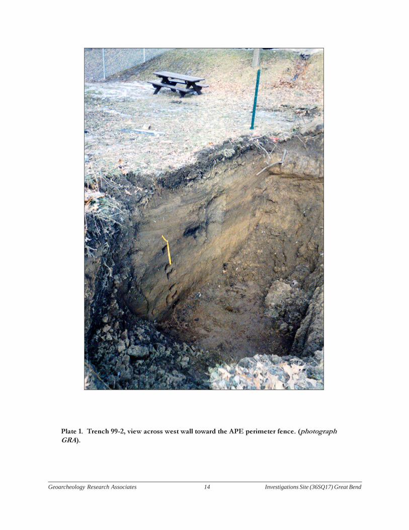
Trench 99-2 reopened Pan Cultural’s Trench 2 (Figure 2). A prehistoric charcoal concentration,
probably a hearth, was encountered in the west wall profile (Plate 1) at a depth of approximately a
meter below surface (264 m MSL). The profile was described and a hand auger was used to core in the
floor of the trench. As shown in Figure 2, a hearth was exposed in section at the interface of ASU III
and ASU IV. While the cultural affiliation of the hearth feature is unknown, it occurs at the base of a
2Ab horizon which appears to correlate stratigraphically with deposits dated to 4780±40 B.P. (Beta-
128115) within the excavation block. A sample of bulk sediment from the 4Ab soil horizon (ASU-I)
approximately two meters below surface (263 m MSL) was subsequently radiocarbon dated to 7360±80
B.P. (Beta-128117). Unfortunately, there were no archeological contexts associated with this stratigraphic
package in the APE excavation block. Significantly, however, the proejcted feature date and the dated
bulk sediments are in stratigraphic order and their respective dates are consistent with the absolute
chronology of other portions of the site.
Geoarcheology Research Associates 13 Investigations Site (36SQ17) Great Bend
Figure 2
Geoarcheology Research Associates 14 Investigations Site (36SQ17) Great Bend
Plate 1. Trench 99-2, view across west wall toward the APE perimeter fence. (photograph
GRA).
Geoarcheology Research Associates 15 Investigations Site (36SQ17) Great Bend
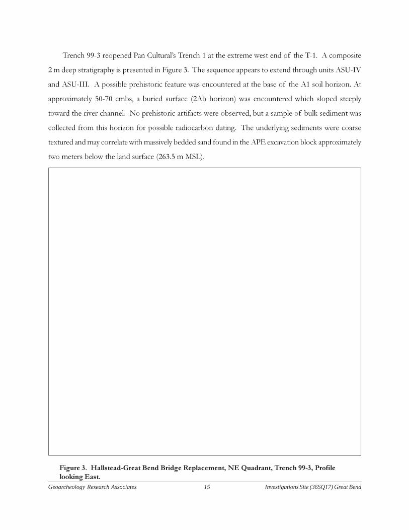
Figure 3. Hallstead-Great Bend Bridge Replacement, NE Quadrant, Trench 99-3, Profile
looking East.
Trench 99-3 reopened Pan Cultural’s Trench 1 at the extreme west end of the T-1. A composite
2 m deep stratigraphy is presented in Figure 3. The sequence appears to extend through units ASU-IV
and ASU-III. A possible prehistoric feature was encountered at the base of the A1 soil horizon. At
approximately 50-70 cmbs, a buried surface (2Ab horizon) was encountered which sloped steeply
toward the river channel. No prehistoric artifacts were observed, but a sample of bulk sediment was
collected from this horizon for possible radiocarbon dating. The underlying sediments were coarse
textured and may correlate with massively bedded sand found in the APE excavation block approximately
two meters below the land surface (263.5 m MSL).
Geoarcheology Research Associates 16 Investigations Site (36SQ17) Great Bend
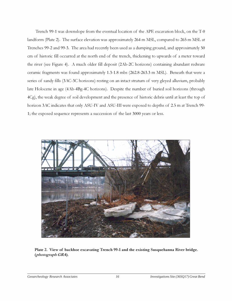
Plate 2. View of backhoe excavating Trench 99-1 and the existing Susquehanna River bridge.
(photograph GRA).
Trench 99-1 was downslope from the eventual location of the APE excavation block, on the T-0
landform (Plate 2). The surface elevation was approximately 264 m MSL, compared to 265 m MSL at
Trenches 99-2 and 99-3. The area had recently been used as a dumping ground, and approximately 50
cm of historic fill occurred at the north end of the trench, thickening to upwards of a meter toward
the river (see Figure 4). A much older fill deposit (2Ab-2C horizons) containing abundant redware
ceramic fragments was found approximately 1.3-1.8 mbs (262.8-263.3 m MSL). Beneath that were a
series of sandy fills (3AC-3C horizons) resting on an intact stratum of very gleyed alluvium, probably
late Holocene in age (4Ab-4Bg-4C horizons). Despite the number of buried soil horizons (through
4Cg), the weak degree of soil development and the presence of historic debris until at least the top of
horizon 3AC indicates that only ASU-IV and ASU-III were exposed to depths of 2.5 m at Trench 99-
1; the exposed sequence represents a succession of the last 3000 years or less.

Geoarcheology Research Associates 17 Investigations Site (36SQ17) Great Bend
Figure 4
Geoarcheology Research Associates 18 Investigations Site (36SQ17) Great Bend
Of the three trenches excavated, Trenches 99-1 and 99-2 were the closest to the APE defined by
the project engineers. The Trench 99-1 profile represents a portion of the river floodplain (T-0) that
had been artificially built up to within a meter of the T-1 surface which houses the prehistoric
archeological contexts. Trench 99-2 was on an intact portion of the original T-1 and therefore served
as a better model to use in planning the block excavation within the APE. Four allostratigraphic units
were numbered sequentially beginning at the basal deposits described from a core in the floor of the
trench (see Figure 5). These same units were also identified in Core 99-11, taken within the APE
excavation block at grid coordinates N58/E52.
Trenches 99-2 and 99-3 illustrated the variable depth and complexity of historic occupation (ASU-
IV) as well as the waning phases of dominant overbanking near the end of the prehistoric (Late
Archaic and Woodland) period (ASU-III).
When Core 99-11 was taken, excavation had begun within an initial 5 m x 5 m block. The upper
levels were difficult to interpret because of thick accumulations of historic fill, which typically included
much organic-rich sediment from the underlying A horizon. Prehistoric artifacts from various periods
were found in these upper deposits, many of which probably washed downslope from the portion of
the site which has been paved over by the McDonald’s parking lot. The allostratigraphic framework
correlating Core 99-11 with Trench 99-2 suggested the depth at which intact, archeologically sensitive
deposits would be found.
Two radiocarbon dates were obtained on samples from Core 99-11 in March, 1999. A date of
4780±40 B.P. (Beta-128115) was obtained for a sample from the 2Ab horizon at 263.85 m MSL, and a
date of 7630±100 B.P. (Beta-128116) was obtained for a sample from the 4Ab horizon at 263.15 m
MSL. As discussed in the following sections on the stratigraphy of the excavation block, these dates
agree quite well with all of the other available age estimates from the site.

Geoarcheology Research Associates 19 Investigations Site (36SQ17) Great Bend
Figure 5

Geoarcheology Research Associates 20 Investigations Site (36SQ17) Great Bend
Great Bend Site Master Stratigraphy
There are a total of 30 soil horizons or discrete fill deposits in the master stratigraphy of site
36SQ17 (Table 1). Because most of the T-1 alluvium consists of relatively flat-lying, conformable
beds, it was possible to trace all four of the allostratigraphic units through the excavation block (Plate
3). ASU-I was found to be considerably thicker and more archeologically sensitive than was suspected
based on the channel and point bar sands sampled in the core at the base of Trench 99-2. It was
extremely difficult to devise an appropriate “window” for investigation of the deepest ASU-1 deposits
due to safety considerations. Only the upper portion of ASU-1, designated ASU-1c on Plate 3, was
exposed within the maximum depth of three meters attained by stepping of the initial 5 x 5 m excavation
block.
Plate 3. View of the initial 5 m x 5 m excavation block looking southeast. (photograph GRA).
Geoarcheology Research Associates 21 Investigations Site (36SQ17) Great Bend
The majority of the sediment excavated from the block belonged to ASU-IV, which was not
initially expected to be significant from an archaeological standpoint. However, several large Woodland
(Owasco culture) pit features were found at the top of the C1 horizon, from 50 to 90 cm below the
original land surface. The 5 m x 5 m block was stepped in to 3 m x 3 m approximately 30 cm above the
2Ab horizon at the top of ASU-III (Figure 5). The 2Ab horizon was initially expected to contain
relatively dense concentrations of Late Archaic midden or pit features. No features were found and
the artifact density appeared to have declined. While the stratigraphy correlated quite closely with
Trench 99-2, it was difficult to use it to predict the relatively small and discrete cultural activity areas on
site 36SQ17.
The final step in the initial excavation block occurred at the top of the 3Bw horizon, a very
compact subsoil discolored by oxidized iron. The 3Bw represents an entire sediment package, ASU-II,
on both sedimentological and pedological grounds. It was truncated by a scour episode and
unconformably overlain by the much coarser flood sands of the 2C horizon. Its firm consistence
made it a convenient place at which to step the excavation down to a 1 m x 1 m unit. Radiocarbon ages
of 7,630±100 B.P. (Beta-128116) for the 4Ab horizon at the top of ASU-Ic and 4,780±40 B.P. for the
2Ab horizon (or 2C) at the top of ASU-III indicate a mid-Holocene age for this strongly oxidized Bw
horizon scoured by a relatively high energy flood event.
A column of sixteen soil sediment samples, Column 1, was collected from the east wall profiles of
each step in the initial block excavation (Table 2). Soil monoliths were collected across horizon
boundaries in ASU-I and ASU-II for soil micromorphology (Courty et al. 1989). Specifically, a block
was collected from the 2C/3Bw contact, the 3Bw/4AB contact, and the 4AB/4Bt contact.
Micromorphological study is in progress, both to corroborate the general stratigraphic framework and
to compare the degree of soil development with samples from soils of similar age.

Geoarcheology Research Associates 22 Investigations Site (36SQ17) Great Bend
No prehistoric cultural material was recovered from ASU-I in this initial excavation, but a core
taken in the floor of the 1 m x 1 m unit indicated that at least another meter of sandy sediment was
present above the upper Pleistocene outwash gravel. The entire excavation block was consequently
expanded at this point into a 9 m x 5 m block, within which it was possible to attain a total depth of
slightly over four meters. Wooden shoring was used to make the excavation safe (Plate 4).
Plate 4. View of the 9 m x 5 m shored excavation block. (photograph GRA).
The basic framework of four allostratigraphic units was also valid for the much larger block,
although many of the beds were less flat-lying and there had been considerably more disturbance of
this area during the late-19th through 20th centuries. The undisturbed C horizon which contained the
Late Woodland contexts could not be traced more than a meter or two west of the E46 line. ASU-IV
extended as deep as 160 cm below surface (263.5 m MSL) in the southwest corner of the block (N54/
E43). Interstratified muddy fills (Fills Ia, Ib, II, III, IV, and V) and coarser sandy fills (Sands I and II)
represent a combination of dumping episodes and natural colluviation. A deep trench had been
excavated running north-south, and organic refuse pushed into this depression gave the appearance of
an intact buried soil on the alluvial terrace.
Geoarcheology Research Associates 23 Investigations Site (36SQ17) Great Bend
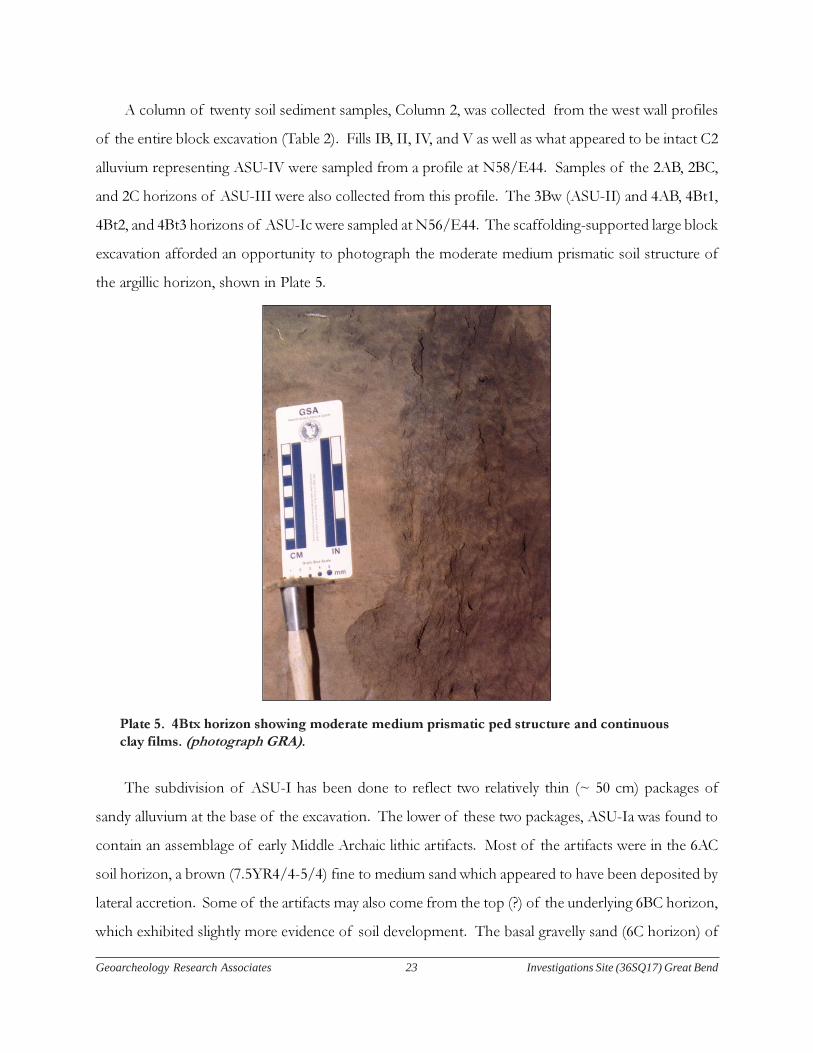
A column of twenty soil sediment samples, Column 2, was collected from the west wall profiles
of the entire block excavation (Table 2). Fills IB, II, IV, and V as well as what appeared to be intact C2
alluvium representing ASU-IV were sampled from a profile at N58/E44. Samples of the 2AB, 2BC,
and 2C horizons of ASU-III were also collected from this profile. The 3Bw (ASU-II) and 4AB, 4Bt1,
4Bt2, and 4Bt3 horizons of ASU-Ic were sampled at N56/E44. The scaffolding-supported large block
excavation afforded an opportunity to photograph the moderate medium prismatic soil structure of
the argillic horizon, shown in Plate 5.
Plate 5. 4Btx horizon showing moderate medium prismatic ped structure and continuous
clay films. (photograph GRA).
The subdivision of ASU-I has been done to reflect two relatively thin (~ 50 cm) packages of
sandy alluvium at the base of the excavation. The lower of these two packages, ASU-Ia was found to
contain an assemblage of early Middle Archaic lithic artifacts. Most of the artifacts were in the 6AC
soil horizon, a brown (7.5YR4/4-5/4) fine to medium sand which appeared to have been deposited by
lateral accretion. Some of the artifacts may also come from the top (?) of the underlying 6BC horizon,
which exhibited slightly more evidence of soil development. The basal gravelly sand (6C horizon) of
Geoarcheology Research Associates 24 Investigations Site (36SQ17) Great Bend
ASU-Ia is probably upper Pleistocene outwash and consistent with the radiocarbon date of 11,180±40
B.P. (Beta-133919). Unfortunately, however, that date was obtained on a sample out of stratigraphic
sequence, from the 5AC horizon in ASU-Ib.
The basal 6C gravels at 259.5 m MSL are typically below river grade. Fortunately, limited stratigraphic
inspections were undertaken in the drier summer and fall months when the excavation was completed.
Samples representing ASU-Ia and ASU-Ib were collected in cramped conditions from the west wall
profile at approximately N54.5/E44. The 6AC, 6BC, and 6C samples in Column 2 represent ASU-Ia
while the 5AC and 5C samples represent ASU-Ib. Two more samples from ASU-Ic, from the 4C2a and
4C2b horizons, were also collected from this profile.
The field nomenclature for soil horizons in the above master stratigraphy has been corroborated
with laboratory analyses of particle size and soil chemistry. The test of the allostratigraphic framework
in many ways was the fact that contacts occurred at predictable depths within the excavation block.
Some modifications were made during the course of the excavation. It should also be noted that
secure dating of the cultural horizons is also impeded by the lack of diagnostic archeological material.

Geoarcheology Research Associates 25 Investigations Site (36SQ17) Great Bend
Table 1. Great Bend Site (36SQ17) Master Soil Stratigraphy

Geoarcheology Research Associates 26 Investigations Site (36SQ17) Great Bend

Geoarcheology Research Associates 27 Investigations Site (36SQ17) Great Bend

Geoarcheology Research Associates 28 Investigations Site (36SQ17) Great Bend
Table 2

Geoarcheology Research Associates 29 Investigations Site (36SQ17) Great Bend
Sedimentological and Geochemical Characteristics of the Composite Profile
The two columns of soil sediment collected from the site 36SQ17 APE excavation block overlap
from ASU-Ic up-section to the top of ASU-III. A composite stratigraphic column of 23 samples was
assembled from the two columns, running from the base of the excavation at 259.80 m MSL (6C
horizon) up to the A/C horizon at 264.40 m MSL. The nine samples at the base of the composite
profile were collected from the west wall profiles (N56/E44, N54.5/E44, or N55/E46) while the
fourteen samples at the top were collected from the east wall profile of the initial 5 m x 5 m block
(N53.5/E40, N56/E41, or N55/E42).
Vertical trends in particle size, organic matter, pH, available phosphorous, exchangeable calcium,
magnesium, and potassium, and extractable iron and manganese are plotted in Figure 6. The clay bulge
in the 4Bt1, 4Bt2, and 4Bt3 horizons is the most obvious feature of ASU-1c. Small clay increases of
five percent or less in ASU-1a and ASU-1b may also be due to soil development. The most clay-rich
horizon in the profile, however, is the 3Bw horizon (ASU-II). The 3Bw is also enriched in Increasing
organic matter from the 3Bw (0.8%) down through the 4Bt1 (0.9%) indicates that ASU-II has been to
some extent “welded” onto ASU-1c by soil development (Birkeland 1999: 27-28; Ruhe and Olson
1980). However, the peak in citrate-dithionite extractable Fe (0.99%) and Mn (0.07%) as well as P, Ca,
Mg, and K corroborates the inference that the 3Bw represents a distinct depositional and soil forming
episode.
In general, ASU-1c and ASU-II were silty overbank deposits with well-developed cambic to argillic
soil development. ASU-III, however, begins a new cycle of vertical accretion. There is an abrupt
coarsening in the profile at the 2C(b)/3Bw contact which is evident in all of the laboratory results.
The 2Cb horizon is 84% sand compared to only 41% for the 3Bw horizon. The mean grain size for the
2Cb, 2.9 (0.15 mm), is actually fine sand. Nonetheless, this is considerably coarser than the mean of 6.8
(0.008 mm) for the 3Bw horizon.
Increases in silt from the 4C2b (43%) to the 4Bt3 (64%), and from the 2Cb (13%) to the 2Ab
(51%) typify fining-upward trends of vertical accretion on point bars of meandering streams (Allen
1970: 140-143; Nichols 1999: 116-118; Reineck and Singh 1986: 267-274). Overbank deposition appears
to have been much less common after the deposition of ASU-III, with both slope wash and refuse
disposal contributing significantly to the uppermost 50-70 cm of the T-1 (ASU-IV). Sediment texture
only differed subtly from the top of ASU-III upward in the profile, a probable function of the

Geoarcheology Research Associates 30 Investigations Site (36SQ17) Great Bend
heterogeneous composition of slope deposits and a variety of clastic components from multiple sources.
The laboratory results for percent organic matter and sediment chemistry register the most significant
changes in the upper part of the composite profile. Many of these changes are clearly related to either
historic or late prehistoric human activities in the immediate vicinity of the APE excavation block at
site 36SQ17.
Perhaps the most problematic and compelling transition registered in the composite profile is at
the interface between ASU II and ASU III. The sedimentology indicates initiation of a new depositional
cycle signaled by renewed coarse sediment (i.e. sand-size) aggradation. An upward fining trend is
continuous for 0.7 meter (between 2.0 and 1.3 mbs). Typically this would be considered an indicator
of a change in channel morphology, except that in the attenuated Upper Susquehanna Valley the last
obvious evidence of (lateral) channel migration would appear to be signaled by the argillic soil profile
(Bt) in ASU-I. Presumably the T-1 surface would have stabilized across the valley by then and the
durable and well-weathered early Holocene soil would be ample evidence of this. A renewed cycle of
coarse sediment accretion might be related to climatic forcing and high periodicity of flooding events
at during the Middle Holocene. The radiometric dates would suggest that this would have occurred
around 6000-5000 B.P. (interpolated between known dates for 2Ab and 6BC in Figure 6). This is
consistent with evidence for some climatic change around the time of Early to Middle Holocene
transition. However, the possibility of a change in channel geometry and dynamism at that time
cannot be discounted.

Geoarcheology Research Associates 31 Investigations Site (36SQ17) Great Bend
figure 6

Geoarcheology Research Associates 32 Investigations Site (36SQ17) Great Bend
The Composite Sequence at Site 36Sq17
Figure 7 is a synthetic profile establishing landform and subsurface relations at 36SQ17. The
landform relations have been extensively revised from initial interpretations for the site (Pan Cultural
Associates 1998). Summarily, the T-0 is considered to occupy surfaces at ca. 263 m and are underlain
by fills demonstrated to date to the historic period.
The T-1 surface is within an elevational belt of 265-267 m and is demonstrably the landform of
prehistoric sensitivity. There is radiometric, soil, and depositional (formally lithostratigraphic) evidence
confirming that the T-1 emerged following the stabilization of a braided to meandering stream with
meta-stable surfaces sometime during the Early Holocene (ca. 10,000 B.P.). As the braided stream
geometry gave way to a meandering stream pattern, the earliest occupations took place. These are
preserved in thin soils overlying the parent sands of ASU-I. The prehistoric evidence of a preserved
horizon is unequivocal, even though the age of the occupation is more problematic. Placing it in the
Middle Archaic is consistent with the range of the radiocarbon determinations, the lithic inventory
(undiagnostic as it is) and more regional evidence suggestive of recurrent Early to Middle Archaic
habitations preserved along select reaches of Pennsylvania’s trunk streams (i.e. the Delaware,
Susquehanna, and Ohio) and within coarser grained sediments accumulated 1-2 m above terminal
Pleistocene gravel beds.
ASU II preserves thin overbank deposits and a critical soil of the lower Middle Holocene. The
soil and sediment packages date to the interval 7500-6000 B.P. This would appear to have been a
period of relative floodplain stasis and environmental stability. Prehistoric information is lacking. The
dearth of archeological material may be due either to the thinness of the accumulation or, more possibly,
to the initiation of the subsequent cycle of high frequency flooding that may have eroded the shallow
accumulation of ASU II sediments.
ASU III represents renewed alluviation on the T-1 as depicted in the central portion of the sequence
on the T-1 (Mid Holocene flood sands). The upward-fining sequence terminates around 5000-4000
B.P. where an extensive soil—the 2Ab—registers the most pervasive archeological horizons in the
sequence. This soil may have endured over 2000 years and would have spanned the Late Archaic
through Woodland periods. Several variants have been identified at several segments of the project
area, both within and beyond the block excavation. Occupation would have occurred at the end of the
aggradation cycle, when flood discharge frequencies and volumes waned.

Geoarcheology Research Associates 33 Investigations Site (36SQ17) Great Bend
Figure 7
Geoarcheology Research Associates 34 Investigations Site (36SQ17) Great Bend
Finally ASU IV witnessed renewed high level flooding as well as increased sedimentation through
colluvial activity and accelerated soil erosion in the surrounding terrain. Slope stripping during the
historic period coupled with high runoff and deforestation, perhaps on a regional scale accounts for
higher sand sedimentation at the base of the unit that continues up the sequence.
The present study suggests that the T-2 represents the lowest level of the Pleistocene aggradational
terrace sequence. This is most accurately considered a Valley Heads surface, although, as noted earlier
it may represent the local morpho-stratigraphic variant of terminal Pleistocene outwash deposition.
The T-1 would be the earliest manifestation of the early Holocene landform, regionally referred to as
the Port Huron terrace. Alternatively, the Port Huron may also have been formed from sedimentation
by tributaries and slope wash as well as flooding by the trunk stream.
Geoarcheology Research Associates 35 Investigations Site (36SQ17) Great Bend
Comparisons with Stratified Site 36SQ111
The landform chronology and stratigraphy at the Great Bend site (36SQ17) invites comparisons
with the sequence at the recently investigated prehistoric site of 36SQ111, one quarter of a mile to the
north (Schuldenrein 2002). That location underscored the problems of correlating land surfaces and
dateable terraces because of the creation of artificial landscapes associated with industrial development
along the banks and terraces of the Susquehanna. Site 36SQ17 would appear to facilitate correlation
by linking T-0 and T-1 topographies northward, but the Great Bend excavations also verified that the
uppermost land surface is covered by variable depths of historic fill. 36SQ17 established that surface
to be a second terrace (T-2; elevation 268 m.) (Schuldenrein et al. 2000). Supportive evidence consisted
of the Phase I work showing the depth of fill underneath the McDonald’s restaurant (Pan Cultural
Associates 1998) as well as landform topographies formally mapped in advance of the present
investigations. It is therefore instructive to link the terrace morphologies and the detailed observations
at both 36SQ17 and 36SQ111 using that elevation and landform as a baseline. Collectively, the two
sequences have critical implications for synthesizing regional landform, stratigraphic, and archeological
relationships.
Figure 8 and Table 2 establish correlations between the two sites, accounting, as much as possible,
for the massive realignments to landforms by re-landscaping. Reconstructions must begin by examining
the “pre-fill” sequences and comparing the deposits across equivalent landforms in Figure 8. It is
noted that for 36SQ111 the T-1a and T-1b were established to offset the 2-3 ft. difference in elevation
between the proximal and distal segments of the first terrace flanking a former abandoned (or overflow)
channel of the Susquehanna River. Current topographic differences between the two landforms is a
function of historic filling associated with road improvements (at T-1b) and modifications to the
lowlying wetlands (T-1a). Based on “pre-industrial” landform configurations, the T-1b is typically 2-3
ft. higher than the T-1a but is continuous across the landform extending from the river’s edge (at Great
Bend) to the uplands at 36SQ111.
Thus, on a regional scale, the central landform for developing chrono-stratigraphies is the distal
segment of the first terrace, the T-1b. This is the intact Port Huron surface at 36SQ17. At that site 4-
5 ft. thick historic archeological deposits cap the prehistoric (i.e. Woodland/Late Archaic) surfaces,
depressing the elevation of the late Holocene T-1b to a range of 263-264 m. The depth of fill of the
“upper landform” at Bart-Rich extends to 3.4 m., or an absolute elevation of 262.5 n. A date of
Geoarcheology Research Associates 36 Investigations Site (36SQ17) Great Bend
2640±40 B.P. (Beta-162025) was obtained near the top of the intact sequence and this is equivalent to
the age range of the uppermost prehistoric deposits of the T-1b. For these reasons it is provisionally
proposed that the T-1b at 36SQ17 and 36SQ111 are time-equivalent surfaces of the late prehistoric
Port Huron terrace.
The T-1a represents the proximal portion of the Port Huron terrace. It is only preserved at
36SQ111 where, as noted, it is on the order of 1 m lower in elevation than the T-1b. Locally, the T-1a
may be considered a separate and distinct landform from the T-1b on stratigraphic grounds; the former
preserved a well formed Cambic profile, while the latter did not contain a weathering sequence. The
determination of 4030±40 B.P. (Beta-162027) obtained from the upper portion of the B-horizon on
T-1a, is consistent with dates from the T-1b at 36SQ17, suggesting penecontemporaneity with that
landform as well. The preservation of analogous archeological components—Woodland and Late
Archaic—bolsters the case for equivalence between the T-1 landscapes across both sites. Again, however,
at 36SQ111 the site’s lower position on the landscape argues for a separate morpho-stratigraphic
designation.
There remains some uncertainty about the regional significance of the T-2 at 36SQ17. As noted
earlier, fills capping that surface grade downward to the north in the vicinity of the “upper landform”
at 36SQ111. There remains the possibility that the T-1b here may merge with the T-2, especially given
that dense concentrations of outwash gravels form the “upper fill” capping the landform; these would
probably have come from a local source before being mobilized during regrading activities. This
scenario is partially refuted by the radiocarbon determination of 2640±40 B.P. which would then have
to be considered anomalous. Only further deep testing across the extensive “upper landform” can
resolve this question.
Finally, Figure 8 underscores the dominance of the T-1 (“a” and “b”), and the Port Huron surface
generally, across the project area. The terrace’s extensive distribution reflects classic point bar migration
as the channel geometry of the Holocene Susquehanna River migrated steadily southward, creating a
series of aquatic and widely differentiated eco-tones and subsistence environments in the back channel
areas of the evolving Susquehanna Valley. This particular portion of the river was extremely attractive
to prehistoric peoples since at least Early Holocene times. Subdivisions of the T-1 notwithstanding,
chrono-stratigraphic, pedogenic, and archeological relations converge around the significance of the
T-1 as an indicator for prehistoric site preservation.
Geoarcheology Research Associates 37 Investigations Site (36SQ17) Great Bend
In sum, the T-1 occupies a specific geomorphic position within the Susquehanna River valley. At
Great Bend, both an upper Pleistocene outwash terrace (T-2) and an active floodplain (T-0) are present
as well (Figure 8). Hence the relative age of T-1 is immediately obvious from a schematic showing the
valley cross-section. To date, site 36SQ111 provides the only comparative geoarcheological context. It
presents a situation fairly typical of distal T-1 settings within the valley. Only additional field and
laboratory analysis will facilitate differentiation between T-1 “a” and “b” sequences, both of which
have significant archeological sensitivity.

Geoarcheology Research Associates 38 Investigations Site (36SQ17) Great Bend
Figure 8

Geoarcheology Research Associates 39 Investigations Site (36SQ17) Great Bend
Table 3
Geoarcheology Research Associates 40 Investigations Site (36SQ17) Great Bend
Conclusion
The objectives of the geoarcheological effort at 36SQ17 were to develop a baseline sequence for
human occupation and floodplain development for the Upper Susquehanna drainage. The following
key points emerged from the study:
1. Site 36SQ17 preserved continuous evidence of varied and complex floodplain sedimentation
spanning over 11,000 years to a depth of 4.5 m. The alluvial sequence is interdigited with two
discrete sets of prehistoric deposits, one at the base of the sequence (depth 4.0 m) and a second
within the upper portion of the succession (depth 1.0-1.8 m). The upper portion of the sequence
is mantled by various contributions of slopewash, historic debris, and sub-recent alluvium.
2. The only landform containing the evidence for the linked alluvial-prehistoric sequences has
been reclassified a first-terrace (T-1). That designation supercedes its earlier classification as the
active floodplain surface (T-0).
3. A total of thirty (30) stratigraphic bodies were recognized in the course of the investigation.
To systematize observations, an “allostratigraphic sequence” was overlaid on the composite T-1
sequence. The advantage of this type of sequence for archeology is that it recognizes the
contemporeneity of different types of stratigraphic components—artifacts, soils, sediments—
as the ordering principle for vertical succession. Four allostratigraphic units accommodated all
deposits recognized in the succession. These are (bottom to top):
• ASU-I laterally accreted sandy alluvium with shallow soils (11,000-8000 B.P.)
• ASU-II overbank alluvium and well developed soil horizon (7500-6000 B.P.
• ASU III Late Archaic to Woodland deposits overlying/interdigited with early historic
fill; prehistoric sediments articulate with renewed high energy accretion deposits (6000
B.P-1000 B.P.)
• ASU IV historic debris, slopewash and high discharge alluvium (<1900 AD)

Geoarcheology Research Associates 41 Investigations Site (36SQ17) Great Bend
4. Evidence for prehistoric activity is preserved in two separate contexts: first, a discrete occupation
horizon within a meta-stable surface of the active Early-Middle Holocene floodplain dated to
ca. 8500 B.P. (ASU-I); second a more diffuse series of disparate features concentrated between
4000-2000 B.P. at depths of 1.3-1.8 m.
5. The alluvial history and soil formation chronology of the T-1 is characterized as follows:
• Braiding, point bar deposition and lateral migration of post-glacial channel (11,000-
8000 B.P.;
• Overbanking and stabilization of the Early and Middle Holocene channel, long-term
environmental stability (Bt soil profile) and emergence of the T-1 landform (8000-
6000 B.P.);
• Renewed high energy discharge and frequent flooding of the T-1; short term soil forming
intervals (3Bw) (5500-4000 B.P.)
• Lower energy pulses of sandy discharge with limited soil formation (sequence of AB-
BC profiles) (4000-1000 B.P.
• Slopewash, episodic flooding, and historic landscape modification (1000 B.P-present)
6. The T-1 at 36Sq17 is correlated with a similar landform at prehistoric site 36Sq111. Both
preserve Late Archaic and Woodland features within the upper 1.5 m of alluvial sediment; the
signature soil is either a Cambic (Bw) or BC horizon
7. The T-1 is a complex landform containing a T-1a (proximal) and T-1b (distal) segment; these
are separated by <1m of relief and are not always differentiated. The T-1b has been tentatively
correlated with the regional Port Huron Terrace, the initial Holocene terrace landform for the
Susquehanna Valley.
8. Preliminary indications are that archeological deposits of at least Middle Archaic age can be
expected at depths of 3-5 m bmsl for T-1 surfaces of the upper Susquehanna.

Geoarcheology Research Associates 42 Investigations Site (36SQ17) Great Bend
9. More commonly, laterally to vertically stratified occupations of Late Archaic to Late Woodland
age are likely to be encountered within the upper 1.5 m of undisturbed T-1 terrace fill. This is a
signature archeo-stratigraphic context for the Upper Susquehanna Valley.
10. Additional geoarcheological investigations are critical to determine the upstream to
downstream extents of these linked depositional, pedogenic, and archeological packages
Geoarcheology Research Associates 43 Investigations Site (36SQ17) Great Bend
References
Autin, W. J.1992 Use of alloformations for definition of Holocene meander belts in the middle Amite
River, southeastern Louisiana. Geological Society of America Bulletin 104:233-241.
Berg, T. M., W. E. Edmunds, A. R. Geyer, A. D. Glover, D. M. Hoskins, D. B. MacLachlan, S. I. Root,W. D. Sevon and A. A. Socolow
1980 Geologic Map of Pennsylvania. Pennsylvania Geological Survey, Harrisburg.
Braun, D. D.1988 Glacial geology of the Anthracite and North Branch Susquehanna lowland regions.
In Bedrock and glacial geology of the North Branch Susquehanna lowland and the Eastern
Middle Anthracite field, northeastern Pennsylvania, edited by J. Inners, pp. 3-25.Guidebook, 53rd Annual Field Conference of Pennsylvania Geologists, Hazleton.
1994 Late Wisconsinan to Pre-Illinoian (G?) glacial events in eastern Pennsylvania. InGuidebook, 57th Field Conference of the Northeastern Section, Friends of the Pleistocene, editedby D. D. Braun, pp. 1-21. U. S. Geological Survey Open-File Report 94-434,Hazleton.
1999 Glacial Lake Great Bend and the New Milford Sluiceway. New York Glaciogram
34(1):7-8.
Braun, D. D., J. Inners and J. Kovach1999 “Phoebe Snow” and the Ice Sheets - How the Delaware, Lackawanna, and Western
Railroad adapted its Scranton-to-Binghamton route to a glacially modified landscape,northwestern Pennsylvania and south-central New York. GSA Abstracts 31(2):6.
Briggs, R. P.1999 Appalachian Plateaus province and the Eastern Lake section of the Central Lowland
province. In The Geology of Pennsylvania, edited by C. H. Schultz, pp. 362-377.Pennsylvania Geological Survey, Harrisburg.
Cadwell, D. H. and R. J. Dineen1987 Surficial Geologic Map of New York, Hudson-Mohawk Sheet. New York State Museum,
Albany.
Cadwell, D. H.1989 Surficial Geologic Map of New York, Lower Hudson Sheet. New York State
Museum, Albany.
Coates, D. R.1974 Reappraisal of the glaciated Appalachian Plateau. In Glacial Geomorphology, edited by
D. R. Coates, pp. 205-243. State University of New York, Binghamton.

Geoarcheology Research Associates 44 Investigations Site (36SQ17) Great Bend
Cotter, J. F. P., J. C. Ridge, E. B. Evenson, W. D. Sevon, L. Sirkin and R. Stuckenrath1986 The Wisconsinan History of the Great Valley, Pennsylvania and New Jersey, and the
Age of the “Terminal Moraine”. In The Wisconsinan Stage of the First Geological District,
Eastern New York, edited by D. H. Cadwell, pp. 22-49. New York State Bulletin 455,Albany.
Crowl, G. H. and W. D. Sevon1980 Glacial Border Deposits of Late Wisconsinan Age in Northeastern Pennsylvania, Bulletin G71.
Bureau of Topographic and Geologic Survey, Harrisburg,.
Crowl, G. H. and W. D. Sevon1999 Quaternary. In The Geology of Pennsylvania, edited by C. H. Schultz, pp. 224-231.
Pennsylvania Geological Survey, Harrisburg.
Denny, C. S.1956 Wisconsin drifts in the Elmira region, New York, and their possible equivalents in
New England. American Journal of Science 254:82-95.
Denny, C. S. and W. H. Lyford1963 Surficial geology and soils of the Elmira-Williamsport Region, New York and Pennsylvania. U. S.
Geol. Survey Professional Paper 379, Washington, D. C.
Dineen, R. J.1993 Postglacial terrace formation, lateral river migration, and prehistoric settlement
patterns. In Archaeological Investigations in the Upper Susquehanna Valley, New York State,
Volume 1, edited by R. E. Funk, pp. 95-99. Persimmon Press, Buffalo.
Fairchild, H. L.1925 The Susquehanna River in New York and evolution of western New York drainage. NYS
Museum Bulletin 256, Albany.
Funk, R. E. and B. E. Rippeteau1977 Adaptation, Continuity, and Change in Upper Susquehanna Prehistory. Occasional
Publications in Northeastern Anthropology, Amherst.
Funk, R. E.1993 The Upper Susquehanna Sequence and Chronology. In Archaeological Investigations in
the Upper Susquehanna Valley, New York State, Volume 1, edited by R. E. Funk, pp. 141-213. Persimmon Press, Buffalo.
Funk, R. E.1997 An Introduction to the History of Prehistoric Archaeology in New York State. In
The Bulletin, pp. 4-53. New York Archaeological Association.

Geoarcheology Research Associates 45 Investigations Site (36SQ17) Great Bend
Isachsen, Y. W., E. Landing, J. M. Lauber, L. V. Rickard and W. B. Rogers1991 Geology of New York: A Simplified Account. New York State Museum, Albany.
Kirkland, J. T. and R. E. Funk1979 Archeological Chronology and Postglacial Alluvial Regimes in the Upper
Susquehanna River Valley, New York. Northeastern Geology 1(1):60-68.
MacClintock, P. and E. T. Apfel1944 Correlation of drifts of the Salamanca reentrant, NewYork. Geological Society of
America Bulletin 55:1143-1164.
Moss, J. H. and D. R. Ritter1962 New evidence regarding the Binghamton substage in the region between the Finger
Lakes and Catskills, New York. American Journal of Science 260:81-106.
Muller, E. H. and P. E. Calkin1993 Timing of Pleistocene glacial events in NY State. Canadian Journal of Earth Sciences
30:1829-1849.
North American Commission on Stratigraphic Nomenclature (NACSN),1983 North American stratigraphic code. American Association of Petroleum Geologists Bulletin
67(5):841-875.
Pan Cultural Associates1998 Susquehanna County Hallstead / Great Bend Bridge Replacement Project, Phase IA
Geomorphological Report. Pan Cultural Associates.
Peltier, L. C.1949 Pleistocene terraces of the Susquehanna River, Pennsylvania. Bulletin G23, Bureau of
Topographic and Geologic Survey, Harrisburg.
Randall, A. D.1972 Records of wells and test borings in the Susquehanna River basin, New York. New York State
Department of Environmental Conservation Bulletin 69, Albany.
Reber, E. J.1973 Soil Survey of Susquehanna County, Pennsylvania. Soil Conservation Service, USDA,
Washington, D.C.
Scully, R. W. and R. W. Arnold1979 Soil-geomorphic relationships in postglacial alluvium in New York. Soil Science Society
of America Journal 43:1014-1019.
Geoarcheology Research Associates 46 Investigations Site (36SQ17) Great Bend
Scully, R. W. and R. W. Arnold1981 Holocene Alluvial Stratigraphy in the Upper Susquehanna River Basin, New York.
Quaternary Research 15:327-344.Sirkin, L. and R. Stuckenrath
1980 The Portwashingtonian warm interval in the northern Atlantic coastal plain.Geological Society of America Bulletin 91:332-336.
Sirkin, L.1986 Pleistocene Stratigraphy of Long Island, New York. In The Wisconsinan Stage of the
First Geological District, Eastern New York, edited by D. H. Cadwell. New York StateMuseum, Albany.
Stevenson, J. J.1891 The Chemung and Catskill (Upper Devonian) on the eastern side of the Appalachian
basin. Proceedings of the American Association for the Advancement of Science 40:3-31.
Thieme, D. M. and J. Schuldenrein1998 Wyoming Valley Landscape Evolution and theEmergence of the Wyoming Valley
Culture. Pennsylvania Archaeologist 68(2):1-17.
Thieme, D. M., T. Epperson and J. Schuldenrein1999a Geoarcheological Testing in Hallstead, Pa. for the Great Bend/Hallstead Bridge
Replacement (S.R. 0011 Section 573). Geoarcheology Research Assocoates,Riverdale, NY.
1999b Geomorphological Investigation of the Salt Lick Creek Staging Area for the GreatBend/Hallstead Bridge Replacement (S.R. 0011 Section 573). GeoarcheologyResearch Associates, Riverdale, NY.
Vento, F. J., J. Donahue and J. M. Adovasio1999 Geoarchaeology. In The Geology of Pennsylvania, edited by C. H. Schultz, pp. 770-777.
Pennsylvania Geological Survey, Harrisburg.
Versaggi, N. M., R. Kastl and J. M. McDonald1993 Phase I Archaeological Survey, Hallstead-Susquehanna Water Pipeline, Susquehanna
County, Pennsylvania, ER# 92-1492-115. The Public Archaeology Facility, StateUniversity of New York, Binghamton.
White, I. C.1881 The geology of Susquehanna County and Wayne County, Pennsylvania. In 2nd
Pennsylvania Geological Survey, Report of Progress, pp. G5, 90-93.
Willard, R. B.1934 Early Chemung shoreline in Pennsylvania. Geological Society of America Bulletin 45:897-
908.

Geoarcheology Research Associates 47 Investigations Site (36SQ17) Great Bend
Willard, R. B., F. M. Swartz and A. B. Cleaves1939 The Devonian of Pennsylvania, Bulletin G-19. Pennsylvania Geological Survey,
Harrisburg.
Woodrow, D. L.1963 Post-Rhinestreet stratigraphy in the Sayre and Towanda quadrangles, Pennsylvania -
A progress report. In Symposium on Middle and Upper Devonian Stratigraphy of
Pennsylvania and Adjacent States, Bulletin G-39, edited by V. C. Shepps. PennsylvaniaGeological Survey, Harrisburg.
Wurst, L. and A. Lain1996 The Prehistoric Occupation of the Susquehanna’s “Great Bend” : Phase II Site
Examination of the Hallstead Park Site (PASS # 36-SQ-31 (SUBi-1412) ER# 92-1492-115. The Public Archaeology Facility, State University of New York,Binghamton.