Embed Size (px)
Citation preview

6/11/2013
1
Digging into the Past
Public Presentations to South Georgia Regional Libraries,
June 10-15, 2013
Donald M. Thieme, Assistant Professor
MY SUMMER READING LIST (Dr. Thieme, VSU)
Conyers, Lawrence, 2013 (3rd edition), Ground-Penetrating Radar for
Archaeology. Rowman and Littlefield, Lanham, Maryland.
Dickens, Roy S. Jr., 2003 (2nd Edition), Frontiers in the Soil: The Archaeology
of Georgia. Society for Georgia Archaeology, Athens.
Gore, Pamela J., and Witherspoon, William, 2013, Roadside Geology of
Georgia. Mountain Press, Missoula.
Leopold, Luna B., 2006, A View of the River. Harvard University Press,
Cambridge.
Montgomery, David R., 2007, Dirt: The Erosion of Civilizations. University of
California Press, Berkeley.

6/11/2013
2
Contact Period ArchaeologyContact Period Archaeology
•• Americas visited repeatedly throughout Americas visited repeatedly throughout 1616thth century by Spanish or century by Spanish or PortugesePortugese
•• Spanish colony of “La Florida” claimed Spanish colony of “La Florida” claimed in April, 1513 by Juan Ponce de Leonin April, 1513 by Juan Ponce de Leon
•• Expedition of Hernando de Soto landed Expedition of Hernando de Soto landed in May, 1539 near Bradenton, Florida in May, 1539 near Bradenton, Florida and passed through Georgia during and passed through Georgia during 15401540
•• The Glass site (9Tf145) has yielded The Glass site (9Tf145) has yielded strong evidence for a Spanish presence strong evidence for a Spanish presence at precisely the time of the de Soto at precisely the time of the de Soto expedition expedition
Glass Site(9Tf145)

6/11/2013
3

6/11/2013
4

6/11/2013
5

6/11/2013
6

6/11/2013
7

6/11/2013
8
Radiocarbon (14C) dating results: 38,700 ± 420 and 33,710 ± 300 years B.P.
Coffee Bluff (9Tf115):Coffee Bluff (9Tf115):Extreme Low Water EmergenceExtreme Low Water Emergence

6/11/2013
9
• 38,700 +/- 420 and 33,710 +/-300 years B.P.
OrganicSand
WhiteSand

6/11/2013
10

6/11/2013
11
Meandering River depositionMeandering River deposition
represented by a finingrepresented by a fining--upward trendupward trend
beginning at 200 cm below surfacebeginning at 200 cm below surface
capped by strongly developed buried soilcapped by strongly developed buried soil
Soil at the surface is mapped as Soil at the surface is mapped as WaheeWaheeseries, an series, an UltisolUltisol
Clay maximum is at 70 cm Clay maximum is at 70 cm b.sb.s. in the . in the Bt2a horizonBt2a horizon
Potassium also peaks herePotassium also peaks here
Organic Matter and Phosphorus show Organic Matter and Phosphorus show small increases from 50small increases from 50--100 cm 100 cm b.sb.s. as . as well as right below land surfacewell as right below land surface
Braided River depositionBraided River deposition
•• represented by a coarse crossrepresented by a coarse cross--bedded bedded “substratum” from 200“substratum” from 200--350 cm below surface 350 cm below surface in the Coffee Bluff section, particularly the 2C1 in the Coffee Bluff section, particularly the 2C1 and 2C2 horizonsand 2C2 horizons
•• traceable downstream to the Forks of the traceable downstream to the Forks of the Altamaha at the Altamaha at the BullardsBullards Creek section (Leigh Creek section (Leigh et al., 2004)et al., 2004)
•• StratigraphicStratigraphic position overlying ancient position overlying ancient wetland deposit dated to wetland deposit dated to 38,70038,700±±420 B.P.420 B.P.
•• Consistent with OSL dates ranging from 11 to Consistent with OSL dates ranging from 11 to 36 ka B.P. reported by Leigh et al. (2004) 36 ka B.P. reported by Leigh et al. (2004)

6/11/2013
12
BullardsBullards CreekCreek
•• Leigh et al. (2004)Leigh et al. (2004)

6/11/2013
13
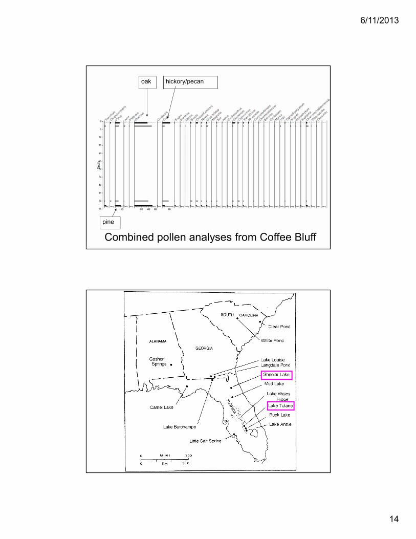
Coffee Bluff, Georgia
upper 1/3
lower 2/3
Pollen percentage diagram
(initial work by Peteet)
6/11/2013
14
Combined pollen analyses from Coffee Bluff
oak
pine
hickory/pecan

6/11/2013
15
Ground-Penetrating Radar

6/11/2013
16
Reflection occurs at an interface or contact between materials which differ in relative dielectric permittivity (RDP)
Carsulae baths, Umbria, Italy

6/11/2013
17
Via Flaminia

6/11/2013
18
Ciotti trench (Forum)
N →
80 cmbs

6/11/2013
19

6/11/2013
20
N

6/11/2013
21
Sunset Hill Cemetery
• Founded in 1861• Initial 30 acres on property donated by
Charles Ogden Force• First interment was Dr. T. W. Ellis in
February, 1861• African American section was opened in
1892 on a 6 acre tract to the north and northeast of the initial 30 acres
• African American section was separated from the white section by a fence during much of the 20th century

6/11/2013
22
“Slave” Section
• During the late 1930’s or early 1940’s, a local woman alerted African American workers to what she had been told was an area of “slave” graves
• Grave digging was halted in that section of Sunset Hill Cemetery
• In 1995, the slave section was commemorated with a granite memorial archway
• In 2004, Sunset Hill Cemetery was listed on the National Register of Historic Places
Profile running South to North (NS)

6/11/2013
23
NS SLICE 6
N
EW SLICE 6
N

6/11/2013
24
NS SLICE 6
20-24 ns
1.6-1.92 m
5.3-6.2 feet
Sunset Hill GPR• At shallow depths, signals show a few
rounded disturbances which are most likely ant beds.
• The lowest time slices show round features which are most likely old pine tree tap roots
• Around 1.2-2m (5.5-6.5ft), larger rectangular anomalies were found that are most likely graves.
• The exact age and identity of these anomalies will be further investigated in cooperation with Sunset Hill Cemetery

6/11/2013
25
LakeTobesofkee

6/11/2013
26
Dixon-Rainey Cemetery
• mid- to late-20th century
• on property along Tobesofkee Creek owned and farmed by the same family up until it was sold to Bibb County in 1960’s
• now part of Sandy Beach Park
• grandson of the last landowner recalled visiting the cemetery as a child
• had informant information from older relatives regarding individuals interred, location of trees, etc….
• one acre site identified using historic maps
NE
SE
SW
NW

6/11/2013
27
Results
• 18 “cultural” anomalies (graves?) • clustered in the area traversed by GPR
profiles 16-40• between 25 m and 45 m from the
baseline on the project grid• 8 “natural” anomalies, at least two of
which match locations for trees identified by informants or shown on historic photographs
• UTM grid coordinates were recorded for all anomalies with the total station

6/11/2013
28