Embed Size (px)
Citation preview

Guidebook For The
67th Annual Reunion of the Friends of the Pleistocene MAY 21-23, 2004, Great Bend, Pennsylvania
Late Wisconsinan Deglaciation Of the
Great Bend - Tunkhannock Region Of Northeastern Pennsylvania
Guidebook Editor: Duane Braun Geography & Geosciences, Bloomsburg University. Field Trip Leaders:
Duane Braun Geography & Geosciences, Bloomsburg University. Jack Ridge Geology, Tufts University Jon Inners Pennsylvania Geological Survey
Logistics: Ruth Braun Geography & Geosciences, Bloomsburg University. Cynthia Venn Geography & Geosciences, Bloomsburg University. Host: Geography & Geosciences, Bloomsburg University. Headquarters: Colonial Brick Motel, Hallstead, PA Guidebook distributed by: Duane Braun / FOP 2004 Geography & Geosciences Bloomsburg University 400 East 2nd Street Bloomsburg, PA 17815 [email protected]
ii
TABLE OF CONTENTS
Quaternary History of the Tunkhannock - Great Bend Region …………………….. 1 Bedrock Geology of the “Endless Mountain” in the Field Trip Area……………….. 8 First day (Saturday) field trip route map……………………………………………… 17 First day field trip road log……………………………………………………………… 18 Stop 1. Bucks Falls post glacial gorge……………………………………… 20 Stop 2. Stevens Point readvance sequence……………………………….. 23 Stop 3. Varves of Glacial Lake Great Bend………………………………… 25 Stop 4. Till knob lodgment till……………………………………………….. 36 Stop 5. Starrucca Viaduct…………………………………………………….. 38 Stop 6. Oakland Esker………………………………………………………… 41 Second day (Sunday) field trip route map…………………………………………….. 45 Second day (Sunday) field trip road log……………………………………………….. 46 Stop 7. New Milford meltwater sluiceway…………………………………… 48 Stop 8. Glacial Lake Bowman bottomset beds……………………………. 53 Stop 9. Glacial Lake Bowman topset beds…………………………………. 56 Stop 10. Moraine on floor of Susquehanna valley…………………………… 58 Stop 11. Tunkhannock viaduct………………………………………………… 59 Stop 12. Beaded valley overview……………………………………………… 63 References……………………………………………………………………………….. 65 List of Previous Field Trips……………………………………………………………… 68 List of Participants……………………………………………………………………….. 71
ACKNOWLEDGEMENTS The organizers of the field trip would like to thank those who gave permission to enter private property and/or took time to open gates for us: American Asphalt Co. – Michael Guida, Jr., Masters Ready Mixed Concrete Co. – Robert Masters, David Adams of Quakertown, PA, Robert Buck of Starrucca, PA, Michael Grossman of Belvidere, N.J., Ted Jadick of Sugar Creek, PA, and John Maxwell of Willow Grove, Pennsylvania. The organizers of the field trip would also like to thank the Geography and Geosciences Department, Bloomsburg University, for providing Van transportation on Saturday.

1
Quaternary History of the Tunkhannock - Great Bend Region
by Duane D. Braun Overview During the Quaternary, the Tunkhannock - Great Bend was affected by a climate that alternated between cold, glacial-periglacial conditions and warm, humid-temperate interglacial conditions. About ten such alternations have affected northeastern Pennsylvania during the last one million years (Braun, 1989, 1994, 1997). There is evidence for four different glacial advances across the Tunkhannock - Great Bend area in that there are three different aged glacial limits mapped southwest of the area (Figure 1)(Braun, 1994; Sevon and Braun, 1997) with a fourth limit now being separated out (Braun, 1999 & ongoing work). The farthest to the southwest and oldest glacial limit is considered to be of pre-Illinoian-G age (850 Ka) (Braun, 1994) or even 2 Ma age (Stanford, 1997). The next distinct glacial limit is considered to be of either late Illinoian (150 Ka) or pre-Illinoian-B (450 Ka) age and is only about 15 kilometers (10 miles) beyond the most recent, late Wisconsinan-age (26 Ka) glacial limit. Other glacial advances have approached the area and caused severe periglacial activity (Braun, 1989, 1994, 1999).
Figure 1. Location map noting drainage patterns, regional ice flow direction, and glacial limits. Arrows show regional ice flow direction. B - Binghamton, D - East - west regional divide, GB - Great Bend, S - Scranton, SR - North Branch Susquehanna River, T - Tunkhannock.

2
Each glacial advance across the Tunkhannock/Great Bend area would have accomplished some erosion. The older glacial termini are parallel to the Late Wisconsinan terminus (Figure 1) and glacial striations in the area covered by the older glaciations are in the same direction as striations within the late Wisconsianan limit (Braun, 1994). This indicates that the older glaciers moved across the region in about the same direction as the late Wisconsinan ice and that they should have eroded and deposited in a pattern generally like that of the late Wisconsinan. Preglacial valleys oriented near parallel to the ice flow would be significantly scoured and partly back filled in each glaciation. Valleys oriented transverse to ice flow would be the least scoured and the most back-filled, sometimes becoming completely buried. The meltwater sluiceways discussed below were probably initiated by the earliest glaciation and enlarged by each succeeding glaciation.
Only late Wisconsinan-age deposits and constructional landforms have been observed in the Tunkhannock - Great Bend area and elsewhere within the late Wisconsinan limit in northeastern Pennsylvania (Braun, ongoing mapping). The last glacial advance was quite effective in removing older glacial deposits, presumably of similar thicknesses to those of late Wisconsinan age, from the landscape. The till deposits are dominated by fresh clasts of the local bedrock; indicating considerable Wisconsinan erosion of the bedrock. Older deposits may still exist under the late Wisconsinan deposits where glacial scour was minimal, such as in valleys transverse to ice flow.
The total duration of Late Wisconsinan ice cover is on the order of 8,000 to 10,000 calendar years at the northern boundary of Pennsylvania and 2,000 to 3,000 calendar years at the terminus in north-eastern Pennsylvania. The late Wisconsinan ice advanced across the Buffalo, New York area at 24.5 Ka (C14 years) (Muller and Calkin, 1993) or 27-28 Ka calendar years (Ridge, 2003) and probably entered Pennsylvania at about 23 Ka (C14 years) or about 27 Ka calendar years. The glacier reached its terminal position at about 22.8 Ka (C14 years) in New Jersey (Cotter et. al., 1986) or 25.8 - 26.8 Ka calendar years (Ridge, 2003) and probably also in Pennsylvania. Retreat from the terminal position started around 19Ka (C14 years) (Cotter et. al., 1986) or 22.1 - 22.9 Ka calendar years (Ridge, 2003) and reached the Finger Lakes at about 16 Ka (C14 years) (Muller and Calkin, 1993). Cadwell (1973) obtained a bulk 16.6 +- 1.8 Ka C14 date from a bog bottom just north of Binghamton New York. Bulk bog and lacustrine C14 dates are often 1000 -2000 years too old (Ridge et. al. 1999), so subtracting the 1.8 Ka error from the 16.6 Ka date probably gives the best C14 age to use or 14.8 Ka (C14 years). A reasonable estimate then for ice recession to reach the Pennsylvania - New York State line is about 15 or so Ka (C14 years) or 18 Ka calendar years. This means that it took 3000 to 4000 calendar years, say 3500 years, for the ice to retreat the 110 kilometers (70 miles) (along a S 200 W flow-line) from the terminal moraine through Tunkhannock and Great Bend to the New York line. If the ice retreated at a steady rate (assuming no significant readvances) it would have taken about 32 calendar years to recede one kilometer (50 years per mile). At that rate, the ice would have crossed a single 7.5’ quadrangle in about 425 calendar years and retreated from Tunkhannock to Great Bend in about 1500 years.
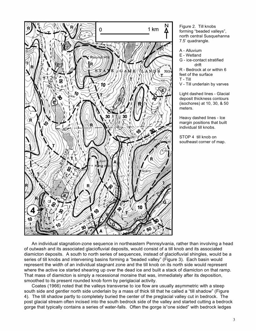
Ongoing mapping by Braun of the glacial deposits in northeastern Pennsylvania suggests that several (5 to 15) short lived still-stands of the glacier occurred as it receded across an individual 7.5’ quadrangle. During each still-stand the ice deposited a belt of thicker material, usually expressed in each valley as a 30 to 50 meter thick till knob damming the valley. Coates and King (1973) and Coates (1981), working within and just north of the Great Bend area, also described till knobs that partly block many small tributary valleys and impound lakes and swamps. From well data, primarily in New York, till thickness in the valleys averaged 18 meters (60 ft.), was often over 30 meters (100 ft.) especially under knobs, and was in a few places 75 meters (250 ft.). Similar thicknesses of till are shown by thickness contours on the 7.5’ quadrangles mapped by Braun in northeastern Pennsylvania.
A series of such till knobs form “beaded valleys” that have a series of narrower and wider segments (Figure 2). From the time estimates above, each of these belts of thick till or valley damming knobs should have taken on the order of 30 to 85 years to form. The spacing of these till knobs is similar to the heads of outwash left by stagnation-zone retreat in New England (Koteff, 1974; Koteff and Pessl, 1981). This suggests a similar stagnation-zone retreat style of deglaciation in northeastern Pennsylvania in a "till rich" environment rather than the "outwash rich" environment in New England or farther north in the Susquehanna drainage basin in New York.
3
An individual stagnation-zone sequence in northeastern Pennsylvania, rather than involving a head of outwash and its associated glaciofluvial deposits, would consist of a till knob and its associated diamicton deposits. A south to north series of sequences, instead of glaciofluvial shingles, would be a series of till knobs and intervening basins forming a “beaded valley” (Figure 3). Each basin would represent the width of an individual stagnant zone and the till knob on its north side would represent where the active ice started shearing up over the dead ice and built a stack of diamicton on that ramp. That mass of diamicton is simply a recessional moraine that was, immediately after its deposition, smoothed to its present rounded knob form by periglacial activity.
Coates (1966) noted that the valleys transverse to ice flow are usually asymmetric with a steep south side and gentler north side underlain by a mass of thick till that he called a “till shadow” (Figure 4). The till shadow partly to completely buried the center of the preglacial valley cut in bedrock. The post glacial stream often incised into the south bedrock side of the valley and started cutting a bedrock gorge that typically contains a series of water-falls. Often the gorge is“one sided” with bedrock ledges
Figure 2. Till knobs forming “beaded valleys”, north central Susquehanna 7.5’ quadrangle. A - Alluvium E - Wetland G - ice-contact stratified drift R - Bedrock at or within 6 feet of the surface T - Till V - Till underlain by varves Light dashed lines - Glacial deposit thickness contours (isochores) at 10, 30, & 50 meters. Heavy dashed lines - Ice margin positions that built individual till knobs. STOP 4 till knob on southeast corner of map.

4
on its south side and till on its north side. Such a one sided gorge will be visited at STOP 1 and several examples of such gorges are noted on the road log of the field trip. Sometimes the burial of the transverse valley is so deep that the post glacial stream is diverted to an adjacent valley.
As the glacier continued its recession north of Pennsylvania, cold periglacial climatic conditions prevailed in the area for several thousand years. At that time, the exposed sandstone ledges were frost riven and shattered (Peltier, 1949; Harrison, 1966) and the blocks transported downslope by various processes collectively known as gelifluction (Coates and King, 1973; Coates, 1981; Braun,
Figure 3 Cross-section sketch of a stagnation-zone retreat model for till knob deposition. A. Successive active ice zones stacking till on the north side of each dead ice zone. B. Resulting till knob - basin “beaded valley” landscape.
Figure 4. Cross-section sketch of an asymmetric valley transverse to ice flow showing a “till shadow” on the north side of the valley and post glacial stream incision along the south side of the valley. C - Colluvium AT - Ablation till LT-DT - Lodgement & deformation till

5
1994, 1997). These processes resulted in a boulder colluvium mantle often extending 150 meters (500 feet), and in places, as much as 300 meters (1000 feet), downslope of individual sandstone ledges. A number of exposures show late Wisconsinan till or ice-contact gravel under the boulder colluvium. The glacial till deposits themselves have been “mobilized” on the slopes by gelifluction (Braun, 1994, 1997). On the upper to middle parts of the slopes, the upper 0.5 to 1.0 meter (2 to 3 feet) of material is colluvium derived from till. The material often shows a well-developed downslope fabric (tabular clasts near parallel to the ground surface). On the lower parts of the hillslopes the “colluviated till” is often 2 meters to 5 meters (6 -15 feet) thick.
In northeastern Pennsylvania, post glacial fluvial erosion of the till mantled slopes was also significant as shown by numerous alluvial fans in the region. The fans are best developed where small, steep gradient streams enter the broad floors of the ice scoured, near parallel to ice flow trunk valleys. Hundreds of such fans have been mapped in the region.
In the latest Pleistocene, after 13,000 BP (Dalton and other, 1997), forest vegetation became well established in the area. This acted to reduce erosion and sediment load of tributary streams while trunk streams continued to incise into the glacial deposits. In the Holocene the only areas of significant sediment deposition have been on the floodplains of the larger streams in the region, such as the North Branch Susquehanna. Those deposits are primarily overbank deposits that drape the lower portions of the outwash terraces. Small scale climatic changes during the Holocene are reflected in changes in the rate of that overbank sedimentation. Course of Susquehanna River’s affect on deglaciation of the area
The convoluted course of the North Branch Susquehanna River caused meltwater to be ponded in front of the receding ice in places while in other places the meltwater could freely drain away from the ice. From its New York State headwaters, the river flows southwest to Pennsylvania where it makes a near 1800 “Great Bend” to re-enter New York State flowing northwest (Figure 1). The river then flows west until it makes a more than 900 bend to re-enter Pennsylvania and flow southeast in a series of large incised meanders past Tunkhannock to the northern Anthracite syncline (Wyoming Valley). Between Tunkhannock and Great Bend is a east - west trending regional divide separating streams draining north to Great Bend and New York State from those draining south to the incised meander reach. The northerly draining tributaries on the west side of the incised meander reach and north of the east - west divide contained proglacial lakes during deglaciation. Deglaciation of the Tunkhannock area
The southeast trending incised meander reach of the North Branch Susquehanna River was parallel to the edge of glacier as it retreated from the area. When the ice front reached the river valley, ice marginal meltwater drainage cut a series of channels and incised cols on the southwest side of the valley (Figure 5). Additional drainage came from ice dammed lakes in tributaries that enter the southwest side of the Susquehanna valley. Before the ice front reached the Susquehanna valley, those lakes only had outlets near their headwaters and had high elevation water levels. As the ice retreated into the Susquehanna valley, those lake levels dropped 10’s to 100’s of meters and sent large quantities of water along the southwest side of the Susquehanna valley.
This ice marginal drainage built large deltas in the mouths of the dammed tributary valleys. The largest of these deltas was built into Glacial Lake Bowman near where the Bowman Creek valley enters the Susquehanna valley just south of Tunkhannock. (D on Figure 5). The delta was fed by two different meltwater sluiceways (Figure 5). The western sluiceway has an especially deeply incised col that carried flow from Glacial Lake Mehoopany when that lake’s level dropped about 200 meters (650 feet) as ice retreated to the Susquehanna valley. STOP 8 will examine the bottomset beds of the delta. STOP 9 will examine the topset beds of the delta and a boulder bed capping the topsets.
Once the ice front of the glacier retreated northeast of the Susquehanna valley, meltwater built a series of outwash terraces on the floor of the valley. Both White (1883) and Peltier (1949) noted several terrace levels in the Tunkhannock area. The current mapping (Braun, 2002) generally agrees with the terrace levels observed by previous workers but revises the elevation and interpretation of some of those levels. White’s 60 meter (200 ft.) and 45 meter (150 ft.) terraces are ice marginal channels. Peltier’s 30 meter (100 ft) level kame terrace under much of the town of Tunnkhannock is

6
actually the main outwash terrace found at a number of sites along the river in the area and should properly be called the “Olean” terrace. Peltier’s 23 meter (75 ft) Olean terrace is actually the next to highest glacial outwash terrace and is more properly related to ice margin positions farther north than those that produced the 30 meter terrace. Peltier’s 14 to 15 meter (45 - 50 ft) terrace is present in the mouths of tributary valleys. This terrace is probably related to the latest glacial to post glacial down cutting of the river rather than the Valley Heads ice margin in New York State. Peltier’s lowest 8 to 9 meter (25 - 30 ft) high terrace and White’s lowest 9 to 11 meter (30 - 35 ft) terrace are both related to the post-glacial incision of the river.
Shaw (1989) proposed that the Susquehanna valley should be examined for evidence of catastrophic discharges on the order of 106 m3/s. Such discharges are hypothesized to come from subglacial floods that formed drumlins and other features in New York State and Ontario (Shaw, 1989; Shaw and Gilbert, 1990). Shaw's technique of estimating drumlin-forming discharges yields a peak discharge of 4.8 x 10⁶ m3/s. Several of these floods supposedly occurred from 14 to 16 Ka (C14 years), when the terminus of the Wisconsinan ice sheet was between Binghamton, N.Y. and the southern end of the Finger Lakes.
Braun (1990), using the Channeled Scabland channels as a model, calculated that a flood of that size would require water depths in excess of 150 meters (500 feet) above the floor of the Susquehanna valley. Braun (1990) noted a number of features in the Susquehanna valley from Bloomsburg to Tunkhannock that show flood levels were never more than 10 to 15 meters (a few 10’s of feet) above the surface of the highest outwash deposits. Two miles south of the town of Tunkhannock is an extensive area of knob and kettle morainic topography that lies just 12 meters (40 ft) or so above the 30 meter terrace surface (STOP 10). This means that only a flood 12 feet deep could have come down the river, less than 10 % of depth of Shaw’s proposed flood.
Figure 5. Map showing the incised meander reach of the Susquehanna River near Tunkhannock (T). Lines with hachures are successive ice margins that forced meltwater drainage through a series of sluiceways (arrows) on the southwest side of the valley. D - Bowman valley delta (Stop 8 & 9), C - Deep sluiceway to west side of the delta, LB - Glacial Lake Bowman, LM - 300 meter level Glacial Lake Mehoopany. HLM - 500 meter level Glacial Lake Mehoopany. Elevations of contours and sluiceways are in meters.
LB
H L M
LM

7
Deglaciation of the Great Bend Area As the glacier retreated from the Tunkhannock to Great Bend, meltwater was free to drain away from the ice down south draining valleys until it reached the regional east - west divide near New Milford. Once the ice retreated north of the divide, a series of proglacial lakes developed in each of the north draining valleys (Figure 6). As the ice continued retreating north of Great Bend, the individual lakes combined into the regional Glacial Lake Great Bend when the Susquehanna valley opened up in the Great Bend area (Figure 6). This proglacial lake extended for 40 kilometers (25 miles) along the Susquehanna valley and up all the tributary valleys. Its outlet was through New Milford and down Martins Creek to Nicholson, the New Milford sluiceway (Harrison, 1966). The meltwater carved a 180 meter (600 ft) deep notch through the east - west divide (STOP 7). The 5 ice margins shown on Figure 6 represent different phases in the development of Glacial Lake Great Bend and its deposits. Ice margin 1 was when the ice was right at the entrance to the New Milford sluiceway and meltwater was still draining freely
to the south. As the ice receded up Salt Lick Creek valley from margin 1 to margin 2, it deposited the sand and gravel deposits on the floor of the valley. Margin 2 is marked by a hanging delta (D on Figure 6) on the west side of the valley that is graded to the level of the lake. The next margin, 3, is marked by a hanging delta and a sluiceway channel that extends from the next valley to the east and is graded to the level of the lake. Margin 4 was where the ice first started to “open up” the Susquehanna Valley and permitted expansion of Glacial Lake Great Bend into valleys to either side of the sluiceway valley. This expansion process continued until the lake reached its maximum size at ice margin 5. Once the ice receded north of margin 5, the lake would have drained as meltwater freely flowed westward down the Susquehanna Valley at Binghamton, New York.
Outcrops of varves exist in tributary valleys adjacent to the Susquehanna valley throughout the area of Glacial Lake Great Bend. The varves in the Susquehanna valley are below present river level as shown by well data in the New York portion of the valley (Randall, personnel communication). All the varves are between a basal till unit and thick overlying till and ice-contact stratified drift units. This indicates that there was a significant readvance of the glacier across the entire Great Bend area to near the east - west divide before the glacier finally retreated entirely from the region.
Figure 6. Map showing Glacial Lake Great Bend at it’s greatest extent (shaded area). The five hachured lines are successive ice margins of the retreating glacier that mark different phases in the development of the lake. B - Binghamton, Di - east-west trending regional divide, GB - Great Bend borough, NM - New Milford, S - Glacial striations SL - New Milford sluiceway, SR - North Branch Susquehanna River, Small D’s - Hanging deltas. Sluice divide - 350 meters (1140-1150 ft).

8
BEDROCK GEOLOGY OF THE “ENDLESS MOUNTAINS” IN THE FIELD TRIP AREA
by Jon D. Inners, Pennsylvania Geological Survey
The “Endless Mountains” occupy the northeastern part of the Allegheny Plateau in Pennsylvania. Except for a few high ridges that reach elevations of over 2500 feet (e.g., Elk Mountain and East Mountain in Susquehanna County and Mount Ararat and Sugarloaf Mountain in Wayne County), these “mountains” in the field trip area are actually rounded, “plateau” hills 1300 to 1800 feet high, their summits standing in relief 300 to 500 feet above deeply incised stream valleys. The name “Endless” may be a bit of a “geographic misnomer” (see Inners and Fleeger, 2002), being a translation of the Delaware Indian word kittatinny (Donehoo, 1928) that is better applied to the elongate Valley and Ridge mountains (e.g., Kittatinny Mountain in New Jersey). However, the designation “Endless Mountains” does appear on Lewis Evans’ 1755 map east of present-day Williamsport—and on a map of Pennsylvania published in London in 1775, the “Endless Mountains” are shown as being in approximately the same area as the name is applied today (Petrillo, 1991). Perhaps the name is not so inappropriate after all!
STRATIGRAPHY Within the route of the field trip, the “Endless Mountains” are entirely underlain by relatively flat-lying
terrestrial and nearshore marine rocks of the Late Devonian-age Catskill Delta. The delta prograded in a general west-northwest direction, so that the shoreline became progressively younger in that direction (Harper, 1999, Fig. 7-21). In general, terrestrial/nonmarine strata greatly predominant in the east and southeast, with outcropping marine strata becoming significant to the west and northwest (see Figure 18). A rather uniform, gentle southward structural dip results in the oldest deltaic strata being exposed along the New York-Pennsylvania border.
Figure 7 summarizes the stratigraphic relations of the Upper Devonian rocks of the “Endless Mountains” and adjacent areas. The Trimmers Rock, Brallier, and Lock Haven Formations represent offshore-marine sedimentary environments; and the Great Bend Member of the Catskill Formation, the lowermost part of the Towamensing Member (Sevon et al., 1989), and the lower part of the Catskill Formation, undivided) include shoreline deposits. All the other stratigraphic units are entirely terrestrial. Only the rocks in Susquehanna and northern Wayne Counties will be discussed in detail here.
. Figure 7. Stratigraphic relationships of Upper Devonian rocks in the “Endless Mountains”
(Berg et al., 1981; Inners, [2002]; McElroy, [2002]; Sevon et al., 1989)

9
Lock Haven Formation
The Lock Haven Formation consists predominantly of interbedded medium- to thick-bedded, gray sandstone, siltstone, and shale (Figure 8). The sandstones are typically crossbedded, rippled, and graded (fining-upward). Marine fossils (brachiopods, bivalves, crinoid columnals, etc.) are locally abundant, often being concentrated in lenticular coquinite beds up to a foot or more thick in the lower parts of sandstone beds. The most noteworthy sedimentary structures in the Lock Haven are the ball-and-pillow structures that occur at many outcrops, the series of deep cuts on the Norfolk Southern (formerly Erie) Railroad east of Great Bend having the most spectacular examples (Figures 9 and 10).
Total thickness of the Lock Haven Formation is probably at least 3,000 feet, but only the uppermost 500+ feet is exposed in the field trip area.
Figure 8. Typical stratigraphic section in the Lock Haven Formation, Fall Brook gorge of Salt Spring State Park, 1.0 mile southwest of Franklin Forks, Susquehanna County (Inners, Braun, Adelman, and Kochanov, 2002, p. 118).

10
Figure 9. Generalized stratigraphic section of Lock Haven Formation exposed along the Norfolk Southern Railroad tracks, 1.25 miles east of Great Bend. Note the submarine-slide horizons and the numerous ball-and-pillow structures (Inners, Woodrow, and McElroy, 2002, p. 111).
Figure 10. Ball-and-pillow structures in the Lock Haven Formation near the west end of the railroad cut east of Great Bend.

11
Catskill Formation The Catskill Formation of northeastern Susquehanna County has recently been divided into two
members, a lower Great Bend Member and an upper Lanesboro Member (Inners, [2002]; McElroy, [2002]). The most significant difference between the members is the presence of marine invertebrate fossils at several horizons in the Great Bend and their total absence in the Lanesboro. Both are the source of high quality “bluestone.” The dimension stone for the Starrucca Viaduct (1848) came from the lowermost sandstone unit in the Great Bend Member at Stevens Point (Inners and Braun, 2002; Young, 1995), and the presently active quarries of the Endless Mountain Stone Co. south of Susquehanna are situated in the lower Lanesboro Member (Inners and MacDonald, 2002). Great Bend Member. The lower 350+ feet of the Catskill Formation is composed of interbedded gray sandstone and shale and red siltstone, mudstone, and shale, the lithic units being arranged in cyclic marine and non-marine sequences 30 to 60 feet thick (Figure 11). Marine fossils (brachiopods, crinoid
Figure 11. Typical stratigraphic section in the Great Bend Member of the Catskill Formation, “Starrucca Viaduct” (Grover’s) quarry at Stevens Point, Susquehanna County (Inners and Braun, 2002).

12
columnals, and bivalves) occur mostly in thin, lenticular coquinites in the gray sandstones and as thin concentrations in some gray shale beds (see Inners and Braun, 2002). The gray sandstones typically occur in multistorey units (Figure 12; see Bridge and Gordon, 1985; Bishuk et al., 2003) and are predominantly thick to very thick bedded, medium gray to medium light gray, and fine to medium grained. Typically the lower parts of the gray sandstone “storeys” tend to be relatively planar bedded (often appearing massive) and the upper parts trough crossbedded (see also Sevon et al., 1989). Prominent parting step-lineation in the planar-bedded sandstones is the result of high-velocity fluid flow over fluvial and offshore bars and through the shallow channels of distributaries and coastal/deltaic rivers (Figure 13; see Bishuk et al., 2003, and Krajewski and Williams, 1971). The planar-bedded portions yield the prime “bluestone”—primarily dimension stone if massive and flagstone if readily split along closely spaced parting planes. Also occurring in the Great Bend Member are concentrations of carbonized plant debris (Figure 15), shale-chip conglomerates, and calcareous “agglomerates.” The latter two are described and illustrated below with the Lanesboro Member, in which such units are thicker and more common.
Figure 12. Highwall in “bluestone” quarry showing multistory sandstone units in the Great Bend Member, R. Bishop permit on ridge northwest of Pigpen Creek, 1.5 miles northeast of Lanesboro, Susquehanna County.
Figure 13. Parting step-lineation—oriented N30oW-S30oE—in “bluestone” of the Great Bend Member, same quarry as Figure 12.

13
Lanesboro Member. The Lanesboro Member consists of 30- to 60-foot thick, totally non-marine, cyclic sequences of gray sandstone and shale and red sandstone, siltstone, mudstone, and shale (Figure 14). As in the underlying Great Bend Member, the thick, gray sandstones in the Lanesboro are typically multistory, the “storeys” showing an upward change from planar bedded (and rather massive) to trough crossbedded. Parting step-lineation is ubiquitous in the planar-bedded sandstones, varying greatly in orientation but averaging roughly east-west (Inners, 2002). The Lanesboro contains abundant carbonized plant debris, locally occurring as “logjam” concentrations of coaly trunks and limbs. Lenticular beds of shale-chip conglomerate several inches thick occur at the base of many sandstone units; locally these contain flattened, “boulder-size” clasts (Figure 16). The “agglomerates” or “calcareous breccias” (White, 1881) in the Lanesboro (Figure 17) are probably lag deposits of pedogenic calcrete that resulted from the erosion and slumping of cut banks along low-sinuosity streams on the lower delta plain of the prograding Catskill clastic wedge (Bridge and Gordon, 1985).
Thickness of the mapped Lanesboro Member in northeastern Susquehanna County is about 1000 feet (Inners, [2002]).
Figure 14.Typical stratigraphic section in the Lanesboro Member of the Catskill Formation: Coleman quarry of Endless Mountain Stone Co., 1.75 miles southwest of Susquehanna, Susquehanna County (Inners and MacDonald, 2002).

14
Figure 15. Carbonized plant debris on base of flaggy sandstone bed in the Great Bend Member, loose block in New Milford Sand & Gravel Co. stone quarry, north side of SR 1018, 0.4 mile west of Tingley, Susquehanna County.
Figure 16. Large gray-shale clasts at the base of a sandstone channel in the Lanesboro Member, abandoned “bluestone” quarry east of SR 1011 about 1.5 miles south of Stevens Point, Susquehanna County.

15
STRUCTURE The “Endless Mountains” occur within an unfolded to very gently folded part of the Appalachian
Plateaus province. As shown in Figure 18, mapped folds are almost entirely restricted to Wayne County in the east and Bradford and Wyoming Counties in the west; only the northeastern end of the Milton anticline and the eastern terminations of the Windham syncline and Rome anticline enter Susquehanna County. Throughout much of the eastern and central part of the region, the rock strata are inclined rather uniformly toward the south at 50 to 100 feet per mile (see McElroy, [2002]; Inners, [2002]; and Kochanov, [2002]). Local deviations from this general regional structure—with dips as high as 10o in various directions—occur at numerous places, but these relatively steep bedding dips cannot be related to mappable folds.
Systematic joints are well developed in both the Lock Haven and Catskill Formations. Major sets are oriented approximately north-south and east-west (Figure 19); Inners, 2002), a pattern that persists southeastward to the Delaware River (Sevon et al., 1989; Inners and Osborne, 2001). The “north-south” joints are generally planar, continuous, locally quartz mineralized, and spaced 3 to 15 feet apart. The less regular “east-west” set is commonly wavy, less continuous, and non-mineralized. Many of the quarries, e.g., those of Endless Mountain Stone Co. near Susquehanna, make use of these natural fractures in quarrying out blocks that are later cut to prescribed specifications in preparation shops (Inners and MacDonald, 2002).
Figure 17 A. Residual block of calcareous “agglomerate” derived from the Lanesboro Member, on south slope of Penn Hill, about 1.25 mile northeast of Starrucca, Wayne County. Figure 17 B. Close-up of “agglomerate” block.

16
Figure 18. Generalized geologic map of the field trip area, showing mapped structural axes (after Berg, 1980, and Faill, no date). Stratigraphic units: Dlh = Lock Haven Formation; Dck = Catskill Formation; MDhm = Huntley Mountain Formation; IPp = Pottsville Formation; IPl = Llewellyn Formation. Fold axes: WS = Windham syncline; RA = Rome anticline; LS = LeRaysville syncline; TA = Towanda anticline; BS = Barclay syncline; MA = Milton anticline; LaS = Lackawanna syncline. GB = Great Bend; S = Susquehanna; St = Starrucca; M = Montrose; N = Nicholson; T = Tunkhannock. NB = North Branch Susquehanna River; EM = Elk Mountain.
Figure 19. Joints in “bluestone” of the Lanesboro Member of the Catskill Formation, northern part of same quarry as Figure 15. The sunlit joints are the “north-south” set, shaded ones the “east-west” set.

17
Saturday’s Field Trip Route Map
and the Beginning of Sunday’s Trip Route Map
Figure 20. First day (Saturday) trip route from Great Bend (GB) eastward along the North Branch Susquehanna valley to the village of Susquehanna and then southeastward along Starrucca Creek. For almost the entire trip one will be under the water level of Glacial Lake Great Bend or Glacial Lake Starrucca. On the second day (Sunday) the trip will run southward from Great Bend and down the outlet of Glacial Lake Great Bend, the New Milford sluiceway.

18
DAY 1 ROAD-LOG AND STOP DESCRIPTIONS Miles Int. Cum. Description 0.0 0.0 Leave the Colonial Brick Parking lot, continuing straight ahead at the traffic light onto PA 171. 0.1 0.1 Pass under I-81. 0.3 0.4 Pass over Norfolk Southern Railroad tracks (the old Erie grade from the Starrucca Viaduct). For the
entire trip to Stop 1 we be following the North Branch Susquehanna Valley and Starrucca Creek Valley and we will be under the 1200 feet or so elevation water-level of Glacial Lake Great Bend.
0.7 1.1 Great Bend Township Municipal Building to right. Brant’s Dairy Bar to left, ascend hill. 0.2 1.3 To right is a cut in gray, fossiliferous Lock Haven sandstone and shale. 0.9 2.2 To right is a good view of the North Branch valley, where the post-glacial Susquehanna cut through
the bedrock spur of a preglacial incised meander loop (the old valley swings around in the background to the south). Sheer sandstone cliffs (Lock Haven Formation) still descend down to the river on the far side, but on the north side construction of the Erie Railroad destroyed the “original beauty of this once interesting spot” (Blackman, 1873). In the days of early settlement this area was known as the “Painted Rocks” or the “Red Rock,” because of Indian paintings on the ledges. The bedrock here also slowed the post-glacial incision of the river and only the highest terraces upstream of here are outwash, all others are alluvial terraces of very latest Pleistocene to Holocene age.
0.3 2.5 To left is a low cut in Lock Haven sandstone, descend into North Branch Susquehanna valley. 0.1 2.6 Village of Red Rock sign. 1.7 4.3 Village of Hickory Grove, intersection with SR 1025 on the left. 0.2 4.5 On left is a modernistic “Falling-water-like” home with an ephemeral stream channel passing
underneath the center portion of the house. 0.1 4.6 For the next two miles or so the N. Br. Susquehanna valley trends transverse to glacier flow and the
hillside to the left is a “lee” slope where a thick “till shadow” was deposited. Preglacial first order tributary hollows cut into that slope are filled with more that 60 meters (200 ft.) of till (see Day-1 Roadlog map).
0.6 5.2 To left is an abandoned channel of the N. Br. Susquehanna River. Ascend onto a terrace surface 15 meters (50 ft.) above the present river and 10 meters (30 ft.) below the top of the bedrock gorge 4.8 km (3.0 mi.) downstream. The terrace is interpreted to be a post-glacial (latest Pleistocene-earliest Holocene) strath cut across an older, higher outwash terrace.
0.3 5.5 Oakland Township sign. 0.4 5.9 To right is Tower SR of the old Erie Railroad. The building was originally filled with manual switching
and signaling elements (“Johnson bars,” etc.). Most of this was replaced by more automated machinery in later years.
0.4 6.3 To right is the Aaronic Priesthood Restoration Site, a shrine of the Church of Jesus Christ of the Latter-day Saints. It was here on the homestead of his father-in-law, Isaac Hale, that Joseph Smith (1805-1844), the founder of Mormonism, translated most of the book of Mormon in 1828-29 (from gold plates found in a drumlin in north-central New York). Several plaques and monuments at the site tell the story in considerable detail. Buried in the adjacent McCune Cemetery are Isaac Hale (1763-1839) and his wife, Mary (1766-1842), and Joseph and Emma Hale Smith’s infant son, Alvin (d. June 15, 1828)
0.7 7.0 Pass through Lanesboro-Oakland Esker. A small abandoned pit to left used to show a good cross section of the esker (Inners, et al., 1999). The esker at this point is composed of two types of material. The northern part is rather evenly stratified, coarse- to very coarse-grained sand containing bands of small to large pebbles. Occupying the southern part and cut into the sandy deposit is a channel filled with poorly sorted, poorly bedded, pebbly to cobbly gravel that has a matrix of coarse to very coarse sand and granules.
0.2 7.2 On right is the entrance to the Red Oak pit of Masters Ready Mixed Concrete Co., cut through almost the entire esker and the site of Stop 6 this afternoon.
0.3 7.5 Enter Oakland and start descending slope to the river. 0.5 8.0 Turn RIGHT onto PA 171/PA 92 and the Susquehanna County Veterans Memorial Bridge and cross
North Branch Susquehanna River. Downstream to right is a low-head hydroelectric dam that impounds the river at this point. The river here is flowing westward at the apex of the Great Bend in the river (see Day-1 Roadlog map).
0.1 8.1 Bridge crosses old Erie Railroad tracks (now Norfolk Southern). To left is the site of the former Erie yards and shops and to right the roof of the former Erie Passenger Station, now a restaurant, and the fire station beyond it. Enter borough of Susquehanna, incorporated as Susquehanna Depot in 1853.