Embed Size (px)
Citation preview

Summary Report of Planning and ManagementPT Dendymarker Indahlestari
Musirawas District – South Sumatera Province, Indonesia
1. Executive Summary
PT Dendymarker Indahlestari (PT DMIL) is a company in Indonesia which hasreceived an “Izin Lokasi” in April 26th 1995 and revised in October 25th 1995 to use aland area of ± 24,000 Ha become ± 19,000 Ha for Inti and Plasma palm oilcultivation. PT DMIL which share held by PT Agro Investama Gemilang is aregistered member of the RSPO with membership number 1-0146-13-000-00.
PT DMIL had conducted a Social and Environmental Impact Assessment carried outby Pusat Penelitian Lingkungan Hidup (PPLH) Universitas Sriwijaya in November2004.
PT DMIL has conducted HCV Assessment carried out in November 2013 bySonokeling Akreditas Nusantara led by Ir. Kresno Dwi Santosa, M.Si. Ir. Kresno DwiSantosa, M.Si is an approved RSPO HCV assessor. PT DMIL had also engagedSonokeling Akreditas Nusantara to carry out Social Impact Assessment in November2013. Result from studies of these SEIA and HCV assessments which have beensummarized were used to formulate this management plan.
PT DMIL has also conducted an Social and Environmental Impact Assessment in2004 and this document has been verified by Badan Lingkungan Hidup Kab.Musirawas No. 660/95/IV/2004 dated on November 9th 2004.
2. Reference Documents
a. SEIA and HCV Assessment Report
SEIA Report PT DMIL by Pusat Penelitian Lingkungan Hidup (PPLH) UniversitasSriwijaya, November 2004
HCV Assessment Report PT DMIL by Sonokeling Akreditas Nusantara,November 2013
SIA Report PT DMIL by Sonokeling Akreditas Nusantara, November 2013 Land Permit PT DMIL: SK Kepala BPN Kab. Musirawas No: 003/SK-
IL/MURA/1995 dated April 26th 1995 and revised by SK Kepala BPN Kab.Musirawas No: 008/SK-IL/MURA/1995 dated October 25th 1995
Konsorsium Revisi HCV Toolkit Indonesia, 2008 Maps of PT DMIL
b. List of Legal Documents and Regularly Permit
No. Kind of Permit/Recommendation Approved by No. and Date Ha
1 Principle Permit Minister ofAgriculture of RI
No: HK.350/E5.770/11.9424 November 1994
34,000 Ha120 ton

FFB/Hours2 Principle Permit Governor of
SUMSELNo: 593/01771/I21 April 1995
± 19,000 Ha
3 Location Permit Head of BPNKab. Musirawas
No: 003/SK-IL/MURA/199526 April 1995
± 24,000 Ha
4 Extension ofLocation Permit
Head of BPNKab.MUSIRAWAS
No: 008/SK-IL/MURA/199525 October 1995
± 19,000 Ha
5 Extension ofPrinciple License ofPlantation Business(PPUP)
Minister ofAgriculture of RI
No: HK.350/E5.275/04.9625 April 1996
6 Extension ofLocation License
Head of LandOffice Kab.MUSIRAWAS
No: 17/SK-ILP/MURA/199714 June 1997
± 19,000 Ha
7 Permit of ReleasingForest Area
Minister ofForestry
No: 3/Kpts-II/19975 January 1998
8 Permit of TimberUtilization
GeneralDirectorate ofConcession ofDEPHUT
No: 372/IV-BPH/19986 March 1998
9 Permit of TimberUtilization
Head ofRegional Officeof Department ofForestry,SUMSELProvince
No: 107/Kpts/Kwl-1/199816 March 1998
10 Right to Cultivate(HGU)
Land Office inMusirawasRegency
No. 4 Tahun 199820 November 1998
17,793.5 Ha
11 Registration ofPlantation Business
Minister ofAgriculture of RI
Nomor: 83/Mentanhut-VII20009 October 2000
17,793.5 Ha60 tonFFB/Hours
12 Plantation-Cultivation BusinessLicense
Regent ofMusirawas
Nomor: 576 tahun 200828 May 2008
13 Processing-Plantation BusinessLicense
Regent ofMusirawas
Nomor: 575 tahun 200828 May 2008
c. Location Maps

Picture 1. Location of PT Dendymarker Indahlestari in Indonesia
Picture 2. Location of PT Dendymarker Indahlestari in South Sumatera Province
Picture 1. Location of PT Dendymarker Indahlestari in Indonesia
Picture 2. Location of PT Dendymarker Indahlestari in South Sumatera Province
Picture 1. Location of PT Dendymarker Indahlestari in Indonesia
Picture 2. Location of PT Dendymarker Indahlestari in South Sumatera Province

Picture 3. HGU Area of PT Dendymarker Indahlestari in Musirawas DistrictPicture 3. HGU Area of PT Dendymarker Indahlestari in Musirawas DistrictPicture 3. HGU Area of PT Dendymarker Indahlestari in Musirawas District

Picture 4. Overlay Map and Status of Forest Plantation PT Dendymarker IndahlestariPicture 4. Overlay Map and Status of Forest Plantation PT Dendymarker IndahlestariPicture 4. Overlay Map and Status of Forest Plantation PT Dendymarker Indahlestari

Picture 5. Overlay Planting Project of PT Dendymarker Indahlestari with RTRWPMusirawas District, South Sumatera Province, Indonesia
Picture 5. Overlay Planting Project of PT Dendymarker Indahlestari with RTRWPMusirawas District, South Sumatera Province, Indonesia
Picture 5. Overlay Planting Project of PT Dendymarker Indahlestari with RTRWPMusirawas District, South Sumatera Province, Indonesia

Picture 6. Overlay Planting Project of PT Dendymarker Indahlestari with MoratoriumRevision 5 (13 November 2013), sesuai SK Menhut No. 6018/Menhut-VII/IPSDH/2013
d. Area and Time-plan for New Planting
PT Dendymarker Indahlestari’s development plan has incorporated the findings fromSEIA (AMDAL) by Pusat Penelitian Lingkungan Hidup (PPLH) Universitas Sriwijaya,and HCV Assessments and Social Impact Assessment by Sonokeling AkreditasNusantara as described above when implementing the operational plans.Management plans for HCV areas and management plans for handling socialimpacts have been drawn up.
The total area located in HGU of PT Dendymarker Indahlestari is 17,793.50 Ha. Thearea has been planted since 1996 is 7,740.50 Ha (Inti: 5,037.40 Ha and Plasma:2,703.10 Ha), proposed new planting areas is ± 6,423.93 Ha (Inti: 6,346.33 Ha andPlasma: 77.60 Ha). The HCV management plan has been developed for these areas± 2,893.50 Ha and there is unplantable areas around ± 735.57 Ha. According theoperational management of PT Dendymarker Indahlestari land development willcommence in year 2013.
PT Dendymarker Indahlestari implemented a system smallholder with Inti: Plasma,which is Plasma are managed by KUD.

Summary of Development Plan as described below:
Permit(Ha) HGU (Ha)
Planted Todate (Ha) HCVArea(Ha)
UnplantableArea(Ha)
Balance Area to be Planted(Ha)
Inti Plasma Total Inti Plasma Total
19,000 17,793.50 5,037.40 2,703.10 7,740.50 2,893.50 735.57 6,346.33 77.60 6,423.93
3. SEIA and HCV Management and Key Personal
a. Organizational Information and Contact Persons
Company Information and Contact PersonCompany Name PT Dendymarker IndahlestariRSPO Membership No. 1-0146-13-000-00Capital Status Domestic Investment (Penanaman Modal
Dalam Negeri – PMDN)Type of Business Oil Palm Plantation and MillAddress:Head Office Karawaci Office Park, Ruko Pinangsia
Blok L No. 38-39, Lippo Karawaci,Tangerang, Banten, Indonesia
Site Karang Dapo I Desa (village) KarangDapo sub-district Musirawas DistrictSouth Sumatera Province, Indonesia
Contact Person Mr. John M Hutagalung (OperationalDirector PT DMIL)
Person Involved in Planning andImplementation
Mr. Lamsai BL Marbun
Stakeholders Involved duringImplementation
Agriculture and Forestry DepartmentDistrict of MusirawasDepartment of Environment District ofMusirawasDistrict and Village Administration Heads(Camat, Kepala Desa, Ketua BPD/ LPM)Cooperatives (KUD) managementrepresentatives and membersHeads of Local Village Norms andCustomsCompany Employees and Contractors
b. Personnel Involved in Planning and Implementation
The implementation of the HCV and SEIA management & monitoring plans in the fieldwill be implemented by experienced personnel who possessed a high level ofdedication of knowledge and special technical skills. RSPO Team with the assistanceof Estate Manager and Document & Legal Department stationed at the location, willprovide support in these activities. The General Manager is directly responsible on the

implementation of the plans of management and monitoring. In addition, theOperational Director is accountable in fulfilling of the requirements for the plan and aswell as responsible in analyzing the input results from the monitoring plans. ChiefExecutive Officer is accountable and responsible to ensure that the OverallDevelopment Plan including the management of HCV and SEIA is implementedaccording to the time plan and budget.
c. Stakeholders to be Involved
The stakeholders consultation was held on 8th November 2013 in Aula KantorKecamatan Rawas Ulu to provide opportunities for communication and sharing theinformations/ opinion/ suggestions.
This is also part of the process of free, prior, and informed consent procedures toensure that there is a balance in the social and environmental harmony in thedevelopment of the oil palm planting project between PT Dendymarker Indahlestariand the stakeholders.
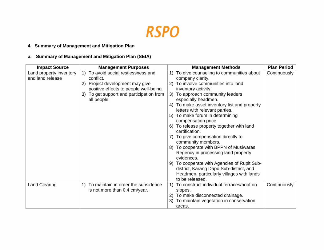
4. Summary of Management and Mitigation Plan
a. Summary of Management and Mitigation Plan (SEIA)
Impact Source Management Purposes Management Methods Plan PeriodLand property inventoryand land release
1) To avoid social restlessness andconflict.
2) Project development may givepositive effects to people well-being.
3) To get support and participation fromall people.
1) To give counseling to communities aboutcompany clarity.
2) To involve communities into landinventory activity.
3) To approach community leadersespecially headmen.
4) To make asset inventory list and propertyletters with relevant parties.
5) To make forum in determiningcompensation price.
6) To release property together with landcertification.
7) To give compensation directly tocommunity members.
8) To cooperate with BPPN of MusiwarasRegency in processing land propertyevidences.
9) To cooperate with Agencies of Rupit Sub-district, Karang Dapo Sub-district, andHeadmen, particularly villages with landsto be released.
Continuously
Land Clearing 1) To maintain in order the subsidenceis not more than 0.4 cm/year.
1) To construct individual terraces/hoof onslopes.
2) To make disconnected drainage.3) To maintain vegetation in conservation
areas.
Continuously

2) In order the land clearing will notresult in negative impact on flora andfauna around project location, so thepreservation kept maintained.
4) To cooperate with Farming Agency ofMusiwaras Regency in planning andimplementing land clearing activity.
5) To cooperate with Agency of Forestry inMusiwaras Regency in maintaining treesthat function as buffers.
1) To keep natural vegetation on 25 metresfrom right and left sides of rivers.
2) To plant woody vegetation onconservation lands.
3) To give education to communities andemployees not to hunt.
Employment Receipt 1) Employment receipt should followregulation.
2) Local manpower should be involvedin projects.
3) Plantation construction shouldcontribute positively to communitywell-being.
1) To improve kinship.2) To avoid the emergence of social
conflict and restlessness.
1) To disseminate job information publicly.2) To objectively filter manpower.3) To involve formal community leader.4) To follow prevailing regulations.5) To involve local entrepreneurs.6) To cooperate with Disnakertrans of
Musirawas Regency, agencies of sub-districts, and villages in receivingmanpower.
1) To respect prevailing norms and customsin villages around the project location.
2) To make hospitality forum to getrelationship closer.
3) To cooperate with Employment Agency ofMusirawas Regency in processingemployment receipt.
4) To respond all complaints from
Continuously

community wisely and well.5) To give assistance in constructing public
facilities and infrastructures.Farm maintenance andresult processing
1) To lower negative impacts of activityon decreased water quality aroundthe location.
2) Farm maintenance and resultprocessing do not give negativeimpact on drainage biota aspectaround the location.
1) To overcome pest and diseases throughthe concept of Integrated Pest Controlling.
2) To Construct Waste ProcessingInstallation with Anaerob/ FacultativePonding System.
1) To lower a number of chemical usage inmaintenance.
2) To arrange water channels continuouslyand conducively designed for drainagebiota.
3) To manage liquid waste optimally so theeffluent produced will not decrease theexisting water quality.
Continuously
Dryness frequently inevery dry season,community’s farms, anddefault factor fromemployees or certainpeople in field maycause fire in farms
To avoid fire. 1) To make monitoring towers equipped withtelescopes and communication tools.
2) To make retention pools and dam checks.3) To install warning signs.4) To give counseling to communities so
they do not clear lands by means of fire.5) To cooperate with Fire Brigade Agency of
Musirawas Regency to form and train acompany’s fire brigade unit.
Continuously
b. Summary of Management and Mitigation Plan (HCV)
No. HCVA Threat Management Recommendation MonitoringRecommendation
Plan Period

1 RiverBorder
1) The community andworkers (employees) donot fully understand theimportance of HighConservation Value / HCVfor sustainable farmmanagement andenvironmentalsustainability.
2) The possibility ofdifferences ininterpretation of theboundary area identifiedas HCV. If there are noclear boundaries, this canlead to land clearing inareas that have HCV,because contractors areoften more oriented to thetarget size of the volume ofwork. For example, theopening made in the areaaround the river banks.
3) Event logging of trees andencroachment on areascontaining HCV.
4) Activities involving the useof farm chemicals, both
General1) Socialization the identification
of high conservation valueareas to all parts concerned,ranging from the central levelto the managers in the field, soas to have same policy andunderstanding in themanagement of highconservation value.
2) There needs to be educationand outreach to thesurrounding community,employees, casual workersand contractors about theimportance of the functionareas of high conservationvalue that gives environmentalservices.
3) Arrangement and markingboundaries identified as HCV,which is followed by theinstallation of informationboards HCV location,mounting signs banning andappeal, especially fireprevention and cultivation andharvesting of trees that alreadyexist in the area who have
1) Monitoring the intensity ofdisturbance(encroachment, logging,fire).
2) Monitoring of riverdischarge and waterquality on a regular basiswith a certain period.
3) Monitoring rehabilitationsuccess rate.
4) Monitoring the level ofsedimentation in the river.
5) Monitor the presence ofsigns limits andinformation boards aboutthe location of the HCV 5order condition remainsgood.
6) Need to monitor theeffectiveness of thesanctions that areapplied, as well as.
7) Make regular reports 3months once the resultsof monitoring conducted.
2014
2014
2014-2016

fertilizers and pesticides inthe vicinity of the HCV 5can damage water qualityand the impact on peoplewho use the water.
HCV.
4) The protections of the areawith patrols were carried outon a regular basis. With thisevent , the efforts that couldcause disturbance to areas ofhigh conservation value can beanticipated since Early.
5) Control the use of syntheticchemicals (fertilizers andpesticides), especially in theblocks adjacent to the plantbodies of water such as ariver, so as not to cause adecline in water quality. Thedecline in water quality canlead to impacts on humans,given that most people still usewater from the river forsanitation purposes. Inaddition, it can also causedisruption to the presence ofwater and animal biodiversitycan also degrade the quality ofthe source water animals.
6) Cooperating with relevantparties in the management andmonitoring of HCV, eg
2014-continuously
2014-continuously
2014

community leaders, localgovernments, NGOs,universities, BP DAS.
7) To facilitate the managementarea containing HCV, will needto establish standardprocedures that poured intothe HCV Management SOP.
Border River
1) Establishment of border width50 m for rivers in the area of oilpalm plantation PT DEMIL. Forthe area of the river thatborders the road or otherfacility, then the width of borderadapted to existing conditions.
2) Inventory land cover conditionsby categorizing vacant area,shrubs, low density, highdensity, palm groves.Categorization is meant to beable to know that managementactions performed such asrehabilitation, enrichmentplanting.
3) Rehabilitation of river border
2014
2014
2014
2014-2015

with thehole system for anexisting plant area, preferablyusing the kinds of native plantsand can be combined withother types that have beenadapted and are not invasive.Selected types of plants are atype of plant that can providethe functions of biodiversityand soil and waterconservation with the stratifiedcanopy.
4) To control the pollution offertilizers and other chemicalsinto water bodies, then toareas located in the blocksnear the river do not do thecleaning cover crop (covercrops) for the blocks that are inthe river bank.
5) To grooves or trenches thatare notset the border, themanagement activities withattention to things like thefollowing: (a) needs to bemade levees; (b) controllingthe use of synthetic chemicals(fertilizers and pesticides) inorder not to get into the flow of
2014-2015
2014-2015

2 ForestedAreas
1) Encroachment /occupational.
2) Conversion of land due tounresolved compensationprocess by managers.
3) Fire land, given in the UParea gardens are found inpeople who often set fires toclear land.
4) Logging and poaching.
the water: (c) do not do thecleaning cover crop for areasadjacent to waterways /ditches; (d) planting a covercrop for the area adjacent.
1) Land acquisition of all forms ofownership of land stillcontrolled by third parties. Thisactivity is very important thatprotected areas have not yetreleased a clear legal status sothat management activities canbe carried out in accordancewith the functions andobjectives can be achievedwith either.
2) In order HCVA get a clear legalstatus by the UP and otherrelevant parties then HCVAshould be established togetherwith the related parties.Inaugural activities such as :a) Determination HCVA 1.1.b) Socialization layout,
functions and activitieswithin HCVA to all parties,including the public,regional government ormanagement staff.
1) Inventory of flora andfauna in the permanentsample plots wereconducted periodically(at least six months ofthe time) which can bedone by UPtogether/coordinationwith relevant partiessuch as the ForestService, BKSDA,Environmental ControlAgency, College /University and / orNGOs.
2) Registration of a crimerelated to the use offlora / fauna in the wild,especially in the use ofHCVA 1.1.
3) Registration offlammability level,especially around HCVA
2014-2016
20142014-2015

c) Installation of informationboards and signs HCVA,especially in the areaaround the town / villageand roads traversed by thepublic and staffmanagement unit .
d) The arrangement andmeasurement limits areparticipatory by involvinglocal government officials,community leaders, andcommunity representatives.
e) Piling limits, either in theform of boundary markersand poletan in the stem ofthe plant.
f) Endorsement documentboundary protected area isknown by the parties.
3) Preparation of Plan DocumentManagement and MonitoringHCVA integrated with theGeneral Management PlanGardens in the long run.
4) Preparation of documentsimportant habitat managementin the long term, medium andshort. This activity begins with
1.1.
4) Recording the location,extent, and model ofrehabilitation /enrichment HCVA typein 1.1. Accordance withthe Work PlanManagement andMonitoring HCVA 1.1.
5) Record the type andpercentage of plantspecies growing thatplant in HCVA 1.1.according with thedirectives of WorkManagement andMonitoring Plan HCVA1.1.
6) Monitoring the level ofsuccess of outreachprograms /environmentaleducation indicated thelevel of communityparticipation in helpingto secure the area and /or actively maintainHCVA 1.1.
2014
2014
2014-2016
2015
2014
2014

the preparation of the data /information base (baselineinformation) obtained frompopulation surveys and habitatwith a high sampling intensity(10 % -100 %).
5) Security HCVA canbeintegrated with the security ofthe UP. This activity is veryimportant for the safetypreservation HCVA potentialand / or management activitiesHCVA achieved in accordancewith the function and purpose.
6) Rehabilitation and / orenrichment type (enrichmentplanting) and / or conversion ofplant rubber trees to localendemic species in protectedareas that have been degradedor converted into rubberplantations. The main activitiescarried out along the river bankwhen this condition has beenrelatively open and fragmentedthat it cannot function as aborder and / or wildlife corridorwhich is very important insupporting the food chain and
7) Inventory of wildlifepopulations include: a)density, b) distributionand home range /territory, c) the agestructure, and d) the sexratio (especiallymammals andprimates). Inventory isdone in permanentsample plots wereconducted eachsemester (six monthsone time), especially thepopulation ofendangered / protected.
8) Inventory Habitat wildlifeinclude:
a) Abundance andavailabilityfeed wildlifeendangered /protected;
b) The availability andquality of waterresources;
c) Percentage of habitatfragmentation;
d) Level of human
2014
2017

energy balance.
7) Control fires / forest integratedwith the MU safety. Controlactivities can be carried out bythe controlled combustion ofsociety so it does not get intothe area, preparation ofinfrastructure and adequatefirefighting training firefightingpersonnel, improvement of earlywarning systems (earlywarningsystems) and periodictraining toall staff in fire control.
8) Socialization / outreach /environmental education to thestakeholders, especially localcommunities must continue tobe done regularly and in itsimplementation may coordinatewith relevant agencies.
9) Preparation of StandardOperating Procedure (SOP)SOP as Plant Inventory,Inventory wildlife, Rehabilitation/ Enrichment Type, PlantUtilization / wildlife by theparties, HCVA Security, FireControl, socialization HCVA
activity; ande) Inventory of rare
wildlife habitat /protected conductedeach semester (sixmonths one time).
9) Monitoring thepercentage ofsuccessfulmanagement of rareflora / protected.
10)Monitoring the intensityof disturbance thatincludes the logging ofrare flora / protectedand hunting /harvesting of wildlife,and destruction /removal of habitat thatis directly or indirectlya potential negativeimpact on the growthof animal population.
2014-2015
2014
2014

important to the parties.important to the parties.important to the parties.

5. Internal Responsibility
This Summary of Planning and Management has been approved by themanagement of PT Dendymarker Indahlestari.
Beni HendrawanChief Executive Officer
5. Internal Responsibility
This Summary of Planning and Management has been approved by themanagement of PT Dendymarker Indahlestari.
Beni HendrawanChief Executive Officer
5. Internal Responsibility
This Summary of Planning and Management has been approved by themanagement of PT Dendymarker Indahlestari.
Beni HendrawanChief Executive Officer


![#¾L 4õ Û4õ,º4w*F > DMIL · 2019. 9. 29. · xg5 4õ Á Ûf Û #¾l 4õ Û4õ,º4w*f > dmil Á j >,º Á Û Ýf Û 3 Á Û5 ºfpeýgý+^5 5n ' Ô)æq %m ] = ]+k#w ´3a µ 4õ](https://img.dokumen.tips/doc/110x75/60bdf22bc5c2f248e7132127/l-4-44wf-2019-9-29-xg5-4-f-l-4-44wf.jpg)