Embed Size (px)
Citation preview

Quaternary Research 72 (2009) 1–15
Contents lists available at ScienceDirect
Quaternary Research
j ourna l homepage: www.e lsev ie r.com/ locate /yqres
Stratigraphy, depositional environments and level reconstruction of the lastinterglacial Lake Samra in the Dead Sea basin
N. Waldmann a,⁎, M. Stein b, D. Ariztegui c, A. Starinsky a
a The Institute of Earth Sciences, The Hebrew University of Jerusalem, Givat Ram, 91904-Jerusalem, Israelb The Geological Survey of Israel, 30 Malkhei Yisrael St., 95501-Jerusalem, Israelc Earth Sciences Section, University of Geneva, Rue des Maraichers 13, 1205-Geneva, Switzerland
⁎ Corresponding author. Department of Earth Science,41, 5007-Bergen, Norway.
E-mail address: [email protected] (N. W
0033-5894/$ – see front matter © 2009 University of Wdoi:10.1016/j.yqres.2009.03.005
a b s t r a c t
a r t i c l e i n f oArticle history:Received 28 August 2007Available online 21 May 2009
Keywords:Last interglacialDead Sea basinLacustrine depositional environmentsPaleoclimatePaleolimnologySequence stratigraphyLake levelSedimentary basins
In this paper we describe the stratigraphy and sediments deposited in Lake Samra that occupied the Dead Seabasin between ∼135 and 75 ka. This information is combined with U/Th dating of primary aragonites inorder to estimate a relative lake-level curve that serves as a regional paleohydrological monitor. The lakestood at an elevation of ∼340 m below mean sea level (MSL) during most of the last interglacial. This level isrelatively higher than the average Holocene Dead Sea (∼400±30 m below MSL). At ∼120 and ∼85 ka, LakeSamra rose to ∼320 m below MSL while it dropped to levels lower than ∼380 m below MSL at ∼135 and∼75 ka, reflecting arid conditions in the drainage area. Lowstands are correlated with warm intervals in theNorthern Hemisphere, while minor lake rises are probably related to cold episodes during MIS 5b and MIS5d. Similar climate relationships are documented for the last glacial highstand Lake Lisan and the lowstandHolocene Dead Sea. Yet, the dominance of detrital calcites and precipitation of travertines in the Dead Seabasin during the last interglacial interval suggest intense pluvial conditions and possible contribution ofsouthern sources of wetness to the region.
© 2009 University of Washington. Published by Elsevier Inc. All rights reserved.
Introduction
During the Quaternary several lakes have occupied the tectonicdepressions along the Dead Sea transform (DST): the mid- to latePleistocene Lake Amora, the last interglacial Lake Samra, the lastglacial Lake Lisan and the Holocene to modern Dead Sea (Neevand Emery, 1967; Stein, 2001; Bookman et al., 2006; Torfstein,2008). The limnological conditions of these lakes (e.g., levels,structure and chemistry) were largely affected by hydrologicalchanges in their watershed (Stein, 2001; Enzel et al., 2003). Theirsedimentary record, therefore, serves as regional paleoclimatolo-gical gauges that consistently recorded wet and dry episodes at alltemporal scales.
This study focuses on the sedimentological and limnologicalhistory of Lake Samra that occupied the Dead Sea basin (DSB)during the last interglacial. Well-exposed stratigraphic sections fromonshore to lake-margin and deeper lacustrine environments areavailable for reconstruction of the paleoenvironmental conditionsand stratigraphy architecture (following similar works such asManspeizer, 1985, and Bartov et al., 2007, among others). Theremarkable preservation of lacustrine and fluvial archives from the
University of Bergen, Allégaten
aldmann).
ashington. Published by Elsevier In
last interglacial Dead Sea area provides insights into the paleocli-matological conditions of this region, which are still mostlyunknown for this period of time. In this work we present the firstsystematic documentation of sedimentary sections of the SamraFormation (that was deposited from Lake Samra) and thereconstruction of its depositional environments. Combining thesedimentological and stratigraphic information with U-series datingof primary aragonites, we were able to estimate the lake-levelhistory for the time interval between ∼130 and 75 ka. Thereconstructed lake level is compared to other records in order tounderstand potential regional and global climatic forcing during thelast interglacial.
Regional geology and previous studies
The DSB is the deepest continental pull-apart basin formed alongthe DST (Garfunkel, 1981; Ben-Avraham, 1997). During the Miocene,the basin was filled by fluvio-lacustrine deposits of the HazevaFormation (Garfunkel, 1981). Later during the Pliocene, the Mediter-ranean Sea intruded the DSB forming the Sedom lagoon thatdeposited thick sequences of salts (Zak, 1967). After the disconnectionof the lagoon from the open sea, terminal lacustrine bodiessuccessively occupied the basin: the middle to late Pleistocene LakeAmora, the last interglacial Lake Samra (the subject of this paper), thelast glacial Lake Lisan, and the Holocene Dead Sea (e.g., Stein, 2001;Bookman et al., 2006) (Fig. 1).
c. All rights reserved.

Figure 1. General stratigraphic section of the Dead Sea Group (adapted from Zak, 1967).
2 N. Waldmann et al. / Quaternary Research 72 (2009) 1–15
Whereas the last glacial Lake Lisan and the Holocene Dead Seahave been widely studied during the past few decades, providingsignificant archives of paleoenvironmental changes (e.g., Neev andEmery, 1967; Begin et al., 1974; Katz et al., 1977; Stein et al., 1997;Enzel et al., 2006), little is known about their last interglacialpredecessor, Lake Samra. The sediments deposited from this lake andits surroundings (composing the Samra Formation) are exposedalong the DSB from the Iddan region in the south to the centralJordan Valley in the north (Fig. 2). The formation was first describedin the Jericho area north of the Dead Sea as fluvio-lacustrine deposits(Picard, 1943; Rot, 1969; Begin et al., 1974; Begin, 1975). Zak (1967)correlated these exposures with the upper part of the AmoraFormation, which were mapped around the Mt. Sedom salt diapir,south of the Dead Sea. Other sedimentary units from the DSB wereassociated with the Samra Formation (e.g., Bentor and Vroman,1960; Langozky, 1961; Sneh, 1982; Manspeizer, 1985; Kaufman et al.,1992; Weinberger et al., 2000); however, a complete sedimentarydescription of these deposits was lacking as well as their spatialcorrelation.
Environments of deposition
The sediments deposited in Lake Samra and its surroundings(the Samra Formation) represent several depositional environ-ments similar to those previously described in detail for LakeLisan and the Holocene Dead Sea (Machlus et al., 2000; Bartovet al., 2002; Bookman (Ken-Tor) et al., 2004 and referencestherein). The following sedimentary environments are discussedin this paper: 1) the onshore depositional environment, whichincludes alluvial and fluvial deposits; 2) the marginal lacustrine
environment, which consists of a relatively narrow zone atandvalong the shore; and 3) the offshore lacustrine environ-ment that includes deposits from different water depths. Spe-cific lithofacies were recognized in these depositional environ-ments based on systematic differences in grain size, sedimentarystructures and textures, amount of clastic material, and beddingcharacteristics.
Onshore environments include mainly stream fan deltas, andalluvial and fluvial plains. At the lake margins, breaking waves washaway finer sediments building beach ridges that consist of pebbles orcoarse sand (Bartov et al., 2007). In flat areas such as the southernextreme of the basin, however, oolites cover extensive areas (Sneh,1982), occasionally interfingering with travertines (Enmar, 1999;Waldmann 2002; Waldmann et al., 2007). As deposits are shiftedtoward deep water, the influence of waves on deposition is reducedand grain size diminishes. The sediments may exhibit ripple marks,flute structures and cross-bedding as a consequence of wave energyvariations. Clay- to silt-size laminated deposition takes place inthe lacustrine environment indicating periods of layered-lake con-figuration, similar to that in Lake Lisan (Stein et al., 1997). It shouldbe highlighted, however, that while primary aragonite (depositedfrom the lake water) is a major constituent of the Lisan Formation,it seldom appears in the offshore lacustrine sedimentary sequencesof the Samra Formation, which consists mainly of calcitic marls(Waldmann et al., 2007).
Sequence stratigraphy
The lithofacies associations described above, recognized in thedifferent stratigraphic successions, represent regressive and trans-
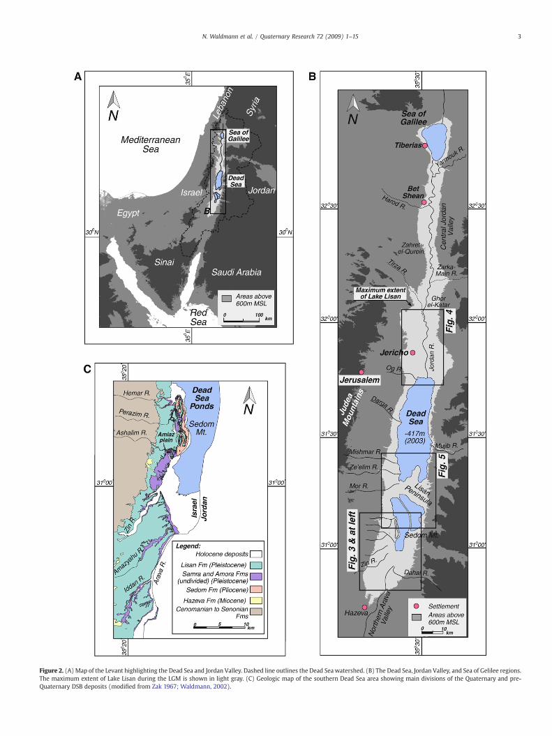
Figure 2. (A) Map of the Levant highlighting the Dead Sea and Jordan Valley. Dashed line outlines the Dead Seawatershed. (B) The Dead Sea, Jordan Valley, and Sea of Gelilee regions.The maximum extent of Lake Lisan during the LGM is shown in light gray. (C) Geologic map of the southern Dead Sea area showing main divisions of the Quaternary and pre-Quaternary DSB deposits (modified from Zak 1967; Waldmann, 2002).
3N. Waldmann et al. / Quaternary Research 72 (2009) 1–15
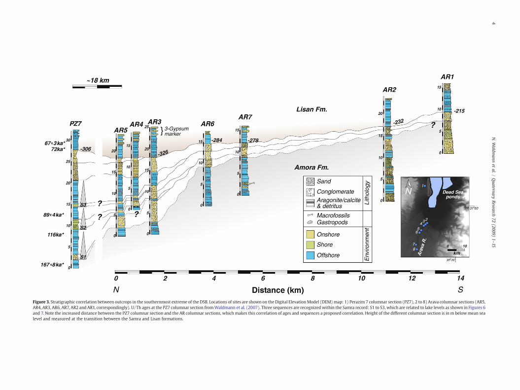
Figure 3. Stratigraphic correlation between outcrops in the southernmost extreme of the DSB. Locations of sites are shown on the Digital ElevationModel (DEM)map: 1) Perazim 7 columnar section (PZ7), 2 to 8) Arava columnar sections (AR5,AR4, AR3, AR6, AR7, AR2 and AR1, correspondingly). U/Th ages at the PZ7 columnar section fromWaldmann et al. (2007). Three sequences are recognized within the Samra record: S1 to S3, which are related to lake levels as shown in Figures 6and 7. Note the increased distance between the PZ7 columnar section and the AR columnar sections, which makes this correlation of ages and sequences a proposed correlation. Height of the different columnar section is in m belowmean sealevel and measured at the transition between the Samra and Lisan formations.
4N.W
aldmann
etal./
Quaternary
Research72
(2009)1–15

5N. Waldmann et al. / Quaternary Research 72 (2009) 1–15
gressive episodes of the lake. The sequence architecture ofthe Samra sediments is, therefore, attributed to three factors:lake-level fluctuations, initial topography/morphology and avail-ability of detrital material (following Posamentier et al., 1992). Inflat areas surrounding the basin, correlations among stratigraphicsections include intercalations of onshore and offshore depositsallowing reconstruction of the lake-level behavior. Taking intoconsideration the large size of the DSB and distances among thedifferent outcrops, we documented separately the stratigraphy ofthe Samra Formation in the southern, northern, and central parts ofthe basin.
The southern DSB
The stratigraphy of the southern extreme of the DSB is based onseven measured sections covering a distance of over 14 km along thewestern side of the Arava valley (Fig. 3). The correlation between theArava sections is based on marker beds that were physically traced inthe field and later compared to the same horizons dated in thePerazim 7 (PZ7) columnar section (Appendix A, on-line supplementalmaterial). We emphasize, however, that this correlation is onepossible interpretation under the existing limited age information.Distances between the columnar sections were measured using anelectronic distance measurement (EDM) and elevations confirmedwith differential GPS. The chronological framework is based on sev-eral U/Th ages (Waldmann et al., 2007) that were obtained fromaragonite laminae in the PZ7 columnar section and are summarizedin Table 1.
Five main sequences defined by major unconformities wereidentified in the exposures. The uppermost sequence stands for theLisan deposits, which was recognized by internal lithologicalmarkers such as thick packages of purely laminated aragonite anddetritus and defined gypsum beds (Bartov et al., 2002; Torfstein etal., 2008). The lowermost sequence is identified as part of the AmoraFormation based on the correlation of the sections in the northern-most Arava valley with the PZ7 columnar section. Both theselowermost and uppermost sequences were not considered in thestratigraphic analysis, while we focus here only on sequences S1 toS3 (Fig. 3).
The S1 sequence partially outcrops in the Arava valley in sectionsAR5, AR4 and AR3 consisting of pebble and cobble layers fining-upward to intercalations of silt and clay. Both the base and top of
Table 1U/Th ages of Samra and Lisan aragonites (modified from Waldmann et al., 2007).
Sample DSBlocation
Location Elevation Elevation Age Error Source
m MSL(a)
A/B transition(b)
ka (c)
PZ1-L6 South Perazim −305 1 67.4 3.4 1n.a. Perazim −322 −16 116 n.a. 2PZ2-7 Perazim −328 −22 167.2 8.4 1MZ-2 Central Massada −372 2 68.1 3.4 1MZ-5 Massada −375 −1 75.6 3.8 1MZ-7 Massada −380 −6 90.4 4.5 1MR-23 Mor −385 −1 71.5 3.6 1MR-6 Mor −386 −2 76.8 6.1 1MS-4 Mishmar −374.8 0.2 75.3 3.8 1MS-7 Mishmar −375 0.05 80.2 4.0 1MS-1 Mishmar −375 −0.1 87.1 4.4 1MS-10 Mishmar −375.5 −0.5 88.9 4.4 1BA-3 North Beit-Ha'Arava −364.8 0.2 71.6 3.0 1BA-5 Beit-Ha'Arava −365.6 −0.6 107.9 12.6 1
For site location see Figures 5, 6 and 7 (northern, southern and central sites,correspondingly). Comments: a) sample elevation in meters below mean sea level;b) sample elevation in relation to the stratigraphical transition between the Samraand Lisan formations; c) sources: 1: Waldmann et al. (2007); 2: Kaufman et al.(1992).
this unit are confined by erosional unconformities. The entiresequence thickens northwards with the increment of larger clastgrain sizes in those areas in relation to fluvial input. Thus, theelevation of the sequence represents the highest possible lake levelduring this period of deposition. An estimation of the S1 age isderived by correlation with the PZ7 columnar section (consideringpossible caveats due to the large distance), where an age ofapproximately 116 ka was obtained at ∼5 m above the sequence'sbase (Table 1).
Sequence S2 is exposed at the northernmost sections of the Aravavalley as well and is characterized by a fining-upward successionbounded by erosional surfaces. The sequence begins with coarse well-rounded clastic sediments overlain by intercalations of marls and finesilts, probably indicating a lake-level drop that was followed by aminor lake-level rise. As in S1, the age of S2 was estimated bycorrelation to PZ7, where a U/Th age of ∼89 ka was obtained from thelaminated section 4 m above the sequence base (Table 1). Identifyingnomajor unconformities and hiatuses within the lacustrine part of thesequence, we estimate that S2 was deposited between ∼115 and∼85 ka.
The overlying S3 sequence is similar to the previous sequencesconsisting of a fining-upward succession that starts with coarseand rounded clastic sediments overlain by intercalations of marlsand fine silts. It reaches a maximum thickness at the northern AR5columnar section while thinning and completely being erodedsouthwards. Overall, this sequence shows a transition from alluvialand fluvial deposits in the southernmost sites to a lake setting inthe north. Although there is no dated material in this sequence,we estimate its age by constraining the top of this cycle with aU/Th age obtained ∼1 m above the basis of the Lisan Formation inthe PZ7 columnar section. The retrieved U/Th age yielded ∼67 ka,thus placing this sequence between ∼85 and 75–70 ka. S3 isinterpreted as representing a short-term lake-level rise in thebasin.
The northern DSB
A stratigraphical correlation was physically traced in thenorthern DSB among four measured sections located along thewestern flanks of the Jordan River and following the basin axis(Fig. 4). Overall, the laminated lacustrine-type deposits thickensouthward as the clastic material increase northward, probablyrelated to increase clastic input by the Jordan and Tirza rivers(Fig. 2 for location). The stratigraphic boundary between theSamra and Lisan formations was identified by distinctive markerswithin the Lisan Formation (e.g., the triple gypsum unit; Bartovet al., 2002) and is chronologically constrained by U/Th agesretrieved at the Bet Ha'Arava columnar section (BA). At thislocality, an age of 72±3 ka was retrieved 20 cm above thistransition while an age of 108±12 ka was recovered ∼1 m belowit indicating a prominent depositional hiatus (Fig. 4, Table 1 andAppendix B, on-line supplemental material). North of the BetHa'Arava columnar section, the transition between the Samraand Lisan formations is characterized by a 1.5-m-thick paleosolhorizon enriched with gastropods, suggesting local increase inwetness.
The central DSB
Three columnar sections were erected in the central sector ofthe western Dead Sea margin: Massada (MZ), Mishmar (MS) andMor (MR) (Appendixes C, D and E, respectively in the on-linesupplemental material). The different sites are further correlated tothe previously described PZ7 columnar section (Fig. 5). Since nophysical continuation exists between these outcrops, the strati-graphic correlation was not performed in a typical “onshore to

Figure 4. Suggested stratigraphic correlation between outcrops in the northernmost part of the DSB. Locations of sites are shown on the DEMmap: DS: Deir Shaman, TV: Tovlan, AB:Allenby bridge and BA: Bet Ha'Arava. U/Th ages at the BA columnar section from Waldmann et al. (2007) and are resumed in Table 1. DS and AB columnar sections modified fromBegin et al. 1974. Heights of the different columnar sections are in m below mean sea level measured at the transition between the Samra and Lisan formations. See Figure 3 forlegend.
6 N. Waldmann et al. / Quaternary Research 72 (2009) 1–15
offshore” pattern (e.g., the proposed correlations in Figs. 3 and 4)but rather parallel to the lake's western shore. To minimizetruncation by streams entering the basin from the west, thedifferent sites were chosen in the terraces at the sides of present-day (and late Pleistocene) fan deltas, thus reducing possible tracesof erosion.
The three sites are mainly dominated by alternation of lami-nated lacustrine deposits, which are occasionally interrupted bysand and gavel layers interpreted as beach sediments. The in-formation gathered from the elevations and ages of those shoredeposits is crucial in reconstructing the lake-level variations.The stratigraphic boundaries between internal sub-units wereconstrained by several U/Th ages and recognition of distinctlithological markers (e.g., the triple gypsum unit; Bartov et al.,2002).
Chronology and level reconstruction of Lake Samra
The lake-level history proposed here (Fig. 6) is based on acombination of direct level indicators constrained chronologically inthe southern, northern and central regions, as described in theprevious section. The current effort to reconstruct the level curve forLake Samra follows similar studies by Bartov et al. (2002; 2007) onLake Lisan and Bookman (Ken-Tor) et al. (2004) and Bookman et al.(2006) on the Holocene Dead Sea. However, we are aware that inthe case of the Samra Formation that both the exposures and thesuitable material (primary aragonite) for U/Th age control arelimited. Nevertheless, the above described dataset allow for somesuggestions and several important conclusions regarding thepaleoenvironmental setting of the DSB during the last interglacialinterval. The dated samples considered for the lake-level recon-struction come from primary aragonite laminae that closely bound
shallow-water indicator sediments such as beach deposits. Inaddition, we assume a minimal deposition rate of about 1 mm/yrin the lacustrine deposits, which is slightly higher then the rateestimated for the laminated lacustrine sediments (primary aragoniteand silty detritus) comprising the Lisan Formation (ca. 0.8 mm/yr;Schramm et al., 2000). Low lake levels are estimated from thelowest elevation where the sequence boundary exhibits erosionalfeatures, while high levels are estimated from the highest elevationof lacustrine units in the sequence (Fig. 6). This techniqueoverestimates the absolute lake-level heights, providing a patternof regressions and transgressions and potential relative changes inlake level.
The transition between the Amora and Samra formations isdefined at the base of the S1 sequence (Fig. 6). This proposition isbased on a U/Th age of ∼167±4 ka measured on aragonite laminaapproximately one meter below the S1 sequence in the PZ7columnar section. Aragonite laminae of similar glacial MarineIsotope Stage (MIS) 6 ages compose the upper Amora Formationdescribed on the eastern side of Mt. Sedom (Torfstein, 2008).Considering the U/Th age of ∼116 ka retrieved from aragonitelaminae within the S1 sequence and the proposed sedimentationrate, we suggest that the transition between the Amora and Samraformations is located ∼130–140 ka, which is consistent with thetransition between MIS 6 and 5 in the global records. Taking intoconsideration a tectonic subsidence of 0.3 mm/yr for westernmargins of the DSB (Bartov et al., 2006), the onshore deposits thatdominate the lower part of the S1 sequence (Figs. 3, 4 and 5)were deposited during a lake stand lower than ∼380 m belowmean sea level (MSL) (Fig. 6). Following this lowstand, the lakelevel rose to elevations higher than ∼320 m below MSL at∼120 ka depositing relatively thick units of laminated lacustrinesediments (N5 m in the PZ7 columnar section; Appendix A in the

Figure 5. Proposed chronostratigraphic correlation between outcrops in the central part of the DSB compared to the PZ7 columnar section. Locations of sites are shown on the DEMmap: MS: Mishmar, MZ: Massada, MR: Mor and PZ7: Perazim 7. U/Th ages fromWaldmann (2002) and Waldmann et al. (2007) and are resumed in Table 1. Heights of the differentcolumnar sections are in m belowmean sea level measured at the transition between the Samra and Lisan formations. Note the enlarged distance between the central sites to the PZ7columnar section. See legend in Figure 3.
7N. Waldmann et al. / Quaternary Research 72 (2009) 1–15
on-line supplemental material). This elevation is estimated bycorrelating the exposures in the Arava valley (Fig. 3) and con-sidering a lower subsidence rate in that region (∼0.2 mm/yr)(Ben-Avraham and Schubert, 2006). Subsequently, the lake leveldropped again to ∼340–350 m below MSL at an estimated age of116 ka (as extrapolated from the chronology obtained in thecentral region and exposure of shore deposits in the southernregion; Figs. 5 and 3, respectively). During the S2 sequence thelake rose again above ∼310–320 m below MSL (Fig. 6), consi-dering elevations and ages of erosional surfaces recognized at theArava valley (Fig. 3). Approximately 90 ka, the lake receded againand fluctuated several times during sequence S3 before the riseof Lake Lisan at ∼75 ka to 260 m below MSL (Fig. 6) (Bartov et al.,2002; Waldmann et al., 2007). The upper boundary of the SamraFormation is placed at the sequence S3 termination (∼80–75 ka)marking the transition to the last glacial Lisan Formation (MIS 4 to2). Thus, the suggested chronology and distinctive lithologyidentifies the Samra Formation as an independent chronostrati-graphical unit composing sedimentary sequences that weredeposited during the last interglacial period.
In summary, the lithology and chronology of the describedexposures of the Samra Formation suggest that the lake fluctuatedmostly between ∼310 and ∼350 m below MSL. The estimated LakeSamra levels are ∼50–100 m higher than the mean level of theHolocene Dead Sea (Bookman (Ken-Tor) et al., 2004; Bookman et al.,2006; Migowski et al., 2006). This hydrological difference mayindicate a relative wetter regime during the last interglacial comparedto present conditions, or else changes in the tectonic subsidence rateof the basin.
Paleohydrological and paleoclimatic implications
The transition between lakes Samra and Lisanwas accompanied bya distinct lithological-geochemical change: Lake Samra depositedmainly detrital calcites and some primary calcite while Lake Lisanprecipitated mainly primary aragonite, silty detritus and gypsum.Waldmann et al. (2007) proposed that the limited amount ofaragonite precipitating during the Samra period reflects diminishingcontribution of the Dead Sea Ca-chloride brines to the lake. This, inturn was related to lower amounts of rain above the Judea Mountainsduring the last interglacial period. Moreover, the deposition oflaminated calcites in the Samra Formation indicates fresher waterconditions compared to Lake Lisan.
Lake Samra was fed by sporadic freshwater floods loaded withsubstantial amounts of detrital calcites; however, the transport ofbicarbonate required for aragonite production was limited(Waldmann et al., 2007). The paleohydrological and paleoclimaticimplications that are derived from the lithological assemblages ofboth the Samra and Lisan formations are corroborated by the lake-level patterns. Lake Lisan levels were substantially higher than thoseof Lake Samra (Fig. 7b). The differences in levels and lithology (Lisan:primary aragonite and gypsum; Samra: detrital calcites) indicate thatthe drainage area of the DSB was overall more arid during the lastinterglacial (Samra) interval than during the glacial (Lisan) period.Moreover, the last interglacial was characterized by sporadic floods,while the glacial interval was distinguished by regular supply ofwater.
Following paleoclimatic interpretations from the global sea-levelcurve deduced from coral records (Fig. 7e) (e.g., Stein et al., 1993;
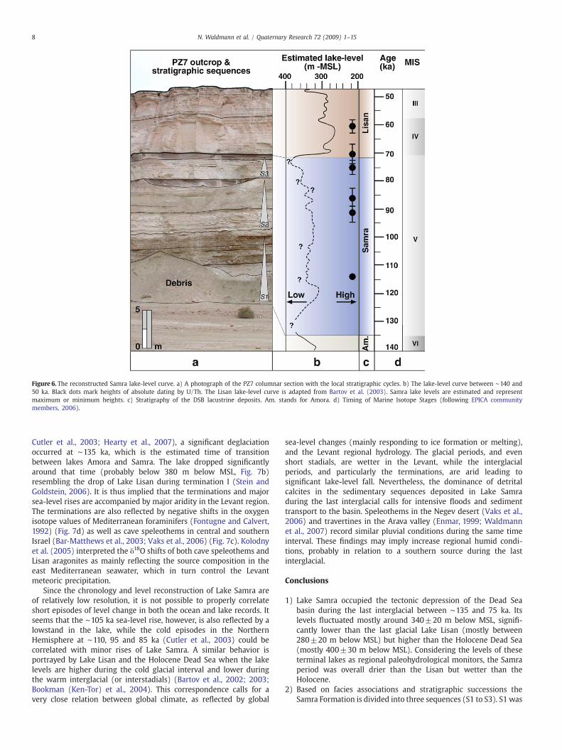
Figure 6. The reconstructed Samra lake-level curve. a) A photograph of the PZ7 columnar section with the local stratigraphic cycles. b) The lake-level curve between ∼140 and50 ka. Black dots mark heights of absolute dating by U/Th. The Lisan lake-level curve is adapted from Bartov et al. (2003). Samra lake levels are estimated and representmaximum or minimum heights. c) Stratigraphy of the DSB lacustrine deposits. Am. stands for Amora. d) Timing of Marine Isotope Stages (following EPICA communitymembers, 2006).
8 N. Waldmann et al. / Quaternary Research 72 (2009) 1–15
Cutler et al., 2003; Hearty et al., 2007), a significant deglaciationoccurred at ∼135 ka, which is the estimated time of transitionbetween lakes Amora and Samra. The lake dropped significantlyaround that time (probably below 380 m below MSL, Fig. 7b)resembling the drop of Lake Lisan during termination I (Stein andGoldstein, 2006). It is thus implied that the terminations and majorsea-level rises are accompanied by major aridity in the Levant region.The terminations are also reflected by negative shifts in the oxygenisotope values of Mediterranean foraminifers (Fontugne and Calvert,1992) (Fig. 7d) as well as cave speleothems in central and southernIsrael (Bar-Matthews et al., 2003; Vaks et al., 2006) (Fig. 7c). Kolodnyet al. (2005) interpreted the δ18O shifts of both cave speleothems andLisan aragonites as mainly reflecting the source composition in theeast Mediterranean seawater, which in turn control the Levantmeteoric precipitation.
Since the chronology and level reconstruction of Lake Samra areof relatively low resolution, it is not possible to properly correlateshort episodes of level change in both the ocean and lake records. Itseems that the ∼105 ka sea-level rise, however, is also reflected by alowstand in the lake, while the cold episodes in the NorthernHemisphere at ∼110, 95 and 85 ka (Cutler et al., 2003) could becorrelated with minor rises of Lake Samra. A similar behavior isportrayed by Lake Lisan and the Holocene Dead Sea when the lakelevels are higher during the cold glacial interval and lower duringthe warm interglacial (or interstadials) (Bartov et al., 2002; 2003;Bookman (Ken-Tor) et al., 2004). This correspondence calls for avery close relation between global climate, as reflected by global
sea-level changes (mainly responding to ice formation or melting),and the Levant regional hydrology. The glacial periods, and evenshort stadials, are wetter in the Levant, while the interglacialperiods, and particularly the terminations, are arid leading tosignificant lake-level fall. Nevertheless, the dominance of detritalcalcites in the sedimentary sequences deposited in Lake Samraduring the last interglacial calls for intensive floods and sedimenttransport to the basin. Speleothems in the Negev desert (Vaks et al.,2006) and travertines in the Arava valley (Enmar, 1999; Waldmannet al., 2007) record similar pluvial conditions during the same timeinterval. These findings may imply increase regional humid condi-tions, probably in relation to a southern source during the lastinterglacial.
Conclusions
1) Lake Samra occupied the tectonic depression of the Dead Seabasin during the last interglacial between ∼135 and 75 ka. Itslevels fluctuated mostly around 340±20 m below MSL, signifi-cantly lower than the last glacial Lake Lisan (mostly between280±20 m below MSL) but higher than the Holocene Dead Sea(mostly 400±30 m below MSL). Considering the levels of theseterminal lakes as regional paleohydrological monitors, the Samraperiod was overall drier than the Lisan but wetter than theHolocene.
2) Based on facies associations and stratigraphic successions theSamra Formation is divided into three sequences (S1 to S3). S1 was
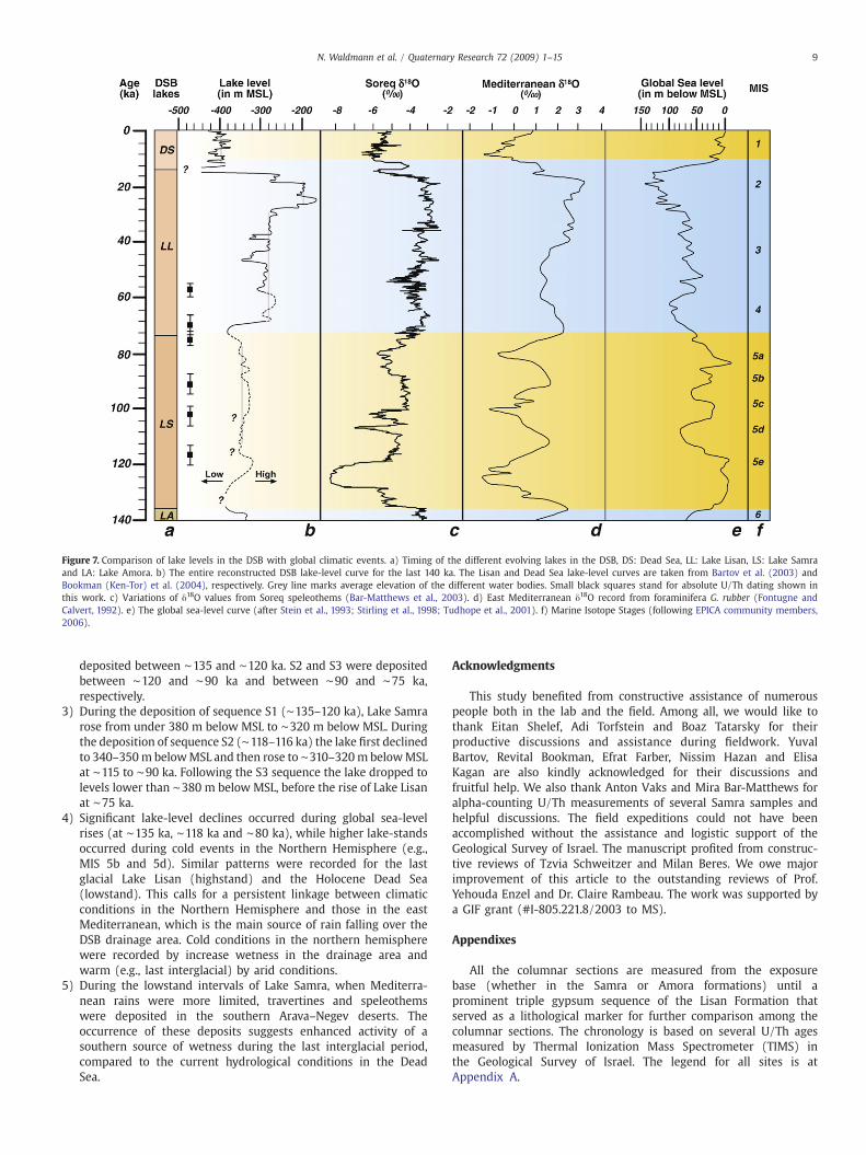
Figure 7. Comparison of lake levels in the DSB with global climatic events. a) Timing of the different evolving lakes in the DSB, DS: Dead Sea, LL: Lake Lisan, LS: Lake Samraand LA: Lake Amora. b) The entire reconstructed DSB lake-level curve for the last 140 ka. The Lisan and Dead Sea lake-level curves are taken from Bartov et al. (2003) andBookman (Ken-Tor) et al. (2004), respectively. Grey line marks average elevation of the different water bodies. Small black squares stand for absolute U/Th dating shown inthis work. c) Variations of δ18O values from Soreq speleothems (Bar-Matthews et al., 2003). d) East Mediterranean δ18O record from foraminifera G. rubber (Fontugne andCalvert, 1992). e) The global sea-level curve (after Stein et al., 1993; Stirling et al., 1998; Tudhope et al., 2001). f) Marine Isotope Stages (following EPICA community members,2006).
9N. Waldmann et al. / Quaternary Research 72 (2009) 1–15
deposited between ∼135 and ∼120 ka. S2 and S3 were depositedbetween ∼120 and ∼90 ka and between ∼90 and ∼75 ka,respectively.
3) During the deposition of sequence S1 (∼135–120 ka), Lake Samrarose from under 380 m below MSL to ∼320 m below MSL. Duringthe deposition of sequence S2 (∼118–116 ka) the lake first declinedto 340–350m belowMSL and then rose to ∼310–320m belowMSLat ∼115 to ∼90 ka. Following the S3 sequence the lake dropped tolevels lower than ∼380 m below MSL, before the rise of Lake Lisanat ∼75 ka.
4) Significant lake-level declines occurred during global sea-levelrises (at ∼135 ka, ∼118 ka and ∼80 ka), while higher lake-standsoccurred during cold events in the Northern Hemisphere (e.g.,MIS 5b and 5d). Similar patterns were recorded for the lastglacial Lake Lisan (highstand) and the Holocene Dead Sea(lowstand). This calls for a persistent linkage between climaticconditions in the Northern Hemisphere and those in the eastMediterranean, which is the main source of rain falling over theDSB drainage area. Cold conditions in the northern hemispherewere recorded by increase wetness in the drainage area andwarm (e.g., last interglacial) by arid conditions.
5) During the lowstand intervals of Lake Samra, when Mediterra-nean rains were more limited, travertines and speleothemswere deposited in the southern Arava–Negev deserts. Theoccurrence of these deposits suggests enhanced activity of asouthern source of wetness during the last interglacial period,compared to the current hydrological conditions in the DeadSea.
Acknowledgments
This study benefited from constructive assistance of numerouspeople both in the lab and the field. Among all, we would like tothank Eitan Shelef, Adi Torfstein and Boaz Tatarsky for theirproductive discussions and assistance during fieldwork. YuvalBartov, Revital Bookman, Efrat Farber, Nissim Hazan and ElisaKagan are also kindly acknowledged for their discussions andfruitful help. We also thank Anton Vaks and Mira Bar-Matthews foralpha-counting U/Th measurements of several Samra samples andhelpful discussions. The field expeditions could not have beenaccomplished without the assistance and logistic support of theGeological Survey of Israel. The manuscript profited from construc-tive reviews of Tzvia Schweitzer and Milan Beres. We owe majorimprovement of this article to the outstanding reviews of Prof.Yehouda Enzel and Dr. Claire Rambeau. The work was supported bya GIF grant (#I-805.221.8/2003 to MS).
Appendixes
All the columnar sections are measured from the exposurebase (whether in the Samra or Amora formations) until aprominent triple gypsum sequence of the Lisan Formation thatserved as a lithological marker for further comparison among thecolumnar sections. The chronology is based on several U/Th agesmeasured by Thermal Ionization Mass Spectrometer (TIMS) inthe Geological Survey of Israel. The legend for all sites is atAppendix A.

Appendix A. Detail description of the Perazim (PZ7) columnar section. The site is located at coordinates 18450/05580 on the base and 18517/05700 on the top of the columnarsection (New Israeli Grid projection).
10 N. Waldmann et al. / Quaternary Research 72 (2009) 1–15
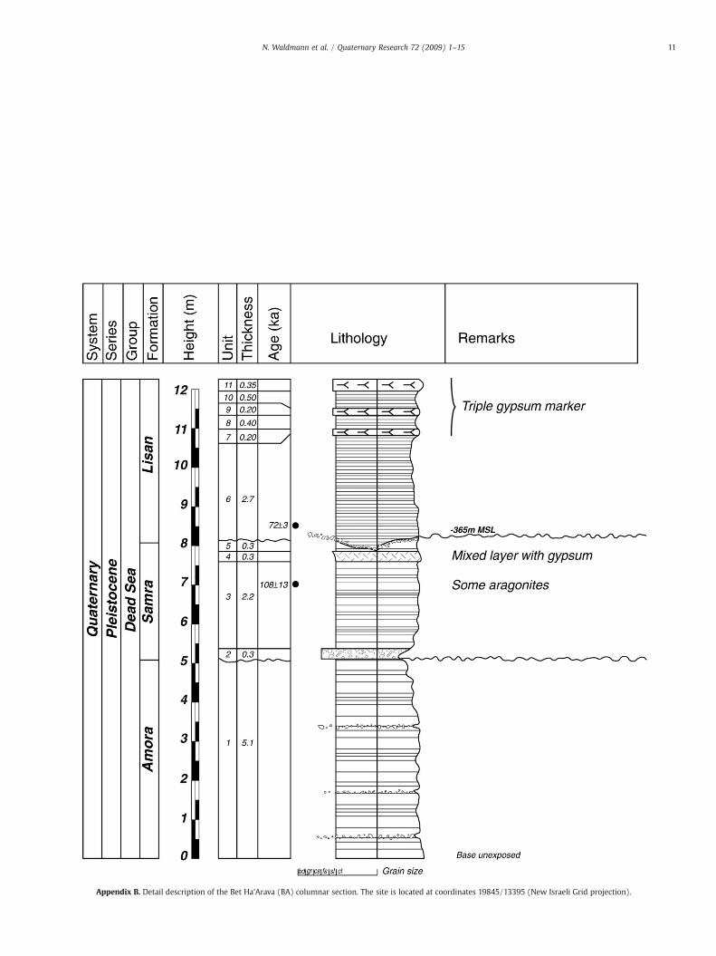
Appendix B. Detail description of the Bet Ha'Arava (BA) columnar section. The site is located at coordinates 19845/13395 (New Israeli Grid projection).
11N. Waldmann et al. / Quaternary Research 72 (2009) 1–15

Appendix C. Detail description of the Massada (MZ) columnar section. Coordinates: 18575/07955 (New Israeli Grid projection).
12 N. Waldmann et al. / Quaternary Research 72 (2009) 1–15

Appendix D. Detail description of the Mishmar (MS) columnar section. Coordinates: 18600/08615 (New Israeli Grid projection).
13N. Waldmann et al. / Quaternary Research 72 (2009) 1–15

Appendix E. Detail description of the Mor (MR) columnar section. Coordinates: 18570/17425 (New Israeli Grid projection).
14 N. Waldmann et al. / Quaternary Research 72 (2009) 1–15

15N. Waldmann et al. / Quaternary Research 72 (2009) 1–15
References
Bar-Matthews, M., Ayalon, A., Gilmour, M., Matthews, A., Hawkesworth, C.J., 2003.Sea-land oxygen isotopic relationships from planktonic foraminifera and spe-leothems in the EasternMediterranean region and their implication for paleorainfallduring interglacial intervals. Geochimica et Cosmochimica Acta 67, 3181–3199.
Bartov, Y., Stein, M., Enzel, Y., Agnon, A., Reches, Z., 2002. Lake levels and sequencestratigraphy of Lake Lisan, the Late Pleistocene precursor of the Dead Sea.Quaternary Research 57, 9–21.
Bartov, Y., Goldstein, S.L., Stein, M., Enzel, Y., 2003. Catastrophic arid episodes in theEastern Mediterranean linked with the North Atlantic Heinrich events. Geology 31(5), 439–442.
Bartov, Y., Agnon, A., Enzel, Y., Stein, M., 2006. Late Quaternary faulting and subsidencein the central Dead Sea basin. Israel Journal of Earth Sciences 55, 17–31.
Bartov, Y., Enzel, Y., Porat, N., Stein, M., 2007. Evolution of the Late Pleistocene–HoloceneDead Sea basin from sequence statigraphy of fan deltas and lake-level reconstruc-tion. Journal of Sedimentary Research 77, 680–692.
Begin, Z.B., 1975. Paleocurrents in the Plio-Pleistocene Samra Formation (Jericho region,Israel) and their tectonic implication. Sedimentary Geology 14, 191–218.
Begin, Z.B., Ehrlich, A., Nathan, Y., 1974. Lake Lisan the Pleistocene precursor of the DeadSea. Geological Survey of Israel Bulletin 63, 1–30.
Ben-Avraham, Z., 1997. Geophysical framework of the Dea Sea: structure and tectonics.In: Niemi, T.M., Ben-Avraham, Z., Gat, J.R. (Eds.), The Dead Sea, the Lake and itsSetting. Oxford University Press, New York, pp. 22–35.
Ben-Avraham, Z., Schubert, G., 2006. Deep “drop down” basin in the southern Dead Sea.Earth and Planetary Science Letters 251, 254–263.
Bentor, Y.K., Vroman, A., 1960. The geological map of Israel on a 1:100,000 scale; seriesA, The Negev, sheet 16, Mount Sdom, 2nd ed. .
Bookman (Ken-Tor), R., Enzel, Y., Agnon, A., Stein, M., 2004. Late Holocene lake levels ofthe Dead Sea. Geological Society of America Bulletin 116 (5/6), 555–571.
Bookman, R., Bartov, Y., Enzel, Y., Stein, M., 2006. Quaternary lake levels in the Dead Seabasin: two centuries of research. In: Enzel, Y., Agnon, A., Stein, M. (Eds.), NewFrontiers in Dead Sea Paleoenvironmental Research. Geological Society of AmericaSpecial Paper, 401, pp. 155–170.
Cutler, K.B., Edwards, R.L., Taylor, F.W., Cheng, J., Adkins, J., Gallup, C.D., Cutler, P.M., Burr,G.S., Bloom, A.L., 2003. Rapid sea-level fall and deep-ocean temperature changesince the last interglacial period. Earth and Planetary Science Letters 206, 253–271.
Enmar, L., 1999. The travertines in the Northern and Central Arava: stratigraphy,petrology and geochemistry. Geological Survey of Israel Report 1/99.
Enzel, Y., Bookman (Ken-Tor), R., Sharon, D., Gvirtzman, H., Dayan, U., Ziv, B., Stein, M.,2003. Late Holocene climates of the Near East deduced from Dead Sea levelvariations and modern regional winter rainfall. Quaternary Research 60, 263–273.
Enzel, Y., Agnon, A., Stein, M., 2006. New frontiers in Dead Sea paleoenvironmentalresearch. Geological Society of America Special Paper 401 253pp.
EPICA community members, 2006. One-to-one coupling of glacial climate variability inGreenland and Antarctica. Nature 444, 195–198.
Fontugne, M., Calvert, S.E., 1992. Late Pleistocene variability of the carbon isotopiccomposition of organic matter in the eastern Mediterranean: monitor of changes incarbon sources and atmosphere CO2 concentrations. Paleoceanography 7, 1–20.
Garfunkel, Z., 1981. Internal structure of the Dead Sea Leaky Transform (rift) in relationto plate kinematics. Tectonophysics 80, 81–108.
Hearty, P.J., Hollin, J.T., Neumann, A.C., O'Leary, M.J., McCulloc, M., 2007. Global sea-levelfluctuations during the Last Interglaciation (MIS 5e). Quaternary Science Reviews26, 2090–2112.
Katz, A., Kolodny, Y., Nissenbaum, A., 1977. The geochemical evolution of the PleistoceneLake Lisan — Dead Sea system. Geochimica et Cosmoquimica Acta 41, 1609–1629.
Kaufman, A., Yechieli, Y., Gardosh, M., 1992. Reevaluation of the Lake-sedimentchronology in the Dead Sea Basin, Israel, based on new 230Th/U dates. QuaternaryResearch 38, 292–304.
Kolodny, Y., Stein, M., Machlus, M., 2005. Sea-rain-lake relation in the Last Glacial EastMediterranean revealed by δ18O–δ13C in Lake Lisan aragonites. GeochimicaCosmochimica Acta 69, 4045–4060.
Langozky, Y., 1961. Remarks on the petrography and geochemistry of the Lisan MarlFormation. Unpublished MSc thesis, The Hebrew University, Jerusalem, Israel (inHebrew).
Machlus, M., Enzel, Y., Goldstein, S.L., Marco, S., Stein, M., 2000. Reconstruction lowlevels of Lake Lisan by correlating fan-delta and lacustrine deposits. QuaternaryInternational 73 (/74), 137–144.
Manspeizer, W., 1985. The Dead Sea rift: impact of climate and tectonism on Pleistoceneand Holocene sedimentation. In: Briddle-Kevin, T., Christie-Blick, N. (Eds.), StrikeSlip Deformation, Basin Formation and Sedimentation. Society of EconomicPaleontologists and Mineralogists Special Publication, 37, pp. 143–158.
Migowski, C., Stein, M., Prasad, S., Negendank, J.F.W., Agnon, A., 2006. Holocene climatevariability and cultural evolution in the Near East from the Dead Sea sedimentaryrecord. Quaternary Research 66, 421–431.
Neev, D., Emery, K.O., 1967. The Dead Sea, depositional processes and environments ofevaporites. Geological Survey of Israel Bulletin 41, 1–147.
Picard, L., 1943. Structure and evolution of Palestine (with comparative notes onneighboring countries). Geological Department Bulletin, The Hebrew University,Jerusalem 4, 34 pp.
Posamentier, H.W., Allen, G.P., James, D.P., Tesson, M., 1992. Forced regression in asequence stratigraphic framework: concepts, examples and exploration signifi-cance. Bulletin of American Association of Petroleum Geologists 76, 1687–1709.
Rot, I., 1969. The geology of Wadi-el-Qelt area. Unpublished MSc. thesis, The HebrewUniversity, Jerusalem, Israel (in Hebrew, English summary).
Schramm, A., Stein, M., Goldstein, S.L., 2000. Calibration of 14C time scale toN40 ka by234U–230Th dating of Lake Lisan sediments (last glacial Dead Sea). Earth andPlanetary Science Letters 175, 27–40.
Sneh, A., 1982. Quaternary of the Northwestern 'Arava. Israel. Israel Journal of EarthSciences 31, 9–16.
Stein, M., 2001. The sedimentary and geochemical record of Neogene-Quaternary waterbodies in the Dead Sea Basin — inferences for the regional paleoclimatic history.Journal of Paleolimnology 26, 274–282.
Stein, M., Goldstein, S.L., 2006. U-Th and radiocarbon chronologies of late Quaternarylacustrine records of the Dead Sea basin: methods and applications. In: Enzel, Y.,Agnon, A., Stein, M. (Eds.), New Frontiers in Dead Sea PaleoenvironmentalResearch. Geological Society of America Special Paper, 401, pp. 141–154.
Stein, M., Wasserburg, G.J., Aharon, P., Chen, J.H., Zhu, Z.R., Bloom, A., Chappell, J., 1993.TIMS U-series dating and stable isotopes of the last interglacial event in Papua NewGuinea. Geochimica et Cosmochimica Acta 57, 2541–2554.
Stein, M., Starinsky, A., Katz, A., Goldstein, S.L., Machlus, M., Schramm, A., 1997.Strontium isotopic, chemical, and sedimentological evidence for the evolution ofLake Lisan and the Dead Sea. Geochimica et Cosmoquimica Acta 61, 3975–3992.
Stirling, C.H., Esat, T.M., Lambeck, K., McCulloch, M.T., 1998. Timing and duration of theLast Interglacial: evidence for a restricted interval of widespread coral reef growth.Earth and Planetary Science Letters 160, 745–762.
Torfstein, A., 2008. Brine-freshwater interplay and effects on the evolution of salinelakes: the Dead Sea Rift terminal lakes. Geological Survey of Israel, ReportGSI/20/2008.
Torfstein, A., Gavrieli, I., Katz, A., Kolodny, Y., Stein, M., 2008. Gypsum as amonitor of thepaleo-limnological–hydrological conditions in Lake Lisan and the Dead Sea.Geochimica et Cosmochimica Acta 72, 2491–2509.
Tudhope, A.W., Chilcott, C.P., McCulloch, M.T., Cook, E.R., Chappell, J., Ellam, R.M., Lea, D.W., Lough, J.M., Shimmield, G.B., 2001. Variability in the El Niño-SouthernOscillation though a glacial–interglacial cycle. Science 291, 1511–1517.
Vaks, A., Bar-Matthews, M., Ayalon, A., Matthews, A., Frumkin, A., Dayan, U., Halicz, L.,Almogi-Labin, A., Schilman, B., 2006. Paleoclimate and location of the borderbetween Mediterranean climate region and the Saharo-Arabian Desert as revealedby speleothems from the northern Negev Desert. Israel. Earth Planetary ScienceLetters 249, 384–399.
Waldmann, N., 2002. The Geology of the Samra Formation in the Dead Sea Basin.Unpublished MSc thesis, The Hebrew University, Jerusalem, Israel (in English,Hebrew summary).
Waldmann, N., Starinsky, A., Stein, M., 2007. Primary carbonates and Ca-Chloride brinesas monitors of paleo-hydrological regime in the Dead Sea basin. Quaternary ScienceReviews 26, 2219–2228.
Weinberger, R., Yechieli, Y., Sneh, A., 2000. The Samra Formation in the Amiaz Plain:stratigraphic correlations of Pre-Lisan lake sediments in the Dead Sea rift.Geological Survey of Israel, Current Research 12, 231–234.
Zak, I., 1967. The geology of Mount Sedom. Unpublished PhD thesis, The HebrewUniversity, Jerusalem, Israel (in Hebrew, English summary).