Embed Size (px)
Citation preview
Spike is a smart laser measurement solution for all types of geospatial applications. With Spike, you can quickly measure the width, height and area of objects, such as buildings or other assets, simply by taking a photo from your smartphone or tablet. In addition, you can measure the distance between two points and quickly and safely capture a target’s location, your location, and a georeferenced image of the target. Data collected with Spike can be imported into GIS software including Collector for ArcGIS® and Survey123 for ArcGIS®. The Spike device and Spike mobile app transform your smartphone or tablet into a comprehensive geospatial measurement solution.
Spike: Photo-based Measurements For Geospatial Applications
BRINGING MEASUREMENTS WITHIN REACH
Collect data faster with Spike, reducing your field collection and measurement time to minutes. Faster data collection time leads to faster turnaround for reports and analyses. Photos and measurements are stored in either the mobile app or Spike Cloud, and can be organized into files or remeasured. No return trips are needed for additional measurements.
Save Time
With Spike, you can capture 5x more geospatial data than commercial smartphones and tablets. By capturing real-time measurements from a photo, including GPS location, distance, length and square footage, you can provide more accurate surveillance, inspection, reporting and analysis.
Improve Reporting
Cut your field data acquisition costs. Capture remote GPS location and measurements during field surveys without ladders, bucket trucks or expensive GPS equipment.
Cut Costs
Replace expensive and complicated GPS handheld devices with Spike and get more of your staff into the field. All it takes is one person to collect location and measurement data for a project, allowing you to grow your field data collection, inspection and reporting capacity. End user confidence is increased by using the photo documentation.
Increase Productivity
All of the data collected with Spike can be imported into Collector for ArcGIS and Survey123 for ArcGIS while in the field or back at the office. When cataloging a feature or an asset, you can include the Spike photo with measurements so the full history with photos is easily accessible.
Integrate with ArcGIS®
Capture measurements with Spike from a safe location and distance. There is no need to access the object in order to take measurements. Simply stand at a safe distance, aim the Spike laser at the object you wish to measure, and take a photo from your smartphone or tablet.
Safer Field Operations
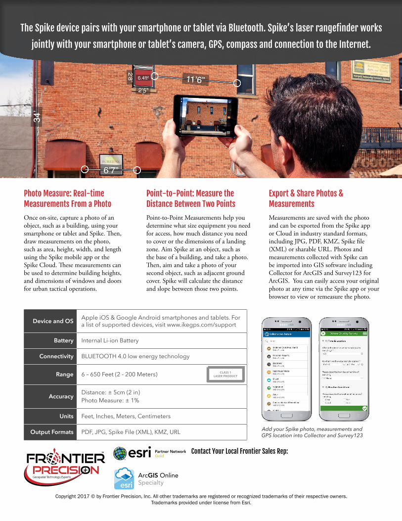
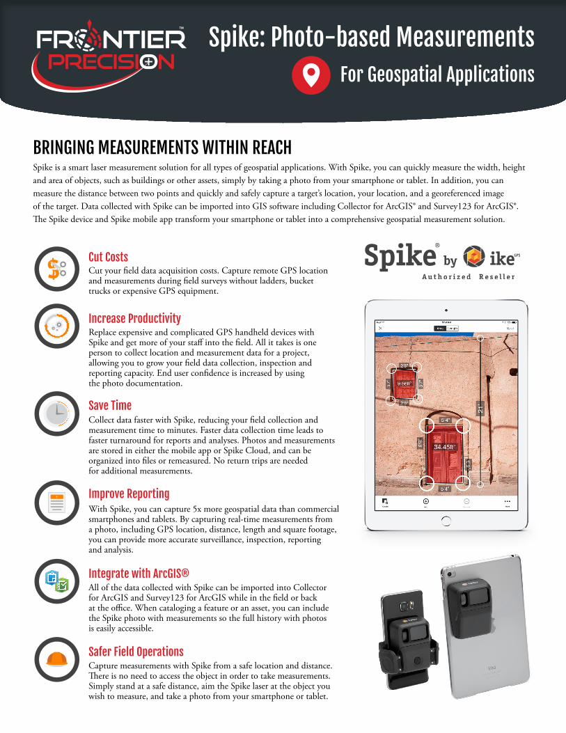
Once on-site, capture a photo of an object, such as a building, using your smartphone or tablet and Spike. Then, draw measurements on the photo, such as area, height, width, and length using the Spike mobile app or the Spike Cloud. These measurements can be used to determine building heights, and dimensions of windows and doors for urban tactical operations.
Point-to-Point Measurements help you determine what size equipment you need for access, how much distance you need to cover or the dimensions of a landing zone. Aim Spike at an object, such as the base of a building, and take a photo. Then, aim and take a photo of your second object, such as adjacent ground cover. Spike will calculate the distance and slope between those two points.
Measurements are saved with the photo and can be exported from the Spike app or Cloud in industry standard formats, including JPG, PDF, KMZ, Spike file (XML) or sharable URL. Photos and measurements collected with Spike can be imported into GIS software including Collector for ArcGIS and Survey123 for ArcGIS. You can easily access your original photo at any time via the Spike app or your browser to view or remeasure the photo.
Photo Measure: Real-time Measurements From a Photo
Point-to-Point: Measure the Distance Between Two Points
Export & Share Photos & Measurements
Device and OS Apple iOS & Google Android smartphones and tablets. For a list of supported devices, visit www.ikegps.com/support
Battery Internal Li-ion Battery
Connectivity BLUETOOTH 4.0 low energy technology
Range 6 – 650 Feet (2 - 200 Meters)
Accuracy Distance: ± 5cm (2 in)Photo Measure: ± 1%
Units Feet, Inches, Meters, Centimeters
Output Formats PDF, JPG, Spike File (XML), KMZ, URL
CLASS 1 LASER PRODUCT
The Spike device pairs with your smartphone or tablet via Bluetooth. Spike’s laser rangefinder works
jointly with your smartphone or tablet’s camera, GPS, compass and connection to the Internet.
Add your Spike photo, measurements and GPS location into Collector and Survey123
Copyright 2017 © by Frontier Precision, Inc. All other trademarks are registered or recognized trademarks of their respective owners. Trademarks provided under license from Esri.
Contact Your Local Frontier Sales Rep: