Embed Size (px)
Citation preview
Real Estate Sales • Auctions • Farm and Ranch Management • Appraisals • Insurance • Consultations Oil and Gas Management • Forest Resource Management • National Hunting Leases • FNC Ag Stock
www.FarmersNational.com
L-1900756
Serving America’s Landowners Since 1929
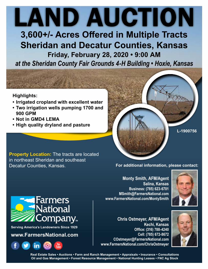
Highlights:• Irrigated cropland with excellent water• Two irrigation wells pumping 1700 and
900 GPM• Not in GMD4 LEMA• High quality dryland and pasture
Property Location: The tracts are located in northeast Sheridan and southeast Decatur Counties, Kansas. For additional information, please contact:
3,600+/- Acres Offered in Multiple TractsSheridan and Decatur Counties, Kansas
Friday, February 28, 2020 • 9:00 AMat the Sheridan County Fair Grounds 4-H Building • Hoxie, Kansas
Monty Smith, AFM/AgentSalina, Kansas
Business: (785) [email protected]
www.FarmersNational.com/MontySmith
LAND AUCTION
Chris Ostmeyer, AFM/AgentKechi, Kansas
Office: (316) 788-4240Cell: (785) 672-8672
[email protected]/ChrisOstmeyer

Property Description: Offering high quality farmland featuring 659+/- irrigated acres, 2,125+/- acres of dryland and 751+/- acres of native grass. Irrigated acres are not restricted by the GMD 4 LEMA.
Property Information
Tract 1 Legal Description: SW¼ Sec. 25-4-26, Decatur County, Kansas, consisting of 157 taxable acres.Farm Data:Dryland 156.8 acres (Currently all wheat.)FSA Information: Base Yield Corn 52.95 acres 118 bushelsWheat 39.58 acres 42 bushelsMilo 9.3 acres 73 bushelsSoybeans 7.18 acres 47 bushels2019 Taxes: $1,668.22Owned Minerals: 100%
Tract 2 Legal Description: SW¼ Sec. 35-4-26, Decatur County, Kansas, consisting of 156 taxable acres.Farm Data:Dryland 156.39 acres (Currently all wheat.)FSA Information: Base Yield Corn 52.82 acres 118 bushelsWheat 39.48 acres 42 bushelsMilo 9.28 acres 73 bushelsSoybeans 7.17 acres 47 bushels2019 Taxes: $1,788.06Owned Minerals: 100%
Tract 3 Legal Description: NW¼ Sec. 12-5-27 and SW¼ Sec. 1-5-27, Decatur County, Kansas, consisting of 316 taxable acres.Farm Data:Dryland 185.81 acresPasture 123.14 acresNon-crop 6.03 acresTotal 314.98 acresFSA Information: Base Yield Corn 61.65 acres 122 bushelsWheat 48.29 acres 40 bushelsMilo 5.31 acres 83 bushelsSoybeans 15.33 acres 57 bushels
Tract 3 (Continued)2019 Taxes: $2,078.72Owned Minerals: 100%
Tract 4 Legal Description: N½ Sec. 23-5-27, Decatur County, Kansas, consisting of 309 taxable acres.Farm Data:Dryland 209.37 acres Pasture 100.82 acresTotal 310.19 acres(Currently 35.98 acres in wheat.)FSA Information: Base Yield Corn 68.15 acres 122 bushelsWheat 53.38 acres 40 bushelsMilo 5.88 acres 83 bushelsSoybeans 16.95 acres 57 bushels2019 Taxes: $2,286.96Owned Minerals: 100%
Tract 5A Legal Description: SW¼ and the NW¼ exclud-ing pasture acres and dryland cropland in the E½ NW¼ Sec. 27-6-27; NE¼ Sec 28-6-27; NE¼ Sec 33-6-27, Sheridan County, Kansas.Farm Data: (acres are approximate)Dryland 122.88 acres Irrigated 412 acresNon-crop 1.27 acresTotal 536.15 acres (Currently 63.53 acres in wheat.)FSA Information: (See Tract 5)2019 Taxes: (Combined with 5B, contact Agent.)Owned Minerals: 100%
Tract 5B Legal Description: SE¼ and dryland cropland in the E½NW¼ and dryland cropland in the NE¼ Sec. 27-6-27; SW¼ Sec 26-6-27

Tract 5B (Continued)Farm Data: (acres are approximate)Dryland 156.92 acresIrrigated 247.37 acresNon-crop 1.88 acresTotal 406.17 acres(Currently 62.93 acres in wheat.)FSA Information: (See Tract 5)2019 Taxes: (Combined with 5A, contact Agent.)Owned Minerals: 100% except for SE¼ Sec. 27-6-27.
Tract 5 Legal Description: Combination 5A and 5B.Farm Data: (acres are approximate)Dryland 279.8 acres Irrigated 659.37 acresNon-crop 3.15 acresTotal 942.32 acres (Currently 126.46 acres in wheat.)FSA Information: Base Yield Corn 315.89 acres 122 bushelsWheat 247.44 acres 40 bushelsMilo 27.23 acres 83 bushelsSoybeans 78.55 acres 57 bushels(Tracts 5A, 5B and 7 are combined. If tracts are sold separately, FSA will split the base acres.)2019 Taxes: $20,157.96 (Includes pasture acres in N½ Sec. 27-6-27.)Owned Minerals: 100% except for SE¼ Sec. 27-6-27.
Tract 6 Legal Description: W½ Sec. 22-6-27 including pas-ture acres in N½ 27-6-27, Sheridan County, Kansas.Farm Data: (acres are approximate)Dryland 158.42 acresPasture 287.26 acresNon-crop 12.52 acresTotal 458.2 acresFSA Information: Base Yield Corn 50.68 acres 122 bushelsWheat 39.7 acres 40 bushelsMilo 4.37 acres 83 bushelsSoybeans 12.6 acres 57 bushels
Tract 6 (Continued)2019 Taxes: $1,152.44 (Excludes pasture acres in N½ Sec 27-6-27.)Owned Minerals: 100%(If Tract 5 and 6 are sold separately, there will be a 35' easement put in place due to an underground water line running thru the south end of the pasture in Section 27.)
Tract 7 Legal Description: SE¼ Sec. 21-6-27, Sheridan County, Kansas, consisting of 161 taxable acres.Farm Data:Dryland 33.97 acres (Currently all wheat.)Pasture 103.87 acresFeedlot/Bins 21.38 acresTotal 159.22 acresFSA Information: (Combined with NE¼ 28-6-27) (See Tract 5).2019 Taxes: $851.00Owned Minerals: 100%
Tract 8 Legal Description: SE¼ Sec. 22-6-26, Sheridan County, Kansas, consisting of 156.8 taxable acres.Farm Data:Dryland 138.14 acresNon-crop 18.03 acresTotal 156.17 acresFSA Information: Base Yield Corn 41.71 acres 143 bushelsWheat 56.73 acres 36 bushelsMilo 9.5 acres 46 bushels2019 Taxes: $1,209.62Owned Minerals: 50%
Tract 9 Legal Description: SE¼ Sec. 35-6-26, Sheridan County, Kansas, consisting of 158 taxable acres.Farm Data:Dryland 155.93 acres (Currently 74 acres in wheat.)FSA Information: Base Yield Corn 120.6 acres 143 bushels2019 Taxes: $1,506.82Owned Minerals: 33.33%

Tract 10 Legal Description: SE¼ Sec. 6-7-26, Sheridan County, Kansas, consisting of 156 taxable acres.Farm Data:Dryland 157.71 acresFSA Information: Base Yield Corn 63.9 acres 143 bushelsWheat 63.7 acres 38 bushels2019 Taxes: $1,296.84Owned Minerals: 100%
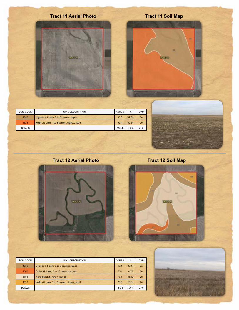
Tract 11 Legal Description: SE¼ Sec. 5-7-26, Sheridan County, Kansas, consisting of 156 taxable acres.Farm Data:Dryland 160.38 acres (Currently all wheat.)FSA Information: Base Yield Corn 54.17 acres 118 bushelsWheat 40.19 acres 42 bushelsMilo 9.51 acres 73 bushelsSoybeans 7.35 acres 47 bushels2019 Taxes: $1,331.12Owned Minerals: 100%
Tract 12 Legal Description: SW¼ Sec. 8-7-26, Sheridan County, Kansas, consisting of 159 taxable acres.Farm Data:Dryland 114.18 acresPasture 45.34 acresTotal 159.52 acresFSA Information: Base Yield Corn 32.5 acres 143 bushelsWheat 32.5 acres 37 bushels2019 Taxes: $1,373.40Owned Minerals: 100%
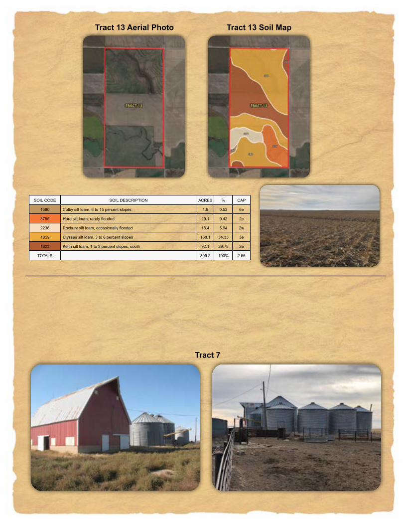
Tract 13 Legal Description: E½ Sec. 12-7-27, Sheridan County, Kansas, consisting of 306 taxable acres.Farm Data:Dryland 218.11 acresPasture 91.3 acresNon-Crop 1.93 acresTotal 311.34 acresFSA Information: Base Yield Corn 64.06 acres 143 bushelsWheat 87.12 acres 36 bushelsMilo 14.59 acres 46 bushels2019 Taxes: $1,866.38Owned Minerals: 100%
Irrigation Well Information: • Tract 5A: Water right #10181, 770 ac/ft. Test pumped 1,700 GPM• Tract 5B: Water right #13477, 530 ac/ft. Test pumped 900 GPM.Contact Agent for complete test pump results.
Irrigation Equipment: • Tract 5A • (NE¼ 33) 2012 7 Tower Valley Model 7000, SN 10885209, 1,298 Ft., 550 GPM w/agsense monitor (SW¼ 27) 1993 7 Tower Reinke 60 Lepa, SN/3939492, 1295 Ft., 500 GPM w/agsense montitor (NW¼ 27) 2012 Valley Model 7000, SN/10885205, 1,117 Ft., 300 GPM w/agsense monitor, half pivot(NE¼ 28) 1993 7 tower Reinke 60 Lepa, SN 3939493, 1295 Ft., 550 GPM, w/agsense monitor (W½ 27) West Well-6081 TF John Deere Diesel, 1810 hours, 200 HP Amarillo 1:1 Gearhead With Driveline and 10,000 gallon diesel tank w/fittings

Property Location Map����""-./01������2�� ��2���� ��2�� ��2�������2������2�2���
���� 2 �1�2��!�#� ��2�� �����21�����2$��2% �����2!�#2���������#��2 2%�2��&��%&��22'�()�*1 20��+����2#�,��2�2$����� ���2�2*����� ���2��2 2 1��#(&� �����2�2��������2 1���!�
Irrigation Equipment: (Continued)• Tract 5B • (SE¼ 27) 2012 7 Tower Valley Model 7000, SN/10885216, 1298 Ft., 550 GPM w/agsense monitor (SW¼ 26) – 1993 7 Tower Reinke 60 Lepa, SN/3939540, 1295 Ft., 550 GPM w/agsense monitor (W½ 27) East Well-6067 TA/MCL Case IH Diesel, 10800 Hours 200 HP Randolph 1:1 Gearhead with driveline 10,000 Gallon Diesel Tank w/fittings.

�,,,,,,��"'(,),)*+��,"'����,�� ����,���� ���� ���� � �� ��+� ��������,���(,��"��,�,(�,),���'� (,�������,��"� �," �,!��"#� )��+ $��* �'��+% ��������,���(,��"��,),(�,�,���'� (,�������,��"� �," �,!��"#� )%*�� &)�&* �������� )*+�� )��� ���
Tract 1 Soil MapTract 1 Aerial Photo
����""*+,-.�����/���� /����� /�����/��/���
�����/� ��./�������/����.�/�.�.�/���/ ���.�/���/����.��..�.�/�/ ./�.!�� !.�//#�$%�&��/'.�(��.�/��).�//�������.�/�/&�����..�/��/�/��.��$!.�..��/�/��������/��.�.��
����""*+,-.�����/���� /����� /�����/��/���
�����/� ��./�������/����.�/�.�.�/���/ ���.�/���/����.��..�.�/�/ ./�.!�� !.�//#�$%�&��/'.�(��.�/��).�//�������.�/�/&�����..�/��/�/��.��$!.�..��/�/��������/��.�.��
�......��")*.+.,-��+.")����.�� ����.���� ���� ���� � �� +�,� ���.���*.��"��.�.*�.�.���)��*.������ ,��� ��� ��+�� !��#��$�.���*.��"��.,.*�.�.���)��*.�������.��"���."�#.%��"&� , +�� ',�� +������� ,-��+ ,((� +�('
Tract 2 Soil MapTract 2 Aerial Photo
����""+,-./�����0���� 0����� 0�����0��0���
�����0� ��/0�������0����/�0�/�/�0 ��0!���/�0���0����/��//�/�0�0!/0�/#��!#/�00$�%&�'��0(/�)��/�0��*/�00 ������/�0�0'�����//�0��0�0��/��%#/�//��0�0��������0��/�/��
����""+,-./�����0���� 0����� 0�����0��0���
�����0� ��/0�������0����/�0�/�/�0 ��0!���/�0���0����/��//�/�0�0!/0�/#��!#/�00$�%&�'��0(/�)��/�0��*/�00 ������/�0�0'�����//�0��0�0��/��%#/�//��0�0��������0��/�/��

�......��")*.+.+,-��.")����.�� ����.���� ���� ���� � �� ���� ����.���*.��"��.-.*�.��.���)��*.������ ,���� +��+� -����� ���.���*.��"��.-.*�.,,.���)��*.�������.��� � !�+ ��+� #���,! ���.���*.��"��.+.*�.-.���)��*.������ !��� �#�!# +��-!# $�� ��%�.���*.��"��.,.*�.+.���)��*.�������.��"���."� .&��"'� ,���� #��-� �������� +,-�� ,��� +��(
Tract 3 Soil MapTract 3 Aerial Photo
����""+,-./�����0���� 0����� 0�����0��0���
�����0� ��/0�������0����/�0�/�/�0 ��0!���/�0���0����/��//�/�0�0!/0�/#��!#/�00$�%&�'��0(/�)��/�0��*/�00 ������/�0�0'�����//�0��0�0��/��%#/�//��0�0��������0��/�/��
����""+,-./�����0���� 0����� 0�����0��0���
�����0� ��/0�������0����/�0�/�/�0 ��0!���/�0���0����/��//�/�0�0!/0�/#��!#/�00$�%&�'��0(/�)��/�0��*/�00 ������/�0�0'�����//�0��0�0��/��%#/�//��0�0��������0��/�/��
�......��")*.+.,-���.")����.�� ����.�� ������ � �� � �����- ���.���*.��"��.�.*�.��.� �) !*.���� ��. ��# # ��$ ���+ + ��$+ %��#� & .���*.��"��.�.*�.,.� �) !*.���� ��.��"�!�."!#.'� "(� �+��� +���+ � ���$ ���.���*.��"��.,.*�.�.� �) !*.���� � ���+ ����� , ���� ���.���*.��"��.�.*�.�-.� �) !*.���� � $��� �,��� � ��$, %��#� & .���*.��"��.-.*�.�.� �) !*.���� ��.��"�!�."!#.'� "(� ,��$ ����� �)������ ,-��� �--� ,���
Tract 4 Soil MapTract 4 Aerial Photo
����""+,-./�����0���� 0����� 0�����0��0���
�����0� ��/0�������0����/�0�/�/�0 ��0!���/�0���0����/��//�/�0�0!/0�/#��!#/�00$�%&�'��0(/�)��/�0��*/�00 ������/�0�0'�����//�0��0�0��/��%#/�//��0�0��������0��/�/��
����""+,-./�����0���� 0����� 0�����0��0���
�����0� ��/0�������0����/�0�/�/�0 ��0!���/�0���0����/��//�/�0�0!/0�/#��!#/�00$�%&�'��0(/�)��/�0��*/�00 ������/�0�0'�����//�0��0�0��/��%#/�//��0�0��������0��/�/��

�......���.")�*+),-.�����.����. �� ��.��� �"�� � ��� � �"���� ��*--�-.-���.�)���.�.�).�. �!��,�.-�) �- ���� �#��� ������ $���%.-���.�)���.#.�).�. �!��,�.-�) �- �#�� ���� �����# )�&*.-���.�)���.�.�).��. �!��,�.-�) �- ���� ���� ������ $���%.-���.�)���.�.�).�. �!��,�.-�) �-�.-)'�% �(��� ����� ������� ����� �##� ����......�!���.��.��(�(.����. �� ��.��� �"�� � ��� � �"���� ��*--�-.-���.�)���.�.�).�. �!��,�.-�) �- ���� ����� ������ $���%.-���.�)���.#.�).�. �!��,�.-�) �- �#�� ���( �����# )�&*.-���.�)���.�.�).��. �!��,�.-�) �- ���� ���( ������ $���%.-���.�)���.�.�).�. �!��,�.-�) �-�.-)'�% ����� ����� ������� ��(�( �##� �����......�!���.��.�����.����. �� ��.��� �"�� � ��� � �"���� ��*--�-.-���.�)���.�.�).�. �!��,�.-�) �- ���� (��� ������ $���%.-���.�)���.�.�).�. �!��,�.-�) �-�.-)'�% ����� ����� ������� ����� �##� ��#(
Tract 5A Soil MapTract 5A Aerial Photo����"")*+,-������.�� ��.�������.�����.�.���
���� .�� �-�.������ ��.�� �����.-�����.���. �����.���.������������. . �.��!�� !��..#�$%�&- .,��'����.��(��.�.������ ���.�.&����� ���.��. . -���$!� �����.�.��������. -�����
����"")*+,-������.�� ��.�������.�����.�.���
���� .�� �-�.������ ��.�� �����.-�����.���. �����.���.������������. . �.��!�� !��..#�$%�&- .,��'����.��(��.�.������ ���.�.&����� ���.��. . -���$!� �����.�.��������. -�����

�......��")*.+,.-����.")���.�� ���.� �������� �� � � ����+� �������.���*.��"��.�.*�. .!��)�#*.���!�� +��� �-�� ���+�� ��$�.���*.��"��. .*�.�+.!��)�#*.���!�� ���% ��%� �� %� &��*'.���*.��"��.�.*�.�.!��)�#*.���!���.��(*' ����� �%��� %������ -���� ���� %�%�
Tract 5B Soil MapTract 5B Aerial Photo
����"",-./0������1�� ��1�������1�����1�1���
���� 1�� �0�1�� �!� ��1�� �����10�����1#��1$ �����1 �!1���������!��1 1$�1��%��$%��11&�'(�)0 1/��*����1!�+��1�1#����� ���1�1)����� ���1��1 1 0��!'%� �����1�1��������1 0��� �
����"",-./0������1�� ��1�������1�����1�1���
���� 1�� �0�1�� �!� ��1�� �����10�����1#��1$ �����1 �!1���������!��1 1$�1��%��$%��11&�'(�)0 1/��*����1!�+��1�1#����� ���1�1)����� ���1��1 1 0��!'%� �����1�1��������1 0��� �

�......���.")�*+),-.�����.��� .��� � .�����"��� ���� � ��"���� ��*--�-.-���.�)���.�.�).�.�� ��,�.-�)��- ����� ���!! ������ #���$.-���.�)���.%.�).�.�� ��,�.-�)��- �%�� ���� &����% �)�'*.-���.�)���.�.�).��.�� ��,�.-�)��- &!�� &��& ����&� #���$.-���.�)���.�.�).�.�� ��,�.-�)��-�.-)(�$ ��%�� ����� &���� ����� �%%� &�&��......� ���.�.�%���.��� .��� � .�����"��� ���� � ��"���� ��*--�-.-���.�)���.�.�).�.�� ��,�.-�)��- �%��! �&��� ������ #���$.-���.�)���.%.�).�.�� ��,�.-�)��- �%�� ���& &����% �)�'*.-���.�)���.�.�).��.�� ��,�.-�)��- &!�� ���� ����&� #���$.-���.�)���.�.�).�.�� ��,�.-�)��-�.-)(�$ ����% �&��� &���� �%��� �%%� &�&��......� ���.�.�����.��� .��� � .�����"��� ���� � ��"���� ��*--�-.-���.�)���.�.�).�.�� ��,�.-�)��- ���� !��& ����&� #���$.-���.�)���.�.�).�.�� ��,�.-�)��-�.-)(�$ ����� �&��� &���� ����� �%%� &�%!
Tract 5 Soil MapTract 5 Aerial Photo
����""+,-./������0�� ��0�������0�����0�0���
���� 0� �/�0���� � ��0�� �����0/�����0!��0# �����0�� 0��������� ��0 0#�0��$��#$��00%�&'�(/ 0.��)����0 �*��0�0!����� ���0�0(����� ���0��0 0 /�� &$� �����0�0��������0 /�����
����""+,-./������0�� ��0�������0�����0�0���
���� 0� �/�0���� � ��0�� �����0/�����0!��0# �����0�� 0��������� ��0 0#�0��$��#$��00%�&'�(/ 0.��)����0 �*��0�0!����� ���0�0(����� ���0��0 0 /�� &$� �����0�0��������0 /�����

�......���.")�*+),-.�����.����. �� ��.��� �"�� � ��� � �"���� ��*--�-.-���.�)���.�.�).�.�� ��,�.-�)��- ��!�� ����# �����! )�$*.-���.�)���.�.�).��.�� ��,�.-�)��- %�%�% ����� ����%� &���'.-���.�)���.�.�).�.�� ��,�.-�)��-�.-)(�' ���� ��!� %������ ����� �!!� ��#��......� ���.�.�##��.����. �� ��.��� �"�� � ��� � �"���� ��*--�-.-���.�)���.�.�).�.�� ��,�.-�)��- �%��� ����� �����! )�$*.-���.�)���.�.�).��.�� ��,�.-�)��- %%��� �!�#� ����%� &���'.-���.�)���.�.�).�.�� ��,�.-�)��-�.-)(�' ���� ��� %������ �##�� �!!� ��##�......� ���.�.���%.����. �� ��.��� �"�� � ��� � �"���� ��*--�-.-���.�)���.�.�).�.�� ��,�.-�)��- ���� �#�%% �����! )�$*.-���.�)���.�.�).��.�� ��,�.-�)��- �%�� �%�## ����%� &���'.-���.�)���.�.�).�.�� ��,�.-�)��-�.-)(�' !�! !�! %������ ���% �!!� ����
Tract 6 Soil MapTract 6 Aerial Photo����"")*+,-������.�� ��.�������.�����.�.���
���.�.����� ���� .� �-�.���� � ��.�� �����.-�����.!��.# �����.�� .��������� ��. .#�.�����#���..$�%��&- .,��'����. �(��.�.!����� ���.�.&����� ���.��. . -�� %�� �����.�.��������. -�����
����""+,-./������0�� ��0�������0������0�0���
���� 0� �/�0���� � ��0�� �����0/�����0!��0# �����0�� 0��������� ��0 0#�0��$��#$��00%�&'�(/ 0.��)����0 �*��0�0!����� ���0�0(����� ���0��0 0 /�� &$� �����0�0��������0 /�����

�------��"()-*-+,+��-"(����-�� ����-���� ���� ���� � �� +��� �������-���)-��"��-�-)�-,-���(��)-������ �*�� ����, ��+�� ���!�-���)-��"��-,-)�-+�-���(��)-������ �*�+ , � + ,�+,#� $��)%-���)-��"��-+-)�-�-���(��)-�������-��&)% *�# '�'� #������� +,+�� + � '�*,
Tract 7 Soil MapTract 7 Aerial Photo
����""*+,-.������/�� ��/�������/�����/�/���
���� /� �.�/������ ��/�� �����/.�����/ ��/! �����/���/������������/ /!�/��#��!#��//$�%&�'. /-��(����/��)��/�/ ����� ���/�/'����� ���/��/ / .���%#� �����/�/��������/ .�����
����""*+,-.������/�� ��/�������/�����/�/���
���� /� �.�/������ ��/�� �����/.�����/ ��/! �����/���/������������/ /!�/��#��!#��//$�%&�'. /-��(����/��)��/�/ ����� ���/�/'����� ���/��/ / .���%#� �����/�/��������/ .�����
Tract 8 Soil MapTract 8 Aerial Photo
����""+,-./������0�� ��0�������0�����0�0���
���� 0� �/�0���� � ��0�� �����0/�����0!��0# �����0�� 0��������� ��0 0#�0��$��#$��00%�&'�(/ 0.��)����0 �*��0�0!����� ���0�0(����� ���0��0 0 /�� &$� �����0�0��������0 /�����
����""+,-./������0�� ��0�������0�����0�0���
���� 0� �/�0���� � ��0�� �����0/�����0!��0# �����0�� 0��������� ��0 0#�0��$��#$��00%�&'�(/ 0.��)����0 �*��0�0!����� ���0�0(����� ���0��0 0 /�� &$� �����0�0��������0 /������------��"()-*-+,���-"(����-�� ����-�� ������ � �� � ��+*,� �������-���)-��"��-�-)�-�-���(��)-������ +�� *��, ��+,*! ��#�-���)-��"��-�-)�-+,-���(��)-������ ,�� +��$+ ��+� � %��)&-���)-��"��-+-)�-�-���(��)-�������-��')& ++*�* �,� � ������� +,��� +!!� ��$

�++++++��"&'+(+)*���+"&����+�� ����+�� ������ � �� � ��)�)( ���'�+���'+��"��+�+'�+)+���&��'+������ )�(�� (*��( &)!*( #�$����+���'+��"��+�+'�+�+���&��'+������ %�� ��* �������� )*��� )��� ���
Tract 9 Soil MapTract 9 Aerial Photo
����""+,-./������0�� ��0�������0�����0�0���
���� 0� �/�0���� � ��0�� �����0/�����0!��0# �����0�� 0��������� ��0 0#�0��$��#$��00%�&'�(/ 0.��)����0 �*��0�0!����� ���0�0(����� ���0��0 0 /�� &$� �����0�0��������0 /�����
����""+,-./������0�� ��0�������0�����0�0���
���� 0� �/�0���� � ��0�� �����0/�����0!��0# �����0�� 0��������� ��0 0#�0��$��#$��00%�&'�(/ 0.��)����0 �*��0�0!����� ���0�0(����� ���0��0 0 /�� &$� �����0�0��������0 /�����
Tract 10 Soil MapTract 10 Aerial Photo
����""+,-./������0�� ��0�������0�����0�0���
���� 0�� �/�0���� � ��0�� �����0/�����0!��0# �����0�� 0��������� ��0 0#�0��$��#$��00%�&'�(/ 0.��)����0 �*��0�0!����� ���0�0(����� ���0��0 0 /�� &$� �����0�0��������0 /�����
����""+,-./������0�� ��0�������0�����0�0���
���� 0�� �/�0���� � ��0�� �����0/�����0!��0# �����0�� 0��������� ��0 0#�0��$��#$��00%�&'�(/ 0.��)����0 �*��0�0!����� ���0�0(����� ���0��0 0 /�� &$� �����0�0��������0 /������------��"()-*+-*,���-"(����-�� ����-�� ������ � �� � ��*,�+ ����-���)-��"��-�-)�-*,-���(��)-������ ��* *��� ��*�, !������-���)-��"��-�-)�-�-���(��)-������ #$�$ $�� * ��*��� %��)&-���)-��"��-*-)�-�-���(��)-�������-��')& ���* ,*�#, �������� *,��� *++� ��,�
�,,,,,,��"'(,)),)*+��,"'����,�� ����,���� ���� ���� � �� )�*+ �������,���(,��"��,�,(�,�,���'��(,������ � � �!��* ��)�#� $��(%,���(,��"��,),(�,�,���'��(,�������,��&(% ++�� �#��� #������� )*+�� ) � #���
Tract 11 Soil MapTract 11 Aerial Photo
����""*+,-.������/�� ��/�������/�����/�/���
���� /�� �.�/������ ��/�� �����/.�����/ ��/! �����/���/������������/ /!�/��#��!#��//$�%&�'. /-��(����/��)��/�/ ����� ���/�/'����� ���/��/ / .���%#� �����/�/��������/ .�����
����""*+,-.������/�� ��/�������/�����/�/���
���� /�� �.�/������ ��/�� �����/.�����/ ��/! �����/���/������������/ /!�/��#��!#��//$�%&�'. /-��(����/��)��/�/ ����� ���/�/'����� ���/��/ / .���%#� �����/�/��������/ .�����
Tract 12 Soil MapTract 12 Aerial Photo
����""*+,-.������/�� ��/�������/�����/�/���
���� /�� �.�/������ ��/�� �����/.�����/ ��/! �����/���/������������/ /!�/��#��!#��//$�%&�'. /-��(����/��)��/�/ ����� ���/�/'����� ���/��/ / .���%#� �����/�/��������/ .�����
����""*+,-.������/�� ��/�������/�����/�/���
���� /�� �.�/������ ��/�� �����/.�����/ ��/! �����/���/������������/ /!�/��#��!#��//$�%&�'. /-��(����/��)��/�/ ����� ���/�/'����� ���/��/ / .���%#� �����/�/��������/ .������000000��"+,0-.0-/��/0"+����0�� ����0���� ���� ���� � �� -�/� �������0���,0��"��0�0,�0�0���+��,0������ ��- �!�-# ��-/�! ���$�0���,0��"��0�0,�0-/0���+��,0������ #�� �#� ���#// %��&0���,0��"��0�"����0'���&�& ##�# ��#. .+-�.� (��,)0���,0��"��0-0,�0�0���+��,0�������0��*,) .��! -���- .������� -/��/ -!!� .� �
�222222��"-.2/0201���2"-����2�� ����2�� ������ � �� � ��/��1 ����2���.2��"��2�2.�2/�2���-� .2������ /�� 1��� ��0!�� #��$2���.2��"��2�"����2%���$�$ ���/ ��&� �-��0� �'�(��2���.2��"��2�--"��� "���2%���$�$ /��& ���& �)/��� *������2���.2��"��202.�2�2���-� .2������ /���/ �&�0� 0�/��0 +��.,2���.2��"��2/2.�202���-� .2�������2��(., ���/ ���!� �������� 01��� /11� ����
Tract 13 Soil MapTract 13 Aerial Photo
����""+,-./������0�� ��0�������0�����0�0���
���� 0�� �/�0���� � ��0�� �����0/�����0!��0# �����0�� 0��������� ��0 0#�0��$��#$��00%�&'�(/ 0.��)����0 �*��0�0!����� ���0�0(����� ���0��0 0 /�� &$� �����0�0��������0 /�����
����""+,-./������0�� ��0�������0�����0�0���
���� 0�� �/�0���� � ��0�� �����0/�����0!��0# �����0�� 0��������� ��0 0#�0��$��#$��00%�&'�(/ 0.��)����0 �*��0�0!����� ���0�0(����� ���0��0 0 /�� &$� �����0�0��������0 /�����
Tract 7

Minerals: All mineral interests owned by the Seller, if any, will be conveyed to the Buyer(s).
Taxes: Seller will pay those real estate tax installments due and payable through 2019.
Conditions: This sale is subject to all easements, covenants, restrictions of record, and leases. Each Bidder is responsible for conducting, at their own risk, their own inspections, inquiries, and due diligence concerning the property. All property is sold on an “AS IS-WHERE IS” basis with no warranties or guarantees, either expressed or implied, by the Seller or Farmers National Company.
Possession: Possession will be granted at closing on April 1, 2020 or such other date agreed to by the parties. Subject to tenant’s rights on growing wheat acres. Buyer(s) to receive 1/3 share of growing wheat. Buyer(s) will reimburse Seller for expenses related to 2020 wheat crop inputs and burndown expenses on open ground, where applicable.
Earnest Payment: A 10% earnest money payment is required on the day of the bidding. The payment may be in the form of cashier’s check, personal check, company check, or wired funds. All funds will be deposited and held by the closing agent.
Contract and Title: Immediately upon conclusion of the bidding, the high bidder(s) will enter into a real estate contract and deposit with the closing agent the required earnest payment. The Seller will provide an owner’s policy of title insurance in the amount of the contract price. The cost of title insurance and any escrow closing services will be paid equally by both the Seller and Buyer(s). Sale is not contingent upon Buyer(s) financing.
Closing: The sale closing is on April 1, 2020 or such other date agreed to by the parties. The balance of the purchase price will be payable at closing in guaranteed funds or by wire transfer at the discretion of the closing agent.
Survey: At the Seller’s option, the Seller shall provide a property survey sufficient to provide good title where there is not an existing legal or where new boundaries are created. The Seller will pay the survey cost. Final contract prices will not be adjusted to reflect any difference between the advertised and actual surveyed acres.
Sale Method: The real estate will be offered in 15 individual tracts. Tracts 1-4,5A,5B and 5-13. Tract 5 is a combination of tracts 5A and 5B. All bids are open for advancement until the Auctioneer announces that the real estate is sold or that the bidding is closed. The real estate will sell in the manner resulting in the highest total price. Bidding increments are solely at the discretion of the Auctioneer. No absentee or telephone bids will be accepted without prior approval of Farmers National Company and Seller. All decisions of the Auctioneer are final.
Approval of Bids: Final sale is subject to the Seller’s approval or rejection.
Agency: Farmers National Company and its representatives are acting as Agents of the Seller.
Announcements: Information provided herein was obtained from sources deemed reliable, but neither Farmers National Company nor the Seller makes any guarantees or warranties as to its accuracy. All potential bidders are urged to inspect the property, its condition, and to rely on their own conclusions. All sketches, dimensions, and acreage figures are approximate or “more or less”. Any announcements made auction day by Farmers National Company will take precedence over any previous printed materials or oral statements. Farmers National Company and Seller reserve the right to preclude any person from bidding if there is any question as to the person’s credentials or fitness to bid.
Seller: Abercrombie Marital Trust
Auctioneer: Van Schmidt
AUCTION TERMS