Embed Size (px)
Citation preview

1

Roles of the Survey and Mapping Office (SMO) of Lands Department
establishment and maintenance of a geodetic network;
provision of land boundary (cadastral) surveys, photogrammetric survey as well as cartographic and reprographic services;
maintenance of a computerised land information system for mapping data and land boundary records;
production and revision of maps and plans at different scales for different purposes; and
administration of the Land Survey Ordinance (Cap. 473).
2

• For topographical map applications• For planning and works applications by architects,
engineers, planners, developers, etc.• For general and social applications• For GIS developments / applications
Applications:
2D Topographic Map
235 features in 1:1000 Basic Map3
Has been used for decades and it is a very effective
topographical map for various applications

2D map is insufficient
Conventional Map Our Real World
H
Change of Land Use
4

3D Spatial Data of LandsD
5
Started
in 2007
Launched
in 2012

3D Spatial Data of LandsD
6
~210,000 models (L1)
~9,000 models (L2&L3)
~2000 models
~90 major roads
Territory-wide
Building Height
(>10m)
~53000 models

3 Aspects of3D Mapping Development- Now and Future
7

3 Aspects of 3D Mapping Development - Now and Future
(1) 3D Data Capture / Data Collection
(2) 3D Data Standards and Modelling
(3) 3D Data Sharing
8

(1)3D Data Capture/
Data Collection
9

(1) 3D Data Capture / Data Collection
Laser Scanner
Unmanned Aerial Vehicle (UAV)Backpack Mobile Mapping System, MMS
Large Format Digital Camera
Vehicle Mobile Mapping System
20082013
2016
2017
10
Advanced survey technologies replace
conventional survey methods

11
Phase I• Fixed-wing Aircraft / Helicopter
• Captured at 6,000 and 7,000 Ft Altitude
• 10cm GSD
• 174 sq.km
Phase II• Helicopter
• Captured at 1,000 and 2,000 Ft Altitude
• 8cm GSD
• 165 sq.km
Outsourcing Mesh Model Projects
(1) 3D Data Capture / Data Collection

12
Project Areas Mesh Models
Photorealistic Mesh Model
(1) 3D Data Capture / Data Collection

Provision of 3D Textured Mesh Model
3D Textured Mesh Model Limitations of 3D Textured Mesh Model
To enrich the 3D Spatial Data of LandsD
13

(1) 3D Data Capture / Data CollectionImage and laser points captured by Vehicle-based
Mobile Mapping System (VMMS)
14

With Vehicle-based Mobile Mapping System (VMMS) Data
Enhancement of Mesh Model Street LevelApply Vehicle-based Mobile Mapping System Data
Limitations of 3D Textured Mesh Model
15

Enhancement of Mesh Model Street Level
16
Based on the 2D building outline, add textures and structures that are greater than 4 meters
Survey
• Aerial photos & MMS photos etc.
Context Capture
• Generate mesh in .osgb format
DP-Modeler
• Create .obj model
3dsMax
• Export to other format such as .3ds and .dae
UAV/Aerial photo Mobile Mapping System Handheld Camera

17
Individualized Building Model from Mesh Model

(1) 3D Data Capture / Data Collection
18
Automatic Feature Extraction by A.I.Conventional Feature Extraction by Coding
Use Artificial Intelligence (A.I.) for mapping

19
(1) 3D Data Capture / Data Collection
Video courtesy of Data-Enabled Scalable Research (DESR) Laboratory, HKUST
Use Artificial Intelligence (A.I.) for mapping

20
(1) 3D Data Capture / Data Collection
Video courtesy of Data-Enabled Scalable Research (DESR) Laboratory, HKUST

(1) 3D Data Capture / Data Collection
21
BIM data as a source of 3D map data
BIM Data and 3DSD Integration

(1) 3D Data Capture / Data Collection
22
Crowdsourced bathymetry
Source: https://www.nauticalcharts.noaa.gov

3D Digital Map DevelopmentExploration of 3D Digital Map updating by crowdsourcing
23

(2) 3D Data Standards
and Modelling
24

(2) 3D Data Standards and Modelling
25
Define 3D Data Standards and Modelling Specifications, including3D Geometry and 3D Map Information
3-step approach:
1. Find out any international standards, adopt the standards and modified to fit HK situation
2. Proof of concept with prototype development
3. Full implementation

(2) 3D Data Standards and Modelling 3 Stages of 3D Digital Map Development
3D maps for city modelling
Stage 3
3D maps for floor/unit-based
applications
Stage 2
3D maps for visualization
Stage 1
26

Territory-wide Photorealistic 3D Models
by Aerial and Street View Images
• 3D maps for visualization
Stage 1
27
(2) 3D Data Standards and Modelling 3 Stages of 3D Digital Map Development

Enhanced Models with Floor and Unit Information
(Major Government Buildings and Estates)
• 3D maps for floor/unit-based
indoor applications
Stage 2Bldg No. 10
Use Industrial
Height 56m
Floor 17
Unit 100
Creation
Date
21/2/1995
28
(2) 3D Data Standards and Modelling
• 3D maps for visualization
Stage 1
3 Stages of 3D Digital Map Development
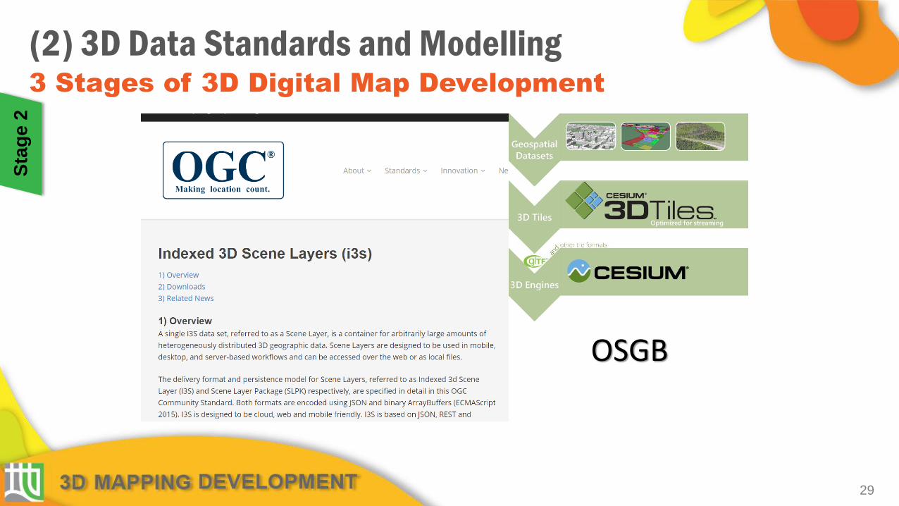
OSGB
(2) 3D Data Standards and Modelling 3 Stages of 3D Digital Map Development
29
Sta
ge
2

(2) 3D Data Standards and Modelling
30
OGC CityGML LOD specification for 3D city models / need improved specification (CityGML 3.0) ?
Source: http://filip.biljecki.com/phd.html
Stage 2Stage 1
3 Stages of 3D Digital Map Development

31
(2) 3D Data Standards and Modelling
OGC CityGML & IndoorGML
• Urban Planning / Operations• Emergency Mgt / Response• Transportation / Routing / Logistics• Indoor navigation• Retail Site analysis• Sustainable / Green Communities• City Services Management• Noise abatement• Telecommunications placement• Many other uses…
Source: http://www1.nyc.gov/site/doitt/initiatives/3d-building.page
Sta
ge
2
3 Stages of 3D Digital Map Development

32
3D Geometry with Information
Existing Topographic Dataset
FloorPoly
FloorPolyIDBuildingIDEnglishDisplayNameChineseDisplayNameHeadroomDataSourceLevelSourceBaseLevelRoofLevelNotes
UnitPoly
UnitPolyIDFloorPolyIDEnglishUnitDescriptionChineseUnitDescriptionUnitUsageBaseLevelRoofLevelNotesFloorPolyName
Building Site
FloorPolyID
BuildingID
1 *
*
1
(2) 3D Data Standards and Modelling S
tag
e 2
3 Stages of 3D Digital Map Development

33
FloorPoly
Attribute Description
FloorPolyID Unique ID
BuildingID Building which the floor situated at
EnglishDisplayName English Description (e.g. G/F, 1/F)
ChineseDisplayName Chinese Description (currently unused)
Headroom Headroom of the floor
DataSource Data Source of the information (e.g. building plan, BIM)
LevelSource Data Source of Floor Elevation
BaseLevel Base Level of the Floor
RoofLevel Roof Level of the Floor
Notes Notes and Remarks
UnitPoly
Attribute Description
UnitPolyID Unique ID
FloorPolyID Indicate the floor polygon it belongs to
EnglishUnitDescription Description of the unit as stated on plan
ChineseUnitDescription Description of the unit as stated on plan
UnitUsage Usage of the unit
BaseLevel Base Level of the unit
RoofLevel Roof level of the unit
Notes Notes and remarks
FloorPolyName State the floor name where the unit situated
(2) 3D Data Standards and Modelling S
tag
e 2 3D Geometry with Information
3 Stages of 3D Digital Map Development

(1) 3D Data Standards and Modelling
34
CIC (Task Force on BIM Standards Phase 2)
1. Standards for common BIM procedures such as project coordinates, project units model management and file naming convention
2. LOD Responsibility Matrix that sets out potential modelled elements by discipline and attaches a CAT Code to those elements.
DevB
1. BxP Execution Plan Template to advise the modelling methodology for discipline by providing examples of different elements typical for each discipline’s model and associated an object type to that specific element.
2. Update the DevB TC No.16/2000 for as-built and design BIM data

(2) 3D Data Standards and Modelling
35
2D GeoAddress (2019)
• an identifier to linking services and address related information maintained in B/Ds
3D GeoAddress Code (under planning)
• matching the proposed 2D GeoAddress
• unique identifier in floor and unit levels
• facilitate the development of more innovative applications
Address Data Infrastructure
3 Stages of 3D Digital Map Development

Comprehensive 3D Map Objects
Tree No. 5
Species Ficus
Height 5m
DBH 1m
Spread 4m
Health Good
Bldg No. 10
Use Industrial
Height 56m
Floor 17
Unit 100
Creation
Date
21/2/1995
• 3D maps for city modelling
Stage 3
• 3D maps for unit-based
indoor applications
Stage 2
• 3D maps for visualization
Stage 1
36
(2) 3D Data Standards and Modelling 3 Stages of 3D Digital Map Development

(2) 3D Data Standards and Modelling
37
International / national mapping standards Technology edge on 3D mapping Interview stakeholders
1:1000 Digital 2D Topographic Map (235 Features)
Study on 3D Digital Map Development

(3) 3D Data
Sharing
38

2017
(3) 3D Data Sharing
39
Provision of Services for the Study on
Integration of BIM data and 3D Spatial Data
PurposeTo create a BIM-friendly data environment to facilitate
works and land development processes
2018
Provision of Service ContractLandsD started a project for the study on Integration of BIM Data and
3D Spatial Data in March 2017 and completed in March 2018

(3) 3D Data Sharing
40
Provision of Services for the Study on
Integration of BIM data and 3D Spatial Data
Development Bureau
Government Departments
Construction Industry Council
Project Steering Committee Contractor Project Team
Project Manager
BIM Specialist
GIS Specialist
System Analyst
Interviewees

41
Simplification Result
▲Source BIM Data
▲Simplified BIM Data
▲Simplified FBX
▲ArcGIS & Skyline 3DSD
BIM data sharing for 3D map updating

42
As-built/Simplified BIM Data Repository

43
Release new BIM compliant data formats
for 3D Spatial Data
(3) 3D Data Sharing
2019
Source: Autodesk
IFC, CityGML or other formats (Proposing)
FBX format
NEW

44
- Define simplified BIM Standard- Establish BIM Data Repository
for map updating and proptech
Establish Building Information Modelling (BIM)
Data Repository
(3) 3D Data Sharing
As-built/Simplified BIM Data Repository PrototypeRevise Works Bureau Technical Circular No. 16/2000 –Provision and Collation of Land Survey and Mapping Data
Start Design and As-built Data Management System
2018
2019

Announce 3D Spatial Data updating schedule in 2019 to avoid duplication of work on 3D model creation and encourage data sharing
(3) 3D Data Sharing
45

Number of Existing Buildings (whole territory of HK)210,000 (about)
Types Buildings (Height >= 10m)53,000 (about) (25%)
Buildings (Height < 10m)157,000 (about) (75%)
Available in 2019 After 2019 Available in 2019 After 2019
3D Mesh Models(LandsD & PlanD)
45,000 (21%)
8,000 (4%)
87,000 (42%)
70,000 (33%)
Individualized 3D Building Models(LandsD)
28,000 (13%)
25,000 (12%)
18,000 (9%)
139,000 (66%)
Individualized 3D Building Models (Enhanced with Street-level Imagery)(LandsD)
800 (0.5%)
52,200 (24.5%)
nil 157,000 (75%)
(3) 3D Data Sharing
46
47
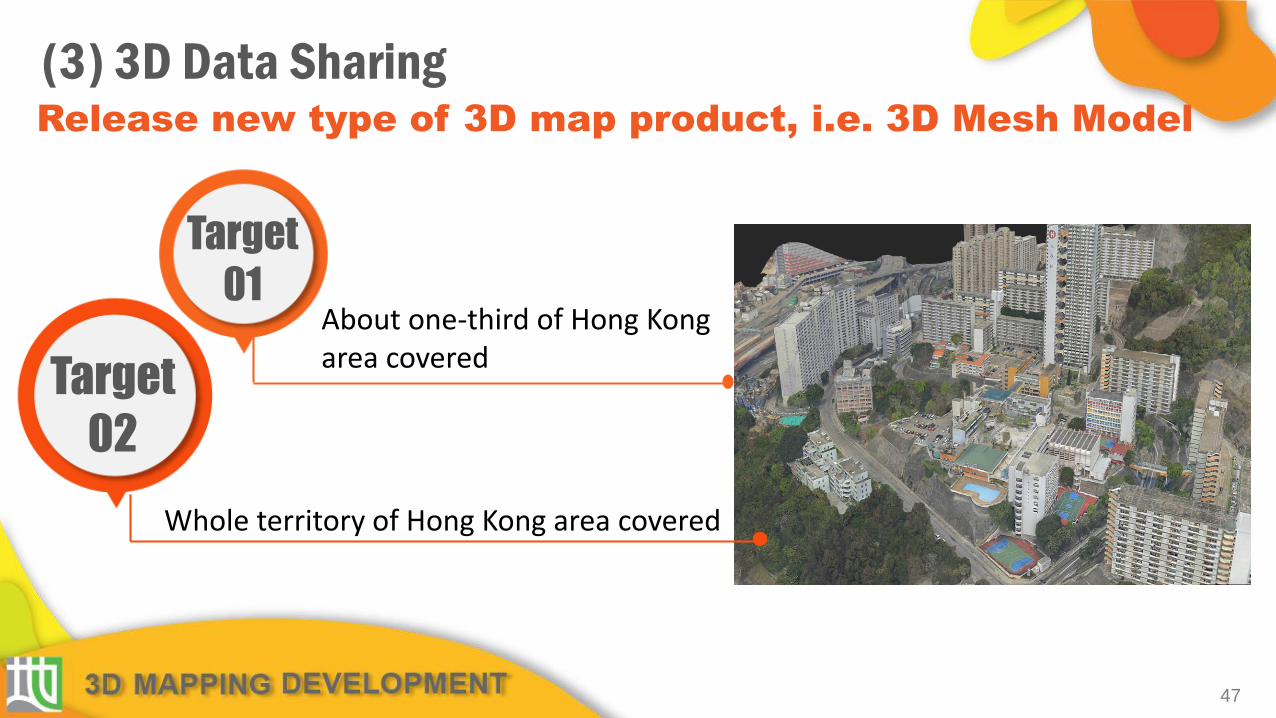
Release new type of 3D map product, i.e. 3D Mesh Model
(3) 3D Data Sharing
Target
01
Target
02
About one-third of Hong Kong area covered
Whole territory of Hong Kong area covered

3D Spatial Data publishing / updating schedule
(3) 3D Data Sharing
Target
03
Target
04
50% of about 210,000 individualized building
models updated in Level 2 / Level 3
All individualized building models updated in
Level 2 / Level 3
48

3D Data Sharing for Government Departments 3D Spatial Data Viewer for LandsD
49
3DXplorer in GIH for Government Departments

(3) 3D Data Sharing
50
3D Digital Map forms the basis of essential spatial data
and supports Common Spatial Data Infrastructure, CSDI
CSDI Digital Framework

51
Supported by 3D Digital Map
(3) 3D Data Sharing
CSDI Consultancy Study Institutional Framework
Construction 2.0ICMS, IPMS, ILMS Standards
Property Technology (PropTech)
Collaboration with BIM
Technology Convergence

CSDI Portal 3D Digital Map Positioning infrastructure
With the support of three building blocks Overseas Examples• National SDI (NSDI) for the United States
• INSPIRE(NSDI) for the European Union
• Abu Dhabi SDI• National SDI for Singapore
52
A Bridge between Digital and Real World - Digital Twin
CSDI – Digital Infrastructure for Smart City
Overseas example

What is the future 3D Map ?
53
Source: https://www.hel.fi/helscinki/en/administration/information/general/3d/3d
The models are available as open data
Example : Helsinki’s 3D City Models
2 Types of 3D Model3D Reality Mesh ModelCityGML 3D Information Model
includes a terrain model and individualized building modelsbuildings are presented in two formats: LoD1 - flat-roofedLoD2 - with differentiated roof structures and textured
Citizenry / City officials / Companies / Innovators
DATA UTILIZATION 3D Web services
Pilot portfolio
New work practices
UNITY
Open 3D data
Service and product Innovations
3D SPATIAL DATAINFRASTRUCTURE
DATA MAPPING LAYER / Import / Export / Update
GIS DATAPoint Clouds
Oblique Images
GIS DataBases Registers
IFC / InfreModel
New Geodata
3D REALITY MESH MODEL
CityGML3D INFORMATION MODEL

What is the future 3D Map ?
The models are free of charge, available for download in the Berlin 3D download portal
Source: https://www.businesslocationcenter.de/en/WA/B/seite0.jsp
Example : Berlin’s 3D City Models
Fully texturedIndividualized building models created by aerial photogrammetry and their roofs were measured with lasersVarious 3D formats including CityGML format
Digital Aerial Photos
Digital Terrain Models
Geo-referencedThematic Data
3D Geodata
Digital ArchitecureModels
Cadastral Data
3D Authoring SystemTemporary Models
3D Geo-Database SystemVirtual 3D City Model
Geodata Web Services WMS, WFS, W3DS
3D Presentation System
Real-Time 3D City Model
Geotainment & Digital Rights Management
Geodatai Infrastructure GDI Berlin Third-Party Applications and Systems
Administrative Applications Senate of Economics,Senate of Urban Planning, Berlin-Parther, …
End-Consumer Products, DVDs, etc.
CityGMLConverter
CAD and 3D Editor & Tools
ALK Converter
Berlin
3D
City M
od
el System
54

What is the future 3D Map ?
55Source: https://www.geospatialworld.net/blogs/singapores-smart-nation/
Example : Virtual Singapore
Dynamic 3D city model built of national 3D map developed with the use of LiDAR as well as real-time dynamic dataIntegrates data from government agencies, information from the internet, from IoT devices and sensorsVarious 3D formats including CityGML format

What is the future 3D Map ?
56
Source: https://www.rotterdam.nl/werken-leren/3d/
The models are available as free open data
Example : Rotterdam 3D
3D representation of the municipality based on a number of key registers, height data, data management and photographsIncludes buildings, trees, lampposts and cables and pipesVarious 3D formats including CityGML format

Collaborations among the Government, Industry, Academia and the Research Sector
57

58

59

• The Survey and Mapping Office (SMO) of the Lands Department is serving the community by
providing quality mapping services and products.
• We will consider the requirements for geospatial information (2D/3D) by:
- Continuing to play a key role in providing a reliable, trusted and maintained geospatial information base; and
- Providing data that is accessible, interoperable and standardised.
• The 3D Digital Map development in Hong Kong requires collaboration of the Government, Industry, Academia and Research sectors.
• Together, we can support the Hong Kong Smart City Blueprint and various smart city applications and developments.
Summary
60

"Coming together is a beginning,
staying together is progress,
and working together is success."
- Henry Ford
61
Henry Ford (the founder of the Ford Motor Company)
Source: https://www.goalcast.com/2018/05/28/20-teamwork-quotes/henry-ford2/

62