Embed Size (px)
Citation preview
8/6/2019 River Guide Book 2nd
http://slidepdf.com/reader/full/river-guide-book-2nd 1/45
The
Lackawanna
River Guide

8/6/2019 River Guide Book 2nd
http://slidepdf.com/reader/full/river-guide-book-2nd 2/45
The Lackawanna River GuideA publication of the
Lackawanna River Corridor AssociationSecond Edition
This Guide is dedicated tothe membership
of The Lackawanna River Corridor Association
whose support and commitment are helping to createa revitalized Lackawanna River.
©2002
This book is published by the Lackawanna River Corridor Association, 2006 North MainAvenue, Scranton, Pennsylvania 18508. This document was originally published with
assistance provided by the Scranton Area Foundation in 1994.
by Bernard McGurlExecutive Director, Lackawanna River Corridor Association
Second Edition editing by Arthur PoppProgram Manager, Lackawanna River Corridor Association
with contributions by:Daniel Townsend, Ph.D., Flora & Fauna
Len Gorney, FishingDominic Totaro, S.J., Canoeing
Jack McDonough, Editorial AssistancePamela Lomax, Proofreading
Deilsie Heath Kulesa, Typesetting

8/6/2019 River Guide Book 2nd
http://slidepdf.com/reader/full/river-guide-book-2nd 3/45
TABLE OF CONTENTS
INTRODUCTION
Chapter I…………………….1The Valley and the River
Chapter II…………………..12The Lackawanna River Corridor Association
Chapter III………………….18
River Access
Chapter IV…………………25Fishing
Chapter V…………………27Canoeing
Epilogue…………………..30
Appendix…………………31
River Terms…………..….34
Recommended Reading…38
Trail Maps…………….…42
~

8/6/2019 River Guide Book 2nd
http://slidepdf.com/reader/full/river-guide-book-2nd 4/45
Introduction
"The Lackawanna… takes its name from the Indian tongue and signifies the meeting of two streams…once abounding in fish of every variety, particularly known for its brook trout…gliding silently by over the gravelly bars dancing in the sunshine…a river of the
purest spring water…along its banks, thick with hemlock, oak and pine were deer andmoose…among groves of rhododendron and laurel."from A History of The Lackawanna Valley,Dr. Horrace Hollister, 1869
The Lackawanna River rises and flows through a three-hundred fifty square milewatershed in four counties of Northeastern Pennsylvania. The twenty-threemunicipalities in the watershed are home to nearly one quarter of a million people.
This guide is written for the people of the Lackawanna Valley: long timeresidents, newly arrived neighbors and visitors. The Lackawanna River has a powerful
and subtle relationship with us. This guide will help to explore our relationship with theRiver and examine what the River tells us and the rest of the world about thatrelationship.
The Lackawanna River Guide will help ask and answer many questions. It willhelp us evaluate our stewardship of the River and its watershed. It will help make theRiver a more familiar friend, a resource that each reader can get to know through theseasons of life.
The Lackawanna River Guide is a work in process as human consciousness isitself a work in progress. This edition, written at the end of the 20th Century offers avision for the future as well as an analysis of today and yesterday. Your experiences andcomments can help guide the next generation. The Lackawanna River Corridor
Association welcomes your company as we journey along the River. We encourage your involvement with us. We need your participation to help make the Lackawanna Valley a better place to live.
Chapter I
The Valley and The River
The Lackawanna River takes its name from Lech –uh’ wanna, a Lenni Lenapi wordmeaning stream that forks. The Lenapi, an Algonquian speaking tribe, inhabited the
Delaware and Upper Susquehanna Valleys at the time of European settlement. Thewords Lehigh and Lackawaxen may also derive from the same Algonquian word.
The sixty-two mile long Lackawanna River drains a three-hundred fifty squaremile watershed in four counties of northeastern Pennsylvania: Susquehanna, Wayne,Lackawanna, and Luzerne.
The River rises in two branches from a number of glacial ponds and wetlands onthe Allegheny - Pocono plateau along the Wayne - Susquehanna County line. The east
branch flows from Lake Lorain, Bone Pond, Independent Lake, and Dunns Pond to meetthe west branch which flows from Fiddle Lake, Lake Lowe, and Lewis Lake. The east
1

8/6/2019 River Guide Book 2nd
http://slidepdf.com/reader/full/river-guide-book-2nd 5/45
and west branches converge at Stillwater Dam near Pennsylvania Route 171 in UnionDale.
Just below the Dam, the Lackawanna passes scenic Stillwater Cliffs and begins itsforty-mile course through the northern anthracite coal field to its confluence with theSusquehanna River at Coxton between Duryea and Pittston in Luzerne County. The
Lackawanna is the largest tributary to the North Branch of the Susquehanna River in Northeastern Pennsylvania. Eventually, the waters of the Lackwanna flow into andthrough the Chesapeake Bay.
The confluence with the Susquehanna River at Pittston
Geography
From its sources at an elevation of 2,000 feet above sea level to its confluencewith the Susquehanna at an altitude of 500 feet, the Lackawanna River drops an averageof 39 feet per mile. The River and its tributaries form a dendritic drainage pattern. TheLackawanna has 76 tributaries. Some of the larger tributaries are Roaring Brook, SpringBrook, Leggetts Creek, Keyser Creek, Hull Creek, Eddy Creek, Grassy Island Creek,White Oak Run, Aylesworth Creek, Rush Brook, Racket Brook and Fall Brook. TheLackawanna River watershed forms a northern extension of the Appalachian Ridge andValley Physiographic Province. This province is characterized by long, parallel ridges.The Lackawanna\Wyoming Valley forms a physiographic boundary dividing theAllegheny and Pocono Plateau provinces. The mountain ranges which form the valleyare on the west the Lackawanna Range and on the east the Moosic Mountains.
The region experienced several eras of glaciation. The last, the Wisconsin IceAge, began to recede about twelve thousand years ago. The glacier's retreat left the plateaus covered with thousands of lakes, bogs and ponds. The 47 inches of averageannual precipitation help to replenish these wetlands and ponds providing a constant or
perennial flow to the Lackawanna and many of the other tributary streams in the upper Susquehanna and Delaware basins.
2

8/6/2019 River Guide Book 2nd
http://slidepdf.com/reader/full/river-guide-book-2nd 6/45
Geology
The real story of the Lackawanna begins long before the glaciers of the last ice age. TheAppalachian Mountains are one of the oldest geological features on the planet. Themountain building occurred between 250 and 500 million years ago during the Paleozoic
era. The rocks of this region were alternately parts of the ocean floor in the Devonian period, the great swamps of the Carboniferous period, or the folded and upliftedsedimentary rocks of the Permian age.
The presence of anthracite coal has had the most significant impact on our presentday Lackawanna River. Anthracite was formed from the dead vegetation of theCarboniferous age swamps. As time passed, the swamps were covered with oceansediments which form the shale and sandstone layers we find between the coal veins.The pressure and heat of the overlying sediments and the folding rise of the AppalachianMountains gradually turned the vegetation into peat then lignite, bituminous and, here inthe northeast region where the geologic pressure was greatest, anthracite-the hardest,highest carbon content of all coal.
The anthracite coal beds of Pennsylvania are known as the Llewellyn formation.In the Lackawanna and Wyoming Valleys, the coal bed sits in an older and harder rock formation known as the Pottsville or Pocono Conglomerate. This hard, whitish capstoneis a metamorphic rock compound of quartz pebbles and sand. It resembles a very hardconcrete. These rocks are visible around Lake Scranton, along Roaring Brook at NayAug Falls, and the Moosic and West Mountain ridge tops. Many large retaining walls,
bridge abutments, building foundations and reservoir dams were cut from this very hardstone during the last century.
The boundary between the Pottsville and Llewellyn formations runs along theflank of the Valley about half way up the Mountains. This boundary where the coal veinsoutcrop was chosen as the site of many of our water supply reservoirs.
The Llewellyn Formation was once estimated to contain two billion tons of coal.Some geologists have speculated that ten to twenty billion tons once existed, but werelost over the ages from erosion and glaciers. The coal seams in the Lackawanna Valleyare found at various depths, averaging 30 feet to 700 feet below the surface. The beds arein order from the surface:
Number 1 or Big bed Number 2Upper 4 foot4 footDiamondRock
Rider 14 foot New CountyClark Dunmore Numbers, 1, 2, 3, and 4
The Number 1 bed is found on the east side of the Lackawanna River. It ranges inthickness from 10 to 20 feet in places. It pitches out at or near the surface in somelocations. At one spot near the Mercy Hospital in Scranton's Hill Section, it was within 3
3

8/6/2019 River Guide Book 2nd
http://slidepdf.com/reader/full/river-guide-book-2nd 7/45
feet of the surface. One day in the 1890's, miners dug right into some neighborhood backyards in their quest for coal!
The deepest beds, the Dunmore Number 4 are as much as 800 feet below thesurface. The Brisben shaft of the Glen Alden Company in North Scranton and the GrassyIsland shaft of the Hudson Coal Company, Olyphant reached the Dunmore Number 4.
Today much of the anthracite remaining in the Valley is to be found in the Dunmoreveins under 600 feet of mine water.
Flora and FaunaPlants
The Lackawanna Valley is rich in bio-diversity. Situated along a climatalogical boundary between the northern and southern regions of the eastern deciduous forest, theValley is home to a wide variety of trees, shrubs, and herbaceous plants.
The quotation from Dr. Horrace Hollister at the preface of this book sketches an
idyllic picture of what the River and its habitat was like at the beginning of the 19thCentury. Hemlock, oak and pine formed the canopy forest in the valley, the understorywas thick with rhododendron and laurel. Other canopy species such as the Americanchestnut and elm were also common and plentiful. Much of the original habitat andforest cover was cut for fuel, railroad, mining, and construction uses. Since the early20th Century, a fairly diverse secondary forest cover has developed. There are a fewlocations in the Valley where small remnants of the original forest may remain. One or two acres here and there in some steep and remote glens along the mountains holdhemlocks over a century old.
Today a riparian forest shades the River and keeps its waters cool during the hotsummers. River birch, red maple, willow, elm, alder and sycamore are found along many
reaches of stream where mining and urban development impacts have lessened. Many of the native understory species struggle against Asiatic knotweed, a bamboo like specieswhich has become endemic throughout the Appalachian Mountains. Knotweed grows by
both seed and rhizome. The root system sends up new shoots and chokes other speciesout. A mass of knotweed along the riverbank may look like thousands of individual
plants, but may actually be one organism. The acclamation of knotweed to theAppalachian region is a reminder that northeastern China contains a mirror image of Appalachian geologic, topographic and ecologic features; from anthracite coal, to broad-leafed deciduous forests.
The upland areas of the Lackawanna River watershed have a variety of plantcommunities influenced by altitude, soil depth and moisture. Wetlands occur along the
River and flood plain and along the Moosic and West Mountains and the Pocono plateau.Wetlands are home to the heath family; sheep laurel, mountain laurel, high bush blueberry, as well as cattails, and water lily. Hemlock, black spruce, tamarak, swampoak, and black gum form the canopy layer in wetlands and upper tributary streamcorridors.
The ridge tops and Pocono plateau are the home of a globally unique dry site plant community: the scrub oak/pitch pine dwarf tree forest. Due to shallow rocky soilsand rough weather conditions, the oak and pine which grow along the summits are
4

8/6/2019 River Guide Book 2nd
http://slidepdf.com/reader/full/river-guide-book-2nd 8/45
stunted and only reach five to fifteen feet in height even when fully mature. The ridgetops of the Moosic range also host an Arctic sedge community. Northern grasses,huckleberry, sheep laurel, and other heath plants grow in the sparse soil between outcropsof Pocono Conglomerate. These Arctic plants, including reindeer lichens, are vestiges of the last ice age. The Moosic range is the furthest southern habitat of these plants,
commonly found in the Adirondacks or northern Quebec.In addition to the rare scrub tree and heath community along the ridge tops, theRiver and watershed host a variety of plants which are listed as rare by the Pennsylvania
Natural Diversity Inventory. Many of these are wetland or aquatic species. The listincludes:
• Small floating manna-grass ( Glyceria borealis )• Sweet bayberry ( Myrica gale )• Many-fruited sedge ( Carex lasiocarpa )• Floating heart ( Nymphoides cordata )• Bayonet rush ( Juncus militaris )• Jacob's ladder ( Polemonium vanbruntiae )• Golden club ( Orontium aquaticum )• Water lobelia ( Lobelia dortmanna )• Purple Bladderwort ( Utricularia purpurea )
Fisheries
The Lackawanna River was once famous for its native brook trout. Early coal prospectors and industrialists such as William and Maurice Wurts and William Henrylived on brook trout as they wandered through the Lackawanna region in search of richesin the 1820's. The iron, coal, rail and textile industries, and the towns which sprung upalong the River, virtually destroyed the fishery by 1900. But the Lackawanna has all theingredients for a vibrant trout fishery. The River has rebounded significantly during the
past thirty years. When the mines shut down and the communities built modern sewer treatment systems, the recovery gradually began. The Fish Commission began stocking
programs and sporting groups in the upper valley supplemented these efforts. The prevalent species of trout today is the brown trout. This European import is a bit more pollution tolerant than the native brook trout.
The Fish Commission and the Pennsylvania Department of EnvironmentalResources Bureau of Water Resources conducted water quality and fishery studies on theLackawanna River in 1991. These studies documented some improvements to water quality and fishery habitat. The Fish Commission has since reclassified the Lackawanna
between its headwaters and the Lackawanna Avenue Bridge in Olyphant as a high qualitycold water fishery with a section between Jessup and Jermyn listed as Class "A" TrophyTrout waters. (See a further discussion of this fishery, Chapter 3)
The Lackawanna, while predominately a cold-water fishery above Scranton, alsosupports a variety of warm water fish such as bullhead, bass, perch, and blue gill
particularly in the lower portions of the river. A number of non-game fish such asdarters, dace, chub, minnow, sucker and carp are also found .
The lower three miles of river are severely affected by drainage from the Old
5

8/6/2019 River Guide Book 2nd
http://slidepdf.com/reader/full/river-guide-book-2nd 9/45
Forge Bore hole, which dumps over one-hundred million gallons of mine water into theRiver everyday. Loaded with iron, aluminum, manganese and sulfur, this water is veryacidic and extremely low in dissolved oxygen. This reach of the River does not support afishery or any significant aquatic community.
Wildlife
While the timber wolf, mountain lion, and moose are no longer found innortheastern Pennsylvania forest, the undeveloped areas of the Lackawanna watershedare habitat to over 60 species of mammals and 170 species of birds.
Black bear and white tail deer predominate with fox, beaver, muskrat, mink, andsome bobcat. Many urban tolerant species such as squirrel, raccoon, woodchuck, skunk,and opossum are found in the more developed portions of the river corridor. The beaver is also becoming an urban pioneer. A beaver lodge was found along the River in thevicinity of Central Scranton in 1991.
The river otter, a Species of Special Concern in Pennsylvania, is also on the returnin both the upper and lower valley.The Lackawanna is a stop in the Atlantic Flyway for migratory birds. In addition
to waterfowl such as Canada goose, a variety of ducks from mallards to mergansers visitthe River on seasonal migrations. Many of the ducks are permanent residents. Great
blue herons also reside along the Lackawanna. The snowy egret has recently been seenin Scranton. Osprey, a large fish hawk, are making a comeback after being re-introducedin the upper Susquehanna basin by the U.S. Fish and Wildlife Service. Coopers hawks,redtail hawk, and the great horned owl are among the predators found on occasion in thewatershed. A pair of juvenile American bald eagles were sighted along the River in1994, the first report of this magnificent bird on the Lackawanna in decades.
One group of birds which is getting more attention from wildlife biologists are theneo-tropical migratory birds such as the robin, warbler, finch, and verio. These songbirdsoften use stream corridors and mountain ridges in their migrations. The LackawannaValley and the ridge tops may be important corridors for these bird migrations.
History
The documented human history in the Lackawanna Valley goes back 9,000 years.After the retreat of the last glacier, the area was populated by Neolithic ancestors of
Native Americans. Evidence of mid-archaic habitation has been uncovered near the
confluence of the Lackawanna and Susquehanna Rivers. Archeologists have discovered pottery shards and primitive tools made from flints and animal bones buried in deep river sediments at the confluence.
During colonial times, the Lackawanna Valley was the southern border of the Six Nations Iroquois Confederacy. The Capouse Clan of the Lenni Lenape Tribe (also calledthe Delaware Indians) had an extensive village along the River and adjacent uplands inthe area near Weston Field and Tripps Park. The Moravian missionary from Bethlehem,Count Zinzendorff visited Capouse in 1755. The French and Indian War and the
6

8/6/2019 River Guide Book 2nd
http://slidepdf.com/reader/full/river-guide-book-2nd 10/45
American Revolution saw the advance of European settlement and geo/politics thatgradually subdued the Native Americans. The last effort of the Iroquois to resistoccurred in 1778 when a British Tory and Iroquois war party descended on the Wyomingand Lackawanna region destroying the colonial settlements. The following year anAmerican army under General John Sullivan marched from Easton to Wilkes-Barre and
up the Susquehanna to the Iroquois heartland in the Finger Lakes region of New York.Sullivan's march destroyed the Iroquois as a political, military and economic power, andopened the way for American settlement in the upper Susquehanna Basin.
This area of Pennsylvania was once claimed by Connecticut and many earlysettlers were from that state. The Connecticut road into northeast Pennsylvania followedthe Minisink Trail from the Delaware River near Port Jervis across the Poconos, up theWallenpaupack Creek to the summit of Moosic Mountain and down through Dunmore toCapouse Meadows. Settlers widened the native footpaths to accommodate their ox carts.Traces of this road are visible today along the mountain top.
In 1780 the Slocum family established a grist mill along Roaring Brook. TheMerrifields, Tripps, and von Storches had farms to the west and north in the villages of
Hyde Park and Providence.In the years between the Revolution War, the War of 1812 and the 1820's , the useof anthracite coal became more common. Prior to the 1820's, charcoal had been the chief fuel for both domestic and industrial purposes. The demand for charcoal led to higher
prices and deforestation around the coastal population centers. This increasing demandfor fuel encouraged the search for alternatives to charcoal. By the 1820's, the anthracitecoal of northeastern Pennsylvania was recognized as a viable alternative.
At that time, this part of Pennsylvania was a wild and remote place. The largesttowns were Dundaff near Carbondale and Wilkes-Barre. There were only severalhundred citizens in these "population centers". In between, over vast distances of heavilyforested mountains, were a scattering of farming hamlets with a grist mill or cross roadtavern here and there.
Coal and Iron
The coal fields of the Lackawanna Valley were developed between the 1820's and1850's by two major entrepreneurial groups. The Delaware and Hudson Companyformed by William and Maurice Wurts and the Lackawanna Coal and Iron Companyheaded by George and Selden Scranton.
The development of the anthracite industry lead to breakthroughs in industrial andtransportation technology. The Delaware and Hudson Canal Company built a canal from
the Hudson River to Honesdale by 1829 and a gravity railroad from Honesdale over theMoosic Mountain to Carbondale, then known as Ragged Island. While the canal andgravity railroad went into operation in 1829, the company had opened its first mine alongthe river in 1822. Thus began a century of industrial manipulation and impact on theRiver.
Down stream and a few years later in 1840, the Scrantons, who operated an ironfurnace in Oxford, New Jersey, bought the Old Slocum mill site along Roaring Brook.The discovery of iron ore along Stafford Meadow Brook near present day MontageMountain, led the Scrantons to build new iron furnaces at Slocum
7

8/6/2019 River Guide Book 2nd
http://slidepdf.com/reader/full/river-guide-book-2nd 11/45
Hollow. The site had all the ingredients for industry: water power from the brook, coaldeposits on the hillsides and iron ore from the mountains. Their venture nearly faileddue to the difficulties in using anthracite to smelt iron and the challenges of marketing a
product so far from any significant market. But in 1847 their efforts were rewarded.There was an economic trade war between England and the United States. High demand
and tariffs on railroad iron dried up the supply of imported iron T rail from England. TheErie Railroad was building a line from New York City to Buffalo. The Erie wasrunning out of rail near Binghamton and would lose its franchise if the line was notcompleted. By September 1847, the Scrantons were rolling T rail along Roaring Brook and shipping it north by horse and mule teams and ox carts. Farmers from fifty milesaround were hired with their teams and wagons. Lackawanna iron T rail helped the Eriemake its deadline with four days to spare!
Lackawanna Station
Aside from the D&H Canal and Gravity Railroad, wilderness roads like thePhiladelphia and Great Bend Turnpike, which passed up the Wyoming and LackawannaValleys and through the notch along Leggetts Creek, were still the main transportationroutes in and out of the Valley. With the success of the rail making, the Scrantons andtheir partners began to build the Cobbs Gap and Delaware Railroad up Roaring Brook and across the Poconos to the Delaware Valley and connections with New Jerseyrailroads. The Lackawanna and Western Railroad was built through the notch andnorthward to connect with the Erie at Great Bend. In 1852, these roads were merged to
become the Delaware Lackawanna and Western Railroad (DL&W).Railroads and canals followed the rivers and streams in and out of northeast
Pennsylvania. The Lackawanna and its tributaries, Roaring Brook, Spring Brook,Leggetts Creek, and Racket Brook all had railroads along them by the 1880's. Theconfluence area at Coxton saw the growth of a large rail yard for the Lehigh ValleyRailroad as well as a canal boat basin on the North Branch Susquehanna Canal. TheDL&W rail yard developed between Roaring Brook and the Lackawanna River andis now the site of Steamtown National Historic Site. The Delaware and Hudson (D&H)rail yard developed at Carbondale where Racket Brook joins the River, the original site of Ragged Island. The Pennsylvania Coal Company Gravity Railroad and later the Erie
8

8/6/2019 River Guide Book 2nd
http://slidepdf.com/reader/full/river-guide-book-2nd 12/45
Railroad erected large shops along Roaring Brook in Dunmore, now the site of DeNaplesAuto Parts.
Water Supply and Sanitation
While railroad and mining companies developed and communities began to grow,the impacts on the once pure Lackawanna River began to have their effects.
In 1866, the year the boroughs of Hyde Park and Providence merged withScranton to form the city, the River was declared unfit for public water supply. Theexpansion of underground mining began to pollute both the River and the drinking wellaquifers in the valley. The River had become a convenient depository for the new sewers
being built under the streets and roads of the growing towns. This practice continued upto the 1960's!
In order to allow the economic development of the valley to continue, sources of clean potable water needed to be developed. The earliest public utilities began in the late
1850's. Gas companies manufactured coal gas and piped it to homes and businesses for lighting and cooking. Water companies were developed at the same time to serve thegrowing towns. As mentioned earlier, water supply reservoirs, which are still in usetoday were built along the Moosic and West Mountain ranges just past the geologic
boundary of the coal formations. This water supply system and its adjacent watershed,now owned by the Pennsylvania American Water Company, has the capacity to supplythe residents of the Lackawanna and Wyoming Valleys with a clean and abundantvolume of water.
In recent years, suburban development near some of the reservoir recharge areashas caused water quality problems. Expensive water filtration plants have been built toinsure a potable water supply. Concerns for the future vitality of our watershed are
important considerations as we enter the 21st Century.The wisdom of building the water supply system in the last century allowed andencouraged the growth and development of the Lackawanna Valley. The story at theother end of the pipe was somewhat different. By the 1920's, vast stretches of theLackawanna River were dead. Mine drainage, silt and erosion from strip mines and coal
breakers, municipal sewage, garbage and slaughter house waste wreaked havoc on theonce pure Lackawanna, all in the name of progress.
By the time of World War I, modern sanitation practices and technology had begun to emerge. Some progressive communities developed municipal sewage treatmentauthorities and plants.
Primary treatment technology existed to remove wastes and chlorinate waste
water before discharging into our streams, lakes and rivers. Public health regulationsgave the state authority to require local communities to develop and install sanitarytreatment works.
The Pennsylvania General Assembly passed a clean streams law in 1937. This actwas one of the first in the country to consolidate water quality regulations and requireenforcement of its provisions. It exempted coal companies, however.
Beginning in 1920, numerous civic improvement associations began to advocatethe cleanup and restoration of the Lackawanna River. By the time of the Depression inthe 1930's, the communities of the Lackawanna Valley did not have the taxing ability to
9

8/6/2019 River Guide Book 2nd
http://slidepdf.com/reader/full/river-guide-book-2nd 13/45
develop the necessary treatment facilities. Local officials resisted the efforts of citizens'groups and state bureaucrats to do what needed to be done. Many argued that the
pollution from the mines neutralized the health threats from the sewage. This "twowrongs make a right" argument continued into the 1960's.
What was true for the Lackawanna Valley towns was common place around the
country as well. Federal legislation eventually provided state and local agencies with thefunding needed to make the construction of publicly owned sewage treatment facilitiesaffordable. The City of Scranton and Dunmore Borough created the Scranton Sewer Authority in 1966. One hundred years after the River was declared undrinkable Ð afitting birthday present for the city. The Lackawanna County Commissioners created theLackawanna River Basin Sewer Authority a few years later to serve towns in the mid andupper valley as well as Moosic. Taylor and Old Forge joined with Avoca, Duryea, andPittston Township in Luzerne County to form the Lower Lackawanna Sanitary Authorityin 1975. Communities in the Abingtons formed a joint authority in 1975 as well.
Townships in the north Pocono area developed separate authorities and haveencountered more problems due in part to the topography and development patterns of
this growing area. With the Penn Vest program developed by Governor Robert Casey,our local governments now have the funding assistance necessary to keep in compliancewith clean water requirements.
The End of Mining
The years around 1960 were significant for the Lackawanna River. On January29, 1959 the Knox Mine Disaster occurred in Pittston. Miners were stealing pillars of coal from under the bed of the Susquehanna River when a charge set to loosen coalcaused the riverbed to collapse into the mine. This disaster permanently flooded the
underground mines in the Wyoming and lower Lackawanna Valley. It was the deathknell for what was left of the anthracite industry. The last underground mine in theLackawanna Valley, the Continental Mine, shut down in 1966. (This mine is now theLackawanna Coal Mine at McDade Park).
With the end of underground mine operations, the thousands of mine tunnels andvoids under the valley filled up with ground water and surface water which infiltratesthrough strip mines and stream beds. All this water has to go somewhere, and thatsomewhere is the River! From Forest City to Duryea, there are over a dozen tunnels,shafts or bore holes where mine drainage flows unchecked into the River. There are alsohundreds of other locations where mine water seeps through hillside springs and intonearby streams.
The body of water under the Lackawanna Valley is known as the NorthernAnthracite Mine Pool. If it were a lake on the surface, it would rival one of New York'sFinger Lakes in size -- at least in area. As water percolates through the abandoned minevoids, it picks up metallic compounds and minerals from the coal and the rocks betweenlayers of coal. Iron, aluminum, manganese and sulfur compounds are dissolved in themine water. The mine pool water is largely anaerobic or lacking in dissolved oxygen.Mine water is also highly acidic having a pH between 3 and 6. When this water reachesthe surface and enters a river or stream, the metallic sulfide compounds tend to seek out
10

8/6/2019 River Guide Book 2nd
http://slidepdf.com/reader/full/river-guide-book-2nd 14/45
dissolved oxygen in the surface water. The acidic sulfides bond with the dissolvedoxygen and precipitate out of solution. This chemical reaction coats the rocks in andalong the riverbanks with a characteristic yellow-orange coloring. Miners called thesubstance "yellow boy".
Flooding
On August 18, 1955 Hurricane Diane traveled up the east coast and rained itself out over the Lackawanna Valley and the Pocono Mountains. Roaring Brook and theLackawanna River surged out of their banks during the night. Large portions of Carbondale, the Mid-Valley and Scranton were flooded out. Thousands of residents wereleft homeless, entire neighborhoods were destroyed, never to be rebuilt.
Flooding is a regular occurrence along rivers and streams. Sometimes there is justtoo much water. The Lackawanna Valley has experienced major flooding every twenty-five to thirty years, sometimes more frequently. Because flat level land is at a premium
in the Valley, many neighborhoods were built on the river flood plain. The floods of 1902, 1936, 1942, 1955 and 1975 caused widespread damage along the River. Localcitizens and officials pressed state and federal agencies for a flood protection program.Following the flooding of 1955, the United States Army Corps of Engineers constructed alevee and floodwall system along Roaring Brook at its confluence with the LackawannaRiver in South Scranton "Flats" neighborhood.
In 1960, the Corps of Engineers built Stillwater Dam where the east and west branches of the Lackawanna join near Uniondale. Stillwater is basically a dry damdesignated to hold back the immense volume of water from a one-hundred year stormevent. Its capacity was tested in 1972, 1975 and again after the blizzard of the century inMarch 1993.
Stillwater and other state flood protection levees have provided a margin of security for many downstream flood plain neighborhoods.The flooding which occurred after Hurricane Gloria in September of 1985 had
much to do with subsequent development in the Mid-Valley and the Abingtons above theScranton neighborhoods. In addition, several new bridges in Scranton at AlbrightAvenue and Poplar Street may have contributed to the 1985 flooding. The River floodedin January 1996 after a mid-winter thaw and heavy rainstorm. Citizen groups petitionedstate and federal officials for additional flood control projects. Additional levees are
proposed in the Plot and Green Ridge neighborhoods in Scranton and in Dickson City.Several groups of homes along the river were demolished using Federal EmergencyManagement Agency (FEMA) funds.
A knowledge of the natural and human history along the Lackawanna River canlead us to recognize and benefit from the dynamics of the River's relationship with us.An understanding of the River's personality can help our community realize the valueswe receive from this natural resource. As we come to respect the River, we can see whatit offers to us for today and tomorrow.
11

8/6/2019 River Guide Book 2nd
http://slidepdf.com/reader/full/river-guide-book-2nd 15/45
Chapter II
The Lackawanna River Corridor Association
The Lackawanna River shares much with the great rivers of America. Like thePotomac and the Mississippi, the Lackawanna has retained its Native American name.Like so many of our majestic rivers, its waters have been tapped for power andsustenance for growing communities. The Lackawanna has also been abused; perhaps a
bit more than other rivers. Yet, the Lackawanna has always had friends even in itsdarkest days when it ran black and red with coal and slaughter house waste.
In 1987, the Lackawanna River gained a new friend or more accurately, hundredsof friends. Several hundred citizens joined together and formed the Lackawanna River Corridor Association known by friends of the River as the LRCA.
The citizens task force which formed the LRCA defined a broad mission for theAssociation to promote the restoration and protection of the Lackawanna River and itswatershed resources and to involve the entire community in the process. The LRCAorganized as a tax exempt non-profit corporation and developed a series of goals to helpthe community revitalize the Lackawanna River.
The LRCA learned that the National Park Service which was developing the newSteamtown National Historic Site offered assistance to local river conservation groups.The Park Service co-hosted several public meetings during the summer and fall of 1987.These meetings led to the LRCA's Lackawanna River Citizens Master Plan (CMP). TheLRCA received a challenge grant from the Scranton Area Foundation and matched stateand Park Service funding to begin the CMP study in 1988.
For two years the LRCA volunteers worked with Chuck Hoffman, a noted river conservation planner and a team of Park Service and local planners. All aspects of theRiver were studied and problems were identified and assessed. Case studies from other rivers and communities were prepared and opportunities for projects to benefit theLackawanna River were identified.
In 1990 the LRCA published the Lackawanna River Citizens Master Plan. The plan has four major goals and recommendations. The first is Project River Clean, acomprehensive environmental cleanup of the River including upgrades to sewer facilities,treatment of mine drainage, restoration of natural habitat and removal of trash and debris.
Public involvement, awareness and education is the second recommendation. Itaddresses our community's need to understand and value the River and stream corridor habitats.
Thirdly, a Lackawanna River Park or Greenway system, is proposed using river levees and abandoned railroad beds to develop a trail and access system joining existingneighborhoods, parks, and commercial areas together.
A Lackawanna River Partnership is the fourth major recommendation of themaster plan. The partnership involves the LRCA, local civic organizations and private
property owners working together with local, state, and federal agencies to develop clean-up, recreation and educational programs and to coordinate all efforts to improve andrestore the Lackawanna River.
The work of the Lackawanna River Partnership is spelled out in the CitizensMaster Plan in an Agency Action Agenda. The LRCA and its planning partners
12

8/6/2019 River Guide Book 2nd
http://slidepdf.com/reader/full/river-guide-book-2nd 16/45
identified all local, state and local agencies with jurisdiction or programs related to theRiver. These agencies include local departments of public works and sewer authorities,the various bureaus of the Pennsylvania Department of Environmental Protection, theU.S. Environmental Protection Agency, National Park Service, US Army Corps of Engineers and Bureau of Mines. Projects and responsibilities were identified and actions
were recommended.
Tree and shrub planting along the River on Nay Aug Ave., Scranton
The plan has received the backing and endorsement of the Lackawanna CountyCommissioners and many local municipalities through resolutions adopted by councils.The restoration efforts moved ahead during 1992-1993 with the completion of aLackawanna River Greenway Study by the Corps of Engineers, the National Park Serviceand the LRCA.
The Corps portion of the study developed project recommendations to deal withacid mine drainage, abandoned mine lands, river habitat restoration and innovativeimprovements to the sanitary sewer system. The Park Service component built on LRCArecommendations for a greenway trail and recreational access points along abandonedrail lines parallel to the River.
Since 1989 the LRCA has worked closely with the Lackawanna Heritage ValleyTask Force which developed the Plan for the Lackawanna Heritage Valley and therecently created Lackawanna Heritage Valley Authority (LHVA).
The LRCA is working with the LHVA to begin building the Greenway trail. InJuly 1993 the first link in the trail was inaugurated with the Bridge at Heritage ValleyCrossing. This one-hundred fifty foot steel arch pedestrian bridge crosses over the
Lackawanna River between Blakely and Olyphant. It joins the trails of Robert MellowPark in Blakely with Philip Condella Park in Olyphant.The next link is underway from Mellow Park through Winton on the old Ontario
& Western rail bed to Laurel Park in Archbald. In September 1994, the LRCA securedadditional funds for several more strategic miles of Greenway trail in north Scranton,Archbald, Jermyn, Mayfield, and Carbondale. The Lackawanna River Heritage Trail isenvisioned to follow the River for forty miles, linking with rail trails in Luzerne Countyto the south and Wayne and Susquehanna Counties to the north and east. There are other
13

8/6/2019 River Guide Book 2nd
http://slidepdf.com/reader/full/river-guide-book-2nd 17/45

8/6/2019 River Guide Book 2nd
http://slidepdf.com/reader/full/river-guide-book-2nd 18/45
8/6/2019 River Guide Book 2nd
http://slidepdf.com/reader/full/river-guide-book-2nd 19/45
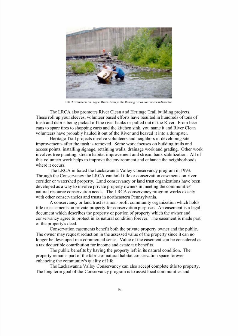
LRCA volunteers on Project River Clean, at the Roaring Brook conflunece in Scranton
The LRCA also promotes River Clean and Heritage Trail building projects.
These roll up your sleeves, volunteer based efforts have resulted in hundreds of tons of trash and debris being picked off the river banks or pulled out of the River. From beer cans to spare tires to shopping carts and the kitchen sink, you name it and River Cleanvolunteers have probably hauled it out of the River and heaved it into a dumpster.
Heritage Trail projects involve volunteers and neighbors in developing siteimprovements after the trash is removed. Some work focuses on building trails andaccess points, installing signage, retaining walls, drainage work and grading. Other work involves tree planting, stream habitat improvement and stream bank stabilization. All of this volunteer work helps to improve the environment and enhance the neighborhoodswhere it occurs.
The LRCA initiated the Lackawanna Valley Conservancy program in 1993.
Through the Conservancy the LRCA can hold title or conservation easements on river corridor or watershed property. Land conservancy or land trust organizations have beendeveloped as a way to involve private property owners in meeting the communities'natural resource conservation needs. The LRCA conservancy program works closelywith other conservancies and trusts in northeastern Pennsylvania.
A conservancy or land trust is a non-profit community organization which holdstitle or easements on private property for conservation purposes. An easement is a legaldocument which describes the property or portion of property which the owner andconservancy agree to protect in its natural condition forever. The easement is made partof the property's deed.
Conservation easements benefit both the private property owner and the public.
The owner may request reduction in the assessed value of the property since it can nolonger be developed in a commercial sense. Value of the easement can be considered asa tax deductible contribution for income and estate tax benefits.
The public benefits by having the property left in its natural condition. The property remains part of the fabric of natural habitat conservation space forever enhancing the community's quality of life.
The Lackawanna Valley Conservancy can also accept complete title to property.The long term goal of the Conservancy program is to assist local communities and
16

8/6/2019 River Guide Book 2nd
http://slidepdf.com/reader/full/river-guide-book-2nd 20/45
property owners in preserving the valuable woodlands, wetlands, river and streamcorridors of the valley. The preserved areas can serve as amenities to innovative newresidential and mixed use subdivisions. The Lackawanna Valley Conservancy programcan help the community focus on appropriate economic and conservation development
projects into the next century and beyond.
The most important aspect of the Lackawanna River Corridor Association is thatit is a community and membership based organization created by citizens of the valley torestore and conserve the River and watershed resources. While the LRCA works withgovernment agencies, the majority of its funding and support comes from individuals,families and businesses in the many towns from Duryea through Scranton to Archbald,Carbondale, and Forest City. The LRCA encourages your membership and support.
The Providence Reach of the Lackawanna River Heritage Trail in Scranton,owned and managed by the Lackawanna Valley Conservancy
17
8/6/2019 River Guide Book 2nd
http://slidepdf.com/reader/full/river-guide-book-2nd 21/45
Chapter III
Access and Trails
There are numerous points along the Lackawanna River where the river or theabandoned railbeds, trails and footpaths that follow it are easily accessed from a nearbystreet, parking lot or park. The work to create the Lackawanna River Heritage Trail is
presently underway. At this time, however, much of the river corridor is private property.Many miles of rail-trail along the River have traditionally been used by local
residents to access the River for walking, cycling, fishing or canoeing. The propertyowners are protected from liability under Public Law 1860, which limits liability when
private property is open without charge for public recreational access.
Lower Corridor and Confluence AreaThe confluence of the Lackawanna and Susquehanna rivers can be viewed from
Susquehanna Avenue in West Pittston. Visible above the confluence is Campbell'sLedge, a scenic cliff cut away by the glaciers, which carved the water gap in the WestMountain range. To reach the confluence itself, turn onto Coxton Road off Main Street
between Duryea and Pittston junction. After passing under the railroad tracks andcrossing the River on the Coxton Road bridge, turn left and follow the dirt road towardsthe Coxton rail yards and park where the road bears left under the rail yard bridge. Walk along the footpath on the Lackawanna's west bank for a thousand feet to the confluence.Here you will encounter topsoil pits and a heavy stand of riparian forest with large river
birch, maple and sycamore trees. Be careful during wet weather or high water flows!You may notice the orange coloration in the waters and shoreline of the LackawannaRiver, this is the "yellow boy" or iron oxide staining from the mine discharge upstream.The orange plume follows the east bank of the Susquehanna down through the NanticokeGap.
Back at Coxton Road, the Duryea mine outfall is visible entering the Lackawannaon the east bank. Just up Coxton Road, you will see the Lower Lackawanna Sanitarytreatment plant. Several hundred feet past the plant, Coxton Road turns left to follow theSusquehanna to Newton Township and Falls. To the north at this spot a reach of abandoned Lehigh Valley Railroad heads up through several hundred acres of floodedtopsoil pits to Stevenson Street in Duryea and Connells Patch in Old Forge. There are
numerous footpaths through this area known locally as the Duryea Swamps. While theRiver is not fishable, there are channel cats and other warm water species that have beenstocked in the flooded topsoil pits. The Plan for the Lackawanna Heritage Valleyenvisioned a confluence park or a waterfowl/wildlife management area as a long term useof this region.
Heading upstream, turn west off Main Avenue at Union Street just north of theOld Forge/Duryea Borough line. (That is also the Lackawwanna/Luzerne County
border.)Park in the empty lot at Main and Union Streets next to the Popple Brothers
18

8/6/2019 River Guide Book 2nd
http://slidepdf.com/reader/full/river-guide-book-2nd 22/45
Colliery sign. Walk over the Union Street bridge and look upstream. This reach of river exhibits numerous outcrops of the Moosic anticline, a folded geological structure whichruns perpendicular to the Lackawanna Valley syncline.
The waters of the Lackawanna upstream are a crisp gray blue with froth and foamfrom the rapids as the River courses over the crest of the anticline. But, you will notice
something else from the railing of the Union Street bridge. A concrete box culvertappears along the west bank. Just above the bridge abutment, the infamous Old ForgeBore Hole pours over one-hundred thirty million gallons of mine drainage a day into theLackawanna.
While there are a dozen smaller tunnels draining mine water into the River fromPeckville to Forest City, the Old Forge Bore Hole is the granddaddy of mine drains onthe Lackawanna! The River and shoreline turn a bright orange, the coloration noticeabledownstream. The Old Forge Bore Hole drains all of the flooded mine tunnels fromOlyphant through Scranton and Taylor. The drain was installed by the Bureau of Minesin 1960 after the Glen Alden, Moffat, and Hudson Coal companies turned off their pumpsand underground mining ended.
From Old Forge and Moosic to Taylor, the Lackawanna River is bordered by twoactive railroads. On the west, the Pocono Northeast line runs from Taylor to Pittston onthe former DL&W Bloomsburg Branch. On the east, the Delaware and Hudson/CanadianPacific runs from the Taylor Yards, crosses the River on an old Central Railroad of NewJersey truss bridge and runs through Moosic. Due to the active nature of these rail lines,only the adventurous walker or cyclist should venture through this reach of river corridor.
There are extensive flood control levees in Moosic near the confluence of Springbrook. Footpaths along the Moosic levee can be accessed near the Little Leaguefield off Dupont Street, turn west off Main Street. There are two river corridor accessareas in Taylor. The first is from the cemetery below East Atherton Street, three blockseast of Main Street. This access to the Taylor-Old Forge river corridor offers severalviews of the Lower Lackawanna Gorge. High hillsides, active rail lines, and abandonedmine lands present hazards to be considered before venturing into this area - but theviews, solitude and wildlife observation opportunities can reward the cautious day hiker.
The upper Taylor access area is located at Depot Street, an eastern turn off Mainnear the old Moffat breaker. Depot Street crosses the very active D&H/CP Railroad yardat the Taylor station. Watch out for the locomotive! Switching operations may delayyour crossing of the tracks. Follow the dirt-surfaced roadway passing to the left of thestation building and you will encounter the abandoned Central Railroad of New Jerseyand the Lackawanna River. Parking space is available at this location. To the south, therail bed ends at a junction with the active D&H/CP tracks as they pass under the Taylor -Minooka bridge.
The Scranton Reach
Looking north you will see a metal gate and three small girder bridges spanningKeyser Creek which flows into the River at this spot. The CNJ rail trail follows the River for three miles to Lackawanna Avenue in Scranton. The trail is open and passable byfoot or bicycle. The trail passes a recently abandoned strip mine site. A climb to the topof the mine site will open a vista looking upstream into South Scranton. The Scranton
19

8/6/2019 River Guide Book 2nd
http://slidepdf.com/reader/full/river-guide-book-2nd 23/45
Sewer Authority treatment plant is visible across the River.For the next mile and a half, the trail passes below the Baker Colliery, a large red
ash processing site. The Elliot plant occupies the eastern bank of the River here. Thisindustrial complex sits on the old Scranton Steel Mill site dating back to the 1870's.Some of the slag piles from the steel works are encountered along the CNJ Trail. The
Elliot plant itself was built by the Scranton Plan project of the Chamber of Commerce in1943. Financed through the War Production Board, the plant produced wings for BoeingB-29 superfortesses that helped end the war in the Pacific.
When Elm Street in South Scranton is approached, the access to the trail is partially blocked by cars at Danny's Garage. There are also guard dogs here so becareful! The acquisition of the CNJ property for the Heritage Trail occured in 1998,opening the right-of-way at this location. The Pennsylvania Power and Light Company isinstalling the new Hoffman - Minooka high voltage line along 1,600 feet of CNJ in thevicinity of Elm Street. The CNJ trail is now open from Elm Street north to 7th Avenue.
From Elm Street the CNJ passes north along a ledge above the River. The ledgeis an outcrop of sandstone and shale of the Llewellyn formation. Watch out for poison
ivy along this area. The William T. Schmidt Recreation Complex, also known as theSouthside ball fields, lies at the upper end of this CNJ Trail segment along BroadwayStreet. The ball field was once the site of the CNJ roundhouse and engine yard.
Roaring Brook, the largest tributary to the Lackawanna, joins the river to thesouth of the ball field on the east bank. Roaring Brook and the River itself are encased inconcrete and riprapped levees through the South Scranton area. These flood works were
built in the 1960's in response to the Hurricane Diane floods in 1955.You can see the levees and flood walls up close. They are easily accessed to the
rear of the Southside Shopping Plaza. Cross the Elm Street bridge to the CNJ to view thegraffiti murals painted on the floodwalls recently.
Going north across Broadway Street, the tennis courts and swing sets of theSchmidt Recreation site lay to the riverside of the trail and to the west is the Lower Bellvue neighborhood. Past this area the trail becomes rugged and a cliff rises to theBellvue neighborhood. Across the River is the old Scranton Gas Works.
Lackawanna Ave. bridge with former CNJ Passenger station at top left
20

8/6/2019 River Guide Book 2nd
http://slidepdf.com/reader/full/river-guide-book-2nd 24/45
The CNJ trail terminates between Bridge 60 and Lackawanna Avenue inScranton. Bridge 60 is the large railroad bridge crossing the River at Steamtown. Do notcross this bridge, access is restricted. The city recently removed the old Cliff Street
bridge nearby. Much of the river corridor through the central Scranton area has limitedaccess due to steep slopes, retaining walls and active rail lines.
The river corridor is accessible along Love Road on the west bank off Olive Streetnear the new Mulberry Street Bridge. In 1997-98, the Corps of Engineers will beconstructing a levee from the new bridge upstream to North Scranton near DiamondAvenue and Wood Street. The levee will have a trail on it to facilitate an important link in the Lackawanna River Greenway.
The LRCA and LVC have developed a half-mile of the Trail on the O&WRailway from Market Street (next to Rudy's Junkyard) to Depot Street and Dean Street inthe Plot. Access this beautiful reach of River Trail from Depot Street or from the LRCAoffice in the Silkman House, the Providence Branch of the Scranton Public Library, 2006
North Main Avenue.
The Mid-Valley to Carbondale
For many years Dickson City residents have enjoyed some measure of flood protection and a recreational trail along a levee constructed by the state after the 1942floods. This trail is easily accessible along Boulevard Avenue from the Elm Street Park near where Boulevard Avenue crosses the River from lower Throop or from Palonia Park closer to Dickson City corners. The Marjol superfund site and remnants of the EddyCreek Colliery present hazards and restrict access on the east bank of the River fromThroop to Olyphant.
The next easily accessed section of the River is at the Lackawanna Avenue bridge
by the Anchor, at Blakely Corners where the borough boundaries of Olyphant, DicksonCity and Blakely meet. Hulls Creek, which rises in Scott Township enters the River here.Blakely and Olyphant enjoy some of the most accessible reaches of river in the
valley. Philip Condella Park in Olyphant has a recently improved trail which passesalong the river corridor through a successional riparian forest. At the northern end of Condella Park the trail crosses the River to Robert Mellow Park in Blakely.
The Heritage Valley Crossing bridges the River to join the parks and is the firstofficial link in the Heritage trail. When you cross the bridge notice that each of the three-hundred native oak planks has a memorial plaque. The plaques recognize the manyindividuals, businesses or families who have helped to fund the bridge.
Robert Mellow Park is easily accessible off Main Street and Pa Route 247 just
beyond Valley View Cougars Stadium. North of Mellow Park the River is accessiblefrom upper Peckville to the Winton section of Jessup on the abandoned Ontario andWestern Railroad. The Lackawanna Heritage Valley Authority worked with localmunicipalities and the LRCA to develop the Heritage Trail from Blakely to Archbaldalong the River. This reach of trail opened in October 1999.
The O&W trail is encountered at the intersection of Hill Street, Jessup and NorthMain Street, Peckville where "Deckers Bridge" crosses the River. After a brief walk north to the vicinity of a PP&L substation you will notice a beaver dam along the river
bank. The orange coloration of mine drainage is evident in the wetland. Walk over the
21

8/6/2019 River Guide Book 2nd
http://slidepdf.com/reader/full/river-guide-book-2nd 25/45
power line right of way towards the east at the upper end of the wetlannd and you will seethe Gravity Slope acid mine drainage outfall, source of the orange water.
The O&W continues on to Winton Street, to the rear of the Riverside Estatessubdivision. The Heritage Trail will follow Winton Street across the River to River Street. Follow River Street to the end of pavement and you will find "Dark Valley
Road", a dirt path running on high ground between the River and the Lackawanna CountyRail Authority's main line. Here the trail follows along Dark Valley passing below theArchbald Co-gen plant before arriving at the dead-end of Laurel Street in Archbald.
O&W Trail near the Jessup/Archbald municipal line
The David Maslyar Park on Laurel Street in Archbald is an excellent river accessand trail head location for a variety of recreational activities. The Lackawanna River fourteen-mile Canoe-a-thon run starts at Maslyar Park. There is plenty of white water inthe four miles down to Peckville. This reach of river is the heart of Class "A" TrophyTrout waters.
Maslyar Park is also reached by turning east off Main Street, crossing the MonroeStreet bridge and turning right on Laurel. The park is one block south.
The Heritage Trail passes through Maslyar Park and back onto the O&W rail bed
by an old bridge abutment. The trail is open except for one block near the new borough building.
After passing Gilmartin Street the O&W/Heritage Trail is open all the way toDelaware Street in Jermyn. Watch out for the puddles! This reach of trail passes theLRBSA Archbald plant, the confluence of Aylesworth Creek, and the remains of Powder Mill Dam. River access is spotty through Jermyn and Mayfield. Flood controlchannelization and a drop structure (a concrete waterfall) are an impediment to canoe or kayak passage at Poplar Street in Mayfield. Both sides of the River are accessible from
22

8/6/2019 River Guide Book 2nd
http://slidepdf.com/reader/full/river-guide-book-2nd 26/45
just above Poplar Street. A trail runs on the east bank levee from the borough hall to theValley View Elementary Center. The O&W rail bed runs along the west bank to theLackawanna Valley Heritage Center near Rte 6.
The O&W rail bed has been sold off and built upon through Childs intoCarbondale on the west. The east bank has remnants of coal mine rock dumps. It is steep
and inaccessible to Cottage Avenue.The River is easily accessed at many points through downtown Carbondale. Wecan pick up the O&W again behind the Ben Mar Restaurant along North Main Street.Racket Brook enters the River here. This was the location of the D&H Gravity Railroad'sshops in 1829. John Street follows the D&H along the River to a bridge crossing to thewest bank at the D&H yards. The O&W passes parallel to the River here, running for one mile to Belmont Street and Route 171 near the Gentex Plant in Simpson.
Simpson to Stillwater
The River is accessible in Simpson at the upper end of the Carbondale yardswhere Morse Avenue crosses to the west just off Route 171. This leads to the upper endof the Lackawanna County main line and the beginning of the thirty-one mile D&H railtrail to Forest City, Union Dale, Thompson and Starucca.
The O&W follows the east bank of the Lackawanna from Simpson to Stillwater.It is used to access the River and adjacent private hunting tracts in the vicinity of PanthersBluff Creek. To access the O&W from Route 171 north, turn right on Reservoir Roadimmediately before the Simpson viaduct and turn left immediately onto HomesteadStreet. Drive 300 feet and look for the O&W trailhead access to the left by the sign. TheO&W is accessible as part of the Rail Trail Council’s thirty-two-mile D&H Trail fromSimpson through Forest City Lanesboro on the Upper Susquehanna River.
The hiker or cyclist will encounter Panthers Bluff Creek about two miles north of the trailhead at Simpson. The Creek falls down a steep ravine from Moosic Mountain.Hemlock and rhododendron overhang the creek as it cascades down the mountain. For the adventurous there is a remnant of Shepards Crook turn on the D&H Gravity on themountain above.
Signage at the trailhead of the O & W rail-trail, Simpson
23

8/6/2019 River Guide Book 2nd
http://slidepdf.com/reader/full/river-guide-book-2nd 27/45
Just to the west of Panthers Bluff, along the D&H, there is a scenic double
waterfall on the River. A large outcrop of sandstone splits the River in two; below thefalls is a deep pool. Unfortunately, this spot has become popular with the party crowd.Watch out for litter and broken glass.
The D&H and O&W run parallel to Forest City. There is a lot to explore in thisarea. The D&H crosses the River back and forth several times and the bridges aredangerous. Access to this remote area is restricted. Be careful.
The rail trails cross PA 247 on either side of the River between Forest City andBrowndale. The Rail Trail Council of Northeast Pennsylvania (RTC) now owns theD&H. The D&H and portions of the O&W are open for mixed recreational trail use.Call the RTC office at 570 785-7245 for updated information and a map.
Above Forest City, PA Route 171 follows the River through the "LackawannaWater Gap" at Stillwater Cliffs. Some of this area is accessible from the O&W trailwhere it intersects Route 171 one and a half mile north of Forest City. Again, you shouldrespect posted private property. However, some of the rail bed is in common local usage.
The "Lackawanna Water Gap" is the passage the River takes off the Allegheny/Pocono plateau where it rises. The gap was carved by glaciers during several ice ages.The River follows its course into the great valley beyond. Old Stillwater Lake, part of thewater supply of Forest City, lies to the north of Stillwater Cliffs where Route 171 crossesto the east side of the River. This lake was reduced in size when Stillwater Dam was
built one mile north in 1960. The Stillwater Lake area is prime waterfowl habitat.Follow 171 north to reach Stillwater Dam. There are parking areas, picnic tables
and pedestrian access at the dam. The east and west branches of the Lackawanna join atStillwater. The dam carries a shallow pool which floods the confluence. During thesnow melt from the Blizzard of the Century in 1993, Stillwater was filled to the brimshowing that even the best flood control dam has an upper limit of effectiveness.
The village of Union Dale is located at the tail waters of the dam. The upper watershed spreads over eastern Susquehanna and northern Wayne County. Elk Mountainwith its well known ski area raises to the west at 2,684 feet above sea level. It is thehighest point in Pennsylvania between the Susquehanna and Delaware Rivers. Theheadwaters plateau area is one of the more scenic areas of Pennsylvania with numerousglacial lakes, ponds and wetlands, small village crossroads and bucolic farmsteadsscattered among wooded hillsides. All season recreational opportunities abound.
A final note on accessing the Lackawanna River corridor: forty miles of river offer a variety of recreational and aesthetic experiences. Many areas are open for common local usage. The LRCA encourages responsible and descrete use of the River and its corridor. Please respect private property and use caution in remote areas. Duringthe next several years as the Heritage Trail and D&H Trail are developed, access to theriver corridor will be greatly improved.
24

8/6/2019 River Guide Book 2nd
http://slidepdf.com/reader/full/river-guide-book-2nd 28/45
Chapter IV
Fishing
The Lackawanna River is a freestone river located in the beautiful rolling hills of Northeastern Pennsylvania. Its average width is approximately fifty to sixty feet. Themany public parks along the banks of the River make it a perfect place for the entirefamily to enjoy a day of fun. The River offers a wide variety of water conditions. Thereare riffles and deep runs for the more experienced angler and deep quiet pools that are bigenough for even a child to learn to fish on. The average size trout in the LackawannaRiver is nine to fourteen inches, with many brown trout in the eighteen and twenty inchcategory.
From their beginnings in Wayne and Susquehanna County, the east and west branches come together at Stillwater Dam where they form the main branch. The main branch is approximately 40 miles long to its confluence with the Susquehanna River inPittston, Pennsylvania. The east and west branches are small trout streams which receivestockings of trout yearly. Fisherman will do well in the early season using bait such asworms and minnows. Fly fisherman find that nymphs and streamers will produce manytrout early, but may find casting a little difficult in this heavily wooded area. As theseasons pass and the water levels get lower, you will find it necessary to use light line onthese low waters. But do not overlook these waters because there are always manyholdover trout even through winter.
The main branch of the Lackawanna River can be divided into three sectionsaccording to classification.
The first section is governed under Pennsylvania statewide regulations andconsists of both stocked and unstocked water. This area is approximately fifteen mileslong and can be accessed from many public roads. The stocked section runs from Old
Stillwater Dam downstream through Fell Township to the lower Carbondale city limits.It receives thousands of brown and brook trout annually. The Pioneer Day committeesponsors an annual stocking and children's fishing derby in Carbondale. The area fromCarbondale city limits, downstream to White Oak Creek, Archbald is "Class A WildBrown Trout Water" and does not receive any hatchery fish. If you want to fish in asecluded area without the noise of the city, this area is for you. The urban area throughCarbondale is also a highly productive piece of water. Fishermen will find all of the firstsection productive in the early season using baits ranging from worms and minnows tonymphs and streamers. When the days grow warmer and the river levels recede after thespring thaw, one will find dry fly fishing with a caddis or mayfly imitation to work verywell. In late summer and fall look for trout rising to small midge flies or terrestrials like
ants, grasshoppers, crickets and beetles. In the late fall and winter it is time to changeyour bait again to nymphs and minnow imitations.
The second section is unstocked and is classified by the Pennsylvania Fish andBoat Commission as "Class A Wild Brown Trout Water. It is regulated as Trophy TroutWater and fishing is confined to artificial lures or flies only. It is open to fishing year around with a creel limit of two trout over fourteen inches daily during the regular troutseason. This 5.2-mile stretch runs from the White Oak Creek to the Lackawanna Avenue
bridge in Olyphant. The wild brown trout in this area are doing remarkably well. TheFish Commission is following up with stringent enforcement of the trophy trout
25

8/6/2019 River Guide Book 2nd
http://slidepdf.com/reader/full/river-guide-book-2nd 29/45
regulations to prevent over fishing although the best regulations come from theconservation minded angler. The practice of catch and release fishing can serve toimprove and preserve this outstanding fishery for many years to come. You can getaccess to this area at the Archbald Borough Building, Laurel Street ball field, WintonStreet bridge, along the old railroad bed near Constitution Avenue bridge
"Deckers Bridge", the Robert Mellow Park, Peckville or the Philip Condella Park in theflats section of Olyphant, and also the Lackawanna Avenue bridge at Olyphant /Blakelycorners.
You will find that a day on the Lackawanna as early as January will be well worthit, you can catch some big browns on hard body lures such as spinners or plugs. Flyfishermen will find that a well presented streamer or nymph pattern will take many trout.You can start looking for surface activity in the form of caddis flies on warm afternoonsin late March and early April. Spin fishermen can use the fly and bubble technique. The
best hatches on the Lackawanna River come in mid May through June depending on theweather. One will find hatches of light cahill, to be the best of the mayflies. You willalso see some blue winged olives, blue quills, march browns, and a variety of caddis
coming off the river. Do not forget terrestrial patterns in the late summer and fall. Whenthe water levels drop you will find most trout feeding in the deeper holes on tiny midge patterns as small as size 26 and 28. As an alternative, try a pattern like a griffiths gnat insizes 18 or 20. You may want to confine your fishing to early morning and late evening.This is also better for the fish because they can not afford to waste their valuable energyfighting a fisherman on a hot summer afternoon.
Beginning at the Route 81 bridge on the Scranton/Dickson City line, theLackawanna changes gradually to a warm water fishery. The remaining 19.2 miles areunstocked due to higher water temperature especially in the area below Scranton.However, fishing can be good in the area below the Olyphant Bridge, in Dickson Citynear the Lackawanna County Public Services Building, and near the bridge on BoulevardAvenue. Further downstream in Scranton you will find some decent trout near theconfluence of Leggetts Creek, below the Parker Street Bridge in the Green Ridge area,and by the Broadway Street Bridge below Steamtown National Historic Site. In DicksonCity there is a children's Fishing Derby sponsored by the local sportsmen's club. Theclub stocks several hundred trout annually with many fish remaining after the derby isfinished. The angler who is not afraid to venture away from the derby sites may havesome peaceful and successful days catching the trout that stray. Many of the samehatches can be found in all of section three as in sections one and two.
In the future, the fishery below Dickson City can only become better with publicawareness of the potential the Lackawanna River holds.
For more information on fishing the Lackawanna River see your summary of fishing regulations published by the Pennsylvania Fish and Boat Commission. For moreinformation on hatches see Pennsylvania Trout Streams and Their Hatches by CharlesMeck.
26

8/6/2019 River Guide Book 2nd
http://slidepdf.com/reader/full/river-guide-book-2nd 30/45
Chapter V
Canoeing
The Lackawanna River offers some exciting challenges and opportunities for both noviceand experienced river runners. The River is navigable by canoe and kayak for most of itscourse from Forest City to Pittston when sufficient flows are present. High flows occur during early spring with snow melt and spring rain freshettes. During summer occasionalwet weather with thunderstorm events will raise the River to runable depth for severaldays after a one to two inch storm event.
Wet weather in late fall can also bring runable conditions with the changingcolors of autumn.
The US Geological Service (USGS) maintains three stream flow gauging stationson the Lackawanna. They are located at Stillwater Dam, Archbald and Old Forge. Theseautomatic stations are wired into the US Weather Bureau Susquehanna Basin ForecastCenter in Harrisburg. You can visit the LRCA website at www.lrca.org for a link toUSGS and weather bureau real time stream gauge information.
The Stillwater gauge should read 2.6 feet, the Archbald gauge, 2.9 feet to meetminimum canoeing requirements. Optimum readings of 3.5 feet at Archbald willguarantee a swift and exciting run. Readings above 3.8 feet indicate stronger velocities.
Novices should not attempt passage when the River gauge exceeds 3.8 feet at Archbald.Experienced river runners and kayakers should use discretion at levels above 4 feet.
The upper River from Stillwater to Route 171 bridge at Simpson is moreappropriate for kayak runs. There are some outstanding ledges near Panthers Bluff inSimpson. At one location the River splits around a large sandstone and conglomerateoutcrop with a four-foot cascade on each channel. The upper Lackawanna has class twoand three white water.
From Carbondale to Archbald the River picks up in width and depth. A floodcontrol dam and leeve at Mayfield and the remnants of Powder Mill Dam at theWoodlands in Jermyn are serious restrictions to canoe passage. The Jermyn mine tunnelis evident just above Powder Mill Dam.
LRCA Canoe-a-thon, 2000
27

8/6/2019 River Guide Book 2nd
http://slidepdf.com/reader/full/river-guide-book-2nd 31/45
The Lackawanna River Canoe-a-thon, a fourteen mile timed canoe and kayak racehas been run from Laurel Park in Archbald to Schmidt Field in Scranton since 1973. TheLRCA has sponsored the run since 1987. Low water during 1992 and 1993 forcedcancellation of the event. The Caonoe-a-thon course presents challenges for both thenovice and more experienced paddlers. The first five miles from Laurel Park through
Winton, Peckville, Jessup and Olyphant have several outstanding class one and tworiffles and sluices with a couple of ledges near Mellow Park in Peckville.The gradient on the River levels out somewhat from Olyphant, Dickson City and
North Scranton. There is an interceptor sewer pipeline crossing the river bed betweenBoulevard Avenue bridge and the LRBSA plant in Throop. The pipeline acts like a smalldam but is runable.
The Greenridge - North Scranton area has several long pools which average 18 to24 inches deep with a slow current during low flows; this reach like one in Dickson Citywas channelized after flooding in the 40's and 50's.
The River drops through the "Scranton Canyon" from the Mulberry Street bridge,down below central city to South Scranton. The levees and flood walls along South
Washington Avenue channel the River where Roaring Brook, its largest tributary, joinsfrom the southeast. The Schmidt Field river access ramp is on the west bank just beforethe Roaring Brook confluence. The run from Scranton to Moosic will take you throughthe wooded "lower Lackawanna Canyon" between Taylor and Old Forge. There aresome class one riffle runs in this reach, as well as great wildlife habitat. After passingSpringbrook Creek confluence on the east bank, the River turns sharply to the west.Lonesome Road is on the east bank, the former Lehigh Electric superfund site is on thewest.
From Lonesome Road at the Old Forge/Moosic line to Union Street at the OldForge/Duryea line, the Moosic anticline rises into the river bed. A series of class four ledges and drops requires considerable skill to navigate, a gear portage is recommended.The experienced canoeist or kayaker will enjoy this run, the most exciting half mile onthe lower Lackawanna!
Aside from the Class IV white water, the River takes another 90 o turn to the south between Main and Union Streets. The west abutment of the Union Street bridge hosts theconcrete culvert where the Old Forge Bore Hole dumps mine water into the River. Fromhere through Duryea to the Susquehanna confluence at Coxton the Lackawanna runsorange.
Below Stevenson Street in Duryea the River splits into several channels. Thewest channel is the deepest, with class two riffles. From Coxton Road to the confluencethe Lackawanna forms a deep estuarial pool spilling into the Susquehanna over a broadalluvial fan.
This brief description of the Lackawanna is intended to provide a minimum of information on the River's navigability. For additional information, seek out someonewho has run the River recently. Keystone Canoeing by Edward Gertler is recommendedreading for anyone who would paddle the streams of Pennsylvania. Gertler describes theLackawanna in a straight forward manner and he includes several useful maps as well.(see bibliography)
The Lackawanna River Corridor Association can on occasion provide updatedinformation on river flows. In addition to comments on put in and take out points inGertler's book, the Lackawanna River Guide suggests these locations for launch and
28

8/6/2019 River Guide Book 2nd
http://slidepdf.com/reader/full/river-guide-book-2nd 32/45
retrieval along the Lackawanna: Schoolside branch PennStar Bank, Route 6 Carbondale;Chestnut Street bridge Mayfield (to portage the Mayfield flood works put in behind theMartin Media billboard one block downstream of the Poplar Street Bridge where theflood wall transitions to a levee structure); Maslyar Park in Archbald; Mellow Park,Blakely; Lackawanna Avenue bridge, Olyphant/Blakely Corners; Boulevard Avenue
bridge, Dickson City/Throop; Albright Avenue bridge, Greenridge/North Scranton;William Schmidt recreation field, South Scranton; Lonesome Road, Old Forge;Susquehanna Avenue, West Pittston.
Lastly, remember to wear an approved personal floatation device at all times onthe water. Protective headgear and clothing are recommended for white water areas.Respect the River and private property along the Lackawanna River corridor.Keep the bow of your canoe pointed downstream and have a great run.
29

8/6/2019 River Guide Book 2nd
http://slidepdf.com/reader/full/river-guide-book-2nd 33/45
Epilogue
The Lackawanna River Valley is undergoing a metamorphosis as we enter the21st Century. The community initiatives which have developed for River restoration, theLackawanna Valley Conservancy, the rail trail programs, and the Lackawanna Heritage
programs all offer opportunities to create new processes, technologies and relationshipswith our valley environment. The opening of the Robert P. Casey Highway offers achallenge to our communities to create new economic opportunities.
How can we reach a balance to conserve the essential natural resources, restorethe damaged landscape of the valley and promote beneficial growth to insure usefulemployment for the future? Understanding the value of the Lackawanna River watershedis crucial to maintaining a long-term quality of life for our children.
Our responsibilities as stewards of the Lackawanna River watershed includeguiding our economic activities while we conserve and restore our resources. The needfor informed public decision making is paramount. The active participation of citizensand the socially and ecologically responsive involvement of public agencies, private
institutions and businesses can insure that a collective democratic wisdom will guide our decision making.The Lackawanna is more than a stream that sustains us, in many respects it is our
connection to the global village. On this blue planet water is a carrier of messages. Whatmessages do we send downstream? Yesterday and tomorrow are present in the decisionswe make today. Perhaps we can share a tradition with the people who named our River.Shall we look ahead through the next seven generations? What will the River tell usthen?
30

8/6/2019 River Guide Book 2nd
http://slidepdf.com/reader/full/river-guide-book-2nd 34/45
Appendix
Resource AgenciesGovernment Agencies
The Lackawanna County Conservation District1300 Old Plank RoadMayfield, Pennsylvania 18411Phone: 1 (800) 573-7701 fax (570) 281-9497
The Lackawanna County Regional Planning Commission200 Adams AvenueScranton, Pennsylvania 18503Phone: (570) 963-6826
The Lackawanna Heritage Valley Authority
1300 Old Plank RoadMayfield, Pennsylvania 18433Phone: (570) 876-6188 fax 876-6199
Lackawanna River Basin Sewer AuthorityPost Office Box 9068Dickson City, Pennsylvania 18519Phone: (570) 489-7563
Lower Lackawanna Sanitary AuthorityCoxton Road
Post Office Box 67Duryea, Pennsylvania 18641Phone: (570) 655-1665Scranton Sewer AuthorityBusiness Office307 North Washington AvenueScranton, Pennsylvania 18503Phone: (570) 348-5330, Information - (570) 348-5337, Line maintenance
Pennsylvania Fish and Boat Commission3532 Walnut Street
Harrisburg, Pennsylvania 17105Phone: (717) 657-4542
Pennsylvania Department of Environmental Protection, Regional Office2 Public SquareWilkes-Barre, Pennsylvania 18701Phone: (570) 826-2511, Information and EmergenciesWebsite: www.dep.state.pa.us
31

8/6/2019 River Guide Book 2nd
http://slidepdf.com/reader/full/river-guide-book-2nd 35/45
Non -Governmental Agencies
Alliance for the Chesapeake Bay225 Pine StreetHarrisburg, Pennsylvania 17101
Phone: (717) 236-8825www.acb-online.org
American Rivers801 Pennsylvania Avenue Suite 303Washington, DC 20003
Chesapeake Bay Foundation214 State StreetHarrisburg, Pennsylvania 17101Phone: (717) 234-5550
www.cbf.orgThe Lackawanna River Corridor AssociationPost Office Box 368Scranton, Pennsylvania 18501-0368or 2006 North Main AvenueScranton, Pennsylvania 18508Phone: (570) 207-7608 / 7609, fax: (570) 207-7590, e-mail: [email protected]
The Lackawanna Valley ConservancyPost Office Box 368Scranton, Pennsylvania 18501-0368or 2006 North Main AvenueScranton, Pennsylvania 18508Phone: (570) 207-7608 / 7609 , fax 207-7590, e-mail: [email protected]
Pennsylvania Organization for Watershed and Rivers (POWR)600 North 2nd StreetHarrisburg, Pennsylvania 17101Phone: (717) 763-9923, e-mail: [email protected]
River Network 520 SW Sixth Avenue, Suite 1130Portland, Oregon 97204-1535Phone: (503) 241-9256www.rivernetwork.org
32

8/6/2019 River Guide Book 2nd
http://slidepdf.com/reader/full/river-guide-book-2nd 36/45

8/6/2019 River Guide Book 2nd
http://slidepdf.com/reader/full/river-guide-book-2nd 37/45
River Terms
acid mine drainage (AMD) - water from flooded abandoned mine tunnels which drainsinto a near by stream. As ground water and surface precipitation flow through theunderground tunnels and mine workings in the Lackawanna Valley, the water dissolves
minerals which are contained in the coal and rock strata between coal seams. Iron pyritealso known as fool's gold, manganese and aluminum sulfides are the major sources of AMD. When the mineral laden water flows through old drainage tunnels and pours intothe River, the metals oxidize and drop out of solution. This action robs the stream of dissolved oxygen and coats the stream bottom and banks with a yellow/orange coloration.
alluvial deposits - an assemblage of sediments marking a location where a stream movesfrom a steep to a flatter gradient. The stream looses velocity and transporting power.Sediments drop out and form gravel bars or alluvial fans. Many alluvial sediments in theLackawanna contain shale, culm and anthracite silts.
anadromous fish - a fish which returns from the ocean to a freshwater stream to spawn.Salmon, shad, herring are examples. A shad restoration program may someday open theSusquehanna and Lackawanna to a return of the shad fishery.
anticline - a configuration of folded stratified rocks which dips away from a crest,similar to rafters on a roof. (see syncline.)
benthic - the environment of a river bottom; cobblestones, gravel and sediments form ahorizon which provides a habitat for a variety of crustaceans such as crayfish and macro-invertebrates like caddis fly and mayfly.
bog - a wetland formed when a glacial lake fills in with decayed vegetation. Thevegetation forms a mat of peat. The centers of some bogs are open water surrounded bysphagnum moss and sedge grasses, evergreen shrubs and trees such as larch and black spruce, red oak and maple. Bogs, glacial lakes and wetlands provide a constant source of water for the Lackawanna and other streams in Northeastern Pennsylvania.
cascade - a waterfall; a stream channel cuts its course through a variety of rock structures, waterfalls are located where a harder rock overlies a softer rock.
channel - the course cut by a stream from its source to its confluence. Meandering and braided channels are common on flood plains with deep sediments.
Class “A” Fishery – in Pennsylvania, a fishery producing forty pounds of trout per acre of stream is rated class “A.” This is usually an indicator of good water quality. TheLackawanna has twelve miles of Class “A” brown trout fishery from Carbondale toOlyphant.
coliform - a type of bacteria common in soil, fecal coliform is present in human waste.Its presence in a stream is an indication of sewage pollution, agricultural or urban non-
point runoff.
34
8/6/2019 River Guide Book 2nd
http://slidepdf.com/reader/full/river-guide-book-2nd 38/45

8/6/2019 River Guide Book 2nd
http://slidepdf.com/reader/full/river-guide-book-2nd 39/45
hydrologic cycle - the path of water through the environment from precipitation toabsorption through plants and soils to runoff into streams and evaporation into theatmosphere.
infiltration - the movement of surface water from storm runoff and stream flows through
fractures in the ground or stream beds into the mine pool. Some hydrogeological studieshave shown that 50% of the AMD entering the Lackawanna River is the result of surfaceinfiltration.
interceptor sewer - a large sewer line usually following a river or stream whichintercepts sewage from smaller street sewers. Interceptors were installed to conveysewage to treatment plants and eliminate older discharges into streams.
macro-invertebrate - benthic macro-invertebrates are aquatic invertebrates (animalswithout backbones) that live at least part of their life cycle in or on the bottom substrateof a body of water. Examples of these organisms are: crayfish, snails, clams, worms,
leeches and aquatic insect larvae such as stone flies, mayflies, and Caddis flies. Benthicmacro-invertebrates are indicators of overall water quality. Various species exhibitdifferent tolerances for pollution. Macros are an essential link in the food chain betweenaquatic plants and organic detritus and valuable fish such as trout. The collection andanalysis of the number and diversity of organisms from a given site can provide generalinformation about the water quality of the stream in that location.
meander - the tendency of a river or stream to flow in broad sweeping curves.Meanders often occur where rivers flow through the alluvial sediments along broad flood
plains. The flow of water removes sediments on the outside bends and deposits materialon the inside of the bend. Gravel bars are often found inside bends of the Lackawannaand undercut banks on the deeper faster flowing outside bend. Braided channels resultwhen excessive sediment loads fill the water course in areas of shallow gradient.
mixing zone - a regulatory term describing the area of a water body where a pointsource of pollution becomes dissolved and mixed in the water column.
non-point source - water pollution which occurs in subtle and minute ways ascontaminants become waterborne and enter a stream over a widely dispersed area. Runoff from agricultural chemicals and animal waste are non-point sources of nutrient and
bacteriological pollution. Runoff from roads, parking lots, construction, lawn fertilizersare urban non-point sources of chemical, sediment and nutrient pollution.
NPDES (National Pollution Elimination Discharge System) - the process established infederal law which requires states, to regulate water quality and monitor dischargers intowater bodies.
nutrient - organic chemical compounds such as phosphates and nitrates, typically foundin fertilizer, animal and human waste. Excessive amounts of nutrients stimulateovergrowth of algae causing eutriphication of a water body, degrading the aquatic habitat.
36
8/6/2019 River Guide Book 2nd
http://slidepdf.com/reader/full/river-guide-book-2nd 40/45
perennial flow - a constant flow of water in a stream or river. Some streams withintermittent flow carry water on a seasonal basis.
point source - an identifiable source of pollution entering a water body. Discharge fromindustrial plants, sewer plants, combined storm- sewer outfalls (CSO's), and acid mine
drainage outfalls (AMD) are point sources of pollution. Point sources are both regulatedand non regulated. The Clean Water Act requires all discharges to register, apply for andmaintain NPDES permits which regulate what, when and how they discharge treatedwaste water into a water body. Other point source discharges such as acid mine drainagefrom some abandoned mines and storm drains from roads and parking lots are notcurrently regulated.
POTW, Publicly Owned Treatment Works - municipally owned sanitary sewer treatment plants and collection systems also known as STP or sewage treatment plants.
rapids - reaches of a stream where a steeper gradient, increasing velocity, and cobble or
rock strata create swiftly flowing white water.red-ash - the material formed by the burning of culm dumps, similar in some respects tovolcanic materials. Red-ash has been used as a base for driveways and trails.
riffle - similar to rapids but consisting predominantly of cobble and gravel.
riparian - an adjective referring to or of a stream bank and/or adjacent flood plain.Example: a riparian zone may indicate an area between high and low flow levels. Ariparian forest or habitat may include plants and animals acclimated to river bank environments where a high water table and occasional flooding are normal.
stewardship - the act of caring for a our land, water, air and living natural resources.The responsible management of resources which protects the resources for the futurewhile encouraging the appropriate use and understanding of the resources for today.
swale - a grass lined ditch, a natural or constructed waterway.
syncline - a geological configuration of folded, stratified rocks in which rocks dipdownward from opposite directions to come together in a trough. The opposite of anticline.
wetland - an area of land with hydric soils which regularly retain moisture and supportthe growth of plants acclimated to wet conditions; wetlands may or may not havestanding water. Wetlands help retain water from rain and snow runoff, slowly releasing itto provide streams with a constant flow. Wetland retention also aids in reducing peek storm flows, providing downstream communities with natural flood control.
37

8/6/2019 River Guide Book 2nd
http://slidepdf.com/reader/full/river-guide-book-2nd 41/45
Recommended Reading
Chapter IHistory
Folsom, Burton W. Jr. Urban Capitalists. Baltimore, MD: Johns Hopkins UniversityPress, 1981. A comparative historical analysis of the development of Scranton, Wilkes-Barre, Bethlehem, and several other communities in the Anthracite region.
Hollister, Horace, MD. A History of the Lackawanna Valley. New York, NY: Alvord,1869. A local history of the early settlement of the Valley. Available in the ScrantonPublic Library reference department.
Geology
Loree, L. F., et al. The Story of Anthracite. Scranton, PA: International Textbook Press,1932. A corporate history published by the Hudson Coal Company. The Story of Anthracite offers historical, geological, social and economic background on thedevelopment of the anthracite industry in the Lackawanna Valley.
Peters, Albert E. Lackawanna River Basin Mine Drainage Abatement Study (ScarliftProgram). Scranton, PA: A. E. Peters, A&E Inc, 1978. The Scarlift Program wasconducted by PA Department of Environmental Resources in the 1970's. Thisengineering study contains essential hydrogeologic information helpful in understandingthe AMD situation in the Lackawanna Valley.
Van Diver, Bradford B. Roadside Geology of Pennsylvania. Missoula, MT: MountainPress Publishing, 1990. A useful and informative handbook which interprets the geologyof Pennsylvania.
Flooding
While no book has been written on flooding in the Lackawanna Valley, the files of theScranton Times and the microfilm archives of the Scranton Public Library have extensivenewspaper accounts of historical floods. The bibliographies in the Palmer and Stranahan
books have numerous citations on flood related books and journal articles. The LRCAhas Lackawanna River Basin flood study reports available on a reference basis tostudents or researchers.
38

8/6/2019 River Guide Book 2nd
http://slidepdf.com/reader/full/river-guide-book-2nd 42/45
Flora and Fauna
Copeland, Thomas, and Robert Moase. Fisheries Management Report, Lackawanna
River. Sweet Valley, PA: PA Fish and Boat Commission, 1992. This study found theLackawanna supporting a Class "A" brown trout fishery. The report contains the mostrecent aquatic tissue toxicity data on the Lackawanna.
Fiske, Steve, and Jack Byrne. Key to the Freshwater Macro invertebrate Fauna of NewEngland. Montpelier, VT: River Watch Network, 1988. River Watch Network
publishes several useful field handbooks on aquatic resource analysis. The Save Our Streams program of the Izaak Walton League of America is another good source of water quality and aquatic habitat information.
Kricher, John C. A Field Guide to Eastern Forests. Boston, MA: Houghton Mifflin
Company, 1988. A publication in the Peterson Field Guide series in association with the National Audubon Society, the National Wildlife Federation, and the Roger ToryPeterson Institute. This book is a must for anyone interested in understanding how our ecosystem works. It covers everything natural in the woods.
Kupsky, Edward P. and Sherrill R. Wills. Lackawanna River Investigation. Wilkes-Barre, PA: PA Department of Environmental Resources, 1991. This report documents ayear long study of the Lackawanna by DER. It covers physical, chemical and biologicalconditions and examines AMD, CSO, and non point urban problems and their effects onwater quality in the Lackawanna.
Lackawanna River Corridor Master Plan Resource Assessment. Philadelphia, PA: National Park Service, 1990. One of several supporting documents prepared with federaland state agencies as part of the Lackawanna River Citizens Master Plan. Thesedocuments are available from the Lackawanna River Corridor Association.
Chapter IIThe LRCA
Arendt, Randall. Designing Open Space Subdivisions. Media, PA: Natural Lands Trust,Inc., 1994. This book by Arendt builds on the theme of conservation baseddevelopment. With a variety of design approaches, Arendt shows how a property can be
developed with a minimum impact on open space habitat and a maximum return oninvestment. Anyone thinking about developing property should read this book first.Available from Natural Lands Trust, (610) 352 -5587.
Coughlin, R., J. Denworth, et al. Guiding Growth, A Planning and Growth ManagementHandbook for Pennsylvania Municipalities. 3rd ed. Philadelphia, PA: PennsylvaniaEnvironmental Council, 1993. Every citizen, developer, and municipal official shouldread this book. Guiding Growth provides a useful summary of the legal basis for community planning and zoning in Pennsylvania. It discusses contemporary and
39

8/6/2019 River Guide Book 2nd
http://slidepdf.com/reader/full/river-guide-book-2nd 43/45
traditional growth patterns, and offers hundreds of examples of how we can plan better more economically and environmentally responsive communities. Available from thePennsylvania Environmental Council, 1 (800) 322-9214 or the LRCA.
Deans, Karen, ed. Conservation Options, A Landowners Guide. Washington, DC:The Land Trust Alliance, 1993. This book explains what a conservation easement is andhow a private property owner and a local conservancy can work together to conserveland, while meeting the long term financial and estate needs of the property owner.Available from the Land Trust Alliance, (202) 638-4725.
District Engineer. The Lackawanna River Greenway Reconnaissance Report. 3 vols.Baltimore, MD: US Army Corps of Engineers, Baltimore District Planning Division,1993. This report documents an eighteen month study to identify federal and stateinterests in environmental restoration, recreation, and comprehensive watershed resourcesmanagement. Published in three volumes this technical document is available for
research purposes from the Lackawanna River Corridor Association.Ellett, Kathleen, and Alice Mayio. Volunteer Water Monitoring: A Guide for StateManagers. Washington, DC: US EPA, Office of Water, 1990. This guide demonstrateshow effective citizen volunteer water quality monitoring programs can help localcommunities identify and solve water quality problems. Legal, scientific andorganizational issues are discussed.
Hoffman, Charles R., et al. The Lackawanna River Citizens Master Plan. Scranton, PA:Lackawanna River Corridor Association, 1990. This document describes in detail theresults of a two year comprehensive assessment of problems and opportunities relating tothe Lackawanna River. The plan's recommendations are the framework for a watershed
based resource restoration and management process presently underway with local, state,and federal participants. The LRCA has additional supporting documentation availablefor research purposes.
Labaree, J. M. How Greenways Work: A Handbook on Ecology. Ipswich, MA: National Park Service and The Atlantic Center for the Environment, 1992. A guide tounderstanding how the landscape ecology of a greenway helps to restore and maintainstream corridor environments and compliments community values.
Lane, Johnathan, et al. The Plan for the Lackawanna Heritage Valley. Scranton, PA:Lackawanna County Commissioners, 1991. The Plan for the Heritage Valleyrecommended the creation of the Lackawanna Heritage Valley Authority and the
National Institute for Environmental Renewal. This document is essential reading to aidin understanding the broad range of Heritage programs being developed in theLackawanna Valley. The plans for a Lackawanna River Greenway are integrated to theHeritage plan. This document is available by contacting the Lackawanna Heritage ValleyAuthority. (570) 876-6188.
40

8/6/2019 River Guide Book 2nd
http://slidepdf.com/reader/full/river-guide-book-2nd 44/45
Palmer, Tim. Lifelines The Case for River Conservation. Washington , DC: IslandPress, 1994. The latest in a series of river related books by Palmer. Lifelines offers some
perspective on what we are doing to conserve our nation's river resources.
River, Trail and Conservation Program, National Park Service. Economic Impacts of
Protecting Rivers, Trails, and Greenway Corridors: A Resource Book. Washington, DC:US Dept of Interior, 1991. This book demonstrates how conservation of greenways can provide beneficial economic impacts to communities from job creation, improved realestate values and increased public participation in community activities.
Scenic Rivers Program. Stream bank Stabilization Guide and Management Guide for Pennsylvania Landowners. Harrisburg, PA: PA Dept of Environmental Resources,Scenic Rivers Program, 1986. If you have a river or stream along your property thisinformative book is essential reading to help you better manage your property. Availablefrom the State Bookstore, Post Office Box 1365, Harrisburg, PA 17105 or from theLRCA.
Stranahan, Susan Q. Susquehanna, River of Dreams. Baltimore, MD: Johns HopkinsUniversity Press, 1993. This reflective book looks at our historical and present dayrelationship with the Susquehanna. It provides a good starting place to begin to learnabout the Great Susquehanna watershed and water resources policy in Pennsylvania.
Chapters V and VI
Fishing and Canoeing
Meck, Charles R. Pennsylvania Trout Streams and Their Hatches. Woodstock, VT:Back Country Publications, 1993. This is the bible for fly fishermen in Pennsylvania.This book along with the Lost Higbee Map and a friendly inquisitive personality will helpyou find the best fly fishing opportunities in Pennsylvania. After the Fish Commissionstudy of 1991, Meck was reintroduced to the Lackawanna by Mike Stevens of Channel16's Pennsylvania Outdoor Life. Meck has some good things to say about theLackawanna.
PA Fish and Boat Commission. Summary of Fishery Regulations 1999. This annualsummary provides useful information on the locations and regulations governingPennsylvania fishing waters including the Lackawanna.
Gertler, Edward. Keystone Canoeing, A Guide to the Canoeable Waters of EasternPennsylvania. Silver Spring, MD: The Seneca Press, 1988. Recommended reading toanyone who would canoe the Lackawanna or hundreds of other streams in easternPennsylvania. Hopefully the Lackawanna River Greenway programs will inspire Mr.Gertler to reappraise his commentary on the aesthetics of certain reaches of theLackawanna in future editions.
41

8/6/2019 River Guide Book 2nd
http://slidepdf.com/reader/full/river-guide-book-2nd 45/45
Visit the LRCA website atwww.lrca.org
With links to :• This Month on the Lackawanna River – all the latest volunteer
opportunities, meeting announcements and events• Membership, Volunteering and Interships – how to become a
member and info on volunteering and interships with the LRCA• The Lackawanna River Conservation Plan – our updated Master
Plan for the Lackawanna River Watershed• Publications and Photographs – links to LRCA publications,
pictures of our watershed and other River related info• Lackawanna Valley Conservancy – info on our land trust, a sister
organization of the LRCA• Recreational Opportunities along the River – info on what
recreational opportunties are found on and along the River • Water Conditions in the Lackawanna River Watershed – links to
USGS gage station readings on water levels and discharge of the river • Links to Friends of the River – links to agencies, organizations,
groups, and businesses which are similar in mission or have provided
assistence to the LRCA• LRCA Contact Info, Office Location and Staff • Board of Directors – list of the current Directors of the LRCA• Canoe-a-thon – information on our annual cano-a-thon, duck-a-thon
and regatta event in May• NEPA Rail to Trails – link to a sister organization in the upper
watershed and info on their trail system
~Be a Friend of the River~ The work of the LRCA is made possible by the support of the citizens of the Lackawanna