Embed Size (px)
Citation preview

GIS and Mapping Task Sheets
5-1-2014
QGIS: Projections & Enabling on the FlyProjectionAmy LoganIowa State University, [email protected]
Bailey HansonIowa State University, [email protected]
Christopher J. SeegerIowa State University, [email protected]
Follow this and additional works at: https://lib.dr.iastate.edu/gis_tasksheets
Part of the Geographic Information Sciences Commons
This Book is brought to you for free and open access by Iowa State University Digital Repository. It has been accepted for inclusion in GIS and MappingTask Sheets by an authorized administrator of Iowa State University Digital Repository. For more information, please contact [email protected].
Recommended CitationLogan, Amy; Hanson, Bailey; and Seeger, Christopher J., "QGIS: Projections & Enabling on the Fly Projection" (2014). GIS andMapping Task Sheets. 20.https://lib.dr.iastate.edu/gis_tasksheets/20
brought to you by COREView metadata, citation and similar papers at core.ac.uk
provided by Digital Repository @ Iowa State University

QGIS: Projections & Enabling on the Fly Projection
Welcome to the Essential ArcGIS Task Sheet Series. This series supplements the Iowa State University GIS Geospatial Technology Training Program short course series, “Essential ArcGIS Tutorial Series.” The task sheets are designed to provide quick, easy instructions for performing specific tasks in GIS.
A projection is a way to translate the curved surface of the earth (3D) onto a flat map (2D). The challenge is that every map projection has distortion because the spherical nature of the globe cannot be perfectly represented in a two dimensional map. If you are interested in further discussion on projections check out the National Map website: http://www.nationalatlas.gov/articles/mapping/a_projections.html. The picture below illustrates similarities and differences of three map projections. This image powerfully demonstrates the importance of defining the projection. For example, if you were working with data in Washington State you may have very different results working in Mercator or Lambert Conformal Conic. Knowing the projection of your data is important especially when working with data that is part of a dataset that is larger than just your county or state. This task sheet will cover how to change the projection of an existing file as well as enabling on the fly projection in QGIS.
1. Download the Data
c. Download the data used in this task sheet by navigating to http://isueogtp.github.io/GISTaskSheets/TaskSheetData/PM2082-14j.zip in a web browser. The files you for this tutorial will automatically be downloaded.
d. When the download is complete, you will need to unzip the folder or copy the files from the zipped folder to a different directory in order to access the files.
2. Change the Projection of an Existing File
a. In this example we will be taking a shapefile from the US Census Bureau which is projected in NAD 83, a general projection for North America, and giving it a more specific projection for Iowa, NAD 83/UTM zone 15N.
b. Open QGIS and add the tl_2013_19_bg.shp from Step 1a and 1b.
c. Right-click on tl_2013_19_bg in the Layers tray, scroll down to Properties. The Layer Properties window will open.
d. View the General tab. Here you will see information about the shapefile’s projection. Under Coordinate Reference System (CRS) you should see ESPG: 4269 – NAD 83. Since we will be working with only Iowa data we want to change the projection to better represent Iowa. Click OK. Note: a CRS is a Coordinate Reference System; QGIS uses this information to define the projection
QGIS 2.2
Amy Logan [email protected], 515 294 0980 for QGIS specific questions. Bailey Hanson [email protected], 515-520-1436 or Professor Christopher J. Seeger, ASLA, GISP [email protected], 515-509-0651 for more information about the Geospatial Technology Program. This task sheet and more are available at www.extension.iastate.edu/communities/gis
Iowa State University Extension and Outreach does not discriminate on the basis of age, disability, ethnicity, gender identity, genetic information, marital status, national origin, pregnancy, race, religion, sex, sexual orientation, socioeconomic status, or status as a U.S. veteran. (Not all prohibited bases apply to all programs.) Inquiries regarding non-discrimination policies may be directed to Ross Wilburn, Diversity Officer, 2150 Beardshear Hall, 515 Morrill Road, Ames, Iowa 50011, 515-294-1482, [email protected].
Contact:
May 2014 PM2082-14j
ellipsoid and datum (NAD-83 UTM ZONE 15), the necessary information for placing and drawing the images.
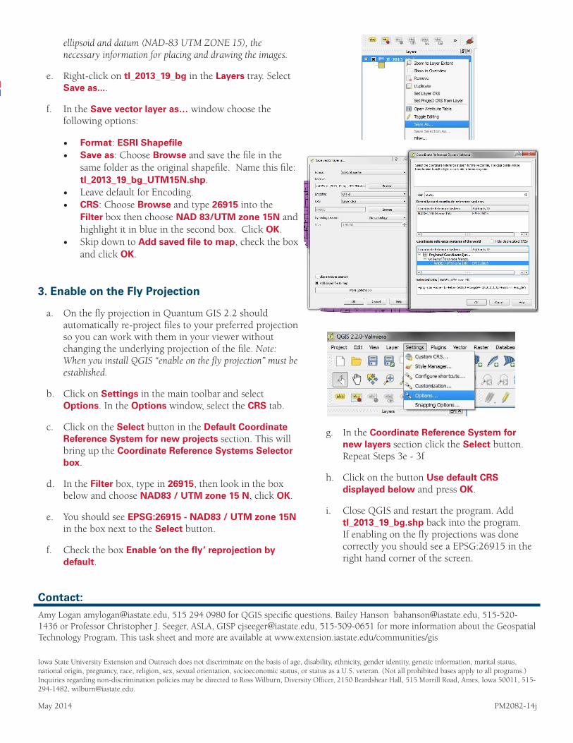
e. Right-click on tl_2013_19_bg in the Layers tray. Select Save as....
f. In the Save vector layer as… window choose the following options:
• Format: ESRI Shapefile• Save as: Choose Browse and save the file in the
same folder as the original shapefile. Name this file: tl_2013_19_bg_UTM15N.shp.
• Leave default for Encoding.• CRS: Choose Browse and type 26915 into the
Filter box then choose NAD 83/UTM zone 15N and highlight it in blue in the second box. Click OK.
• Skip down to Add saved file to map, check the box and click OK.
3. Enable on the Fly Projection
a. On the fly projection in Quantum GIS 2.2 should automatically re-project files to your preferred projection so you can work with them in your viewer without changing the underlying projection of the file. Note: When you install QGIS “enable on the fly projection” must be established.
b. Click on Settings in the main toolbar and select Options. In the Options window, select the CRS tab.
c. Click on the Select button in the Default Coordinate Reference System for new projects section. This will bring up the Coordinate Reference Systems Selector box.
d. In the Filter box, type in 26915, then look in the box below and choose NAD83 / UTM zone 15 N, click OK.
e. You should see EPSG:26915 - NAD83 / UTM zone 15N in the box next to the Select button.
f. Check the box Enable ‘on the fly’ reprojection by default.
g. In the Coordinate Reference System for new layers section click the Select button. Repeat Steps 3e - 3f
h. Click on the button Use default CRS displayed below and press OK.
i. Close QGIS and restart the program. Add tl_2013_19_bg.shp back into the program. If enabling on the fly projections was done correctly you should see a EPSG:26915 in the right hand corner of the screen.