Embed Size (px)
Citation preview

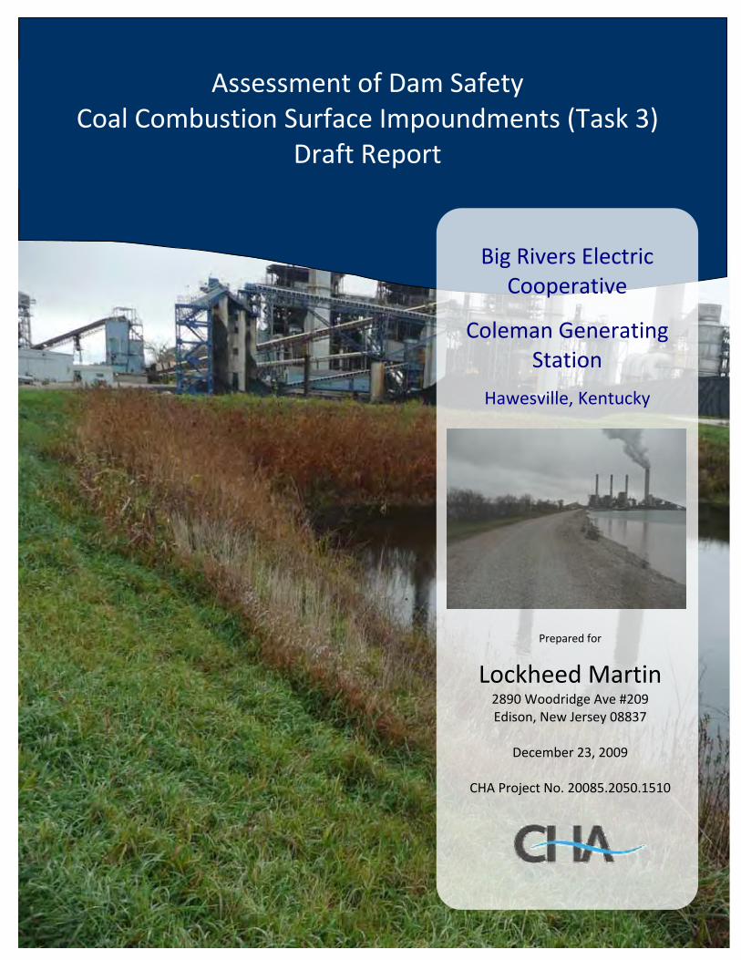
Big Rivers Electric Cooperative
Coleman Generating Station
Hawesville, Kentucky
Prepared for
Lockheed Martin 2890 Woodridge Ave #209 Edison, New Jersey 08837
December 23, 2009
CHA Project No. 20085.2050.1510
Assessment of Dam Safety Coal Combustion Surface Impoundments (Task 3)
Draft Report
-ii- Draft Report Assessment of Dam Safety of
Coal Combustion Surface Impoundments Big Rivers Electric Cooperative
Coleman Generating Station Hawesville, Kentucky
I acknowledge that the management units referenced herein:
Active Ash Pond A Inactive Ash Pond C
Have been assessed on November 17, 2009. Signature: _________________________________________ Malcolm D. Hargraves, P.E. Senior Geotechnical Engineer Signature: _________________________________________ John Sobiech, P.E. Senior Geotechnical Engineer Registered in the State of Kentucky Reviewer: _________________________________________ Warren A. Harris, P.E. Reviewer

-iii- Draft Report Assessment of Dam Safety of
Coal Combustion Surface Impoundments Big Rivers Electric Cooperative
Coleman Generating Station Hawesville, Kentucky
TABLE OF CONTENTS SECTION PAGE NUMBER 1.0 INTRODUCTION & PROJECT DESCRIPTION........................................................ 1
1.1 Introduction..................................................................................................................... 1 1.2 Project Background......................................................................................................... 2
1.2.1 State Issued Permits ................................................................................................ 2 1.3 Site Description and Location......................................................................................... 3
1.3.1 Other Impoundments .............................................................................................. 4 1.4 Previously Identified Safety Issues................................................................................. 5 1.5 Site Geology.................................................................................................................... 5 1.6 Bibliography ................................................................................................................... 5
2.0 FIELD ASSESSMENT................................................................................................... 16
2.1 Visual Observations ...................................................................................................... 16 2.2 Visual Observation - Ash Pond A................................................................................. 17
2.2.1 Ash Pond A - Crests.............................................................................................. 17 2.2.2 Ash Pond A - Embankment Slopes....................................................................... 17 2.2.3 Ash Pond A - Outlet Structures ............................................................................ 19
2.3 Visual Observations - Ash Pond C ............................................................................... 19 2.3.1 Ash Pond C Crest.................................................................................................. 20 2.3.2 Ash Pond C Embankment Slopes ......................................................................... 20 2.3.3 Ash Pond C Outlet Structures ............................................................................... 21
2.4 Monitoring Instrumentation .......................................................................................... 22 3.0 DATA EVALUATION ................................................................................................... 47
3.1 Design Assumptions ..................................................................................................... 47 3.2 Hydrologic and Hydraulic Design ................................................................................ 47
3.2.1 Ash Pond A - Hydrologic and Hydraulic Design ................................................. 47 3.2.2 Ash Pond C - Hydrologic and Hydraulic Design.................................................. 48
3.3 Structural Adequacy & Stability................................................................................... 48 3.4 Foundation Conditions.................................................................................................. 49 3.5 Inspections .................................................................................................................... 49
3.5.1 State Inspections ................................................................................................... 49 3.5.2 Inspections by Engineering Consultants............................................................... 50 3.5.3 Inspections by Plant Personnel ............................................................................. 50
4.0 CONCLUSIONS/RECOMMENDATIONS ................................................................. 52
4.1 Acknowledgement of Management Unit Condition ..................................................... 52 4.2 Ash Pond A and Ash Pond C - Stability Analyses ....................................................... 52 4.3 Ash Pond A and Ash Pond C - Hydrologic and Hydraulic Analysis............................ 53 4.4 Ash Pond A - Freeboard ............................................................................................... 53 4.5 Ash Pond A - Crest Area and Inboard Slope Maintenance .......................................... 53 4.6 Ash Pond A - Instrumentation and Monitoring ............................................................ 54
-iv- Draft Report Assessment of Dam Safety of
Coal Combustion Surface Impoundments Big Rivers Electric Cooperative
Coleman Generating Station Hawesville, Kentucky
TABLE OF CONTENTS - continued SECTION PAGE NUMBER
4.7 Ash Pond A and Ash Pond C - Grass Slope Maintenance............................................ 54 4.8 Ash Pond C - Heavy Vegetation and Tree Control on the South Dike......................... 55 4.9 Ash Pond A - Rodent Control....................................................................................... 55 4.10 Ash Pond A and Ash Pond C - Rock Armament Vegetation Control .......................... 55
5.0 CLOSING ........................................................................................................................ 56
TABLES
Table 1 - Approximate Precipitation Prior to Site Visit ............................................................... 16 Table 2 - Summary of KDEP Inspections of Ash Pond A............................................................ 49 Table 3 - Summary of BREC Monthly Inspections...................................................................... 51
LIST OF FIGURES Figure 1 - Project Location Map..................................................................................................... 7 Figure 2 - Photo Site Map............................................................................................................... 8 Figure 3 - Critical Infrastructure Location Map ............................................................................. 9 Figure 4 - Active Ash Pond A Plan View..................................................................................... 10 Figure 5 - Active Ash Pond A Dike Section at Spillway Riser and Spillway Riser Section........ 11 Figure 6 - Active Ash Pond A Typical Dike Sections .................................................................. 12 Figure 7 - Inactive Ash Pond C Plan View................................................................................... 13 Figure 8 - Inactive Ash Pond C Typical Dike Sections ................................................................ 14 Figure 9 - Plan View of Ash Pond Reclaimed for Beneficial Reuse ............................................ 15 Figure 10A - Photo Location Map................................................................................................ 23 Figure 10B - Photo Location Map ................................................................................................ 24
APPENDIX Appendix A - Completed EPA Coal Combustion Dam Inspection Checklists and Coal
Combustion Waste (CCW) Impoundment Inspection Forms

-1- Draft Report Assessment of Dam Safety of
Coal Combustion Surface Impoundments Big Rivers Electric Cooperative
Coleman Generating Station Hawesville, Kentucky
1.0 INTRODUCTION & PROJECT DESCRIPTION
1.1 Introduction
CHA was contracted by Lockheed Martin (a contractor to the United States Environmental
Protection Agency) to perform site assessments of selected coal combustion surface
impoundments (Project #0-381 Coal Combustion Surface Impoundments/Dam Safety
Inspections). As part of this contract, CHA was assigned to perform a site assessment of Big
Rivers Electric Cooperative’s Coleman Generating Station, which is located in Hawesville,
Kentucky as shown on Figure 1 – Project Location Map. Big Rivers Electric Cooperative
(BREC) resumed operational control of the Coleman Generating Station from Western Kentucky
Energy Corporation, an E.On US subsidiary, in July 2009.
CHA made a site visit on November 17, 2009 to inventory coal combustion surface
impoundments at the Coleman facility, to perform visual observations of the containment dikes,
and to collect relevant information regarding the site assessment.
CHA Engineers John Sobiech, P.E. and Malcolm Hargraves, P.E. were accompanied by the
following individuals:
Company or Organization Name Name KY DEP – Division of Water/Dam Safety Scott Phelps, P.E., Supervisor US EPA Jim Kohler, P.E., Environmental Engineer Associated Engineers, Inc. David Lamb, P.E. President Big Rivers Electric Cooperative Tom Shaw, Manager – Environmental Services Big Rivers Electric Cooperative Daryl Citimn, Manager - Maintenance Big Rivers Electric Cooperative Mike Jones, Material Handling Supervisor Big Rivers Electric Cooperative Wayne O’Bryan, Manager – Production Services
-2- Draft Report Assessment of Dam Safety of
Coal Combustion Surface Impoundments Big Rivers Electric Cooperative
Coleman Generating Station Hawesville, Kentucky
1.2 Project Background
A total of four separate ponds have been present at one time or another at the Coleman
Generation Station. Three of these ponds have been on the immediate property of the steam
generation facility, and another one is on separate property acquired within about a mile
downstream of the present facility along the Ohio River for the purpose of constructing the new
pond. Active Ash Pond A, also referred to in some documents as the Active Recirculation Ash
Pond, a reclaimed pond formerly known as the North Ash Pond, and Inactive Ash Pond C, also
referred to in some documents as the South Ash Pond, are located on the immediate grounds of
the generation facility. The New Ash Pond, also referred to as the Wastewater Treatment
Facility, is the pond located remotely on the downstream property. It has not been completed
and construction on the impoundment has been suspended since late 2008. Only two of the four
ponds, Active Ash Pond A (hereafter called Ash Pond A) and Inactive Ash Pond C (hereafter
called Ash Pond C) receive sluiced ash or dredged sluiced ash for dewatering purposes. The
reclaimed pond cannot receive a waste product because it has been converted into an exterior
storage and parking area and an approval to impound has not been issued for the New Ash Pond.
Only Ash Pond A is under Kentucky Department of Environmental Protection (DEP) – Division
of Water regulation. It has been given ID No. 0842 in the Kentucky State Dam inventory system
and has been given a moderate hazard rating in the Kentucky DEP system on the basis of
significant damage to property and facility operation should the impoundment fail.
1.2.1 State Issued Permits
Commonwealth of Kentucky Permit No. KY0001937 has been issued to Kentucky Utilities
authorizing discharge under the National Pollutant Discharge Elimination System (NPDES) to
the Ohio River in accordance with effluent limitations, monitoring requirements and other
conditions set forth in the permit. The permit became effective on February 26, 2001 and was
set to expire on February 28, 2005. According to BREC personnel, the renewal application was
submitted in a timely fashion and is currently under review. It is unknown when a new permit

-3- Draft Report Assessment of Dam Safety of
Coal Combustion Surface Impoundments Big Rivers Electric Cooperative
Coleman Generating Station Hawesville, Kentucky
will be issued, so BREC continues to operate under the conditions of the expired permit until KY
DEP issues an updated permit.
1.3 Site Description and Location
Figure 2 – Photo Site Plan shows the location of the three management units that have at one
time or another received sluiced ash or dredged ash for dewatering for the Coleman Generating
Station. Ash Pond A is located immediately north of the coal pile and generation plant. The
reclaimed North Ash Pond area is located to the west of the generation plant. Its north dike is the
southern half of the dike forming the south dike forming the adjacent Ash Pond A. Ash Pond C
positioned at the southern extremity of the main plant facility and shares part of its north dike
with the reclaimed North Ash Pond. River Road bounds the western extremity of the facility and
the Ohio River bounds the eastern edge of Ash Pond A and generation facility.
Ash Pond A was completed in 1980. Figures 4, 5, 6A and 6B show the design plan area and
typical dike cross sections when it was completed. Ash Pond A covers an area of about 48 acres
with a maximum height of 30 feet. Based upon the plans, the dikes forming this pond were
constructed with 2.5 horizontal (H):1 vertical (V) inboard and outboard slopes, with rock toe
armoring along the east dike facing the Ohio River and rock slope facing in the area of an
emergency spillway on its north dike. Steeper 2H:1V outboard slopes were constructed in the
western portion of the south dike built as a raising of an existing dike of an older basin. It
currently receives sluiced fly ash and bottom ash. One important item not shown explicitly on
the aforementioned site plan is the recirculation pump structure, though a plan note does indicate
the area on the impoundment dike where this structure is to be constructed.
Ash Pond C was completed when the plant was originally constructed in 1971. Figures 7 and 8
show the plan area from a 1990 survey of this pond and typical cross sections of the dikes as they
were designed in 1967. It presently covers an area of roughly 90 acres, has a maximum height of
15 feet and stores bottom ash and fly ash. Based upon the plans, the dikes forming this pond
-4- Draft Report Assessment of Dam Safety of
Coal Combustion Surface Impoundments Big Rivers Electric Cooperative
Coleman Generating Station Hawesville, Kentucky
were constructed with 2H:1V inboard and outboard slopes. Ash Pond C is currently inactive and
no longer receives sluiced ash. It is generally dry and has a stand of grass and weedy vegetation
over most of its area, but is still maintained as a pond receiving dredged ash removed from Ash
Pond A for dewatering and eventual reuse or landfilling
The North Pond was constructed when Ash Pond C and the present facility was completed in
1971. Based upon the available plans, this pond has a surface area of approximately 21 acres
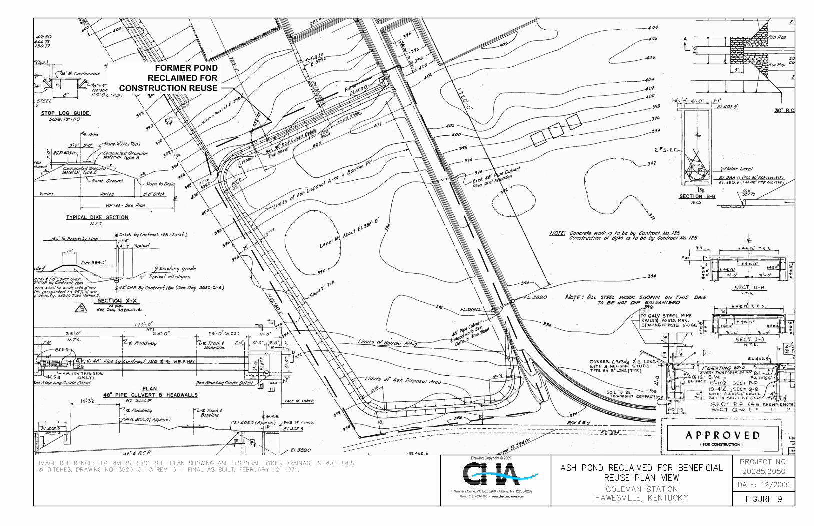
and was about 17 to 18 feet in height. In 2002, a Registered Permit-by-Rule for Beneficial
Reuse of Special Waste No. 046-00022 was accepted to close, regrade, and reclaim the pond to
use initially as a construction lay down area during the scrubber construction, then convert the
area to external storage and parking. Figure 9 shows the plan area of the North Pond when it was
constructed, prior to the time the pond was reclaimed.
An aerial photograph of the region indicating the location of the Coleman Generating Plant
facilities and identifying schools, hospitals, or other critical infrastructure located within
approximately five miles down gradient of Ash Pond A and Ash Pond C. is provided as Figure 3.
1.3.1 Other Impoundments
There is one other impoundment called the New Ash Pond, also referred to as the Wastewater
Treatment Facility, located remotely on property BREC had obtained downstream of the present
facility. Construction on this pond began in 2007 and has been temporarily suspended since late
2008, leaving the dikes approximately 12 feet below their design crest elevation. According to
Kentucky DEP personnel and CREC personnel, a permit to impound, which would allow the
sluicing of Coal Combustion Byproducts (CCB) to commence, has not been issued for this basin.
Consequentially, the basin has not been used to store sluiced ash. During previous inspections at
this basin, severe erosion as a result of poorly established grass cover on the slopes during the
construction shut down period was observed. In order to preserve the slopes and save the
-5- Draft Report Assessment of Dam Safety of
Coal Combustion Surface Impoundments Big Rivers Electric Cooperative
Coleman Generating Station Hawesville, Kentucky
embankment soil, BREC has started placing compacted gypsum and ash on the inboard slopes.
This activity was occurring at the time CHA visited the site
1.4 Previously Identified Safety Issues
Based on our review of the information provided to CHA and as reported by BREC, there have
been no identified safety issues at Ash Pond A or Ash Pond C in the last 10 years.
1.5 Site Geology
The Geologic map of Kentucky, prepared by R.C. McDowell et al. in 1981 for the U.S.
Geological Survey, indicates that the ash ponds and generation facility lie above Holocene aged
Ohio River deposited alluvium of the Quarternary period. This alluvium most likely lies above
bedrock of the Pennsylvanian period comprising interbedded siltstone and sandstone, with
tertiary amounts of limestone and coal mapped as the Tradewater formation.
1.6 Bibliography
CHA reviewed the following documents provided by BREC in preparing this report:
• Big Rivers RECC KY. 62 – Big Rivers Kenneth C. Coleman Power Plant Site Plan,
February 12, 1971, with Revisions, Parson-Jurden Corporation Engineers and
Constructors
• Big Rivers Electric Corporation Site Coleman Power Plant Selected Record Drawings,
May 31, 979 with Revisions, Burns and Roe, Inc. Engineers and Constructors
• Certificate of Inspection for Dam and Appurtenant Works, Various Reports dated
October 2004, April 2006, and April 2009, Kentucky Department for Environmental
Protection – Division of Water.

-6- Draft Report Assessment of Dam Safety of
Coal Combustion Surface Impoundments Big Rivers Electric Cooperative
Coleman Generating Station Hawesville, Kentucky
• Dam Inspection Reports, Reports from May 2008 and February 2009, Big Rivers
Electrical Cooperative
• Impoundment Inspection Report, Monthly Reports from May through October 2009, Big
Rivers Electrical Cooperative
• Coleman Impoundment Inspection Report, April 2009, Associated Engineers, Inc.
• Impoundment Inspection Report, June 2009, Associated Engineers, Inc.
• Meeting on Dam Inspection Action Items, November Meeting Minutes, Big Rivers
Electrical Cooperative

Figure 1 Project Location Map
Western Kentucky Energy Coleman Station Hawesville, KY
Scale: 1" = 1 mile Project No.: 20085.2050.1510
Coleman Station
IMAGE DATE: 07/01/1991
FLOW
FLOW
COLEMAN STATION
OHIO RIVER
OUTFALL ELEVATIONFOR ACTIVE POND A
EMBANKMENT CROSSSECTION AT ACTIVE
POND A OUTFALL
INACTIVE POND C

CROSS SECTION ATINACTIVE POND C
NORTH DIKE CROSSSECTION AT INACTIVE
POND C
-16- Draft Report Assessment of Dam Safety of
Coal Combustion Surface Impoundments Big Rivers Electric Cooperative
Coleman Generating Station Hawesville, Kentucky
2.0 FIELD ASSESSMENT
2.1 Visual Observations
CHA performed visual observations of the Ash Pond A and Ash Pond C dikes following the
general procedures and considerations contained in Federal Emergency Management Agency’s
(FEMA’s) Federal Guidelines for Dam Safety (April 2004), and Federal Energy Regulatory
Commission (FERC) Part 12 Subpart D to make observations concerning settlement, movement,
erosion, seepage, leakage, cracking, and deterioration. A Coal Combustion Dam Inspection
Checklist and Coal Combustion Waste (CCW) Impoundment Inspection Form, prepared by the
US Environmental Protection Agency, were completed on-site during the site visit. Copies of
the completed forms were submitted via email to a Lockheed Martin representative
approximately three days following the site visit to the Coleman Generating Station. Copies of
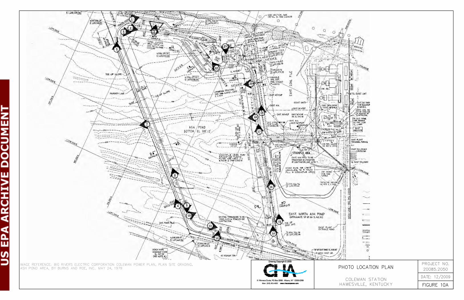
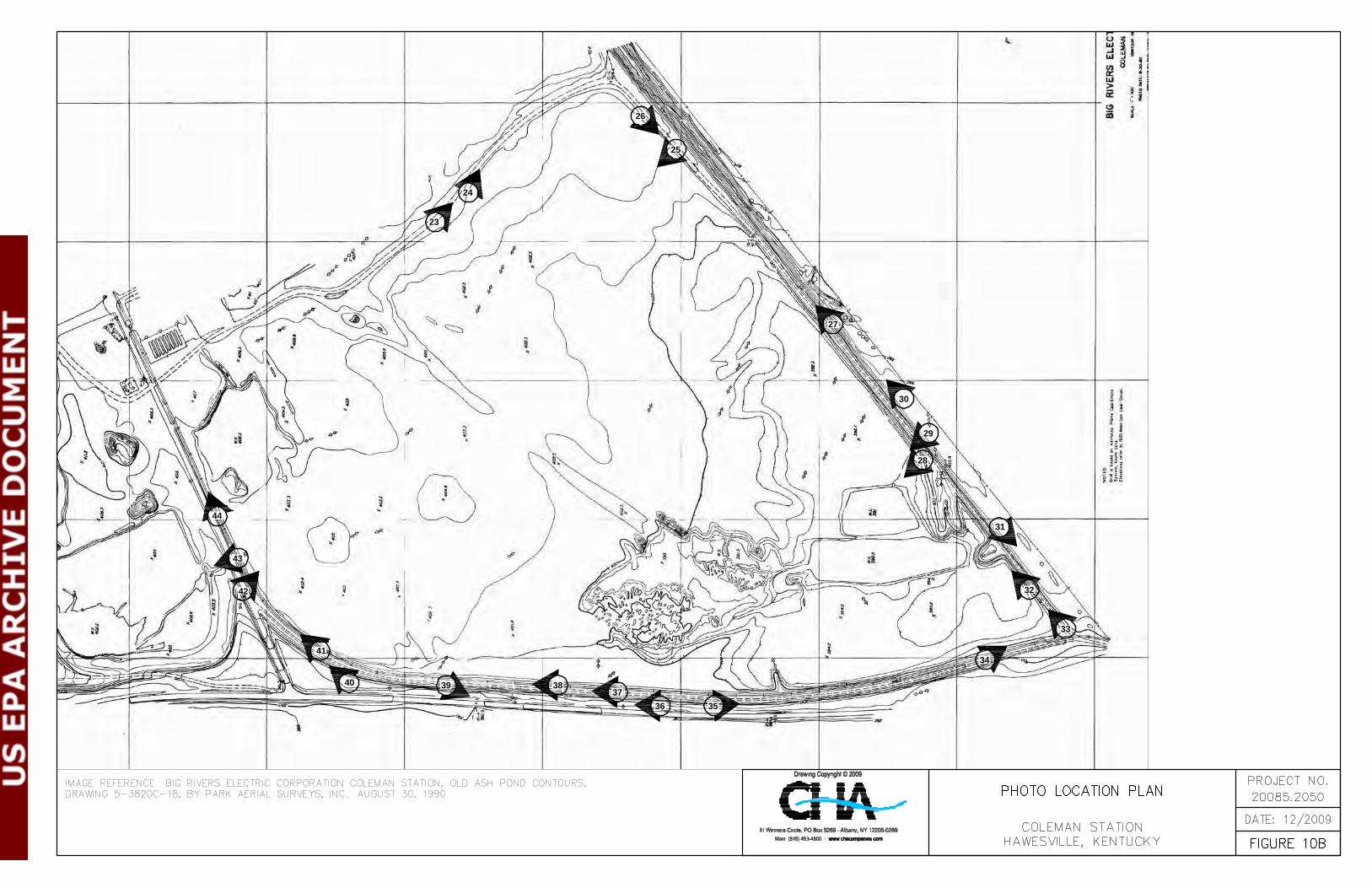
these completed forms are included in Appendix A. A photo log and Site Photo Location Maps
(Figures 10A and 10B) are also located at the end of Section 2.5.3.
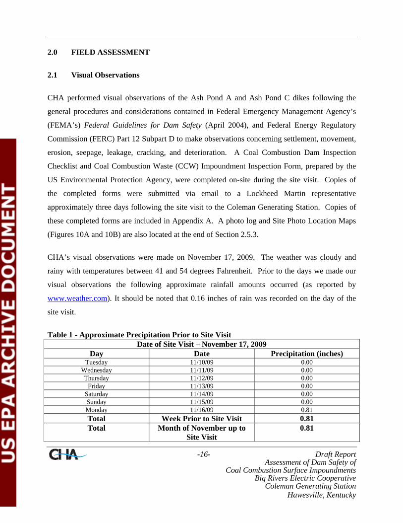
CHA’s visual observations were made on November 17, 2009. The weather was cloudy and
rainy with temperatures between 41 and 54 degrees Fahrenheit. Prior to the days we made our
visual observations the following approximate rainfall amounts occurred (as reported by
www.weather.com). It should be noted that 0.16 inches of rain was recorded on the day of the
site visit.
Table 1 - Approximate Precipitation Prior to Site Visit Date of Site Visit – November 17, 2009
Day Date Precipitation (inches) Tuesday 11/10/09 0.00
Wednesday 11/11/09 0.00 Thursday 11/12/09 0.00
Friday 11/13/09 0.00 Saturday 11/14/09 0.00 Sunday 11/15/09 0.00 Monday 11/16/09 0.81 Total Week Prior to Site Visit 0.81 Total Month of November up to
Site Visit 0.81

-17- Draft Report Assessment of Dam Safety of
Coal Combustion Surface Impoundments Big Rivers Electric Cooperative
Coleman Generating Station Hawesville, Kentucky
2.2 Visual Observation – Ash Pond A
CHA performed visual observations of the primary dike, which is about 5,900 feet long and
about 30 feet high.
2.2.1 Ash Pond A - Crests
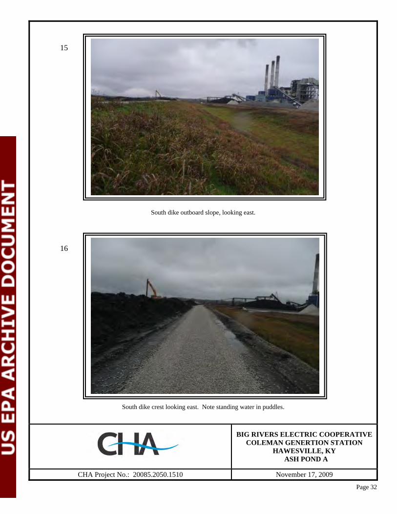
In general, the Ash Pond A dikes do not show signs of changes in horizontal alignment from the
designed alignment (Photos 2, 8, 13, 14) The crest areas supported a granular surfaced access
drive to service the impoundment. Theses appeared stable and free from any abrupt gross
vertical deformation or cracking. In some areas the embankment crest areas were overbuilt due
to ash handling processes, and a build-up of ash could be observed, making the crest area wider
than initially designed (Photo 14). This was particularly evident along the western and central
portions of the south dike, and to a somewhat lesser extent along the west dike and the western
portion of the north dike. Isolated areas of softened surface gravel and bird baths were also
observed on the south dike crest as well.(Photo 16).
2.2.2 Ash Pond A – Embankment Slopes
The outboard slopes were uniformly graded and generally covered with grassy vegetation from
the crest to the toe elevation (Photos 6, 11, and 15). These areas generally appeared to be well
maintained and stable with no readily observable sloughs, scarps, bulges, or other large
deformations that would indicate global instability.
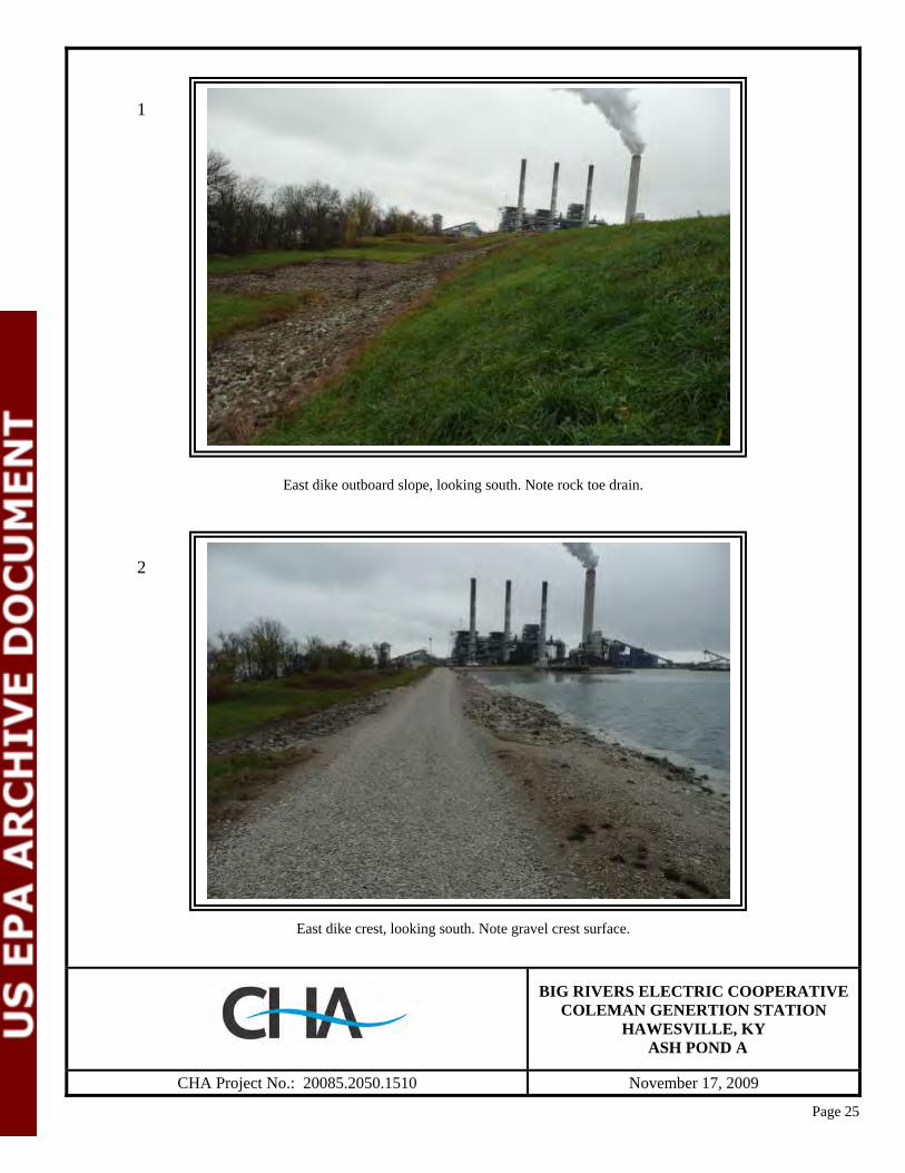
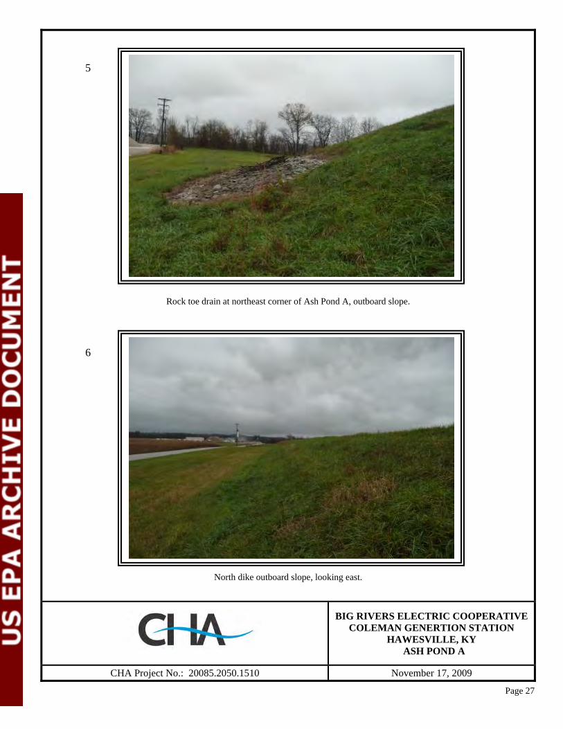
A rock armored toe to approximately ¼ of the slope height was evident on the east dike (Photo
1). This rock toe armoring appeared to be reasonably maintained, with sporadic fouling
vegetative growth (Photo 5). It appears as if this armoring was designed and placed at this
location as a measure of protecting the toe should a major flood event occur on the Ohio River
that runs parallel to the dike. The east dike also has a portion of its length upon which rock

-18- Draft Report Assessment of Dam Safety of
Coal Combustion Surface Impoundments Big Rivers Electric Cooperative
Coleman Generating Station Hawesville, Kentucky
armoring was observed from the crest to the toe. This is the area of the emergency spillway
(Photo 3).
An access ramp for ash processing equipment and pond maintenance was observed on the south
dike outboard slope. Ash sluicing lines and other waste water pipelines emptying into the pond
were also noted on this ramp. In the portion of the dike north of this access ramp, standing water
was observed at the dike toe in a drainage swale. This appeared to be due to precipitation before
and during the site visit in addition to possible poor drainage (Photo 19).
Standing water was also observed at the toe area of the north dike. In this area however, in
addition to the recent precipitation, the standing water was the consequence of a drainage culvert
beneath an access drive being crushed and completely covered (Photo 7). This has blocked the
culvert and apparently allowed standing water to build up in this area for a period of time. In this
area the soil at the base of the drainage swale had begun to soften, allowing a probe to penetrate
approximately 1 foot.
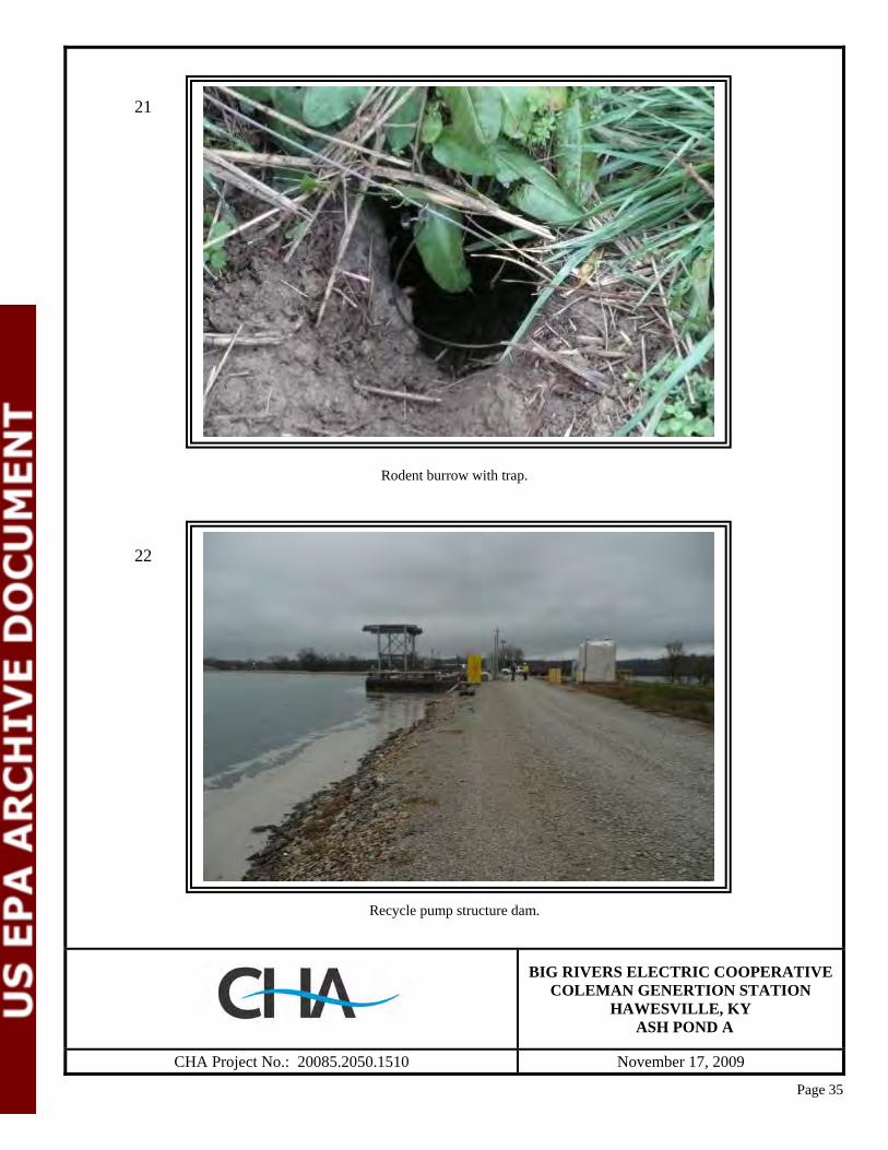
Other observations of note on the outboard slope areas were isolated rodent burrows on the east
and north dike slopes and grassed shallow ruts on the west and north slopes. One of the
encountered rodent burrows had been rigged with a wire loop trap, indicating that the facility is
actively attempting rodent control (Photo 21). The shallow grassed ruts are most likely related to
mowing activities in steeper areas of the slope with tractor machinery when the slopes may have
been wet (Photo 12).
Inboard slope areas of the impoundment were generally rock or ash covered (Photos 4, 9, 13, 14,
and 17). As a result of grading activities, looser materials had been pushed out on these slopes,
making them susceptible to erosion rills in locations where surface runoff has become
concentrated (Photos 10 and 18). These areas were also susceptible to beaching erosion,
particularly in the western portion of pond. Available freeboard appears to be on the order 1.5 to
-19- Draft Report Assessment of Dam Safety of
Coal Combustion Surface Impoundments Big Rivers Electric Cooperative
Coleman Generating Station Hawesville, Kentucky
2 feet on the western end of the north dike and about 2 to 3 feet on the east dike, potentially
enhancing the effect of beaching erosion and other wave action from the open pond area.
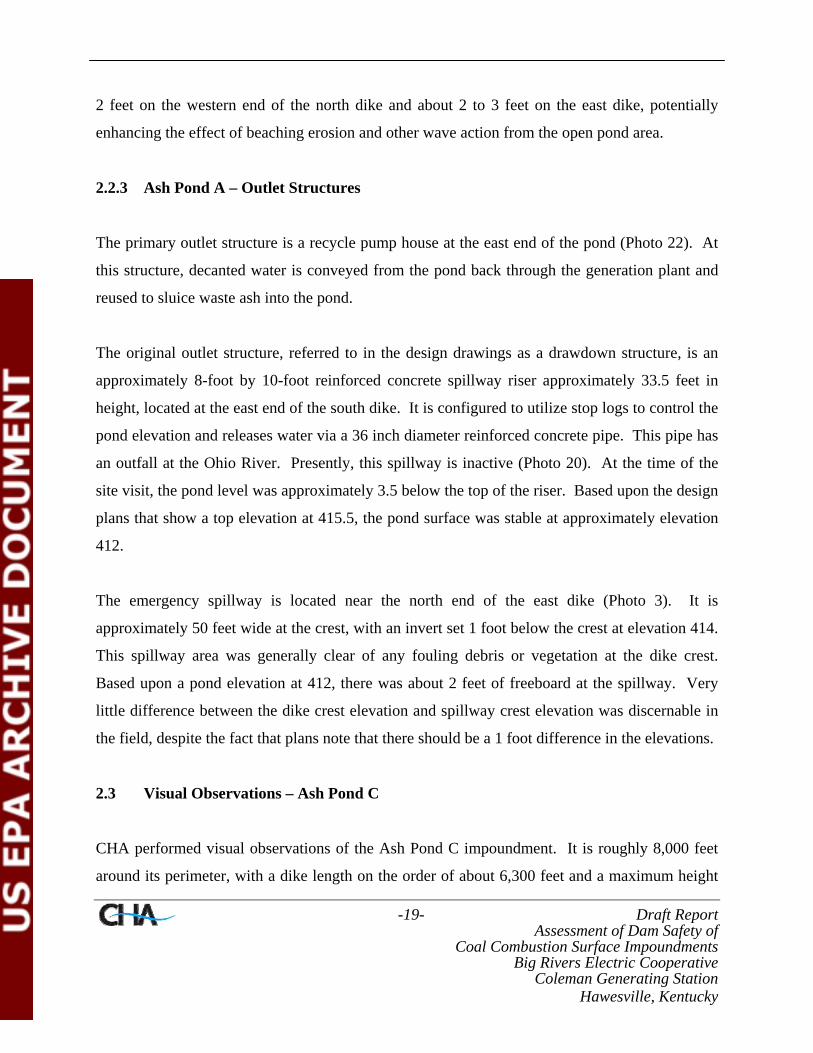
2.2.3 Ash Pond A – Outlet Structures
The primary outlet structure is a recycle pump house at the east end of the pond (Photo 22). At
this structure, decanted water is conveyed from the pond back through the generation plant and
reused to sluice waste ash into the pond.
The original outlet structure, referred to in the design drawings as a drawdown structure, is an
approximately 8-foot by 10-foot reinforced concrete spillway riser approximately 33.5 feet in
height, located at the east end of the south dike. It is configured to utilize stop logs to control the
pond elevation and releases water via a 36 inch diameter reinforced concrete pipe. This pipe has
an outfall at the Ohio River. Presently, this spillway is inactive (Photo 20). At the time of the
site visit, the pond level was approximately 3.5 below the top of the riser. Based upon the design
plans that show a top elevation at 415.5, the pond surface was stable at approximately elevation
412.
The emergency spillway is located near the north end of the east dike (Photo 3). It is
approximately 50 feet wide at the crest, with an invert set 1 foot below the crest at elevation 414.
This spillway area was generally clear of any fouling debris or vegetation at the dike crest.
Based upon a pond elevation at 412, there was about 2 feet of freeboard at the spillway. Very
little difference between the dike crest elevation and spillway crest elevation was discernable in
the field, despite the fact that plans note that there should be a 1 foot difference in the elevations.
2.3 Visual Observations – Ash Pond C
CHA performed visual observations of the Ash Pond C impoundment. It is roughly 8,000 feet
around its perimeter, with a dike length on the order of about 6,300 feet and a maximum height
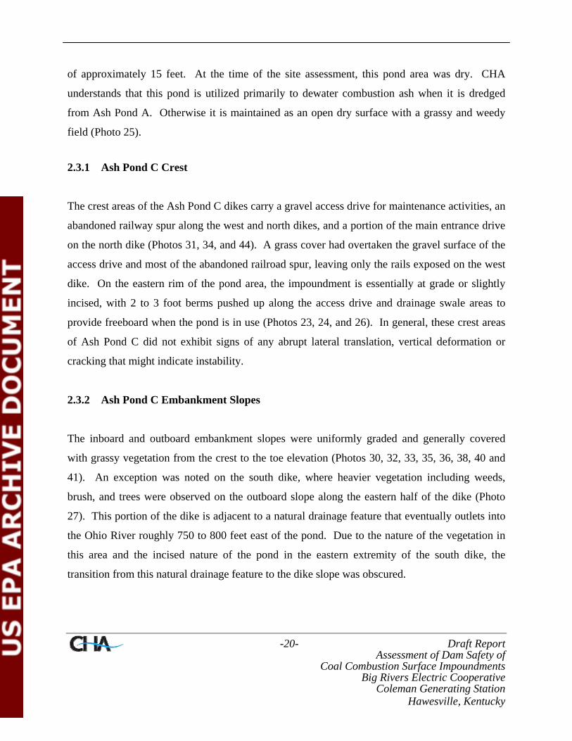
-20- Draft Report Assessment of Dam Safety of
Coal Combustion Surface Impoundments Big Rivers Electric Cooperative
Coleman Generating Station Hawesville, Kentucky
of approximately 15 feet. At the time of the site assessment, this pond area was dry. CHA
understands that this pond is utilized primarily to dewater combustion ash when it is dredged
from Ash Pond A. Otherwise it is maintained as an open dry surface with a grassy and weedy
field (Photo 25).
2.3.1 Ash Pond C Crest
The crest areas of the Ash Pond C dikes carry a gravel access drive for maintenance activities, an
abandoned railway spur along the west and north dikes, and a portion of the main entrance drive
on the north dike (Photos 31, 34, and 44). A grass cover had overtaken the gravel surface of the
access drive and most of the abandoned railroad spur, leaving only the rails exposed on the west
dike. On the eastern rim of the pond area, the impoundment is essentially at grade or slightly
incised, with 2 to 3 foot berms pushed up along the access drive and drainage swale areas to
provide freeboard when the pond is in use (Photos 23, 24, and 26). In general, these crest areas
of Ash Pond C did not exhibit signs of any abrupt lateral translation, vertical deformation or
cracking that might indicate instability.
2.3.2 Ash Pond C Embankment Slopes
The inboard and outboard embankment slopes were uniformly graded and generally covered
with grassy vegetation from the crest to the toe elevation (Photos 30, 32, 33, 35, 36, 38, 40 and
41). An exception was noted on the south dike, where heavier vegetation including weeds,
brush, and trees were observed on the outboard slope along the eastern half of the dike (Photo
27). This portion of the dike is adjacent to a natural drainage feature that eventually outlets into
the Ohio River roughly 750 to 800 feet east of the pond. Due to the nature of the vegetation in
this area and the incised nature of the pond in the eastern extremity of the south dike, the
transition from this natural drainage feature to the dike slope was obscured.

-21- Draft Report Assessment of Dam Safety of
Coal Combustion Surface Impoundments Big Rivers Electric Cooperative
Coleman Generating Station Hawesville, Kentucky
In general, the inboard and outboard embankment slopes were stable with no readily observable
sloughs, scarps, bulges, or other large deformations that would indicate global instability.
Isolated erosion rills as well as isolated grass cover loss or thinning and slope surface
deformation was observed along the west dike (Photo 39). The erosion rills were generally
grassed over, implying a long, slow development period, while the thinning grass cover and
surface deformation appear to be the result of mowing in previously existing ruts on steeper
portions of the slope. It is likely that previous mowing activities when the slope has been
softened after precipitation events exacerbated the deformation and rutting.
2.3.3 Ash Pond C Outlet Structures
The primary outlet structure is a 24-inch diameter PVC riser connected to a 24-inch diameter
PVC pipe located along the south dike (Photo 28). This pipe conveys water beyond the dike toe
to the upper portions of the drainage feature running parallel to the south dike, eventually
emptying into the Ohio River. At the time of the site assessment, the pond was dry and the outlet
was inactive. It appeared to be open and unobstructed, with rip rap outlet protection. Sporadic
dead or dying vegetation was observed in the outlet protection (Photo 29).
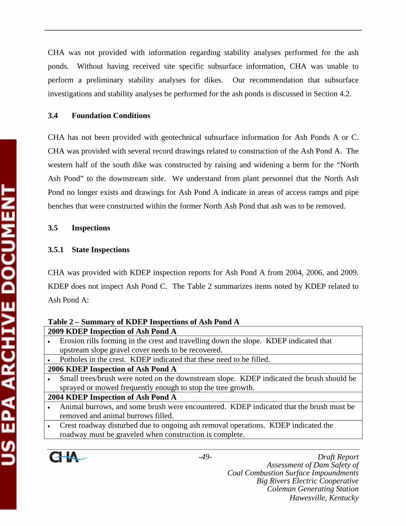
A secondary outlet is a roughly 9-foot by 12-foot reinforced concrete spillway riser located on
the north dike (Photo 42). This structure is connected to a 48-inch diameter reinforced pipe and
conveys water to a sump pit in the area where the old North Ash Pond was reclaimed (Photo 43).
Effluent collected in this sump is pumped to Ash Pond A. This structure is configured to accept
stop logs to control the pond level; however this structure is longer actively controlling a water
level. During the site visit, the ash level and dried ground surface was generally observed to be
above this structure. Furthermore, this area had been graded so that drainage swales from the
pond area could convey water to this location when dredged ash was being dewatered and
promote positive drainage for stormwater runoff. Water was noted pooling against this structure
and dead or dying weedy vegetation was encountered at the structure opening. This vegetation
did not appear to be impeding the structure in its present function.

-22- Draft Report Assessment of Dam Safety of
Coal Combustion Surface Impoundments Big Rivers Electric Cooperative
Coleman Generating Station Hawesville, Kentucky
2.4 Monitoring Instrumentation
CHA is not aware of any installed embankment performance instrumentation at Ash Pond A or
Ash Pond C.
1112
13
10
96
8
7
14
15
16
17
1819
20
21
22
32
1
4
5
40
41
44
43
42
23
24
26
25
30
27
29
28
31
32
33
34
353637
3839
Page 25
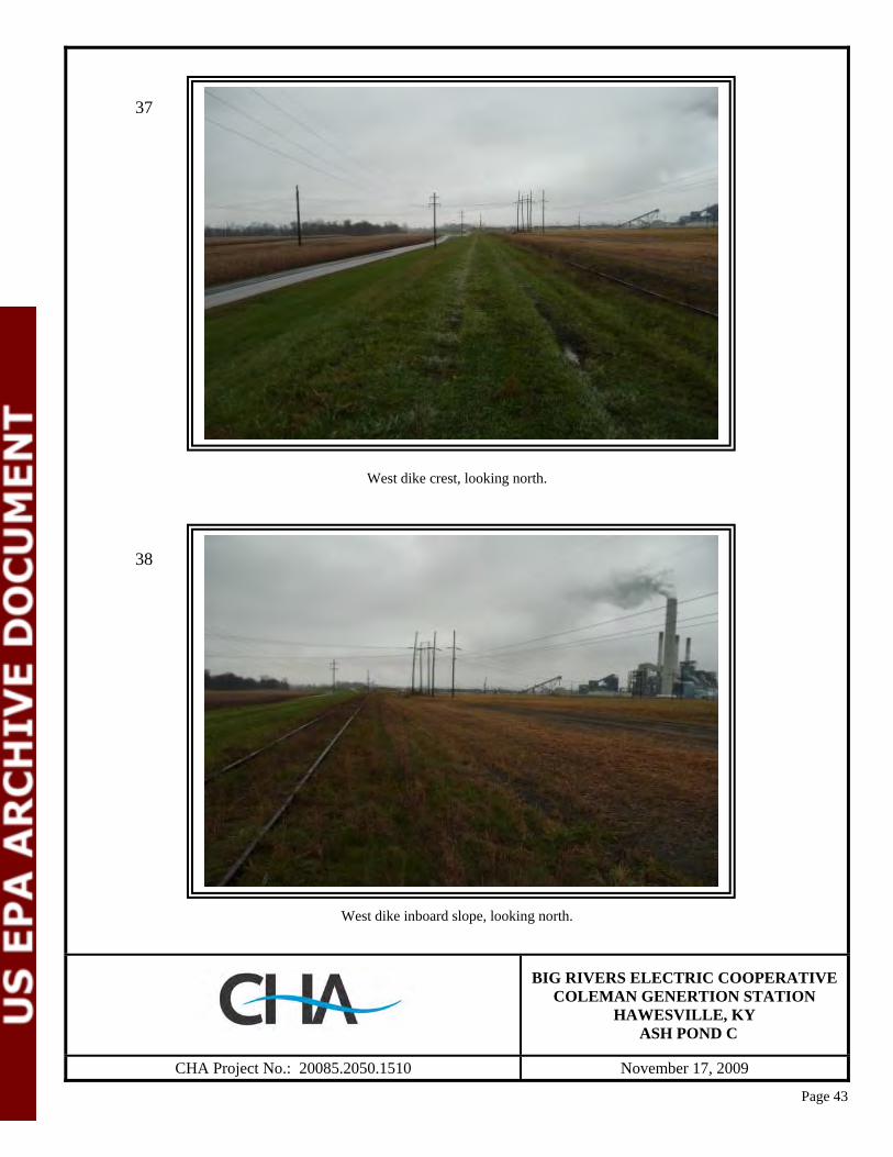
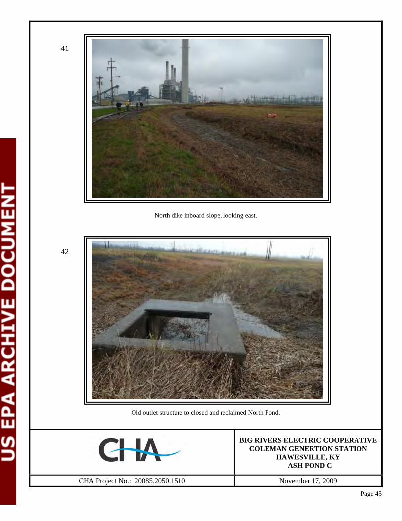
East dike outboard slope, looking south. Note rock toe drain.
East dike crest, looking south. Note gravel crest surface.
BIG RIVERS ELECTRIC COOPERATIVE
COLEMAN GENERTION STATION HAWESVILLE, KY
ASH POND A
CHA Project No.: 20085.2050.1510 November 17, 2009
1
2
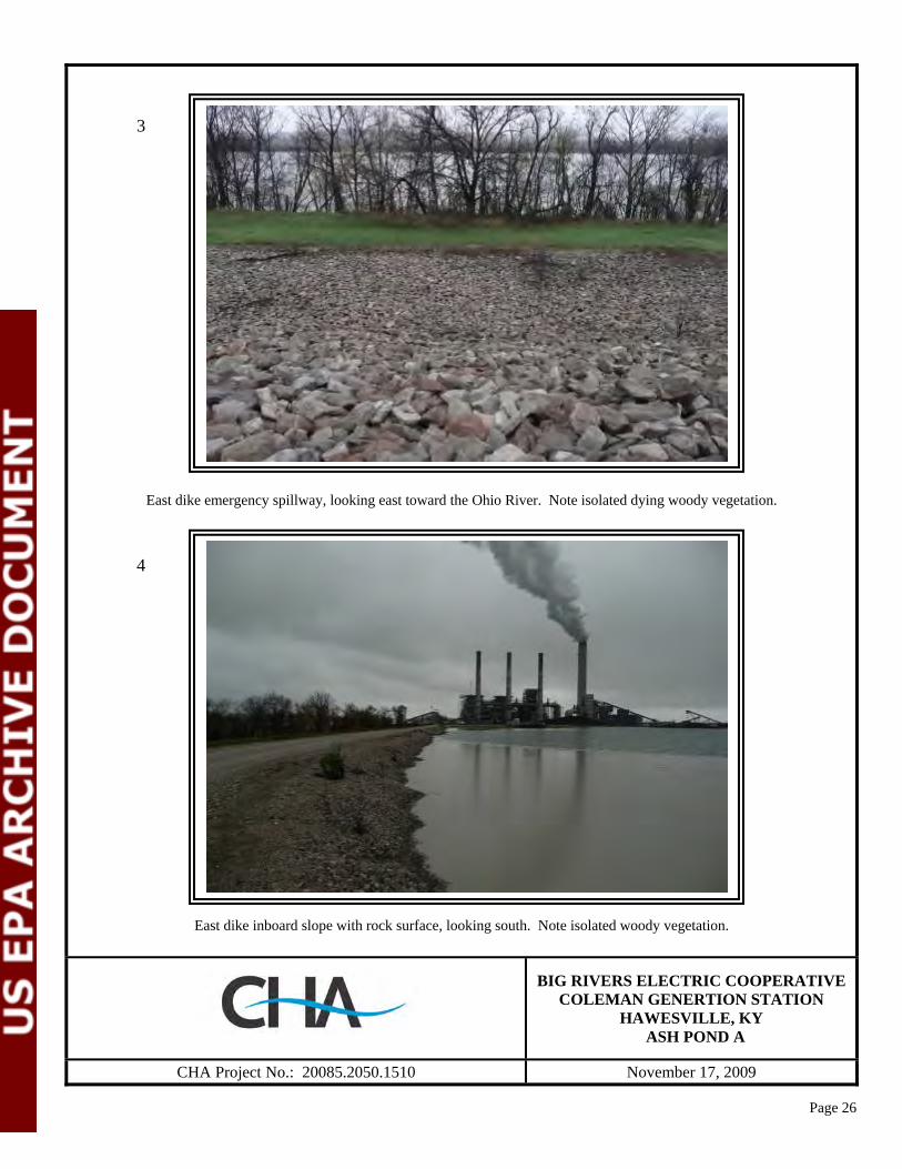
Page 26
East dike emergency spillway, looking east toward the Ohio River. Note isolated dying woody vegetation.
East dike inboard slope with rock surface, looking south. Note isolated woody vegetation.
BIG RIVERS ELECTRIC COOPERATIVE
COLEMAN GENERTION STATION HAWESVILLE, KY
ASH POND A
CHA Project No.: 20085.2050.1510 November 17, 2009
3
4
Page 27
Rock toe drain at northeast corner of Ash Pond A, outboard slope.
North dike outboard slope, looking east.
BIG RIVERS ELECTRIC COOPERATIVE
COLEMAN GENERTION STATION HAWESVILLE, KY
ASH POND A
CHA Project No.: 20085.2050.1510 November 17, 2009
5
6

Page 28
Poor drainage at toe of north dike where culvert under road has been blocked.
North dike crest looking east. Note wet area at toe of dike to left of photo.
BIG RIVERS ELECTRIC COOPERATIVE
COLEMAN GENERTION STATION HAWESVILLE, KY
ASH POND A
CHA Project No.: 20085.2050.1510 November 17, 2009
7
8

Page 29
North dike inboard slope. Note beaching erosion and erosion rills.
Close up of slight beaching on inboard slope of north dike.
BIG RIVERS ELECTRIC COOPERATIVE
COLEMAN GENERTION STATION HAWESVILLE, KY
ASH POND A
CHA Project No.: 20085.2050.1510 November 17, 2009
9
10

Page 30
West dike outboard slope, looking south.
Mowing ruts on west dike outboard slope.
BIG RIVERS ELECTRIC COOPERATIVE
COLEMAN GENERTION STATION HAWESVILLE, KY
ASH POND A
CHA Project No.: 20085.2050.1510 November 17, 2009
11
12
Page 31
West dike inboard slope and crest, looking south.
South dike inboard slope and crest at ash processing area, looking east. Note buildup of ash on inboard slope that widens crest area.
BIG RIVERS ELECTRIC COOPERATIVE
COLEMAN GENERTION STATION HAWESVILLE, KY
ASH POND A
CHA Project No.: 20085.2050.1510 November 17, 2009
13
14
Page 32
South dike outboard slope, looking east.
South dike crest looking east. Note standing water in puddles.
BIG RIVERS ELECTRIC COOPERATIVE
COLEMAN GENERTION STATION HAWESVILLE, KY
ASH POND A
CHA Project No.: 20085.2050.1510 November 17, 2009
15
16

Page 33
South dike, inboard slope looking east at open pond beyond ash processing area.
Erosion rills on inboard slope of south dike.
BIG RIVERS ELECTRIC COOPERATIVE
COLEMAN GENERTION STATION HAWESVILLE, KY
ASH POND A
CHA Project No.: 20085.2050.1510 November 17, 2009
17
18

Page 34
Standing water in drainage swale at toe of south dike.
Concrete outfall structure.
BIG RIVERS ELECTRIC COOPERATIVE
COLEMAN GENERTION STATION HAWESVILLE, KY
ASH POND A
CHA Project No.: 20085.2050.1510 November 17, 2009
19
20
Page 35
Rodent burrow with trap.
Recycle pump structure dam.
BIG RIVERS ELECTRIC COOPERATIVE
COLEMAN GENERTION STATION HAWESVILLE, KY
ASH POND A
CHA Project No.: 20085.2050.1510 November 17, 2009
21
22
Page 36
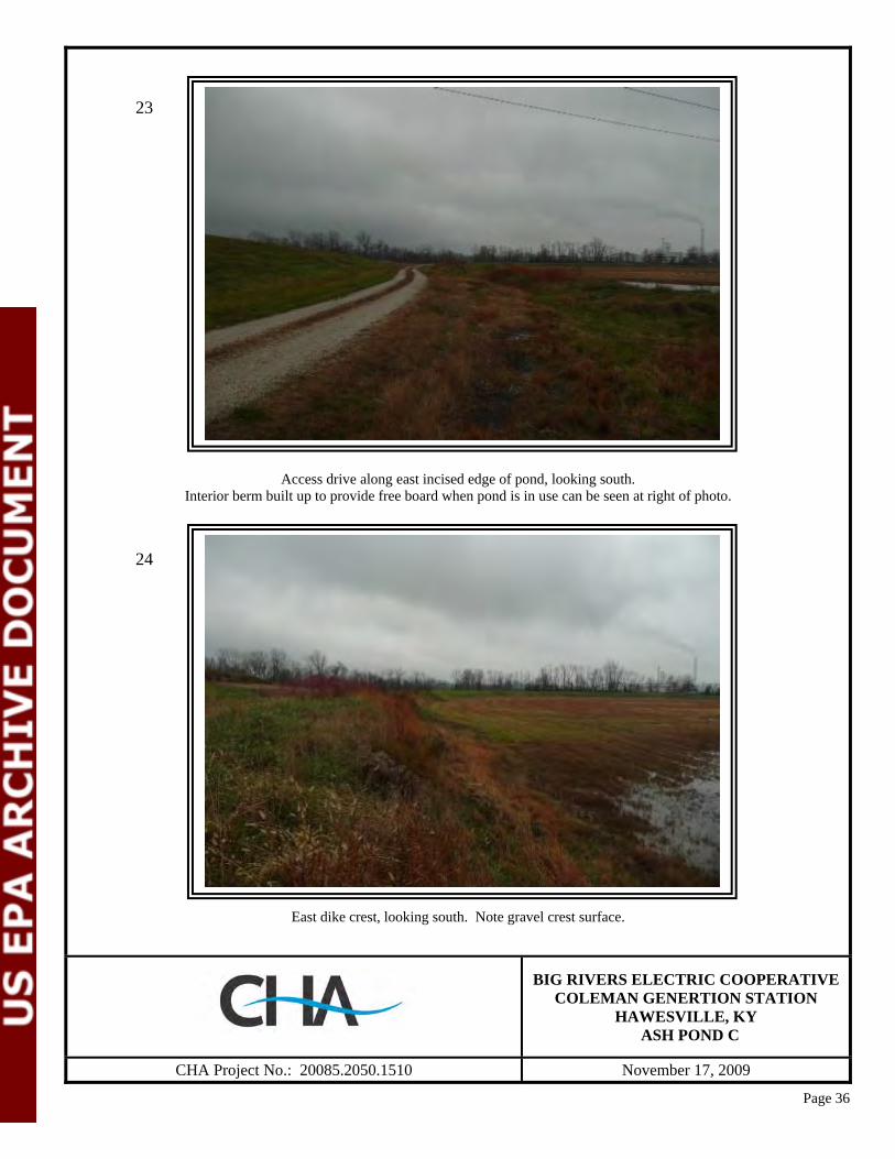
Access drive along east incised edge of pond, looking south. Interior berm built up to provide free board when pond is in use can be seen at right of photo.
East dike crest, looking south. Note gravel crest surface.
BIG RIVERS ELECTRIC COOPERATIVE
COLEMAN GENERTION STATION HAWESVILLE, KY
ASH POND C
CHA Project No.: 20085.2050.1510 November 17, 2009
23
24

Page 37
East edge of pond area, looking north.
Looking west along south edge of pond from top of freeboard berm.
BIG RIVERS ELECTRIC COOPERATIVE
COLEMAN GENERTION STATION HAWESVILLE, KY
ASH POND C
CHA Project No.: 20085.2050.1510 November 17, 2009
25
26
Page 38
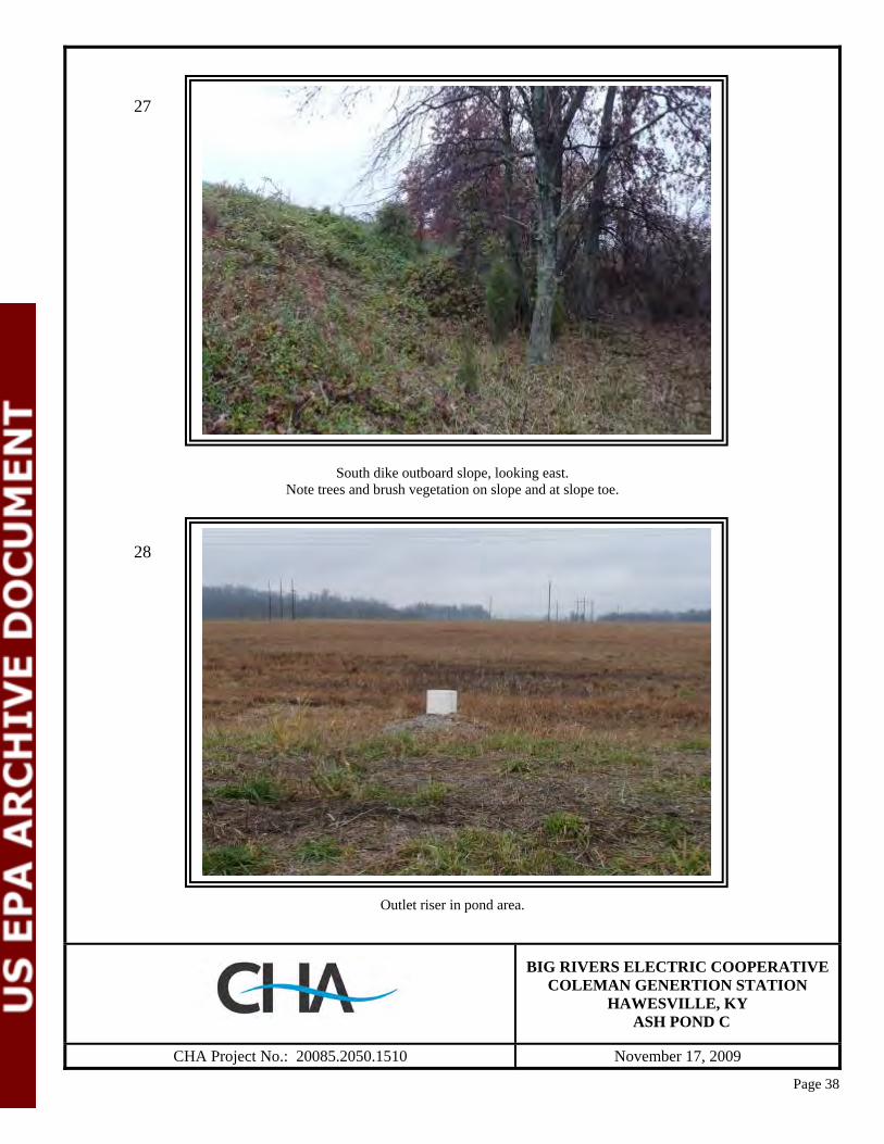
South dike outboard slope, looking east. Note trees and brush vegetation on slope and at slope toe.
Outlet riser in pond area.
BIG RIVERS ELECTRIC COOPERATIVE
COLEMAN GENERTION STATION HAWESVILLE, KY
ASH POND C
CHA Project No.: 20085.2050.1510 November 17, 2009
27
28
Page 39
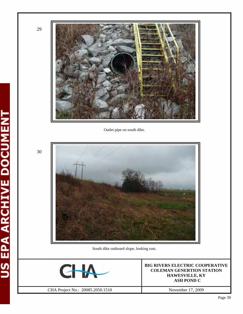
Outlet pipe on south dike.
South dike outboard slope, looking east.
BIG RIVERS ELECTRIC COOPERATIVE
COLEMAN GENERTION STATION HAWESVILLE, KY
ASH POND C
CHA Project No.: 20085.2050.1510 November 17, 2009
29
30
Page 40
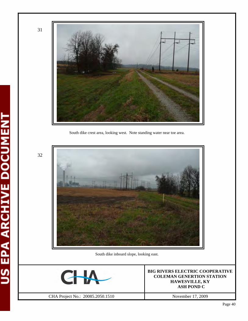
South dike crest area, looking west. Note standing water near toe area.
South dike inboard slope, looking east.
BIG RIVERS ELECTRIC COOPERATIVE
COLEMAN GENERTION STATION HAWESVILLE, KY
ASH POND C
CHA Project No.: 20085.2050.1510 November 17, 2009
31
32

Page 41
South dike outboard slope from west corner, looking east.
West dike crest, looking south along abandoned railroad spur.
BIG RIVERS ELECTRIC COOPERATIVE
COLEMAN GENERTION STATION HAWESVILLE, KY
ASH POND C
CHA Project No.: 20085.2050.1510 November 17, 2009
33
34

Page 42
West dike outboard slope, looking south.
West dike outboard slope, looking north.
BIG RIVERS ELECTRIC COOPERATIVE
COLEMAN GENERTION STATION HAWESVILLE, KY
ASH POND C
CHA Project No.: 20085.2050.1510 November 17, 2009
35
36
Page 43
West dike crest, looking north.
West dike inboard slope, looking north.
BIG RIVERS ELECTRIC COOPERATIVE
COLEMAN GENERTION STATION HAWESVILLE, KY
ASH POND C
CHA Project No.: 20085.2050.1510 November 17, 2009
37
38

Page 44
Mowing ruts in surface on west dike outboard slope.
North dike outboard slope near facility driveway, looking east.
BIG RIVERS ELECTRIC COOPERATIVE
COLEMAN GENERTION STATION HAWESVILLE, KY
ASH POND C
CHA Project No.: 20085.2050.1510 November 17, 2009
39
40
Page 45
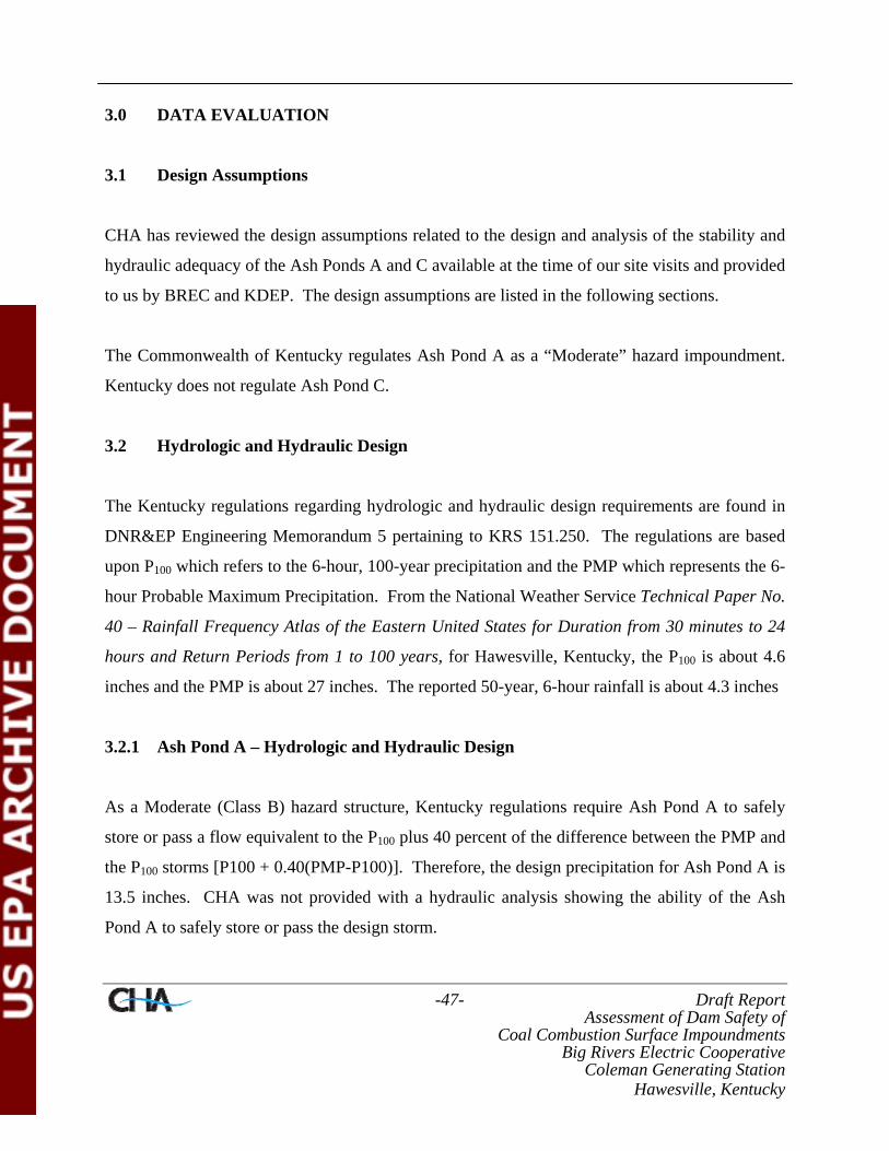
North dike inboard slope, looking east.
Old outlet structure to closed and reclaimed North Pond.
BIG RIVERS ELECTRIC COOPERATIVE
COLEMAN GENERTION STATION HAWESVILLE, KY
ASH POND C
CHA Project No.: 20085.2050.1510 November 17, 2009
41
42

Page 46
Looking north from north dike to reclaimed North Pond area.
North dike crest area, looking east.
BIG RIVERS ELECTRIC COOPERATIVE
COLEMAN GENERTION STATION HAWESVILLE, KY
ASH POND C
CHA Project No.: 20085.2050.1510 November 17, 2009
43
44
-47- Draft Report Assessment of Dam Safety of
Coal Combustion Surface Impoundments Big Rivers Electric Cooperative
Coleman Generating Station Hawesville, Kentucky
3.0 DATA EVALUATION
3.1 Design Assumptions
CHA has reviewed the design assumptions related to the design and analysis of the stability and
hydraulic adequacy of the Ash Ponds A and C available at the time of our site visits and provided
to us by BREC and KDEP. The design assumptions are listed in the following sections.
The Commonwealth of Kentucky regulates Ash Pond A as a “Moderate” hazard impoundment.
Kentucky does not regulate Ash Pond C.
3.2 Hydrologic and Hydraulic Design
The Kentucky regulations regarding hydrologic and hydraulic design requirements are found in
DNR&EP Engineering Memorandum 5 pertaining to KRS 151.250. The regulations are based
upon P100 which refers to the 6-hour, 100-year precipitation and the PMP which represents the 6-
hour Probable Maximum Precipitation. From the National Weather Service Technical Paper No.
40 – Rainfall Frequency Atlas of the Eastern United States for Duration from 30 minutes to 24
hours and Return Periods from 1 to 100 years, for Hawesville, Kentucky, the P100 is about 4.6
inches and the PMP is about 27 inches. The reported 50-year, 6-hour rainfall is about 4.3 inches
3.2.1 Ash Pond A – Hydrologic and Hydraulic Design
As a Moderate (Class B) hazard structure, Kentucky regulations require Ash Pond A to safely
store or pass a flow equivalent to the P100 plus 40 percent of the difference between the PMP and
the P100 storms [P100 + 0.40(PMP-P100)]. Therefore, the design precipitation for Ash Pond A is
13.5 inches. CHA was not provided with a hydraulic analysis showing the ability of the Ash
Pond A to safely store or pass the design storm.

-48- Draft Report Assessment of Dam Safety of
Coal Combustion Surface Impoundments Big Rivers Electric Cooperative
Coleman Generating Station Hawesville, Kentucky
Because Ash Pond A is a fully diked (i.e., above original grade) structure, inflow from a storm is
limited only to the rainfall runoff that lands on the pond surface and the crest and upstream
slopes of the dikes. Therefore, the rise in water surface elevation is not anticipated to be
significantly more than the 13.5 inches of the design storm. However, this should be verified.
3.2.2 Ash Pond C – Hydrologic and Hydraulic Design
Ash Pond C is not regulated by KYDEP therefore there are no specific H&H guidelines for its
design. CHA suggests the impoundment be evaluated for susceptibility to overtopping during a
reasonable design storm.
3.3 Structural Adequacy & Stability
The Kentucky regulations and guidelines for dam safety do not provide specific factors of safety
for slope stability. Therefore, CHA recommends following industry guidelines such as those
found in the US Army Corps of Engineers Engineering Manual (EM) 1110-2-1902. Table 2
below summarizes the guidance values for minimum factors of safety for earthen embankment
dams.
Table 2 - Minimum Safety Factors Recommended by US Army Corps of Engineers
Load Case Required Minimum Factor of Safety
Steady State Seepage at Normal Pool 1.5 Maximum Surcharge Pool (Flood) Condition 1.4
Rapid Drawdown Condition 1.3 Seismic Conditions from Present Pool Elevation 1.0
Based on recent probabilistic hazard analyses performed by the United States Geological Society
(USGS) accelerations of about 0.0704g and 0.1895g are representative of seismic accelerations
with a 10 and 2 percent probability of exceedance in 50 years, respectively (about 500-year and
2,500-year events, respectively).
-49- Draft Report Assessment of Dam Safety of
Coal Combustion Surface Impoundments Big Rivers Electric Cooperative
Coleman Generating Station Hawesville, Kentucky
CHA was not provided with information regarding stability analyses performed for the ash
ponds. Without having received site specific subsurface information, CHA was unable to
perform a preliminary stability analyses for dikes. Our recommendation that subsurface
investigations and stability analyses be performed for the ash ponds is discussed in Section 4.2.
3.4 Foundation Conditions
CHA has not been provided with geotechnical subsurface information for Ash Ponds A or C.
CHA was provided with several record drawings related to construction of the Ash Pond A. The
western half of the south dike was constructed by raising and widening a berm for the “North
Ash Pond” to the downstream side. We understand from plant personnel that the North Ash
Pond no longer exists and drawings for Ash Pond A indicate in areas of access ramps and pipe
benches that were constructed within the former North Ash Pond that ash was to be removed.
3.5 Inspections
3.5.1 State Inspections
CHA was provided with KDEP inspection reports for Ash Pond A from 2004, 2006, and 2009.
KDEP does not inspect Ash Pond C. The Table 2 summarizes items noted by KDEP related to
Ash Pond A:
Table 2 – Summary of KDEP Inspections of Ash Pond A 2009 KDEP Inspection of Ash Pond A • Erosion rills forming in the crest and travelling down the slope. KDEP indicated that
upstream slope gravel cover needs to be recovered. • Potholes in the crest. KDEP indicated that these need to be filled. 2006 KDEP Inspection of Ash Pond A • Small trees/brush were noted on the downstream slope. KDEP indicated the brush should be
sprayed or mowed frequently enough to stop the tree growth. 2004 KDEP Inspection of Ash Pond A • Animal burrows, and some brush were encountered. KDEP indicated that the brush must be
removed and animal burrows filled. • Crest roadway disturbed due to ongoing ash removal operations. KDEP indicated the
roadway must be graveled when construction is complete.

-50- Draft Report Assessment of Dam Safety of
Coal Combustion Surface Impoundments Big Rivers Electric Cooperative
Coleman Generating Station Hawesville, Kentucky
3.5.2 Inspections by Engineering Consultants
BREC (operating as Western Kentucky Energy at the time) hired Associated Engineers, Inc., to
perform inspections of Ash Ponds A and C and to provide training to BREC (Western Kentucky
Energy) personnel on dam safety issues so they can better make inspections in between those by
the state or consultant. CHA was provided with inspection reports by Associated Engineers for
inspections made on March 24, 2009 and June 5, 2009.
During the March inspection at Ash Pond A, Associated Engineers noted erosion on the North
Dike, and a possible scarp and bulge on the South Dike, as well as significant rodent activity on
the slope facing the Ohio River. The June report indicates that recommended repairs are in
progress and no mention of scarps, bulges or erosion is reported. A new comment on the June
report indicates that ash deposits are resulting in water being impounded within the pond above
the crest elevation of the dam.
Associated Engineers did not note changes in condition between the March and June inspections
at Ash Pond C, although the June inspection was partially hampered by vegetation which had not
been recently mowed. The report suggests that mowing was occurring at the time of the
inspection.
3.5.3 Inspections by Plant Personnel
Plant personnel have been making roughly monthly inspections. CHA was provided with copies
of their inspection reports. Table 3 summaries the findings of the inspections.

-51- Draft Report Assessment of Dam Safety of
Coal Combustion Surface Impoundments Big Rivers Electric Cooperative
Coleman Generating Station Hawesville, Kentucky
Table 3 – Summary of BREC Monthly Inspections
BREC Monthly Inspections of Ash Pond A
05/14/08 – Dam was mowed in 2007, slopes covered with grass and light brush.
02/13/09 – Dam was mowed in 2008 as scheduled. Slopes are covered in grass and light brush.
05/28/09 – Possible scarp at toe of dam on northeast corner under rip rap, will discuss with Associated in June during their inspection. Working on rodent problem. Scheduling improvement work. 06/30/09 – Inside dike erosion repaired, potholes in road repaired. Work proceeding on catch basins to lower level below dike.
07/31/09 – No maintenance items recorded. Checklist still notes cracks, scarps, sloughing or bulging on the slope.
08/31/09 – No maintenance items recorded. Checklist still notes cracks, scarps, sloughing or bulging on the slope.
09/29/09 – No maintenance items recorded. Checklist still notes cracks, scarps, sloughing or bulging on the slope. Notes hump towards coal pile.
10/23/09 – No maintenance items recorded. Checklist still notes cracks, scarps, sloughing or bulging on the slope. Notes hump towards coal pile. West side of pond has less free board than the east. Personnel notified.
BREC Monthly Inspection of Ash Pond C
05/28/09 – No maintenance items recorded. New discharge stand pipe drain tile through dike.
06/30/09 – No maintenance items recorded. Reported new discharge stand pipe below dam level, drain tile through dike is plugged with concrete. Dirt storage area repair scheduled for July and dredge area scheduled for August. 07/31/09 – No maintenance items recorded.
08/31/09 – No maintenance items recorded.
09/29/09 – No maintenance items recorded.
10/23/09 – No maintenance items recorded.

-52- Draft Report Assessment of Dam Safety of
Coal Combustion Surface Impoundments Big Rivers Electric Cooperative
Coleman Generating Station Hawesville, Kentucky
4.0 CONCLUSIONS/RECOMMENDATIONS
4.1 Acknowledgement of Management Unit Condition
I acknowledge that the management units referenced herein were personally inspected by me and
was found to be in the following condition: Fair. This indicates acceptable performance is
expected under required loading conditions in accordance with applicable safety regulatory
criteria, however some additional analyses should be performed and documented to verify that
these criteria are met.
Evidence was observed indicating that BREC attempts and maintains a proactive maintenance
program at these facilities. These efforts should be continued.
CHA presents recommendations for maintenance, monitoring and further studies where
applicable to bring these facilities into a satisfactory rating in the following sections.
4.2 Ash Pond A and Ash Pond C- Stability Analyses
Presently there is no quantitative measurement of the dike stability. Therefore CHA
recommends that detailed stability analyses be performed for the Ash Ponds. CHA was not
provided with information regarding stability analyses performed prior to or following
construction of the ponds nor was information regarding properties of the embankment and
foundation soils provided.
The stability analyses for each pond should include a subsurface investigation to determine
existing soil parameters in the embankments and foundation soils and the installation of
piezometers to determine the current pheratic surface. Loading conditions that should be
modeled should include those listed in Table 2 in Section 3.3.

-53- Draft Report Assessment of Dam Safety of
Coal Combustion Surface Impoundments Big Rivers Electric Cooperative
Coleman Generating Station Hawesville, Kentucky
4.3 Ash Pond A and Ash Pond C- Hydrologic and Hydraulic Analysis
Ash Pond A is classified as a Moderate (Class B) hazard structure according to Kentucky
regulations. BREC has not provided CHA with a hydraulic analysis showing the ability of Ash
Pond A to safely store or pass a flow equivalent to the P100 plus 40 percent of the difference
between the PMP and the P100 storms [P100 + 0.40(PMP-P100)] as established in the Kentucky
regulations . CHA recommends that evaluations be prepared for the pond to determine the
ability of the Ash Pond A to safely store or pass the design storm event. Though Kentucky does
not actively regulate Ash Pond C and has not established standards for unregulated dams, a
similar analysis should be prepared for Ash Pond C to determine that it does not overtop in the
event of a probable heavy storm event.
4.4 Ash Pond A – Freeboard
Kentucky regulations presently do not have a minimum freeboard requirement; only that the
impoundment contain or safely pass the design event without overtopping. The available
freeboard on the dikes at this pond appeared to vary from approximately 1.5 to 3 feet. This
would seem to allow little room to account for wave action during a strong storm event. CHA
recommends that the crest areas be graded and the pond level established so the freeboard is
consistent around the pond on the dikes. Consideration should also be given to lowering the
pond level to allow for a margin of error for wave run-up should the design storm event occur.
Wave action on the dikes can of particular concern in light of the potential for erosion on some
areas of the dike crests.
4.5 Ash Pond A – Crest Area and Inboard Slope Maintenance
Intermittent erosion rills and beaching erosion was observed on the dikes adjacent to the open
water pond areas. This should not cause an immediate safety concern as long as a sufficient
freeboard and dike crest width is maintained. Based upon the conditions encountered, this
-54- Draft Report Assessment of Dam Safety of
Coal Combustion Surface Impoundments Big Rivers Electric Cooperative
Coleman Generating Station Hawesville, Kentucky
erosion is most likely due to poorly compacted material pushed to the edge of the dike on the
inboard side. At present the most probable concerns is incremental loss of capacity over time as
the erosion rills transport material into the pond area. CHA recommends that the crest and slope
areas be dressed to remove loose materials and appropriately compacted to increase their erosion
resistance. An alternative may be to place heavier crushed rock and stone on the crest and
inboard slope. These steps can also be taken to repair softened areas and depressions or ruts
holding water in the crest access road, such as those noted along the south dike.
4.6 Ash Pond A – Instrumentation and Monitoring
Presently the dikes do not have instrumentation that permits tracking of embankment
performance such as seepage weirs, piezometers, deformation monuments, or inclinometers.
Such instrumentation and routine measurements obtained from these devices permit the
monitoring of water levels, volumetric flow, and deformations over time that are not readily
observable and aid in assessing the embankment. Once a trend has been established for the
embankment, abrupt changes in these measurements can be used to guide a course of action and
ideally stop a failure or breach before it occurs. CHA recommends that some manner of
monitoring the dike performance be installed and that at a minimum it include piezometers at the
crest and toe of the dike.
4.7 Ash Pond A and Ash Pond C- Grass Slope Maintenance
In general, a good, stable grass cover was observed on the outboard slope areas. Routine
mowing and reseeding should continue as needed. In some areas, surficial slope deformation
(rutting) due to these mowing activities were observed. It is likely that this rutting is the result of
repeated passes of large riding equipment in these areas or attempting to mow too soon after a
rain event. CHA recommends that mowing activities not commence on the slopes until the areas
are fairly dry and the surface soils have stiffened.
-55- Draft Report Assessment of Dam Safety of
Coal Combustion Surface Impoundments Big Rivers Electric Cooperative
Coleman Generating Station Hawesville, Kentucky
A related grass slope maintenance item is erosion. Erosion rills, most of them grass and weed
covered, occurring along the embankment slopes should be filled with compacted soil and
seeded to stabilize the repaired area. This should also help with reducing the slope softening and
subsequent mower rutting that can occur in these areas.
4.8 Ash Pond C – Heavy Vegetation and Tree Control on the South Dike
The heavy vegetation and trees established along the south dike adjacent to the drainage feature
need to be removed. This should be done at least to the toe of the constructed dike and to the
eastern extent of the dike where it ties in to the natural grade at the incised portion of the pond.
According to an excerpt from the meeting minutes of a meeting held November 9, 2009, this tree
removal activity was on an action item list, so it appears if this was recommended previously.
To aid in determining the extent of tree removal, it is also suggested that a detailed survey be
obtained in the area so that vegetation along the natural swale can be retained.
4.9 Ash Pond A – Rodent Control
Isolated rodent burrows were observed along the outboard slopes of Ash Pond A. At one
location a trap was observed indicating that BREC is actively moving to control these animals.
This rodent control measure and others should continue to be utilized as needed.
4.10 Ash Pond A and Ash Pond C – Rock Armament Vegetation Control
Ash Pond A has rock toe and rock slope protection on its east dike facing the Ohio River and
Ash Pond C has rock outlet protection for its spillway. Woody and weedy vegetation should not
be allowed to establish itself in this armament. Hand removal or a herbicide (applied in
accordance with applicable laws/rules) can be employed to control this growth.
-56- Draft Report Assessment of Dam Safety of
Coal Combustion Surface Impoundments Big Rivers Electric Cooperative
Coleman Generating Station Hawesville, Kentucky
5.0 CLOSING
The information presented in this report is based on visual field observations, review of reports
by others and this limited knowledge of the history of the Coleman Generating Station surface
impoundments. The recommendations presented are based, in part, on project information
available at the time of this report. No other warranty, expressed or implied is made. Should
additional information or changes in field conditions occur the conclusions and
recommendations provided in this report should be re-evaluated by an experienced engineer.
Draft Report Assessment of Dam Safety of
Coal Combustion Surface Impoundments Big Rivers Electric Cooperative
Coleman Generating Station Hawesville, Kentucky
APPENDIX A
Completed EPA Coal Combustion Dam Inspection Checklist Forms
&
Completed EPA Coal Combustion Waste (CCW) Impoundment Inspection Forms
Site Name: Date:Unit Name: Operator's Name: Unit I.D.: Hazard Potential Classification: High Significant Low
Inspector's Name:
Coal Combustion Dam Inspection Checklist FormUS EnvironmentalProtection Agency
Check the appropriate box below. Provide comments when appropriate. If not applicable or not available, record "N/A". Any unusual conditions or construction practices that should be noted in the comments section. For large diked embankments, separate checklists may be used for different embankment areas. If separate forms are used, identify approximate area that the form applies to in comments.
Yes No Yes No
1. Frequency of Company's Dam Inspections? 18. Sloughing or bulging on slopes?
2. Pool elevation (operator records)? 19. Major erosion or slope deterioration?
3. Decant inlet elevation (operator records)? 20. Decant Pipes:
4. Open channel spillway elevation (operator records)? Is water entering inlet, but not exiting outlet?
5. Lowest dam crest elevation (operator records)? Is water exiting outlet, but not entering inlet?
6. If instrumentation is present, are readings recorded (operator records)? Is water exiting outlet flowing clear?
7. Is the embankment currently under construction? 21. Seepage (specify location, if seepage carries fines, and approximate seepage rate below):
8. Foundation preparation (remove vegetation,stumps, topsoil in area where embankment fill will be placed)? From underdrain?
9. Trees growing on embankment? (If so, indicate largest diameter below) At isolated points on embankment slopes?
10. Cracks or scarps on crest? At natural hillside in the embankment area?
11. Is there significant settlement along the crest? Over widespread areas?
12. Are decant trashracks clear and in place? From downstream foundation area?
13. Depressions or sinkholes in tailings surface orwhirlpool in the pool area? "Boils" beneath stream or ponded water?
14. Clogged spillways, groin or diversion ditches? Around the outside of the decant pipe?
15. Are spillway or ditch linings deteriorated? 22. Surface movements in valley bottom or on hillside?
16. Are outlets of decant or underdrains blocked? 23. Water against downstream toe?
17. Cracks or scarps on slopes? 24. Were Photos taken during the dam inspection?
Major adverse changes in these items could cause instability and should be reported forfurther evaluation. Adverse conditions noted in these items should normally be described (extent, location, volume, etc.) in the space below and on the back of this sheet.
Inspection Issue # Comments
EPA FORM -XXXX
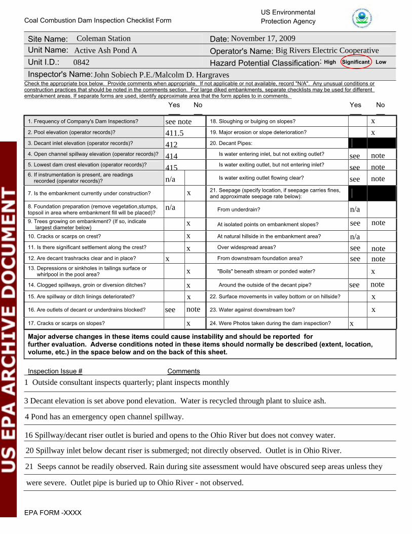
Coleman Station November 17, 2009
Active Ash Pond A Big Rivers Electric Cooperative
0842
John Sobiech P.E./Malcolm D. Hargraves
see note
411.5
412
414 see
415 see
n/a see
x
x
note
note
note
n/a
see
n/a
n/aseeseex
see
x
see
x
notex
note
x
notex
x
note
x
x
x
x
x
note
x
1 Outside consultant inspects quarterly; plant inspects monthly
3 Decant elevation is set above pond elevation. Water is recycled through plant to sluice ash.
20 Spillway inlet below decant riser is submerged; not directly observed. Outlet is in Ohio River.
4 Pond has an emergency open channel spillway.
16 Spillway/decant riser outlet is buried and opens to the Ohio River but does not convey water.
21 Seeps cannot be readily observed. Rain during site assessment would have obscured seep areas unless they
were severe. Outlet pipe is buried up to Ohio River - not observed.

U. S. Environmental Protection Agency
Coal Combustion Waste (CCW)Impoundment Inspection
Impoundment NPDES Permit # _____________________ INSPECTOR______________________Date ____________________________________
Impoundment Name ________________________________________________________Impoundment Company ____________________________________________________EPA Region ___________________State Agency (Field Office) Addresss __________________________________________
__________________________________________Name of Impoundment _____________________________________________________(Report each impoundment on a separate form under the same Impoundment NPDES Permit number)
New ________ Update _________
Yes NoIs impoundment currently under construction? ______ ______Is water or ccw currently being pumped into the impoundment? ______ ______
IMPOUNDMENT FUNCTION: _____________________________________________
Nearest Downstream Town : Name ____________________________________Distance from the impoundment __________________________ ImpoundmentLocation: Longitude ______ Degrees ______ Minutes ______ Seconds Latitude ______ Degrees ______ Minutes ______ Seconds
State _________ County ___________________________
Does a state agency regulate this impoundment? YES ______ NO ______
If So Which State Agency?___________________________________________
EPA Form XXXX-XXX, Jan 09 1
KY0001937 Sobiech/Hargraves
November 19, 2009
Active Ash Pond A
Big Rivers Electric Cooperative (Western Kentucky Electric)4
Owensboro Regional EPA Office3032 Alvey Park Drive W.; Ste.700; Owensboro, ky 42303
Active Ash Pond A
x
x
x
Fly ash and bottom ash disposal
Troy, IN1.6 miles
86 47 44.9
37 58 0.0Kentucky Hancock
x
DEP-Div. of Water, Dam Safety & Flood Plain Compliance

HAZARD POTENTIAL (In the event the impoundment should fail, the following would occur):
______ LESS THAN LOW HAZARD POTENTIAL: Failure or misoperation of the dam results in no probable loss of human life or economic or environmental losses.
______ LOW HAZARD POTENTIAL: Dams assigned the low hazard potential classification are those where failure or misoperation results in no probable loss of human life and low economic and/or environmental losses. Losses are principally limited to the owner’s property.
______ SIGNIFICANT HAZARD POTENTIAL: Dams assigned the significant hazard potential classification are those dams where failure or misoperation results in no probable loss of human life but can cause economic loss, environmental damage, disruption of lifeline facilities, or can impact other concerns. Significant hazard potential classification dams are often located in predominantly rural or agricultural areas but could be located in areas with population and significant infrastructure.
______ HIGH HAZARD POTENTIAL: Dams assigned the high hazard potential classification are those where failure or misoperation will probably cause loss of human life.
DESCRIBE REASONING FOR HAZARD RATING CHOSEN: _______________________________________________________________________________________________________________________________________________________________________________________________________________________________________________________________________________________________________________________________________________________________________________________________________________________________________________________________________________________________________________________________________________________________________________________________________________________________________________________________________________________________________________________________________________________________________________________________________________________________________________________________________________________________________________________________________________________________________________________________________________
EPA Form XXXX-XXX, Jan 09 2
x
Failure of dike would impact the Ohio River and plant facilities.

CONFIGURATION:
Height original ground
CROSS-VALLEY
Height original ground
SIDE-HILL
Water or ccw
DIKED
original ground Height
Height original ground
CROSS-VALLEY
Water or ccw
original ground
SIDE-HILL
Height original ground
CROSS-VALLEY
original ground
SIDE-HILL
original ground
SIDE-HILL
original ground
SIDE-HILL
original original ground ground
SIDE-HILLSIDE-HILL
original ground
SIDE-HILLSIDE-HILL
original ground Height
SIDE-HILLSIDE-HILLSIDE-HILL
Height Height original ground original ground Height
SIDE-HILL
original ground Height
SIDE-HILL
Water or ccw
original ground Height
SIDE-HILL
INCISED
Water or ccw
original ground
_____ Cross-Valley _____ Side-Hill _____ Diked _____ Incised (form completion optional)_____ Combination Incised/Diked Embankment Height __________ feet Embankment Material_______________Pool Area __________________ acres Liner ____________________________ Current Freeboard ___________ feet Liner Permeability _________________
EPA Form XXXX-XXX, Jan 09 3
x
30 Earth fill23 none
1.5 to 3.5 n/a

TYPE OF OUTLET (Mark all that apply)
TRAPEZOIDAL
Avg Depth
Bottom Width
Depth
TRIANGULAR_____ Open Channel Spillway_____ Trapezoidal Top Width Top Width
_____ Triangular
RECTANGULAR IRREGULAR
Depth _____ Rectangular _____ Irregular
_____ depth _____ bottom (or average) width
Width
Depth
Average Width
_____ top width
_____ Outlet
_____ inside diameter
Material Inside Diameter
_____ corrugated metal _____ welded steel _____ concrete _____ plastic (hdpe, pvc, etc.) _____ other (specify) ____________________
Is water flowing through the outlet? YES _______ NO _______
_____ No Outlet
_____ Other Type of Outlet (specify) ________________________________
The Impoundment was Designed By ______________________________________________________________________________________________________
EPA Form XXXX-XXX, Jan 09 4
(to recycle water back to the plant)
(Emergency Spillway)
xx
1'40'50'
x
36"
x
x
Burns and Roe Engineers and Constructors, Inc.

Has there ever been a failure at this site? YES __________ NO ___________
If So When? ___________________________
If So Please Describe : _____________________________________________________________________________________________________________________________________________________________________________________________________________________________________________________________________________________________________________________________________________________________________________________________________________________________________________________________________________________________________________________________________________________________________________________________________________________________________________________________________________________________________________________________________________________________________________________________________________________________________________________________________________________________________________________________________________________________________________________________________________________________________________________________________________________________________________________________________________________________________________________________________________________________________________________________________________________________________________________________________________________________________________________________________________________________________________________________________________________________________________________________________________________________________________________________________________________________________________________________________________________________________________________________________________________________________________________________________________________________________________________________________________________________________________________________________________________________________________________________________________________________________________________________________________________________________________________________________________________________________________________________________________________________________________
EPA Form XXXX-XXX, Jan 09 5
x

Has there ever been significant seepages at this site? YES _______ NO _______
If So When? ___________________________
IF So Please Describe: _______________________________________________________________________________________________________________________________________________________________________________________________________________________________________________________________________________________________________________________________________________________________________________________________________________________________________________________________________________________________________________________________________________________________________________________________________________________________________________________________________________________________________________________________________________________________________________________________________________________________________________________________________________________________________________________________________________________________________________________________________________________________________________________________________________________________________________________________________________________________________________________________________________________________________________________________________________________________________________________________________________________________________________________________________________________________________________________________________________________________________________________________________________________________________________________________________________________________________________________________________________________________________________________________________________________________________________________________________________________________________________________________________________________________________________________________________________________________________________________________________________________________________________________________________________________________________________________________________________________________________________________________________________________________________________
EPA Form XXXX-XXX, Jan 09 6
x

Has there ever been any measures undertaken to monitor/lowerPhreatic water table levels based on past seepages or breaches at this site? YES ________NO ________
If so, which method (e.g., piezometers, gw pumping,...)? ____________________
If so Please Describe : ____________________________________________________________________________________________________________________________________________________________________________________________________________________________________________________________________________________________________________________________________________________________________________________________________________________________________________________________________________________________________________________________________________________________________________________________________________________________________________________________________________________________________________________________________________________________________________________________________________________________________________________________________________________________________________________________________________________________________________________________________________________________________________________________________________________________________________________________________________________________________________________________________________________________________________________________________________________________________________________________________________________________________________________________________________________________________________________________________________________________________________________________________________________________________________________________________________________________________________________________________________________________________________________________________________________________________________________________________________________________________________________________________________________________________________________________________________________________________________________________________________________________________________________________________________________________________________________________________________________________________________________________________________________________________________
EPA Form XXXX-XXX, Jan 09 7
x
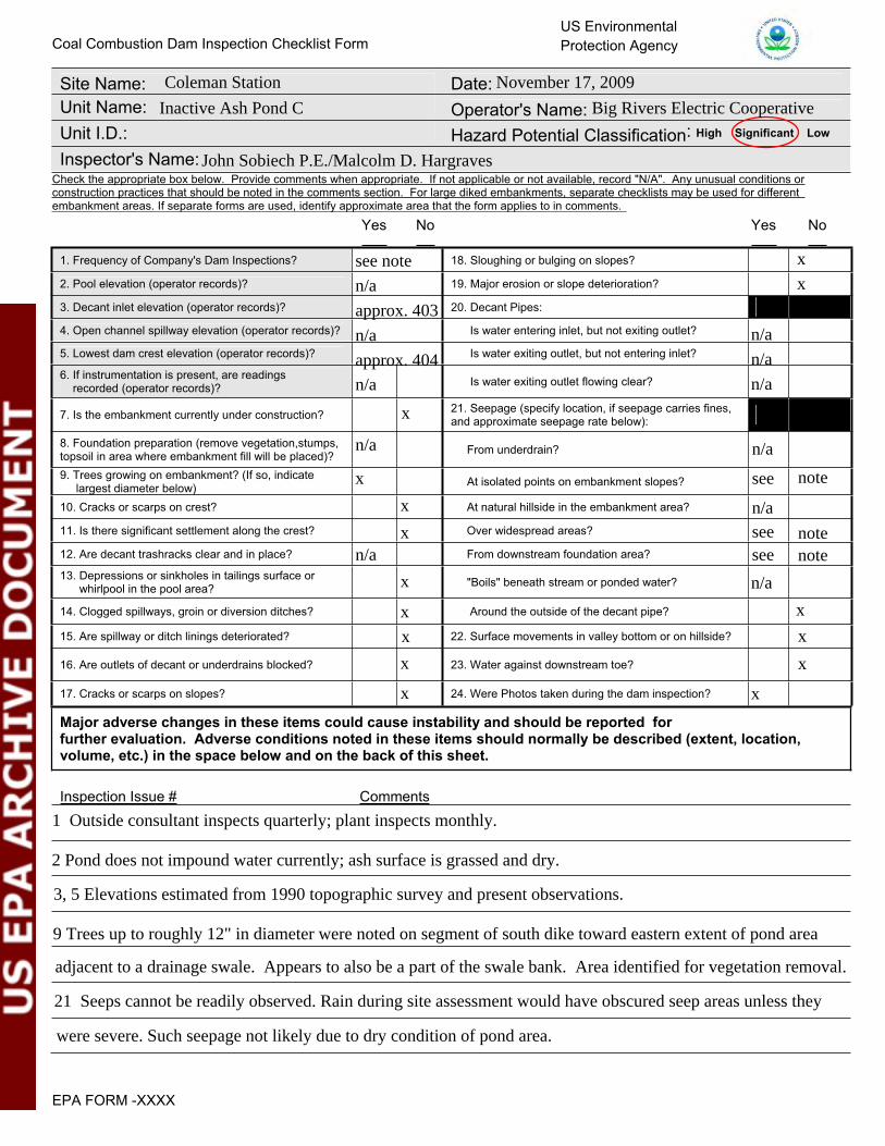
Site Name: Date:Unit Name: Operator's Name: Unit I.D.: Hazard Potential Classification: High Significant Low
Inspector's Name:
Coal Combustion Dam Inspection Checklist FormUS EnvironmentalProtection Agency
Check the appropriate box below. Provide comments when appropriate. If not applicable or not available, record "N/A". Any unusual conditions or construction practices that should be noted in the comments section. For large diked embankments, separate checklists may be used for different embankment areas. If separate forms are used, identify approximate area that the form applies to in comments.
Yes No Yes No
1. Frequency of Company's Dam Inspections? 18. Sloughing or bulging on slopes?
2. Pool elevation (operator records)? 19. Major erosion or slope deterioration?
3. Decant inlet elevation (operator records)? 20. Decant Pipes:
4. Open channel spillway elevation (operator records)? Is water entering inlet, but not exiting outlet?
5. Lowest dam crest elevation (operator records)? Is water exiting outlet, but not entering inlet?
6. If instrumentation is present, are readings recorded (operator records)? Is water exiting outlet flowing clear?
7. Is the embankment currently under construction? 21. Seepage (specify location, if seepage carries fines, and approximate seepage rate below):
8. Foundation preparation (remove vegetation,stumps, topsoil in area where embankment fill will be placed)? From underdrain?
9. Trees growing on embankment? (If so, indicate largest diameter below) At isolated points on embankment slopes?
10. Cracks or scarps on crest? At natural hillside in the embankment area?
11. Is there significant settlement along the crest? Over widespread areas?
12. Are decant trashracks clear and in place? From downstream foundation area?
13. Depressions or sinkholes in tailings surface orwhirlpool in the pool area? "Boils" beneath stream or ponded water?
14. Clogged spillways, groin or diversion ditches? Around the outside of the decant pipe?
15. Are spillway or ditch linings deteriorated? 22. Surface movements in valley bottom or on hillside?
16. Are outlets of decant or underdrains blocked? 23. Water against downstream toe?
17. Cracks or scarps on slopes? 24. Were Photos taken during the dam inspection?
Major adverse changes in these items could cause instability and should be reported forfurther evaluation. Adverse conditions noted in these items should normally be described (extent, location, volume, etc.) in the space below and on the back of this sheet.
Inspection Issue # Comments
EPA FORM -XXXX
Coleman Station November 17, 2009
Inactive Ash Pond C Big Rivers Electric Cooperative
John Sobiech P.E./Malcolm D. Hargraves
see note
n/a
approx. 403
n/a n/a
approx. 404 n/a
n/a n/a
x
x
n/a
see
n/a
n/a
x
seesee
n/a
n/a
x
x
note
note
x
notex
x
x
x
x
x
x
x
x
1 Outside consultant inspects quarterly; plant inspects monthly.
2 Pond does not impound water currently; ash surface is grassed and dry.
adjacent to a drainage swale. Appears to also be a part of the swale bank. Area identified for vegetation removal.
3, 5 Elevations estimated from 1990 topographic survey and present observations.
9 Trees up to roughly 12" in diameter were noted on segment of south dike toward eastern extent of pond area
21 Seeps cannot be readily observed. Rain during site assessment would have obscured seep areas unless they
were severe. Such seepage not likely due to dry condition of pond area.

U. S. Environmental Protection Agency
Coal Combustion Waste (CCW)Impoundment Inspection
Impoundment NPDES Permit # _____________________ INSPECTOR______________________Date ____________________________________
Impoundment Name ________________________________________________________Impoundment Company ____________________________________________________EPA Region ___________________State Agency (Field Office) Addresss __________________________________________
__________________________________________Name of Impoundment _____________________________________________________(Report each impoundment on a separate form under the same Impoundment NPDES Permit number)
New ________ Update _________
Yes NoIs impoundment currently under construction? ______ ______Is water or ccw currently being pumped into the impoundment? ______ ______
IMPOUNDMENT FUNCTION: _____________________________________________
Nearest Downstream Town : Name ____________________________________Distance from the impoundment __________________________ ImpoundmentLocation: Longitude ______ Degrees ______ Minutes ______ Seconds Latitude ______ Degrees ______ Minutes ______ Seconds
State _________ County ___________________________
Does a state agency regulate this impoundment? YES ______ NO ______
If So Which State Agency?___________________________________________
EPA Form XXXX-XXX, Jan 09 1
KY0001937 Sobiech/Hargraves
November 17, 2009
Inactive Ash Pond C
Big Rivers Electric Cooperative (Western Kentucky Electric)4
Owensboro Regional EPA Office3032 Alvey Park Drive W.; Ste.700; Owensboro, ky 42303
Inactive Ash Pond C
x
x
x
Ash dewatering area when Active Ash Pond A is dredged
Troy, IN1.9 miles
86 47 41.6
37 57 23.8Kentucky Hancock
x

HAZARD POTENTIAL (In the event the impoundment should fail, the following would occur):
______ LESS THAN LOW HAZARD POTENTIAL: Failure or misoperation of the dam results in no probable loss of human life or economic or environmental losses.
______ LOW HAZARD POTENTIAL: Dams assigned the low hazard potential classification are those where failure or misoperation results in no probable loss of human life and low economic and/or environmental losses. Losses are principally limited to the owner’s property.
______ SIGNIFICANT HAZARD POTENTIAL: Dams assigned the significant hazard potential classification are those dams where failure or misoperation results in no probable loss of human life but can cause economic loss, environmental damage, disruption of lifeline facilities, or can impact other concerns. Significant hazard potential classification dams are often located in predominantly rural or agricultural areas but could be located in areas with population and significant infrastructure.
______ HIGH HAZARD POTENTIAL: Dams assigned the high hazard potential classification are those where failure or misoperation will probably cause loss of human life.
DESCRIBE REASONING FOR HAZARD RATING CHOSEN: _______________________________________________________________________________________________________________________________________________________________________________________________________________________________________________________________________________________________________________________________________________________________________________________________________________________________________________________________________________________________________________________________________________________________________________________________________________________________________________________________________________________________________________________________________________________________________________________________________________________________________________________________________________________________________________________________________________________________________________________________________________
EPA Form XXXX-XXX, Jan 09 2
x
Failure of the south dike would impact drainage swale leading to the Ohio River.

CONFIGURATION:
Height original ground
CROSS-VALLEY
Height original ground
SIDE-HILL
Water or ccw
DIKED
original ground Height
Height original ground
CROSS-VALLEY
Water or ccw
original ground
SIDE-HILL
Height original ground
CROSS-VALLEY
original ground
SIDE-HILL
original ground
SIDE-HILL
original ground
SIDE-HILL
original original ground ground
SIDE-HILLSIDE-HILL
original ground
SIDE-HILLSIDE-HILL
original ground Height
SIDE-HILLSIDE-HILLSIDE-HILL
Height Height original ground original ground Height
SIDE-HILL
original ground Height
SIDE-HILL
Water or ccw
original ground Height
SIDE-HILL
INCISED
Water or ccw
original ground
_____ Cross-Valley _____ Side-Hill _____ Diked _____ Incised (form completion optional)_____ Combination Incised/Diked Embankment Height __________ feet Embankment Material_______________Pool Area __________________ acres Liner ____________________________ Current Freeboard ___________ feet Liner Permeability _________________
EPA Form XXXX-XXX, Jan 09 3
x
15 Earth fill19.5 none
approx. 2 to 3 n/a
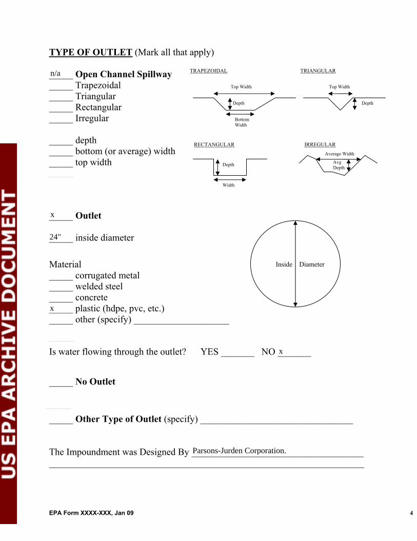
TYPE OF OUTLET (Mark all that apply)
TRAPEZOIDAL
Avg Depth
Bottom Width
Depth
TRIANGULAR_____ Open Channel Spillway_____ Trapezoidal Top Width Top Width
_____ Triangular
RECTANGULAR IRREGULAR
Depth _____ Rectangular _____ Irregular
_____ depth _____ bottom (or average) width
Width
Depth
Average Width
_____ top width
_____ Outlet
_____ inside diameter
Material Inside Diameter
_____ corrugated metal _____ welded steel _____ concrete _____ plastic (hdpe, pvc, etc.) _____ other (specify) ____________________
Is water flowing through the outlet? YES _______ NO _______
_____ No Outlet
_____ Other Type of Outlet (specify) ________________________________
The Impoundment was Designed By ______________________________________________________________________________________________________
EPA Form XXXX-XXX, Jan 09 4
n/a
x
24"
x
x
Parsons-Jurden Corporation.

Has there ever been a failure at this site? YES __________ NO ___________
If So When? ___________________________
If So Please Describe : _____________________________________________________________________________________________________________________________________________________________________________________________________________________________________________________________________________________________________________________________________________________________________________________________________________________________________________________________________________________________________________________________________________________________________________________________________________________________________________________________________________________________________________________________________________________________________________________________________________________________________________________________________________________________________________________________________________________________________________________________________________________________________________________________________________________________________________________________________________________________________________________________________________________________________________________________________________________________________________________________________________________________________________________________________________________________________________________________________________________________________________________________________________________________________________________________________________________________________________________________________________________________________________________________________________________________________________________________________________________________________________________________________________________________________________________________________________________________________________________________________________________________________________________________________________________________________________________________________________________________________________________________________________________________________________
EPA Form XXXX-XXX, Jan 09 5
x

Has there ever been significant seepages at this site? YES _______ NO _______
If So When? ___________________________
IF So Please Describe: _______________________________________________________________________________________________________________________________________________________________________________________________________________________________________________________________________________________________________________________________________________________________________________________________________________________________________________________________________________________________________________________________________________________________________________________________________________________________________________________________________________________________________________________________________________________________________________________________________________________________________________________________________________________________________________________________________________________________________________________________________________________________________________________________________________________________________________________________________________________________________________________________________________________________________________________________________________________________________________________________________________________________________________________________________________________________________________________________________________________________________________________________________________________________________________________________________________________________________________________________________________________________________________________________________________________________________________________________________________________________________________________________________________________________________________________________________________________________________________________________________________________________________________________________________________________________________________________________________________________________________________________________________________________________________________
EPA Form XXXX-XXX, Jan 09 6
x

Has there ever been any measures undertaken to monitor/lowerPhreatic water table levels based on past seepages or breaches at this site? YES ________NO ________
If so, which method (e.g., piezometers, gw pumping,...)? ____________________
If so Please Describe : ____________________________________________________________________________________________________________________________________________________________________________________________________________________________________________________________________________________________________________________________________________________________________________________________________________________________________________________________________________________________________________________________________________________________________________________________________________________________________________________________________________________________________________________________________________________________________________________________________________________________________________________________________________________________________________________________________________________________________________________________________________________________________________________________________________________________________________________________________________________________________________________________________________________________________________________________________________________________________________________________________________________________________________________________________________________________________________________________________________________________________________________________________________________________________________________________________________________________________________________________________________________________________________________________________________________________________________________________________________________________________________________________________________________________________________________________________________________________________________________________________________________________________________________________________________________________________________________________________________________________________________________________________________________________________________
EPA Form XXXX-XXX, Jan 09 7
x