Embed Size (px)
Citation preview

Local Traffic Committee Meeting
Monday, 18 February 2013
THE HILLS SHIRE CO
UNC
IL
LOCAL TRAFFIC COMMITTEE 18 February, 2013
PAGE 2
ITEM SUBJECT PAGE ITEM-1 CONFIRMATION OF MINUTES 3
ITEM-2 SOLENT CIRCUIT, BELLA VISTA - NO STOPPING RESTRICTIONS
9
ITEM-3 SEVEN HILLS ROAD, BAULKHAM HILLS - PROPOSED RELOCATION OF BUS STOP
11
ITEM-4 RAILWAY STREET, BAULKHAM HILLS - REQUEST FOR BUS STOPS ON RAILWAY STREET NEAR JENNER STREET INTERSECTION
14
ITEM-5 RIDGECROP DRIVE, CASTLE HILL - REVIEW OF REMOVAL OF 'NO PARKING' ZONE
16
ITEM-6 OAKES ROAD, CARLINGFORD - REQUEST FOR PARKING RESTRICTIONS
19
ITEM-7 COONARA AVENUE, WEST PENNANT HILLS - REQUEST FOR REMOVAL OF 'NO PARKING' RESTRICTIONS
22
ITEM-8 REACH FOR THE RAINBOW FUN RUN - CASTLE HILL
25
ITEM-9 RIDE TO RIVERSTONE - CHARITY BIKE RIDE 27

LOCAL TRAFFIC COMMITTEE 18 February, 2013
PAGE 3

LOCAL TRAFFIC COMMITTEE 18 February, 2013
PAGE 4
LOCAL TRAFFIC COMMITTEE 18 February, 2013
PAGE 5
LOCAL TRAFFIC COMMITTEE 18 February, 2013
PAGE 6
LOCAL TRAFFIC COMMITTEE 18 February, 2013
PAGE 7

LOCAL TRAFFIC COMMITTEE 18 February, 2013
PAGE 8

LOCAL TRAFFIC COMMITTEE 18 February, 2013
PAGE 9
ITEM-2 SOLENT CIRCUIT, BELLA VISTA - NO STOPPING RESTRICTIONS
THEME: Balanced Urban Growth
HILLS 2026 OUTCOME/S: BUG 1 I can get where I need to go.
COUNCIL STRATEGY/S: BUG 1.1 Facilitate the provision of integrated transport alternatives that link residents to their home, places of work and services and facilities.
ELECTORATE: BAULKHAM HILLS
AUTHOR: TRAINEE TRAFFIC ENGINEER
JAMES LAIDLER
RESPONSIBLE OFFICER: MANAGER – INFRASTRUCTURE PLANNING
ANDREW KING
REPORT
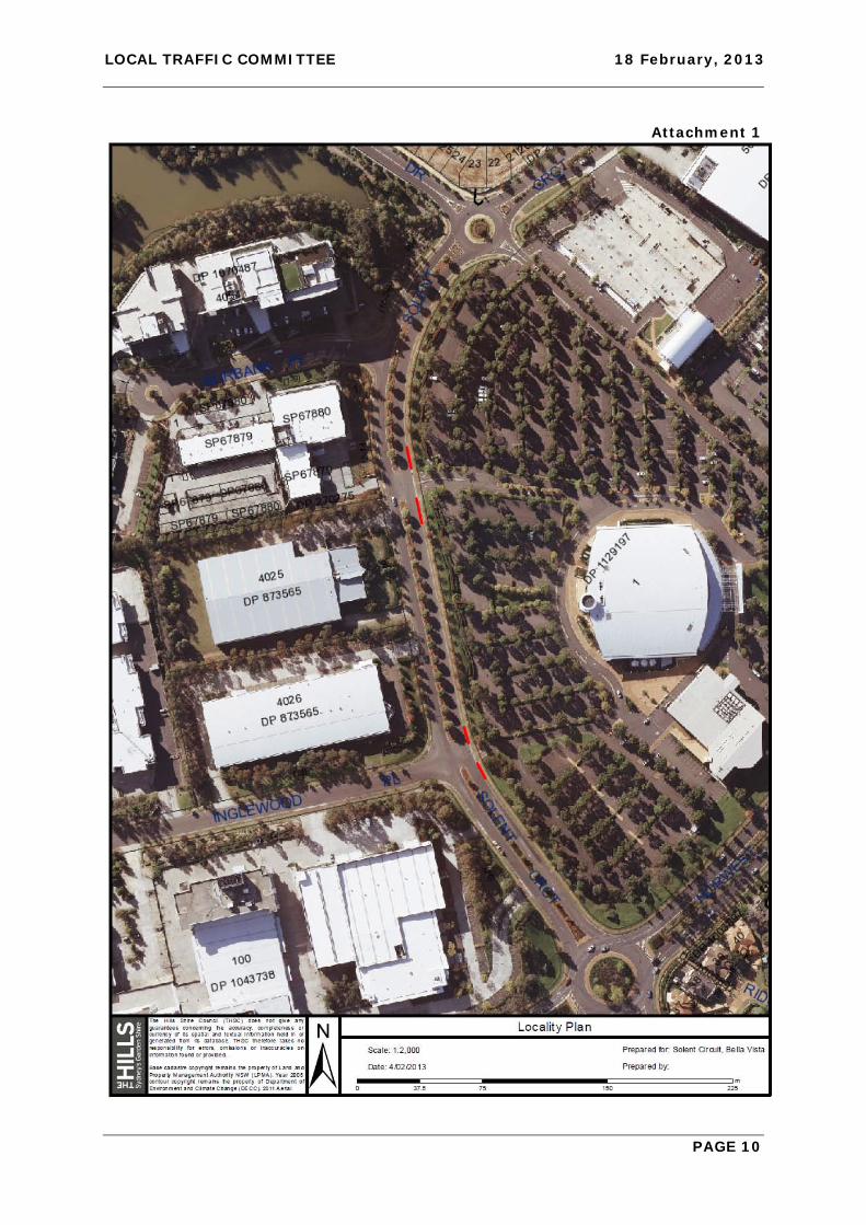
A representative of Hillsong Church has requested the installation of ‘No Stopping’ signs across both of its driveways located on the eastern side of Solent Circuit. The request is based on the difficulty experienced when exiting the driveways due to vehicles being parked on either side of the driveways reducing sight distance to oncoming vehicles to unacceptable levels. A number of s ite inspections have confirmed the Church’s observations. The Church has further requested that the Committee consider whether full time ‘No Stopping’ restrictions would be appropriate along the northern side of Solent Circuit between Inglewood Place and Norwest Boulevard to assist with traffic flow exiting Solent Circuit. Site inspections indicate that any vehicle parked in this location severely impedes the two lane traffic flow approaching Norwest Boulevard.
IMPACTS
Financial
Funding for signposting will be provided from Council’s existing signs and linemarking budget. Hills 2026 The recommendation of this report demonstrates Council’s aim of achieving a safer road network through the installation, renewal and modification of traffic facilities.
RECOMMENDATION
1. ‘No Stopping’ signs be installed for 20 metres either side of both driveways to Hillsong Church on Solent Circuit.
2. ‘No Stopping’ signs be installed on the northern side of Solent Circuit from Inglewood Place to Norwest Boulevard adjacent to the Church property.
ATTACHMENTS
1. Locality Plan
LOCAL TRAFFIC COMMITTEE 18 February, 2013
PAGE 10
Attachment 1
LOCAL TRAFFIC COMMITTEE 18 February, 2013
PAGE 11
ITEM-3 SEVEN HILLS ROAD, BAULKHAM HILLS - PROPOSED RELOCATION OF BUS STOP
THEME: Balanced Urban Growth
HILLS 2026 OUTCOME/S: BUG 1 I can get where I need to go.
COUNCIL STRATEGY/S: BUG 1.1 Facilitate the provision of integrated transport alternatives that link residents to their home, places of work and services and facilities.
ELECTORATE: BAULKHAM HILLS
AUTHOR: PRINCIPAL TRAFFIC & TRANSPORT COORDINATOR
STEPHEN BARNES
RESPONSIBLE OFFICER: MANAGER – INFRASTRUCTURE PLANNING
ANDREW KING
REPORT
As part of the ongoing construction of the traffic control signals at the intersection of Seven Hills Road and Baulkham Hills Road, the RMS have raised concerns regarding the location of an existing bus stop on the northern side of Seven Hills Road immediately west of Flinders Avenue fronting house numbers 123/125 Seven Hills Road. The existing location of the bus stop is immediately adjacent to the proposed right turn bay into Baulkham Hills Road. A bus stopped at this location would block east bound through traffic whilst picking up and dropping off passengers. In addition, the proximity of the existing stop line and signal post to the bus stop in Seven Hills Road impedes sight distance to the traffic signal lanterns for approaching east bound vehicles. The RM S h ave suggested to i mprove safety a nd re duce d elays f or t hrough v ehicle movements that the bus stop be relocated approximately 50 to 80 metres west o f the current location. Hillsbus have inspected the proposed location and are in concurrence to the proposal. Consultation with the affected property owners has yet to be undertaken however advice should be forthcoming prior to the Local Traffic Committee meeting on 18 February 2013. That information will be provided at the meeting.
IMPACTS
Financial This matter has no direct financial impact upon Council's adopted budget or forward estimates.
Hills 2026 The recommendation of this report demonstrates Council’s aim of achieving a safer road network through the installation, renewal and modification of traffic facilities.

LOCAL TRAFFIC COMMITTEE 18 February, 2013
PAGE 12
RECOMMENDATION
The proposed relocation of the existing bus stop in Seven Hills Road in the vicinity of Flinders Avenue be supported subject to no substantial objections from the affected property owners.
ATTACHMENTS
1. Locality Plan

LOCAL TRAFFIC COMMITTEE 18 February, 2013
PAGE 13
Attachment 1
LOCAL TRAFFIC COMMITTEE 18 February, 2013
PAGE 14
ITEM-4 RAILWAY STREET, BAULKHAM HILLS - REQUEST FOR BUS STOPS ON RAILWAY STREET NEAR JENNER STREET INTERSECTION
THEME: Balanced Urban Growth
HILLS 2026 OUTCOME/S: BUG 1 I can get where I need to go.
COUNCIL STRATEGY/S: BUG 1.1 Facilitate the provision of integrated transport alternatives that link residents to their home, places of work and services and facilities.
ELECTORATE: BAULKHAM HILLS
AUTHOR: TRAFFIC ENGINEER
MICHAEL DOYLE
RESPONSIBLE OFFICER: MANAGER – INFRASTRUCTURE PLANNING
ANDREW KING
REPORT
Council has received a request from a resident for the installation of a school bus zone on Railway Street near Jenner Street. The complaint is that whilst a school bus route utilises Railway Street there are no bus stops provided. As a result bus drivers often refuse to set down passengers in Railway Street. Discussions with bus company representatives indicated that drivers have been told to drop off or pick up school children as required. This instruction however in practice is difficult to achieve due to the level of on street parking often preventing a bus from pulling over clear of the through traffic lane. To facilitate the provision of bus stops a section of existing ‘No Stopping’ zone could be amended to ‘No Stopping at Other Times’ and ‘Bus Zone School Days 8:00am to 9:30am and 2:30pm to 4:00pm’ and installed on both sides of Railway Street at Jenner Street.
IMPACTS
Financial Funding will be provided from Council’s existing signposting and linemarking budget.
Hills 2026 The recommendation of this report demonstrates Council’s aim of achieving a safer road network through the installation, renewal and modification of traffic facilities.
RECOMMENDATION
Council install a ‘Bus Zone School Days 8:00am to 9:30am and 2:30pm to 4:00pm’ with ‘No Stopping at Other Times’ in the existing ‘No Stopping’ zones in Railway Street at Jenner Street.
ATTACHMENTS
1. Locality Plan

LOCAL TRAFFIC COMMITTEE 18 February, 2013
PAGE 15
Attachment 1

LOCAL TRAFFIC COMMITTEE 18 February, 2013
PAGE 16
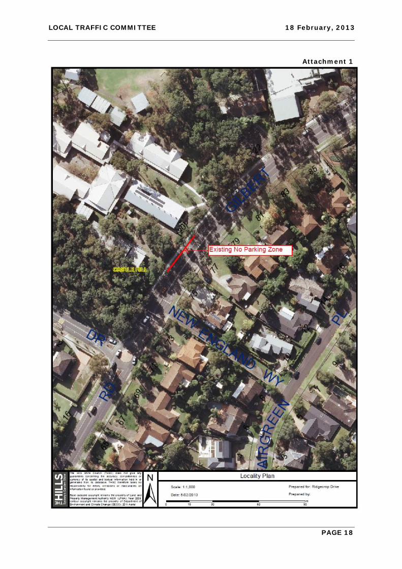
ITEM-5 RIDGECROP DRIVE, CASTLE HILL - REVIEW OF REMOVAL OF 'NO PARKING' ZONE
THEME: Balanced Urban Growth
HILLS 2026 OUTCOME/S: BUG 1 I can get where I need to go.
COUNCIL STRATEGY/S: BUG 1.1 Facilitate the provision of integrated transport alternatives that link residents to their home, places of work and services and facilities.
ELECTORATE: CASTLE HILL
AUTHOR: TRAFFIC ENGINEER
MICHAEL DOYLE
RESPONSIBLE OFFICER: MANAGER – INFRASTRUCTURE PLANNING
ANDREW KING
REPORT
Following a site inspection before the Local Traffic Committee meeting of 21 November 2011 the Committee made the recommendation below: “It was agreed at the site inspection that to improve traffic safety particularly with respect to conflicts at the school crossing, the existing “No Parking 8:00 to 9:30am and 2:30 to 4:00 pm School Days” applicable to the existing kiss and drop zone in Ridgecrop Drive fronting Samuel Gilbert Public School, be modified to apply during the morning peak period only for a trial period of 6 months effective from the first day of the 2012 school term.” The ‘No Parking’ zone was amended in accordance with the recommendation that was adopted by Council at its meeting on 13 December 2011. Unfortunately t here were delays experienced i n the obtaining o f f eedback f rom the P & C Association and these have now been obtained. The Principal of the school advised by letter that the removal of the afternoon kiss and drop zone improved the safety of both children and motorists as well as improving traffic flow o n Ri dgecrop D rive. T he P & C A ssociation a greed with th e P rincipal in t hat Ridgecrop Drive has improved greatly since the removal of the afternoon kiss and drop zone. Based on the above observations the removal of the kiss and drop zone has proven to be effective. It has been suggested that consideration be given to the removal of the existing ‘No Parking’ z one on G ilbert R oad n orth o f t he r oundabout to d eter s imilar p roblems occurring on Gilbert Road that has occurred on Ridgecrop Drive. Site inspections supported both the Principals and the P & C Association observations regarding the existing ‘No Parking’ on Gilbert Road. These restrictions could be removed to a llow full t ime unrestricted parking thus reducing the impact of vehicles queuing on Gilbert Road.

LOCAL TRAFFIC COMMITTEE 18 February, 2013
PAGE 17
IMPACTS
Financial Funding will be provided from Council’s existing signposting and linemarking budget.
Hills 2026 The recommendation of this report demonstrates Council’s aim of achieving a safer road network through the installation, renewal and modification of traffic facilities.
RECOMMENDATION
1. Council note the success of removing the k iss and drop zone at Samuel G ilbert Public School on Ridgecrop Drive.
2. Council remove the ‘No Parking’ zone on Gilbert Road immediately north of the roundabout at Ridgecrop Drive (south).
ATTACHMENTS
1. Locality Plan
LOCAL TRAFFIC COMMITTEE 18 February, 2013
PAGE 18
Attachment 1
LOCAL TRAFFIC COMMITTEE 18 February, 2013
PAGE 19
ITEM-6 OAKES ROAD, CARLINGFORD - REQUEST FOR PARKING RESTRICTIONS
THEME: Balanced Urban Growth
HILLS 2026 OUTCOME/S: BUG 1 I can get where I need to go.
COUNCIL STRATEGY/S: BUG 1.1 Facilitate the provision of integrated transport alternatives that link residents to their home, places of work and services and facilities.
ELECTORATE: CASTLE HILL
AUTHOR: TRAFFIC ENGINEER
MICHAEL DOYLE
RESPONSIBLE OFFICER: MANAGER – INRASTRUCTURE PLANNING
ANDREW KING
REPORT
Council has received a request from a resident of Oakes Road for parking restrictions at the driveway to number 47 indicating that motorists are parking up to the driveway and obstructing visibility when leaving their property. Site inspections reveal that commuter vehicles are parking on both sides of Oakes Road extending southerly from the M2. Sight distance on Oakes Road is further restricted due to its vertical alignment. Council is currently considering a commuter parking strategy that identifies areas where commuter parking could be provided. There are several parcels of land along the M2 corridor a t Carlingford that could potentially be used for such parking. These locations need to be further investigated prior to discussions with the State Government regarding funding. This may if implemented, reduce on street parking demand at this location. Council has received similar requests in the past from other residents of Oakes Road, Jenkins Road and adjoining side streets. However, agreement to signage at one driveway could potentially result in similar requests from other property owners. Also to provide sight d istance th at w ould b e a cceptable to a ll t he r esidents m ay result i n restrictions applying to the full length o f Oakes Road on both s ides of the s treet. This would increase demand for parking in the side streets in the vicinity or at other locations currently not affected by commuter parking. Any restrictions will need to apply equally to residents and visitors and need to be full time due to the parking demand at the M2 bus stop occurring on weekends and after hours. The p rovision o f p eriod p arking r estrictions a s u sed i n o ther s treets w ould n ot b e successful at this location. The shopkeepers at Carmen Drive have indicated that they needed additional restrictions later into the evening to prevent motorists parking in the time limited a rea p rior to i t f inishing a nd th en tr avelling into S ydney f or e xtended periods of time. Objections could also be anticipated as to which side of Oakes Road the restrictions should apply.
LOCAL TRAFFIC COMMITTEE 18 February, 2013
PAGE 20
CONCLUSION
Given the difficulties at this location, parking restrictions would need to be extensive and impact o n a large n umber of r esidents a nd c ommuters. Re strictions w ould d isplace commuter parking into other areas not currently impacted by commuter parking. Council should defer any decisions with respect to on street parking restrictions near the M2 until the outcome of the Hills Commuter Parking Strategy is known.
IMPACTS
Financial This matter has no direct financial impact upon Council's adopted budget or forward estimates.
Hills 2026 The recommendation of this report demonstrates Council’s aim of achieving a safer road network through the installation, renewal and modification of traffic facilities.
RECOMMENDATION
1. Council expedite t he Hills Commuter Carparking Strategy for the provision of additional car parking areas.
2. This matter be reviewed once the Hills Commuter Carparking Strategy is finalised.
ATTACHMENTS
1. Locality Plan

LOCAL TRAFFIC COMMITTEE 18 February, 2013
PAGE 21
Attachment 1
LOCAL TRAFFIC COMMITTEE 18 February, 2013
PAGE 22
ITEM-7 COONARA AVENUE, WEST PENNANT HILLS - REQUEST FOR REMOVAL OF 'NO PARKING' RESTRICTIONS
THEME: Balanced Urban Growth
HILLS 2026 OUTCOME/S: BUG 1 I can get where I need to go.
COUNCIL STRATEGY/S: BUG 1.1 Facilitate the provision of integrated transport alternatives that link residents to their home, places of work and services and facilities.
ELECTORATE: CASTLE HILL
AUTHOR: MANAGER – INFRASTRUCTURE PLANNING
ANDREW KING
RESPONSIBLE OFFICER: GROUP MANAGER – STRATEGIC PLANNING
MICHAEL EDGAR
REPORT
A resident of Coonara Avenue, West Pennant Hills has requested consideration be given to the removal o f th e e xisting ‘ No P arking 9 :00am to 4 :00pm Monday to F riday’ restrictions on the north western kerbline opposite the Coonara Avenue shops. These restrictions have been in place for an extended period of time and were introduced originally to deter employees of both the shops and IBM from parking on street. The resident advises that circumstances have changed and his family have additional vehicles and would benefit from being able to park on street. The removal of p arking restrictions would increase the possibility of all day parking returning to Coonara Avenue. Should this occur then complaints may be generated by other residents as parked vehicles can obstruct sight distance whilst attempting to enter or leave their driveways. The removal of parking r estrictions would increase the possibility of all day parking returning to Coonara Avenue. Should this occur then complaints may be generated by other residents as parked vehicles can obstruct sight distance whilst attempting to enter or leave their driveways. However the area in question involves the last two properties at the western end of the ‘No Parking’ signs opposite the shopping centre. Both of those residents have expressed the desire to remove approximately 30m of the restriction fronting their homes.
IMPACTS
Financial This matter has no direct financial impact upon Council's adopted budget or forward estimates.
Hills 2026 The recommendation of this report demonstrates Council’s aim of achieving a safer road network through the installation, renewal and modification of traffic facilities.

LOCAL TRAFFIC COMMITTEE 18 February, 2013
PAGE 23
RECOMMENDATION
The existing parking restrictions on the north western kerbline of Coonara Avenue be adjusted to remove 30m of ‘No Parking’ fronting house numbers 52 and 54.
ATTACHMENTS
1. Locality Plan

LOCAL TRAFFIC COMMITTEE 18 February, 2013
PAGE 24
Attachment 1
LOCAL TRAFFIC COMMITTEE 18 February, 2013
PAGE 25
ITEM-8 REACH FOR THE RAINBOW FUN RUN - CASTLE HILL
THEME: Balanced Urban Growth
HILLS 2026 OUTCOME/S: BUG 1 I can get where I need to go.
COUNCIL STRATEGY/S: BUG 1.1 Facilitate the provision of integrated transport alternatives that link residents to their home, places of work and services and facilities.
ELECTORATE: CASTLE HILL
AUTHOR: TRAFFIC ENGINEER
MICHAEL DOYLE
RESPONSIBLE OFFICER: MANAGER – INFRASTRUCTURE PLANNING
ANDREW KING
REPORT
IN October 2012 the charity Reach for the Ra inbow conducted i ts inaugural fun run to raise funds for disabled children. The event was conducted satisfactorily with little inconvenience to the wider community. It i s proposed to undertake the fun run again this year, nominally on the 16th October 2013. T here w ill h owever b e a s ingle s tart a nd f inish line d ue t o c onfusion with competitors having occurred l ast year. The start and f inish line will be i ndicated in the Traffic Management Plan. A copy of the Traffic Management Plan for the run will be tabled at the meeting for consideration.
IMPACTS
Financial This matter has no direct financial impact upon Council's adopted budget or forward estimates.
Hills 2026 The recommendation of this report demonstrates Council’s aim of achieving a safer road network through the installation, renewal and modification of traffic facilities.
RECOMMENDATION
Council give approval to the undertaking of the Reach for the Rainbow Fun Run in Castle Hill.
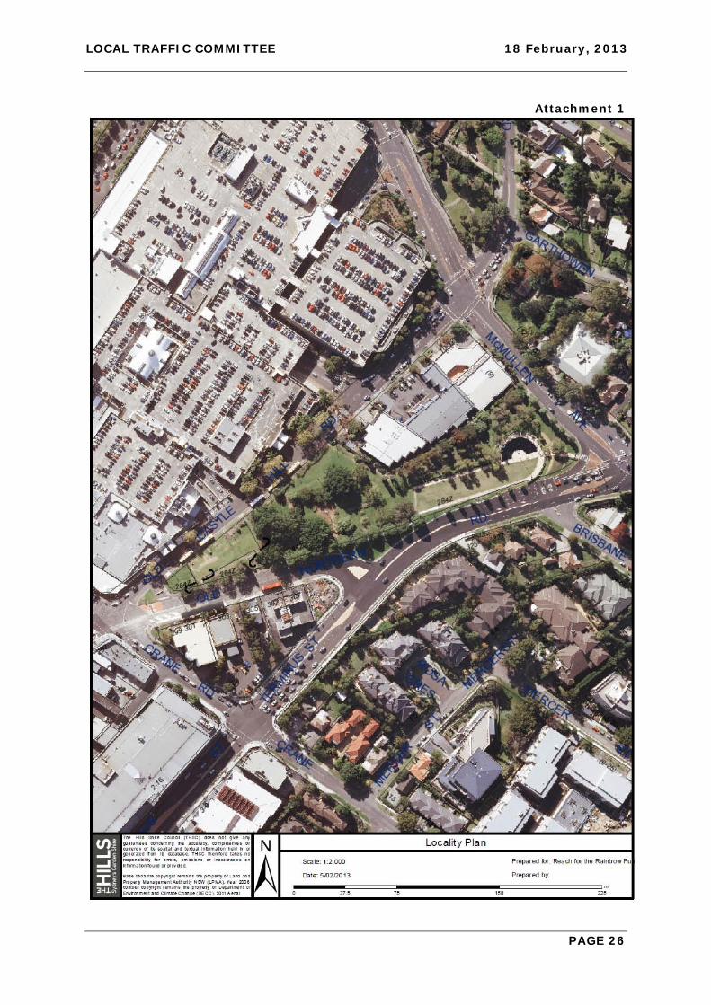
ATTACHMENTS
1. Locality Plan
LOCAL TRAFFIC COMMITTEE 18 February, 2013
PAGE 26
Attachment 1

LOCAL TRAFFIC COMMITTEE 18 February, 2013
PAGE 27
ITEM-9 RIDE TO RIVERSTONE - CHARITY BIKE RIDE
THEME: Balanced Urban Growth
HILLS 2026 OUTCOME/S: BUG 1 I can get where I need to go.
COUNCIL STRATEGY/S: BUG 1.1 Facilitate the provision of integrated transport alternatives that link residents to their home, places of work and services and facilities.
ELECTORATE: HAWKESBURY
AUTHOR: TRAFFIC ENGINEER
MICHAEL DOYLE
RESPONSIBLE OFFICER: MANAGER – INFRASTRUCTURE MANAGER
ANDREW KING
REPORT
The Lions Club of Riverstone proposes to undertake the annual fund raising bicycle ride ‘Ride to Riverstone’ on Sunday, 15th May 2013. The event is similar to previous years and involves the closure of Blue Gum Road and a speed reduction on Bannerman Road. This year however there are some minor alterations to the event from last year. To minimise the impact on Bannerman Road only the 30km and 100km routes will use Bannerman Road and it is anticipated that they will be clear of Bannerman Road by 9:30am. All details are attached to this report (Attachment 1). It is noted that the amended routes will result in Annangrove Road between Edwards Road and Blue Gum Road being used by cyclists in both directions and will need to have both the intersections with Anangrove Road being controlled by authorised traffic controllers.
IMPACTS
Financial This matter has no direct financial impact upon Council's adopted budget or forward estimates.
Hills 2026 The recommendation of this report demonstrates Council’s aim of achieving a safer road network through the installation, renewal and modification of traffic facilities.
RECOMMENDATION
Council g ive a pproval to th e ‘ Ride to Ri verstone C harity B ike R ide’ s ubject to t he concurrence of the Roads & Maritime Services and the Police Service.
ATTACHMENTS
1. Traffic Management Plan

LOCAL TRAFFIC COMMITTEE 18 February, 2013
PAGE 28
Attachment 1

LOCAL TRAFFIC COMMITTEE 18 February, 2013
PAGE 29

LOCAL TRAFFIC COMMITTEE 18 February, 2013
PAGE 30

LOCAL TRAFFIC COMMITTEE 18 February, 2013
PAGE 31

LOCAL TRAFFIC COMMITTEE 18 February, 2013
PAGE 32

LOCAL TRAFFIC COMMITTEE 18 February, 2013
PAGE 33
LOCAL TRAFFIC COMMITTEE 18 February, 2013
PAGE 34

LOCAL TRAFFIC COMMITTEE 18 February, 2013
PAGE 35

LOCAL TRAFFIC COMMITTEE 18 February, 2013
PAGE 36

LOCAL TRAFFIC COMMITTEE 18 February, 2013
PAGE 37

LOCAL TRAFFIC COMMITTEE 18 February, 2013
PAGE 38
LOCAL TRAFFIC COMMITTEE 18 February, 2013
PAGE 39

LOCAL TRAFFIC COMMITTEE 18 February, 2013
PAGE 40

LOCAL TRAFFIC COMMITTEE 18 February, 2013
PAGE 41