Embed Size (px)
Citation preview
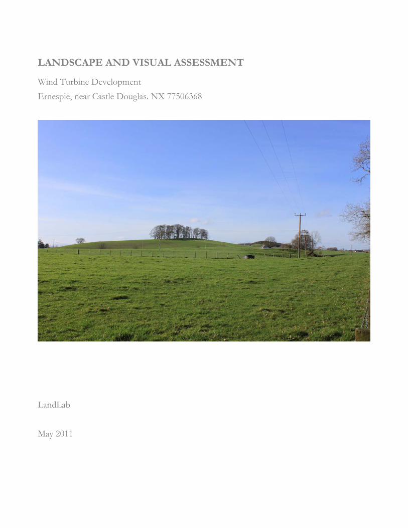
LANDSCAPE AND VISUAL ASSESSMENT
Wind Turbine Development Ernespie, near Castle Douglas. NX 77506368
andLab
ay 2011
L M

Ernespie M319/009/11
Revision History Revision Date Notes
Original, current 13 May 2011
© LandLab, May 2011 2

Contents A. SUMMARY REPORT....................................................................................................................................3
A.1. Introduction .................................................................................................................................................3 A.2. Summary of Significant Adverse Effects .................................................................................................4 A.3. Design Mitigation ........................................................................................................................................5 A.4. Assessment of Residual Landscape and Visual Effects .........................................................................5
B. ASSESSMENT.............................................................................................................................................. 15 B.1. Introduction .............................................................................................................................................. 15 B.2. The Study Area ......................................................................................................................................... 16 B.3. Description of proposed development ................................................................................................. 17 B.4. The Application Site................................................................................................................................. 17 B.5. Zone of Theoretical Visibility (ZTV) Analysis .................................................................................... 17 B.6. Landscape Character ................................................................................................................................ 18
B.6.1. Project Landscape Type ................................................................................................................. 19 B.6.2. Other Landscape Types.................................................................................................................. 19
B.7. SNH Natural Heritage Sensitivity Guidance ........................................................................................ 20 B.8. Designations.............................................................................................................................................. 20 B.9. Cumulative Effect..................................................................................................................................... 20 B.10. Route corridors and journeys through the landscape ......................................................................... 20 B.11. Viewpoint Assessment............................................................................................................................. 22
C. SCOPE AND METHOD........................................................................................................................... 25 C.1. Scope of the assessment .......................................................................................................................... 25
C.1.1. Pre application consultation........................................................................................................... 25 C.1.2. Potential Effects .............................................................................................................................. 25
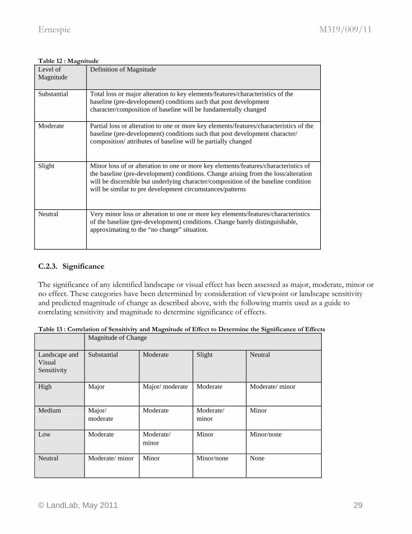
C.2. Method of Assessment ............................................................................................................................ 26 C.2.1. Sensitivity.......................................................................................................................................... 27 C.2.2. Magnitude ......................................................................................................................................... 28 C.2.3. Significance....................................................................................................................................... 29
C.3. Baseline Evaluation .................................................................................................................................. 30 C.3.1. Desk study ........................................................................................................................................ 30 C.3.2. Field survey....................................................................................................................................... 31
C.4. Landscape Character ................................................................................................................................ 31 C.5. SNH Natural Heritage Sensitivity Guidance ........................................................................................ 31 C.6. Designations.............................................................................................................................................. 32 C.7. Potential Cumulative Effects .................................................................................................................. 32 C.8. Route corridors and journeys through the landscape ......................................................................... 33 C.9. Viewpoint Assessment............................................................................................................................. 33 C.10. Significant Adverse Effects ..................................................................................................................... 34 C.11. Design Mitigation ..................................................................................................................................... 34
C.11.1. Micro siting....................................................................................................................................... 34 C.11.2. Colour finishes................................................................................................................................. 34
C.12. Assessment of Residual Landscape and Visual Effects ...................................................................... 35
Ernespie M319/009/11
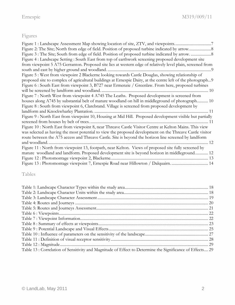
Figures Figure 1 : Landscape Assessment Map showing location of site, ZTV, and viewpoints....................................7 Figure 2: The Site; North from edge of field. Position of proposed turbine indicated by arrow......................8 Figure 3 : The Site; South from edge of field. Position of proposed turbine indicated by arrow. ....................8 Figure 4 : Landscape Setting : South East from top of earthwork screening proposed development site from viewpoint 5 A75 Gerranton. Proposed site lies at western edge of relatively level plain, screened from south and east by higher ground and woodland. ......................................................................................................9 Figure 5 : West from viewpoint 2 Blackerne looking towards Castle Douglas, showing relationship of proposed site to complex of agricultural buildings at Ernespie Dairy, at the centre left of the photograph...9 Figure 6 : South East from viewpoint 3, B727 near Ermenzie / Greenlaw. From here, proposed turbines will be screened by landform and woodland. ......................................................................................................... 10 Figure 7 : North West from viewpoint 4 A745 The Leaths. Proposed development is screened from houses along A745 by substantial belt of mature woodland on hill in middleground of photograph........... 10 Figure 8 : South from viewpoint 6, Clarebrand. Village is screened from proposed development by landform and Knockwharley Plantation. ................................................................................................................ 11 Figure 9 : North East from viewpoint 10, Housing at Mid Hill. Proposed development visible but partially screened from houses by belt of trees. .................................................................................................................... 11 Figure 10 : North East from viewpoint 8, near Threave Castle Visitor Centre at Kelton Mains. This view was selected as having the most potential to view the proposed development on the Threave Castle visitor route between the A75 access and Threave Castle. Site is beyond the horizon line screened by landform and woodland. ............................................................................................................................................................. 12 Figure 11 : North from viewpoint 13, footpath, near Kelton. Views of proposed site fully screened by mature woodland and landform. Proposed development site is beyond horizon in middleground............. 12 Figure 12 : Photomontage viewpoint 2, Blackerne................................................................................................ 13 Figure 13 : Photomontage viewpoint 7, Ernespie Road near Hillowton / Dalquairn. .................................... 14 Tables Table 1: Landscape Character Types within the study area.................................................................................. 18 Table 2: Landscape Character Units within the study area................................................................................... 18 Table 3: Landscape Character Assessment ............................................................................................................. 19 Table 4: Routes and Journeys ................................................................................................................................... 20 Table 5: Routes and Journeys Assessment.............................................................................................................. 21 Table 6 : Viewpoints................................................................................................................................................... 22 Table 7 : Viewpoint Information.............................................................................................................................. 22 Table 8 : Summary of effects at viewpoints............................................................................................................ 23 Table 9 : Potential Landscape and Visual Effects.................................................................................................. 25 Table 10 : Influence of parameters on the sensitivity of the landscape.............................................................. 27 Table 11 : Definition of visual receptor sensitivity................................................................................................ 28 Table 12 : Magnitude.................................................................................................................................................. 29 Table 13 : Correlation of Sensitivity and Magnitude of Effect to Determine the Significance of Effects.... 29
© LandLab, May 2011 2
Ernespie M319/009/11
A. SUMMARY REPORT
A.1. Introduction (The following is a summary. Please read Section B. for the full assessment, and Section C. for the scope and method adopted.) This study is a Landscape and Visual Assessment (LVA) in support of a planning application for a wind turbine development at Ernespie, near Castle Douglas, Dumfries and Galloway, Scotland. The study area for the assessment covers a five km radius from the centre of the proposed project. The LVA has been prepared by an experienced Chartered Landscape Architect (CMLI), a corporate member of the UK Landscape Institute qualified to exercise professional judgement when carrying out Landscape and Visual Impact Assessment work under the Environmental Impact Assessment (Scotland) Regulations 1999. The LVA is organised into three parts. This part (Part A) is a summary report, Part B is the detailed assessment, and Part C explains the scope, methodology and terms of reference. The proposed development comprises one C&F Green Energy CF50 wind turbine, rated power output 50kW. The tower type is a 29.6 metre monopole in a plain galvanised finish, with a three blade, 20 metre diameter rotor. The site is located a reasonable distance away from settlements and has been chosen for its technical capacity to support a small scale wind turbine development. Relevant features of the site are
• Location in improved grassland pasture at the western edge of a rolling plain fringed by low hills and woodland
• Location in Drumlin Pastures Landscape Type; complex topography combined with vegetation cover restricts long views over the landscape, except from hill tops
• Dense belts of mature mixed woodland within 500m to the North, South and West
• Ordered and managed modern farming landscape where strong human influence is current and evident
• Development forms part of Ernespie Dairy, an extensive complex of large scale structures related to intensive agriculture
• Surrounding higher ground to the North and West has potential to limit views of development against the skyline, and screen views of the development from these directions.
Photographs of the site are provided below.
© LandLab, May 2011 3
Ernespie M319/009/11
A.2. Summary of Significant Adverse Effects (The following is a summary. Please read Section B. for the full assessment, and Section C. for the scope and method adopted.) The extent of potential visibility of the proposed development is shown to be well contained, given the height of proposed turbine and the locally exposed location. The site lies in an open rolling plain that is level relative to the overall height of the proposed development. The level plain is punctuated by numerous low lying Drumlins that break up visibility, enclose the open landscape and shorten views. The ZTV map shows the potential visibility of the proposed development to be a patchwork influenced by the disruption of long views by the Drumlins. No potential significant adverse effects on the landscape character are noted. At Ernespie the landscape conforms to the description of LCT13 Drumlin Pastures. Photographs of the landscape setting of the development are provided below. The Project Landscape Type is the landscape surrounding the proposed location of the development. At Ernespie the landscape conforms to the description of LCT13 Drumlin Pastures, Landscape Unit Milton, code: Mil. There a is a concentration on large scale agricultural infrastructure at Ernespie Dairy, with changes to the wider landscape as a consequence of the necessary adoption of intensive agricultural practices, such as improved grassland, the use of robust ‘armco’ style barriers, and construction of access roads and yards for large vehicles and plant. There are similar dairy farming developments locally at Ernespie Farm, Hillowton, Blackerne, Gerranton, The Leaths and Chapmanton. The proposed site lies on the northern edge of Castle Douglas, comprising medium scale developments such as Tesco, Station Yard Industrial Estate, the Urr Valley Hotel, and the Cattle Market. Close by, to the North of the site, lies the A75 trunk road, a major large scale development bypassing Castle Douglas, one of the larger transport infrastructure projects in the region that has a major influence on the character and quality of the landscape. To the South East the uncompromising modern architecture of the secondary school and a large telecommunications mast, a stark, utilitarian structure, are very prominent features in the landscape and dominate views from this direction. Closer, new domestic development and a new medium scale health centre have extended the urban character of Castle Douglas town northward. Although the proposed development is not intervisible with all the developments described, it is considered that the experience of the landscape to the North of Castle Douglas has been strongly influenced by a process of urbanisation that has changed the landscape character significantly. Although features of LCT13 Drumlin Pastures remain, the character of the landscape is strongly ‘urban fringe’ in character and therefore not sensitive to the location of a small to medium scale wind turbine development. The magnitude of change is considered to be neutral to slight because of its setting in a peri-urban landscape. The proposed development site lies within SNH Natural Heritage Sensitivity Guidance Zone 1: Lowest natural heritage sensitivity identifies areas at the broad scale with least sensitivity to wind farms, with the greatest opportunity for development. The proposed location is in accordance with SNH Policy Statement 01/02 Renewable Energy “there is likely to be a need to accept change in some of Scotland’s landscapes, which should be guided to landscapes which are already developed or noticeably modified and relatively close to centres of population.”
© LandLab, May 2011 4
Ernespie M319/009/11
No potential significant adverse effects on statutory or non-statutory landscape designations are noted. Threave Castle does not lie within the ZTV of the proposed development. No potential cumulative effects were identified as concerns at pre application consultation. No potential significant adverse effects on routes are noted. National Cycle Route (NCN) 7 is a nationally recognised tourist route and therefore has a high sensitivity to landscape change. The magnitude of change is considered to be slight to neutral because of the local setting of NCN7 in a peri – urban landscape on the approach to Castle Douglas. Although the the A75 passes close to the North, the visual experience in the A75 corridor is not considered to be significantly affected. No significant visual impacts are noted. Twenty two viewpoints were assessed. Overall the potential adverse effects of the proposed development on the visual experience of the landscape are considered to be moderate.
A.3. Design Mitigation No potential significant adverse effects are noted. No design mitigation is required.
A.4. Assessment of Residual Landscape and Visual Effects Overall, the potential effects of the proposed development on the landscape and available views of the landscape, and the significance of those effects on people is considered to be moderate / minor, and therefore acceptable. The landscape change identified in the assessment is not necessarily negative and may be positive when considered against objective design criteria rather than subjective values. Reasons The project will have no potential significant effects on the visual amenity of the twenty two viewpoints and nine routes included in the assessment. The landscape character is of a medium scale. The proposed development is also medium scale, in keeping with existing features surrounding the site. The relationship of scale and composition between the turbine, the rolling plain, woodland and agricultural buildings at Ernespie Dairy is considered to be balanced. The proposed turbines would not diminish the perceived scale of the hillside and would not overwhelm or ‘flatten’ the undulating landforms of the Drumlin Pastures landscape type. The experience of the landscape to the North of Castle Douglas has been strongly influenced by a process of urbanisation that has changed the landscape character significantly. Although features of LCT13 Drumlin Pastures remain, the character of the landscape is peri-urban in character and therefore not sensitive to the location of a small to medium scale wind turbine development. The proposed location is in accordance with SNH Policy Statement 01/02 Renewable Energy
© LandLab, May 2011 5

Ernespie M319/009/11
“there is likely to be a need to accept change in some of Scotland’s landscapes, which should be guided to landscapes which are already developed or noticeably modified and relatively close to centres of population.” The proposed wind turbines are not permanent structures. At the end of their useful life the above ground components of the turbines are decommissioned and removed from site, and the land returned to pasture. All residual effects are therefore considered to be long-term, but reversible.
© LandLab, May 2011 6
Ernespie M319/009/11
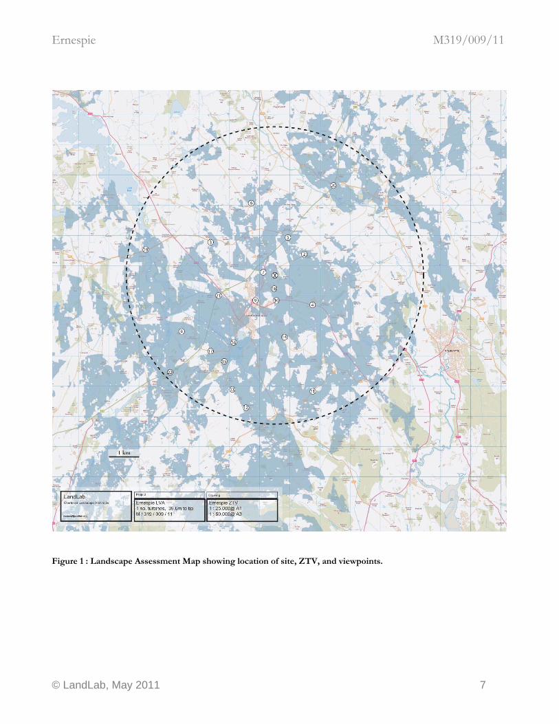
igure 1 : Landscape Assessment Map showing location of site, ZTV, and viewpoints.
F
© LandLab, May 2011 7

Ernespie M319/009/11
Figure 2: The Site; North from edge of field. Position of proposed turbine indicated by arrow.
site
Figure 3 : The Site; South from edge of field. Position of proposed turbine indicated by arrow.
site
© LandLab, May 2011 8

Ernespie M319/009/11
Figure 4 : Landscape Setting : South East from top of earthwork screening proposed development site from viewpoint 5 A75 Gerranton. Proposed site lies at western edge of relatively level plain, screened from south and east by higher ground and woodland.
site
Figure 5 : West from viewpoint 2 Blackerne looking towards Castle Douglas, showing relationship of proposed site to complex of agricultural buildings at Ernespie Dairy, at the centre left of the photograph.
site
© LandLab, May 2011 9
Ernespie M319/009/11
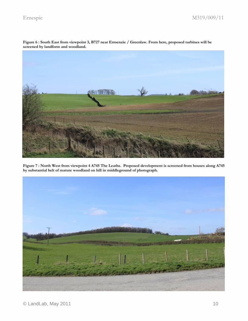
Figure 6 : South East from viewpoint 3, B727 near Ermenzie / Greenlaw. From here, proposed turbines will be screened by landform and woodland.
site
Figure 7 : North West from viewpoint 4 A745 The Leaths. Proposed development is screened from houses along A745 by substantial belt of mature woodland on hill in middleground of photograph.
© LandLab, May 2011 10
Ernespie M319/009/11
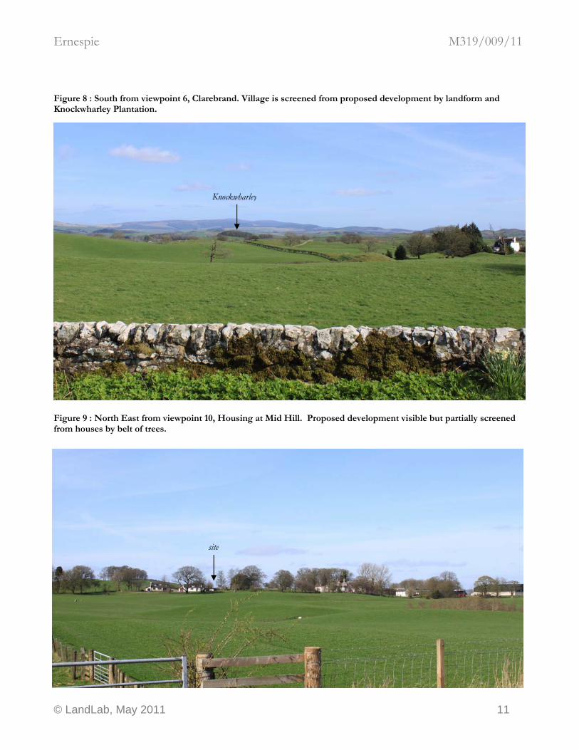
Figure 8 : South from viewpoint 6, Clarebrand. Village is screened from proposed development by landform and Knockwharley Plantation.
Knockwharley
Figure 9 : North East from viewpoint 10, Housing at Mid Hill. Proposed development visible but partially screened from houses by belt of trees.
site
© LandLab, May 2011 11
Ernespie M319/009/11
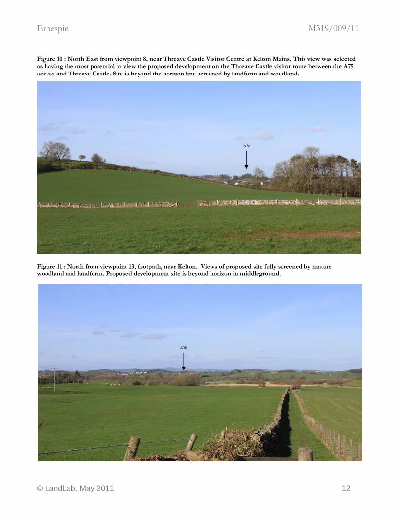
Figure 10 : North East from viewpoint 8, near Threave Castle Visitor Centre at Kelton Mains. This view was selected as having the most potential to view the proposed development on the Threave Castle visitor route between the A75 access and Threave Castle. Site is beyond the horizon line screened by landform and woodland.
site
Figure 11 : North from viewpoint 13, footpath, near Kelton. Views of proposed site fully screened by mature woodland and landform. Proposed development site is beyond horizon in middleground.
site
© LandLab, May 2011 12
Ernespie M319/009/11
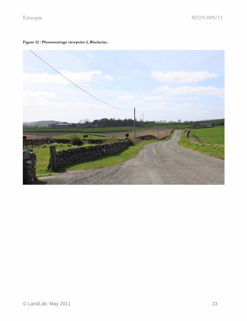
Figure 12 : Photomontage viewpoint 2, Blackerne.
© LandLab, May 2011 13
Ernespie M319/009/11
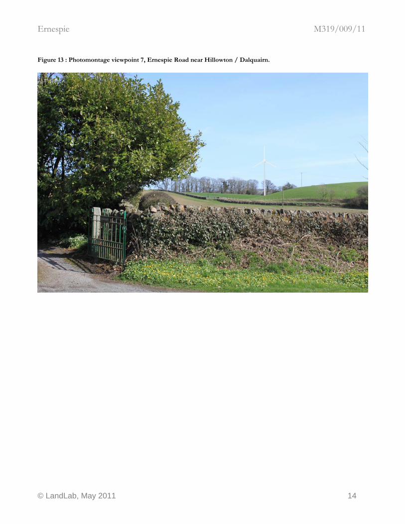
Figure 13 : Photomontage viewpoint 7, Ernespie Road near Hillowton / Dalquairn.
© LandLab, May 2011 14
Ernespie M319/009/11
B. ASSESSMENT
B.1. Introduction This study is a Landscape and Visual Assessment (LVA) in support of a planning application for a wind turbine development at Ernespie, near Castle Douglas, Dumfries and Galloway, Scotland. The scope, extent and detail of the study is considered to provide sufficient information to determine the application for the scale and complexity of the development proposed. The LVA has been prepared by an experienced Chartered Landscape Architect (CMLI), a corporate member of the UK Landscape Institute qualified to exercise professional judgement when carrying out Landscape and Visual Impact Assessment work under the Environmental Impact Assessment (Scotland) Regulations 1999. However, this study does not comprise a component of a formal Environmental Statement as defined in Regulations. This LVA is organised into three parts. Part A provides a summary report comprising
• summary description of the baseline landscape and visual resources of the application site and study area
• summary of the ZTV analysis and baseline evaluation
• a description of any proposed design mitigation measures incorporated at the design stage aimed at reducing or minimising potential landscape and visual effects
• in conclusion, an assessment of residual landscape and visual effects
• ZTV map and photographs
Part B provides the assessment, comprising
• a detailed description of the baseline landscape and visual resources of the application site and study area
• ZTV analysis
• Detailed baseline evaluation
Part C provides a summary explanation of how the scope of the assessment was defined and a description of the methodology used for the assessment. The methodology has been specially developed for domestic and small commercial developments of up to five turbines of not more than 40 metres to tip height. This LVA has been prepared as a tool to assist in the development of proposals using an iterative design process, and forms part of a group of documents in support of the planning application. The LVA aims to:
© LandLab, May 2011 15
Ernespie M319/009/11
• identify systematically all the potential landscape and visual impacts of the development taking account of the proposed mitigation measures,
• predict and estimate their magnitude as accurately as possible and
• assess their significance in a logical and reasoned manner.
The assessment describes the changes in the character and quality of the landscape and visual resources that are expected to result from the proposed development. It covers both landscape impacts, that is, changes in the fabric, character and key defining characteristics of the landscape and visual impacts, and changes in available views of the landscape and the significance of those changes on people. The LVA is prepared in accordance with the Guidelines for Landscape and Visual Impact Assessment (2nd Edition) 2002. (GLVIA). Landscape and visual assessment is concerned with both landscape and visual effects. Although landscape and visual effects are assessed and presented separately, these assessments are complementary and interdependent parts of a single study. Landscape effects derive from changes to the land, which may give rise to changes in its character and how this is experienced. This may in turn affect the perceived value ascribed to the landscape. The description and analysis of effects on a landscape resource relies on the adoption of certain basic principles about the positive (or beneficial) or negative (or adverse) effects of change in the landscape. Due to the inherently dynamic nature of the landscape, change arising from a development may not necessarily be significant. Visual effects relate to the changes that arise in the composition of available views as a result of changes to the land, to people’s responses to the changes, and to the overall effects with respect to visual amenity. (GLVIA, p12, 2.14, 1.15) Landscape character is a specific concept in landscape planning. Landscape effects are assessed by the identification and evaluation of landscape character, and by considering the effects that the proposed development may have on the landscape character. The effects on visual amenity are assessed by the definition of a Zone of Theoretical Visibility (ZTV) for the proposed development, the identification of selected, representative or important viewpoints within the ZTV, and by considering the effects that the proposed development may have on the views. The overall effect on the visual amenity is assessed by considering the likely effects on all potential views, based on the assessment of effects from the selected viewpoints.
B.2. The Study Area The site is located at Ernespie, Dumfries and Galloway, Scotland. The study area for the assessment covers a five km radius study area from the centre of the proposed project, from Clarebrand to the north, Dalbeattie to the east, Gelston to the south and Castle Douglas to the west. The study area is shown at Figure 1.
© LandLab, May 2011 16
Ernespie M319/009/11
B.3. Description of proposed development The proposed development comprises one C&F Green Energy CF50 wind turbine, rated power output 50kW. The tower type is a 29.6 metre monopole in a plain galvanised finish, with a three blade, 20 metre diameter rotor. The finished colour of the nacelle and rotor is white. Basic design information for proposed wind turbines is provided in the planning application documentation. The siting has been determined by a wide range of constraints, including potential landscape and visual impact. The viable area available to locate the turbines is provided in the planning application documentation. Within this area, micrositing may be possible, which may have an application in the mitigation of landscape and visual effects at a detailed level.
B.4. The Application Site The site is located a reasonable distance away from settlements and has been chosen for its technical capacity to support a small scale wind turbine development. The centre of the project site is located at approx NX 77506368. A plan of the immediate site context is in the planning application documentation. Relevant features of the site are
• Location in improved grassland pasture at the western edge of a rolling plain fringed by low hills and woodland
• Location in Drumlin Pastures Landscape Type; complex topography combined with vegetation cover restricts long views over the landscape, except from hill tops
• Dense belts of mature mixed woodland within 500m to the North, South and West
• Ordered and managed modern farming landscape where strong human influence is current and evident
• Development forms part of Ernespie Dairy, an extensive complex of large scale structures related to intensive agriculture
• Surrounding higher ground to the North and West has potential to limit views of development against the skyline, and screen views of the development from these directions.
Photographs of the site are provided above.
B.5. Zone of Theoretical Visibility (ZTV) Analysis The ZTV analysis map is provided at Figure 1. The area shaded blue represents the Zone of Theoretical Visibility. The extent of potential visibility of the proposed development is shown to be well contained, given the height of proposed turbine and the locally exposed location. The topography of the local landscape types are complex, and this combined with other landscape features such as woodland disrupts long views, except from prominent hilltops.
© LandLab, May 2011 17
Ernespie M319/009/11
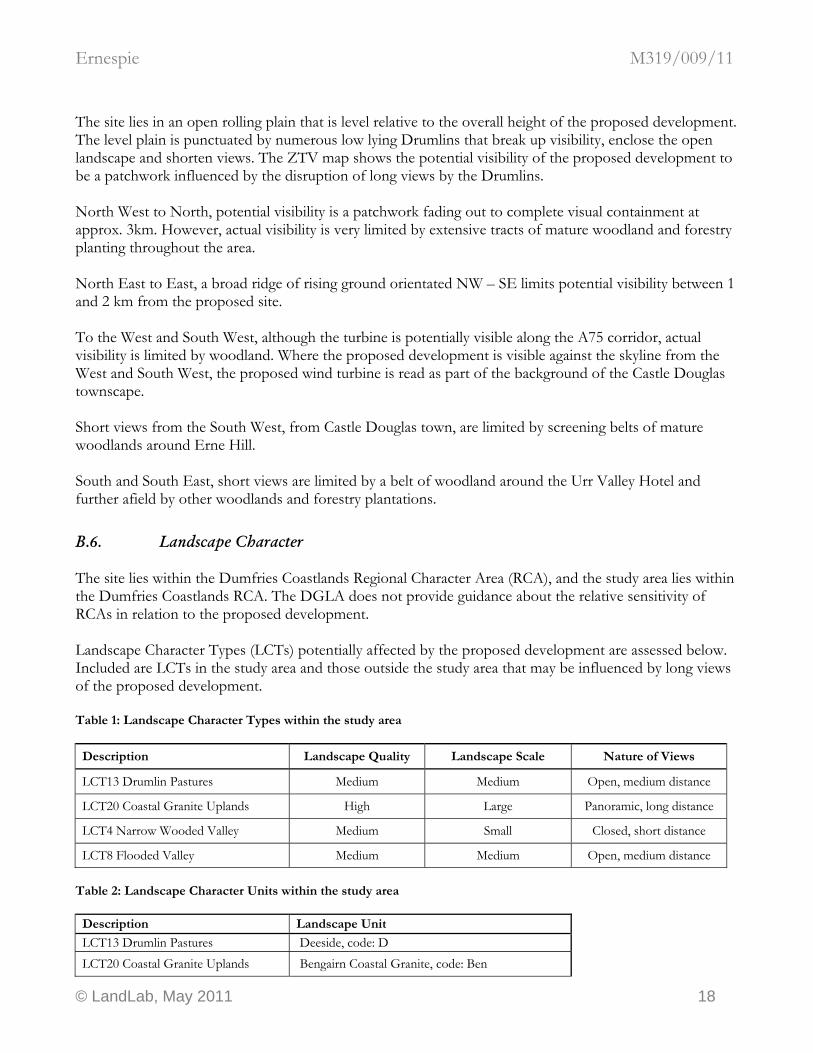
The site lies in an open rolling plain that is level relative to the overall height of the proposed development. The level plain is punctuated by numerous low lying Drumlins that break up visibility, enclose the open landscape and shorten views. The ZTV map shows the potential visibility of the proposed development to be a patchwork influenced by the disruption of long views by the Drumlins. North West to North, potential visibility is a patchwork fading out to complete visual containment at approx. 3km. However, actual visibility is very limited by extensive tracts of mature woodland and forestry planting throughout the area. North East to East, a broad ridge of rising ground orientated NW – SE limits potential visibility between 1 and 2 km from the proposed site. To the West and South West, although the turbine is potentially visible along the A75 corridor, actual visibility is limited by woodland. Where the proposed development is visible against the skyline from the West and South West, the proposed wind turbine is read as part of the background of the Castle Douglas townscape. Short views from the South West, from Castle Douglas town, are limited by screening belts of mature woodlands around Erne Hill. South and South East, short views are limited by a belt of woodland around the Urr Valley Hotel and further afield by other woodlands and forestry plantations.
B.6. Landscape Character The site lies within the Dumfries Coastlands Regional Character Area (RCA), and the study area lies within the Dumfries Coastlands RCA. The DGLA does not provide guidance about the relative sensitivity of RCAs in relation to the proposed development. Landscape Character Types (LCTs) potentially affected by the proposed development are assessed below. Included are LCTs in the study area and those outside the study area that may be influenced by long views of the proposed development. Table 1: Landscape Character Types within the study area
Description Landscape Quality Landscape Scale Nature of Views
LCT13 Drumlin Pastures Medium Medium Open, medium distance
LCT20 Coastal Granite Uplands High Large Panoramic, long distance
LCT4 Narrow Wooded Valley Medium Small Closed, short distance
LCT8 Flooded Valley Medium Medium Open, medium distance Table 2: Landscape Character Units within the study area
Description Landscape Unit
LCT13 Drumlin Pastures Deeside, code: D LCT20 Coastal Granite Uplands Bengairn Coastal Granite, code: Ben
© LandLab, May 2011 18
Ernespie M319/009/11
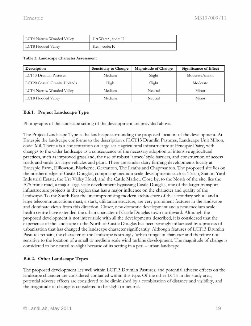
LCT4 Narrow Wooded Valley Urr Water , code: U
LCT8 Flooded Valley Ken , code: K
Table 3: Landscape Character Assessment
Description Sensitivity to Change Magnitude of Change Significance of Effect
LCT13 Drumlin Pastures Medium Slight Moderate/minor
LCT20 Coastal Granite Uplands High Slight Moderate
LCT4 Narrow Wooded Valley Medium Neutral Minor
LCT8 Flooded Valley Medium Neutral Minor
B.6.1. Project Landscape Type Photographs of the landscape setting of the development are provided above. The Project Landscape Type is the landscape surrounding the proposed location of the development. At Ernespie the landscape conforms to the description of LCT13 Drumlin Pastures, Landscape Unit Milton, code: Mil. There a is a concentration on large scale agricultural infrastructure at Ernespie Dairy, with changes to the wider landscape as a consequence of the necessary adoption of intensive agricultural practices, such as improved grassland, the use of robust ‘armco’ style barriers, and construction of access roads and yards for large vehicles and plant. There are similar dairy farming developments locally at Ernespie Farm, Hillowton, Blackerne, Gerranton, The Leaths and Chapmanton. The proposed site lies on the northern edge of Castle Douglas, comprising medium scale developments such as Tesco, Station Yard Industrial Estate, the Urr Valley Hotel, and the Cattle Market. Close by, to the North of the site, lies the A75 trunk road, a major large scale development bypassing Castle Douglas, one of the larger transport infrastructure projects in the region that has a major influence on the character and quality of the landscape. To the South East the uncompromising modern architecture of the secondary school and a large telecommunications mast, a stark, utilitarian structure, are very prominent features in the landscape and dominate views from this direction. Closer, new domestic development and a new medium scale health centre have extended the urban character of Castle Douglas town northward. Although the proposed development is not intervisible with all the developments described, it is considered that the experience of the landscape to the North of Castle Douglas has been strongly influenced by a process of urbanisation that has changed the landscape character significantly. Although features of LCT13 Drumlin Pastures remain, the character of the landscape is strongly ‘urban fringe’ in character and therefore not sensitive to the location of a small to medium scale wind turbine development. The magnitude of change is considered to be neutral to slight because of its setting in a peri – urban landscape.
B.6.2. Other Landscape Types The proposed development lies well within LCT13 Drumlin Pastures, and potential adverse effects on the landscape character are considered contained within this type. Of the other LCTs in the study area, potential adverse effects are considered to be diminished by a combination of distance and visibility, and the magnitude of change is considered to be slight or neutral.
© LandLab, May 2011 19
Ernespie M319/009/11
B.7. SNH Natural Heritage Sensitivity Guidance SNH provides a Scotland wide map showing areas of natural heritage sensitivity to windfarms. This map combines the landscape, recreation, biodiversity and earth science sensitivities to provide an overview of natural heritage sensitivity to wind farms. It identifies land with the greatest opportunity for wind farm development in natural heritage terms. The proposed development site lies within Zone 1: Lowest natural heritage sensitivity identifies areas at the broad scale with least sensitivity to wind farms, with the greatest opportunity for development, within which overall a large number of developments could be acceptable in natural heritage terms, so long as they are undertaken sensitively and with due regard to cumulative impact. Further, the proposed location is in accordance with SNH Policy Statement 01/02 Renewable Energy “there is likely to be a need to accept change in some of Scotland’s landscapes, which should be guided to landscapes which are already developed or noticeably modified and relatively close to centres of population.”
B.8. Designations No designations were identified as concerns at pre application consultation. Landscape and visual impacts on Listed Buildings and Scheduled Ancient Monuments have been incorporated into assessment of viewpoints and sections on landscape character. Threave Castle does not lie within the ZTV of the proposed development.
B.9. Cumulative Effect No potential cumulative effects were identified as concerns at pre application consultation.
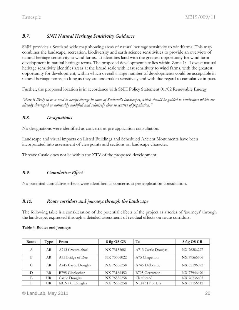
B.10. Route corridors and journeys through the landscape The following table is a consideration of the potential effects of the project as a series of ‘journeys’ through the landscape, expressed through a detailed assessment of residual effects on route corridors. Table 4: Routes and Journeys
Route Type From 8 fig OS GR To 8 fig OS GR
A AR A713 Crossmichael NX 73136681 A713 Castle Douglas NX 76286227
B AR A75 Bridge of Dee NX 73306022 A75 Chapelton NX 79566706
C AR A745 Castle Douglas NX 76556258 A745 Dalbeattie NX 82196072
D BR B795 Glenlochar NX 73186452 B795 Gerranton NX 77946490 E UR Castle Douglas NX 76556258 Clarebrand NX 76736603 F UR NCN7 C' Douglas NX 76556258 NCN7 H' of Urr NX 81156612
© LandLab, May 2011 20

Ernespie M319/009/11
G UR Leaths NX 78756269 Gerranton NX 77946490 H UR Castle Douglas NX 76556258 Craigton NX 79486068 I BR B727 Buittle NX 80426030 B727 Gelston NX 76985867 J BR B737 Gelston NX 76985867 B737 Castle Douglas NX 76556258 K UR Gelston NX 76985867 Threave NX 75826123 L UR B736 Threave NX 75066132 Castle Douglas NX 76556258
Table 5: Routes and Journeys Assessment
Route Description Sensitivity to Change Magnitude of Change Significance of Effect
A A713 Crossmichael to A713 Castle Douglas Low Slight Minor
B A75 Bridge of Dee to A75 Chapelton Low Moderate Moderate/minor
C A745 Castle Douglas to A745 Dalbeattie Low Slight Minor
D B795 Glenlochar to B795 Gerranton Medium Slight Moderate/minor E Castle Douglas to Clarebrand Medium Neutral Minor
F NCN7 C' Douglas to NCN7 H' of Urr High Slight Moderate
G Leaths to Gerranton Medium Slight Moderate/minor H Castle Douglas to Craigton Medium Slight Moderate/minor I B727 Buittle to B727 Gelston Medium Neutral Minor J B737 Gelston to B737 Castle Douglas Medium Slight Moderate/minor K Gelston to Threave Medium Slight Moderate/minor L B736 Threave to Castle Douglas Medium Neutral Minor
Only the routes and journeys relevant to this LVA are shown above. National Cycle Route (NCN) 7 is a nationally recognised tourist route and therefore has a high sensitivity to landscape change. The magnitude of change is considered to be slight to neutral because of the local setting of NCN7 in a peri – urban landscape on the approach to Castle Douglas. The site lies in close proximity to the A75. North and North West within 1km, a low range of wooded Drumlins screens the proposed development from the A75 corridor. North East, a 4 mere high linear earthwork running parallel with the A75 screens the proposed development from the A75 corridor around Gerranton and the junction with the B795. The screening effect of this landform is not accounted for in the ZTV analysis because the digital terrain model used to generate the ZTV has a height resolution of 5 metres. To the West and South West, although the turbine is potentially visible along the A75 corridor, actual visibility is limited by woodland, particularly on Drumlin summits. Where the proposed development is visible from the West and South West, the proposed wind turbine is read as part of the background to the Castle Douglas townscape. Overall, the potential adverse effects upon the journey experiences along route corridors within the study are considered to be moderate / minor, expressed as localised and static occurrences along the routes. These occurrences are covered in the sample of key viewpoints assessed below.
© LandLab, May 2011 21
Ernespie M319/009/11
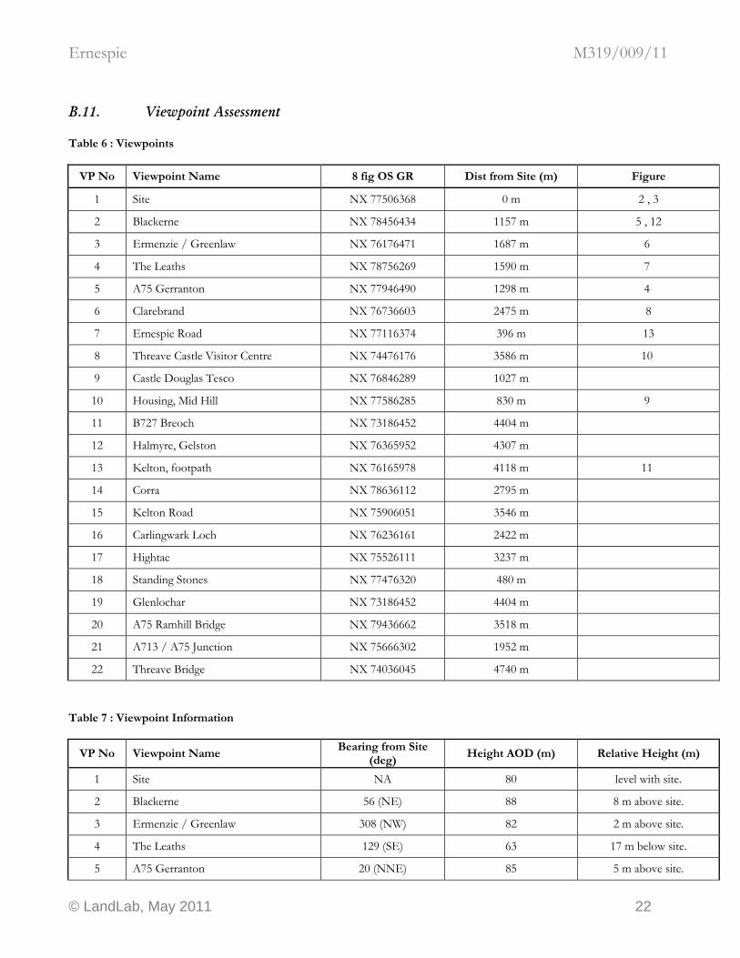
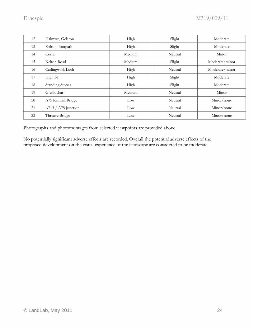
B.11. Viewpoint Assessment Table 6 : Viewpoints
VP No Viewpoint Name 8 fig OS GR Dist from Site (m) Figure
1 Site NX 77506368 0 m 2 , 3
2 Blackerne NX 78456434 1157 m 5 , 12
3 Ermenzie / Greenlaw NX 76176471 1687 m 6
4 The Leaths NX 78756269 1590 m 7
5 A75 Gerranton NX 77946490 1298 m 4
6 Clarebrand NX 76736603 2475 m 8
7 Ernespie Road NX 77116374 396 m 13
8 Threave Castle Visitor Centre NX 74476176 3586 m 10
9 Castle Douglas Tesco NX 76846289 1027 m
10 Housing, Mid Hill NX 77586285 830 m 9
11 B727 Breoch NX 73186452 4404 m
12 Halmyre, Gelston NX 76365952 4307 m
13 Kelton, footpath NX 76165978 4118 m 11
14 Corra NX 78636112 2795 m
15 Kelton Road NX 75906051 3546 m
16 Carlingwark Loch NX 76236161 2422 m
17 Hightae NX 75526111 3237 m
18 Standing Stones NX 77476320 480 m
19 Glenlochar NX 73186452 4404 m
20 A75 Ramhill Bridge NX 79436662 3518 m
21 A713 / A75 Junction NX 75666302 1952 m
22 Threave Bridge NX 74036045 4740 m Table 7 : Viewpoint Information
VP No Viewpoint Name Bearing from Site
(deg) Height AOD (m) Relative Height (m)
1 Site NA 80 level with site.
2 Blackerne 56 (NE) 88 8 m above site.
3 Ermenzie / Greenlaw 308 (NW) 82 2 m above site.
4 The Leaths 129 (SE) 63 17 m below site.
5 A75 Gerranton 20 (NNE) 85 5 m above site.
© LandLab, May 2011 22

Ernespie M319/009/11
6 Clarebrand 342 (NNW) 111 31 m above site.
7 Ernespie Road 280 (W) 70 10 m below site.
8 Threave Castle Visitor Centre 238 (WSW) 57 23 m below site.
9 Castle Douglas Tesco 220 (SW) 59 21 m below site.
10 Housing, Mid Hill 175 (S) 70 10 m below site.
11 B727 Breoch 282 (WNW) 97 17 m above site.
12 Halmyre, Gelston 196 (SSW) 65 15 m below site.
13 Kelton, footpath 199 (SSW) 64 16 m below site.
14 Corra 157 (SSE) 58 22 m below site.
15 Kelton Road 207 (SSW) 62 18 m below site.
16 Carlingwark Loch 212 (SSW) 52 28 m below site.
17 Hightae 218 (SW) 57 23 m below site.
18 Standing Stones 185 (S) 69 11 m below site.
19 Glenlochar 282 (WNW) 50 30 m below site.
20 A75 Ramhill Bridge 34 (NNE) 39 41 m below site.
21 A713 / A75 Junction 251 (WSW) 55 25 m below site.
22 Threave Bridge 228 (SW) 50 30 m below site. Detailed analysis of each viewpoint was carried out, including a consideration of the existing and predicted view, and analysis of the magnitude of change, viewpoint sensitivity and effects on visual amenity. Table 8 : Summary of effects at viewpoints
VP No Viewpoint Name Sensitivity to Change Magnitude of Change Significance of Effect
1 Site Low Substantial Moderate
2 Blackerne High Slight Moderate
3 Ermenzie / Greenlaw Medium Slight Moderate/minor
4 The Leaths Medium Slight Moderate/minor
5 A75 Gerranton Low Moderate Moderate/minor
6 Clarebrand High Slight Moderate
7 Ernespie Road Medium Moderate Moderate
8 Threave Castle Visitor Centre High Slight Moderate
9 Castle Douglas Tesco Medium Neutral Minor
10 Housing, Mid Hill High Slight Moderate
11 B727 Breoch Medium Slight Moderate/minor
© LandLab, May 2011 23
Ernespie M319/009/11
12 Halmyre, Gelston High Slight Moderate
13 Kelton, footpath High Slight Moderate
14 Corra Medium Neutral Minor
15 Kelton Road Medium Slight Moderate/minor
16 Carlingwark Loch High Neutral Moderate/minor
17 Hightae High Slight Moderate
18 Standing Stones High Slight Moderate
19 Glenlochar Medium Neutral Minor
20 A75 Ramhill Bridge Low Neutral Minor/none
21 A713 / A75 Junction Low Neutral Minor/none
22 Threave Bridge Low Neutral Minor/none
Photographs and photomontages from selected viewpoints are provided above. No potentially significant adverse effects are recorded. Overall the potential adverse effects of the proposed development on the visual experience of the landscape are considered to be moderate.
© LandLab, May 2011 24
Ernespie M319/009/11
C. SCOPE AND METHOD
C.1. Scope of the assessment
C.1.1. Pre application consultation. Pre application consultation has been undertaken to reach agreement with the planning authority and statutory consultees on the scope of the landscape character assessment, viewpoint numbers and locations, methods for presenting visualisations and the extent of cumulative assessment required. Because of the location, nature and scale of the outline proposals, it was agreed that any potential adverse landscape effects would be limited to a five km radius of the site, because of the topography of the site and the proposed siting of the turbine. It was considered that a maximum of fifteen viewpoints would be sufficient to provide a satisfactory selection of representative / important views, within the study area.
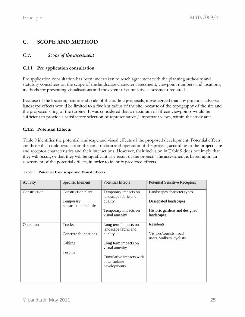
C.1.2. Potential Effects Table 9 identifies the potential landscape and visual effects of the proposed development. Potential effects are those that could result from the construction and operation of the project, according to the project, site and receptor characteristics and their interactions. However, their inclusion in Table 9 does not imply that they will occur, or that they will be significant as a result of the project. The assessment is based upon an assessment of the potential effects, in order to identify predicted effects. Table 9 : Potential Landscape and Visual Effects Activity Specific Element Potential Effects Potential Sensitive Receptors
Construction Construction plant, Temporary construction facilities
Temporary impacts on landscape fabric and quality Temporary impacts on visual amenity
Operation Tracks Concrete foundations Cabling Turbine
Long term impacts on landscape fabric and quality Long term impacts on visual amenity Cumulative impacts with other turbine developments
Landscapes character types Designated landscapes Historic gardens and designed landscapes, Residents, Visitors/tourists, road users, walkers, cyclists
© LandLab, May 2011 25
Ernespie M319/009/11
Decommissioning Construction plant Temporary impacts on landscape fabric and quality Temporary impacts on visual amenity
Modern installation methods used for small scale turbines up to 40m to tip height are quick and efficient, and therefore impacts to the landscape fabric are considered to be temporary and minor in all cases and are not assessed, unless the proposed development site has been identified as ecologically or historically sensitive at pre application consultation. The wind turbines will require a connection to a mains supply. For the purposes of the baseline study it is assumed that the electrical power supply will be provided by a connection to mains supply either directly or by extension from the complex of buildings at Ernespie, and that a substation or similar infrastructure will not be required. If the electrical power supply is installed underground, then the potential adverse landscape and visual effects of this equipment are considered to be minor and are not included in the scope of the assessment. It is considered that significant changes to the topography of the site will not be necessary or desirable, and that the positioning and finished AOD levels of wind turbines will follow the existing topography. It is assumed that a temporary site construction compound, temporary or permanent access tracks are not required. It is assumed boundary features will remain unchanged. Changes to vegetation are considered to be temporary and minor. It is assumed that the development is self contained within the turbine concrete foundation and mast and that no other ancillary development comprising external structures is required. These issues are not assessed.
C.2. Method of Assessment The LVA has been based on guidelines provided in the following publications:
• Landscape Character Assessment: Guidance for England and Scotland (The Countryside Agency and SNH, 2002)
• Guidelines for Landscape and Visual Impact Assessment (Landscape Institute and Institute of Environmental Assessment 1995 and 2nd edition 2002)
The assessment has also drawn on guidance provided from scoping consultations. The existing landscape and visual resource of the study area in terms of its character, quality and sensitivity were evaluated within a study area of radius agreed at pre application consultation, centred on the project site. Where appropriate a description of the detailed methodology adopted for specific tasks is provided under separate subject headings below.
© LandLab, May 2011 26

Ernespie M319/009/11
The aim of LVA is to identify, predict and evaluate potential key effects arising from a proposed development. Wherever possible identified effects are quantified. However, the nature of landscape and visual assessment requires interpretation by professional judgement. In order to provide a level of consistency to the assessment, the prediction of magnitude and assessment of significance of the residual landscape and visual effects have been based on predefined criteria (see Table 10 -Table 13).
C.2.1. Sensitivity The sensitivity of the landscape is not absolute and varies according to the existing landscape, the nature of the proposed development and the type of change being considered. The determination of the sensitivity of the landscape resource to changes associated with the proposed development is defined as high, medium, low or neutral and is based on professional interpretation of a combination of parameters, as follows
• landscape quality, as reflected by local, regional or national landscape designation
• landscape scale – which is the relative size of the main landscape elements and components
• the nature of views – whether open, closed, long or short distance, simple or diverse and
• key landscape characteristics – which is a professional evaluation based on the key characteristics of the landscape
Table 10 : Influence of parameters on the sensitivity of the landscape Landscape Quality Landscape Scale Nature of Views Sensitivity
High Small Panoramic, long distance High
Medium Medium Open, medium distance Medium
Low Large Closed, short distance Low
The weighting of visual receptor sensitivity is based on an interpretation of a combination of parameters as follows:
• the location of the viewpoint,
• the context of the view,
• the activity of the receptor and
• the frequency and duration of the view.
Visual receptor sensitivity is defined as high, medium, low or neutral as follows:
© LandLab, May 2011 27
Ernespie M319/009/11
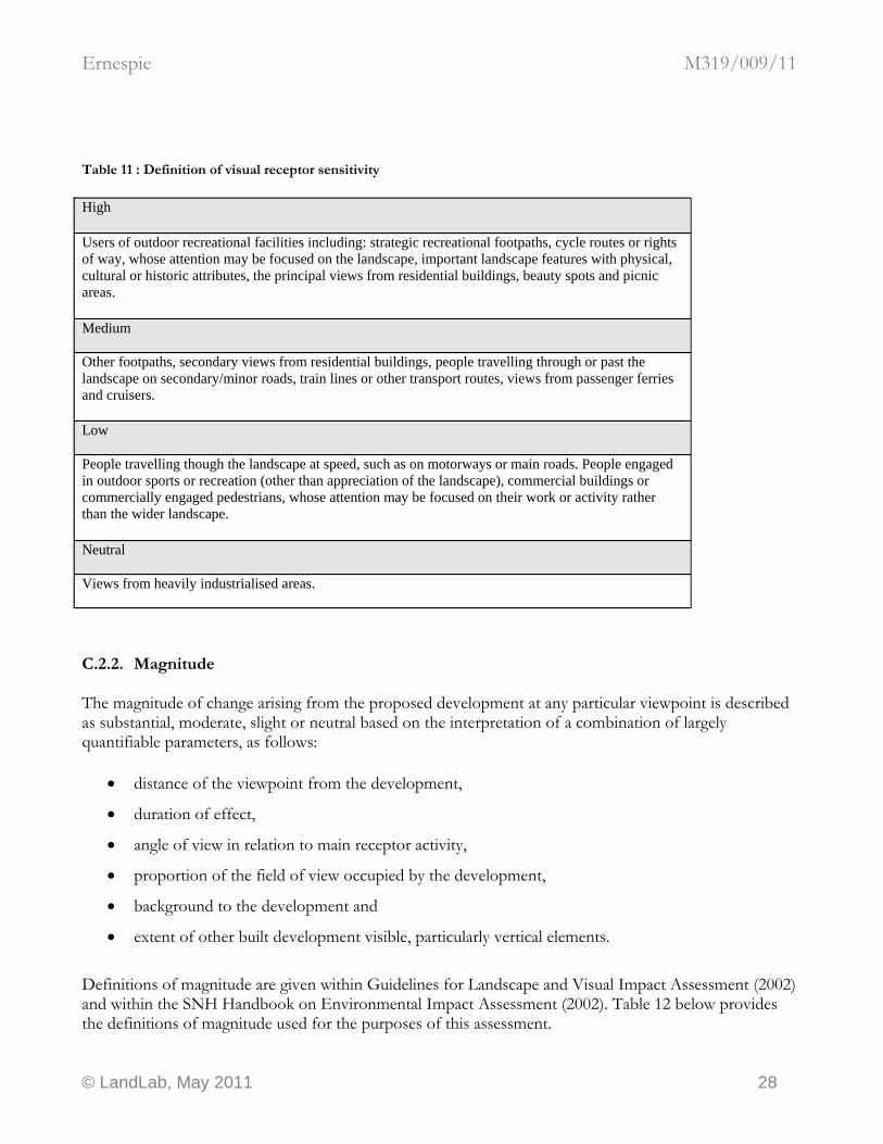
Table 11 : Definition of visual receptor sensitivity High
Users of outdoor recreational facilities including: strategic recreational footpaths, cycle routes or rights of way, whose attention may be focused on the landscape, important landscape features with physical, cultural or historic attributes, the principal views from residential buildings, beauty spots and picnic areas.
Medium
Other footpaths, secondary views from residential buildings, people travelling through or past the landscape on secondary/minor roads, train lines or other transport routes, views from passenger ferries and cruisers.
Low
People travelling though the landscape at speed, such as on motorways or main roads. People engaged in outdoor sports or recreation (other than appreciation of the landscape), commercial buildings or commercially engaged pedestrians, whose attention may be focused on their work or activity rather than the wider landscape. Neutral
Views from heavily industrialised areas.
C.2.2. Magnitude The magnitude of change arising from the proposed development at any particular viewpoint is described as substantial, moderate, slight or neutral based on the interpretation of a combination of largely quantifiable parameters, as follows:
• distance of the viewpoint from the development,
• duration of effect,
• angle of view in relation to main receptor activity,
• proportion of the field of view occupied by the development,
• background to the development and
• extent of other built development visible, particularly vertical elements.
Definitions of magnitude are given within Guidelines for Landscape and Visual Impact Assessment (2002) and within the SNH Handbook on Environmental Impact Assessment (2002). Table 12 below provides the definitions of magnitude used for the purposes of this assessment.
© LandLab, May 2011 28
Ernespie M319/009/11
Table 12 : Magnitude Level of Magnitude
Definition of Magnitude
Substantial Total loss or major alteration to key elements/features/characteristics of the baseline (pre-development) conditions such that post development character/composition of baseline will be fundamentally changed
Moderate Partial loss or alteration to one or more key elements/features/characteristics of the baseline (pre-development) conditions such that post development character/ composition/ attributes of baseline will be partially changed
Slight Minor loss of or alteration to one or more key elements/features/characteristics of the baseline (pre-development) conditions. Change arising from the loss/alteration will be discernible but underlying character/composition of the baseline condition will be similar to pre development circumstances/patterns
Neutral Very minor loss or alteration to one or more key elements/features/characteristics of the baseline (pre-development) conditions. Change barely distinguishable, approximating to the “no change” situation.
C.2.3. Significance The significance of any identified landscape or visual effect has been assessed as major, moderate, minor or no effect. These categories have been determined by consideration of viewpoint or landscape sensitivity and predicted magnitude of change as described above, with the following matrix used as a guide to correlating sensitivity and magnitude to determine significance of effects. Table 13 : Correlation of Sensitivity and Magnitude of Effect to Determine the Significance of Effects Magnitude of Change
Landscape and Visual Sensitivity
Substantial Moderate Slight Neutral
High Major Major/ moderate Moderate Moderate/ minor
Medium Major/ Moderate Moderate/ Minor moderate minor
Low Moderate Moderate/ Minor Minor/none minor
Neutral Moderate/ minor Minor Minor/none None
© LandLab, May 2011 29
Ernespie M319/009/11
Where the landscape or visual effect has been classified as major or major/moderate, this is considered to be a significant effect referred to in Schedule 3 of the Environmental Impact Assessment (Scotland) Regulations 1999. It should be noted that significant effects need not be unacceptable or necessarily negative and may be reversible. The matrix is not used as a prescriptive tool, and the methodology and analysis of potential effects at any particular location makes allowance for the exercise of professional judgement.
C.3. Baseline Evaluation The baseline evaluation process comprises three stages: desk study, field survey and analysis. The baseline studies provide a general description of the variety of landscape and visual resources within the application site and study area. This information is evaluated to provide a description, classification and sensitivity evaluation of the landscape of the study area, from which to assess the potential effects from the proposed development. The visual information is evaluated to provide an appropriate list of viewpoints (agreed with the planning authority and statutory consultees if required) for the assessment and includes details of viewpoint grid reference, distance from the proposed development, receptors and rationale for selection. The purpose of the baseline evaluation is to provide a robust description of the landscape and visual resource from which to assess the landscape and visual effects of the proposed development.
C.3.1. Desk study The planning context of this assessment is provided in other supporting information provided with the planning application. In addition, maps and written data about the development site and its environs were reviewed, including:
• Dumfries and Galloway Landscape Assessment – Scottish Natural Heritage Review No. 94 (Land Use Consultants, 1998);
• 1 : 25000 Ordnance Survey maps (Explorer Series)
The baseline landscape and visual resource was evaluated within a five km radius of the proposed development site and the main users of the area, key viewpoints and key features were identified. The potential visual receptors were also identified and classified according to their associated land use (settlements, footpaths, roads etc). The aim of the baseline visual assessment was to ensure that a representative range of viewpoints was included in the visual assessment. The potential extent of visibility of the proposed development was identified by reference to a Zone of Theoretical Visibility (ZTV) map and the potential visual receptors were identified. Having identified these receptors in the study area in relation to the ZTV, it is possible to identify those likely to be affected by the proposed development. An initial selection of viewpoints was chosen to ensure that the viewpoint assessment includes a representative range in relation to the following criteria:
• type of receptor, based on above and including different landscape character types
© LandLab, May 2011 30

Ernespie M319/009/11
• altitude
• distance of receptor from proposed development
• direction of receptor from proposed development, with the aim of achieving a distribution from different compass points around the site.
C.3.2. Field survey Field survey work was undertaken to verify and refine the landscape character types identified within the study area and gain a full appreciation of the relationship between the proposed development and the landscape. In order to make a proper assessment of the potential landscape impacts from selected viewpoints, care was taken to select days when weather was clear and visibility was good. The description and extent of landscape character types identified in the DGLA were compared to field observations, and any differences at the detailed level were noted. Field survey work also verified the appropriateness of the proposed viewpoints. For this study, fieldwork is not supported by wire frames and photomontages, although all observations are recorded with photographs.
C.4. Landscape Character There is considerable diversity of landscape character within this area resulting from the interaction of natural and human influences. These variations in landscape character are described below. The assessment of landscape character types has concentrated on the study area. The study area is covered by the Dumfries and Galloway Landscape Assessment – Scottish Natural Heritage Review No. 94, (Land Use Consultants, 1998). A field survey using standard landscape character assessment field survey forms was carried out to verify and amend as necessary the character types identified by the Dumfries and Galloway Landscape Assessment (DGLA) within the study area. Some refinement of the DGLA may be necessary to reflect the findings of the field survey. The assessment of sensitivity, quality, nature of views, scale, and magnitude follows the guidance set out in the DGLA set out for each Regional Character Area, Landscape Character Type and Landscape Unit. It is noted that although the DGLA provides detailed guidance on the effects of commercial scale wind farms on the landscape, it does not provide specific guidance on individual wind turbines and small groups of turbines connected to farms using the Feed-in-Tariff (FIT) system. It is also noted that the advice in the DGLA is now over a decade old. Further guidance on wind farms is provided in the Dumfries and Galloway Structure Plan Technical Paper No. 5, but this guidance specifically excludes the consideration of small scale developments and developments of less than three turbines.
C.5. SNH Natural Heritage Sensitivity Guidance
© LandLab, May 2011 31
Ernespie M319/009/11
SNH provides a Scotland wide map showing areas of natural heritage sensitivity to windfarms. This map combines the landscape, recreation, biodiversity and earth science sensitivities to provide an overview of natural heritage sensitivity to wind farms. It identifies land with the greatest opportunity for wind farm development in natural heritage terms, and areas where natural heritage sensitivities indicate a medium or high level of constraint. These areas are organised into three zones of increasing sensitivity, as follows. Zone 1: Lowest natural heritage sensitivity identifies areas at the broad scale with least sensitivity to wind farms, with the greatest opportunity for development, within which overall a large number of developments could be acceptable in natural heritage terms, so long as they are undertaken sensitively and with due regard to cumulative impact. Zone 2: Medium natural heritage sensitivity identifies areas with some sensitivities to wind farms. However, by careful choice of location within these areas there is often scope to accommodate development of an appropriate scale, siting and design (again having regard to cumulative effects) in a way which is acceptable in natural heritage terms. Zone 3: High natural heritage sensitivity identifies areas of greatest sensitivity to wind farms, which place the greatest constraint on their development, and where, in general, proposals are unlikely to be acceptable in natural heritage terms. There may, however, be some sites in this zone where wind farm development of appropriate scale and careful design could be accommodated if potential impacts on the natural heritage are fully explored and guarded against by employing the highest standard in siting and design. This zoning system is used by SNH to provide strategic locational guidance on windfarms for local planning authorites in accordance with their policy document Strategic Locational Guidance For Onshore Wind Farms In Respect Of The Natural Heritage, SNH Policy Statement No. 02/02, update March 2009.
C.6. Designations The potential effects of all statutory and non statutory planning designations within the agreed study area and any that are identified at pre application consultation are assessed. A detailed cultural heritage impact assessment of the study area is not in the scope of this LVA and has not been carried out by others. However, aspects of the cultural and natural heritage resources of the study area relevant to the landscape and visual assessment are included. Category B and C(s) Listed Buildings and Non-Inventory Designed Landscapes are not assessed unless requested at pre application consultation. A detailed ecological assessment of the study area is not in the scope of this LVA and has not been carried out by others. The potential effects on habitats (landscape fabric) are not assessed. However, aspects of the ecological resources of the study area relevant to the landscape and visual assessment are included.
C.7. Potential Cumulative Effects Potential cumulative landscape and visual effects arise from the combined effects of development of a similar type. Combined effects relate to the following:
© LandLab, May 2011 32
Ernespie M319/009/11
• extending visibility of wind turbines over parts of the study area from where there are currently
existing wind turbines visible. This gives rise to extended simultaneous visibility of wind turbines at particular locations in the landscape;
• extending visibility of wind turbines over parts of the study area from where there are currently no wind turbines visible, which may give rise to an extended sequential visibility of wind turbines across the landscape;
• both simultaneous and sequential visibility of wind turbines.
In relation to the simultaneous visibility, cumulative effects occur where more than one development is visible in the same direction from a particular place, as well as where wind turbines become visible in more than one direction from that place. In relation to the sequential visibility, cumulative effects occur where the observer has to move to another viewpoint to see other developments, so they appear in sequence, depending on speed of travel and distance between the viewpoints. Dumfries and Galloway is recognised as being well placed for the location of wind turbines. Following pre application consultation, other existing or proposed wind turbine developments may be considered to have a potentially significant cumulative effect on the landscape character: Where these are identified the cumulative effects will be assessed in relation to simultaneous and sequential visibility taking into consideration the relative scale of the different proposals and their location.
C.8. Route corridors and journeys through the landscape There are a range of visual receptors within the study area, including residents at main settlements, villages, building groups and farms, road users travelling on the network of roads, and local people and tourist visitors travelling on the network of footpaths and the publicly accessible land around the application site. In many cases a new development is most often observed as the viewer travels through the landscape. The LVA considers the potential effects of the project as a series of ‘journeys’ through the landscape, expressed through a detailed assessment of residual effects on route corridors.
C.9. Viewpoint Assessment This section comprises the assessment of the residual visual effects arising from the project during the operational period. The potential visual effects arising from the project have been assessed by analysis of the ZTV to provide a general overview of the visibility of the project, detailed analysis of specific visual receptors such as settlements and route corridors and consideration of the potential visual effects at nineteen viewpoints in the study area. A viewpoint analysis has been carried out to identify and evaluate the potential effects on landscape and visual amenity arising from the proposed development at specific representative locations in the study area. The selection of viewpoints has been chosen in consultation with SNH. These viewpoints are considered
© LandLab, May 2011 33
Ernespie M319/009/11
to be representative of the spectrum of receptors in the study area, located at different distances, directions and heights relative to the project. To provide the most accurate approximation of the view from the ‘naked eye’, all photographs are taken with a Canon EOS 500D digital SLR camera, focal length equivalent to a 50mm focal length of a 35mm SLR. Wireframe modelling, photomontages or design visualisations from viewpoints may be provided where potential significant effects are noted, and from other viewpoints upon request of the planning authority at pre application consultation.
C.10. Significant Adverse Effects This section concentrates on the effects arising from the project on the landscape resource and perception of the landscape types, designated areas, and visual receptors within the study area, where the landscape or visual effect has been classified as major or major/moderate. This is considered to be a significant effect referred to in Schedule 3 of the Environmental Impact Assessment (Scotland) Regulations 1999.
C.11. Design Mitigation This section summarises the main aspects of the project which may cause effects upon the landscape and visual amenity of the area and describes the recommended mitigation measures which have been developed through iterative design in order to prevent, reduce or offset potentially adverse landscape and visual effects. There are considerable constraints on turbine selection and siting. The available mitigation options are therefore limited to micro siting and colour finish.
C.11.1. Micro siting The architectural form of the proposed turbine, including height, position and orientation of blades, especially the potential adverse effect of reflected sunlight from blades, are all potential issues of concern. Where feasible micro-siting of the turbines may be possible. Micrositing is the adjustment of the position of turbines within a pre-defined area where it is known that turbine performance will not be significantly compromised. For developments of more than one turbine, the composition of turbines (the position and orientation of the turbines relative to each other) is an important consideration.
C.11.2. Colour finishes The surface treatment to the proposed wind turbines is of a uniform colour. On sensitive sites where it would be appropriate and beneficial to do so, a colour palette appropriate to, and derived from, colours in the surrounding landscape should be devised, comprising between five and nine colours. The colour palette should be designed by a suitably qualified consultant and applied to the wind turbines such that the uniform visual effect of the wind turbines is disrupted. It is noted however that in areas where extreme weather is common place painted finishes do not wear well and that unpainted finishes might be more appropriate, such as a plain galvanised finish on steelwork.
© LandLab, May 2011 34
Ernespie M319/009/11
C.12. Assessment of Residual Landscape and Visual Effects This section concentrates on the effects arising from the project on the landscape resource and perception of the landscape types, designated areas, and visual receptors within the study area, where the landscape or visual effect has been classified as major or major/moderate. This is considered to be a significant effect referred to in Schedule 3 of the Environmental Impact Assessment (Scotland) Regulations 1999.
© LandLab, May 2011 35