Embed Size (px)
Citation preview

Abstract
Electrical resistivity survey was carried out around Abeokuta area of Ogun State, Nigeria, to study the subsurface geologic layer with a view to investigating the failure in Alabata road that stretches about 1000 m. Vertical electrical sounding (VES) data were acquired with ABEM Terameter using Schlumberger electrode configuration at five (5) stations along the profile. The field data obtained was analysed using computer software (IPI2WIN) which gives an automatic interpretation of the observed apparent resistivity. The major lithologic units delineated beneath the study area are topsoil, sandy/sandy clay, and weathered basement layer. The resistivity of the topsoil layer varies from 120.7 to 392.4 ?m with thickness ranging from 1.1 -3.1 m. The sandy/sandy clay has resistivity values ranging from 22.3 - 206.0 ?m and thickness between 3.7 -20.6 m. The weathered basement has resistivity values ranging from 50.7 -1163.9 ?m with infinite depth. However, the depth from the earth's surface to the bedrock surface varies between 1.1-21.7 m. Results of the study have shown that the cause of road failure may be attributed to the sandy/sandy clay nature of the first layer. Keywords: Electrical resistivity, Vertical Electrical Sounding, Lithologic units, Road failure, Apparent resistivity
Investigation of Road Failure at Ogun-Osun-Alabata Road, Nigeria, Using Vertical Electrical Sounding Technique
Layade, G. O., *Ogunkoya, C. O., Ogundele, O. R.
Department of Physics, Federal University of Agriculture, Abeokuta*[email protected]
ATBU Journal of Environmental Technology 11, 1, June, 2018 69
Introduction
The statistics of failures of structures such as
roads, buildings, dams and bridges
throughout the nation has increased
geometrically (Akintorinwa and Adeusi,
2009). Therefore the usefulness of
geophysical investigation in engineering
sector of our economy cannot be
overemphasized. In recent years, many
engineering applications (civil and
geotechnical) involved geophysical
investigation as it provided information in
the design process of structure and utilities;
as well as dams, bridges, highways and
communication masts (Falowo and
Akintorinwa 2015).
Road network is considered very vital in the
economy of any country especially in
developing states. Meanwhile, Nigerian
roads contain lot of pot holes, faults and
sometimes discontinuities. Major highways
in Nigeria are known to fail shortly after
construction and well before their design
age because of absence of thorough
subsurface investigations.
Geo-scientists are utilizing the advancement
of geo-physical tools investigating the earth,
which assist in oil, groundwater and mineral
exploration. There are numerous methods
available in field of geophysics and such
include; electrical resistivity method,
seismic method, gravity method, magnetic
method and electromagnetic method,
among which electrical method is
commonly used for g roundwater
exploration. Resistivity method is one of the
widely used methods to understand the
formation characterization. The method
involves the use of direct current, or
alternating current with frequencies less
than ten cycles per second (Battacharya and
Patra 1969).
Road pavement failure can be defined as a
discontinuity in a road network resulting
from cracks, potholes, bulges and
depression. A road network is supposed to be
a continuous stretch of asphalt layer for a
smooth ride. Visible cracks, potholes and
depressions generally regarded as road
failure may punctuate such smooth ride
(Rahaman 1976, Aigbedion 2007). Flexible
highway (i.e. good and well developed
interconnectivity of roads) aids easy and
smooth vehicular movement, and have been
very useful for transportation of people,
goods and services from one point to
another, especially in developing countries
where other means of transportation such as
rail, underground tube, air, and water
transportation systems have remained
largely undeveloped. However, bad portions
70 ATBU Journal of Environmental Technology 11,1, June, 2018
Investigation of Road Failure at Ogun-Osun-Alabata Road, Nigeria, UsingVertical Electrical Sounding Technique
of road, many of which result from poor
construction or incompetent sub-grade and
sub-base materials had been found to do
more harm than good. They have been
responsible for many fatal accidents,
wearing down of vehicles and waste of
valuable time during traffic jams (Osinowo,
2011).
Geophysical survey incorporates the
Vertical Electrical Sounding (VES) and
Horizontal Profiling (HP) probes. The
Vertical Electrical Sounding (VES) is
currently very popular with groundwater
investigations due to the ease in data
acquisition and interpretations. This
geophysical survey method is the detection
of the surface effects produced by the flow
of electric current inside the earth. It
provides depth and thickness of various
subsurface layers and their relative water
yielding capacities (Okwueze and
Ezeanyim, 1985).
In vertical electrical sounding (VES) the
goal is to observe the variation of resistivity
with depth. The technique is best adapted to
determining depth and resistivity for flat-
lying layered rock structures, such as
sedimentary beds, or the depth to the water
table (Ikechukwu, 2014). The Schlumberger
configuration is most commonly used for
potential pairs of electrodes have a common
mid-point, but the distances between
adjacent electrodes differ. The mid-point of
the array is kept fixed while the distance
between the current electrodes is
progressively increased. This causes the
current lines to penetrate over greater
depths, depending on the vertical
distribution of conductivity (Lowrie, 1997).
The Schlumberger electrode array is
commonly adopted in the Vertical Electrical
Sounding (VES) technique due to its field
logistic advantage of having to move only
two electrodes at a time. This reduces the
man power requirement thereby minimizing
survey cost. Where large depth of
investigation is required, large electrode
spacing is adopted. This is also the case
when the substratum is very conductive due
to high clay content or saline water intrusion
and current flow lines converge, leading to
shallow depth of investigation (Telford et
al., 1990).
The study applied vertical electrical
sounding to investigate the cause of the road
failure along Alabata road. Momoh et al.,
2008 used VES among other methods to
examine the geological factors responsible
for highway failure in basement complex
terrain of southwestern Nigeria. The result
ATBU Journal of Environmental Technology 11, 1, June, 2018 71
Layade / Ogunkoya / Ogundele

identified suspected geological features and
the clayey sub-grade soil below the highway
pavement as the major geologic factors
responsible for the highway failure
Ifabiyi and Kekere (2013) examine some of
the factors responsible for road failure along
Ilorin-Ajase Ipo road, Kwara State Nigeria.
The results showed that poor foundation
m a t e r i a l s a n d p o o r E n g i n e e r i n g
Construction have affected the rate of failure
of the road along Ilorin-Ajase Ipo road.
Osuolale et al., 2012 investigated that the
pressure causes of the highway failure along
Ibadan-Iseyin road, Oyo-State Nigeria. The
results revealed that some samples of
subgrade and sabbage materials do not
conform to Federal Ministry of Works
specifications for road work and this may be
responsible for the road failure.
In their work, Layade et al., (2017)
investigated the causes of road pavement
failure along Ibadan-Lagos dual carriage
road. The results revealed that, the topsoil
and weathered layer are composed of clay
and sandy clay formation and the fractured
bedrock is linked to the lithology contacts
whose high porosity and permeability
allows the flow of water to the surface which
can be absorbed by the clay at the topsoil.
However, the road structural failure may
also be caused by the use of substandard
construction materials and unethical
construction practices.
The Study Area
The road investigated in this study is a
portion of Alabata road, Abeokuta. The
study area of about 1000 m lies between 0 0 longitude 3 26' 22.61'' and 3 26' 13.81''E
0 0 and latitude from 7 11' 54.75'' to 7 11'
26.01''N. Alabata road is a road that links the
Federal University of Agriculture, Abeokuta
(FUNAAB) with the outside world (Figures
1). The economic, educational and political
sections of the university depend solely on
this road. Some years ago, the road was
constructed to allow easy movement to and
fro the campus.
Also, the lack of drainage system along the
study area has resulted in the flooding and
washing away of the pavement. Over the
years, the road experienced lots of failure
(pot holes, faults, cracks, etc.) which
affected the academic and economic growth
of the institution to date.
72 ATBU Journal of Environmental Technology 11,1, June, 2018
Investigation of Road Failure at Ogun-Osun-Alabata Road, Nigeria, UsingVertical Electrical Sounding Technique

Methodology
Vertical Electrical Sounding (VES) using
Schlumberger array was carried out in the
study area. The principal instrument used to
obtain VES data from the field is ABEM
(Signal Averaging System. (SAS 300)
Terrameter. The Terrameter in the resistivity
surveying mode operates with battery
power, a resistivity meter (with an output
display sufficient for current electrode
separation of 1000 m).
The distance covered by the survey was
about 1000 m and a total of five (5) VES data
set were obtained across the failed segments
of the roadway. The resistance readings at
every point were automatically displayed on
the digital readout and recorded. The
geometric factor, G, was first calculated for
all the data stations. The values obtained
were then multiplied with the resistance
values to obtain the apparent resistivity,
Figure 1: Failed portion along Alabata road
ATBU Journal of Environmental Technology 11, 1, June, 2018 73
Layade / Ogunkoya / Ogundele

The advantages of the Schlumberger array
are fewer electrodes need to be moved to
each sounding and the cable length for the
potential electrode is shorter. Schlumberger
sounding generally have better resolution,
greater probing depth, and less time-
consuming field deployment than the
wenner array. The disadvantages are that
long current electrode cable is required, the
recording instrument needs to be very
sensitive, and the array may be difficult or
confusing to coordinate in the field (Keller,
1966).
Discussion of Results
Vertical Electrical Sounding Profiling 0 VES 1 is located at latitude 7 11 '54.75" and
0 longitude 3 26' 22.61". The curve type of VES
1 is H with three geo-electric layer. The first
geo-electric layer of this figure is comprised
of topsoil with resistivity values 0f 148.8 ?m
and the thickness is 3.1 m and the depth of
3.1 m as shown in Table 1. The second geo-
electric layer composed of sandy clay with
resistivity values of 22.3 ?m and thickness is
20.6 m. The third geo-electric
Figure 2: Study area showing the VES points
74 ATBU Journal of Environmental Technology 11,1, June, 2018
Investigation of Road Failure at Ogun-Osun-Alabata Road, Nigeria, UsingVertical Electrical Sounding Technique
layer is composed of fractured basement
with resistivity value of 718.5 ?m (Figures 3
and 8a).
0 The curve type of VES 2 located at latitude 70 11' 47.42" and longitude 3 26' 20.55 is KH with
four geo-electric layers. The first geo-
electric layer is composed of topsoil with,
resistivity values of 275.7 ?m and thickness
of 2.1 m and of depth 2.1 m respectively
(Table 1). The second geo-electric layer is
composed sandy clay with resistivity values
of 109.2 ?m and thickness 10.3 m and depth
of 12.4 m. The third geo-electric layer is
composed of saturated sandy clay with
resistivity of 19.3 ?m and thickness of 30.9
m. The fourth geo-electric layer is composed
of the weathered fractured basement layer
with resistivity value 341.2 ?m. (figures 4
and 8b)
0 In the VES 3 located at latitude 7 11' 40.22" 0 and longitude 3 26' 17.91", the curve type of
VES 3 is H with three geo-electric layer
VES 4 has 3 geo-electric layer. The first geo-
electric layer of this V.E.S is composed of
topsoil with resistivity values 0f 392.4 ?m
and the thickness is 1.7 m and the depth of
1.7 m. The second geo-electric layer
composed of sandy clay with resistivity
values of 206.0 ?m and thickness is 18.8 m
(Table 1). The third geo-electric layer is
composed of fractured basement with
resistivity value of 71163 ?m as shown in
Figures 5 and 8c respectively.
0 VES 4 is located at latitude 7 11' 32.44" and 0 longitude 3 26' 16.61". The curve type of VES
4 is KH with four geo-electric layers. The
first geo-electric layer of this VES is
composed of topsoil with, resistivity values
of 120.7 ?m and thickness of 1.1 m and of
depth 1.1 m. (Table 1). The second geo-
electric layer is composed of sandy clay with
resistivity values of 94.4 ?m and thickness
3.7 m and depth of 4.8 m. The third geo-
electric layer is composed of saturated sandy
clay with resistivity of 14.2 ?m and
thickness of 17.1 m. Figures 6 and 8d show
the fourth geo-electric layer composed of
the fractured basement layer with resistivity
value 597.8 ?m.
0 The location of VES 5 is found at latitude 70 11' 26.01" and longitude 3 26' 13.81". The
curve type of VES point is QH geo-electric
layers. The first geo-electric layer of this
VES is composed of topsoil with, resistivity
values of 356.8 ?m and thickness of 2.1 m
and of depth 2.1 m. The second geo-electric
layer is composed clayey soil with
resistivity values of 142.0 ?m and thickness
7.4 m and depth of 9.5 m. The third geo-
electric layer is composed of lateritic soil
ATBU Journal of Environmental Technology 11, 1, June, 2018 75
Layade / Ogunkoya / Ogundele

with resistivity of 632.2 ?m and thickness of
17.1 m. The fourth geo-electric layer is
composed of the fractured basement layer
with resistivity value 50.7 ?m in figures 7
and 8e.
Table 1: The results of VES stations (1-5) of the study area
VES station
Resistivity (?m)
Thickness (m)
Depth (m)
Number of layers/Curve
Lithology
1 148.8
22.3
718.5
3.1
20.6
3.1
23.7
3
H
Top soil
Sandy
Basement rock2 275.7
109.2
19.3
341.2
2.1
10.3
18.5
2.1
12.4
30.9
4
KH
Top soil
Sandy claySaturated sandy clay
Weathered basement
3 392.4 206.0
1163.9
1.7 18.8
1.7 20.5
3 H
Top soil Sandy clayBasement rock
4 120.7
94.4
14.2
597.8
1.1
3.7
12.3
1.1
4.8
17.1
4
KH
Top soil
Sandy claySaturated sandy clay
Weathered layer5 356.8
142.0632.250.7
2.1
7.412.3
2.1
9.521.7
4
QHTop soil
Sandy claylateriteWeathered basement
Figure 3: Interpreted Schlumberger depth sounding curve for VES 1.
76 ATBU Journal of Environmental Technology 11,1, June, 2018
Investigation of Road Failure at Ogun-Osun-Alabata Road, Nigeria, UsingVertical Electrical Sounding Technique

Figure 4: Interpreted Schlumberger depth sounding curve for VES 2.
Figure 5: Interpreted Schlumberger depth sounding curve for VES 3
ATBU Journal of Environmental Technology 11, 1, June, 2018 77
Layade / Ogunkoya / Ogundele
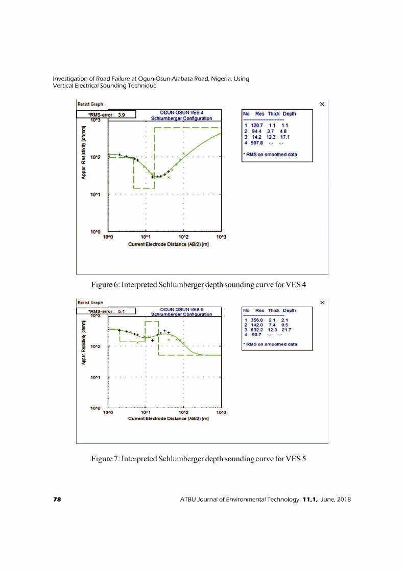
Figure 6: Interpreted Schlumberger depth sounding curve for VES 4
Figure 7: Interpreted Schlumberger depth sounding curve for VES 5
78 ATBU Journal of Environmental Technology 11,1, June, 2018
Investigation of Road Failure at Ogun-Osun-Alabata Road, Nigeria, UsingVertical Electrical Sounding Technique

Geoelectric Section
Geoelectric section for the study area was
drawn along VES 1-VES 5 for the road
(Figure 9). The geoelectric section for the
road is characterized by layers of topsoil,
sandy clay (clayey), saturated sandy clay and
fractured basement layer except for VES 5,
where there is sandy clay (laterite) and
weathered basement. The first layer is
topsoil which has resistivity ranges from
392.4 Ùm with thickness ranging from 1.1-
3.1 m. The second layer resistivity (sandy
clay) ranges from 22.3 -206 Ùm and the
thickness ranging from 3.7-20.6 m. The
fractured basement layer have resistivity
ranging from 50.3 -1163.9 Ùm. The
saturated sandy clay which is found in VES 2
and VES 4 have resistivity ranging from 14.2
-19.3 Ùm and thickness from 12.3-18.5m.
Figure 8: (a) Inferred lithology of VES 1, (b) Inferred lithology of VES 2, (c ) Inferred
lithology of VES 3,(d ) Inferred lithology of VES 4,(e ) Inferred lithology of VES 5.
ATBU Journal of Environmental Technology 11, 1, June, 2018 79
Layade / Ogunkoya / Ogundele
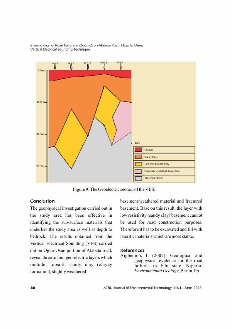
Conclusion
The geophysical investigation carried out in
the study area has been effective in
identifying the sub-surface materials that
underlies the study area as well as depth to
bedrock. The results obtained from the
Vertical Electrical Sounding (VES) carried
out on Ogun-Osun portion of Alabata road;
reveal three to four geo-electric layers which
include: topsoil, sandy clay (clayey
formation), slightly weathered
basement/weathered material and fractured
basement. Base on this result, the layer with
low resistivity (sandy clay) basement cannot
be used for road construction purposes.
Therefore it has to be excavated and fill with
lateritic materials which are more stable.
ReferencesAigbedion, I. (2007). Geological and
geophysical evidence for the road failures in Edo state, Nigeria. Environmental Geology, Berlin, Pp
Figure 9: The Geoelectric section of the VES.
80 ATBU Journal of Environmental Technology 11,1, June, 2018
Investigation of Road Failure at Ogun-Osun-Alabata Road, Nigeria, UsingVertical Electrical Sounding Technique
101- 103.Akintorinwa, O. J. and Adeusi, F. A. (2009).
Integration of Geophysical and Geotechnical investigation for a proposed lecture room Complex at t h e F e d e r a l U n i v e r s i t y o f Technology, Akure, Southwestern, Nigeria. Ozean journal of Applied sciences 2(3): 1943-2429.
Battacharya, P. K. and Patra (1969). Direct current geoelectric sounding, Elsvier, Amsterdam.
Falowo, O. O and Akintorinwa, O. J. 2015. Geophysical Investigations of a Pavement Failure Along Akure-Ijare Road, Southwestern Nigeria. IOSR Journal of Applied Geology and Geophysics (IOSR-JAGG) 3: 45-54
Ifabiyi, I. P. and Kekere, A. A. (2013). Geochemical investigation of road failure along Ilorin-Ajase Ipo road, Kwara State Nigeria. Journal of environmental and earth sciences 3(7): 91-96.
Ikechukwu, B. I. 2014. Investigation of Variation in Resistivity with depth in Parts of Imo River Basin, South-eastern Nigeria. IOSR Journal of Applied Physics. 6(1): 47-54
Layade, G. O., Adegoke, J. A., Oyewole, I.T. (2017): Integrated geophysical investigation for
The causes of road pavement failure along Ibadan-Lagos dual -car r iage , Southwestern,
Nigeria. Journal of Applied Science & Env i ronmenta l Management (UNIPORT), Vol.21 (3), 547-554. https://dx.doi.org/10.4314/jasem.v21i3.16
Lowrie, W. 1997. Fundamentals of Geophysics (Cambridge University Press, England).
Momoh, L. O., Akintorinwa, O. and Olorunfemi , M. O. (2008) . Geophysical investigation of Highway failure- A case study from the Basement Complex Terrain of Southwestern Nigeria. Journal of Applied Sciences Research 4(6): 637-648.
Okwueze, E.E, and Ezeanyim, V.I (1985). The Vertical Electrical Sounding (VES). Method in Laterite regions and in iron rich glaciated areas J. mining geol., 22(1-2): 193- 198.
Osinowo, O. O., Akanji, A. O., and Akinmosin A. (2011). Integrated geophysical and geotechnical investigation of the failed portion of a road in basement complex Terrain, Southwest Nigeria. Materials and Geoenvironment, 58 (2): 143–162.
Osuolale, O. M., Oseni, A. A. and Sanni, I. A. (2012). Investigation of highway pavement failure along Ibadan-Iseyin road, Oyo State Nigeria. I n t e r n a t i o n a l J o u r n a l o f E n g i n e e r i n g R e s e a rc h a n d Technology. 1(8), 1-6.
Rahaman, O. J, (1976). Review of Basement Geology of Smith, Western Nigeria.
Telford, W. M., Geldart, L. P. and Sheriff R. E. (1990). Applied Geophysics. (Second Edition). Cambridge University Press: Cambridge, UK.
ATBU Journal of Environmental Technology 11, 1, June, 2018 81
Layade / Ogunkoya / Ogundele