Embed Size (px)
Citation preview

Geological Survey of Denmark and Greenland Ministry of Climate and Energy
Integrated groundwater management in Denmark
Bjørn Kaare Jensen
Deputy Director General
Geological Survey of Denmark and Greenland
TAIEF Expert mission to China on Groundwater Monitoring
WRISD, Jinan, November 19 – 23, 2015

Main challenges
• Groundwater contamination from diffuse pollution and point source pollution
• Groundwater over-abstraction and depletion due to geographically uneven recharge patterns
• Climate change effects

The bottom Line Drinking water in Denmark for all purposes is derived entirely from groundwater and it is consumed after very simple treatment and without addition of chlorine
• Strong incentive to protect the groundwater resources
• Strong incentive to save and reuse groundwater and increase ground-water recharge
• High awareness on groundwater protection in the population
• Basis for keeping high water price
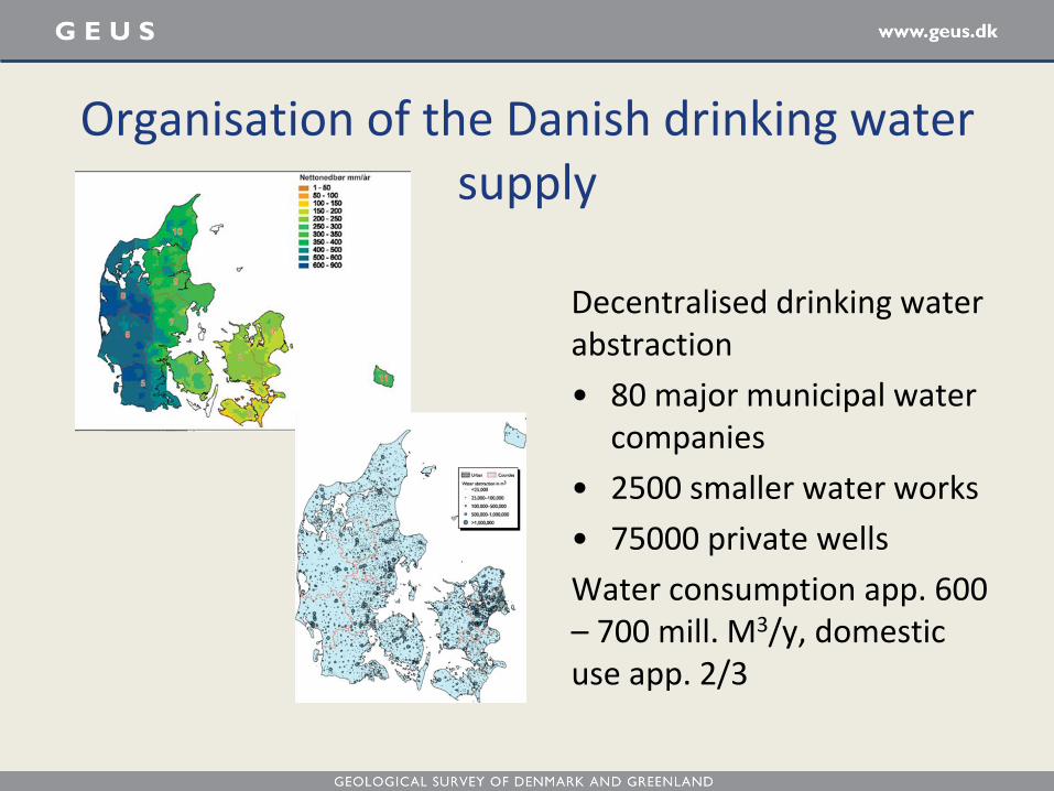
Organisation of the Danish drinking water supply
Decentralised drinking water abstraction
• 80 major municipal water companies
• 2500 smaller water works
• 75000 private wells
Water consumption app. 600 – 700 mill. M3/y, domestic use app. 2/3

From groundwater to drinking water – very simple treatment
Water treatment plant Water tank Customers
Well Aeration Filtration
Flush water
Groundwater
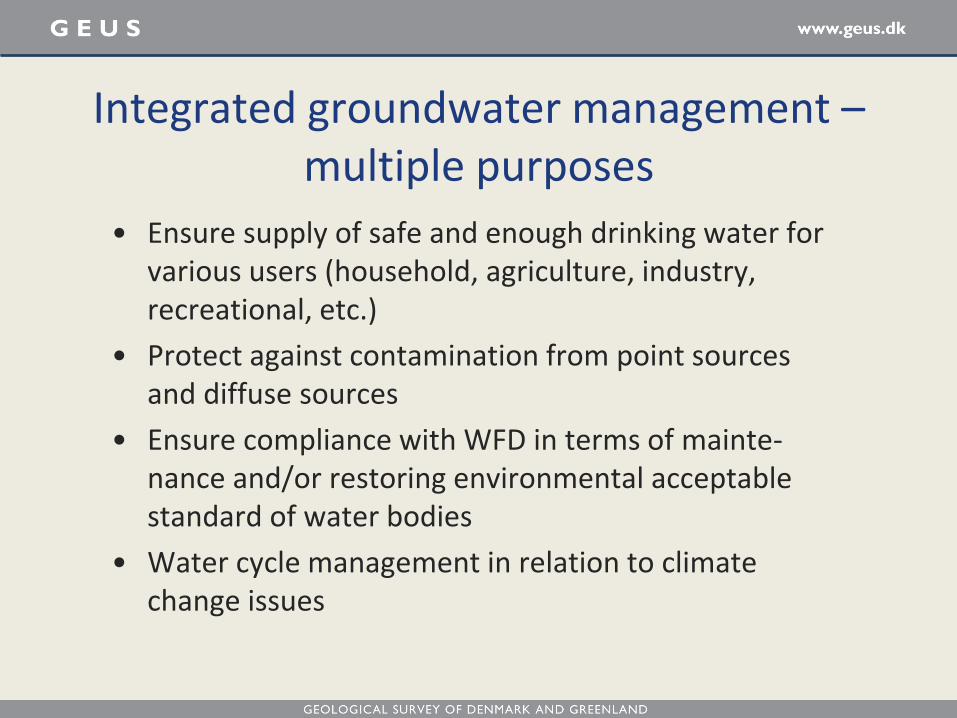
Integrated groundwater management – multiple purposes
• Ensure supply of safe and enough drinking water for various users (household, agriculture, industry, recreational, etc.)
• Protect against contamination from point sources and diffuse sources
• Ensure compliance with WFD in terms of mainte-nance and/or restoring environmental acceptable standard of water bodies
• Water cycle management in relation to climate change issues

1. Strong tradition/long history
2. Strong knowledge/research base
3. National commitment
4. Transparent and non-bureaucratic regulatory system
5. Partnerships across the sector
6. Public (and political) concern and awareness
Groundwater management in Denmark rests on 6 ground pillars

• Ministry of the Environment and Food is responsible for the overall planning, protection, mapping, monitoring and climate adaptation as well as legislation and guidance documents
• 5 regional authorities take care of remediation of contaminated sites
• 98 municipalities are responsible for concrete measures to counteract contamination and climate change effects, water action plans, licensing as well as waste water treatment
• Water supply companies and water works take care of water abstraction and drinking water supply
• The Geological Survey of Denmark and Greenland (GEUS) cooperates with the Nature Agency in the implementation of the monitoring and mapping programmes, is responsible for data storage and maintains databases
Organisation of the Danish groundwater management system
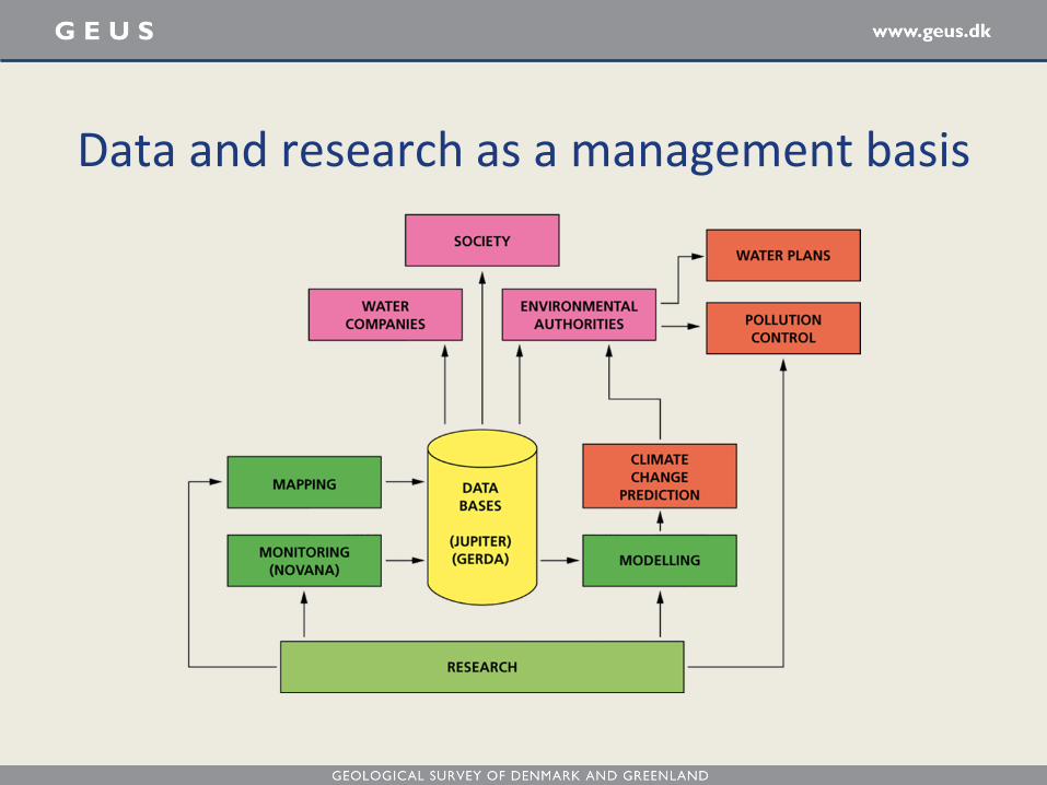
Data and research as a management basis

• NPo research program (1985 - 90)
• Soil and groundwater program (1993 – 95)
• Contaminated site technology development program (1996 - 2015)
• Strategic Environmental Research program (1992 - 2004)
• Pesticide Research Program (1992 – 2015)
• Testing Centre for Water Technology (2012 – 15)
• Foundation for Development of Technology in the Danish Water Sector - VTU (2011 – 15)
• Development of Environmental Technology – MUDP (2010 – 2015)
The strong knowledge/research base - Examples of Danish water RTD programs
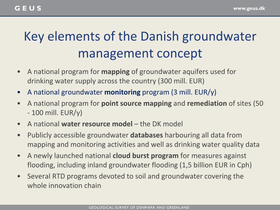
• A national program for mapping of groundwater aquifers used for drinking water supply across the country (300 mill. EUR)
• A national groundwater monitoring program (3 mill. EUR/y)
• A national program for point source mapping and remediation of sites (50 - 100 mill. EUR/y)
• A national water resource model – the DK model
• Publicly accessible groundwater databases harbouring all data from mapping and monitoring activities and well as drinking water quality data
• A newly launched national cloud burst program for measures against flooding, including inland groundwater flooding (1,5 billion EUR in Cph)
• Several RTD programs devoted to soil and groundwater covering the whole innovation chain
Key elements of the Danish groundwater management concept

The 4 M’s as a basis for groundwater management in Denmark
Integrated
Management
Mapping
Measurement Monitoring
Modelling

Detailed information right from ground surface to 2 – 300 m’s depth Sand = groundwater Clay = no groundwater
Groundwater mapping with SkyTEM

• The groundwater monitoring programme as a part of the National Monitoring Programme on the Aquatic Environment and the Nature (NOVANA)
• Monitoring of drinking water production wells
• Monitoring of point source pollution from contaminated sites and landfills
• Monitoring of site remediation performance
Different types of groundwater monitoring

• NOVANA is coordinated by The Ministry of the Environment and Food (MFVM), operated by the Nature Agency in MEV, national budget with research institutes in charge of content and development, guidelines to uniform, certified labs
• First national groundwater table monitoring programme in 1950
• In 1987, a political agreement on a new programme
• 2004: The national groundwater table monitoring programme is integrated in the overall monitoring programme
• Revised every 6th year – substances in and out – shifting focus; next time 2016
• Initial focus of nutrients, then pesticides, now quantity – integrating surface and groundwater
• Annual national reporting
Groundwater monitoring in DK

• Jupiter (3’rd generation database)
– Wells (geology, technical completion, water levels, groundwater chemistry, scanned well reports, …)
– Water works (drinking water chemistry, abstraction)
• Gerda
– Shallow geophysical data (electric, electromagnetic, seismic, borehole logs)
• ModelDB
– 3D geological and hydrogeological models
• ReportDB
– Digital reports about hydrogeology
Groundwater databases

Objectives: • To assess groundwater recharge at large scale /at
groundwater body level • To assess the size of the groundwater resource and
the rate of exploitation taking into account land-use, climate change effects and abstraction strategy
• Assess the size of the exploitable groundwater resource
• Platform for more detailed models • Developed by GEUS
National Water Resource Model DK-model

• More precipitation and cloudbursts leading to Groundwater flooding (adverse effects on agriculture and urban infrastructure)
• Enhanced transport of contaminants in soil and groundwater leading to renewed exposure of contaminants in landfills and contaminated sites
• Enhanced salt water intrusion in coastal areas due to sea level rise
• Enhanced breaking and leakage from sewer systems leading to higher risk of groundwater contamination
• Drought leading to lowering of water table and soil subsidence requiring revised groundwater abstraction strategies
• More infiltration of rainwater in the cities leading to elevated groundwater levels and potential damage to infrastructure
Climate change effects on the water cycle

• Selection of parameters for the compulsory control of the water quality in the abstraction wells for water production
• Input to administration of the use of pesticides
• New parameters or focus addressing upcoming policy needs – as implementing EU legislation
• Focus on bad quality in shallow groundwater – investigation of private dug and drilled wells
• Basis for assessment of possible adverse effects from ground-water surface water interactions
Input from groundwater monitoring to groundwater management and vice versa

Thank you for your attention!