Embed Size (px)
Citation preview

1
Ellesmere Port and Neston Borough Council Planning Services
Ince Conservation Area
Character Appraisal

2

3
Ince Conservation Area Character Appraisal 1 Introduction
1.1 This document aims to provide an assessment of the special
architectural and historic interest of Ince Conservation Area. It forms supplementary planning guidance to the adopted Ellesmere Port and Neston Borough Local Plan and Policy ENV14 in particular. It is designed to help guide decisions on planning applications in the conservation area, and assist applicants in drawing up schemes. It will also be used to formulate proposals for the preservation and enhancement of the conservation area. The Local Plan has been prepared having regard to the County Structure Plan Policy R1, national planning guidance such as that issued by English Heritage and Regional Planning Guidance.
1.2 The appraisal is not intended to be a comprehensive plot by plot survey, and omission of any particular building, feature or space should not be taken to imply that it is of no interest.
1.3 This document will hopefully raise awareness of the special qualities of the conservation area, so that as Ince Conservation Area continues to evolve, it does so in a sympathetic way and the pleasing character of the conservation area is maintained for future generations.
1.4 This appraisal was formally adopted 14th September 2004.
Ince Hall, demolished 1960

4
Ince Conservation Area Appraisal. 2 Physical Setting 2.1 Ince is found on the southern shore of the Mersey Estuary, midway
between Ellesmere Port and Helsby and eight miles to the east of Chester. Ince is a modern derivative of the Welsh for island, a reflection of its raised and isolated position on the marshy banks of the Mersey. The village is located on a tongue of Bunter sandstone. The parish church occupies the highest land in the village, but still less than 100' above sea level.
3 Settlement Development 3.1 The precise origins of Ince are not clear but it was the location of a
monastic grange supporting St Werburgh's Abbey, Chester. The function of the grange was to provide food and raw materials for the parent monastic house.
3.2 In 1804, the estate was purchased by Robert Peel (grandfather of the
reforming Prime Minister) and Edmund Yates Esq.'s, attracted by the possibilities of wild fowl shooting. Edmund Yates became sole possessor within a year.
3.3 Although the modern village appears to be primarily agricultural,
maritime activities were an important source of income for much of its history. For many centuries there was a ferry to Liverpool and Edmund Yates was responsible for the construction of a hotel, for ferry passengers, at what is now 1,2 & 3 The Square. The former hotel is a two storey terrace built in brown brick in Flemish bond with a Welsh slate hipped roof with a simple central pediment. The hotel made up, with contemporary buildings at 7,8 & 9, the formal square at the heart of the village. At its peak there was also a fully licensed public house and a lighthouse on the coast. The opening of the local railway, in 1863, ended the ferry service.
3.4 Fishing was also important and access to the river would later be a
condition of the building of the Manchester Ship Canal. One of Edmund Yates's initiatives was to build New Row (familiarly known as Fish Row) on Marsh Lane (now the site of bungalows), to replace the fishermen's cottages that were pulled down between Hall Farm and Wood Farm, when Ince Hall was constructed.
The Square

5
3.5 On Yates's death, in 1835, his landed property was left in trust to his youngest daughter Elizabeth Jane. She married Rev William Waldegrave Park, curate of Shipbourne, and the couple moved to Ince for health reasons. In 1837 Rev Park became minister at Ince but died in 1842. In 1849, Elizabeth Jane enlarged Ince Hall, an Italianate mansion in white freestone. This house had initially been constructed in the early 19th Century and stood in a park of 69 acres and was approached by a mile long drive, beginning at a lodge on Pool Lane. The lodge has long gone, but the main entrance gates can still be seen, as can the abutments of a bridge, near Yew Tree Farm, that took the carriage drive over a farm track, on its way to the hall. Elizabeth Park also paid for the cost of restoring St James Church, in 1854, rebuilding the nave and heightening the tower.
3.6 Ince Hall, the home of the Park Yates family for 100 years, was used
as accommodation for Shell personnel evacuated during the war. The hall was demolished in 1960.
4 Townscape
General 4.1 Ince, despite its proximity to industry, still retains its rural village
atmosphere. This is helped by the screening of the nearby refinery provided by the trees of the former parkland of Ince Hall. The village also retains its medieval street pattern, which largely determines the informal layout of buildings within the village. In contrast at the centre of the village can be found the formal village square.
4.2 Away from The Square, the buildings are an informal collection of
vernacular buildings of various dates, many being of considerable interest in their own right. The plots are generally bounded by sandstone walls , which enclose many mature trees and hedgerows within.
4.3 The present village has largely grown up to the north and east of the
church, and more recently along the road to nearby Elton. 4.4 Character Zone A: The Square: At the centre of the village is The
Square, built in the early C19th when Edmund Yates sought to exploit Ince as a leisure destination. Although called The Square the space is actually the convergence of two triangles where the roads from Elton and Chester meet. The formal Georgian terraces form two sides of a right angle. Opposite, and at the corner of the Elton and Chester Roads, is a detached house that appears to be contemporary with Edmund Yates's buildings but was altered by the addition of a porch and two bay windows in the 1920's. Yates buildings all display a simplified classicism and are well proportioned but with little decoration, using local brown bricks and hipped roofs of Welsh slate.

6
Ince Manor Great Hall
4.5 Character Zone B: Ince Manor: To the north-west of The Square the land is largely occupied by the remains of the medieval manor and its ancillary buildings. The large Tudor windows of the hall dominate the route into the village from Marsh Lane (the former route to the shore). These buildings are simple muscular buildings built in local materials and are surrounded by the medieval sandstone walls of the Manor. A small amount of modern infill has occurred such as a C20th bungalow and detached house which, although neat, make no contribution to the historic character of the village. The properties in this area are linked by informal tracks which contribute to the rural atmosphere of this part if the village.
4.6 Character Zone C: Farmland to West of Village: The area to the west
of the village and south of Kinseys Lane contains the remains of the historic parkland associated with Ince Hall. To the north of Kinseys
Lane is the former site of the fishponds associated with the manorial grange but now an area of farmland containing the Yew Tree Farm, Hall Farm, Wood Farm and Badgers Cottage. This area also includes the sandstone wall that once bounded Ince Hall and park. The farms in this area contain some of the oldest buildings in Ince, dating from the 16th, 17th, 18, and 19th Centuries, and including the 17th Century cruck framed shippon attached to Wood Farm and two17th Century longhouse farmhouses
4.7 Character Zone D: Marsh Lane :The most important and imposing
building on Marsh Lane is the hall of Ince Manor, its massive Tudor windows overlooking the road and dominating the approach to the village from the Marshes. Its grounds may have extended further suggested by surviving earthworks, banks, ditches and boundary walls. The entrance door to the hall is also defended against attack. Traces of a ditch are still visible to the north of Monastery Cottages and the east
Hall Farm

7
side of the Hall. Part of the ditch lies under Marsh Lane, which indicates that the lane was later than the ditch. Marsh Lane was
improved and extended by Yates in the early C19th to give improved access to a new ferry route to Liverpool. There are other important buildings in Marsh Lane. Opposite the Manor, Smithy Farm has a cruck framed structure, and is likely to be in the region of 500
years old. The building also shows evidence of a former thatch roof. The village pub appears to be Georgian, which tallies with its name The Duke of Wellington although an inspection to the rear shows that the building was built in two parts, possibly a Georgian brick building with a later stone extension. The former village smithy is now renamed Anvil Lodge and is adjacent to the village stocks. The
conservation area boundary is situated to the north of Ince Manor but just outside the conservation area, modern buildings exist on the footprints of earlier buildings, notably pensioner’s bungalows which occupy the former site of fishermen's cottages. At this point, Marsh Lane dips down a hill towards the marshes and into a cutting with a wide grass embankment between the road and the bungalows. On the green verge can be found the former village pump.
4.8 Character Zone E: Station
Road: On the southern side of Station Road can be found predominately post war semi-detached ribbon development, which makes no contribution to the historic character of the village. This housing occupies the site of the Victorian vicarage. On the northern side of the road is a complex of
Georgian farm buildings some
Duke of Wellington Inn
Stocks
Lower Green Farmhouse

8
listed, but some much altered by modern replacement windows. The remains of a mullioned window which would have illuminated a seventeenth century house can be seen to the side of Village Green Farm.
4.9 Character Zone F: St James Church and Village Hall: Occupying the
highest land in the village a little to the west of The Square is the Parish Church and former school, now the village hall. The buildings in this area are attractive and traditional buildings constructed from Triassic sandstone with slate roofs. They form, a group within a well wooded part of the village bounded by attractive sandstone walls.
The village hall currently looks a little neglected with some graffiti and boarded or out of character windows.
4.10 Building Materials: The buildings in the village tend to be constructed
from local Cheshire sandstone (red Triassic) and soft red/brown bricks. Some stone was quarried in the village (there was a quarry next to the church) although the current church is constructed from Manley stone, extracted some 4 miles away, as the local stone is recorded as containing pebbles. The village hall built in 1869 (as the school) is constructed from locally quarried stone. Roof materials are generally Welsh slate although there are some thatch roofs in the village, some hidden below corrugate iron.
4.11 Density: To the north of The Square are the medieval buildings
associated with the monastic grange and this area is relatively densely spaced, when compared to the rest of the village. Nowhere in the village is overall development particularly dense, however development in the village core tends to be grouped together, in terraces or farm complexes. Along the routes leading out of The Square, particularly to the west, can be found a number of dispersed farmhouses and farmbuildings.
4.12 Building Heights: Most buildings in the village tend to be two storeys or
occasionally single storey and terraced or detached. The tallest buildings in the village are the tower of the parish church, which is also located at the highest point and the great hall of Ince Manor, which although only single storey has a very high ceiling height.
4.13 Urban Spaces: The core of the village is centred on the village square
fronted largely with Georgian buildings. The Square is surprisingly formal, dominated by a low five bay former hotel with a three bay pediment. This is the principal urban space, however vehicles limit the value of the square for pedestrians. Other urban spaces include the
9
churchyard and the adjacent playing field, although the latter is outside the conservation area.
4.14 Views Into and Out of the Area: The village offers views out across the
Mersey, the Cheshire sandstone ridge and the Clwydian Hills. Because of its elevated position the village is visible from the surrounding districts.
5 Landscape 5.1 Ince is built upon a low hill that overlooks the Mersey Marshes. Above
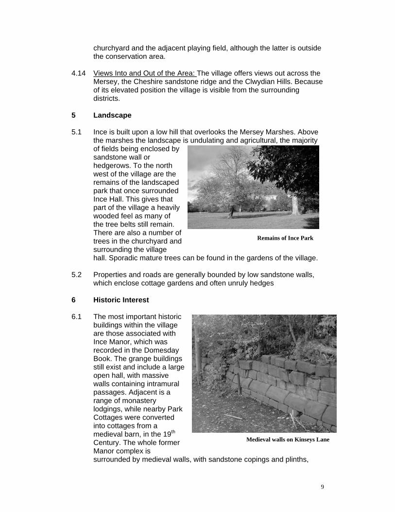
the marshes the landscape is undulating and agricultural, the majority of fields being enclosed by sandstone wall or hedgerows. To the north west of the village are the remains of the landscaped park that once surrounded Ince Hall. This gives that part of the village a heavily wooded feel as many of the tree belts still remain. There are also a number of trees in the churchyard and surrounding the village hall. Sporadic mature trees can be found in the gardens of the village.
5.2 Properties and roads are generally bounded by low sandstone walls,
which enclose cottage gardens and often unruly hedges 6 Historic Interest 6.1 The most important historic
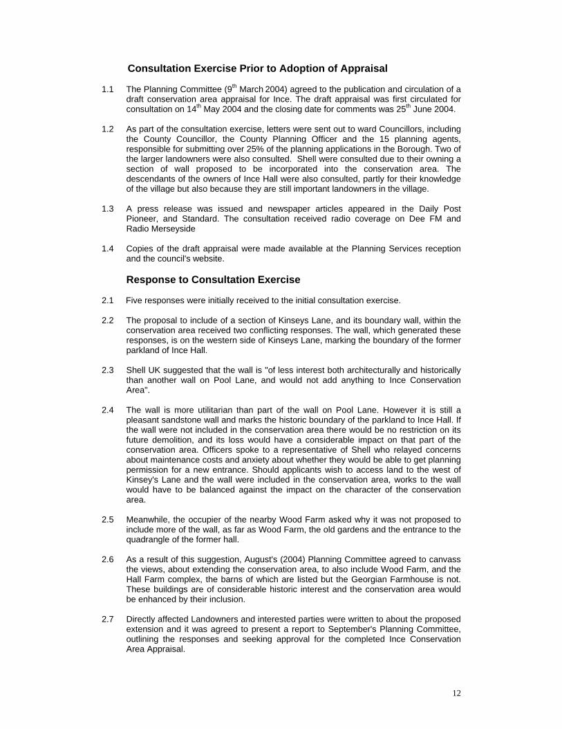
buildings within the village are those associated with Ince Manor, which was recorded in the Domesday Book. The grange buildings still exist and include a large open hall, with massive walls containing intramural passages. Adjacent is a range of monastery lodgings, while nearby Park Cottages were converted into cottages from a medieval barn, in the 19th Century. The whole former Manor complex is surrounded by medieval walls, with sandstone copings and plinths,
Remains of Ince Park
Medieval walls on Kinseys Lane

10
which can be found along Kinseys Lane, Marsh Lane and facing The Square. There was also a rock cut moat that has since been partly infilled with roads, but still exists to the east of the hall and in the gardens of Park Cottages. In the field to west of The Manor can be found the remains of dried up fishponds.
6.2 The exact number of granges that once existed is not precisely known
but is believed to have been several thousand. Only a small percentage can be accuracy located today and Ince is one of only five examples, in the north of England, of surviving standing manorial buildings, which formally belonged to an abbey. The monastery cottages are among the best-preserved examples in England, while the hall possesses the rare and unusual feature of an entrance defended against attack.
6.3 The hall of the former Manor, displays five different types of medieval
or Tudor masonry. This includes major rebuilding when the manor went out of church hands at the dissolution. It was then that the large rectangular mullioned windows were inserted into the side elevations. Internally can be found Caernarfon Arches, which derive from a design, found in Caernarfon Castle. The Caernarfon arch consists of a lintel on corbels, which are concave on the inside, and is thought to have been constructed by masons who worked on both buildings. Masons were unusually mobile around the time of the Welsh wars, due to the castle construction in North Wales. It is therefore very likely that the same masons would have worked on Ince Manor and Caernarfon Castle. The arches date from the late C13th. King Edward 1 stayed at Ince on 10/11th August 1277, after travelling from Birkenhead Priory to lay the foundation stone of Vale Royal Abbey. In 1399 the abbot and convent obtained a licence to crenellate the manor house which was confirmed in 1410.
6.4 As well as the Monastic Grange there has also been a church in the
village since Norman times. None of the Norman church survives although medieval masonry, including a C14 chancel and C15 tower, remain.
Ince Manor, Monastery Cottages

11
6.5 There are a number of other listed and historic buildings in the village notably, the parish church with its medieval chancel and tower and two Kemp windows in the chancel. However there are also a number of other buildings of various ages including a cruck framed cottage on Marsh Lane. On the side of Marsh Lane can be found the old village stocks.
6.6 For much of its history Ince was an estate village and the remnants of
the park are of importance for explaining the development of the village.
6.7 A number of important people have been associated with the village.
As well as Edward I who visited the manor in 1277, the village was also home to Rev Evan Evans, the noted Welsh poet, who was vicar at St James between 1843 and 1852. Former landowners Robert Peel and Edmund Yates were important calico printers in Blackburn. The firm of Haworth, Peel and Yates later developed mills in Bury and Tamworth. Peel's son became MP for Tamworth and his grandson was Prime Minister and founder of the Metropolitan Police.
7 The Local Economy 7.1 Farming still is the principal economic activity in the village.The Shell
refinery abuts the village, along with a number of other petrochemical enterprises. These complexes, although close, are partially screened by trees.
8 Literature Review/Sources 1. Nikolaus Pevsner and Edward Hubbard: Buildings of England, Cheshire
1971 2. Rev MK Slater: A Cheshire Parish 3. The Borough of Ellesmere Port and Neston Official Guide 1975 P47 4. TW Roberts: Ellesmere Port 1795-1960 1995 5. Patience Thompson: Ince Manor Medieval Monastic Buildings on the
Mersey Marshes Cheshire Monographs Undated 6. PJ Davey and SR Williams: Ince Manor article in Cheshire Archaeological
Bulletin No3 1975 7. Pat O'Brien: Looking Back at Ellesmere Port 1986 8. Conservation Area 16 Ince Ellesmere Port Municipal Borough Cheshire
Country Council 1970 9. Ince Manor scheduled Ancient Monument Entry Copy 10. Raymond Richards: Old Cheshire Churches 1973 11. Kelly's Directory 1896 12. List of Buildings of Architectural or Historic Interest Area of Former
Municipal Borough of Ellesmere Port 1985 13. Thornton Research Centre 50 Years: Shell Research Ltd 1990 14. Papers from Denbighshire Record Office
Catalogue of Sale, Ince Hall, Ince, Auctioneers Browns of Chester January 1936 INCE40.DOC 3.11.04
12
Consultation Exercise Prior to Adoption of Appraisal 1.1 The Planning Committee (9th March 2004) agreed to the publication and circulation of a
draft conservation area appraisal for Ince. The draft appraisal was first circulated for consultation on 14th May 2004 and the closing date for comments was 25th June 2004.
1.2 As part of the consultation exercise, letters were sent out to ward Councillors, including
the County Councillor, the County Planning Officer and the 15 planning agents, responsible for submitting over 25% of the planning applications in the Borough. Two of the larger landowners were also consulted. Shell were consulted due to their owning a section of wall proposed to be incorporated into the conservation area. The descendants of the owners of Ince Hall were also consulted, partly for their knowledge of the village but also because they are still important landowners in the village.
1.3 A press release was issued and newspaper articles appeared in the Daily Post
Pioneer, and Standard. The consultation received radio coverage on Dee FM and Radio Merseyside
1.4 Copies of the draft appraisal were made available at the Planning Services reception
and the council's website. Response to Consultation Exercise 2.1 Five responses were initially received to the initial consultation exercise. 2.2 The proposal to include of a section of Kinseys Lane, and its boundary wall, within the
conservation area received two conflicting responses. The wall, which generated these responses, is on the western side of Kinseys Lane, marking the boundary of the former parkland of Ince Hall.
2.3 Shell UK suggested that the wall is "of less interest both architecturally and historically
than another wall on Pool Lane, and would not add anything to Ince Conservation Area".
2.4 The wall is more utilitarian than part of the wall on Pool Lane. However it is still a
pleasant sandstone wall and marks the historic boundary of the parkland to Ince Hall. If the wall were not included in the conservation area there would be no restriction on its future demolition, and its loss would have a considerable impact on that part of the conservation area. Officers spoke to a representative of Shell who relayed concerns about maintenance costs and anxiety about whether they would be able to get planning permission for a new entrance. Should applicants wish to access land to the west of Kinsey's Lane and the wall were included in the conservation area, works to the wall would have to be balanced against the impact on the character of the conservation area.
2.5 Meanwhile, the occupier of the nearby Wood Farm asked why it was not proposed to
include more of the wall, as far as Wood Farm, the old gardens and the entrance to the quadrangle of the former hall.
2.6 As a result of this suggestion, August's (2004) Planning Committee agreed to canvass
the views, about extending the conservation area, to also include Wood Farm, and the Hall Farm complex, the barns of which are listed but the Georgian Farmhouse is not. These buildings are of considerable historic interest and the conservation area would be enhanced by their inclusion.
2.7 Directly affected Landowners and interested parties were written to about the proposed
extension and it was agreed to present a report to September's Planning Committee, outlining the responses and seeking approval for the completed Ince Conservation Area Appraisal.

13
2.8 The authority received two further written responses. Ince Parish Council wrote to say that they supported the extension to the conservation area.
2.9 A second response was received from the owner of Hall Farmhouse. This property is
not listed (unlike the majority of other buildings within the proposed extension) and therefore the impact of conservation area designation will be greater on occupiers of this property than others. The owners were interested to know what the impact of the conservation area would be on their possible ideas, such as a swimming pool, stable, porch, building on the land, or the introduction of wind and solar power. Officers advised the owners that, if the conservation area extension was approved, the existence of the conservation area would be a material consideration when dealing with planning applications and that other designations, notably greenbelt, would also be material when assessing planning applications.
2.10 Officers contacted Shell to ask whether they wished to add anything to their initial
objections. A representative of Shell said they did not, apart from observing that the later proposal included an even longer section of their wall.

14