Embed Size (px)
Citation preview
HYDROSTRATIGRAPHY OF THE
AIK-2448 AND AIK-2449 CORE HOLES
IN THE BREEZY HILL AREA OF
AIKEN COUNTY, SOUTH CAROLINA
STATE OF SOUTH CAROLINADEPARTMENT OF NATURAL
RESOURCES
LAND, WATER AND CONSERVATION DIVISION
WATER RESOURCESREPORT 43
2007
HYDROSTRATIGRAPHY OF THEAIK-2448 AND AIK-2449 CORE HOLES
IN THE BREEZY HILL AREA OFAIKEN COUNTY, SOUTH CAROLINA
by
Joseph A. Gellici
STATE OF SOUTH CAROLINADEPARTMENT OF NATURAL RESOURCES
LAND, WATER AND CONSERVATION DIVISION
WATER RESOURCES REPORT 43
2007
This document is available on the Department of Natural Resources web site: http://www.dnr.sc.gov/
Prepared in cooperation with the U.S. Geological Survey
STATE OF SOUTH CAROLINAThe Honorable Mark H. Sanford, Governor
South Carolina Department of Natural Resources
Board Members
Michael G. McShane, Chairman ......................................................................................................... Member-at-Large
R. Michael Campbell, II, Vice-Chairman ..............................................................................2nd Congressional District
Caroline C. Rhodes .................................................................................................................1st Congressional District
Stephen L. Davis .................................................................................................................... 3rd Congressional District
Norman F. Pulliam ..................................................................................................................4th Congressional District
Frank Murray, Jr. .....................................................................................................................5th Congressional District
John P. Evans ..........................................................................................................................6th Congressional District
John E. Frampton, Director
Land, Water and Conservation Division
Steven J. de Kozlowski, Acting Deputy Director
A.W. Badr, Ph.D., Chief, Hydrology Section
ii

CONTENTS Page
Abstract ........................................................................................................................................................................................1Introduction ..................................................................................................................................................................................1Previous work ..............................................................................................................................................................................1Nonmenclature and classification of hydrostratigraphic units .....................................................................................................3Purposes of report ........................................................................................................................................................................4Method of study ...........................................................................................................................................................................4Acknowledgments ........................................................................................................................................................................4Hydrostratigraphy ........................................................................................................................................................................4 Southeastern Coastal Plain hydrogeologic province ............................................................................................................6 Appleton confining system ............................................................................................................................................6 Gramling confining unit .........................................................................................................................................6 Stratigraphic correlation ..................................................................................................................................6 Lithology and texture ......................................................................................................................................6 Hydrologic properties......................................................................................................................................6 Geophysical-log signature ...............................................................................................................................8 Floridan-Midville aquifer system ..................................................................................................................................8 McQueen Branch aquifer unit ................................................................................................................................8 Stratigraphic correlation ..................................................................................................................................8 Lithology and texture ......................................................................................................................................8 Hydrologic properties....................................................................................................................................10 Geophysical-log signature .............................................................................................................................10 Clay beds of the McQueen Branch confining unit ...............................................................................................10 Stratigraphic correlation ................................................................................................................................10 Lithology and texture ....................................................................................................................................10 Hydrologic properties....................................................................................................................................10 Geophysical-log signature .............................................................................................................................11 Crouch Branch aquifer unit ..................................................................................................................................11 Stratigraphic correlation ................................................................................................................................11 Lithology and texture ....................................................................................................................................12 Hydrologic properties....................................................................................................................................12 Geophysical-log signature .............................................................................................................................12 Steed Pond aquifer unit ........................................................................................................................................12 Stratigraphic correlation ................................................................................................................................12 Lithology and texture ....................................................................................................................................13 Hydrologic properties....................................................................................................................................13 Geophysical-log signature .............................................................................................................................13Hydrogeologic sections ..............................................................................................................................................................13 Hydrogeologic Section A-A′ ...............................................................................................................................................15 Hydrogeologic Section B-B′ ...............................................................................................................................................16Discussion ..................................................................................................................................................................................16References ..................................................................................................................................................................................19Appendix I – Description of core AIK-2448 ............................................................................................................................22Appendix II – Description of core AIK-2449 ...........................................................................................................................25
iii
FIGURES Page
1. Map showing location of core holes AIK-2448 and AIK-2449 and section lines A-A′ and B-B′ ....................................2 2. Generalized description of hydrostratigraphic units delineated in Aiken core holes and comparison with hydrostratigraphic units of Aucott and others (1987), Miller and Renken (1988), and with lithostratigraphic units of Colquhoun and others (1983)..........................................................5 3. Hydrostratigraphic correlation between AIK-2448 and AIK-2449 ...................................................................................7 4. Generalized hydrostratigraphy of area showing nomenclatural changes in the updip regions .........................................9 5. Stratigraphy of C-2 (AIK-817) well cluster/core site in Aiken County ..........................................................................17 6. Drainage basins of Aiken County ...................................................................................................................................18
TABLE
Baseline stratigraphic data used in this report.................................................................................................................14
PLATES
1. Stratigraphy, geophysical logs, and lithology of core holes AIK-2448 and AIK-2449 2. Hydrogeologic section A-A′, Breezy Hill area to SRS 3. Hydrogeologic section B-B′, Breezy Hill area to Orangeburg
iv
�
HYDROSTRATIGRAPHY OF THE AIK-2448 AND AIK-2449 CORE HOLESIN THE BREEZY HILL AREA OF AIKEN COUNTY, SOUTH CAROLINA
byJoseph A. Gellici
ABSTRACT
Hydrostratigraphic units in the updip region of the South Carolina Coastal Plain are delineated by using lithological, hydrological, and geophysical data from two continuously cored boreholes in Aiken County, S.C. Aquifers are 33 to �46 feet thick and, in ascending order, include the McQueen Branch, Crouch Branch, and Steed Pond. They consist of unconsolidated quartz-sand beds of Upper Cretaceous through Miocene age. Confining units are 13 to 34 feet thick and, in ascending order, include the informally named Gramling and the previously named McQueen Branch. They consist of silty clay beds of Upper Cretaceous age and saprolite of Paleozoic age. Hydrogeologic sections illustrate the thickness, lateral continuity, and geographic limits of the units in Aiken County. Hydrostratigraphic units are correlated with those mapped at the Savannah River Site to the south and with those mapped in Orangeburg County to the east.
INTRODUCTION
During the period from �995 to 2000, the South Carolina Department of Natural Resources (SCDNR) and the U.S. Geological Survey (USGS) collaborated on a drilling project and scientific study to collect subsurface data in order to reevaluate the stratigraphy of the South Carolina Coastal Plain and improve our knowledge of the hydrogeologic framework. More than �0,000 ft (feet) of core was collected from �9 core holes; �6 monitor wells were installed; about 700 paleontological samples were analyzed; and over 90 geophysical logs were made. The project was not completed, owing to a change in research priorities by the USGS. Although large amounts of data were collected and analyzed, few reports were written. Scientists originally involved in the project had other obligations and several have since retired. This is the second of what will, expectedly, be a series of reports examining the hydrostatigraphic framework of the Coastal Plain in light of some of the previously unpublished data obtained from the cores. The first report written in this series was: Gellici, J.A., 2007, Hydrostratigraphy of the ORG-393 core hole at Orangeburg, South Carolina, South Carolina Department of Natural Resources Water Resources Report 42, 3� p.
The USGS Eastern Earth Surface Processes Team, using a wireline drilling system, drilled two core holes in the Coastal Plain province in Aiken County, S.C. AIK-2448 was drilled in October �998 about �0 mi (miles) northwest of Aiken. AIK-2449, also drilled in October �998, is about �0 mi west of Aiken (Fig. �). A Global Positioning System (GPS) unit with a horizontal accuracy of about 30 ft (feet) was used to acquire the latitude and longitude coordinates of each well. AIK-2248 is at latitude 33º 37′ 28″ N and longitude 81º 50′ 59″ W, and AIK-2449, which is 5.9 mi south of AIK-2448, is at latitude 33º 32′ 22″ N and longitude 81º 51′ 18″ W. Land-surface elevation is +490 ft msl (feet above mean sea level) at AIK-2448 and +494 ft msl at AIK-2449, as estimated from topographic maps using the �927 North American datum.
AIK-2448 was continuously cored to a depth of �70 ft and AIK-2449 to 340 ft. The cores are stored (as of June 2007) at the South Carolina Geological Survey core repository at 5 Geology Road, Columbia, S.C. AIK-2448 and AIK-2449, respectively, penetrated �2�.5 and 3�3 ft of poorly consolidated Cretaceous and Cenozoic Coastal Plain sediments and 48.5 and 26.5 ft of saprolite and saprock. Hydrostratigraphic units delineated in the cores are described herein, and hydraulics data are provided where available. Units are correlated with those described at the Savannah River Site (SRS) by Aadland and others (�995) and with those delineated in nearby core holes. Reported footages are relative to land surface unless otherwise noted, and boundaries of hydrostratigraphic units are reported to the nearest foot.
PREVIOUS WORK
The two core holes analyzed for this report were drilled to study the ground-water resources of the Breezy Hill area in northern Aiken County. As a result, two reports have been published that utilized the cores to characterize the local hydrogeology of the area: Krambis (2000) used the cores in support of his MS thesis at Clemson University to help build a hydrogeologic framework for a numerical ground-water flow model that he developed for the area and to determine hydraulic properties of aquifers and confining units from laboratory analyses of the cores; Harrelson and others (2002) used the cores to develop a hydrogeologic framework of the area in order to describe the configuration of the water table and to determine the saturated thickness of the principal aquifer in the area.
Numerous core holes have been drilled in Aiken County over the past 25 years, most of them at SRS (see Aadland and others, �995, and Bledsoe, �984, �987, and �988). Some of the more significant cores at SRS were obtained as part of the so-called “P-well” drilling program, which involved the drilling of continuous core holes and monitor wells inside the boundaries of SRS during the �980’s primarily

2
Figure 1. Location of core holes AIK-2448 and AIK-2449, other significant core holes in Aiken County,and hydrogeologic section lines A-A′ and B-B′.
!
!
!!
!
!
!
!
!
!
!
!
!
§̈¦26
§̈¦95
Aiken
Jackson
New Ellenton
North Augusta
Perry
Salley
Wagener
Windsor
Monetta
Orangeburg
Branchville
Santee
Neeses
North
Holly Hill
SpringfieldElloree
Bowman
Norway
Eutawville
Woodford
Vance
Livingston
RowesvilleCope
£¤78
£¤1
£¤278
£¤178
£¤301
£¤21
£¤15
£¤601
miles
AIK-826
AIK-2448
AIK-2449
AIK-2450
AIK-817
AIK-643
BRN-335
ORG-393
AIK-892
AIK-878
AIK-872
AIK-865
AIK-902
Barnwell
Williston
Elko
Hilda
Kline
Blackville
Snelling
§̈¦20
SavannahRiverSite
ORANGEBURGCOUNTY
AIKENCOUNTY
BARNWELLCOUNTY
N
0 5 10 20 30 40
A'
A
BB'
S o u t hC a r o l i n a

3
for hydrostratigraphic studies (Fig. �). Core hole P-�6 (AIK-643) was drilled in �985 to a depth of 660 ft (Bledsoe, �987); P-26 (AIK-872) was drilled in �986 to a depth of 685 ft (Bledsoe, �988); P-28 (AIK-878) was drilled in �986 to a depth of 840 ft (Bledsoe, �988); P-29 (AIK-865) was drilled in �986 to a depth of 805 ft (Bledsoe, �988); and P-30 (AIK-892) was drilled in �986 to a depth of 800 ft (Bledsoe, �988). Other core holes, too numerous to cite here, were also drilled at SRS in Aiken County, most to address site-specific studies in the A-M Area and in the General Separations Area of SRS.
Other significant cores in the county are located north of SRS and were drilled as part of the so-called “C-well” drilling program, which involved obtaining continuous cores and installing monitor wells just outside the boundaries of SRS during the late �980’s and early �990’s—also for hydrostratigraphic studies (Fig. �). Core hole C-2 (AIK-8�7) was drilled in 1987 to a depth of 561 ft (Logan, 1987); C-3 (AIK-826) was drilled in �988 to a depth of 540 ft (Kuntz and Griffin, 1988); and C-1 (AIK-902) was drilled in 1992 to a depth of 575 ft (Gellici and others, �995).
The two cores examined in this report are significant because they are located farther updip than other cores in the county. They are key test holes for understanding the hydrostratigraphic framework in areas where the Coastal Plain sequence thins and where topography has a major influence on ground-water flow and availability. In these areas, confining units are thin and discontinuous, pinch out in the subsurface, and are breached by streams. Aquifers are deeply incised by streams creating deep water tables and unconfined conditions. These core holes are also important for understanding hydrostratigraphic relationships between unconfined aquifers in updip areas and their correlative units in downdip areas where the aquifers are confined.
Numerous studies have described the hydrostratigraphy of the county. Siple (1967) provided the first comprehensive ground-water study of the area. Colquhoun and others (�983) presented lithostratigraphic sections that traverse the county and also included a generalized delineation of the major aquifer systems. Aucott and others (�987) mapped the hydrogeologic units of the South Carolina Coastal Plain, including those of Aiken County. Miller and Renken (�988) mapped hydrogeologic units of the Southeastern Coastal Plain aquifer systems from Mississippi to North Carolina. Logan and Euler (1989) reported on the ground-water resources of the southern part of Aiken County. Newcome (�989) gave an overview of the ground-water resources of the South Carolina Coastal Plain, including hydrologic characteristics of aquifers in each county. Aadland and others (�995) provided a detailed hydrostratigraphic framework of the SRS area and introduced a new aquifer nomenclature and classification scheme. Falls and others (1997) presented a detailed hydrostratigraphic framework and geologic description of the SRS area for a ground-water flow model study. Newcome (�993 and 2005) analyzed and compiled pumping-test data from wells in the Coastal Plain, including 38 tests in Aiken County.
NOMENCLATURE AND CLASSIFICATIONOF HYDROSTRATIGRAPHIC UNITS
Hydrostratigraphic nomenclature and the classification
of hydrostratigraphic units as provinces, systems, units, and zones is adopted from Aadland and others (�995) and conforms to guidelines established by the U.S. Geological Survey (Laney and Davidson, 1986) and the South Carolina Hydrostratigraphic Subcommittee (Burt, �987a and b). Topping the classification hierarchy (level 1) are hydrogeologic provinces, which define major regional rock or sediment packages that behave as a single unified hydrologic unit. The two hydrogeologic provinces in South Carolina are the Southeastern Coastal Plain hydrogeologic province and the Piedmont hydrogeologic province (Aadland and others, 1995). Ranked at level 2 are aquifer and confining systems. Aquifer systems are composed of a single aquifer or two or more aquifers that transmit water on a regional scale. Confining systems are composed of a single confining unit or two or more confining units that impede regional ground-water flow.
The building blocks of the classification system are aquifer units and confining units (level 3). As defined by the subcommittee, an aquifer is a mappable (>400 mi2, square miles) body of rock or sediments that is sufficiently permeable to conduct ground water and yield significant quantities of water to wells and springs (Bates and Jackson, �980). A confining unit is a mappable (>400 mi2) body of rock or sediments of significantly lower hydraulic conductivity than an adjacent aquifer and is an impediment to ground-water flow into or out of an aquifer (Lohman and others, 1972).
Aquifer and confining systems and units are formally named for a geographic or cultural feature that is located near a designated type-well locality where the system or unit is representative and well defined. For example, the McQueen Branch aquifer is named after McQueen Branch, which is a tributary of Upper Three Runs and is located near type-well P-27 at SRS. Confining units carry the name of the underlying aquifer that they confine.
In areas where a confining unit pinches out and two aquifers coalesce, a new name is given to the aquifer. In areas where a confining system thins and no longer regionally separates the overlying and underlying aquifer systems, a single aquifer system is defined and named by combining the names of the two coalescing aquifer systems (Aadland and others, �995). Where aquifer systems have combined, the individual aquifer and confining units can and commonly do extend into and form part of the combined system (Aadland and others, �995).
Aquifer and confining units can be informally subdivided into zones (level 4) that are characterized by properties significantly different from the rest of the unit, such as hydraulic conductivity, water chemistry, lithology, or color. Names of aquifer and confining zones are informal and describe the unique property that differentiates the zone from the rest of the unit. Zones are locally defined and, as such, their names should be used only at the site where

4
they were defined. No association or correlation is implied between zones of the same name that were defined at different locations. For example, the “high-permeability zone” of the McQueen Branch aquifer delineated at Orangeburg may be defined differently than the “high-permeability zone” of the McQueen Branch aquifer delineated at Allendale. Furthermore, lateral hydraulic continuity is not implied between zones of the same name that were defined at different sites.
PURPOSES OF REPORT
The purposes of this report are: �) to delineate the major hydrostratigraphic units at the AIK-2448 and AIK-2449 core holes; 2) to relate the units to allostratigraphic formations and to other hydrostratigraphic frameworks; 3) to characterize the units in terms of their lithologic, hydrologic, and geophysical properties; 4) to correlate the units with those at other core holes and water wells in Aiken County; 5) to correlate the units with those defined at SRS and at Orangeburg; and 6) to extend to the updip regions of Aiken County the hydrostratigraphic nomenclature and hierarchical classification scheme that was introduced at SRS.
METHOD OF STUDY
In previous hydrogeologic-framework studies, investi-gators had to rely mainly on geophysical logs and drill cuttings from water wells and from a few test holes to delineate hydrogeologic units and to correlate them across the Coastal Plain. Cores were generally unavailable because of their high costs. One of the benefits of a core is that it can be visually examined, and samples from known depths can be dated and analyzed. Cores drilled continuously to bedrock permit for an entire stratigraphic sequence of the Coastal Plain to be observed, studied, and related to other cores, drill cuttings, and outcrops to improve our knowledge of the stratigraphic framework. Cores are also useful in ground truthing geophysical logs, thereby improving delineation and correlation with water wells that have geophysical logs but have not been cored.
In this study, two continuous cores from land surface to bedrock were collected in 5- and �0-ft sections. Cores were described (by Dr. David C. Prowell of the USGS) in terms of their lithology, grain size, sorting, induration, mineralogy, fossils, structures, and color (see Appendices and Plate �). Cores were then boxed and photographed. A suite of geophysical logs was obtained from each borehole after the cores were collected. Logs included 16- and 64-inch short- and long-normal resistivity, spontaneous-potential, gamma-radiation, and single-point resistance (Plate �).
Paleontologists with the USGS and Clemson University sampled the cores and microscopically examined them for palynomorphs (pollen and spores from terrestrial plants and cysts of dinoflagellates) but found no diagnostic fossil assemblages from either core. As such, no biostratigraphic data are available for these cores.
Unconformity-bounded geologic formations (allostrati-graphic units) were initially identified in the cores by noting lithologic and textural changes, irregular contacts, and by the identification of transgressive lag deposits. Lag deposits in updip regions typically consist of beds of poorly sorted sand and gravel. Final determinations were made on formation boundaries by using the occurrence of lag deposits and lithologic data in combination with borehole geophysical data and by correlation with nearby cores and outcrops that had biostratigraphic control.
Permeable and impermeable layers were differentiated by visual inspection of the cores and by an analysis of the borehole geophysical logs. Permeable layers were assigned to aquifers and impermeable layers to confining units. Allostratigraphic and geophysical data were used to correlate the aquifers and confining units with those at SRS where vertical hydraulic-head data from well-cluster sites are available and where a detailed hydrostratigraphic framework has been developed (Aadland and others, �995).
ACKNOWLEDGMENTS
Funding for the project was provided by Aiken County and through the National Geologic Cooperative Mapping Program. David C. Prowell (USGS) initiated the study, coordinated the drilling activities, described the cores, and determined allostratigraphic and geologic contacts. Karen E. Agerton (SCDNR) assisted in the collection and description of the cores. Eugene Cobbs, II, and Eugene Cobbs, III (both of the USGS), drilled the core holes and constructed the monitor wells. The author acknowledges the unique talents of these individuals and extends his gratitude for the expertise that each brought to the project.
HYDROSTRATIGRAPHY
Two hydrostratigraphic systems of the Southeastern Coastal Plain hydrogeologic province are delineated in the AIK-2448 and AIK-2449 core holes—the basal Appleton confining system and the Floridan-Midville aquifer system (Fig. 2 and Plate 1). The Appleton confining system consists of a single unit that is informally named the Gramling confining unit (Gellici, 2007). Although both core holes penetrated rocks of the Piedmont province, neither was drilled deep enough to extend entirely through saprolite and into unweathered bedrock of the Piedmont hydrogeologic province. The Piedmont province refers to unweathered rocks of Paleozoic and Triassic age (Aadland and others, �995); it does not include the saprolitic zone. Saprolite is in the Appleton confining system, which is part of the Southeastern Coastal Plain hydrogeologic province, as described below.
The Floridan-Midville aquifer system is the combined Floridan, Dublin, and Midville aquifer systems of Aadland and others (�995). It consists of the three aquifers—McQueen Branch, Crouch Branch, and Steed Pond (Fig. 2).
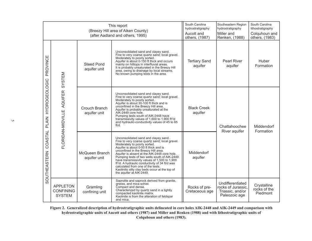
5
Figure 2. Generalized description of hydrostratigraphic units delineated in core holes AIK-2448 and AIK-2449 and comparison with hydrostratigraphic units of Aucott and others (1987) and Miller and Renken (1988) and with lithostratigraphic units of
Colquhoun and others (1983).
SO
UTH
EA
STE
RN
CO
AS
TAL
PLA
IN H
YD
RO
GE
OLO
GIC
PR
OV
INC
E
FLO
RID
AN
-MID
VIL
LE A
QU
IFE
R S
YS
TEM
APPLETONCONFINING
SYSTEM
This report
ChattahoocheeRiver aquifer
Gramlingconfining unit
McQueen Branchaquifer unit
Crouch Branchaquifer unit
Black Creekaquifer
Crystalline rocks of the
PiedmontRocks of pre-
Cretaceous age
Middendorfaquifer
Steed Pondaquifer unit
Pearl Riveraquifer
MiddendorfFormation
HuberFormation
Tertiary Sandaquifer
Aucott and others, (1987)
Colquhoun and others, (1983)
South Carolinahydrostratigraphy
Miller and Renken, (1988)
Southeastern Regionhydrostratigraphy
South Carolinalithostratigraphy(Breezy Hill area of Aiken County)
(after Aadland and others, 1995)
Unconsolidated sand and clayey sand. Fine to very coarse quartz sand; local gravel.Moderately to poorly sorted.Aquifer is about 0-150 ft thick and occursmainly on hilltops in interfluvial areas.It is probably unsaturated in the Breezy Hillarea, owing to drainage by local streams.No known pumping tests in the area.
Unconsolidated sand and clayey sand. Fine to very coarse quartz sand; local gravel.Moderately to poorly sorted.Aquifer is about 30-100 ft thick and isunconfined in the Breezy Hill area.Aquifer is probably unsaturated at the AIK-2449 core hole. Pumping tests south of AIK-2448 havetransmissivity values of 1,600 to 1,900 ft2/dand hydraulic-conductivity values of 45 to 65 ft/d.
Unconsolidated sand and clayey sand. Fine to very coarse quartz sand; local gravel.Moderately to poorly sorted.Aquifer is about 0-50 ft thick and isunconfined in the Breezy Hill area.Aquifer is absent at the AIK-2448 core hole. Pumping tests of two wells south of AIK-2449 have transmissivity values of 1,500 to 1,900ft2/d. A hydraulic conductivity of 34 ft/d wascalculated from one of the tests.Kaolinitic silty clay beds occur at the top ofthe aquifer at AIK-2449.
Saprolite and saprock derived from granite,gneiss, and mica schist.Compact and dense. Characterized by quartz sand in a tightly compacted kaolinite matrix.Kaolinite is from the alteration of feldsparand mica.
Undifferentiatedrocks of Jurassic,Triassic, and/orPaleozoic age

6
Southeastern Coastal Plain Hydrogeologic Province
The Southeastern Coastal Plain hydrogeologic province in South Carolina encompasses an area of about 22,500 mi². About 95 percent of the State’s ground-water resources are in the province (Newcome, �989). It consists of a hydraulically complex sequence of Mesozoic and Cenozoic sedimentary units that are composed of unconsolidated to semiconsolidated layers of sand, clay, limestone, and marl. The province thickens from zero at the Fall Line to a maximum of about 4,000 ft at the southern part of the State.
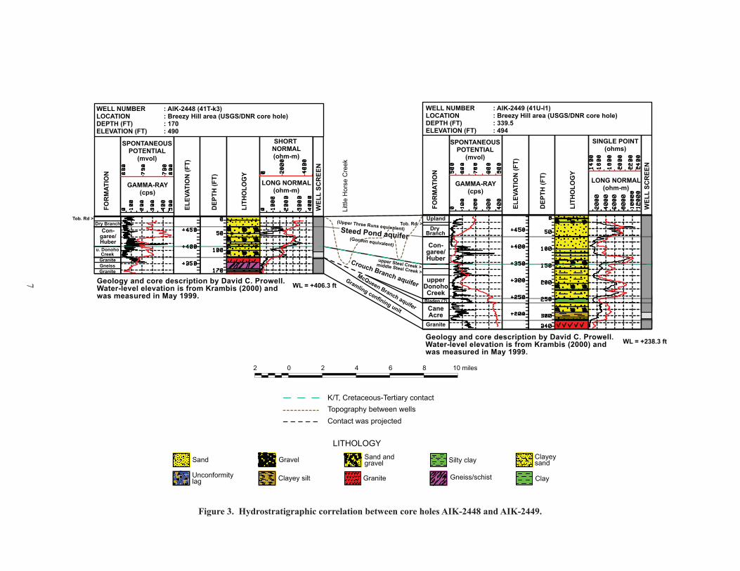
The AIK-2448 core hole penetrated �2�.5 ft of Coastal Plain sediments. It also penetrated 48.5 ft of saprolite, which forms the Gramling confining unit at the core hole. The AIK-2449 core hole penetrated 3�3 ft of Coastal Plain sediments and 26.5 ft of saprolite. Visual examinations of the cores and geophysical logs, along with hydrologic data such as transmissivity and hydraulic-conductivity values from pumping tests and vertical hydraulic-head differences, were used to delineate and characterize the principal hydrostratigraphic units in the province (Fig. 3 and Plate �).
Appleton Confining System
The Appleton confining system is the lowermost confining system of the Southeastern Coastal Plain hydrogeologic province. In updip areas, it hydraulically separates Coastal Plain sediments from underlying basement rocks; in downdip areas, it overlies and confines a deep Cretaceous aquifer. Across most of the Coastal Plain, the system is correlated with the Black Warrior River confining unit of Miller and Renken (�988) (Fig. 2). In updip areas, where the system consists only of saprolite, it is correlated with Miller and Renken’s basement rocks that they designate as “undifferentiated rocks of Jurassic, Triassic, and Paleozoic age.”
The system was defined at cluster site C-10 (well ALL-348) at Appleton, S.C., where it is 237 ft thick and consists of saprolite derived from igneous rock and of interbedded sand, clayey sand, and clay of the basal Cape Fear Formation (Aadland and others, �995). Mapping by the author indicates that it underlies the entire Coastal Plain, although it thins considerably in the northwest corner where it consists only of saprolite. Permeable beds occur in the system but are thought to be of limited lateral extent. At both core holes of the present report, the system contains only what is, herein, informally called the “Gramling confining unit.” Gramling confining unit
The Gramling confining unit is the lowermost confining unit in the area (Fig. 3 and Plate �). It overlies the Piedmont hydrogeologic province and underlies the McQueen Branch aquifer. In the AIK-2448 core hole, the unit occurs from �22 to �70 ft and is 48 ft thick. It consists of saprolite and saprock derived from granite, gneiss, and schist. In the AIK-2449 core, the unit occurs from 3�3 to 340 ft, is 27 ft thick, and consists of saprolite and saprock derived from granite.
Saprolite is highly weathered bedrock; saprock is slightly weathered bedrock and is transitional between saprolite and unweathered (fresh) bedrock.
Stratigraphic correlation.—In most areas of the Coastal Plain, the lowermost confining unit (Gramling equivalent) consists of both saprolite and the lower part of the overlying Cape Fear Formation (Upper Cretaceous, Turonian through Coniacian, corresponding to calcareous nannofossil zones CC�2-�3 of Perch-Nielsen, �979). At these two core holes, however, the Cape Fear Formation is absent, due either to erosion or to nondeposition, and the confining unit consists only of clay-rich weathered bedrock (saprolite and saprock) of Paleozoic age.
The Gramling confining unit is correlated with the “unnamed” basal confining unit of Aadland and others (1995) and with the basal confining unit of Falls and others (�997). It was mapped as “crystalline rocks of the Piedmont” by Colquhoun and others (�983; see the Belvedere well on section E-E′, p. 27) and is generally correlated with the lowermost, unnamed confining unit of Aucott and others (1987; see well AK-266 of section H-H′ on Sheet 7). Aucott, however, did not extend the confining unit this far updip, pinching it out in the SRS region.
Lithology and texture.—At the AIK-2448 core hole, the confining unit consists of highly weathered (saprolite) granite, gneiss, and mica schist (�22 to �59 ft) and moderately weathered (saprock) gneiss and granite (�59 to �70 ft) (see Appendix I and Plate �). The saprolitic zone is 50 to 65 percent feldspar (weathered to kaolinite), about 30 percent coarse to very coarse quartz grains, and 5 to 20 percent mica. The core is compact and dense with sparse quartz veins and several slickensided surfaces. Zones as thick as 3 ft consist of mica schist, locally fractured and jointed.
The saprock interval is less weathered and consists of 35 to 55 percent feldspar (mostly weathered to kaolinite), 35 percent medium to coarse quartz grains, and up to 30 percent mica. Thin (�0 to 25 mm) veins cut the core at low angles (0 to �0 degrees).
At the AIK-2449 core hole, the confining unit consists of highly weathered (saprolite) granite (3�3 to 334 ft) and denser, less weathered (saprock) granite (334 to 340 ft) (see Appendix II and Plate �). Both zones consist of about 60 percent feldspar (weathered to kaolinite), 35 percent coarse to very coarse quartz grains, and 5 percent mica. The unit is indurated. Horizontal fractures, which may be induced from drilling, occur every �½ to 2 ft in the interval from 322 to 327 ft. Several clay-filled high-angle fractures also occur in the unit.
Hydrologic properties.—A flexible-wall permeability test of a saprolite sample at AIK-2449 (323 to 334 ft) indicates a vertical hydraulic conductivity of �.3x�0-5 cm/s (3.7x�0-2 ft/d, feet per day) (Krambis, 2000; see his Appendix A). Laboratory tests of 12 saprolite samples taken from cores at SRS indicate a range of vertical hydraulic conductivity from �.4x�0-2 to 6.2x�0-5 ft/d, averaging 2.6x�0-3 ft/d (Marine, �979). Porosities of these same samples range from 7.7 to 53.5 percent and average 35.� percent.
7
Figure 3. Hydrostratigraphic correlation between core holes AIK-2448 and AIK-2449.
WELL NUMBER : AIK-2448 (41T-k3)LOCATION : Breezy Hill area (USGS/DNR core hole)DEPTH (FT) : 170ELEVATION (FT) : 490
SPONTANEOUSPOTENTIAL
(mvol)
GAMMA-RAY(cps)
SPONTANEOUSPOTENTIAL
(mvol)
GAMMA-RAY(cps)
LONG NORMAL(ohm-m)
LONG NORMAL(ohm-m)
SHORT NORMAL(ohm-m)
FOR
MAT
ION
ELEV
ATIO
N (F
T)
DEP
TH (F
T)
WEL
L SC
REE
N
LITH
OLO
GY
FOR
MAT
ION
ELEV
ATIO
N (F
T)
DEP
TH (F
T)
WEL
L SC
REE
N
LITH
OLO
GY
Tob. Rd >
Granite
Granite
GraniteGneiss
Dry BranchCon-
garee/Huber Con-
garee/Huber
CaneAcre
Dry Branch
Tob. Rd. >
Bladen (?)
upper Steel Creek >middle Steel Creek >
Upland
u. DonohoCreek
upperDonohoCreek
SINGLE POINT(ohms)
McQueen Branch aquifer
Crouch Branch aquifer
Steed Pond aquifer (Gordon equivalent)
(Upper Three Runs equivalent)
Gramling confining unit
WL = +406.3 ftGeology and core description by David C. Prowell.Water-level elevation is from Krambis (2000) andwas measured in May 1999.
Littl
e H
orse
Cre
ek
WELL NUMBER : AIK-2449 (41U-l1)LOCATION : Breezy Hill area (USGS/DNR core hole)DEPTH (FT) : 339.5ELEVATION (FT) : 494
LITHOLOGYClayeysand
Clay
Sand andgravelSand
GraniteClayey silt
Silty clayGravel
Unconformitylag Gneiss/schist
0 2 4 6 8 10 miles2
Topography between wellsContact was projected
K/T, Cretaceous-Tertiary contact
Geology and core description by David C. Prowell.Water-level elevation is from Krambis (2000) andwas measured in May 1999.
WL = +238.3 ft

8
Geophysical-log signature.—Low resistivity and high gamma radiation values reflect the high clay content of the confining unit (Plate 1). Resistivity measured by the long-normal electric log averages about 250 ohm-meters at AIK-2448 and 380 ohm-meters at AIK-2449. Fresh granite, by comparison, has a resistivity greater than �,000 ohm-meters (Hilchie, �982). Radiation averages about �40 cps (counts per second) at each core hole.
Floridan-Midville Aquifer System
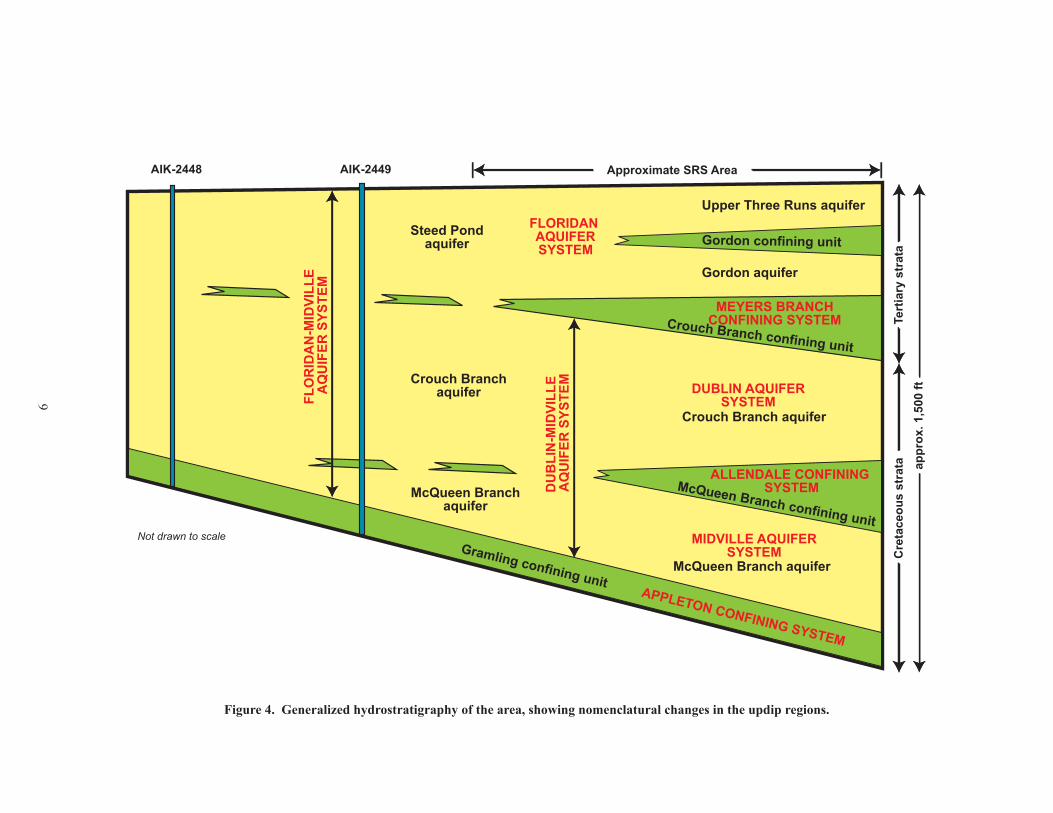
In the southern part of SRS, the Cretaceous section consists of two aquifer systems, the Midville and Dublin, separated by the Allendale confining system (Fig. 4). The Midville consists of a single aquifer called the McQueen Branch, and the Dublin consists of a single aquifer called the Crouch Branch. In the central part of SRS, clay beds of the Allendale confining system thin and no longer regionally separate the two aquifer systems. A new system defined is called the Dublin-Midville aquifer system (Aadland and others, �995).
In the southern part of SRS, the Tertiary section consists of a single aquifer system, the Floridan, separated from the underlying Dublin system by the Meyers Branch confining system (Fig. 4). The Floridan consists of two aquifers, the Gordon and the Upper Three Runs, that are separated by marl and clay beds of the Gordon confining unit. In the northern part of SRS, clay beds of the Meyers Branch confining system thin and no longer separate the two systems. Here, the Floridan combines with the Dublin-Midville and forms the Floridan-Midville aquifer system (see Figure �0 on page 26 in Aadland and others, �995).
The Floridan-Midville aquifer system is defined by the hydrogeologic properties of sediments penetrated in the ASB-8/MSB-�2 type well located in A-M Area in the northwest corner of SRS (Aadland and others, �995). There, the system is 557 ft thick and includes all sediments from the water table to the top of the Appleton confining system. It includes three aquifers that, in ascending order, are the McQueen Branch, Crouch Branch, and Steed Pond that are locally separated by clay beds. Aquifers of the Floridan-Midville system are, for the most part, hydraulically connected owing to the thin and laterally discontinuous nature of the confining beds, to faulting that breaches the confining beds, and to erosion by local stream systems that dissect the interval (Aadland and others, �995). The system can be correlated with the Chattahoochee River and Pearl River aquifers of Miller and Renken (�988) (Fig. 2).
McQueen Branch aquifer unitThe McQueen Branch aquifer is the lowermost aquifer
in the study area (Fig. 3 and Plate �). It overlies the Gramling confining unit and is overlain by clay beds equivalent to the downdip McQueen Branch confining unit. At the AIK-2449 core hole, the aquifer occurs from 26� to 3�3 ft and is 52 ft thick. It consists of unconsolidated clayey sand and gravel of Upper Cretaceous age. A bed of poorly sorted quartz sand
and gravel overlies highly weathered granite (saprolite) and marks the contact between the aquifer and the underlying Gramling confining unit. At the AIK-2448 core hole, the aquifer is absent owing to erosion or nondeposition.
Stratigraphic correlation.—At core hole AIK-2449, the aquifer consists only of the Cane Acre Formation (lower Campanian, corresponding to calcareous nannofossil zone CC-�9; Plate �), which is the lowermost formation of the Black Creek Group. (See Gohn, �992, and Gohn and Campbell, �992, for a lithologic and biostratigraphic description of the Cane Acre Formation.) Other formations that commonly compose part of the aquifer, such as the Cape Fear and Coachman Formations (Gellici, 2007), are thought to be absent in these updip regions of the Coastal Plain owing to erosion or to nondeposition.
Lacking biostratigraphic data, correlation with the Cane Acre Formation is questionable and is based primarily on lithologic data from the core, borehole geophysical data, and extrapolation to other core holes. Krambis (2000) considered the aquifer to be correlated with the Cape Fear Formation (Turonian through Coniacian, corresponding to calcareous nannofossil zones CC�2-�3). Harrelson and others (2002) were uncertain about its age but believed it to be part of the Black Creek Group. They called it “Middendorf Formation” using quotes to indicate that the name had been incorrectly applied in the past (see Prowell and others, 2003) and that a new name was needed.
Gohn (1992) defined the Cane Acre Formation in the USGS-Clubhouse Crossroads #� core (DOR-37) and assigned a lower Campanian age to the formation (calcareous nannofossil zone CC-�9). It is the lowermost formation of the Black Creek Group. In previous reports (Colquhoun and others, �983; Aucott and others, �987; Aadland and others, �995), the basal Cretaceous formation in updip regions of the Coastal Plain was mapped as the Middendorf Formation (Santonian). Recent studies of cores and outcrops (Prowell and others, 2003, and Gellici, 2007) indicate that strata previously mapped as the Middendorf Formation are probably lower Campanian and equivalent to the Cane Acre Formation.
The McQueen Branch aquifer at AIK-2449 is correlated with the McQueen Branch aquifer mapped in west-central South Carolina by Aadland and others (�995) and with the lower Midville aquifer of Falls and others (�997). To some extent it is also correlated with the Lower Middendorf aquifer and the Middendorf Formation of Colquhoun and others (1983; see the Belvedere well on section E-E′, p. 27) and with the Middendorf aquifer of Aucott and others (�987; see well AK-266 of section H-H′ on Sheet 7).
Lithology and texture.—The aquifer is characterized by unconsolidated, moderately to poorly sorted, fine to very coarse quartz sand and gravel in a kaolin clay matrix (Plate 1 and Appendices). Six fining-upwards sequences from 6 to �2 ft thick compose the aquifer. These sequences consist of clayey coarse sand and gravel at the base and very fine to medium clayey sand or silty clay at the top. Locally, the aquifer contains common kaolin balls/clasts up to 40 mm in
9
Figure 4. Generalized hydrostratigraphy of the area, showing nomenclatural changes in the updip regions.
FLORIDAN AQUIFER SYSTEM
DUBLIN AQUIFERSYSTEM
MEYERS BRANCHCONFINING SYSTEM
ALLENDALE CONFINING SYSTEM
MIDVILLE AQUIFERSYSTEM
DU
BLI
N-M
IDVI
LLE
AQ
UIF
ER S
YSTE
M
FLO
RID
AN
-MID
VILL
E A
QU
IFER
SYS
TEM
Upper Three Runs aquifer
Gordon aquifer
Steed Pondaquifer
Crouch Branch aquifer
Gordon confining unit
McQueen Branch confining unit
Crouch Branchaquifer
McQueen Branch aquifer
McQueen Branchaquifer
AIK-2448 AIK-2449
Gramling confining unit
Crouch Branch confining unit
Approximate SRS Area
Tert
iary
str
ata
appr
ox. 1
,500
ftC
reta
ceou
s st
rata
Not drawn to scale
APPLETON CONFINING SYSTEM

�0
diameter and gravel up to 25 mm. Cross-beds are common throughout the aquifer. Several sand beds have little to no clay matrix whereas others have up to 30 percent matrix.
Hydrologic properties.—The aquifer is unconfined at AIK-2449, as reported by Krambis (2000) and Harrelson and others (2002), who did detailed hydrologic studies of the region. Clay beds of the overlying McQueen Branch confining unit are present at AIK-2449 but are laterally discontinuous and do not confine the aquifer. The core hole is located in an interfluvial area (on a ridge) bounded by Little Horse Creek to the west and Horse Creek to the east. Local relief is several hundred feet; as a result, the aquifer is drained on either side by these creeks, creating a local ground-water “island” that is more-or-less isolated from the regional ground-water system. As stated in Harrelson and others (2002), “Across the interfluvial areas, the average elevation of the water-level surface ranged from 200 to 480 feet above sea level, and the average saturated thickness of the Floridan-Midville aquifer ranged from less than 20 to 70 feet thick. The configuration of the water-level surface for the Floridan-Midville aquifer indicates that recharge to the aquifer occurs mainly within the interfluves. Recharge is derived principally from precipitation, although some potential exists for ground-water recharge from underlying crystalline rocks. Ground water discharges along the flanks of the interfluves into the bounding streams where the elevations of the ground water and streams coincide.”
A monitor well was completed in the aquifer at AIK-2449 (Fig. 3 and Plate �). A 20-ft well screen was set at the bottom of the aquifer from 289 to 309 ft. A water-level elevation of +238.3 ft (255.7 ft below land surface) was measured on May �8, �999 (Krambis, 2000). This is slightly above the top of the aquifer (26� ft below land surface), indicating poor confinement or water-table conditions. Clay beds above the aquifer are thin and locally breached by streams in the area.
Several pumping tests have been made in the area, most of them single-well tests (see Newcome, 2005). Well AIK-432, about 3 mi north of AIK-2449, was tested at a pumping rate of 250 gpm (gallons per minute). A transmissivity of �,500 ft2/d was calculated (Newcome, 2005). Static water level was �73 ft and drawdown was 34.7 ft after 24 hours. Krambis (2000) estimated a saturated thickness of 43 ft for the aquifer and calculated a hydraulic conductivity of 34 ft/d at this well.
Well AIK-84�, about 2 mi north of AIK-2249, was tested at a pumping rate of 370 to 460 gpm. A transmissivity of �,900 ft2/d was calculated (Newcome, 2005). The static water level was �85 ft and drawdown was 58 ft after 24 hours. Screens were set from 200 to 300 ft but much of the screen, from about 230 to 300 ft, was set in saprolite as indicated from geophysical logs of the well.
Well AIK-830, just south of Aiken and about 7 mi southeast of AIK-2449, was tested at a pumping rate of �,005 gpm. A transmissivity of 20,000 ft2/d was calculated (Newcome, 2005). Static water level was �88.8 ft and drawdown was 2�.6 ft after 23 hours. Screens were set intermittently between 327 and 468 ft and were probably
set partially in the overlying Crouch Branch aquifer. Transmissivity is greater by an order of magnitude, which is attributed to an increase in the thickness of the Coastal Plain sequence and a subsequent increase in the saturated thickness of the aquifer. In addition, local relief is subdued in the area, resulting in a thicker saturated zone.
Constant-head permeameter tests of several core samples from AIK-2449 (Krambis, 2000) indicate hydraulic conductivity and porosity values of 50.7 ft/d and 34.2 percent from 3�2 ft (sandy gravel), 8.4 ft/d and 26.� percent from 305 ft (sand), and ��7.2 ft/d and 39.3 percent from 265 ft (clayey sand).
Geophysical-log signature.—The aquifer is character-ized by high resistivity values on the long-normal electric log and by low radiation values on the gamma-ray log (Plate �). Resistivity averages 2,400 ohm-meters and radiation 56 cps. High resistivity values are characteristic of aquifers in updip areas, owing to their proximity to recharge areas and to short residence times and a low dissolved-solids concentration of ground water. Well AIK-432, for example, is screened in the McQueen Branch aquifer and its water has a dissolved solids concentration of only 14 mg/L (milligrams per liter), similar to rainwater (4.8 mg/L from Hem, 1985).
Clay beds of the McQueen Branch confining unitIn the southern part of SRS, the McQueen Branch
confining unit is thick (80 to 100 ft) and continuous and it confines the McQueen Branch aquifer. The confining unit thins in the northern part of SRS, where it is about 50 ft thick. Farther updip, at AIK-2449, a silty clay bed at the top of the McQueen Branch aquifer may be an updip extension of the confining unit (Fig. 3 and Plate 1). It is unclear, however, if the bed is age-equivalent to any of the formations that compose the confining unit downdip. At AIK-2449, the silty clay bed occurs from 248 to 26� ft and is �3 ft thick. Farther updip, at the AIK-2448 core hole, the clay bed is absent.
Stratigraphic correlation.—Biostratigraphic data are unavailable, and so the age of the unit cannot be determined. Correlation of geophysical logs from AIK-2449 with logs from core holes at SRS and a comparison of lithologic properties with SRS cores suggest that the unit correlates with the Bladen Formation, which is part of the Black Creek Group (late middle Campanian, corresponding to calcareous nannofossil zone CC-2�) (see Gohn, �992). No lag bed, however, is noted below the clay bed, suggesting that it may be part of the underlying Cane Acre Formation. A more complete discussion of its stratigraphic position is provided below under the heading “HYDROGEOLOGIC SECTIONS.”
Lithology and texture.—The unit consists of silty clay, which is predominately plastic kaolin with about 5 percent silt, 10 percent fine to medium quartz sand, and 5 percent mica (Plate � and Appendix II). It is yellowish gray with extensive red and orange staining.
Hydrologic properties.—At AIK-2449, the unit is thin (�3 ft) and is laterally discontinuous, owing to incision by Horse Creek and Little Horse Creek. The unit does not

��
confine the aquifer in the area but it may locally perch water above it.
A flexible-wall permeameter test of a sample from 250 to 258 ft at AIK-2449 indicated a vertical hydraulic conductivity of 2.2x�0-8 cm/s (6.2x�0-5 ft/d) (Krambis, 2000), which is several orders of magnitude lower than values measured from the Gramling confining unit, as described above. Vertical hydraulic conductivity derived from laboratory analyses of the McQueen Branch confining unit at SRS ranges from 6.8x�0-5 to 2.�x�0-2 ft/d, with a mean of 3.8x�0-4 ft/d (Bledsoe and others, �990; Aadland and others, �995).
Geophysical-log signature.—The unit is characterized by relatively low resistivity values on the long-normal electric log and high radiation values on the gamma-ray log (Plate �). Resistivity averages �,300 ohm-meters and radiation averages �45 cps.
Crouch Branch aquifer unitThe Crouch Branch aquifer overlies clay beds of the
McQueen Branch confining unit at AIK-2449 and rests directly on the Gramling confining unit at AIK-2448 (Fig. 3 and Plate �). The aquifer is overlain by the Steed Pond aquifer at both core holes.
At the AIK-2449 core hole, the Crouch Branch aquifer occurs from �46 to 248 ft and is �02 ft thick; at the AIK-2448 core hole it occurs from 89 to �22 ft and is 33 ft thick. A basal lag bed consisting of sand and gravel marks the contact with the underlying Gramling confining unit at the AIK-2448 core hole. This lag bed is absent in the AIK-2449 core. Krambis (2000), however, indicates that in outcrops a “gravel lag is commonly noted above the red clay” marking the contact between the Crouch Branch aquifer and the underlying clay beds.
Stratigraphic correlation.—At core hole AIK-2449, the lower part of the aquifer (�78 to 248 ft) is correlated with the upper Donoho Creek unit (upper Campanian, corresponding to calcareous nannofossil zone CC-23(?)); the middle part (�59 to �78 ft) with the middle Steel Creek unit (lower to upper Maastrichtian, corresponding to calcareous nannofossil subzone CC-25b); and the upper part (�46 to �59 ft) with the upper Steel Creek unit (upper Maastrichtian, corresponding to calcareous nannofossil subzone CC-26a(?)) (Plate �).
At core hole AIK-2448, the aquifer correlates with the upper Donoho Creek unit (Plate �). Steel Creek units are absent this far updip, owing to erosion or to nondeposition.
No biostratigraphic data are available for the cores. A clay sample collected from an outcrop at the interchange of U.S. Highway �9 and Interstate 20 (about 6 mi east of AIK-2448) was dated as upper Campanian (R.A. Christopher, oral communication, �999) and is correlated with the Donoho Creek Formation. The sample was taken about 3 ft below the Cretaceous/Tertiary contact. On the basis of this sample and by extrapolating from the outcrop to the core hole, the Donoho Creek Formation is presumed to occur at the core holes.
The Donoho Creek Formation is the uppermost unit of the Black Creek Group (Sohl and Owens, �99�; Gohn, �992). During the course of this drilling project, several unconformities were observed in the formation at most of the core holes (see, for example, Gellici, 2007). Unconformities were identified by paleontologic and lithologic changes, by the presence of lag beds, and occasionally by radiation spikes on gamma-ray logs from concentrations of phosphate and glauconite. A subdivision of the formation has been proposed (D.C. Prowell, oral commun., 2002; see also Self-Trail and Gohn, �996) but has not been formalized. Gellici (2007) divided the formation into three informal units called the lower, middle, and upper Donoho Creek units, corresponding to calcareous nannofossil subzones CC-22a/b and CC-22c, and zone CC-23, respectively. The same informal subdivision is used in this report. At the Orangeburg core hole (Gellici, 2007) all three units are present; at the Aiken core holes, only the upper Donoho Creek unit occurs, this based on its lithology and on its geographic distribution and thickness as observed in nearby cores.
The Steel Creek Formation was defined (Fallaw and Price, �995) in the west-central part of the Coastal Plain and is equivalent in age to the Peedee Formation. The name was changed because of significant differences that exist between the lithology of the Peedee Formation at its type locality (Heron, �958) in eastern Florence County and that observed at the Savannah River Site. At its type locality, the Peedee Formation consists of dark silt and glauconitic quartz sand with marine fossils (Fallaw and Price, �995). The formation inhibits flow and forms a confining unit. At SRS, the Peedee consists of light-colored fine- to coarse-grained quartz sand and oxidized kaolinitic clay (Fallaw and Price, �995) and constitutes a good aquifer. Christopher and Prowell (2002) recognized unconformities in the Peedee section in cores taken throughout the Coastal Plain and proposed a subdivision of the Peedee Formation into three unconformity-bounded palynological zones. These were informally called the lower, middle, and upper Peedee units where Peedee-type lithologies were observed and the lower, middle, and upper Steel Creek units where Steel Creek-type lithologies were observed. The same nomenclature is used in this report.
The occurrence of the Steel Creek units (Maastrichtian) at AIK-2449 is based on lithology, projections from downdip cores, and borehole geophysical logs. No biostratigraphic data are available from the core to substantiate the presence of these units. A thick (�46 ft) Maastrichtian section occurs downdip at the P-2� (BRN-335) core hole at SRS that has been dated with palynomorphs. Correlation of lithologic and geophysical logs from P-2� to updip cores suggests that it extends to AIK-2449 (see “HYDROGEOLOGIC SECTIONS” below). No Maastrichtian dates, however, are known by the author from outcrops or cores updip of the P-2� core.
The Crouch Branch aquifer is correlated with the Crouch Branch aquifer mapped in west-central South Carolina by Aadland and others (�995) and, for the most part, with the
�2
lower Dublin aquifer of Falls and others (�997). To some extent it is also correlated with the Lower Middendorf aquifer and the Middendorf Formation of Colquhoun and others (1983; see the Belvedere well on section E-E′, p. 27) and with the Black Creek aquifer of Aucott and others (�987; see well AK-266 of section H-H′ on Sheet 7).
Lithology and texture.—At the AIK-2449 core hole, the lower part of the aquifer that correlates with the upper Donoho Creek unit consists of interbedded gravelly sand and clayey sand (Plate � and Appendix II). Clay content ranges from 2 to 35 percent. The upper part of the aquifer that correlates with the Steel Creek units is similar in lithology, consisting of relatively thick (up to 7 ft) beds of clayey sand interbedded with thinner (� to 3 ft) beds of sand and gravel.
At the AIK-2448 core hole, the aquifer consists of unconsolidated fine to very coarse sand and gravel (Plate 1 and Appendix I). Although clay content increases with depth, it composes only about �0 percent of the interval.
Hydrologic properties.—The aquifer is saturated at the AIK-2448 site and unsaturated at AIK-2449. Water may be locally perched at AIK-2449 but Krambis (2000) found no evidence of a perched water table. He states, “The low hydraulic conductivity of the ‘red clay’ [clay beds between the McQueen Branch and Crouch Branch aquifers of this report], as based on lab testing…indicates the ‘red clay’ could behave as a confining unit. As a result, the ‘red clay’ would be expected to perch ground water and surface water, and conceivably springs would be expected to flow from the perched ground water where the top of the ‘red clay’ intersects the land surface. Drilling records do not indicate the presence of a perched water table above the ‘red clay’ and the hydrography of the ridge does not indicate the presence of perched surface water or springs that seep from the elevation of the top of the ‘red clay’.” Furthermore, resistivity of the aquifer is high, about 6,000 ohm-meters, suggesting unsaturated conditions. Farther updip, at the AIK-2448 core hole, the Crouch Branch aquifer directly overlies the Gramling confining unit (saprolite).
Krambis (2000) reported the results of two pumping tests from the Crouch Branch aquifer in the vicinity of AIK-2448. Well AIK-2440, 0.2 mi south of AIK-2448, was tested at a pumping rate of �82 gpm and had a transmissivity of about �,900 ft2/d and a hydraulic conductivity of 65 ft/d. Well AIK-2439, 0.4 mi south of AIK-2448, was tested at a pumping rate of 205 gpm and had a transmissivity of about �,600 ft2/d and a hydraulic conductivity of 45 ft/d. Results of nine pumping tests at SRS (in both Aiken and Barnwell Counties) had a range of transmissivity values from 4,500 to �8,700 ft2/d, averaging ��,200 ft2/d (Aadland and others, �995). The lowest value, 4,500 ft2/d, was from A-M Area, which is in the northern part of SRS and closest to the core holes. At SRS the aquifer is thicker and available drawdown is greater, resulting in the increased productivity of the aquifer.
A monitor well was completed in the aquifer at AIK-2448. A 20-ft well screen was set at the bottom of the aquifer from 105 to 125 ft. A water-level elevation of +406.3 ft (83.7 ft below land surface) was measured at the well on
May �8, �999 (Krambis, 2000). This is slightly above the top of the aquifer (89 ft below land surface) indicating poor confinement or water-table conditions.
Geophysical-log signature.—The aquifer is character-ized by high resistivity values on the long-normal electric log and low radiation values on the gamma-ray log (Plate �). Resistivity averages �,500 ohm-meters at AIK-2448 where the aquifer is saturated and 3,600 ohm-meters at AIK-2449 where the aquifer is unsaturated. Radiation levels average 54 and 60 cps at AIK-2448 and AIK-2449, respectively. At AIK-2449, the Steel Creek units have a much higher radiation level than the Donoho Creek section—80 and 54 cps, respectively. This may reflect greater clay concentrations or differences in trace mineralogy. The highest radiation level (293 cps) was recorded at the Steel Creek/Donoho Creek contact, where the unit has little clay but contains bands of concentrated heavy minerals.
Steed Pond aquifer unitThe Steed Pond aquifer overlies the Crouch Branch
aquifer at both core holes (Fig. 3 and Plate �). At the AIK-2449 core hole, the aquifer occurs from 0 to �46 ft, and at the AIK-2448 core hole it occurs from 0 to 89 ft. Defined and named by Aadland and others (�995), the aquifer occurs north of Upper Three Runs Creek at SRS where the Gordon and Upper Three Runs aquifers coalesce (Fig. 4). Thin sandy clay beds of the Gordon confining unit (Warley Hill Formation) that normally separate the two aquifers are discontinuous and are locally incised by streams, resulting in the single Steed Pond aquifer. Stratigraphically, the upper part of the aquifer is equivalent to the Upper Three Runs aquifer and the lower part is equivalent to the Gordon aquifer (Fig. 4).
No confining beds occur between the Steed Pond and underlying Crouch Branch aquifers (Fig. 3). South of the core holes at the C-2 core hole (AIK-8�7) (see “HYDROGEOLOGIC SECTIONS” below), and across most of the west-central and southern parts of the Coastal Plain, organic-rich clay beds of lower Paleocene age separate the aquifers and form the Crouch Branch confining unit. These clay beds are absent at both core holes, and the Steed Pond aquifer directly overlies the Crouch Branch aquifer and is hydraulically connected with it.
Stratigraphic correlation.—At the AIK-2449 core hole, the lower part of the aquifer (64 to �46 ft) is correlated with the Congaree/Huber Formation (lower Eocene to early middle Eocene, corresponding to calcareous nannofossil zones NP�2-�4). This part of the aquifer constitutes the Gordon aquifer at downdip wells (see Aadland and others, �995). The upper part of the aquifer, which is the Upper Three Runs aquifer at downdip wells, correlates with the Dry Branch Formation (30 to 64 ft), the Tobacco Road Sand (2� to 30 ft), and the Upland unit (0 to 2� ft). The Dry Branch is upper Eocene (corresponding to calcareous nannofossil zone NP�9-20); the Tobacco Road is upper Eocene or Oligocene (corresponding to calcareous nannofossil zone NP�9-20 or NP-25); and the Upland unit is probably lower Miocene

�3
(corresponding to calcareous nannofossil zone NN2-3(?)). This part of the aquifer is considered the Upper Three Runs aquifer at downdip wells (see Aadland and others, �995).
At the AIK-2448 core hole, the lower part of the aquifer (30 to 89 ft) correlates with the Congaree/Huber Formation. The upper part of the aquifer correlates with the Tobacco Road Sand (�2 to 30 ft) and with the Upland unit (0 to �2 ft).
The Steed Pond aquifer is correlated with the Steed Pond aquifer mapped in west-central South Carolina by Aadland and others (�995) and, for the most part, with the Upper Three Runs and Gordon aquifers of Falls and others (�997). It is correlated with the Tertiary Sand Aquifer System and the Huber Formation of Colquhoun and others (�983; see the Belvedere well on section E-E′, p. 27) and with the Tertiary Sand aquifer of Aucott and others (�987; see well AK-266 of section H-H′ on Sheet 7) (Fig. 2).
Lithology and texture.—At both core holes, the lower part of the aquifer that corresponds to the Congaree/Huber Formation consists of unconsolidated clayey sand and gravel. Sand is generally fine to very coarse grained, and sorting is poor. Gravel up to 30 percent can occur but typically is less than 5 percent. A kaolin matrix from 5 to �5 percent occurs throughout the aquifer but can be as high as 30 percent in places (Plate � and Appendix I).
The upper part of the aquifer correlates mainly with the Dry Branch Formation and Tobacco Road Sand, which consist of moderately to poorly sorted unconsolidated fine to coarse sand. The Tobacco Road Sand is generally coarser grained, more poorly sorted, and contains a higher clay matrix than the Dry Branch. The Upland unit is a very poorly sorted gravelly sand in a sticky-clay matrix. Clay matrix is about 20 percent. Gravel is as high as 30 percent.
Hydrologic properties.—The aquifer is probably unsaturated across most of the area, owing to incision by local streams. As such, no pumping tests of the aquifer are available. The aquifer may be locally perched and may be saturated farther updip where the Cretaceous section is absent and the aquifer rests directly on the Gramling confining unit. Pumping tests of four wells in the A-M Area of SRS (northern regions of SRS) had reported transmissivities in the range of 2,500 to 5,000 ft2/d (averaging 3,500 ft2/d) and hydraulic conductivities in the range of 32 to 63 ft/d (averaging 43 ft/d) (Aadland and others, �995). The lower part of the aquifer that correlates with the Congaree/Huber Formation is probably more permeable than the upper part, owing to its lower clay content, coarser grain size, and better sorting.
Geophysical-log signature.—The aquifer is character-ized by relatively high resistivity values on the long-normal electric log and low radiation levels on the gamma-ray log (Plate �). Resistivity averages 2,�00 ohm-meters at AIK-2448 and 4,�00 ohm-meters at AIK-2449. Clayey sand beds from �00 to ��2 ft may be perching water in the aquifer at AIK-2449 as indicated by the logs. Resistivity is about �,500 ohm-meters adjacent to the clayey sand beds and gradually increases to 7,000 ohm-meters over a 30-ft interval suggesting either perched conditions from about
70 to �00 ft or changes in lithology. Below the clayey sand beds the resistivity is high (8,000 ohm-meters), suggesting unsaturated conditions.
HYDROGEOLGIC SECTIONS
Two hydrogeologic sections were drawn to traverse the county in NW-SE and W-E directions, dip and strike oriented, respectively (Fig. �; Plates 2 and 3). The vertical scale on the sections is � inch to 200 feet, and the horizontal scale is � inch to 4 miles, the same scales used by Aucott and others (�987) on their sections. Stratigraphic boundaries are listed in the Table. Latitude and longitude coordinates of well locations are referenced to the North American Datum of �927 (NAD27).
Section A-A′ (Plate 2) extends from AIK-2448 to the southern part of SRS and includes core holes AIK-2448, AIK-2449, AIK-8�7, AIK-892, and BRN-335. Core hole AIK-8�7 (latitude 33º 26′ �6″ N; longitude 8�º 46′ �3″ W), near New Ellenton, S.C., was drilled in 1987 by Layne-Atlantic Co. (Savannah, Ga.) for the South Carolina Water Resources Commission (SCWRC) to evaluate the hydrostratigraphy of the area. Core depth is 56� ft, geophysical-log depth is 559 ft, and land-surface elevation is +419 ft. Cores were described by David C. Prowell (USGS) and Joseph A. Gellici (SCDNR). Five monitor wells were completed at the site (see Gellici and others, �995). Core hole AIK-892 (latitude 33º 20′ �5″ N; longitude 8�º 42′ 3�″ W), in Aiken County at the north end of SRS, was drilled in �986 for the U.S. Department of Energy (USDOE) to evaluate the hydrostratigraphy at SRS. Core depth is 800 ft, geophysical-log depth is 794 ft, and land-surface elevation is +354.4 ft. Eight monitor wells were completed at the site (see Bledsoe, �988). Cores were described by David C. Prowell (USGS) and the hydrostratigraphy is from Aadland and others (�995). Core hole BRN-335 (latitude 33º 08′ 48″ N; longitude 8�º 36′ 27″ W), in Barnwell County at the south end of SRS, was drilled in �985 for USDOE to evaluate the hydrostratigraphy at SRS. Core depth is �,�52 ft, geophysical-log depth is �,�48 ft, and land-surface elevation is +207 ft. Seven monitor wells were completed at the site (see Bledsoe, �988). David C. Prowell (USGS) described the core, and the hydrostratigraphy was determined by Aadland and others (�995).
Section B-B′ (Plate 3) includes core hole AIK-2449, water well AIK-2450, and core holes AIK-826 and ORG-393. Well AIK-2450 (latitude 33º 3�′ 29″ N; longitude 8�º 42′ 32″ W), at Aiken, S.C., was drilled for the city of Aiken in �998 by McNeill Well Drilling Co. (Elgin, S.C.) and is still in operation. Geophysical-log depth is 459 ft, and land-surface elevation is +490 ft. Drill cuttings were collected to 473 ft and described by Steve Rodgers of McNeill Well Drilling Co. Core hole AIK-826 (latitude 33º 32′ 33″ N; longitude 8�º 29′ 09″ W), at Aiken State Park in Aiken County, S.C., was drilled in �988 by Graves Well Drilling Co. (Jackson, S.C.) for SCWRC to evaluate the hydrostratigraphy of the area. Core depth is 540 ft, geophysical-log depth is 525 ft, and land-surface elevation is +295 ft. Cores were described

�4
Baseline stratigraphic data used in this report
Well number AIK-2448 AIK-2449 AIK-817 AIK-892 AIK-2450 AIK-826 ORG-393 BRN-335Elevation (ft above sea level) 490 494 419 354.4 490 295 253 207
HydrostratigraphySurficial aquifer zone ................................................................................................................................................................................................0-22 .........................Steed Pond aquifer ....................................... 0-89 ................0-149 ..................0-78 ................0-280 ................0-192 ..................0-53 ...................................................Upper Three Runs aquifer ......................................................................................................................................................................................22-92 ............... 0-162Gordon confining unit ...........................................................................................................................................................................................92-194 ........... 162-232Gordon aquifer....................................................................................................................................................................................................194-273 ........... 232-326Crouch Branch confining unit .....................................................................178-187 ......................................192-205 ................53-74 ............273-298 ........... 326-472Crouch Branch aquifer.............................. 89-122 ............149-248 ............187-385 ............280-504 ............205-320 ..............74-274 ............298-514 ........... 472-705McQueen Branch confining unit .......................................248-261 ............385-406 ............504-553 ............320-330 ............274-315 ............514-693 ........... 705-789McQueen Branch aquifer..................................................261-313 ............406-537 ............553-724 ............330-460 ............315-504 ............693-977 ........ 789-1,021Gramling confining unit ........................... 122-170 ............313-340 ............537-553 ............724-800 ............460-470 ............504-523 .........977-1,117 ..... 1,021-1,200*Piedmont hydrogeologic province ..............................................................553-561 ......................................470-473 ............523-540 ......1,117-1,138 .........................
AllostratigraphyUnnamed Quaternary unit ........................................................................................................................................................................................0-22 .........................Unnamed Oligocene unit ........................................................................................................................................................................................22-49 .........................Upland unit .............................................................................0-21 ..................0-10 ..................0-42 .......................................................................................................Tobacco Road Sand ..................................... 0-12 ................21-30 ................10-44 ................42-90 ............................................................................................... 0-50Dry Branch Fm ........................................... 12-30 ................30-64 ................44-72 .............. 90-118 ........................................................................................... 50-144Santee Fm ............................................................................................................................ 118-147 ..................................................................49-177 ........... 144-232Warley Hill Fm ....................................................................................................................................................................................................177-190 ........... 232-240Congaree Fm.............................................. 30-89 ..............64-146 ..............72-178 ............147-252 ............................................0-60 ............190-273 ........... 240-324Chicora Fm .................................................................................................................................................................................................................................. 324-363Lang Syne Fm ............................................................................................178-187 ............252-280 ........................................60-100 ..................................... 363-419Rhems Fm ..........................................................................................................................................................................................................273-298 ........... 419-445Cretaceous/Tertiary contact (K/T) .................... 89 ................... 146 ................... 187 ................... 280 ...................205 ...................100 ...................298 ...................445Sawdust Landing Fm ............................................................................................................280-296 ................................................................298-323 ........... 445-452Undifferentiated Steel Creek ....................................................................................................................................................100-149 ...................................................Upper Steel Creek unit .....................................................146-159 ............187-214 ............296-355 ................................................................323-398 ........... 452-518Middle Steel Creek unit ....................................................159-178 ............214-277 ............355-406 ................................................................398-446 ........... 518-574Lower Peedee unit..............................................................................................................................................................................................446-468 ........... 574-598Upper Donoho Creek unit ......................... 89-122 ............178-248 ............277-385 ............406-503 ......................................149-274 ............468-557 ........... 598-725Middle Donoho Creek unit ..................................................................................................................................................................................557-606 .........................Bladen Fm ........................................................................248-261 ............385-406 ............503-553 ......................................274-315 ............606-670 ........... 725-769Coachman Fm ....................................................................................................................................................................................................670-711 ........... 769-810Cane Acre Fm...................................................................261-313 ............406-537 ............553-724 ......................................315-504 ............711-895 ........ 810-1,020Cape Fear Fm ......................................................................................................................724-750 .............................................................895-1,117 ..... 1,020-1,200*Basement ............................................... 122-170 ............313-340 ............537-561 ............750-800 ......................................504-540 ......1,117-1,138 ..... 1,200-1,200*
Units are in feet, measured from land surface. *Numbers in italic are estimated (geophysical logs and cores did not penetrate unit).
�5
by Joseph A. Gellici (SCDNR). Six monitor wells were completed at the site (Plate 3) (see Gellici and others, �995). Core hole ORG-393 (latitude 33º 30′ 29″ N; longitude 80º 5�′ 54″ W), at Orangeburg, S.C., was drilled in �997 by the USGS to evaluate the allostratigraphy and hydrostratigraphy of the area. Core depth is �,�38 ft, geophysical-log depth is 1,126 ft, and surface elevation is +253 ft. Three monitor wells were completed at the site (see Gellici, 2007). The hydrogeologic section was extended to the Orangeburg core to relate hydrostratigraphic units described herein with those of Gellici (2007).
On Plates 2 and 3, seven tracks of information are provided at each well in the section. Beginning at the left, track � lists geologic formations, which are allostratigraphic units (i.e. unconformity-bounded units), as described above. David C. Prowell (USGS) determined formation contacts at cores AIK-2448, AIK-2449, AIK-8�7, AIK-892, BRN-335, and ORG-393 by using lithologic descriptions, geophysical logs, and paleontological data, where available. Joseph A. Gellici (SCDNR) determined contacts at core hole AIK-826 using similar criteria. Accurate formation contacts could not be determined at water well AIK-2450, so this track is omitted from that well profile, and only the Cretaceous/Tertiary (K/T) contact is shown. The K/T contact was estimated from geophysical logs, the driller’s log, and by projections from surrounding core holes. Track 2 is an overlay of the spontaneous-potential log (units are millivolts, mvol) and the natural gamma-radiation log (units are counts per second, cps). Track 3 is elevation, in feet, relative to mean sea level. Track 4 is depth, in feet, below land surface. Track 5 is a lithology log of the cores. At the water well, lithology was estimated from drill cuttings and geophysical logs. A key to the lithology symbols is provided on Plate 3. Track 6 is an overlay of the single-point resistance log (units are electrical resistance, ohms) and the 64-inch, long-normal resistivity log (units are electrical resistivity in ohm-meters, ohm-m). Track 7 shows screen locations of monitor wells at the core sites and of the water well.
The sections are registered to sea level. All of the core holes reached basement with the exception of BRN-335. Depth to basement at this hole was estimated from the map of Prowell and others (2000). No single-point resistance log was available for wells AIK-826 and AIK-2448, and so the �6-inch short-normal electric log was used in its place.
Hydrogeologic Section A-A′
Section A-A′ (Plate 2) is a dip-oriented hydrogeologic section that extends from the AIK-2448 core hole to the south end of SRS, terminating at core hole BRN-335 (Fig. �). It depicts the thickness and continuity of aquifers and confining units in a NW-SE direction.
The basal Gramling confining unit thickens from about 20 to 200 ft across the area (see Table and Plate 2). It consists of saprolite in updip wells and of saprolite and silica-cemented clayey sand beds of the Cape Fear Formation (Upper Cretaceous; Turonian-Coniacian) in downdip wells.
Overlying the Gramling is the McQueen Branch aquifer that thickens from zero at AIK-2448 to 230 ft at BRN-335 and consists mainly of interbedded sand and clay of the Cane Acre Formation (Upper Cretaceous; lower Campanian). Clay and silty clay that occur towards the top of the aquifer form a confining zone at AIK-817 (422 to 430 ft), AIK-892 (607 to 626 ft), and BRN-335 (857 to 876 ft). Falls and others (�997) divided the aquifer into the upper and lower Midville aquifers on the basis of this confining zone.
Overlying the McQueen Branch aquifer is the McQueen Branch confining unit, which thickens from zero at AIK-2448 to about 80 ft at BRN-335. It consists of silty clay and clayey sand of mainly the Bladen Formation (late middle Campanian). Downdip, at the BRN-335 core hole, it also includes part of the Coachman Formation (middle Campanian, corresponding to calcareous nannofossil zone CC-20) and the upper part of the Donoho Creek Formation (upper Campanian).
The Crouch Branch aquifer overlies the McQueen Branch confining unit and thickens from about 30 ft at AIK-2448 to more than 200 ft at downdip wells. It consists of sand and clayey sand beds of the Donoho Creek Formation (upper Campanian) and interbedded sand and clay of the Steel Creek/Peedee Formations (Maastrichtian). Clay and clayey sand beds are more prevalent in the Steel Creek/Peedee interval than in the Donoho Creek interval and reduce permeability (see BRN-335 on Plate 2).
Overlying the Crouch Branch aquifer is the Crouch Branch confining unit. It is thin (0 to 10 ft) across most of the area but thickens significantly at the BRN-335 core hole where it is about �50 ft (Plate 2). As in most areas of the Coastal Plain, it consists of dark-colored organic-rich clay beds of Paleocene age, typically consisting of the Rhems Formation (lower Paleocene, corresponding to calcareous nannofossil zones NP1-3) and/or the Lang Syne Formation (upper Paleocene, corresponding to calcareous nannofossil zone NP-4). At BRN-335, it also includes parts of the Steel Creek, Sawdust Landing (upper Maastrichtian, corresponding to calcareous nannofossil subzone CC-26b(?)), and Chicora/Williamsburg Formations (upper Paleocene, corresponding to calcareous nannofossil zones NP6-9).
The Gordon aquifer overlies the Crouch Branch confining unit southeast of the Aiken/Barnwell County line and is about �00 ft thick at the BRN-335 core hole. It consists mainly of unconsolidated sand beds of the Congaree/Huber Formation (lower Eocene to early middle Eocene). Marl beds of the Santee Formation (middle Eocene to late middle Eocene, corresponding to calcareous nannofossil zone NP-16) and calcareous glauconitic fine-grained sediments of the Warley Hill Formation (middle Eocene, corresponding to calcareous nannofossil zone NP-�5) form the overlying Gordon confining unit, which is about 70 ft thick at BRN-335. Overlying the Gordon confining unit is the Upper Three Runs aquifer, which is about �50 ft thick at BRN-335 and consists of sand and calcareous sand of the Santee and Dry Branch Formations and the Tobacco Road Sand. Northwest of the Aiken/Barnwell County line (see the AIK-892 core),
�6
marl beds of the Santee Formation pinch out and sandy clay beds of the Warley Hill Formation thin, are intermittent, and no longer hydraulically separate the permeable beds of the Gordon aquifer from those of the overlying Upper Three Runs aquifer. Here, the Steed Pond aquifer is defined. The Steed Pond generally consists of all strata younger than lower Paleocene. At the AIK-892 core hole it is about 280 ft thick and is composed of the Lang Syne (upper Paleocene), Congaree (lower Eocene to early middle Eocene), Santee (clastic facies; middle Eocene to late middle Eocene), Dry Branch (upper Eocene), Tobacco Road (upper Eocene(?)), and the Upland unit (lower Miocene). It thins updip to about 90 ft at the AIK-2448 core hole.
Hydrogeologic Section B-B′
Section B-B′ (Plate 3) is a hydrogeologic section that extends from the AIK-2449 core hole eastward across Aiken County and into Orangeburg County, terminating at core hole ORG-393 in the city of Orangeburg (Fig. �). It depicts the thickness and continuity of aquifers and confining units in a W-E direction. Although not oriented exactly with regional strike (approx. N 65º E), it gives a general depiction of along-strike changes that occur to the hydrostratigraphic framework in the area.
The basal Gramling confining unit thickens from about 20 ft in Aiken County to more than �00 ft in Orangeburg (see Table and Plate 3). It consists only of saprolite in the Aiken County wells. At Orangeburg, the confining unit consists mainly of silica-cemented clayey sand and clay of the lower part of the Cape Fear Formation. The Cape Fear Formation is apparently absent across most of northern and central Aiken County. It thickens to the south at BRN-335, as seen on the previous hydrogeologic section, and to the east at ORG-393.
The McQueen Branch aquifer is thick and continuous across the area, reaching a maximum thickness of about 250 ft at Orangeburg. It is probably the most productive aquifer in Aiken and Orangeburg Counties. The overlying McQueen Branch confining unit thins dramatically from Orangeburg to Aiken. Several formations form the confining unit at Orangeburg, but only the Bladen(?) Formation occurs in Aiken. Clay beds mapped as the McQueen Branch confining unit in Aiken County are tentatively correlated with the Bladen Formation. The confining unit was not dated in any of the Aiken County core holes, including AIK-8�7, AIK-892, and AIK-826. Biostratigraphic data are limited to the BRN-335 and ORG-393 core holes. Correlations are based on borehole geophysical logs and by using thickness and dip projections. The confining unit may be correlated with any one of several formations that compose the confining at the ORG-393 core, including the Donoho Creek and Coachman Formations. Alternatively, it may represent interdistributary bay fills at the top of the Cane Acre Formation. As can be seen at core hole ORG-393 (Plate 3), significant clay beds at the top of the Cane Acre Formation may be correlated with clay beds that compose the confining unit in the Aiken
County wells.Overlying the McQueen Branch confining unit is the
Crouch Branch aquifer, which is continuous and thick across the area. It consists mainly of unconsolidated clayey sand and interbedded sand and clay of the upper Donoho Creek unit and Steel Creek/Peedee Formations. Overlying the Crouch Branch aquifer is the Crouch Branch confining unit, which is relatively thin, about 20 ft, and may be discontinuous across the area. It consists of carbonaceous silty clay beds of the Rhems and Lang Syne Formations. Overlying the Crouch Branch confining unit is the Gordon aquifer. It consists mainly of unconsolidated sand beds of the Congaree/Huber Formation.
The Gordon confining unit thins significantly from Orangeburg to Aiken County. This occurs because marl beds of the Santee Formation that compose most of the unit at Orangeburg are absent in Aiken County. The approximate updip limit of these marl beds occurs in central Barnwell County (see Plate �3 of Aadland and others, �995). As described above, where the Gordon confining unit thins and no longer separates the Gordon and Upper Three Runs aquifers, the two aquifers coalesce and are named the Steed Pond aquifer (Fig. 4). Formations composing the Steed Pond aquifer are the same as those that compose the Gordon and Upper Three Runs aquifers downdip. A line is drawn on the hydrogeologic sections demarcating formations equivalent to the Gordon aquifer from those equivalent to the Upper Three Runs aquifer. These are labeled on the sections as “Gordon equivalent,” indicating those formations that form the Gordon aquifer in downdip areas and “Upper Three Runs equivalent,” indicating those formations that form the Upper Three Runs aquifer in downdip areas.
DISCUSSION
Core holes AIK-2448 and AIK-2449 serve as bench-mark hydrostratigraphic test holes for updip regions of the South Carolina Coastal Plain. Hydrostratigraphic units are delineated on the basis of hydraulic-head data and on relative permeability by using lithologic descriptions and geophysical logs, and are correlated with other wells on the basis of hydraulic continuity by using geophysical logs, allostratigraphic data and, where available, biostratigraphic data.
Although the updip Coastal Plain sequence is thin, it is a hydraulically and stratigraphically complex area. Drained by deeply incised streams, aquifers develop deep (>�50 ft) water tables in interfluvial areas. Perched water tables are probably common, owing to local kaolin beds that occur in overlying strata. Confining beds are thin and discontinuous, are breached by downcutting streams, and pinch out in the subsurface. Dateable sediments are rare, owing to a general lack of carbonate (fossiliferous) sediments and to poor preservation of fossils because of the highly weathered nature of the sediments in this area. Geophysical logs are difficult to interpret, especially electric logs, owing to varying degrees of aquifer saturation and to high resistivities

�7
caused by the low dissolved-solids concentration of ground water. Stratigraphic marker beds are generally absent, owing to the lack of marine phosphate and glauconite deposits. These factors all contribute to the complexity of the ground-water system and to the difficulty in delineating and mapping hydrostratigraphic units of the area.
The study area is located in the Aiken Plateau region of the Upper Coastal Plain and is characterized by broad interfluvial areas and narrow, steep-sided valleys. As discussed, the area is well drained by ground-water discharge along the flanks of valley walls into surrounding streams. Water-table conditions predominate and seem to persist as far south as the C-2 core hole (AIK-8�7) (Fig. 5). C-2 is located in an interfluvial area bounded by Town Creek
to the northwest and Hollow Creek to the southeast. Five monitor wells were drilled at the site to characterize the hydrostratigraphy of the area (Logan, 1987). Well AIK-823 (Fig. 5) is the shallowest well and was screened from �53 to �63 ft at the base of the Steed Pond aquifer and slightly above the streambed elevations of Town and Hollow Creeks. The well is dry, and to the author’s knowledge, has been dry since it was drilled in 1988 (Kuntz and Griffin, 1988). High resistivity values (6,000 ohm-meters) on the long-normal electric log suggest unsaturated conditions. Static water levels in the remaining four wells range from about �79 to �83 ft (below land surface) suggesting water-table conditions and vertical hydraulic continuity throughout the rest of the Coastal Plain sequence.
Figure 5. Hydrostratigraphy at the C-2 (AIK-817) well cluster/core site site in Aiken County. The Steed Pond aquifer is drained by surrounding creeks, Town and Hollow, as indicated by the dry well (AIK-823) and by
high resistivity values on the long normal log.
WELL NUMBER : AIK-817 (40V-s2; C-2 cluster site)LOCATION : New Ellenton (DNR/SRS core hole)DEPTH (FT) : 561ELEVATION (FT) : 419
SPONTANEOUSPOTENTIAL
(mvol)
GAMMA-RAY(cps)
FOR
MAT
ION
ELEV
ATIO
N (F
T)
DEP
TH (F
T)
C-2
WEL
L SC
REE
NS
LITH
OLO
GY
Granite
Con
gare
e/H
uber
CaneAcre
Dry Branch
u. SteelCreek
middleSteelCreek
Uplandunit
Lang Syne
TobaccoRoad
Bladen?
uppe
rD
onoh
oC
reek
LONG NORMAL(ohm-m)
SINGLE POINT(ohms)
McQueen Branch aquifer
McQueen Branch confining unit
Crouch Branch aquifer
McQueen Branch aquifer
Crouch Branch aquifer
Steed Pond aquifer
Steed Pond aquifer
AIK-817+235.9 ft
AIK-818+237.8 ft
AIK-824+239.2 ft
AIK-825+239.6 ft
Geology and core description by David C. Prowell andJoseph A. Gellici. Water-level elevations below well numbersare from Aadland and others (1995) and were measured inJuly 1990.
Tow
n C
reek
Hol
low
Cre
ek
Uns
atur
ated
Not
e hi
ghre
sist
ivity
.
Topography
AIK-823DRY
�8
The dissected nature of the Aiken Plateau is even more pronounced on the western side of Aiken County, which is part of the Lower Savannah River basin (Fig. 6). This basin is deeply incised by tributaries of the Savannah River due, in part, to the Savannah’s relatively low elevation. On the eastern side of the county, which is part of the Edisto River basin, tributaries of the South and North Fork Edisto Rivers are not as deeply incised, owing to the relatively
high elevation of these rivers. Where Interstate 20 crosses the Savannah River, the elevation of the Savannah River is about +125 ft; where the interstate crosses the South Fork Edisto River, the elevation of the South Fork is about +300 ft. It would be expected that aquifers on the western side of the county are better drained and water tables are deeper than those on the eastern side of the county.
Figure 6. Major river basins in Aiken County. Streams of the Lower Savannah River basin flow southwest to the Savannah River; aquifers in the basin are deeply incised by streams, owing to the low elevation of the Savannah River (approx. +125 ft). Streams of the Edisto River basin flow southeast and southwest to the South and North Fork Edisto Rivers; aquifers in the basin are probably not as deeply incised, owing to the higher elevation of the
South and North Fork Edisto Rivers (approx. 300 ft).
Aiken
Jackson
New Ellenton
BurnettownNorth Augusta
Perry
Salley
Wagener
Windsor
Monetta
20
0 5 10 15 202.5 miles
LOWER SAVANNAHRIVER BASIN
EDISTORIVER BASIN
Savannah River Site
No
Savannah River
AIK-2448
AIK-817
Highly dissecte
d
Modera
tely
dissecte
d
rthFork Ed isto River
Basin boundary
N
78
278
1
South Fork Edisto River
AIK-2449
�9
REFERENCES
Aadland, R.K., Gellici, J.A., and Thayer, P.A., �995, Hydrogeologic framework of west-central South Carolina: South Carolina Department of Natural Resources Water Resources Report 5, 200 p.
Aucott, W.R., Davis, M.E., and Speiran, G.K., �987, Geohydrologic framework of the Coastal Plain aquifers of South Carolina: U.S. Geological Survey Water-Resources Investigations Report 85-427�, 7 sheets.
Bates, R.L., and Jackson, J.A., 1980, eds. Glossary of Geology: American Geological Institute, Falls Church, Va., 857 p.
Bledsoe, H.W., �984, SRP baseline hydrogeologic investigation – Phase I: E.I. du Pont de Nemours and Company, Savannah River Laboratory, DPST-84-833, 51 p.
——— �987, SRP baseline hydrogeologic investigation – Phase II: E.I. du Pont de Nemours and Company, Savannah River Laboratory, DPST-86-674, 103 p.
——— �988, SRP baseline hydrogeologic investigation – Phase III: E.I. du Pont de Nemours and Company, Savannah River Laboratory, DPST-88-672, 100 p.
Bledsoe, H.W., Aadland, R.K., and Sargent, K.A., �990, Baseline hydrogeologic investigation – summary report: USDOE Report WSRC-RP-90-�0�0, Westinghouse Savannah River Company, Aiken, SC 29808, 39 p.
Brooks, R., Clarke, J.S., and Faye, R.E., �985, Hydrogeology of the Gordon aquifer system of east-central Georgia: Georgia Geological Survey Information Circular 75, 4� p.
Burt, R.A., �987a, Proposed criteria for nomenclature-draft: South Carolina Hydrostratigraphic Subcommittee, July 23, �987.
——— 1987b, Revised guidelines for classification of hydrostratigraphic units: South Carolina Hydrostratigraphic Subcommittee.
Christopher, R.A., and Prowell, D.C., 2002, A palynological biozonation for the Maastrichtian Stage (Upper Cretaceous) of South Carolina, USA: Cretaceous Research, v. 23, 3� p.
Colquhoun, D.J., Woollen, I.D., Van Nieuwenhuise, D.S., Padgett, G.G., Oldham, R.W., Boylan, D.C., Bishop, J.W., and Howell, P.D., �983, Surface and subsurface stratigraphy, structure and aquifers of the South Carolina Coastal Plain: University of South Carolina, Department of Geology, 78 p.
Falls, W.F., Baum, J.S, Harrelson, L.G., Brown, L.H., and Jerden, J.L., Jr., 1997, Geology and hydrology of Cretaceous and Tertiary strata, and confinement in the vicinity of the U.S. Department of Energy Savannah River Site, South Carolina and Georgia: U.S. Geological Survey Water-Resources Investigations Report 97-4245, 4� p.
Fallaw, W.C., and Price, Van, �995, Stratigraphy of the Savannah River Site and vicinity: Southeastern Geology, v. 35, no. �, 38 p.
Gellici, J.A., �99�, Hydrogeologic investigation and establishment of a permanent multi-observational well network in Aiken, Allendale, and Barnwell Counties, South Carolina – Phase IV: South Carolina Water Resources Commission Open-File Report No. 39, 35 p.
Gellici, J.A., Reed, R.H., Logan, W.R., Aadland, R.K., and Simones, G.C., 1995, Hydrogeologic investigation and establishment of a permanent multi-observational well network in Aiken, Allendale, and Barnwell Counties, South Carolina – Eight-year interim report (�986-�994): South Carolina Department of Natural Resources Water Resources Open-File Report No. �, 207 p.
Gellici, J.A., 2007, Hydrostratigraphy of the ORG-393 core hole at Orangeburg, South Carolina: South Carolina Department of Natural Resources Water Resources Report 42, 3� p.

20
Gohn, G.S., 1992, Revised nomenclature, definitions, and correlations for the Cretaceous formations in USGS-Clubhouse Crossroads #�, Dorchester County, South Carolina: U.S. Geological Survey Professional Paper �5�8, 39 p.
Gohn, G.S. and Campbell, B.G., �992, Recent revisions to the stratigraphy of subsurface Cretaceous sediments in the Charleston, South Carolina, area: South Carolina Geology, v. 34, nos. � & 2, �4 p.
Harrelson, L.G., Falls, W.F., and Prowell, D.C., 2002, Ground-water levels in the Floridan-Midville aquifer in the Breezy Hill area, Aiken and Edgefield Counties, South Carolina, April 1999-November 2000: U.S. Geological Survey Water-Resources Investigations Report 02-4075, 20 p.
Hem, J.D, �985, Study and interpretation of the chemical characteristics of natural water, 3rd edition: U.S. Geological Survey Water-Supply Paper 2254, 263 p.
Heron, S.D., �958, History of terminology and correlations of the basal Cretaceous formations of the Carolinas: South Carolina State Development Board, Division of Geology Geologic Notes, v. 2, �2 p.
Hilchie, D.W., �982, Applied openhole log interpretation: Douglas W. Hilchie, Inc., Golden, Colorado, 324 p.
Huddlestun, P.F., and Hetrick, J.H., �978, Stratigraphy of the Tobacco Road Sand—a new formation: Georgia Geologic Survey Bulletin 95, 78 p.
Krambis, Christopher, Jr., 2000, Stratigraphy and hydrogeology of northwest Aiken County, South Carolina: Clemson University Masters Thesis, �50 p.
Kuntz, G.B, and Griffin, W.T,, 1988, Hydrogeologic investigation and establishment of a permanent multi-observational well network in Aiken, Allendale, and Barnwell Counties, South Carolina – Phase II: South Carolina Water Resources Commission Open-File Report No. 28, 92 p.
Kuntz, G.B, Griffin, W.T., Greaney, T., and Gellici, J.A., 1989, Hydrogeologic investigation and establishment of a permanent multi-observational well network in Aiken, Allendale, and Barnwell Counties, South Carolina – Phase III: South Carolina Water Resources Commission Open-File Report No. 32, 54 p.
Laney, R.L., and Davidson, C.B., 1986, Aquifer-nomenclature guidelines: U.S. Geological Survey Open-File Report 86-534, 46 p.
Logan, W.R., 1987, Geohydrologic investigation and establishment of a permanent multi-observational well network in Aiken, Allendale, and Barnwell Counties, South Carolina – Phase I: South Carolina Water Resources Commission Open-File Report No. 23, 70 p.
Logan, W.R., and Euler, G.M., 1989, Geology and ground-water resources of Allendale, Bamberg, and Barnwell Counties and part of Aiken County, South Carolina: South Carolina Water Resources Commission Report �55, ��3 p.
Lohman, S.W., and others, 1972, Definitions of selected ground-water terms-revisions and conceptual refinements: U.S. Geological Survey Water-Supply Paper �988, 2� p.
Marine, I.W., �974, Geohydrology of a buried Triassic basin at Savannah River Site, South Carolina: American Association of Petroleum Geologists Bulletin, v. 58, p. �825-�837.
Marine, I.W., �979, Hydrology of buried crystalline rock at the Savannah River Plant near Aiken, South Carolina: U.S. Geological Survey Open-File Report 79-�544, �59 p.
Miller, J.A, and Renken, R.A., �988, Nomenclature of regional hydrogeologic units of the Southeastern Coastal Plain aquifer system: U. S. Geological Survey Water-Resources Investigations Report 87-4202, 2� p.
Newcome, Roy, Jr., �989, Ground-water resources of South Carolina’s Coastal Plain – �988: South Carolina Water Resources Commission Report �67, �27 p.
2�
Newcome, Roy, Jr., �993, Pumping tests of the Coastal Plain aquifers in South Carolina: South Carolina Water Resources Commission Report �74, 52 p.
——— 2005, Results of pumping tests in the Coastal Plain of South Carolina – second supplement to Report �74: South Carolina Department of Natural Resources Water Resources Open-File Report �0, 28 p.
Nystrom, P.G., Jr., Willoughby, R.H., and Price, L.K., 1991, Cretaceous and Tertiary stratigraphy of the upper Coastal Plain, South Carolina: in The Geology of the Carolinas: 50th Anniversary Volume, Carolina Geological Society (eds Horton, J.W., Jr., and Zullo, V.A.), University of Tennessee Press, Knoxville, Tenn., p. 22�-240.
Perch-Nielsen, K., �979, Calcareous nannofossils from the Cretaceous between the North Sea and the Mediterranean, in Wiedmann, J., ed., Aspekte der Kreide Europas: International Union of Geological Sciences, ser. A, v. 6, p. 223-264.
Prowell, D.C., Bybell, L.M., Edwards, L.E., Frederiksen, N.O., Gohn, G.S., Self-Trail, J. M., Christopher, R.A., Waters, K.E., and Gellici, J.A., 2000, Geologic map of the Cretaceous and Tertiary formations of the South Carolina Coastal Plain: [abs./poster session] (Invited) Geological Society of America Abstracts with Programs, v. 32, no. 2, p. 67.
Prowell, D.C., Christopher, R.A., Waters, K.E., and Nix, S.K., 2003, The chrono- and lithostratigraphic significance of the type section of the Middendorf Formation, Chesterfield County, South Carolina: Southeastern Geology, v. 42, no. 1, 20 p.
Siple, G.E., �967, Geology and ground water of the Savannah River Plant and vicinity, South Carolina: U.S. Geological Survey Water-Supply Paper �84�, ��3 p.
Sohl, N.F., and Owens, J.P., �99�, Cretaceous stratigraphy of the Carolina Coastal Plain: in The Geology of the Carolinas: 50th Anniversary Volume, Carolina Geological Society (eds Horton, J.W., Jr., and Zullo, V.A.), University of Tennessee Press, Knoxville, Tenn, p. �9�-220.

22
APPENDIx I
Description of core AIK-2448
Core was described by David C. Prowell of the USGS.
Depths are reported in feet below land surface.
See Plate 1 for a graphic lithology column. Colors are from the Rock-Color Chart, which uses the Munsell color system. Charts are distributed by the Geological Society of America, P.O. Box 9140, Boulder, Colorado, 80301.
Missing core intervals are listed at the back of the Appendix. Where core samples were not recovered, lithologywas estimated by noting lithology above and below the missing interval and by interpretation of the borehole
geophysical logs.

23
AIK-2448 Depth (ft)
Steed Pond aquifer(Tobacco Road Sand)– Sand, moderate brown (5-YR-4/4), fine to very coarse, poorly sorted; sparse gravel (up to 6 mm); trace blue quartz; crude bedding; low-angle cross beds inclined 5 to �0 degrees; poorly consolidated.............................0-�2.0(Dry Branch Formation)– Sand, pale yellowish orange (�0-YR-8/6), medium to coarse, moderately sorted; � to 2 percent mica; trace blue quartz; massive to low-angle cross beds; loose to poorly consolidated ...............................................�2.0-30.0(Congaree/Huber Formation)– Sandy gravel, pale yellowish orange (10-YR-8/6) to dark yellowish orange (10-YR-6/6), fine to very
coarse sand with 5 to 30 percent gravel (up to 6 mm), poorly sorted; trace blue quartz and garnet; massive; poorly consolidated ................................................................................................................................30.0-50.4– Clayey sand, white (N-9) to pale yellowish orange (10-YR-8/6), fine to very coarse sand in a 10- to 15-
percent clay (kaolin) matrix, poorly sorted; 2 to 4 percent mica; heavy minerals locally concentrated in layers 5 to �0 mm thick; moderately bedded with 5 to �5 degree cross beds; poorly consolidated .....................50.4-60.0– Sandy gravel, pale yellowish orange (10-YR-8/6) to dark yellowish orange (10-YR-6/6), fine to very
coarse sand and gravel (5 percent) in a 5 percent clay (kaolin) matrix, poorly sorted; � to 3 percent mica; � percent (and locally up to 40 percent) kaolin clay balls/clasts (up to 40 mm); crudely bedded with
cross beds up to �0 degrees; poorly consolidated .................................................................................................60.0-76.�– Sand, white (N-9) and pale yellowish orange (10-YR-8/6) to dark yellowish orange (10-YR-6/6), fine to
coarse, moderately sorted; thin layers (3 to 5 mm) of concentrated heavy minerals; 5 to �0 degree cross beds; poorly consolidated ......................................................................................................................................76.�-82.7– Sandy gravel, very pale orange (10-YR-8/2), fine to very coarse sand with 5 to 10 percent gravel (up to 7 mm), poorly sorted; trace garnet and yellow quartz; massive; poorly consolidated ..........................................82.7-89.0
Crouch Branch aquifer(upper Donoho Creek unit)– Sand, white (N-9) with dark yellowish orange staining (10-YR-6/6), fine to very coarse, poorly sorted; 2 percent mica; trace rutilated quartz, yellow quartz, and garnet; sparse gravel; local iron staining; crudely bedded with 5 degree cross beds; poorly consolidated ..........................................................................89.0-�00.0– Sandy gravel, very light gray (N-8) with local pale yellowish iron staining (10-YR-8/6), fine to very coarse sand with �0 percent gravel (up to 7 mm), poorly sorted; � to 2 percent mica; crude bedding with �5 degree cross beds; poorly consolidated ................................................................................................�00.0-�20.0– Lag bed, very light gray (N-8), fine to very coarse sand and gravel (up to 12 mm), poorly sorted; trace rutilated and yellow quartz; massive; loose ..............................................................................................�20.0-�2�.5
Gramling confining unit(Paleozoic basement rocks)– Granite (saprolite), white (N-9) to very pale orange (�0-YR-8/2), 65 percent feldspar weathered to
kaolinite, 30 percent coarse to very coarse quartz, 4 percent muscovite; sparse quartz veins; slickensided joints; very compact and dense .....................................................................................................�2�.5-�36.0– Gneiss (saprolite), white (N9) with dark yellowish orange (�0-YR-6/6) staining, 50 percenct feldspar
weathered to kaolinite, 30 percent medium to coarse quartz, �0 percent muscovite; compositional layering 45 to 50 degrees; sparse thin (�0 to 30 mm) layers of biotite-muscovite schist weathered to
dark yellowish orange; common quartz veins dipping about 45 degrees..........................................................�36.0-�42.5– Mica schist (saprolite), dark yellowish orange (�0-YR-6/6), 50 percent muscovite and biotite deeply
weathered, 30 percent quartz, 20 percent feldspar; faint foliations dipping about �0 to �5 degrees; local fractures/joints ..........................................................................................................................................�42.5-�56.0– Pegmatite/granite (saprolite), white (N-9) with dark yellowish orange (�0-YR-6/6) staining, 65 percent feldspar, 5 percent heavy minerals and mica, lithologies are varied; local fractures dipping about 70 degrees ...................................................................................................................................�56.0-�59.4– Biotite gneiss (saprock), dark yellowish orange (�0-YR-6/6), 35 percent medium to coarse quartz, 35 percent feldspar, 30 percent biotite; clay veins cut core at low angles (0 to �0 degrees) ............................�59.4-�63.0– Granite (saprock), light brown (5-YR-6/4), 55 percent feldspar, 35 percent very coarse quartz, �0 to 20 percent biotite and muscovite; some compositional layering is evident but core is too weathered to decipher ........................................................................................................................................�63.0-�70.0

24
AIK-2448Missing intervals (ft)
0.0–�0.0�3.0–20.022.6–25.028.0–30.033.0–35.038.9–40.042.2–45.048.4–50.058.�–60.069.2–70.079.�–80.086.�–89.099.0–�00.0��6.2–��7.0�44.0–�50.0�53.5–�56.0
25
APPENDIx II
Description of core AIK-2449
Core was described by David C. Prowell of the USGS.
Depths are reported in feet below land surface.
See Plate 1 for a graphic lithology column. Colors are from the Rock-Color Chart, which uses the Munsell color system. Charts are distributed by the Geological Society of America, P.O. Box 9140, Boulder, Colorado, 80301.
Missing core intervals are listed at the back of the Appendix. Where core samples were not recovered, lithologywas estimated by noting lithology above and below the missing interval and by interpretation of the borehole
geophysical logs.
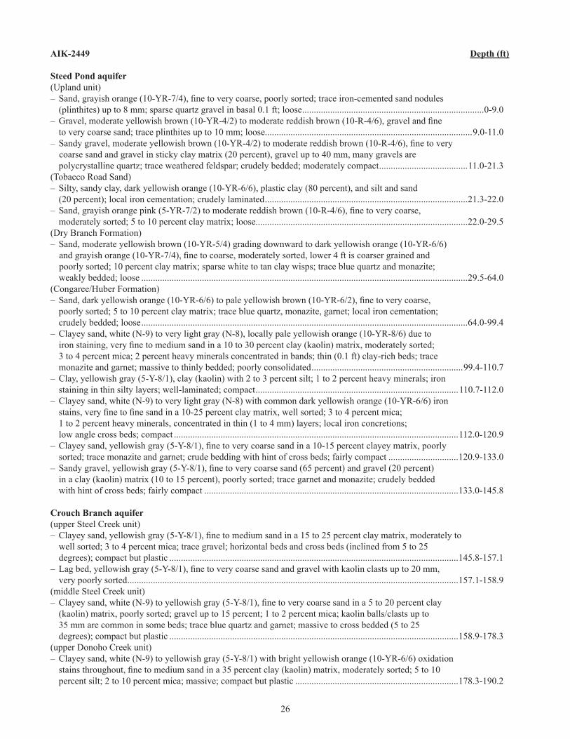
26
AIK-2449 Depth (ft)
Steed Pond aquifer(Upland unit)– Sand, grayish orange (10-YR-7/4), fine to very coarse, poorly sorted; trace iron-cemented sand nodules (plinthites) up to 8 mm; sparse quartz gravel in basal 0.� ft; loose ..............................................................................0-9.0– Gravel, moderate yellowish brown (10-YR-4/2) to moderate reddish brown (10-R-4/6), gravel and fine to very coarse sand; trace plinthites up to �0 mm; loose.........................................................................................9.0-��.0– Sandy gravel, moderate yellowish brown (10-YR-4/2) to moderate reddish brown (10-R-4/6), fine to very
coarse sand and gravel in sticky clay matrix (20 percent), gravel up to 40 mm, many gravels are polycrystalline quartz; trace weathered feldspar; crudely bedded; moderately compact ......................................��.0-2�.3(Tobacco Road Sand)– Silty, sandy clay, dark yellowish orange (�0-YR-6/6), plastic clay (80 percent), and silt and sand (20 percent); local iron cementation; crudely laminated .......................................................................................2�.3-22.0– Sand, grayish orange pink (5-YR-7/2) to moderate reddish brown (10-R-4/6), fine to very coarse, moderately sorted; 5 to �0 percent clay matrix; loose...........................................................................................22.0-29.5(Dry Branch Formation)– Sand, moderate yellowish brown (�0-YR-5/4) grading downward to dark yellowish orange (�0-YR-6/6)
and grayish orange (10-YR-7/4), fine to coarse, moderately sorted, lower 4 ft is coarser grained and poorly sorted; �0 percent clay matrix; sparse white to tan clay wisps; trace blue quartz and monazite;
weakly bedded; loose ............................................................................................................................................29.5-64.0 (Congaree/Huber Formation)– Sand, dark yellowish orange (10-YR-6/6) to pale yellowish brown (10-YR-6/2), fine to very coarse,
poorly sorted; 5 to �0 percent clay matrix; trace blue quartz, monazite, garnet; local iron cementation; crudely bedded; loose ............................................................................................................................................64.0-99.4– Clayey sand, white (N-9) to very light gray (N-8), locally pale yellowish orange (�0-YR-8/6) due to iron staining, very fine to medium sand in a 10 to 30 percent clay (kaolin) matrix, moderately sorted; 3 to 4 percent mica; 2 percent heavy minerals concentrated in bands; thin (0.� ft) clay-rich beds; trace monazite and garnet; massive to thinly bedded; poorly consolidated .................................................................99.4-��0.7– Clay, yellowish gray (5-Y-8/�), clay (kaolin) with 2 to 3 percent silt; � to 2 percent heavy minerals; iron staining in thin silty layers; well-laminated; compact .......................................................................................��0.7-��2.0– Clayey sand, white (N-9) to very light gray (N-8) with common dark yellowish orange (�0-YR-6/6) iron
stains, very fine to fine sand in a 10-25 percent clay matrix, well sorted; 3 to 4 percent mica; � to 2 percent heavy minerals, concentrated in thin (� to 4 mm) layers; local iron concretions; low angle cross beds; compact ..........................................................................................................................��2.0-�20.9– Clayey sand, yellowish gray (5-Y-8/1), fine to very coarse sand in a 10-15 percent clayey matrix, poorly sorted; trace monazite and garnet; crude bedding with hint of cross beds; fairly compact ..............................�20.9-�33.0– Sandy gravel, yellowish gray (5-Y-8/1), fine to very coarse sand (65 percent) and gravel (20 percent) in a clay (kaolin) matrix (�0 to �5 percent), poorly sorted; trace garnet and monazite; crudely bedded with hint of cross beds; fairly compact .............................................................................................................�33.0-�45.8
Crouch Branch aquifer(upper Steel Creek unit)– Clayey sand, yellowish gray (5-Y-8/1), fine to medium sand in a 15 to 25 percent clay matrix, moderately to
well sorted; 3 to 4 percent mica; trace gravel; horizontal beds and cross beds (inclined from 5 to 25 degrees); compact but plastic ............................................................................................................................�45.8-�57.�– Lag bed, yellowish gray (5-Y-8/1), fine to very coarse sand and gravel with kaolin clasts up to 20 mm, very poorly sorted ..............................................................................................................................................�57.�-�58.9(middle Steel Creek unit)– Clayey sand, white (N-9) to yellowish gray (5-Y-8/1), fine to very coarse sand in a 5 to 20 percent clay
(kaolin) matrix, poorly sorted; gravel up to �5 percent; � to 2 percent mica; kaolin balls/clasts up to 35 mm are common in some beds; trace blue quartz and garnet; massive to cross bedded (5 to 25 degrees); compact but plastic ............................................................................................................................�58.9-�78.3(upper Donoho Creek unit)– Clayey sand, white (N-9) to yellowish gray (5-Y-8/�) with bright yellowish orange (�0-YR-6/6) oxidation
stains throughout, fine to medium sand in a 35 percent clay (kaolin) matrix, moderately sorted; 5 to 10 percent silt; 2 to �0 percent mica; massive; compact but plastic ......................................................................�78.3-�90.2
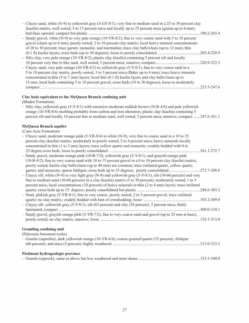
27
– Clayey sand, white (N-9) to yellowish gray (5-GY-8/1), very fine to medium sand in a 25 to 30 percent clay (kaolin) matrix, well sorted; 5 to �5 percent mica and locally up to 25 percent mica (grains up to 4 mm);
bed fines upward; compact but plastic ..............................................................................................................�90.2-203.4– Sandy gravel, white (N-9) to very pale orange (10-YR-8/2), fine to very coarse sand with 5 to 10 percent
gravel (clasts up to 6 mm), poorly sorted; 2 to �0 percent clay matrix; local heavy-mineral concentrations of 20 to 30 percent; trace garnet, monazite, and tourmaline; trace clay balls/clasts (up to �2 mm); thin (0.� ft) kaolin layers; cross beds (up to 30 degrees); loose to poorly consolidated ..........................................203.4-220.9– Silty clay, very pale orange (�0-YR-8/2), plastic clay (kaolin) containing 5 percent silt and locally 10 percent very fine to fine sand, well sorted; 5 percent mica; massive; compact ............................................220.9-223.5– Clayey sand, very pale orange (10-YR-8/2) to yellowish gray (5-Y-8/1), fine to very coarse sand in a 5 to 10 percent clay matrix, poorly sorted; 3 to 5 percent mica (flakes up to 4 mm); trace heavy minerals concentrated in thin (5 to 7 mm) layers; local thin (0.� ft) kaolin layers and clay balls/clasts up to �5 mm; local beds containing 5 to �0 percent gravel; cross beds (�0 to 30 degrees); loose to moderately compact .............................................................................................................................................................223.5-247.6
Clay beds equivalent to the McQueen Branch confining unit(Bladen Formation)– Silty clay, yellowish gray (5-Y-8/�) with extensive moderate reddish brown (�0-R-4/6) and pale yellowish
orange (�0-YR-8/6) mottling probably from carbon and iron alteration, plastic clay (kaolin) containing 5 percent silt and locally 10 percent fine to medium sand, well sorted; 5 percent mica; massive; compact .......247.6-26�.�
McQueen Branch aquifer(Cane Acre Formation)– Clayey sand, moderate orange pink (5-YR-8/4) to white (N-9), very fine to coarse sand in a 10 to 25 percent clay (kaolin) matrix, moderately to poorly sorted; 2 to 4 percent mica; heavy minerals locally
concentrated in thin (� to 2 mm) layers; trace yellow quartz and monazite; crudely bedded with 0 to 25 degree cross beds; loose to poorly consolidated .........................................................................................26�.�-272.7– Sandy gravel, moderate orange pink (�0-R-7/4), yellowish gray (5-Y-8/�), and grayish orange pink (10-R-8/2), fine to very coarse sand with 10 to 15 percent gravel in a 0 to 10 percent clay (kaolin) matrix,
poorly sorted; kaolin clay balls/clasts (up to 40 mm) are common; trace rutilated quartz, yellow quartz, garnet, and monazite; sparse feldspar; cross beds up to 35 degrees; poorly consolidated ...............................272.7-288.6– Clayey silt, white (N-9) to very light gray (N-8) and yellowish gray (5-Y-8/�), silt (�0-60 percent) and very
fine to medium sand (10-60 percent) in a clay (kaolin) matrix (5 to 30 percent), moderately sorted; 1 to 3 percent mica; local concentrations (�0 percent) of heavy minerals in thin (2 to 4 mm) layers; trace rutilated
quartz; cross beds up to �5 degrees; poorly consolidated but plastic ..............................................................288.6-303.2– Sand, pinkish gray (5-YR-8/1), fine to very coarse, poorly sorted; 2 to 3 percent gravel; trace rutilated quartz; no clay matrix; crudely bedded with hint of crossbedding; loose ........................................................303.2-309.0– Clayey silt, yellowish gray (5-Y-8/�), silt (65 percent) and clay (30 percent); 5 percent mica; thinly laminated; compact ...........................................................................................................................................309.0-3�0.�– Sandy gravel, grayish orange pink (5-YR-7/2), fine to very coarse sand and gravel (up to 25 mm at base), poorly sorted; no clay matrix; massive; loose ..................................................................................................3�0.�-3�3.0
Gramling confining unit(Paleozoic basement rocks)– Granite (saprolite), dark yellowish orange (�0-YR-6/6), coarse-grained quartz (35 percent), feldspar (60 percent), and mica (5 percent); highly weathered ......................................................................................3�3.0-333.5
Piedmont hydrogeologic province– Granite (saprock), same as above but less weathered and more dense .............................................................333.5-340.0

28
AIK-2449Missing intervals (ft)
0.0–8.3�4.4–�5.024.0–30.036.5–40.045.0–50.054.0–60.063.9–66.068.7–70.072.7–75.077.2–80.082.4–98.7
�06.3–��0.0��7.5–�20.0�26.7–�30.0�39.2–�40.0�49.3–�50.0�58.9–�60.0�69.3–�70.0�89.�–�90.0�98.5–200.0209.7–2�0.02�9.8–220.0227.2–230.0267.7–268.0279.6–280.0288.9–290.0298.6–299.0309.4–3�0.03�8.9–320.0327.0–330.0339.5–340.0

PE
RIO
D
SE
RIE
S
SU
BS
ER
IES
EU
RO
PE
AN
STA
GE
ALL
OS
TRAT
IGR
AP
HIC
FO
RM
ATIO
N
CA
LCA
RE
OU
S N
AN
NO
FOS
SIL
ZO
NE
HY
DR
OS
TRAT
IGR
AP
HIC
SY
STE
M
HY
DR
OS
TRAT
IGR
AP
HIC
UN
IT
HY
DR
OS
TRAT
IGR
AP
HIC
ZO
NE
ELE
VATI
ON
(FE
ET)
DE
PTH
(FE
ET)
PE
RIO
D
SE
RIE
S
SU
BS
ER
IES
EU
RO
PE
AN
STA
GE
ALL
OS
TRAT
IGR
AP
HIC
FO
RM
ATIO
N
CA
LCA
RE
OU
S N
AN
NO
FOS
SIL
ZO
NE
HY
DR
OS
TRAT
IGR
AP
HIC
SY
STE
M
HY
DR
OS
TRAT
IGR
AP
HIC
UN
IT
HY
DR
OS
TRAT
IGR
AP
HIC
ZO
NE
ELE
VATI
ON
(FE
ET)
DE
PTH
(FE
ET)
CO
RE
RE
CO
VE
RY
LITH
OLO
GY
SPONTANEOUS-POTENTIAL(mvol)
GAMMA-RAY(cps)
SHORT NORMAL(ohm-m)
LONG NORMAL(ohm-m)
SPONTANEOUS-POTENTIAL(mvol)
GAMMA-RAY(cps)
SHORT NORMAL(ohm-m)
SINGLE-POINT(ohms)
LONG NORMAL(ohm-m)
South Carolina Department of Natural ResourcesLand, Water and Conservation DivisionWater Resources Report 43Plate 1: Stratigraphy, geophysical logs, and lithology of core holes AIK-2448 and AIK-2449
Well: AIK-2448 Latitude: 33° 37′ 28″ NLongitude: 81° 50′ 59″ WElevation: 490 feetGeology and core description by Dr. David C. Prowell (USGS)
Well: AIK-2449 Latitude: 33° 32′ 22″ NLongitude: 81° 51′ 18″ WElevation: 494 feetGeology and core description by Dr. David C. Prowell (USGS)
LITHOLOGY
LITHOLOGY
Clayeysand
Sand andgravelSand Granite Gneiss/schistUnconformity
lag
Clayeysand ClaySand and
gravelSand
GraniteClayey silt
Silty clayGravel
Unconformitylag
CRETA-CEOUS Upper
Upper
Middle
LowerTER
TIA
RY
CR
ETA
CE
OU
STE
RTI
AR
Y
Eoc
ene
Eoc
ene
Upp
er
Cam
pani
an uppe
rD
onoh
oC
reek
Maastrich-tian
PR
E-
TRIA
SS
IC
Priabonian
Ypresian
Granite Gramlingconfining
unit
Appletonconfiningsystem
Granite Granite/Gneiss
Gneiss
UTRzone
Gordonzone
UpperThreeRunszone
Gordonzone
Tobacco Rd
Cam-panian
Lutetian
Con
-ga
ree
upperDonohoCreek
DryBranch
NP
12-
14
NP19-20
NP19-20
CC-23
NP
12-1
4C
C-2
3
CC-26aCC-25b
CC-21
CC-19
CrouchBranch
Cro
uch
Bra
nch
WAT
ER
LE
VE
L +
406.
3 FT
MS
L (5
/18/
1999
)
CO
RE
RE
CO
VE
RY
LITH
OLO
GY
WAT
ER
LE
VE
L +
238.
3 FT
MS
L (5
/18/
1999
)
NN2-3
FLO
RID
AN
-MID
VIL
LEA
QU
IFE
R S
YS
TEM
FLO
RID
AN
-MID
VIL
LEA
QU
IFE
R S
YS
TEM
Ste
ed P
ond
Ste
ed P
ond
screen
screen
Miocene Lower Upland
Con
gare
e
DryBranch
Tob. Rd.
u. Steel Crk.
Bladen
CaneAcre
McQueen Br.confining unit
Gramlingconfining
unit
Appletonconfiningsystem
McQ
ueen
Br.
aqui
fer
middleSteel Creek
Pria-bonian
Burdi-galian
Upper
Low
er -
Mid
dle
Ypre
sian
- Lu
tetia
n
PRE-TRIASSIC
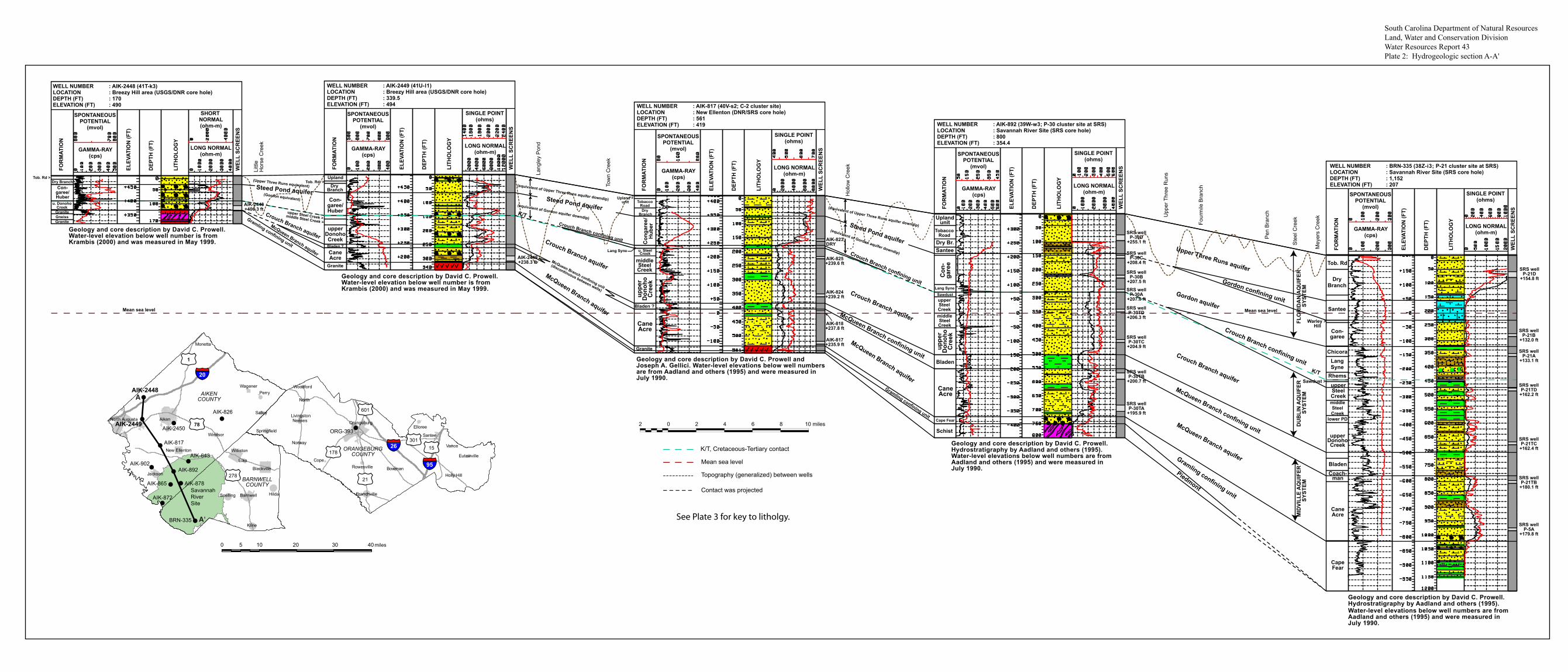
WELL NUMBER : AIK-2448 (41T-k3)LOCATION : Breezy Hill area (USGS/DNR core hole)DEPTH (FT) : 170ELEVATION (FT) : 490 WELL NUMBER : AIK-817 (40V-s2; C-2 cluster site)
LOCATION : New Ellenton (DNR/SRS core hole)DEPTH (FT) : 561ELEVATION (FT) : 419 WELL NUMBER : AIK-892 (39W-w3; P-30 cluster site at SRS)
LOCATION : Savannah River Site (SRS core hole)DEPTH (FT) : 800ELEVATION (FT) : 354.4
SPONTANEOUSPOTENTIAL
(mvol)
GAMMA-RAY(cps)
SPONTANEOUSPOTENTIAL
(mvol)
GAMMA-RAY(cps)
SPONTANEOUSPOTENTIAL
(mvol)
GAMMA-RAY(cps)
SPONTANEOUSPOTENTIAL
(mvol)
GAMMA-RAY(cps)
LONG NORMAL(ohm-m)
LONG NORMAL(ohm-m)
SHORT NORMAL(ohm-m)
FOR
MAT
ION
ELEV
ATIO
N (F
T)
DEP
TH (F
T)
WEL
L SC
REE
NS
LITH
OLO
GY
FOR
MAT
ION
ELEV
ATIO
N (F
T)
DEP
TH (F
T)
WEL
L SC
REE
NS
LITH
OLO
GY
FOR
MAT
ION
ELEV
ATIO
N (F
T)
DEP
TH (F
T)
WEL
L SC
REE
NS
LITH
OLO
GY
FOR
MAT
ION
ELEV
ATIO
N (F
T)
DEP
TH (F
T)
WEL
L SC
REE
NS
LITH
OLO
GY
FOR
MAT
ION
ELEV
ATIO
N (F
T)
DEP
TH (F
T)
WEL
L SC
REE
NS
LITH
OLO
GY
Tob. Rd >
Granite
Granite
Granite
GraniteGneiss
Dry BranchCon-
garee/Huber Con-
garee/Huber
Con
gare
e/H
uber
Con
-ga
ree
CaneAcre
CaneAcre
Dry Branch
Dry Branch
u. SteelCreek
middleSteelCreek
Upland >unit
Uplandunit
Lang Syne
Tob. Rd. >
TobaccoRoad
TobaccoRoad
Lang Syne
upperSteelCreekmiddleSteelCreek
Sawdust
Dry Br.Santee
Bladen ?
Bladen ?
upper Steel Creek >middle Steel Creek >
Upland
u. DonohoCreek
upperDonohoCreek
uppe
rD
onoh
oC
reek
CaneAcre
Cape Fear
Schist
Bladen
uppe
rD
onoh
oC
reek
SINGLE POINT(ohms)
LONG NORMAL(ohm-m)
SINGLE POINT(ohms)
LONG NORMAL(ohm-m)
SINGLE POINT(ohms)
SPONTANEOUSPOTENTIAL
(mvol)
GAMMA-RAY(cps)
LONG NORMAL(ohm-m)
SINGLE POINT(ohms)
McQueen Branch aquifer
McQueen Branch aquifer
McQueen Branch confining unit
(discontinuous between wells)
McQueen Branch confining unit
Crouch Branch confining unit
Crouch Branch confining unit
Crouch Branch aquiferCrouch Branch aquifer
McQueen Branch aquifer
Crouch Branch aquifer
Steed Pond aquifer (Gordon equivalent)
(Upper Three Runs equivalent)
Steed Pond aquifer
Steed Pond aquiferUpper Three Runs aquifer
Gordon aquifer
Gordon confining unit
(equivalent of Gordon aquifer downdip)
(equivalent of Upper Three Runs aquifer downdip)
Gramling confining unit
Gramling confining unit
McQueen Branch confining unit
Crouch Branch confining unit
McQueen Branch aquifer
Crouch Branch aquifer
Gramling confining unit
Piedmont
AIK-2449+238.3 ft
AIK-2448+406.3 ft
(equivalent of Gordon aquifer downdip)
(equivalent of Upper Three Runs aquifer downdip)
K/T
Mean sea level
WELL NUMBER : BRN-335 (38Z-i3; P-21 cluster site at SRS)LOCATION : Savannah River Site (SRS core hole)DEPTH (FT) : 1,152ELEVATION (FT) : 207
Tob. Rd
DryBranch
Santee
Con-garee
Chicora
Rhems
LangSyne
Sawdust >
Warley > Hill
lower PD
upperSteelCreekmiddleSteelCreek
upperDonohoCreek
Bladen
CapeFear
CaneAcre
Coach-man
K/T
Mean sea level
SRS wellP-21D
+154.8 ft
AIK-817+235.9 ft
AIK-818+237.8 ft
AIK-824+239.2 ft
AIK-825+239.6 ft
SRS wellP-30D
+255.1 ft
SRS wellP-30C
+208.4 ft
SRS wellP-30B
+207.5 ft
SRS wellP-30A
+207.0 ft
SRS wellP-30TD
+206.3 ft
SRS wellP-30TC
+204.9 ft
SRS wellP-30TB
+200.7 ft
SRS wellP-30TA
+195.9 ft
AIK-823DRY
SRS wellP-21B
+132.0 ft
SRS wellP-21A
+133.1 ft
SRS wellP-21TD
+162.2 ft
SRS wellP-21TC
+162.4 ft
SRS wellP-21TB
+180.1 ft
SRS wellP-5A
+179.8 ft
Geology and core description by David C. Prowell.Hydrostratigraphy by Aadland and others (1995).Water-level elevations below well numbers are from Aadland and others (1995) and were measured inJuly 1990.
Geology and core description by David C. Prowell.
Geology and core description by David C. Prowell andJoseph A. Gellici. Water-level elevations below well numbersare from Aadland and others (1995) and were measured inJuly 1990.
Geology and core description by David C. Prowell.Water-level elevation below well number is from Krambis (2000) and was measured in May 1999.
Geology and core description by David C. Prowell.Water-level elevation below well number is fromKrambis (2000) and was measured in May 1999.
Hydrostratigraphy by Aadland and others (1995).Water-level elevations below well numbers are from Aadland and others (1995) and were measured inJuly 1990.
0 2 4 6 8 10 miles2
Mean sea level
Topography (generalized) between wells
Contact was projected
Littl
eH
orse
Cre
ek
Lang
ley
Pon
d
Tow
n C
reek
Hol
low
Cre
ek
Four
mile
Bra
nch
Pen
Bra
nch
Ste
el C
reek
Mey
ers
Cre
ek
Upp
er T
hree
Run
s
K/T, Cretaceous-Tertiary contact
DU
BLI
N A
QU
IFER
SYS
TEM
FLO
RID
AN
AQ
UIF
ER S
YSTE
MM
IDVI
LLE
AQ
UIF
ER S
YSTE
M
South Carolina Department of Natural ResourcesLand, Water and Conservation DivisionWater Resources Report 43 Plate 2: Hydrogeologic section A-A'
WELL NUMBER : AIK-2449 (41U-l1)LOCATION : Breezy Hill area (USGS/DNR core hole)DEPTH (FT) : 339.5ELEVATION (FT) : 494
See Plate 3 for key to litholgy.
!
!
!!
!
!
!
!
!
!
!
!
!
§̈¦26
§̈¦95
Aiken
Jackson
New Ellenton
North Augusta
Perry
Salley
Wagener
Windsor
Monetta
Orangeburg
Branchville
Santee
Neeses
North
Holly Hill
SpringfieldElloree
Bowman
Norway
Eutawville
Woodford
Vance
Livingston
RowesvilleCope
£¤78
£¤1
£¤278
£¤178
£¤301
£¤21
£¤15
£¤601
miles
AIK-826
AIK-2448
AIK-2449AIK-2450
AIK-817
AIK-643
BRN-335
ORG-393
AIK-892
AIK-878
AIK-872
AIK-865
AIK-902
Barnwell
Williston
Elko
Hilda
Kline
Blackville
Snelling
§̈¦20
SavannahRiverSite
ORANGEBURGCOUNTY
AIKENCOUNTY
BARNWELLCOUNTY
0 5 10 20 30 40
A'
A

SPONTANEOUSPOTENTIAL
(mvol)
GAMMA-RAY(cps)
LONG NORMAL(ohm-m)
FOR
MAT
ION
ELEV
ATIO
N (F
T)
DEP
TH (F
T)
WEL
L SC
REE
NS
LITH
OLO
GY
SINGLE POINT(ohms)
WELL NUMBER : AIK-2449 (41U-l1)LOCATION : Breezy Hill area (USGS/DNR core hole)DEPTH (FT) : 339.5ELEVATION (FT) : 494
McQueen Branch aquifer
Crouch Branch aquifer
Steed Pond aquifer (Gordon equivalent)
(Upper Three Runs equivalent)
Gramling confining unit
McQueen Branch confining unit(discontinuous between wells)
SPONTANEOUSPOTENTIAL
(mvol)
GAMMA-RAY(cps)
LONG NORMAL(ohm-m)
ELEV
ATIO
N (F
T)
DEP
TH (F
T)
WEL
L SC
REE
NS
LITH
OLO
GY
SINGLE POINT(ohms)
WELL NUMBER : AIK-2450 (39U-r6)LOCATION : Aiken (city well)DEPTH (FT) : 473ELEVATION (FT) : 490
(Gordon equivalent)
(Upper Three Runs equivalent)
McQueen Branch aquifer
Crouch Branch aquifer
Crouch Branch confining unit(probably discontinuous between wells)
Steed Pond aquifer
Steed Pond aquifer
McQueen Branch confining unit
Screens in AIK-2450.
Screens in AIK-2450.
AIK-2449+238.3 ft
Geology and core description by David C. Prowell.Water-level elevation below well number is fromKrambis (2000) and was measured in May 1999.
Lithology was estimated from driller’s log and geophysical logs. This well pumps approx. 1,000 gpm and has a specific capacity of 24 gpm/ft. A static water level of +339 ft was measured after the well was completed in December 1998.
(probably discontinuous between wells)
SPONTANEOUSPOTENTIAL
(mvol)
GAMMA-RAY(cps)
LONG NORMAL(ohm-m)
WEL
L SC
REE
NS
SHORT NORMAL(ohm-m)
FOR
MAT
ION
ELEV
ATIO
N (F
T)
DEP
TH (F
T)
LITH
OLO
GY
WELL NUMBER : AIK-826 (36U-o1; C-3 cluster site)LOCATION : Aiken State Park (DNR/SRS core hole)DEPTH (FT) : 540ELEVATION (FT) : 295
Geology and core description by Joseph A. Gellici. Water-level elevations below well numbers are from Aadlandand others (1995) and were measured in July 1990.
Con-garee/HuberLangSyneSteelCreekundif.
upperDonohoCreek
Bladen
CaneAcre
Schist
AIK-845+274.0 ft
AIK-826+274.4 ft
AIK-846+274.3 ft
AIK-847+274.3 ft
AIK-848+267.0 ft
AIK-849+259.5 ft
WELL NUMBER : ORG-393 (29U-v1)LOCATION : Orangeburg (USGS/DNR core hole)DEPTH (FT) : 1,138ELEVATION (FT) : 253
SPONTANEOUSPOTENTIAL
(mvol)
GAMMA-RAY(cps)
LONG NORMAL(ohm-m)
FOR
MAT
ION
WEL
L SC
REE
NS
ELEV
ATIO
N (F
T)
DEP
TH (F
T)
LITH
OLO
GY
SINGLE POINT(ohms)
unnamedunnamed
Santee
Con-garee
Rhems
lower PD
Sawdust
upperSteelCreekmiddle
Steel Crk
upperDonohoCreek
middleDonoho
Bladen
CapeFear
Redbeds
CaneAcre
Coach-man
Warley Hill >
ORG-431+223.3 ft
ORG-430+167.9 ft
ORG-393+143.7 ft
Crouch Branch aquifer
Gordon confining unitGordon aquiferCrouch Branch confining unit
McQueen Branch confining unit
Upper Three Runs aquifer
McQueen Branch aquifer
Gramling confining unit
Surficial aquifer zone
DU
BLI
N A
QU
IFER
SYS
TEM
FLO
RID
AN
AQ
UIF
ER S
YSTE
MM
IDVI
LLE
AQ
UIF
ER S
YSTE
M
0 2 4 6 8 10 miles2
Geology and core description by David C. Prowell.Water-level elevations below well numbers weremeasured on July 7, 2006.
K/T
Mean sea levelMean sea level
FLO
RID
AN
-MID
VILL
E A
QU
IFER
SYS
TEM
Mean sea level
Topography (generalized) between wells
K/T, Cretaceous-Tertiary contact
South Carolina Department of Natural ResourcesLand, Water and Conservation DivisionWater Resources Report 43 Plate 3: Hydrogeologic section B-B'
Granite
Con-garee/Huber
CaneAcre
Dry Branch
Tob. Rd. >
Bladen ?
upper Steel Creek >middle Steel Creek >
Upland
upperDonohoCreek
Lang
ley
Pon
d
Cha
vous
Cre
ek
Sou
th F
ork
Edi
sto
Riv
er
Goo
dlan
d C
reek
Tam
pa C
reek
Roc
ky S
wam
p C
reek
Bol
en M
ill C
reek
Nor
th F
ork
Edi
sto
Riv
er
Sw
amp
Cre
ek
!
!
!!
!
!
!
!
!
!
!
!
!
§̈¦26
§̈¦95
Aiken
Jackson
New Ellenton
North Augusta
Perry
Salley
Wagener
Windsor
Monetta
Orangeburg
Branchville
Santee
Neeses
North
Holly Hill
SpringfieldElloree
Bowman
Norway
Eutawville
Woodford
Vance
Livingston
RowesvilleCope
£¤78
£¤1
£¤278
£¤178
£¤301
£¤21
£¤15
£¤601
miles
AIK-826
AIK-2448
AIK-2449
AIK-2450
AIK-817
AIK-643
BRN-335
ORG-393
AIK-892
AIK-878
AIK-872
AIK-865
AIK-902
Barnwell
Williston
Elko
Hilda
Kline
Blackville
Snelling
§̈¦20
SavannahRiverSite
ORANGEBURGCOUNTY
AIKENCOUNTY
BARNWELLCOUNTY
0 5 10 20 30 40
BB'
Crossbed-ded sand
Sandstone
Clayey sandand gravel
Silty clay
Schist Gneiss/schist
Sand
Calcareousclayey sand
Phosphaticcalcarenite
Calcarenite
Gravel
Marl Phosphaticmarl
Shellylimestone
Sandymarl
Limestone
Fossilbed
Sandylimestone
Unconform-ity lag
Silt
Dolomite
Micrite
Biomicrite
Redbeds
Basalt
Granite Slate/phyllite
Sandyclay
Clayeysilt
Silty sand Sand andgravel
Calcareoussand
Clayey sand
Glauconiticsand
Phosphaticsand
Laminatedsand/silt
Interbeddedsand/clay
Clay Calcareoussandy clay
Lithology Key