Embed Size (px)
Citation preview

\\fuji\anchor\Projects\Lincoln County\SMP 2013\Deliverables\Restoration Plan\Lincoln County FinalDraft Restoration Plan_032016.docx
FINAL DRAFT RESTORATION PLAN LINCOLN COUNTY COALITION SHORELINE MASTER PROGRAM
Prepared for Lincoln County Coalition
Prepared by Anchor QEA, LLC
8033 W. Grandridge Boulevard, Suite A
Kennewick, Washington 99336
This report was funded through a grant from the Washington State Department of Ecology
October 2015
Final Draft Restoration Plan October 2015 Lincoln County Coalition SMP Update i 131032-01.01
TABLE OF CONTENTS 1 INTRODUCTION ................................................................................................................ 1
1.1 Purpose and Scope of Plan ...............................................................................................1
1.2 Key Elements of Restoration Planning in Shoreline Master Program Process ............3
2 BACKGROUND ................................................................................................................... 5
2.1 Planning Area Characteristics .........................................................................................5
2.1.1 Lincoln County Existing Land Use ............................................................................6
2.1.2 Town of Odessa Existing Land Use ...........................................................................7
2.1.3 Town of Reardan Existing Land Use .........................................................................8
2.2 Geology .............................................................................................................................8
2.3 Water Resources ...............................................................................................................9
2.4 Climate and Precipitation ................................................................................................9
3 EXISTING RESTORATION PLANNING, PROGRAMS, AND PARTNERS ..................... 12
3.1 Lincoln Conservation District .......................................................................................12
3.2 Spokane Tribe and Colville Confederated Tribes .........................................................13
3.3 Washington State Recreation and Conservation Office ..............................................13
3.4 Nonprofit Groups ...........................................................................................................13
3.5 U.S. Bureau of Land Management .................................................................................14
3.6 U.S. Bureau of Reclamation ...........................................................................................15
3.7 National Park Service .....................................................................................................15
3.8 U.S. Department of Agriculture ....................................................................................15
3.9 U.S. Fish and Wildlife Service .......................................................................................16
3.10 Washington State ...........................................................................................................16
3.11 Washington State Conservation Commission ..............................................................16
3.12 Washington State Department of Ecology ...................................................................16
3.13 Washington State Department of Fish and Wildlife ....................................................17
3.14 Washington State Department of Natural Resources ..................................................17
4 RESTORATION CONTEXT, GOALS, AND PRIORITIES ................................................ 18
4.1 Shoreline Impairments...................................................................................................18
4.2 Restoration Goals and Objectives ..................................................................................28
4.3 Restoration Opportunities .............................................................................................28
Table of Contents
Final Draft Restoration Plan October 2015 Lincoln County Coalition SMP Update ii 131032-01.01
4.3.1 General Restoration Opportunities .........................................................................29
4.3.2 Site-specific Restoration and Protection Opportunities ........................................29
4.4 Project Evaluation and Prioritization Criteria .............................................................33
5 IMPLEMENTATION, MONITORING, AND REVIEW .................................................... 34
5.1 Potential Restoration Funding Partners .......................................................................34
5.2 Timelines, Benchmarks, and Monitoring .....................................................................36
5.3 Shoreline Master Program Review ...............................................................................37
6 REFERENCES .................................................................................................................... 38
List of Tables Table 1 Area of Land Use Types within Lincoln County ................................................. 6
Table 2 Ecological Processes and Structures Affected by Major Alterations ................. 19
Table 3 Site-specific Restoration and Protection Opportunities in the Lincoln County Coalition Area ...................................................................................................... 30

Final Draft Restoration Plan October 2015 Lincoln County Coalition SMP Update iii 131032-01.01
LIST OF ACRONYMS AND ABBREVIATIONS ALEA Aquatic Lands Enhancement Account
BLM Bureau of Land Management
Coalition Lincoln County Coalition
CRP Community-based Restoration Program
District Lincoln Conservation District
Ecology Washington State Department of Ecology
F Fahrenheit
IAC Shoreline Inventory, Analysis, and Characterization
NOAA National Oceanographic and Atmospheric Administration
NPS National Park Service
OHWM Ordinary High Water Mark
Plan Restoration Plan
PDO Pacific Decadal Oscillation
RCO Washington State Recreation and Conservation Office
RCW Revised Code of Washington
Reclamation U.S. Bureau of Reclamation
RMP Resource Management Plan
SMA Shoreline Management Act
SMP Shoreline Master Program
SR subreach
TNC The Nature Conservancy
USFWS U.S. Fish and Wildlife Service
WAC Washington Administrative Code
WDFW Washington Department of Fish and Wildlife
WDNR Washington State Department of Natural Resources
Final Draft Restoration Plan October 2015 Lincoln County Coalition SMP Update 1 131032-01.01
1 INTRODUCTION
Lincoln County, the Town of Odessa, and the Town of Reardan have formed the Lincoln County Coalition (Coalition) to develop a regional Shoreline Master Program (SMP). Lincoln County adopted its original SMP in 1975. The towns of Odessa and Reardan do not have prior SMPs. The Washington State Department of Ecology (Ecology) adopted the 2003 Shoreline Management Act (SMA) guidelines (Chapter 173-26 Washington Administrative Code [WAC] Guidelines), which require local government review and updates of SMPs. The updated version of the Coalition SMP provides goals, policies, and regulations for the Coalition shorelines. This Restoration Plan (Plan) has been prepared in support of the Coalition’s SMP. The SMP is being prepared to comply with the Washington State SMA requirements (Revised Code of Washington [RCW] 90.58) and the state’s SMP guidelines (WAC 173-26, Part III-201 2(f)), which were adopted in 2003. The SMP establishes policies and regulations that regulate the use and development of the river, stream, and lake shorelines, as well as the restoration actions contained within this Plan. The areas covered by this Plan includes the river, stream, and lake shorelines under SMP jurisdiction within the County and the two towns. The scope of this document, the definition of restoration, and the key elements in restoration planning in the SMP process are discussed next.
1.1 Purpose and Scope of Plan
The purpose of this Plan is to describe how and where shoreline ecological functions can be restored within County SMP jurisdiction. The SMP guidelines (WAC 173-26-201(2)(f)) articulate that the Plan is to include specific elements, which are identified subsequently, along with the section in which the element occurs in this Plan:
1. Section 3 – An identification of existing and ongoing projects and programs currently being implemented that are designed to contribute to local restoration goals (such as capital improvement programs and watershed planning efforts).
2. Section 4 – An identification of degraded areas, impaired ecological functions, and sites with potential for ecological restoration.
Introduction
Final Draft Restoration Plan October 2015 Lincoln County Coalition SMP Update 2 131032-01.01
3. Section 4 – An establishment of overall goals and priorities for restoration of degraded areas and impaired ecological functions.
4. Sections 4 and 5 – An identification of additional projects and programs needed to achieve local restoration goals and implementation strategies, including identifying prospective funding sources for those projects and programs.
5. Section 5 – An identification of timelines and benchmarks for implementing restoration projects and programs and achieving local restoration goals.
6. Section 5 – Provisions for mechanisms or strategies to support restoration projects and programs implemented according to site-specific and other restoration plans and appropriately review the effectiveness of the projects and programs in meeting the overall restoration goals.
Although the Plan incorporates elements of other shoreline restoration planning documents that involve the shorelines under the County’s SMP jurisdiction, the scope of this Plan under the SMA guidance does not extend to that of a master document combining and aligning priorities of other shoreline restoration documents, plans, or efforts. It is expected alignment or conflict between this Plan and the goals of other plans (such as Comprehensive Plans) that occurs during implementation will be addressed within the context of the applicable regulations. This Plan does not provide or constitute any regulatory approval of the projects identified within the document. All applicable federal, state, and local regulatory requirements will need to be met, and all associated approvals will need to be obtained prior to implementation of any project. It is important to clarify that restoration, as it is discussed here, is distinct from the concept of protection of, or no net loss of, ecological function. The WAC defines “restoration” or “ecological restoration” as follows:
“…the reestablishment or upgrading of impaired ecological shoreline processes or functions. This may be accomplished through measures including, but not limited to, revegetation, removal of intrusive shoreline structures and removal or treatment of toxic materials. Restoration does not imply a requirement for returning the shoreline area to aboriginal or pre-European settlement conditions.”
Introduction
Final Draft Restoration Plan October 2015 Lincoln County Coalition SMP Update 3 131032-01.01
The state’s SMP policies include a standard that must be adhered to by new SMPs for no net loss of ecological functions that are necessary to sustain shoreline natural resources. Ecology has clarified that no net loss means, “establishing uses or conducting development are identified and mitigated with a final result that is no worse than maintaining the current level of environmental resource productivity” and “no uses or development supersede the requirement for environmental protection” (Ecology 2004). The current level of environmental productivity is the baseline level of function of the system. For the purposes of this Plan and the SMP, the environmental baseline is established as part of the Shoreline Inventory, Analysis, and Characterization (IAC) Report, or other reports prepared by the County referenced therein, as well as the other maps and data developed by the Coalition as part of the SMP update process. Thus, mitigation activities are the method by which no net loss is compensated, and the ecological information compiled and developed as part of the SMP update process is the baseline from which the no net loss is calculated. The distinction between no net loss and SMP restoration is that restoration goes beyond no net loss by establishing an increase in the amount, size, and/or functions of an ecosystem or components of an ecosystem compared to a baseline condition (Thom et al. 2005). Therefore, mitigation activities, including re-development and new development, which include mitigation activities, could not be considered as part of restoration under this Plan unless there was a beyond no net loss component to the work.
1.2 Key Elements of Restoration Planning in Shoreline Master Program Process
The state’s SMP guidelines require that the local SMP must give preference to certain shoreline uses in the following order: 1) reserve appropriate areas for protecting and restoring ecological functions to control pollution and prevent damage to the natural environment and public health; 2) reserve shoreline areas for water-dependent and associated water-related uses; 3) reserve shoreline areas for other water-related and water-enjoyment uses that are compatible with ecological protection and restoration objectives; 4) locate single-family residential uses where they are appropriate and can be developed without significant impact to ecological functions or displacement of water-dependent uses; and 5) limit non-water-oriented uses to those locations where the previously
Introduction
Final Draft Restoration Plan October 2015 Lincoln County Coalition SMP Update 4 131032-01.01
described uses are inappropriate or where non-water-oriented uses demonstrably contribute to the objectives of the SMA (WAC 173-26-201(2)(d)). The WAC guidelines also require SMPs to, “include goals, policies, and actions for restoration of impaired shoreline ecological functions” (WAC 173-26-186). The impaired functions are to be identified based on a detailed inventory and characterization of the shoreline ecosystem, and a restoration plan is to be formulated based on that information (WAC 137-26-201). The results of the inventory assessment were presented in the IAC Report for the County (Anchor QEA 2014). This Plan uses the information from the IAC Report to address the restoration plan requirements discussed in the SMP guidelines. This Plan is not a regulatory document or a set of regulatory requirements. However, the SMP points to this Plan as a guide outlining opportunities for improving shoreline ecological function within the jurisdiction of the Coalition.

Final Draft Restoration Plan October 2015 Lincoln County Coalition SMP Update 5 131032-01.01
2 BACKGROUND
Lincoln County is located in the eastern portion of Washington state and encompasses a total area of 2,339 square miles (6,059 square kilometers), of which 2,275 square miles (5,894 square kilometers) are land and 64 square miles (165 square kilometers; 2.7%) are water. The County is bordered by Okanogan, Ferry, and Stevens counties to the north, Spokane County to the east, Adams and Whitman counties to the south, and Grant County to the west. The Town of Odessa is located in the southwestern part of the County at the intersection of State Route 21 with State Route 28. The Town of Reardan is located in the northeastern portion of the County along Highway 2, approximately 30 miles west of Spokane.
2.1 Planning Area Characteristics
Private holdings make up the majority of the County. The U.S. Bureau of Land Management (BLM) owns the largest share of public lands at approximately 63,677 acres (4.25%). Another federal agency, the U.S. Bureau of Reclamation (Reclamation), owns about 20,458 acres (1.36%), most of which are aquatic lands managed by the National Park Service (NPS) in the Lake Roosevelt National Recreation Area. The rest of the public lands are owned by state agencies; Washington State Department of Natural Resources (WDNR) 44,339 acres (2.95%), Washington Department of Fish and Wildlife (WDFW) 18,156 acres (1.21%), and Washington State Department of Transportation 430 acres (0.03%). The Nature Conservancy (TNC), a non-governmental organization, owns about 343 acres (0.02%). Reclamation is the largest owner of the shoreline land in Lincoln County. This may seem disproportionally high due to the significant amount of Reclamation land located below the ordinary high water mark (OHWM) mark within the Lake Roosevelt National Recreation Area. Above OHWM, Reclamation accounts for approximately 25% of the County’s shoreline land ownership. Another federal agency, BLM, owns around 12% of shoreline lands near lakes such as Coffee Pot Lake in the central part of the County and Fishtrap Lake in the southeastern part of the County. State agencies (WDNR and WDFW) own about 7% of shoreline land, mostly adjacent to smaller lakes in the central and southeastern areas of the County. The rest of shoreline land (about 55%) is privately owned.
Background
Final Draft Restoration Plan October 2015 Lincoln County Coalition SMP Update 6 131032-01.01
2.1.1 Lincoln County Existing Land Use
Land cover type analysis indicates approximately 667,781 acres (43.5%) of Lincoln County, can be visually identified as agricultural or fallow lands. About 459,047 acres (29.9%), can be identified as shrub/scrubland. The rest of the County comprises a variety of other land covers. See Table 1 for summary of land cover types in the County. Although agriculture is a predominant land use in Lincoln County, much of the agricultural land is used for dryland crops due to the arid nature of the County. About 84% of the County's land use is assessed as agricultural land, though it may be fallow. The large area of agricultural land use may allow for more restoration opportunities given the lack of development.
Table 1 Area of Land Use Types within Lincoln County
Land Use Type Acreage Percentage of Total
Agricultural1 1,245,353.1 83.9%
Commercial 4,513.4 0.3%
Manufacturing 0.07 0.0%
Open Space 1,637.3 0.1%
Other (non-taxable) 88,346.2 6.0%
Parks/Recreation 571 0.1%
Residential 467.3 0.0%
Transportation 165.3 0.0%
Unknown 143,143.1 9.6%
Utilities 80.3 0.0%
Total 1,484,277.1 100%
Note: 1 = Includes shrub/scrubland
The zoning regulates different uses and development within the County. The County contains two major zones: Agricultural and Recreational. Agricultural constitutes about 95% and Recreational constitutes around 5% of the County's land. For the most part, recreational zoning coincides with the Lake Roosevelt National Recreational Area along the Columbia River shoreline.
Background
Final Draft Restoration Plan October 2015 Lincoln County Coalition SMP Update 7 131032-01.01
Apparent from the percentages identified for land use and zoning, the County's existing shoreline land use is dominated by Agricultural and non-taxable Public land. Other shoreline land uses include Residential, Open Space, Parks/Recreation, Commercial, and Rangeland. Non-taxable lands are owned by multiple state and federal agencies such as BLM, WDNR, and WDFW. Most of the shoreline along the Columbia River and westerly portion of the Spokane River are managed by the NPS as part of the Lake Roosevelt National Recreation Area. Zoning of this entire shoreline along the Columbia River is Recreational. Crab Creek and Lake Creek shorelines include public ownership of land by WDNR and WDFW.
2.1.2 Town of Odessa Existing Land Use
The shoreline within the Town of Odessa is highly modified, particularly on the west side. Existing land use along the shoreline is primarily residential with limited commercial land use. The east side of the shoreline is currently unimproved, and the zoning is residential on the south and industrial on the north shorelines. Odessa City Park is located along the shoreline. Odessa’s existing land use within the shoreline jurisdiction is approximately 5% residential, 5% open space, 0.3% commercial, 0.1% agricultural, 89% unknown, and 2% other use. The Town of Odessa does not have an existing SMP. Existing zoning includes Residential Zone I, Residential Zone II, Commercial, Industrial, and Public Use. The principal objective of Residential Zone I is to improve and maintain low-density residential development of single-family dwellings on individual lots. The principal objective of Residential Zone II is to improve and maintain a medium-density residential development of single-family dwellings, manufactured homes, duplexes, and townhouses. The principal objective of Commercial zoning is to group together businesses or business types necessary for the livelihood of the community but are generally incompatible with residential uses. Industrial uses are considered to be high-impact uses, and particular care is intended to be provided on possible impacts these uses can create on surrounding uses and areas. The Public Use zoning designation is not defined in the Town’s zoning code.
Background
Final Draft Restoration Plan October 2015 Lincoln County Coalition SMP Update 8 131032-01.01
2.1.3 Town of Reardan Existing Land Use
Most of the Town of Reardan shoreline is currently unimproved. The entire shoreline is within the mapped 100-year Federal Emergency Management Agency floodplain for Audubon Lake, with potential flooding risks from storms, such as rain or snow events, or sudden snow melts. Zoning of the northwest end of the shoreline has recently been changed from Industrial to Agricultural. Few residential structures are located west of State Route 231. The Town of Reardan does not have an existing SMP.
2.2 Geology
The geology of the County and its shorelines, including the various geological processes that affect the physical and biological functions of habitat was described in detail in the IAC Report for Lincoln County (Anchor QEA 2014). During the Missoula Floods that occurred more than 18,000 years ago, the Grand Coulee and the Crab Creek drainage areas were two of the major flow paths for the floodwaters and remain major hydrologic features. The wide, flat Quincy Basin, which is currently heavily developed for agriculture, is located at the outlet of these two constricted flowpaths, where the Missoula floodwaters spread out significantly and temporarily ponded, depositing large quantities of flood-carried sands and gravels (Easterbrook and Rahm 1970). Wind-driven fine material from these outburst flood deposits have more recently formed active sand dunes that are in some locations used for off-road vehicle recreation but are not well-suited for agriculture or other uses. Several smaller scale erosional features are present throughout the County, such as complexes of lakes that were once scour pools of flooding channels. Many of these have eroded to bedrock at the surface. Additional prominent geologic features present in the County include Palouse Formation loess (wind-blown silt) deposits atop high-relief areas that were not eroded in the floods. Loess-dominated areas are typically the source of excellent soils and dominated by agricultural uses, particularly wheat farming. Recent fluvial deposits (alluvium) deposited by post-glacial and modern-day streams are present in most of the major stream valleys. These deposits typically comprise sands and gravels.
Background
Final Draft Restoration Plan October 2015 Lincoln County Coalition SMP Update 9 131032-01.01
The unique topography of Lincoln County lends itself well to the development of modern drainage channels and reservoirs but may limit the available area suitable for restoration, with the exception of narrow vegetated bands along rivers, lake shores, and streams.
2.3 Water Resources
The IAC Report provides a significant inventory and characterization of water resources within the County, including resources that do not fall under the shoreline jurisdiction (Anchor QEA 2014). Lincoln County encompasses approximately 1.49 million acres, or approximately 2,339 square miles, in north-central Washington. Approximately 64 square miles (2.7%) of Lincoln County is water. A significant portion of this area is within Lake Roosevelt, the reservoir created by Grand Coulee Dam. Stream flow information and data is only sporadically available for the County. Given this, some basic observations were made. Based on the gauged flow data, stream flows in the County are highly variable and can generally be characterized as ephemeral. Annual flow cycles consist of seasonal high flows during the winter, followed by sharply decreasing flows starting in March or April, reaching minimum levels in early summer. The precipitation data indicate that in many years, the summer stream flows are supported by groundwater discharge. The water resources of Lincoln County are greatly influenced by the development of reservoirs, natural hydrological conditions, and water usage that have modified the hydrogeological conditions in much of the County and affected streams, such as Crab Creek, as well as lakes. These factors may combine to limit the available area suitable for restoration, with the exception of narrow vegetated bands along larger rivers or lakeshores. Water quality improvement opportunities continue in most areas.
2.4 Climate and Precipitation
Lincoln County falls within the Okanagan Big Bend region of Washington (NOAA 2013a, 2013b). This region includes fruit-producing valleys along the Columbia River. The annual precipitation increases from 11 inches in the valley to 16 inches over some of the Columbia Plateau. Snowfall varies from 30 to 70 inches and occurs from November through March or
Background
Final Draft Restoration Plan October 2015 Lincoln County Coalition SMP Update 10 131032-01.01
April. Monthly average high temperatures in January range from 28 to 32 degrees Fahrenheit (°F) with low temperatures between 15 and 20°F. Monthly average high temperatures in the summer average between 85 and 90°F with low temperatures occurring in the lower 50s (WRCC 2012). The effects of climate change may affect suitability of some areas for restoration. Given that most restoration opportunities for shoreline impacts would be located on the narrow vegetated bands along rivers, lake shores, and streams, the viability of these opportunities relies on maintaining typical levels of water quantity and flow within these systems. In the Northwest, observed regional warming has been linked to changes in the timing and amount of water availability in basins with significant snowmelt contributions to stream flow (Melillo et al. 2014). Hydrologic response to climate change will depend on the dominant form of precipitation in a particular watershed, as well as other local characteristics, including elevation, aspect, geology, vegetation, and changing land use. The largest responses are expected to occur in basins with significant snow accumulation, where warming increases winter flows and advances the timing of spring melt (Melillo et al. 2014). This may be further affected by Pacific Decadal Oscillation (PDO) that also influences climate conditions. The PDO, sometimes referred to as El Niño and La Niña, is a pattern of Pacific climate variability that results in decades-long (15- to 30-year) warm and cooler weather patterns associated with North Pacific Ocean surface water temperature conditions. These climate influences may have an effect on hydrology (including stream flow changes and lake expansion and contraction over time), associated riparian vegetation conditions, and shifts in the OHWM. One or a combination of the following human factors may be contributing to the flow decrease:
• Changes in land surface runoff patterns are due to dryland and irrigated farming. • Increased groundwater pumping may have reduced stream baseflow that derives from
groundwater discharge. • Stream flow diversions have a direct influence on stream flow rates.
Background
Final Draft Restoration Plan October 2015 Lincoln County Coalition SMP Update 11 131032-01.01
• Modifications of stream channel geometry, including removing stream meanders, riparian zones along streams, streambank vegetation, and wetlands, cause faster outflow of stream water.
Final Draft Restoration Plan October 2015 Lincoln County Coalition SMP Update 12 131032-01.01
3 EXISTING RESTORATION PLANNING, PROGRAMS, AND PARTNERS
This section describes the range of restoration planning, programs, and partners at work in the Coalition area. There are a number of documents on recent habitat and environmental planning efforts that pertain to shoreline ecosystems, flora, and fauna in the region, and a few documents that specifically address shoreline conditions within the County. These documents collectively describe a number of plans, projects, and status of the science. The documents are as follows:
• 2014 Columbia River Basin Fish and Wildlife Program (NWC 2014) • Columbia Plateau Ecoregional Assessment (TNC 1999) • Updated Interior Columbia Basin Strategy (ICBEMP 2014) • Washington Connected Landscapes Project: Analysis of the Columbia Plateau
Ecoregion (WHCWG 2012) • WRIA 43 Upper Crab/Wilson Creek Detailed Implementation Plan (WRIA 2008) • Draft Crab Creek Subbasin Summary (WDFW 2001) • Restoring the Pacific Northwest (Link et al. 2006) • Crab Creek Subbasin Plan (KWA 2004) • Swanson Lakes Wildlife Area Management Plan (Anderson 2006) • Coordinated Implementation Plan for Bird Conservation in Eastern Washington
(IWJV 2005) Many groups are involved in shoreline restoration and protection in the County and the larger region, including the federal and state government, the Lincoln County Conservation District (District), and local cities and towns. A list of the key groups and their contributions are described in the following sections. This is intended to be a representative list of parties and may not name all groups that have contributed in the past, or may contribute in the future, to restoration efforts in the County or towns.
3.1 Lincoln Conservation District
The District helps landowners develop solutions to local resource (e.g., soil, air, and water) concerns through technical and financial assistance. The District also conducts studies to address management of local resources. As part of the Columbia River Basin Water
Existing Restoration Planning, Programs, and Partners
Final Draft Restoration Plan October 2015 Lincoln County Coalition SMP Update 13 131032-01.01
Management Program, a feasibility assessment was conducted to assess the possibility of delivering water from Lake Roosevelt to one or more drainages in the Crab Creek watershed (LCCD et al. 2010).
3.2 Spokane Tribe and Colville Confederated Tribes
The Spokane Tribe of Indians and the Colville Confederated Tribes form an interagency technical coordination team that sets goals and objectives for Sherman Creek and the Spokane Tribal Hatchery at Lake Roosevelt. The team also serves to coordinate enhancement efforts on Lake Roosevelt and Banks Lake. Each tribe may have separate and unique interests in supporting or identifying restoration actions.
3.3 Washington State Recreation and Conservation Office
The Washington State Recreation and Conservation Office (RCO), formerly the Interagency Committee for Outdoor Recreation, administers habitat protection and restoration projects and associated activities to benefit salmon (also see Section 3.10), which admittedly includes projects funded primarily downstream of Grand Coulee Dam and Lincoln County.
3.4 Nonprofit Groups
Several nonprofit groups focused on restoration work in and around Lincoln County. Washington Trout is a nonprofit conservation ecology organization that seeks to preserve, protect, and restore Washington's wild fish and their habitats. Pheasants Forever contributes to the restoration of grasslands to benefit upland game birds. TNC restores and protects land in Lincoln County for the benefit of shrub-steppe habitat and wildlife, also allowing educational, research, and permitted recreational uses on its properties. Many shrub-steppe habitats are within the shoreline jurisdiction of the SMP. The Columbia Plateau Ecoregional Assessment (TNC 1999) identified a group of sites that could maintain biota and community viability and provided an assessment of risks and strategies to conserve biodiversity in the area. Ducks Unlimited and its partners completed construction in 2014 on the Swanson Lakes Wildlife Area project on the property owned by the WDFW along the Lake Creek drainage.
Existing Restoration Planning, Programs, and Partners
Final Draft Restoration Plan October 2015 Lincoln County Coalition SMP Update 14 131032-01.01
The project improved management capabilities on 45 acres of crucial habitat, restoring wetlands that had been hayed and grazed for decades. Restoration efforts were funded by state duck stamp funds. The restored wetland areas will provide breeding and migration habitat for ducks, geese, and swans, as well as other wetland-dependent birds such as great blue herons, shorebirds, and grebes, and for other water fowl during migration. The Inland Northwest Land Trust is a nonprofit organization that seeks to protect natural lands, waters, and working farms and forests for the benefit of wildlife, the community, and future generations. The organization recently obtained land around the vicinity of Audubon Lake (Deep Creek Preserve), and also supported efforts of WDFW and the Reardan Chamber of Commerce to protect Audubon Lake near the Town of Reardan as an important bird sanctuary in eastern Lincoln County. It has initiated a new campaign to restore the headwaters to Crab Creek and previously completed restoration of 2.5 miles of Crab Creek near Harrington, Washington, including floodplain, wetland, and riparian vegetation restoration.
3.5 U.S. Bureau of Land Management
BLM administers federal lands in Lincoln County. These shore lands comprise approximately 12% of all shore lands in the County and include lakes such as Coffee Pot Lake in the central part of the County and Fishtrap Lake in the southeastern part of the County. In its land acquisitions, BLM targets shrub-steppe and associated riparian zones, and BLM policy gives priority to habitat for sensitive species and riparian areas. BLM implements the Interior Columbia Basin Strategy (ICBEMP 2003), aimed at managing eastside forests in a scientifically sound and ecosystem-based manner. It also implements integrated weed management, including shoreline areas. In its land acquisitions, BLM targets shrub-steppe and associated riparian zones, and BLM policy gives priority to habitat for sensitive species and riparian areas. The Spokane District’s Resource Management Plan (RMP) identifies protection and enhancement of water quality as a management objective (BLM 1987). Additionally, the RMP identifies restoration of natural functions and general habitat improvement as goals for riparian habitat areas, wetlands, and floodplains (BLM 1987). Most recently, BLM is proposing to enhance and
Existing Restoration Planning, Programs, and Partners
Final Draft Restoration Plan October 2015 Lincoln County Coalition SMP Update 15 131032-01.01
restore riparian and wetland conditions on BLM-administered lands in the lower South Fork of Crab Creek drainage (BLM 2014).
3.6 U.S. Bureau of Reclamation
Reclamation is the largest owner of shoreline lands in Lincoln County, mostly due to ownership of lands below the OHWM within the Lake Roosevelt National Recreation Area. The mission of Reclamation is to manage, develop, and protect water and related resources in an environmentally and economically sound manner in the interest of the American public. Recent planning projects include the 2012 Odessa Subarea Special Study Final Environmental Impact Statement, prepared by Reclamation in collaboration with Ecology (Reclamation 2012). The study is investigating the possibility of continued phased development of the Columbia Basin Project to deliver surface water from the project to lands currently using groundwater from a declining aquifer in the Odessa Subarea. Reclamation is also proposing a project to protect lake shorelines from erosion caused by boating and other recreational activities by installing log booms within Lake Roosevelt (Reclamation 2015).
3.7 National Park Service
NPS manages the Lake Roosevelt Recreation Area along the Columbia River along the northern boundary of the County. As part of its mission, NPS, “preserves unimpaired the natural and cultural resources and values of the National Park System for the enjoyment, education, and inspiration of this and future generations” (NPS 2015). As part of this mission, the NPS conducts restoration activities to protect, enhance, and restore natural resources at the park.
3.8 U.S. Department of Agriculture
The U.S. Department of Agriculture administers several programs through its Natural Resource Conservation Service that protect and restore shorelines, including the Wetlands Protection Program, the Resource Conservation and Development Program, the Wildlife Habitat Incentives Program, and the Conservation Reserve Program, among several others.
Existing Restoration Planning, Programs, and Partners
Final Draft Restoration Plan October 2015 Lincoln County Coalition SMP Update 16 131032-01.01
3.9 U.S. Fish and Wildlife Service
The U.S. Fish and Wildlife Service (USFWS) administers a number of programs that restore and protect other shoreline and aquatic habitats. The Partners for Fish and Wildlife Program helps private landowners restore wetlands and other habitats on their properties through voluntary cooperative agreements. The Water Management and Evaluation Program coordinates and manages issues that affect instream flows and shorelines.
3.10 Washington State
The state of Washington’s Governor’s Office coordinates restoration efforts with state agencies to address a wide variety of habitat improvement for wildlife and salmonids. In addition, Washington State administers the RCO, as discussed in Section 3.2.
3.11 Washington State Conservation Commission
The Washington State Conservation Commission provides incentives to restore and improve aquatic and riparian habitat on private land under its Conservation Reserve Enhancement Program.
3.12 Washington State Department of Ecology
Ecology works with local jurisdictions, agricultural interests, and others to develop clean-up plans, or total maximum daily loads, for waterbodies, which contain pollutants that exceed state water-quality criteria. Surface water quality in Lincoln County is generally affected by climate, dam, and hydropower operations, past industrial use, and agricultural runoff. These impacts have caused certain waterbodies to be impaired by temperature, pH, dissolved oxygen, total dissolved gas, polychlorinated biphenyls, and other pollutants. Ecology provides water quality monitoring grants and administers the Watershed Planning Act, which supplies grants to local groups to produce watershed plans. Ecology has administered two water quality monitoring grants performed by Lincoln County Conservation District, and in October 2000, funded the Initiating Phase of an Upper Crab (WRIA 43) Watershed Planning Act project authorized under Washington State House of
Existing Restoration Planning, Programs, and Partners
Final Draft Restoration Plan October 2015 Lincoln County Coalition SMP Update 17 131032-01.01
Representatives Bill 2514. Ecology also participates on the local planning unit representing the State of Washington.
3.13 Washington State Department of Fish and Wildlife
WDFW has close involvement in the technical and policy aspects of fisheries and wildlife research and conservation, as well as habitat restoration in the region. WDFW administers several federally funded pass-through grant programs that provide funding opportunities for projects within Washington State, which are conducted by outside organizations or members of the public. Projects should be designed to benefit the conservation and management of fish and wildlife and their habitat. In some cases, other sources provide grant funds, which are then also administered by WDFW.
3.14 Washington State Department of Natural Resources
The WDNR restores freshwater and marine habitat under its Aquatic Lands Enhancement Account (ALEA) Grant Program. ALEA grants may be used for the acquisition, improvement, or protection of aquatic lands for public purposes. They also may be used to provide or improve public access to the waterfront.
Final Draft Restoration Plan October 2015 Lincoln County Coalition SMP Update 18 131032-01.01
4 RESTORATION CONTEXT, GOALS, AND PRIORITIES
Shoreline restoration is a response to habitat impairment that has occurred as a result of alterations to the hydrology and physical structure of the shore. To plan restoration, there must be an understanding of the major existing impairments, an overarching set of goals to guide the work, a prioritization context to organize the efforts, and a list of the available opportunities.
4.1 Shoreline Impairments
The ecosystem-wide processes and structure of County shorelines were described in detail in the IAC Report for Lincoln County (Section 5; Anchor QEA 2014). In addition, the alterations to these processes were discussed in terms of how the processes are interrupted or curtailed, and how physical and biological functions of habitat are affected. Table 2 provides a summary of the County shoreline reaches, level of existing function, key stressors, and restoration and protection opportunities as included in Appendix A of the IAC Report. Table 2 also identifies the alterations that impact shoreline processes involving hydrology, sediment, water quality, and habitat. These alterations include water storage and conveyance, impervious surfaces, vegetation alterations, water quality impacts, structural effects on habitat, shoreline hardening/stabilization, channel realignment, channel-floodplain disconnection , and other alterations such as lighting, noise, recreation, crop production, livestock grazing, and species competition. Basins affected by these alterations include the Columbia River/Lake Roosevelt, Spokane River, Crab Creek, and other creeks and lakes within the County.
Restoration Context, Goals, and Priorities
Final Draft Restoration Plan October 2015 Lincoln County Coalition SMP Update 19 131032-01.01
Table 2 Ecological Processes and Structures Affected by Major Alterations
Key Stressors Restoration/Protection Opportunities
Reach Reach Description Shoreline Jurisdiction
Area Subreach
Level of Existing Function
Agric
ultu
re
Aqua
cultu
re (F
ish
Net
s)
Hyd
rolo
gic
Man
agem
ent
Regi
mes
In-W
ater
or O
verw
ater
D
evel
opm
ent
Recr
eatio
n
Upl
and
Dev
elop
men
t
Vege
tatio
n (i.
e., i
nvas
ive
or
non-
nativ
e sp
ecie
s)
Conc
entr
ate
Wat
er A
cces
s for
Re
crea
tion
Prot
ect E
xist
ing/
Repl
ant
Deg
rade
d Ri
paria
n an
d W
etla
nd H
abita
t
Prot
ect E
xist
ing/
Repl
ant
Deg
rade
d Sh
rub-
Step
pe
Hab
itat
Inco
rpor
ate
Aqua
tic H
abita
t Co
mpl
exity
Inco
rpor
ate
Soft
Ban
k St
abili
zatio
n Te
chni
ques
Ince
ntiv
ize
Crea
ting
Vege
tate
d Fi
lters
Adj
acen
t to
Agric
ultu
ral F
ield
s
Ince
ntiv
ize
Repl
acin
g Re
side
ntia
l Law
ns w
ith N
ativ
e Ve
geta
tion
Inva
sive
Spe
cies
Man
agem
ent
Impl
emen
t Sto
rmw
ater
Co
ntro
ls fo
r New
D
evel
opm
ent
Rem
ove
Aqua
tic F
ill
Man
age
Live
stoc
k Ar
eas
Columbia River Reach 1
Columbia River from Lincoln
County boundary to Plum Point
1,709 acres N/A Partially
Functioning • • • • IAC IAC IAC
Columbia River Reach 2
Columbia River from Plum Point to
RM 613 3,043 acres
SR 2a Partially
Functioning • • • • IAC IAC IAC IAC
SR 2b Functioning • • • IAC IAC IAC IAC
SR 2c Partially
Functioning • • • IAC IAC IAC
Columbia River Reach 3
Columbia River from RM 613 to
Keller Ferry Terminal
624 acres SR 3a
Partially Functioning
• • • IAC IAC IAC
SR 3b Impaired • • • IAC IAC IAC
Columbia River Reach 4
Columbia River from Keller Ferry Terminal to the downstream of
Hawk Creek Harbor
5,032 acres
SR 4a Partially
Functioning • • • IAC IAC IAC IAC IAC
SR 4b Functioning • • IAC IAC IAC
SR 4c Partially
Functioning • • • IAC IAC IAC IAC
SR 4d Partially
Functioning • • • • IAC IAC IAC IAC IAC
SR 4e Impaired • • • • IAC IAC IAC
SR 4f Functioning • • • • IAC IAC IAC
SR 4g Partially
Functioning • • • IAC
SR 4h Partially
Functioning • • • IAC IAC
SR 4i Partially
Functioning • • • • IAC IAC IAC IAC
Restoration Context, Goals, and Priorities
Final Draft Restoration Plan October 2015 Lincoln County Coalition SMP Update 20 131032-01.01
Table 2 Ecological Processes and Structures Affected by Major Alterations
Key Stressors Restoration/Protection Opportunities
Reach Reach Description Shoreline Jurisdiction
Area Subreach
Level of Existing Function
Agric
ultu
re
Aqua
cultu
re (F
ish
Net
s)
Hyd
rolo
gic
Man
agem
ent
Regi
mes
In-W
ater
or O
verw
ater
D
evel
opm
ent
Recr
eatio
n
Upl
and
Dev
elop
men
t
Vege
tatio
n (i.
e., i
nvas
ive
or
non-
nativ
e sp
ecie
s)
Conc
entr
ate
Wat
er A
cces
s for
Re
crea
tion
Prot
ect E
xist
ing/
Repl
ant
Deg
rade
d Ri
paria
n an
d W
etla
nd H
abita
t
Prot
ect E
xist
ing/
Repl
ant
Deg
rade
d Sh
rub-
Step
pe
Hab
itat
Inco
rpor
ate
Aqua
tic H
abita
t Co
mpl
exity
Inco
rpor
ate
Soft
Ban
k St
abili
zatio
n Te
chni
ques
Ince
ntiv
ize
Crea
ting
Vege
tate
d Fi
lters
Adj
acen
t to
Agric
ultu
ral F
ield
s
Ince
ntiv
ize
Repl
acin
g Re
side
ntia
l Law
ns w
ith N
ativ
e Ve
geta
tion
Inva
sive
Spe
cies
Man
agem
ent
Impl
emen
t Sto
rmw
ater
Co
ntro
ls fo
r New
D
evel
opm
ent
Rem
ove
Aqua
tic F
ill
Man
age
Live
stoc
k Ar
eas
SR 4j Partially
Functioning • • • • IAC IAC
SR 4k Impaired • • • IAC IAC IAC
SR 4l Impaired • • • IAC IAC IAC
Columbia River Reach 5
Columbia River around Hawk
Creek Harbor and a section of Hawk
Creek
726 acres N/A Partially
Functioning • • • • IAC IAC IAC
Columbia River Reach 6
Columbia River from the upstream
of Hawk Creek Harbor to Seven
Bays
237 acres N/A Functioning • • • IAC IAC IAC IAC
Columbia River Reach 7
Columbia River from Seven Bays to
Swede Flats 477 acres N/A Impaired • • • • IAC IAC IAC IAC IAC IAC
Columbia River Reach 8
Columbia River from Swede Flats to the mouth of Spokane River
785 acres N/A Partially
Functioning • • • IAC IAC IAC IAC
Spokane River Reach 1
Spokane River from Spokane and
Columbia River Confluence to State Route 25
260 acres N/A Partially
Functioning • • • • • IAC IAC IAC IAC IAC
Restoration Context, Goals, and Priorities
Final Draft Restoration Plan October 2015 Lincoln County Coalition SMP Update 21 131032-01.01
Table 2 Ecological Processes and Structures Affected by Major Alterations
Key Stressors Restoration/Protection Opportunities
Reach Reach Description Shoreline Jurisdiction
Area Subreach
Level of Existing Function
Agric
ultu
re
Aqua
cultu
re (F
ish
Net
s)
Hyd
rolo
gic
Man
agem
ent
Regi
mes
In-W
ater
or O
verw
ater
D
evel
opm
ent
Recr
eatio
n
Upl
and
Dev
elop
men
t
Vege
tatio
n (i.
e., i
nvas
ive
or
non-
nativ
e sp
ecie
s)
Conc
entr
ate
Wat
er A
cces
s for
Re
crea
tion
Prot
ect E
xist
ing/
Repl
ant
Deg
rade
d Ri
paria
n an
d W
etla
nd H
abita
t
Prot
ect E
xist
ing/
Repl
ant
Deg
rade
d Sh
rub-
Step
pe
Hab
itat
Inco
rpor
ate
Aqua
tic H
abita
t Co
mpl
exity
Inco
rpor
ate
Soft
Ban
k St
abili
zatio
n Te
chni
ques
Ince
ntiv
ize
Crea
ting
Vege
tate
d Fi
lters
Adj
acen
t to
Agric
ultu
ral F
ield
s
Ince
ntiv
ize
Repl
acin
g Re
side
ntia
l Law
ns w
ith N
ativ
e Ve
geta
tion
Inva
sive
Spe
cies
Man
agem
ent
Impl
emen
t Sto
rmw
ater
Co
ntro
ls fo
r New
D
evel
opm
ent
Rem
ove
Aqua
tic F
ill
Man
age
Live
stoc
k Ar
eas
Spokane River Reach 2
Spokane River from State Route 25
Bridge to RM 65 3,498 acres
SR 2a Partially
Functioning • • • • IAC IAC IAC IAC IAC
SR 2b Partially
Functioning • • • • IAC IAC IAC IAC
SR 2c Partially
Functioning • • • IAC IAC
Spokane River Reach 3
Spokane River from RM 65 to Little
Falls Dam 276 acres N/A
Partially Functioning
• • • • IAC IAC IAC
Spokane River Reach 4
Spokane River from Little Falls Dam to
Long Lake Dam 226 acres
N/A Partially
Functioning • • • • IAC IAC
Spokane River Reach 5
Spokane River from Long Lake Dam to Spokane County
Boundary
227 acres N/A Partially
Functioning • • • • IAC IAC
Crab Creek Reach 1
Crab Creek from Grant County boundary to
upstream channel of Peterson Lake
581 acres N/A Partially
Functioning • • IAC IAC IAC IAC
Crab Creek Reach 2
Crab Creek from upstream of
Peterson Lake to the end of small
section of agricultural
development
79 acres N/A Partially
Functioning • • IAC IAC IAC IAC
Restoration Context, Goals, and Priorities
Final Draft Restoration Plan October 2015 Lincoln County Coalition SMP Update 22 131032-01.01
Table 2 Ecological Processes and Structures Affected by Major Alterations
Key Stressors Restoration/Protection Opportunities
Reach Reach Description Shoreline Jurisdiction
Area Subreach
Level of Existing Function
Agric
ultu
re
Aqua
cultu
re (F
ish
Net
s)
Hyd
rolo
gic
Man
agem
ent
Regi
mes
In-W
ater
or O
verw
ater
D
evel
opm
ent
Recr
eatio
n
Upl
and
Dev
elop
men
t
Vege
tatio
n (i.
e., i
nvas
ive
or
non-
nativ
e sp
ecie
s)
Conc
entr
ate
Wat
er A
cces
s for
Re
crea
tion
Prot
ect E
xist
ing/
Repl
ant
Deg
rade
d Ri
paria
n an
d W
etla
nd H
abita
t
Prot
ect E
xist
ing/
Repl
ant
Deg
rade
d Sh
rub-
Step
pe
Hab
itat
Inco
rpor
ate
Aqua
tic H
abita
t Co
mpl
exity
Inco
rpor
ate
Soft
Ban
k St
abili
zatio
n Te
chni
ques
Ince
ntiv
ize
Crea
ting
Vege
tate
d Fi
lters
Adj
acen
t to
Agric
ultu
ral F
ield
s
Ince
ntiv
ize
Repl
acin
g Re
side
ntia
l Law
ns w
ith N
ativ
e Ve
geta
tion
Inva
sive
Spe
cies
Man
agem
ent
Impl
emen
t Sto
rmw
ater
Co
ntro
ls fo
r New
D
evel
opm
ent
Rem
ove
Aqua
tic F
ill
Man
age
Live
stoc
k Ar
eas
Crab Creek Reach 3
Crab Creek , the approximate
section between small agricultural development to
the railroad crossing west of
Town of Irby
128 acres N/A Partially
Functioning • • IAC IAC IAC IAC
Crab Creek Reach 4
Crab Creek , from the railroad
crossing through the Town of Irby
127 acres N/A Partially
Functioning • • IAC IAC IAC IAC
Crab Creek Reach 5
Crab Creek between the
eastern edge of the Town of Irby and the western edge
of the Town of Odessa
472 acres N/A Partially
Functioning • • IAC IAC IAC IAC
Crab Creek Reach 6
Crab Creek from the eastern edge of
the Town of Odessa to the
downstream outlet of Sylvan Lake
213 acres N/A Partially
Functioning • • IAC IAC IAC IAC IAC

Restoration Context, Goals, and Priorities
Final Draft Restoration Plan October 2015 Lincoln County Coalition SMP Update 23 131032-01.01
Table 2 Ecological Processes and Structures Affected by Major Alterations
Key Stressors Restoration/Protection Opportunities
Reach Reach Description Shoreline Jurisdiction
Area Subreach
Level of Existing Function
Agric
ultu
re
Aqua
cultu
re (F
ish
Net
s)
Hyd
rolo
gic
Man
agem
ent
Regi
mes
In-W
ater
or O
verw
ater
D
evel
opm
ent
Recr
eatio
n
Upl
and
Dev
elop
men
t
Vege
tatio
n (i.
e., i
nvas
ive
or
non-
nativ
e sp
ecie
s)
Conc
entr
ate
Wat
er A
cces
s for
Re
crea
tion
Prot
ect E
xist
ing/
Repl
ant
Deg
rade
d Ri
paria
n an
d W
etla
nd H
abita
t
Prot
ect E
xist
ing/
Repl
ant
Deg
rade
d Sh
rub-
Step
pe
Hab
itat
Inco
rpor
ate
Aqua
tic H
abita
t Co
mpl
exity
Inco
rpor
ate
Soft
Ban
k St
abili
zatio
n Te
chni
ques
Ince
ntiv
ize
Crea
ting
Vege
tate
d Fi
lters
Adj
acen
t to
Agric
ultu
ral F
ield
s
Ince
ntiv
ize
Repl
acin
g Re
side
ntia
l Law
ns w
ith N
ativ
e Ve
geta
tion
Inva
sive
Spe
cies
Man
agem
ent
Impl
emen
t Sto
rmw
ater
Co
ntro
ls fo
r New
D
evel
opm
ent
Rem
ove
Aqua
tic F
ill
Man
age
Live
stoc
k Ar
eas
Crab Creek Reach 7
Crab Creek (Sylvan Lake)
from downstream
outlet to upstream inlet,
including associated wetlands
surrounding the mouth of Coal
Creek
813 acres N/A Functioning • IAC IAC IAC IAC
Crab Creek Reach 8
Crab Creek between Sylvan
Lake and the mouth of South Fork Crab Creek
511 acres N/A Impaired • • IAC IAC IAC IAC
Crab Creek Reach 9
Crab Creek the approximate
section between South Fork Crab
Creek confluence to Estate Road North crossing
560 acres N/A Functioning • IAC IAC IAC IAC
Restoration Context, Goals, and Priorities
Final Draft Restoration Plan October 2015 Lincoln County Coalition SMP Update 24 131032-01.01
Table 2 Ecological Processes and Structures Affected by Major Alterations
Key Stressors Restoration/Protection Opportunities
Reach Reach Description Shoreline Jurisdiction
Area Subreach
Level of Existing Function
Agric
ultu
re
Aqua
cultu
re (F
ish
Net
s)
Hyd
rolo
gic
Man
agem
ent
Regi
mes
In-W
ater
or O
verw
ater
D
evel
opm
ent
Recr
eatio
n
Upl
and
Dev
elop
men
t
Vege
tatio
n (i.
e., i
nvas
ive
or
non-
nativ
e sp
ecie
s)
Conc
entr
ate
Wat
er A
cces
s for
Re
crea
tion
Prot
ect E
xist
ing/
Repl
ant
Deg
rade
d Ri
paria
n an
d W
etla
nd H
abita
t
Prot
ect E
xist
ing/
Repl
ant
Deg
rade
d Sh
rub-
Step
pe
Hab
itat
Inco
rpor
ate
Aqua
tic H
abita
t Co
mpl
exity
Inco
rpor
ate
Soft
Ban
k St
abili
zatio
n Te
chni
ques
Ince
ntiv
ize
Crea
ting
Vege
tate
d Fi
lters
Adj
acen
t to
Agric
ultu
ral F
ield
s
Ince
ntiv
ize
Repl
acin
g Re
side
ntia
l Law
ns w
ith N
ativ
e Ve
geta
tion
Inva
sive
Spe
cies
Man
agem
ent
Impl
emen
t Sto
rmw
ater
Co
ntro
ls fo
r New
D
evel
opm
ent
Rem
ove
Aqua
tic F
ill
Man
age
Live
stoc
k Ar
eas
Crab Creek Reach 10
Crab Creek the approximate
section between Estate Road North
crossing and Doerschlag Road
East crossing
419 acres N/A Partially
Functioning • IAC IAC IAC IAC
Crab Creek Reach 11
Crab Creek from north of
Doerschlag Road East to the end of confined section (T22N R37E SE34
SESE
87 acres N/A Partially
Functioning • IAC IAC IAC IAC
Crab Creek Reach 12
Crab Creek from the end of
confined section (T22N R37E SE34
SESE) to the end of wide alluvial valley (T22N R37E SE13
SWSE)
253 acres N/A Impaired • IAC IAC IAC IAC
Crab Creek Reach 13
Crab Creek from the end of wide
alluvial valley (T22N R37E SE13
SWSE) to the confluence of
Rock Creek and Crab Creek
68 acres N/A Partially
Functioning • IAC IAC IAC IAC

Restoration Context, Goals, and Priorities
Final Draft Restoration Plan October 2015 Lincoln County Coalition SMP Update 25 131032-01.01
Table 2 Ecological Processes and Structures Affected by Major Alterations
Key Stressors Restoration/Protection Opportunities
Reach Reach Description Shoreline Jurisdiction
Area Subreach
Level of Existing Function
Agric
ultu
re
Aqua
cultu
re (F
ish
Net
s)
Hyd
rolo
gic
Man
agem
ent
Regi
mes
In-W
ater
or O
verw
ater
D
evel
opm
ent
Recr
eatio
n
Upl
and
Dev
elop
men
t
Vege
tatio
n (i.
e., i
nvas
ive
or
non-
nativ
e sp
ecie
s)
Conc
entr
ate
Wat
er A
cces
s for
Re
crea
tion
Prot
ect E
xist
ing/
Repl
ant
Deg
rade
d Ri
paria
n an
d W
etla
nd H
abita
t
Prot
ect E
xist
ing/
Repl
ant
Deg
rade
d Sh
rub-
Step
pe
Hab
itat
Inco
rpor
ate
Aqua
tic H
abita
t Co
mpl
exity
Inco
rpor
ate
Soft
Ban
k St
abili
zatio
n Te
chni
ques
Ince
ntiv
ize
Crea
ting
Vege
tate
d Fi
lters
Adj
acen
t to
Agric
ultu
ral F
ield
s
Ince
ntiv
ize
Repl
acin
g Re
side
ntia
l Law
ns w
ith N
ativ
e Ve
geta
tion
Inva
sive
Spe
cies
Man
agem
ent
Impl
emen
t Sto
rmw
ater
Co
ntro
ls fo
r New
D
evel
opm
ent
Rem
ove
Aqua
tic F
ill
Man
age
Live
stoc
k Ar
eas
Negro Creek
Negro Creek from the Town of
Sprague to Sprague Lake
73 acres N/A Partially
Functioning • • IAC IAC IAC
Sprague Lake Reach 1
Sprague Lake southwest of
Town of Sprague and north of
Adams County boundary located
along the I-90 corridor
913 acres
SR 1a Partially
Functioning • • • • IAC IAC
SR 1b Impaired • • • • IAC IAC IAC IAC
SR 1c Partially
Functioning • IAC IAC IAC
Long Lake
Long Lake is located in Lincoln and Grant County; northwest corner of Lincoln County
Long Lake, 60 acres total; 11 acres in
Lincoln County N/A Functioning • IAC IAC
Lake Creek Lake Group
The string of lakes connected by Lake
Creek from the upstream south of
US-2 to Tavares Lake
Unnamed_T24N_R35E_4, 111 acres/
Unnamed_T24N_R35E_16, 99 acres/Wall Lake,
109 acres/Twin Lakes – Upper, 83 acres/Twin
Lakes – Lower, 112 acres/ Unnamed_T24N_R34E_27, 49 acres/Coffee Pot Lake,
512 acres/Deer Springs Lake, 126 acres/Tavares Lake, 83 acres/Cormana
Lake, 119 acres
N/A Functioning • • IAC IAC IAC
Restoration Context, Goals, and Priorities
Final Draft Restoration Plan October 2015 Lincoln County Coalition SMP Update 26 131032-01.01
Table 2 Ecological Processes and Structures Affected by Major Alterations
Key Stressors Restoration/Protection Opportunities
Reach Reach Description Shoreline Jurisdiction
Area Subreach
Level of Existing Function
Agric
ultu
re
Aqua
cultu
re (F
ish
Net
s)
Hyd
rolo
gic
Man
agem
ent
Regi
mes
In-W
ater
or O
verw
ater
D
evel
opm
ent
Recr
eatio
n
Upl
and
Dev
elop
men
t
Vege
tatio
n (i.
e., i
nvas
ive
or
non-
nativ
e sp
ecie
s)
Conc
entr
ate
Wat
er A
cces
s for
Re
crea
tion
Prot
ect E
xist
ing/
Repl
ant
Deg
rade
d Ri
paria
n an
d W
etla
nd H
abita
t
Prot
ect E
xist
ing/
Repl
ant
Deg
rade
d Sh
rub-
Step
pe
Hab
itat
Inco
rpor
ate
Aqua
tic H
abita
t Co
mpl
exity
Inco
rpor
ate
Soft
Ban
k St
abili
zatio
n Te
chni
ques
Ince
ntiv
ize
Crea
ting
Vege
tate
d Fi
lters
Adj
acen
t to
Agric
ultu
ral F
ield
s
Ince
ntiv
ize
Repl
acin
g Re
side
ntia
l Law
ns w
ith N
ativ
e Ve
geta
tion
Inva
sive
Spe
cies
Man
agem
ent
Impl
emen
t Sto
rmw
ater
Co
ntro
ls fo
r New
D
evel
opm
ent
Rem
ove
Aqua
tic F
ill
Man
age
Live
stoc
k Ar
eas
East-Central Lake Group
East-Central Lake Group consists of two lakes north of
the Town of Reardan in the
northeast portion of the county.
Although Ecology lists these lakes as unnamed, they are generally referred
to as Reardan Audubon Lake
Unnamed_T25N_R39E_9 and
Unnamed_T25N_R39E_10, 224 acres
N/A Partially
functioning • • IAC IAC IAC
Southeast Corner Lake
Group
The group of lakes located along I-90
corridor, connected by
various tributaries draining to Negro
Creek and Sprague Lake
Brown Lakes, 180 acres/ Ames Lake, 71 acres/ Fish
Trap Lake, 321 acres within Lincoln County/
Unnamed_T25N_R39E_10, 110 acres/
Unnamed_T21N_R39E_26, 189 acres/Downs Lake, 84 acres within Lincoln County/Fourth of July Lake, 78 acres within
Lincoln County
N/A Partially
Functioning • • • IAC IAC IAC IAC IAC
Restoration Context, Goals, and Priorities
Final Draft Restoration Plan October 2015 Lincoln County Coalition SMP Update 27 131032-01.01
Table 2 Ecological Processes and Structures Affected by Major Alterations
Key Stressors Restoration/Protection Opportunities
Reach Reach Description Shoreline Jurisdiction
Area Subreach
Level of Existing Function
Agric
ultu
re
Aqua
cultu
re (F
ish
Net
s)
Hyd
rolo
gic
Man
agem
ent
Regi
mes
In-W
ater
or O
verw
ater
D
evel
opm
ent
Recr
eatio
n
Upl
and
Dev
elop
men
t
Vege
tatio
n (i.
e., i
nvas
ive
or
non-
nativ
e sp
ecie
s)
Conc
entr
ate
Wat
er A
cces
s for
Re
crea
tion
Prot
ect E
xist
ing/
Repl
ant
Deg
rade
d Ri
paria
n an
d W
etla
nd H
abita
t
Prot
ect E
xist
ing/
Repl
ant
Deg
rade
d Sh
rub-
Step
pe
Hab
itat
Inco
rpor
ate
Aqua
tic H
abita
t Co
mpl
exity
Inco
rpor
ate
Soft
Ban
k St
abili
zatio
n Te
chni
ques
Ince
ntiv
ize
Crea
ting
Vege
tate
d Fi
lters
Adj
acen
t to
Agric
ultu
ral F
ield
s
Ince
ntiv
ize
Repl
acin
g Re
side
ntia
l Law
ns w
ith N
ativ
e Ve
geta
tion
Inva
sive
Spe
cies
Man
agem
ent
Impl
emen
t Sto
rmw
ater
Co
ntro
ls fo
r New
D
evel
opm
ent
Rem
ove
Aqua
tic F
ill
Man
age
Live
stoc
k Ar
eas
West-Central Lake Group
Various sizes of lakes located land
west of Lake Creek Lake Group between Route 2 and Crab Creek
H Lake, 53 acres/ Greenwood Lake, 83 acres /Bergeau Lake, 108 acres/ Unnamed_T25N_R34E_27
Lake, 79 acres/Swanson Lake-Upper, 54 acres/ Swanson Lake-Lower,
101 acres/Phillips Lake, 57 acres/Wills Lake,
115 acres/Meadow Lake, 57 acres/Goetz Lake,
71 acres/Sullivan Lake, 112 acres
N/A Functioning • • • IAC IAC IAC IAC
Notes: IAC = Inventory, Analysis, and Characterization Report (Anchor QEA 2014) N/A = not applicable RM = river mile
Restoration Context, Goals, and Priorities
Final Draft Restoration Plan October 2015 Lincoln County Coalition SMP Update 28 131032-01.01
4.2 Restoration Goals and Objectives
As described in Section 3, a number of government and private organizations are involved in habitat management and restoration planning within the County. In addition, much work has been done by Washington State agencies and nonprofit groups with regard to setting the direction for habitat management and restoration planning in the central Washington and Mid-Columbia region, particularly related to salmonid habitat restoration planning. The general management goals identified in plans for the central Washington and Mid-Columbia region are applicable to Lincoln County due to similar habitat conditions across the region and were used to formulate a list of goals and example objectives for this Restoration Plan. The following goals and objectives will guide the restoration actions described herein and can be used to formulate metrics to monitor progress in implementing the plan:
1. Protect, maintain, and where feasible, enhance or restore riparian, shrub-steppe, wetland, and floodplain areas within SMP jurisdiction. Example objectives could include removing or managing invasive vegetation and replanting native plants, terracing of stream banks, managing runoff from crop production and livestock operations, and consolidating recreation access away from sensitive habitats.
2. Promote and enhance habitat diversity and connectivity, especially for sensitive or rare habitats (e.g., shrub-steppe, wetland, and riparian zones). Example objectives could include incorporating habitat complexity or reconnecting streams with their floodplain and off-channel habitat.
3. Protect and maintain water quality, which contributes to the recovery of sensitive species and improves impaired temperatures and contaminant conditions. Example objectives could include implementing best management practices for soil erosion and applying pesticides, herbicides, and fertilizers in irrigated, dryland, and rangeland farming areas, as well as reducing unnecessary impervious surface area.
4.3 Restoration Opportunities
Restoration opportunities exist for restoration of County shorelines and are presented below by reach and specific projects or sites.
Restoration Context, Goals, and Priorities
Final Draft Restoration Plan October 2015 Lincoln County Coalition SMP Update 29 131032-01.01
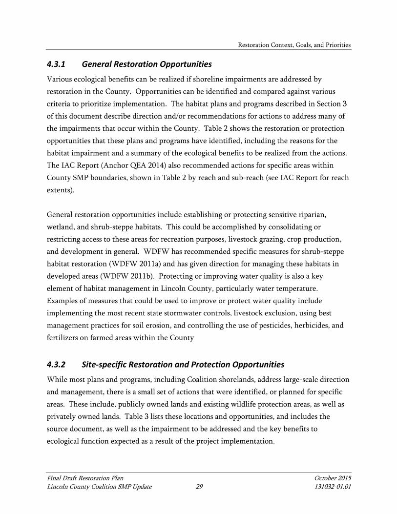
4.3.1 General Restoration Opportunities
Various ecological benefits can be realized if shoreline impairments are addressed by restoration in the County. Opportunities can be identified and compared against various criteria to prioritize implementation. The habitat plans and programs described in Section 3 of this document describe direction and/or recommendations for actions to address many of the impairments that occur within the County. Table 2 shows the restoration or protection opportunities that these plans and programs have identified, including the reasons for the habitat impairment and a summary of the ecological benefits to be realized from the actions. The IAC Report (Anchor QEA 2014) also recommended actions for specific areas within County SMP boundaries, shown in Table 2 by reach and sub-reach (see IAC Report for reach extents). General restoration opportunities include establishing or protecting sensitive riparian, wetland, and shrub-steppe habitats. This could be accomplished by consolidating or restricting access to these areas for recreation purposes, livestock grazing, crop production, and development in general. WDFW has recommended specific measures for shrub-steppe habitat restoration (WDFW 2011a) and has given direction for managing these habitats in developed areas (WDFW 2011b). Protecting or improving water quality is also a key element of habitat management in Lincoln County, particularly water temperature. Examples of measures that could be used to improve or protect water quality include implementing the most recent state stormwater controls, livestock exclusion, using best management practices for soil erosion, and controlling the use of pesticides, herbicides, and fertilizers on farmed areas within the County
4.3.2 Site-specific Restoration and Protection Opportunities
While most plans and programs, including Coalition shorelands, address large-scale direction and management, there is a small set of actions that were identified, or planned for specific areas. These include, publicly owned lands and existing wildlife protection areas, as well as privately owned lands. Table 3 lists these locations and opportunities, and includes the source document, as well as the impairment to be addressed and the key benefits to ecological function expected as a result of the project implementation.
Restoration Context, Goals, and Priorities
Final Draft Restoration Plan October 2015 Lincoln County Coalition SMP Update 30 131032-01.01
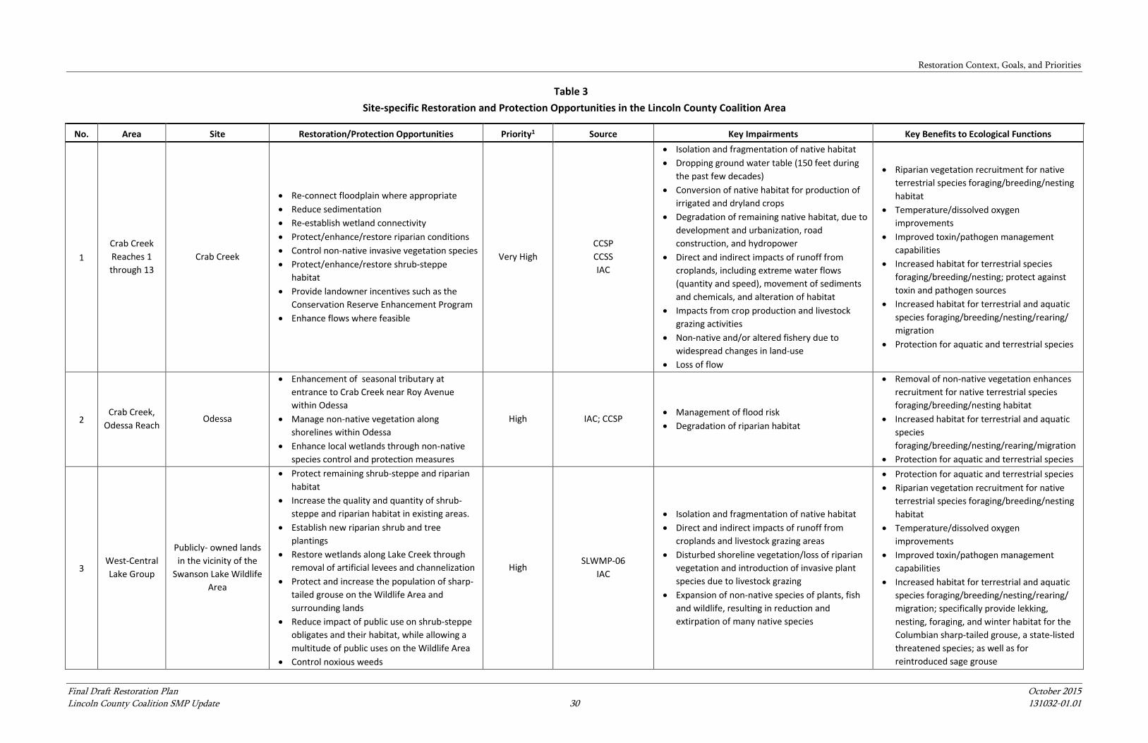
Table 3 Site-specific Restoration and Protection Opportunities in the Lincoln County Coalition Area
No. Area Site Restoration/Protection Opportunities Priority1 Source Key Impairments Key Benefits to Ecological Functions
1 Crab Creek Reaches 1 through 13
Crab Creek
• Re-connect floodplain where appropriate • Reduce sedimentation • Re-establish wetland connectivity • Protect/enhance/restore riparian conditions • Control non-native invasive vegetation species • Protect/enhance/restore shrub-steppe
habitat • Provide landowner incentives such as the
Conservation Reserve Enhancement Program • Enhance flows where feasible
Very High CCSP CCSS IAC
• Isolation and fragmentation of native habitat • Dropping ground water table (150 feet during
the past few decades) • Conversion of native habitat for production of
irrigated and dryland crops • Degradation of remaining native habitat, due to
development and urbanization, road construction, and hydropower
• Direct and indirect impacts of runoff from croplands, including extreme water flows (quantity and speed), movement of sediments and chemicals, and alteration of habitat
• Impacts from crop production and livestock grazing activities
• Non-native and/or altered fishery due to widespread changes in land-use
• Loss of flow
• Riparian vegetation recruitment for native terrestrial species foraging/breeding/nesting habitat
• Temperature/dissolved oxygen improvements
• Improved toxin/pathogen management capabilities
• Increased habitat for terrestrial species foraging/breeding/nesting; protect against toxin and pathogen sources
• Increased habitat for terrestrial and aquatic species foraging/breeding/nesting/rearing/ migration
• Protection for aquatic and terrestrial species
2 Crab Creek,
Odessa Reach Odessa
• Enhancement of seasonal tributary at entrance to Crab Creek near Roy Avenue within Odessa
• Manage non-native vegetation along shorelines within Odessa
• Enhance local wetlands through non-native species control and protection measures
High IAC; CCSP • Management of flood risk • Degradation of riparian habitat
• Removal of non-native vegetation enhances recruitment for native terrestrial species foraging/breeding/nesting habitat
• Increased habitat for terrestrial and aquatic species foraging/breeding/nesting/rearing/migration
• Protection for aquatic and terrestrial species
3 West-Central Lake Group
Publicly- owned lands in the vicinity of the
Swanson Lake Wildlife Area
• Protect remaining shrub-steppe and riparian habitat
• Increase the quality and quantity of shrub-steppe and riparian habitat in existing areas.
• Establish new riparian shrub and tree plantings
• Restore wetlands along Lake Creek through removal of artificial levees and channelization
• Protect and increase the population of sharp-tailed grouse on the Wildlife Area and surrounding lands
• Reduce impact of public use on shrub-steppe obligates and their habitat, while allowing a multitude of public uses on the Wildlife Area
• Control noxious weeds
High SLWMP-06
IAC
• Isolation and fragmentation of native habitat • Direct and indirect impacts of runoff from
croplands and livestock grazing areas • Disturbed shoreline vegetation/loss of riparian
vegetation and introduction of invasive plant species due to livestock grazing
• Expansion of non-native species of plants, fish and wildlife, resulting in reduction and extirpation of many native species
• Protection for aquatic and terrestrial species • Riparian vegetation recruitment for native
terrestrial species foraging/breeding/nesting habitat
• Temperature/dissolved oxygen improvements
• Improved toxin/pathogen management capabilities
• Increased habitat for terrestrial and aquatic species foraging/breeding/nesting/rearing/ migration; specifically provide lekking, nesting, foraging, and winter habitat for the Columbian sharp-tailed grouse, a state-listed threatened species; as well as for reintroduced sage grouse
Restoration Context, Goals, and Priorities
Final Draft Restoration Plan October 2015 Lincoln County Coalition SMP Update 31 131032-01.01
Table 3 Site-specific Restoration and Protection Opportunities in the Lincoln County Coalition Area
No. Area Site Restoration/Protection Opportunities Priority1 Source Key Impairments Key Benefits to Ecological Functions
4 East-central Lake Group;
Reardan
Publicly-owned lands in the vicinity of the
Reardan Audubon Lake Wildlife Area
• Protect/enhance/restore shrub-steppe habitat
• Protect/enhance/restore wetland habitat • Protect water quality • Preserve upland and waterfowl habitat • Provide formalized recreational trail access;
fence off smaller desire trails
High SLWMP-14
IAC
• Direct and indirect impacts of runoff from croplands and livestock grazing areas on water quality and water quantity
• Disturbed shoreline vegetation/loss of riparian vegetation and introduction of invasive plant species due to livestock grazing
• Expansion of non-native species of plants, fish and wildlife, resulting in reduction and extirpation of many native species
• Reduced or disturbed shoreline vegetation due to recreational activities; informal trails
• Improved toxin/pathogen management capabilities
• Increased habitat for terrestrial species foraging/breeding/nesting; protect against toxin and pathogen sources
• Increased habitat for terrestrial and aquatic species foraging/breeding/nesting/rearing/ migration
• Protection for aquatic and terrestrial species
4 Spokane River Recreation areas at
Fort Spokane
• Protect remaining shrub-steppe and riparian habitat
• Provide education to visitors on habitat types • Increase the quality and quantity of shrub-
steppe by fencing Providing formalized recreational trail access; fence off smaller desire trails between campgrounds and docks
• Consider riparian planting combined with curb cuts at boat launch parking lot to provide stormwater irrigation to planted areas
Moderate IAC • Isolation and fragmentation of native habitat
• Riparian vegetation recruitment for native terrestrial species foraging/breeding/nesting habitat
• Increased habitat for terrestrial species foraging/breeding/nesting; protect against toxin and pathogen sources
• Increased habitat for terrestrial and aquatic species foraging/breeding/nesting/rearing/ migration
5 Spokane River
Irrigated Agricultural Field adjacent to
Chamokane Drive East (downstream of Little
Falls dam)
• Provide landowner incentives towards replanting mass wasting landslide areas to re-establish riparian habitat within these gaps in the riparian buffer
Moderate IAC • Water quality impacts from agricultural runoff • Isolation and fragmentation of native habitat
• Improved toxin/pathogen management capabilities
• Increased habitat for terrestrial species foraging/breeding/nesting; protect against toxin and pathogen sources
• Increased habitat for terrestrial and aquatic species foraging/breeding/nesting/rearing/migration
• Protection for aquatic and terrestrial species

Restoration Context, Goals, and Priorities
Final Draft Restoration Plan October 2015 Lincoln County Coalition SMP Update 32 131032-01.01
Table 3 Site-specific Restoration and Protection Opportunities in the Lincoln County Coalition Area
No. Area Site Restoration/Protection Opportunities Priority1 Source Key Impairments Key Benefits to Ecological Functions
6 Lake
Roosevelt
Keller Wilbur Ferry/Keller Wilbur
Marina area and Campground
• Protect remaining shrub-steppe and riparian habitat
• Increase the quality and quantity of shrub-steppe by formalizing trails between boat launch and car parking near marina/boat launch, and also formalizing trails between campground area and ferry shoreline area
• Consider riparian planting combined with curb cuts at marina boat launch parking lot to provide stormwater irrigation to planted area
High IAC • Isolation and fragmentation of native habitat
• Riparian vegetation recruitment for native terrestrial species foraging/breeding/nesting habitat
• Increased habitat for terrestrial species foraging/breeding/nesting; protect against toxin and pathogen sources
• Increased habitat for terrestrial and aquatic species foraging/breeding/nesting/rearing/migration
• Protection for aquatic and terrestrial species
7 Lake
Roosevelt
Redwine Canyon Road Boat launch
(Redwine Canyon Road North and East Mill
Drive)
• Consider fenced shrub steppe habitat restoration with educational signs in area south of trailer parking lot
• Consider riparian planting combined with curb cuts at boat launch parking lot (east of lot) to provide stormwater irrigation to planted areas
Moderate IAC • Isolation and fragmentation of native habitat
• Riparian vegetation recruitment for native terrestrial species foraging/breeding/nesting habitat
• Increased habitat for terrestrial species foraging/breeding/nesting; protect against toxin and pathogen sources
• Increased habitat for terrestrial and aquatic species foraging/breeding/nesting/rearing/ migration
• Protection for aquatic and terrestrial species
Notes: 1 - Very High – Habitat protection projects or actions that have a high likelihood of successfully addressing restoration of ecosystem functions and a high certainty of funding; or address critically important species and habitat concerns; High – Restoration of ecosystem functions (funded actions take higher priority within this category); Moderate – Restoration of habitat structure (funded actions take higher priority within this category) CCSP = Crab Creek Subbasin Plan (KWA 2004) CCSS = Crab Creek Subbasin Summary (WDFW 2001) IAC = Inventory, Analysis, and Characterization Report (Anchor QEA 2014) SLWMP-06 = Swanson Lakes Wildlife Area Management Plan (WDFW 2006) SLWMP-14 = Swanson Lakes Wildlife Area Management Plan (WDFW 2014)
Restoration Context, Goals, and Priorities
Final Draft Restoration Plan October 2015 Lincoln County Coalition SMP Update 33 131032-01.01
4.4 Project Evaluation and Prioritization Criteria
Projects and opportunities in this Restoration Plan can be evaluated against various criteria to prioritize implementation. The following list includes a description of criteria that indicate that a project is viewed as implementable under this Plan:
• Meet goals and objectives for shoreline restoration (Section 4.2 of this document). • Maintain consistency with existing plans and programs as described in Section 3 of
this document. • Have public support. • Be located on public property or property owned by a willing partner in restoration
projects. • Restore ecosystem processes or provide habitat protection (those that restore function
by providing habitat structure only would take a lesser priority). • Improve a rapidly deteriorating habitat condition. • Have high benefit to ecosystem function relative to cost. • Provide riparian, shoreline, or instream habitat for spawning and rearing listed
salmonids, or improve conditions in sensitive shrub-steppe systems for state and federally listed native wildlife (a list of wildlife are given in WDFW 2011b; e.g., Greater Sage grouse, burrowing owl, Townsend’s ground squirrel)
All specific projects or actions that comprise a project listed in Table 3 exhibit some, if not all, of the previous criteria. To prioritize these actions, they were assigned to a category of Very High, High, and Moderate relative to their value in achieving the SMP goal of no net loss for shorelines within County SMP jurisdiction (see Table 3). Projects were categorized as follows:
• Very High – Habitat protection projects or actions that have a high likelihood of successfully addressing restoration of ecosystem functions and a high certainty of funding, or address critically important species and habitat concerns
• High – Restoration of ecosystem functions (funded actions take higher priority within this category)
• Moderate – Restoration of habitat structure only (funded actions take higher priority within this category)
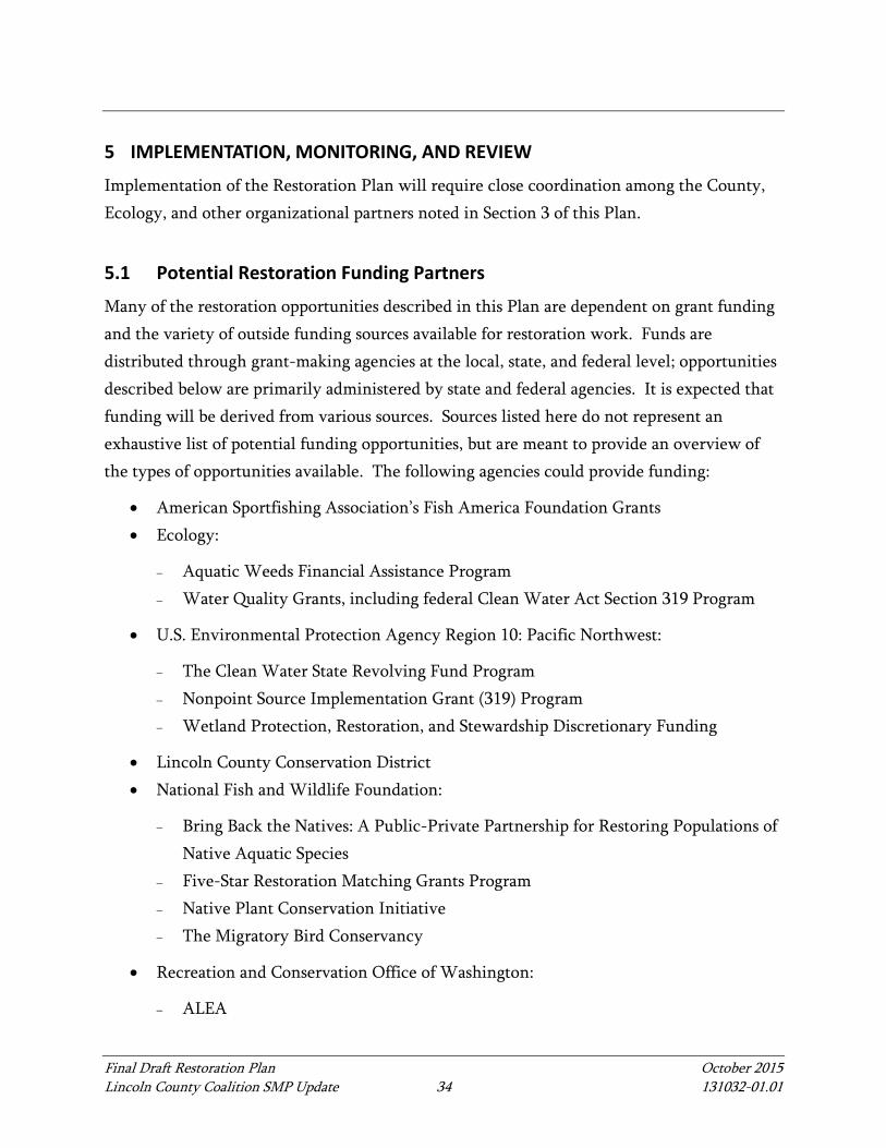
Final Draft Restoration Plan October 2015 Lincoln County Coalition SMP Update 34 131032-01.01
5 IMPLEMENTATION, MONITORING, AND REVIEW
Implementation of the Restoration Plan will require close coordination among the County, Ecology, and other organizational partners noted in Section 3 of this Plan.
5.1 Potential Restoration Funding Partners
Many of the restoration opportunities described in this Plan are dependent on grant funding and the variety of outside funding sources available for restoration work. Funds are distributed through grant-making agencies at the local, state, and federal level; opportunities described below are primarily administered by state and federal agencies. It is expected that funding will be derived from various sources. Sources listed here do not represent an exhaustive list of potential funding opportunities, but are meant to provide an overview of the types of opportunities available. The following agencies could provide funding:
• American Sportfishing Association’s Fish America Foundation Grants • Ecology:
− Aquatic Weeds Financial Assistance Program − Water Quality Grants, including federal Clean Water Act Section 319 Program
• U.S. Environmental Protection Agency Region 10: Pacific Northwest:
− The Clean Water State Revolving Fund Program − Nonpoint Source Implementation Grant (319) Program − Wetland Protection, Restoration, and Stewardship Discretionary Funding
• Lincoln County Conservation District • National Fish and Wildlife Foundation:
− Bring Back the Natives: A Public-Private Partnership for Restoring Populations of Native Aquatic Species
− Five-Star Restoration Matching Grants Program − Native Plant Conservation Initiative − The Migratory Bird Conservancy
• Recreation and Conservation Office of Washington:
− ALEA
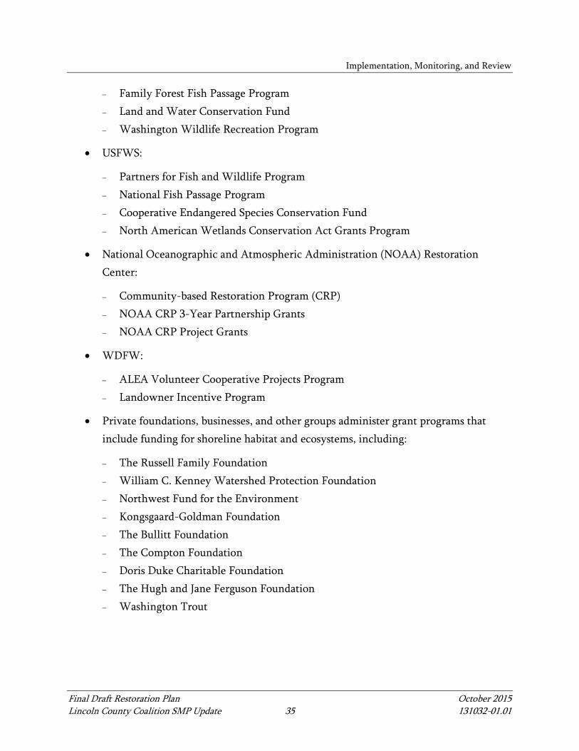
Implementation, Monitoring, and Review
Final Draft Restoration Plan October 2015 Lincoln County Coalition SMP Update 35 131032-01.01
− Family Forest Fish Passage Program − Land and Water Conservation Fund − Washington Wildlife Recreation Program
• USFWS:
− Partners for Fish and Wildlife Program − National Fish Passage Program − Cooperative Endangered Species Conservation Fund − North American Wetlands Conservation Act Grants Program
• National Oceanographic and Atmospheric Administration (NOAA) Restoration Center:
− Community-based Restoration Program (CRP) − NOAA CRP 3-Year Partnership Grants − NOAA CRP Project Grants
• WDFW:
− ALEA Volunteer Cooperative Projects Program − Landowner Incentive Program
• Private foundations, businesses, and other groups administer grant programs that include funding for shoreline habitat and ecosystems, including:
− The Russell Family Foundation − William C. Kenney Watershed Protection Foundation − Northwest Fund for the Environment − Kongsgaard-Goldman Foundation − The Bullitt Foundation − The Compton Foundation − Doris Duke Charitable Foundation − The Hugh and Jane Ferguson Foundation − Washington Trout
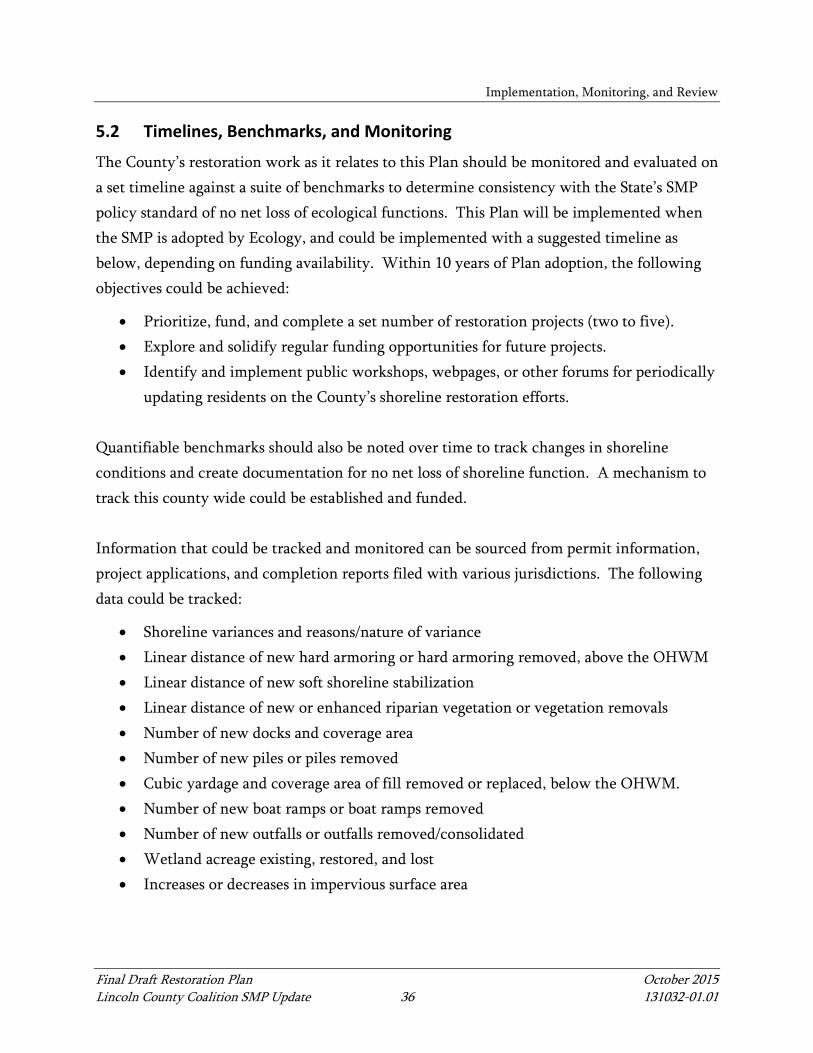
Implementation, Monitoring, and Review
Final Draft Restoration Plan October 2015 Lincoln County Coalition SMP Update 36 131032-01.01
5.2 Timelines, Benchmarks, and Monitoring
The County’s restoration work as it relates to this Plan should be monitored and evaluated on a set timeline against a suite of benchmarks to determine consistency with the State’s SMP policy standard of no net loss of ecological functions. This Plan will be implemented when the SMP is adopted by Ecology, and could be implemented with a suggested timeline as below, depending on funding availability. Within 10 years of Plan adoption, the following objectives could be achieved:
• Prioritize, fund, and complete a set number of restoration projects (two to five). • Explore and solidify regular funding opportunities for future projects. • Identify and implement public workshops, webpages, or other forums for periodically
updating residents on the County’s shoreline restoration efforts. Quantifiable benchmarks should also be noted over time to track changes in shoreline conditions and create documentation for no net loss of shoreline function. A mechanism to track this county wide could be established and funded. Information that could be tracked and monitored can be sourced from permit information, project applications, and completion reports filed with various jurisdictions. The following data could be tracked:
• Shoreline variances and reasons/nature of variance • Linear distance of new hard armoring or hard armoring removed, above the OHWM • Linear distance of new soft shoreline stabilization • Linear distance of new or enhanced riparian vegetation or vegetation removals • Number of new docks and coverage area • Number of new piles or piles removed • Cubic yardage and coverage area of fill removed or replaced, below the OHWM. • Number of new boat ramps or boat ramps removed • Number of new outfalls or outfalls removed/consolidated • Wetland acreage existing, restored, and lost • Increases or decreases in impervious surface area
Implementation, Monitoring, and Review
Final Draft Restoration Plan October 2015 Lincoln County Coalition SMP Update 37 131032-01.01
5.3 Shoreline Master Program Review
The County will be required to conduct periodic SMP updates, which will include an evaluation of the efficacy of the SMP and this Plan. This review will involve comparing past conditions with existing conditions, and assessing whether the actions, policies, and regulations set since the last SMP update have been valuable in ensuring no net loss. The evaluation will be an opportunity to adjust these measures as applicable for the benefit of future shoreline conditions.
Final Draft Restoration Plan October 2015 Lincoln County Coalition SMP Update 38 131032-01.01
6 REFERENCES
Anchor QEA (Anchor QEA, LLC), 2014. Draft Shoreline Inventory, Analysis, and Characterization Report, Lincoln County Coalition Shoreline Master Program Update. Prepared for Lincoln County Coalition. May 2014.
Anderson, J., 2006. Swanson Lake Wildlife Area Management Plan, Washington Department of Fish and Wildlife. Available from: http://wdfw.wa.gov/publications/00542/wdfw00542.pdf.
BLM (Bureau of Land Management), 1987. Spokane Resource Management Plan Record of Decision. Prepared for The Spokane District Office. May 1987.
BLM, 2014. South Fork Crab Creek Riparian and Wetland Restoration scoping letter, BLM Spokane Office. Available from: http://www.blm.gov/or/districts/spokane/plans/plans-details.php?id=2818 SF_Crab_Creek__Restoration_Scoping.pdf.
Ecology (Washington State Department of Ecology), 2004. State Master Program Approval\Amendment Procedures and Master Program Guidelines (Chapter 173-26, Part III - Guidelines). Effective January 2004.
ICBEMP (Interior Columbia Basin Ecosystem Management Project), 2003. Interior Columbia Basin Strategy. Available from: http://www.icbemp.gov/.
ICBEMP, 2014. Updated Interior Columbia Basin Strategy. Available from: http://www.icbemp.gov/.
IWJV (Washington Steering Committee Intermountain West Join Venture), 2005. Coordinated Implementation Plan for Bird Conservation in Eastern Washington. Available from: http://iwjv.org/sites/default/files/plan_eastwa_scp.pdf.
KWA (KWA Ecological Sciences Inc.), 2004. Crab Creek Subbasin Plan. Prepared for the Washington Department of Fish and Wildlife and Lincoln County Conservation District. May 26, 2004.
References
Final Draft Restoration Plan October 2015 Lincoln County Coalition SMP Update 39 131032-01.01
LCCD (Lincoln County Conservation District; GSI Water Solutions, Inc.; HDR, Inc.; WNR Group, Inc.), 2010. Prefeasibility Assessment Report for the Lincoln County Passive Rehydration Project (Review Draft). Prepared for the Washington Department of Ecology. December 2010.
Link, S.O., W.H. Mast, and R.W. Hill, 2006. Shrub-steppe. Restoring the Pacific Northwest. D. Apostol and M. Sinclair, editors, pp. 216-240. Island Press, Washington D.C.
Melillo, J.M., T.C. Richmond, and G.W. Yohe (Eds.), 2014. Climate Change Impacts in the United States: The Third National Climate Assessment. U.S. Global Change Research Program. DOI 10.7930/J0Z31WJ2.
NPS (National Park Service), 2015. Official Website – What We Do. Updated: August 10, 2015. Cited: May 11, 2015. Available from: http://www.nps.gov/aboutus/index.htm.
NOAA (National Oceanic and Atmospheric Administration), 2013a. U.S. Climate Data and Maps. Cited: November 25, 2013. Available from: http://www.cpc.ncep.noaa.gov/products/analysis_monitoring/regional_monitoring/CLIM_DIVS/washington.gif.
NOAA, 2013b. Location of U.S. Climate Divisions. Cited: February 7, 2014. Available from: http://www.esrl.noaa.gov/psd/data/usclimdivs/data/map.html#Washington.
NWC (The Northwest Power and Conservation Council), 2014. 2014 Columbia River Basin Fish and Wildlife Program. Document 2014-12. October 2014.
Reclamation (Bureau of Reclamation), 2012. 2012 Odessa Subarea Special Study Final Environmental Impact Statement. Ecology Publication No. 12-12-014. August 2012.
Reclamation, 2015. Draft Environmental Assessment for Two Shoreline Protection Systems at Lake Roosevelt Grand Coulee Project, Washington. February 2015.
Thom, R.M., G. Williams, A. Borde, J. Southard, S. Sargeant, D. Woodruff, J.C. Laufle, and S. Glasoe, 2005. Adaptively addressing uncertainty in estuarine and near coastal restoration projects. Journal of Coastal Research 40:94-108.
TNC (The Nature Conservancy), 1999. Columbia Plateau Ecoregional Assessment. Available from: http://waconservation.org/projects/ecoregions/.
References
Final Draft Restoration Plan October 2015 Lincoln County Coalition SMP Update 40 131032-01.01
USFWS (U.S. Fish and Wildlife Service), 2008. The Final Hanford Reach National Monument Comprehensive Conservation Plan and Environmental Impact Statement Updated: September 24, 2008. Available from: http://www.fws.gov/hanfordreach/management.html.
Washington State Department of Ecology (Ecology), 2004. A Department of Ecology Report: What Does No Net Loss Mean in the 2003 SMA Guidelines? June 2004.
WDFW (Washington Department of Fish and Wildlife), 2001. Draft Crab Creek Subbasin Summary. Prepared for the Northwest Power Planning Council by WDFW and others. March 2001.
WDFW, 2006. Swanson Lakes Wildlife Area Management Plan. Prepared by Wildlife Area Manager, Juli Anderson. Available from: http://wdfw.wa.gov/lands/wildlife_areas/management_plans/swanson_lakes/.
WDFW, 2011a. Shrub-Steppe and Grassland Restoration Manual for the Columbia River Basin. Updated: October 2011. Available from: http://wdfw.wa.gov/publications/01330/.
WDFW, 2011a. Shrub-Steppe and Grassland Restoration Manual for the Columbia River Basin. October 2011. Available from: http://wdfw.wa.gov/publications/01330/.
WDFW, 2011b. Management Recommendations for Washington’s Priority Habitats. Managing Shrub-steppe in Developing Landscapes. Updated: November 2011. Available from: http://wdfw.wa.gov/publications/01333/wdfw01333.pdf.
WDFW, 2014. Swanson Lakes Wildlife Area Management Plan Public Workshop Summary – FINAL. Accessed May 8, 2015. Available from:http://wdfw.wa.gov/lands/wildlife_areas/management_plans/swanson_lakes/notes_20 140206.pdf.
WHCWG (Washington Wildlife Habitat Connectivity Working Group), 2012. Washington Connected Landscapes Project: Analysis of the Columbia Plateau Ecoregion. Washington Department of Fish and Wildlife, and Department of Transportation, Olympia, Washington. February 2012.
References
Final Draft Restoration Plan October 2015 Lincoln County Coalition SMP Update 41 131032-01.01
WRCC (Western Regional Climate Center), 2012. Cooperative Climatological Data Summaries. Accessed December 4, 2014. Available from: http://www.wrcc.dri.edu/summary/Climsmwa.html.
WRIA (Water Resource Inventory Area), 2008. WRIA 43 Upper Crab/Wilson Creek Detailed Implementation Plan. Prepared by the WRIA 43 Water Resource Management group, Inc. Available from: http://www.co.lincoln.wa.us/Planning/wria43/WRIA%2043%20Draft%20DIP%2011-18-08.pdf.