Embed Size (px)
Citation preview

THE CITY OF •
COLUMBUS A<-,DREW J. GIN- ER MA or<
Application#:
Application Accepted By:
Rezoning Application
111 North Front Street, Columbus, Ohio 43215 Phone: 614-645-4522 • www.columbus.gov jbzs • [email protected]
Date Received: --------------
Fee: ------------------
Assigned Planner: ---------------------------------------
LOCATION AND ZONING BEQUEST: Existing Address or Zoning Number: 2340 South High Street Zip: 43207 Is this application being annexed into the City of Columbus? DYES ■NO (select one)If the site is currently pending annexation, Applicant must show documentation of County Commissioner's adoption of the annexation petition.
Parcel Number for Address or Zoning Number: -"-0--'-10
-"-0
-"-0.C...
7'-
1'-
4-'--'
3'--
______________________ _ D Check here if listing additional parcel numbers on a separate page.
Current Zoning District(s): _C_P_D _____________ Requested Zoning District(s): _C_P_D ________ _
Area Commission or Civic Association: Far South Columbus Area Commission
Proposed Use or reason for rezoning request: To redevelop the property with a convenience store, retail fuel sales, and minimal outdoor display sales. < continue on separate page if necessary)
Proposed Height District: _H_-_3_5 ________________ _ Acreage: _1 _.6_5_+_/-________ _[Columbus City Code Section 3309.14]
APPLICANT: Name: Thorntons LLC c/o Todd Smutz Phone #: 502.572.1294
City/State: Louisville, KY
Ext.: __ _
Zip: 40245 Address: 2600 James Thornton Way
Email: [email protected] Fax#: __________ _
PROPERTY OWNER(S): □Check here if listing additional property owners on a separate page
Name: Muze Property Management LLC Phone#: ____________ Ext.:
Address: P.O. Box 1461 City/State: Grove City, Ohio Zip: 43123
Email:---------------------------------- Fax#: _______ _
ATfQRNEY / AGENT (Check one if applicable):
Name: Michael Shannon
Address: 8000 Walton Parkway, Suite 260
Email: [email protected]
SIGNATURES (All signatures
■ Attorney D Agent
Phone#: 614.335.9320
City/State: New Albany, OH
Ext.:
Zip: 43054
Fax#: --------
APPLICANT SIGNATURE ___ ...:....::....;._,�!.....£.��C/-�';JJ"-4',f(.L:=....::=--==------------------------
PROPERTY OWNER SIGNATURE: _2._����C,..,���tft_��::::::=----------------------ATTORNEY I AGENT SIGNATURE: _ __L.���:::al�fC..._
__,,���!.&'.'.�=:::::::::_ __________________ _
My signature attests to the fact that the attached application package is complete and accurate to the best of my knowledge. I understand that the City staff review of this application is dependent upon the accuracy of the information provided and that any inaccurate or inadequate information provided by me/my firm/etc. may delay the review of this application.
PLEASE NOTE: Incomplete information will result in the rejection of this submittal. Applications must be submitted by appointment. Call 614-645•4522 to schedule.
Please make all checks payable to the Columbus City Treasurer Rev 2/20.slp
7/28/2020
$3,300HF
Z20-060

THE CITY OF •
COLUMBUS Rezoning Application
111 North Front Street, Columbus, Ohio 43215
Phone: 614-645-4522 • www.columbus.gov/bzs • [email protected]
AFFIDAVIT
(See instruction sheet)
APPLICATION#: ---------------ST ATE OF OHIO COUNTY OF FRANKLIN
Being first duly cautioned and sworn (1) NAME _E_r _ic_Z_ a_rt_m_an ____________________ _of(l) MAILING ADDRESS 8000 Walton Parkway, S uite 2 60, New Albany, Ohio 430 5 4
deposed and states that (he/she) is the applicant, agent, or duly authorized attorney for same and the following is a list of the name(s) and mailing address(es) of all the owners ofrecord of the property located at
(2) EXISTING ADDRESS OR ZONING NUMBER _2 _34_0_S _ou_t _h _H�ig�h_S_ t _re_e _t __________ _ for which the application for a rezoning, variance, special permit or graphics plan was filed with the Department of Building and Zoning Services, on (3) ________________________________ _
SUBJECT PROPERTY OWNERS NAME AND MAILING ADDRESS D Check here if listing additional property owners
on a separate page.
APPLICANT'S NAME AND PHONE # (same as listed on front of application)
AREA COMMISSION OR CIVIC GROUP ZONING CHAIR OR CONT ACT PERSON AND EMAIL ADDRESS
(THIS LINE TO BE FILLED OUT BY CITY STAFF)
( 4) Muze Property ManaQement LLCP.O. Box 14614519 Kenny RoadGrove City, Ohio 4312 3
Thorntons LLC c/o Todd S mutz 50 2. 572.1294
(5) Far S outh Columbus Area CommissionRobert Patterson I Mlchael [email protected]@,yahoo.com
and that the attached document (6) is a list of the names and complete mailing addresses, including zip codes, as shown on the County Auditor's Current Tax List or the County Treasurer's Mailing List, of all the owners of record of property within 125 feet of the exterior boundaries of the property for which the application was filed, and all of the owners of any property within 125 feet of the applicant's or owner's property in the event the applicant or the property owner owns the property contiguous to the subject property (7)
SIGNATURE OF AFFIANT (8) � 7 _rr/ - _,,,
Sworn to before me and signed in my presence this ·28',,J--t.. day of �n the year -i,.:;, '2-0SIGNATURE OF NOTARYPUBLIC (8) ;z:__, ;;z'��My Commission Expires: ______ tJ_/lt��---------------
Notary Seal Here .. �-�.:iAi:�/�. AMONL UNDEftHll.L ! ATTOMEY AT L/#1 i =NIie .... tlCllllo\ ! Mi, �-tfll -&lhlloa\ \" . i Sdln 147.IS R.C:
This Affidav1 �res six (6) months after date of notarization.
PLEASE NOTE: Incomplete information will result in the rejection of this submittal. Applications must be submitted by appointment. Call 614·645-4522 to schedule.
Please make all checks payable to the Columbus City Treasurer Rev 2/20.slp
Z20-060
7/28/2020
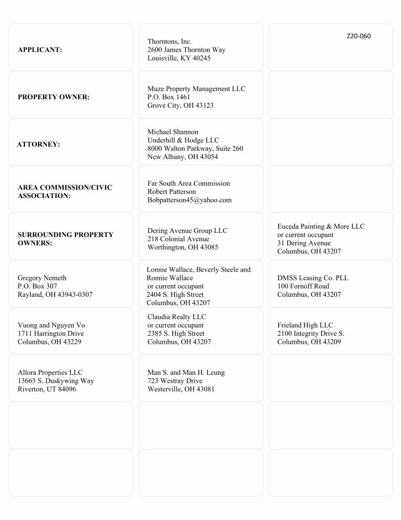
APPLICANT: Thorntons, Inc. 2600 James Thornton Way Louisville, KY 40245
PROPERTY OWNER: Muze Property Management LLC P.O. Box 1461 Grove City, OH 43123
ATTORNEY:
Michael Shannon Underhill & Hodge LLC 8000 Walton Parkway, Suite 260 New Albany, OH 43054
AREA COMMISSION/CIVIC ASSOCIATION:
Far South Area Commission Robert Patterson [email protected]
SURROUNDING PROPERTY OWNERS:
Dering Avenue Group LLC 218 Colonial Avenue Worthington, OH 43085
Euceda Painting & More LLC or current occupant 31 Dering Avenue Columbus, OH 43207
Gregory Nemeth P.O. Box 307 Rayland, OH 43943-0307
Lonnie Wallace, Beverly Steele and Ronnie Wallace or current occupant 2404 S. High Street Columbus, OH 43207
DMSS Leasing Co. PLL 100 Fornoff Road Columbus, OH 43207
Vuong and Nguyen Vo 1711 Harrington Drive Columbus, OH 43229
Claudia Realty LLC or current occupant 2385 S. High Street Columbus, OH 43207
Frieland High LLC 2100 Integrity Drive S. Columbus, OH 43209
Allora Properties LLC 13663 S. Duskywing Way Riverton, UT 84096
Man S. and Man H. Leung 723 Westray Drive Westerville, OH 43081
Z20-060

THE CITY OF •
COLUMBUS ANDREW J C:NTI1EK MftYOK
Rezoning Application
111 North Front Street, Columbus, Ohio 43215 Phone: 614-645-4522 • www.columbus.gov • [email protected]
PROJECT DISCLOSURE STATEMENT
All parties having a 5% or more interest in the project that is the subject of this application should be listed. THIS PAGE MUST BE FILLED OUT COMPLETELY AND NOTARIZED. Do not indicate 'NONE' in the space provided.
STATE OF OHIO COUNTY OF FRANKLIN
APPLICATION#:
Being first duly cautioned and sworn (NAME) �E�r�ic_Z_a�rt�m�a�n ____________________ _ of (COMPLETE ADDRESS) 8000 Walton Parkway, Suite 260 New Albany, Ohio 43054 deposes and states that (he/she) is the APPLICANT, AGENT or DULY AUTHORIZED ATTORNEY FOR SAME and the following is a list of all persons, other partnerships, corporations or entities having a 5% or more interest in the project which is the subject of this application in the following format:
Name of business or individual (include contact name and number) Business or individual's address; City, State Zip Code Number of Columbus based emloyees (Limited to 3 lines per box)
I. 2. Thorntons LLC Muze Property Management LLC 4600 James Thornton Way P.O. Box 1461 Louisville, KY 40245 Grove City, Ohio 43123
3. 4.
D Check here if listing additional parties on a separate page.
:::::::::,:,:�"and before me fuis Y ;f �-� in fue yoa, __ Z-o __ 'U) __
SIGNATURE OF NOTARYPUBLIC � �
My Commission Expires: /J
Notary Seal Here
PLEASE NOTE: Incomplete information will result in the rejection of this submittal. Applications must be submitted by appointment. Call 614-645-4522 to schedule.
Please make all checks payable to the Columbus City Treasurer Rev 2/20.slp
Z20-060

Situate in Section 4, Town 4, Range 22, City of Columbus, Franklin County, Ohio and being part of Lot 2 and Lot 3 of Nathaniel Merion’s Subdivision as recorded in P.B. 1, Pg. 331, and being part of the lands conveyed to Muze Property Management, LLC in O.R. 201212060187090, and being more particularly described as follows:
Beginning at a cross notch set at the intersection of the easterly right of way line of South High Street and the northerly right of way line of Dering Avenue, thence along the easterly right of way line of South High Street and the westerly line of said Muze Property Management, LLC lands, North 03°21’53” West a distance of 250.21 to a point in the easterly right of way line of South High Street, said point witnessed by a cross notch set South 86°38’07” West at a distance of 5.00 feet;
Thence, leaving the easterly right of way of South High Street and along a new division line through the lands of said Muze Property Management, LLC, North 86°38’07”East a distance of 286.23 feet to a 5/8 inch iron pin with cap set in the east line of said Muze Property Management, LLC lands and the west line of the lands conveyed to DMSS Leasing Company, PLL in O.R. 199808270218295;
Thence, along the east line of said Muze Property Management, LLC lands and the west line of said DMSS Leasing Company, PLL lands, South 00°01’32” East a distance of 267.58 feet to a 3/4 inch iron pipe found at a point in the northerly right of way line of Dering Avenue at the southeast corner of said Muze Property Management, LLC lands and the southwest corner of said DMSS Leasing Company, PLL lands;
Thence, along the northerly right of way line of Dering Avenue and the southerly line of said Muze Property Management, LLC lands, North 89°47’18” West a distance of 271.17 feet to the point of beginning;
Containing 1.6549 acres;
Subject to all existing easements and rights of way;
Bearings based on O.R. 201212060187090
Deed Reference of Grantor: O.R. 201212060187090
Prepared by: Baumann Land Survey, Inc., Thomas P. Baumann, PS, Ohio Surveyor #:S-7450
Z20-060

COMMERCIAL PLANNED DEVELOPMENT TEXT
Application: Z20 - _____ Address: 2340 South High Street Parcels: 010-007143 Property Size: +/- 1.65 Acres Current District: CPD Proposed District: CPD Area Commission: Far South Columbus Area Commission Owners: Muze Property Management LLC Applicant: Thorntons LLC Attorney: Michael Shannon, Underhill & Hodge LLC Date: July 27, 2020
I. Introduction.
The subject property (“Site”) is approximately 1.65 +/- acres and located at the northeast corner of South High Street and Dering Avenue. The full 3.3 +/- acre property was rezoned by Ord. 0994-2010 from C-3 to CPD. The property currently operates with auto sales and auto repair establishments. This Site (the 1.65 +/- acre portion of the property) is pavement and was never developed.
To the north across Fornoff Road is a restaurant in the M, Manufacturing District. To the east is undeveloped property zoned in the L-M, Limited Manufacturing District. To the south across Dering Avenue are a single-unit dwelling in the C-4, Commercial District, and a three-unit dwelling in AR-1, Apartment Residential District. To the west across South High Street are a church and a fuel-sales facility in the C-4, Commercial District.
The Site is located within the Far South Columbus Area Commission. The Site is also located within the planning area of the Scioto Southland Plan (2007), which recommends commercial development for this location in accordance with the Community Commercial Overlay.
The Applicant will split the Site upon closing, and redevelop the property with a convenience store, retail fuel sales, and minimal outdoor display sales. The proposed convenience store is approximately 4,516 square feet with 10 double-sided fuel dispensers. The Applicant proposes rezoning the site to a Commercial Planned Development (CPD) to accommodate the new use.
II. Permitted Uses:
Those uses contained in Section 3356.03, C-4, Permitted Uses, and in Section 3357.01, C-5, Permitted Uses, shall be permitted.
III. Development Standards:
060

Unless otherwise indicated in this Text or on the submitted development plan (“CPD Site Plan”), the applicable development standards are contained in Chapter 3356 C-4 Commercial District and Chapter 3372 Planning Overlay of the Columbus City Code shall apply.
A. Density, Height, Lot and/or Setback Requirements:
1. The building and canopy setback shall from South High Street shall be 38 feet and from DeringAvenue shall be 55 feet.
2. The building maximum building setback from the north interior line is 60 feet.
2. The minimum parking setback shall be 5 feet from Dering Avenue.
3. Height shall be as permitted in Chapter 3356 C-4 Commercial District.
B. Access, Loading, Parking, and/or other Traffic Related Commitments:
1. Access points are shown on the submitted CPD Site Plan, which include curb cuts on SouthHigh Street and Dering Avenue, subject to review and approval of the City of Columbus, PublicService Department, Division of Traffic Management.
2. Parking, stacking, and circulation aisles are permitted between the principal building and streetright-of-way lines.
C. Buffering, Landscaping, Open Space and/or Screening Commitments: N/A
D. Building, Design, and/or Interior-Exterior Treatment Commitments:
1. Primary and accessory structures will be developed with uniform design and finishes and shallprimarily be comprised of brick and stone building materials. Canopy columns and dumpstermaterials shall match those used on the primary building.
2. The minimum allowed building width of the South High Street building frontage is 44% of thelot width.
E. Dumpsters, Lighting, Outdoor Areas, and/or other Environmental Commitments: N/A
F. Graphic and Signage Commitments:
Graphics on the Site will comply with the Graphics Code, Article 15, Title 33 of the Columbus City Code as it applies to the C-4 Commercial District for C-4 uses. Variances to the sign requirements shall be submitted to the Columbus Graphics Commission or master graphic plan for the Site may be submitted to the Columbus Graphics Commission for consideration.
G. CPD Criteria:
Z20-060

1. Natural Environment. The Site is approximately 1.65 acres and located at the northeast cornerof South High Street and Dering Avenue. South High Street is a commercial corridor.
2. Existing Land Use. The property is zoned CPD and currently operates with auto sales and autorepair establishments. This Site (the 1.65 +/- acre portion of the property) is pavement and wasnever developed.
3. Transportation and Circulation. The Site is accessed via curb cuts on South High Street andDering Avenue. The internal circuity shall be as shown on the submitted CPD Site Plan.
4. Visual Form of the Environment. The neighborhood is generally developed with manufacturing,commercial and multifamily uses.
5. View and Visibility. The Site can be viewed from South High Street and Dering Avenue.Consideration shall be given to the visibility and safety of motorists in the development of the areaand location of buildings and access points.
6. Proposed Development. To redevelop the property with a convenience store, retail fuel sales,and minimal outdoor display sales.
7. Behavior Patterns. The development and behavior pattern of this area supports commercial andmanufacturing uses.
8. Emission. No adverse effect from emissions shall result from the proposed development.
H. Modification of Code Standards:
3372.704(A) – Building setback requirements from primary street. To increase the required building setback from 25 feet to 37 feet from South High Street.
3372.704(B) – Building setback from non-primary street. To increase the maximum building setback from 25 feet to 55 feet from Dering Avenue.
3372.704(C) – Building setback from interior lot line. To increase the maximum building setback from north interior lot line from 50 feet to 60 feet.
3372.705(B) – Building width. To reduce the minimum building width of the primary building frontage to 44% of the lot width.
3372.709(A) – Parking and circulation. To allow parking, stacking, and circulation aisles between the principal building and street right-of-way lines.
I. Miscellaneous:
1. A development plan titled “CPD Site Plan” showing lot lines, setbacks, and access is submittedfor the development of the Site. The CPD Site Plan may be adjusted to reflect engineering,
Z20-060

topographical or other site data and changes developed at the time of development and engineering plans for all or a portion of the Site affected by said development. Any such adjustment may be reviewed and approved by the Director of the Department of Building and Zoning Services or his/her designee upon submission of the appropriate information regarding the adjustment.
2. Abandoned service stations, filling stations or fuel sales establishments will be addressed inaccordance with 3357.18 of the Columbus City Code.
The undersigned, being the owner of the subject property, together with the Applicant in the subject Application, or their authorized representatives, do hereby agree singularly and collectively for themselves, their heirs, successors and assigns, to abide by above restrictions.
Respectfully Submitted,
__________________________ Michael Shannon Attorney for Applicant
Z20-060

I I I I
I I I I I I I I I I I I I I I I
"
0
I I
[:;J I 1" I ,!
I I
" G
"
I
"' o
" "
I
"
C::)
�
" I "0
G
G
G
<?-c' ,s
no no
OU
--
� ou-------
0 U -----------
OU I
0
M
M
M
no ---------no
I
II
---------no �
1
no
II
. r
�: w I : I
ou
j 7
no
L.
G
J
· •·@
@
"' @
. : ..
... ·. •
, .G
G
G
(;
40
'
•
�
. ' . .. ....
"'" . ,J. ..... .
_,..:. .. . •
ci
I
'\�iw
I
4 0 '
'
4 0 ' 0
3+D
,-=-□ �
�,
3+D ••
. . .... .
. . •
4 0 '
9.5
'
45
'
D
VENUE
M
M
----
�rsq'RIW)
----
I I
I I
I I
i\
---
--
-
Gl
""
!:im
•-<
m
. . j m
/TI
··Yg\A �-
4.
. ...
I I •
... .&
:111 .
.
.•: ..
... 4
_;...
._.,· . . i
. . .. .
•. ,.
I I I I I
D D D I
I
R
--
"w·�
no-
--
no
-_
_
--
---o
--
M
M
M
7l I \.," .•. ,."
w/C
ap (#74
08
)
Fnd. ¾" I.P
ipe
M
no-
--
no-
__
no
--
-no
M
M
M-
Fron
t: WEST
Rear: EA
ST
Side: NO
RTH
Side: SOU
TH
Min
imum
Maxim
um
PR
OP
OS
ED
LEG
EN
D
PROPERTY LINE
BUILDING SETilACK LINE
�
PROPOSED LIGHT POLE
�
PROPOSED ELECTRIC VEHICLE CHARGING
(FUTURE)
SITE
LEG
EN
D
A.PROPO
SED MO
NUMENT SIG
N. SEE SIGNAG
E PACKAGE FOR DETAILS.
B.UNDERGRO
UND STORAG
E TANKS.
C.STANDARD CONCRETE REINFORCED SLAB W
ITH 5' BUFFER AROUND THE OUTSIDE BEYO
NDCANO
PY DRIP EDGE.
D.PROPO
SED HARDSCAPE. REFER TO THO
RNTON$ ST AND ARD DETAIL.
E. PROPOSED AIR SERVICE ISLAND.
F.CONCRETE SIDEW
ALK. REFER TO THO
RNTON$ STANDARD DETAIL.
G.
PIPE BOLLARD. REFER TO THO
RNTON$ STANDARD DETAIL.
H.ACCESSIBLE PARKING
SPACE.
I.BUILDING
SETBACK LINE.
J.W
ASTE ENCLOSURE
K.TYPE
D CURB. REFER TO THORNTONS STANDARD DETAIL.
L START/END M
OUNTABLE CURB. REFER TO THORNTONS STANDARD DETAIL.
M. PROPOSED 3 0' PO
LE SIGN. SEE SIG
NAGE PACKAG
E FOR DETAILS.
N. PROPOSED GREASE TRAP.
0.
TYPE F CURB. REFER TO THORNTO
N$ STANDARD DETAIL.
P.ELECTRIC VEHICLE CHARGING
STATION.
Q.5' PARKING
BUFFER
R RELO
CATED LIGHT POLE.
S. 8' CHAIN LINK FENCE.
LO
CA
TIO
N N
OT
ES
1.ALL DIM
ENSIONS ARE TO
THE EDGE O
F PAVEMENT AND/OR BACK O
F CURB, UNLESSOTHERW
ISE NOTED.
2.ALL RADII ARE 5' AND
TO FACE O
F CURB UNLESS OTHERWISE NO
TED.
3.PARKING
LOT STRIPING
SHALL BE 4" WIDE YELLO
W HIG
HWAY-TYPE STRIPING
APPLIED INACCO
RDANCE WITH THE PLAN
4. REFER TO
LANDSCAPE PLAN FO
R PROPOSED LANDSCAPING LOCATION AND DETAILS.
5. LIG
HT POLES AND LANDSCAPE LIGHTING
ARE SHOWN FO
R COORDINATION PURPOSES
ONLY. SEE ELECTRICALJ
PHOTO
METRIC PLAN FO
R DETAILS.
Require
d P
rovided
Buildin
g Setb
ack
25
38
50 80
50 60
25 55
Parkin
g
2
31
N/A
N/A
Truck/Trailer P
arking
N/A
N/A
Acce
ssible
/Van
Accessib
le 2
Land U
se D
ata
Max. Bu
ilding H
eight
Zonin
g Catego
ry/Zonin
g Age
ncy
Zonin
g Cate
gory 1
Zonin
g Cate
gory 2
Total Site
Are
a
Buildin
g Area
Existing Bu
ilding A
rea
Onsite V
ehicu
lar Circu
lation (p
aved)
Onsite O
pen Sp
ace
Onsite Site
Sidew
alk
Tank P
ad A
rea
Can
op
y Are
a
Off
-site sid
ew
alk area
Drive
way ap
ron
/turn
ou
t area
Off
-site ro
adw
ay imp
rove
ments
OHIO---�
Utilities Protection 81
1 or
1-800
-362
-2764
SERVI
CE
Call &for
, You
Dig
lSTO
RY
CP
D
N/A
N/A
30,000 S.F.
N/A
N/A
N/A
N/A
N/A
N/A
N/A
N/A
N/A
N/A
2
1 STO
RY
CP
D
N/A
N/A
1.6
5 AC
.
4,516 S.F.
451 S.F.
23,2
63 S.F.
24,886
S.F.
3,102 S.F.
1,755 S.F.
5,356 S.F.
1,03
5 S.F.
1,550 S.F.
N/A
z
0
I-
en
a:::(_)
0(/)
w
Cl
en
w
!;;: Cl
0
z
.:J
I-w
z
z
OJ
0
w
�
a:,
(/)
�
::::i
0
(/)
w
z
N
w
z
z
LL
a:::
0
(0
0
0
�
�
N
�
N
a:::a:,
�
a.
�
(',.
w
z
(_)
I-!;;:
(.9
a:::
(/)
(/)
�
(.9
Cl
w
w
Cl
a:::
Cl)
z0
I-N
0
<(
Cl
N
'
...J
(.9
a..
z
::!?:
I-LL
w
>-�
!;;:
a::
Cl
Cl
<(
zI-
N-
Cl
II
�
a.�
z
(.9
w
...J
(/)
(3
ww
Cl
(/)
a::
a..
(.9
z
-z
w
::s0
a..
w
oes
I-(/)
I
(.9-I ■
Cl)
�
u..i
�
,§
(.9
::c
z
0
Cl
::::i
o6
OJ
�
i----:
�
(/)
::c
0
(.9
(_)
::c
�
(/)
C3
.0
CPD
Z20-060

SITE
Z20-060
2340 S. High St.
Approximately 1.65 acres
CPD to CPD

Scioto Southland Plan (2007)
SITE
Z20-060
2340 S. High St.
Approximately 1.65 acres
CPD to CPD

SITE
Z20-060
2340 S. High St.
Approximately 1.65 acres
CPD to CPD


