Embed Size (px)
Citation preview

Draft Environmental Scoping Report
Emang Mmogo Mining Resources PTY LTD
EMANG MMOGO MANGANESE MINE
September 2013
NC/EIA09/SIY/TSA/POS /2013
NCP/EIAl0000230/20 12

DRAFT ENVIRONMENTAL SCOPING REPORT
FOR THE
PROPOSED EMANG MMOGO MANGANESE MINE
Prepared by Ecological Management Services
P.O. Box 110470 Hadison Park
8306
On Behalf of: Emang Mmogo Mining Resources PTY LTD
Office no 4 & 5, 93 Eric Louw Street Hartswater
P.O. Box 716 Hartswater
8750
September 2013

EXECUTIVE SUMMARY
Background Information
Emang Mmogo Mining Resources (Pty) Ltd propose to establish an open-pit mine on the
properties, Portion 4 (A portion of Japies Rus) of the Farm Magoloring 668, Portion 5 (A
portion of Marthaspoort) of the Farm Magoloring 668 and Portion 2 (A portion of
Marthaspoort) of the Farm Mogoloring 668, near Postmasburg in the Northern Cape
The proposed development project is located on the western limb of the Postmasburg
Manganese Field. This area has been characterised by low-medium grades manganese
(<44%Mn). The area was previously mined by Associated Manganese Mines of South
Africa (Assmang) Ltd in the 1960-mid 1980’s. Assmang ceased their operations in the
area after the discovery of high grade manganese (>44% Mn) on the Kalahari Manganese
Field to the north and the mine was abandoned. No rehabilitation was undertaken after
Assmang ceased their operations and large volumes of stockpiles and open-pits still
remain on site.
Prospecting activity has been carried out on the property to determine the resource
reserve and distribution. This information has been carried forward to guide the mine
work programme.
Results from the drilling and subsequent prospecting indicated that the majority of the
resource at the Emang Manganese Project lies within 30 metres of the surface and is
likely to be amenable to shallow open pit mining with a low waste to ore ratio.
The Process
In order to undertake mining related activities an environmental authorisation is required.
In order to obtain environmental authorisation an impact assessment must be
conducted. This development is currently in the first phase of the impact assessment,
namely the Environmental Scoping study (ESS) Phase. The first chapter of the ESS
describes the structure of the document and provides information on how to comment on
the proposal.
Study approach and methodology
This part of the report provides an overview of the study approach and methodology for
the scoping study, with a focus on the legislative framework and guiding principles. A list
of legislation that applies to the project is provided and, for the most important
legislation, a short description of how it applies to the project is given. The most
important legislation includes the National Environmental Management Act (Act no 107
of 1998). This section of the report also provides the objectives of the study and
describes the scoping and public consultation process.

The Proposed Project
This project entails the mining of manganese and iron ore by means of open pit mining.
The ore will be mined from an open pit section using conventional truck and shovel
methods. Ore will be drilled and blasted in the open pit section, loaded onto haul trucks
and transported to a crushing site. After crushing the ore will then be stockpiled and
processed. The finished product will be transported off-site by rail and trucks.
A lternatives
The EIA regulations state that a “reasonable” range of alternatives need to be
investigated as part of the EIA process. These alternatives may fall within the following
categories;
• Demand alternatives – e.g. using energy more efficiently, rather than building
more capacity.
• Activity alternatives - e.g. providing public transport rather than increasing road
capacity.
• Location alternatives – e.g. either for the entire proposal or for components within
the proposal.
• Process alternatives – e.g. the re-use of process water in an industrial plant.
• Scheduling alternatives – e.g. where a number of measures might play a part in
an overall programme, but the order in which they are schedules will contribute to
the overall effectiveness of the end result
• Input alternatives – e.g. use of alternative raw materials or energy sources
• The no-go option – the option not to act
Not all alternatives can be investigated in detail. An analysis of a range of alternatives is
presented in this scoping report to identify any that should be carried forward for further
investigation in the EIA phase.
The Study Area
The Emang Mmogo project is located in the Northern Cape Province of South Africa,
approximately 30km north of Postmasburg.
The Manganese deposits of the Emang project belong to the bixbyite rich Western
Manganese Belt of the Postmasburg Manganese Field.
The topography is mountainous with high open hills and ridges. The study area falls with
the Ag & Ib, land types, a land-type being an area that is uniform with respect to terrain
form, soil patterns and climate. The area is described as non-arable low potential grazing
land. The grazing capacity is between 16 -29 ha per LSU. Most of the area immediately
surrounding the study area is also subject to mining projects. The other landuse is
extensive domestic stock farming.

The study area falls with three vegetation types, Kuruman Mountain Bushveld, Kuruman
Thornveld and Olifantshoek Plains Thornveld. The area has been subjected to previous
mining activity that was not rehabilitated and consequently waste dumps and open pits
cover much of the study area. Most of the disturbed areas have been re-colonised by
vegetation. Although bare patches of exposed substrate are evident, there are many
small trees and shrubs through the area. The vegetation within the disturbed areas is
however considered secondary in nature.
There is the potential that some faunal species of conservation concern may occur within
the study area.
The study area lies within the Lower Vaal Water Management Area. There is a non-
perrenial water course in the center of the study area. The groundwater table depth in
the area ranges between 13.66 and 60.5 mbgl. In general water quality in the area is
within the standards for domestic use, there are some areas that have high manganese
concentrations. This can be associated with the natural occurrence of manganese in this
area. The levels of N03-N concentration in some areas are also high which could be
related to livestock farming activities.
No post-Stone Age/colonial era heritage traces were noted to occur within the study area,
No heritage traces of the nineteenth-twentieth century were noted in the area.
Numerous mining related activities exist in the area to the south and north of the project
area. The undulating nature of the terrain within the proposed mining area however
limits the extent of visual intrusions. The area has already been disturbed by previous
mining activity the result is a landscape with a fairly poor sense of place and a moderate
to low scenic quality.
The most important employer in the Municipal Area is the mining sector
Issues related to the proposed development
This section of the report provides a summary of the issues and concerns raised during
scoping. These include the following:
• Loss and sterilisation of mineral resources
• Hazardous excavations and infrastructure
• Loss of soil and change in land capability through pollution, erosion or
compaction
• Loss of natural vegetation and animal life
• Alteration of surface drainage patterns
• Contamination of surface water

• Reducing groundwater levels and availability
• Contamination of groundwater
• Pollution from emissions to air
• Increase in disturbing noise levels
• Negative visual impacts
• Loss of or damage to paleontological, archaeological, heritage and cultural
resources
• Impact on existing surrounding agricultural and residential uses
• Disturbance of roads by project-related traffic
• Damage from blasting
• Job creation and impact on local & regional economy
• Influx of people and increased pressure on service infrastructure
Plan of study for the EIA
This section details the study that will be undertaken as part of the next phase, namely
the environmental impact assessment phase. During this phase the impacts of the
issues identified during scoping will be assessed.
Conclusion & way forward
A number of issues have been identified during the initial phase of the scoping process
and these have been listed in this document. Some of these identified issues will
however require further investigation by specialists in order for them to be adequately
addressed in the Environmental Impact Assessment Phase.
The completion of the Scoping Report will involve public notification of the availability of
the Draft Scoping Report (DSR) for review and comment. I&AP’s will be provided with 30
day comment period on the report. The DSR will be updated to a Final Scoping Report
(FSR) giving due consideration to comments received. On completion of the FSR it will be
submitted to DENC (the lead environmental authority).

TABLE OF CONTENTS
1. INTRODUCTION . . . . . . . . . . . . . . . . . . . . . . . . . . . . . . . . . . . . . . . . . . . . . . . . . . . . . . . . . . . . . . . . . . . . . . . . . . . . . . . . . . . . . . . . . . . . . . . 9
1.1. BACKGROUND .......................................................................................................................... 9
1.2. TERMS OF REFERENCE .......................................................................................................... 11
1.3. THE APPLICATION PROCESS .................................................................................................. 12
1.4. STRUCTURE OF THE SCOPING REPORT ................................................................................ 14
1.5. COMMENTS ON THE DSR ....................................................................................................... 15
2. STUDY APPROACH AND METHODOLOGY . . . . . . . . . . . . . . . . . . . . . . . . . . . . . . . . . . . . . . . . . . . . . . . . . . . . . . . . . 16
2.1. OBJECTIVES OF SCOPING ...................................................................................................... 16
2.2. CONSULTATION DURING SCOPING STUDY ........................................................................... 16
2.3. LEGISLATIVE FRAMEWORK .................................................................................................... 18
2.4. SCOPING STUDY APPROACH ................................................................................................. 23
2.5. PUBLIC PARTICIPATION PROCESS ............................................................................................. 24
2.6. ASSUMPTIONS AND LIMITATIONS ............................................................................................. 25
3. PROJECT DESCRIPTION . . . . . . . . . . . . . . . . . . . . . . . . . . . . . . . . . . . . . . . . . . . . . . . . . . . . . . . . . . . . . . . . . . . . . . . . . . . . . . . . . 26
3.1. LAYOUT OF SURFACE INFRASTRUCTURE .............................................................................. 26
3.2: CONSTRUCTION PHASE ACTIVITIES ...................................................................................... 26
3.3. CONSTRUCTION PHASE SUPPORT SERVICES AND FACILITIES ........................................... 27
3.4. OPERATIONAL PHASE ACTIVITIES ......................................................................................... 28
3.5. OPERATIONAL PHASE SUPPORT SERVICES AND FACILITIES .............................................. 30
3.6. DECOMMISSIONING PHASE ACTIVITIES ............................................................................... 32
3.7. CLOSURE PHASE ACTIVITIES ................................................................................................. 32
3.8. TIMING ................................................................................................................................... 33
4. DEVELOPMENT ALTERNATIVES . . . . . . . . . . . . . . . . . . . . . . . . . . . . . . . . . . . . . . . . . . . . . . . . . . . . . . . . . . . . . . . . . . . . . . 34
4.1. TYPES OF ALTERNATIVES ....................................................................................................... 34
5. DESCRIPTION OF THE EXISTING STATUS OF THE ENVIRONMENT . . . . . . . . . . . . . . . . . . . . . . 39
5.1. GEOLOGY ................................................................................................................................ 39
5.2. CLIMATE .................................................................................................................................. 41
5.3. TOPOGRAPHY, LAND TYPE AND SOIL .................................................................................... 43
5.5. LAND CAPABILITY ................................................................................................................... 45
5.6. LAND USE ................................................................................................................................ 45
5.7. FLORA AND FAUNA ................................................................................................................. 47
5.8. HYDROLOGY ........................................................................................................................... 51
5.9. SITES OF ARCHAEOLOGICAL AND CULTURAL INTEREST ...................................................... 54
5.10. AIR QUALITY .......................................................................................................................... 55
5.11. NOISE ................................................................................................................................... 55
5.12. VISUAL ASPECTS .................................................................................................................. 56
5.10. REGIONAL SOCIO-ECONOMIC STRUCTURE/PROFILE ........................................................ 57
6. ISSUES AND CONCERNS . . . . . . . . . . . . . . . . . . . . . . . . . . . . . . . . . . . . . . . . . . . . . . . . . . . . . . . . . . . . . . . . . . . . . . . . . . . . . . . . 60
6.1. POTENTIAL BIOPHYSICAL ENVIRONMENTAL IMPACTS ........................................................ 60
6.2. POTENTIAL HERITAGE ENVIRONMENT IMPACTS .................................................................. 64

6.3. POTENTIAL SOCIO-ECONOMIC ENVIRONMENT IMPACTS .................................................... 64
6.4. POTENTIAL CUMULATIVE IMPACTS ....................................................................................... 66
7. PLAN OF STUDY FOR THE EIA . . . . . . . . . . . . . . . . . . . . . . . . . . . . . . . . . . . . . . . . . . . . . . . . . . . . . . . . . . . . . . . . . . . . . . . . 68
7.1. INTRODUCTION ....................................................................................................................... 68
7.2. ENVIRONMENTAL IMPACT ASSESSMENT ............................................................................. 68
7.3. COMPILATION OF THE DRAFT EIR .......................................................................................... 79
7.4. PUBLIC REVIEW OF DRAFT EIR. ............................................................................................. 80
8. CONCLUSIONS AND WAY FORWARD .. . . . . . . . . . . . . . . . . . . . . . . . . . . . . . . . . . . . . . . . . . . . . . . . . . . . . . . . . . . . . . 81
9. REFERENCES . . . . . . . . . . . . . . . . . . . . . . . . . . . . . . . . . . . . . . . . . . . . . . . . . . . . . . . . . . . . . . . . . . . . . . . . . . . . . . . . . . . . . . . . . . . . . . . 82
APPENDIX 1: PUBLIC PARTICIPATION & I&AP DATABASE APPENDIX 2: DETAILS OF EAP APPENDIX 3: ACKNOWLEDGMENT OF DENC APPLICATION
Ecological Management Services
Emang Mmogo Manganese Project Scoping report 9
1. INTRODUCTION
This Draft Scoping Report (DSR) has been compiled and distributed for review and
comment as part of a process to identify potential impacts of a proposed mining
application by Emang Mmogo Mining Resources (Pty) Ltd on Portion 4 (A portion of Japies
Rus) of the Farm Magoloring 668, Portion 5 (A portion of Marthaspoort) of the Farm
Magoloring 668 and Portion 2 (A portion of Marthaspoort) of the Farm Mogoloring 668.
Interested and Affected Parties (I&AP’s) are asked to comment on the DSR. The document
will then be updated giving due consideration to the comments received.
This chapter provides background to the proposed project, outlines the purpose and
goals of the report and describes the structure of the report
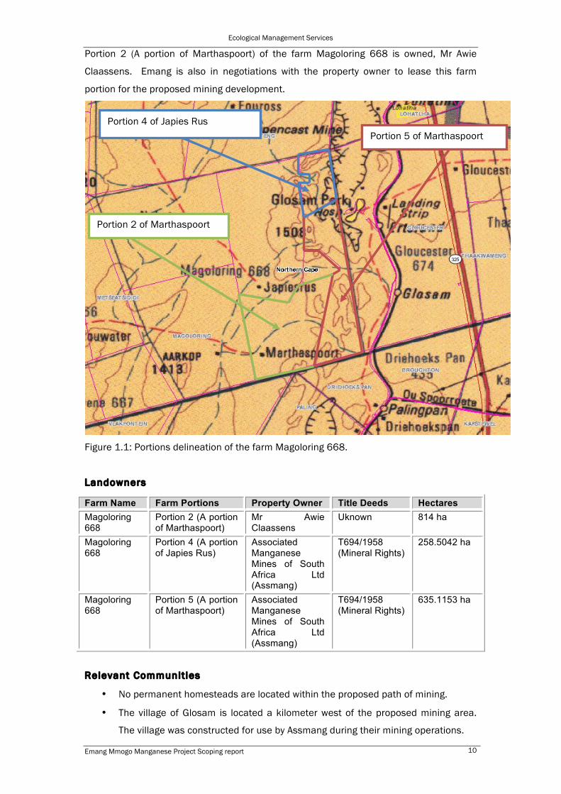
1.1. BACKGROUND
Emang Mmogo Mining Resources (Pty) Ltd has submitted an application to the
Department of Environment and Nature Conservation (DENC) for environmental
authorisation for the proposed establishment of an open-pit mine. The target minerals
are Manganese (Mn) and Iron (Fe) ores. The property on which the application has been
made is Portion 4 (A portion of Japies Rus) of the Farm Magoloring 668, Portion 5 (A
portion of Marthaspoort) of the Farm Magoloring 668 and Portion 2 (A portion of
Marthaspoort) of the Farm Mogoloring 668, constituting a total area of approximately
1668ha.
The proposed development project is located on the western limb of the Postmasburg
Manganese Field. This area has been characterised by low-medium grades manganese
(<44%Mn). The area was previously mined by Associated Manganese Mines of South
Africa (Assmang) Ltd in the 1960-mid 1980’s. Assmang ceased their operations in the
area after the discovery of high grade manganese (>44% Mn) on the Kalahari Manganese
Field to the north and the mine was abandoned. No rehabilitation was undertaken after
Assmang ceased their operations and large volumes of stockpiles and open-pits still
remain on site.
Portion 4 (A portion of Japies Rus) and Portion 5 (A portion of Marthaspoort) of the farm
Magoloring 668 is currently owned by Assmang however Emang Mmogo Mining
Resources are currently in negotiations with Assmang for the surface rights of the
property.
Ecological Management Services
Emang Mmogo Manganese Project Scoping report 10
Portion 2 (A portion of Marthaspoort) of the farm Magoloring 668 is owned, Mr Awie
Claassens. Emang is also in negotiations with the property owner to lease this farm
portion for the proposed mining development.
Figure 1.1: Portions delineation of the farm Magoloring 668.
Landowners
Farm Name Farm Portions Property Owner Title Deeds Hectares Magoloring 668
Portion 2 (A portion of Marthaspoort)
Mr Awie Claassens
Uknown 814 ha
Magoloring 668
Portion 4 (A portion of Japies Rus)
Associated Manganese Mines of South Africa Ltd (Assmang)
T694/1958 (Mineral Rights)
258.5042 ha
Magoloring 668
Portion 5 (A portion of Marthaspoort)
Associated Manganese Mines of South Africa Ltd (Assmang)
T694/1958 (Mineral Rights)
635.1153 ha
Relevant Communit ies
• No permanent homesteads are located within the proposed path of mining.
• The village of Glosam is located a kilometer west of the proposed mining area.
The village was constructed for use by Assmang during their mining operations.
Portion 2 of Marthaspoort
Portion 4 of Japies Rus Portion 5 of Marthaspoort

Ecological Management Services
Emang Mmogo Manganese Project Scoping report 11
• The village of Lohatla is located north east of the site.
Community land ownership
No community landownership exists within the project area. Surface rights of the
project area are currently held by mining companies and a commercial farmer. No
land claims are relevant for the study area.
Relevant tradit ional authority
Not applicable.
Emang Mmogo Mining Resources (Pty) Ltd has been granted Prospecting Rights over
Portion 2 (A portion of Marthaspoort), Portion 4 (A portion of Japies Rus) and Portion 5 (A
portion of Marthaspoort) of the farm Magoloring 668.
Prospecting activity has been carried out on the property to determine the resource
reserve and distribution. This information has been carried forward to guide the mine
work programme.
Results from the drilling and subsequent prospecting indicated that the majority of the
resource at the Emang Manganese Project lies within 30 metres of the surface and is
likely to be amenable to shallow open pit mining with a low waste to ore ratio.
1.2. TERMS OF REFERENCE
Ecological Management Services was approached, as an independent environmental
consultant, to undertake the scoping and impact assessment study required as part of
the process to apply for an environmental authorisation in terms of the National
Environmental Management Act (NEMA).
The scope of work for the Scoping Study includes the following:
• To undertake a scoping and impact assessment study, including compiling a BID,
Scoping Report and Plan of Study for the environmental impact assessment.
• To provide a description of environmental issues identified during the scoping
process for further investigation in the next phase, the Environmental Impact
Assessment;
• To provide for the involvement of IAPs in the identification of issues to be
addressed in the EIA;

Ecological Management Services
Emang Mmogo Manganese Project Scoping report 12
1.3. THE APPLICATION PROCESS
Given that the proposed project is a mine, the relevant authority is the Department of
Mineral Resources (DMR). In order to conduct mining activities, a mining right will be
required which is issued by the DMR. However many of the related activities required to
be conducted for mining operations (such as the construction of pipelines or roads) also
require environmental authorisation under the National Environmental Management Act
(NEMA) Environmental Impact Assessment (EIA) Regulations. An application for
Environmental Authorisation was submitted on the 31 May 2013 to the Department of
Environment and Nature Conservation the relevant authority for the NEMA related
authorisation. The report has been compiled in terms of the National Environmental
Management Act, 107 of 1998(NEMA), and the regulations there under (Regulation
GNR544 and GNR545 of 18 June 2010). Environmental Authorisation has been applied
for the following listed activities
Number and date of the relevant notice
Activity no (in terms of relevant notice)
Description of the listed activity from the regulation
Relevance of the regulation to the project
GNR 544 1 The construction of facilities or infrastructure for the generation of electricity where: i. the electricity output is more than 10 megawatts but less than 20 megawatts; or ii. the output is 10 megawatts or less but the total extent of the facility covers an area in excess of 1 hectare.
• Construction of a substation to supply power to the processing plant and other associated infrastructure on site.
GNR 544 9 The construction of facilities or-infrastructure exceeding' 1000metres in length for the bulk transportation of water, sewage or storm water (i) with an internal diameter of 0,36 metres or more; or (ii) with a peak throughput of 120 litres per second or more,
• Construction of a pipeline for Storm water run off..
• Construction of a pipeline to the Tailings storage facilities
• Pipeline for the transporation of water from the Vaal-Gamagara pipeline which passes on the western side of the proposed site.
GNR 544 10 The construction of facilities or infrastructure for the transmission and distribution of electricity -(i) outside urban areas or industrial complexes with a capacity of more than 33 but less than 275 kilovolts; or
• Construction of overhead electricity power lines to transmit power from the existing Eskom servitudes to the substation to be built on site.
GNR 544 12 The construction of facilities or infrastructure for the off-stream storage of water, including dams and reservoirs, with a combined capacity of 50 000 cubic metres or more, unless such storage falls
• The construction of return water and storm water control dams.

Ecological Management Services
Emang Mmogo Manganese Project Scoping report 13
within the ambit of activity 19 of Notice 545 of 2010.
GNR 544 13 The construction of facilities or infrastructure for the storage, or for the storage and handling, of a dangerous good, where such storage occurs in containers with a combined capacity of 80 but not exceeding 500 cubic metres;
• Diesel and petrol tanks installed on site.
GNR 544 18 The infilling or depositing of any material of more than 5 cubic metres into, or the dredging, excavation, removal or moving of soil, sand, shells, shell grit, pebbles or rock from(i) a watercourse;
• The water from the open pits may be deposited into the dry stream on site.
• Access roads may be constructed on or pass through the dry steam on site.
GNR 544 22 The construction of a road, outside urban area, (ii) where no reserve exists where the road is wider than 8 metres, or (ii) where no reserve exists where the road is wider than 8 metres, or (iii) for which an environmental authorisation was obtained for the route determination in terms of activity 5 in Government Notice 387 of 2006 or activity 18 in Notice 545 of 2010.
• Access roads as well as haul roads will be constructed on site.
GNR 545 11 The construction of railway lines, stations or shunting yards,
• The ore is expected to be transported off site by rail, so a railway siding may be constructed from the site to be connected to the existing line
GNR 545 15 Physical alternation of undeveloped, vacant or derelict land for residential, retail, commercial, recreational, industrial or institutional use where the total area to be transformed is 20 hectares or more
• The proposed development area will exceed 20ha (The area covered will be approximately 1668ha).
GNR 545 19 The construction of a dam, where the highest part of the dam wall, as measured from the outside toe of the wall to the highest part of the wall, is 5 metres or higher or where the high-water mark of the dam covers an area of 10 hectares or more
• The proposed project will require the construction of a slimes dam and storm water control dams.
GNR 545 20 Any activity which requires a mining right or renewal thereof as contemplated in sections 22 and 24 respectively of the Mineral and Petroleum Resources Development Act, 2002 (Act No. 28 of 2002).
• A mining right application has been lodged with the Department of Mineral Resources in terms of MPRDA, 2002 (Act no. 28 of 2002).

Ecological Management Services
Emang Mmogo Manganese Project Scoping report 14
1.4. STRUCTURE OF THE SCOPING REPORT
This report consists of eight chapters, the contents of which are outlined in the table
below.
CHAPTER CONTENT
Chapter 1 Introduction
Provides background to the proposed project
and the terms of reference for the scoping
study. The chapter also describes the
structure of this document
Chapter 2 Study approach and methodology
Provides an overview of the study approach
and methodology for the scoping study, with
a focus on the legislative framework and
guiding principles. Provides the objectives of
the study and describes the scoping and
public consultation process
Chapter 3 Project description
Provides a detailed description of the
proposed project
Chapter 4 Consideration of alternatives Provides an analysis of various alternatives
to the proposed project, including the “do
nothing” alternative, and indicates which of
these alternatives will be carried forward to
be assessed in the EIA phase
Chapter 5 The affected environment
Provides a description of the key
characteristics of the biophysical and socio-
economic environment within which the
proposed project is located.
Chapter 6 Issues and concerns
Provides a summary of the issues and
concerns raised during scoping
Chapter 7 Potential environmental impacts
Chapter 8 Conclusions and Way forward
Provides conclusions from the study and
recommendations on the way forward
Appendices Public participation, I&AP database, details

Ecological Management Services
Emang Mmogo Manganese Project Scoping report 15
of EAP and DENC acknowledgment of
application
Addendum Addendum Comments Report
A comments and response report including
copies of all comments received on this Draft
Scoping Report will be complied as an
addendum to this report
1.5. COMMENTS ON THE DSR
The DSR will be made available for a 30 day comment period in order to provide I&AP’s
with an opportunity to comment on any aspect of the Scoping Study to date.
Copies of the full report will be lodged in the following public libraries/venues for public
review: Postmasburg Library
Digital copies of the report will also be made available on disc for distribution upon
request. The full report will also be made available on the internet for electronic
downloads.
For comments to be included in the Final Scoping Report (FSR), they should reach the
offices of Ecological Management Services by 30 September 2013.
Comments should be forwarded to Ecological Management Services at the contact
details given below.
Ecological Management Services
P.O. Box 110470
Hadison Park
8306
Tel/fax 053 832 1561
Email: [email protected]
Comments and the responses received during this period will be logged in the comments
and response report.

Ecological Management Services
Emang Mmogo Manganese Project Scoping report 16
2. STUDY APPROACH AND METHODOLOGY
This chapter outlines the guiding principles and legislative requirements underpinning the
scoping study, describes the objectives of the study and the process followed.
2.1. OBJECTIVES OF SCOPING
The environmental scoping phase of an EIA has three key objectives:
1. To provide for the involvement of IAPs in the identification of issues to be
addressed in the EIA.
2. To identify reasonable alternatives.
3. To ensure that all key issues and environmental impacts that will be generated by
the project are identified. These can then be comprehensively addressed in the
next phase, the Environmental Impact Assessment.
2.2. CONSULTATION DURING SCOPING STUDY
The broad objective of the public and the authority involvement process is to provide
I&AP’s and authorities with the opportunity to identify issues, concerns and opportunities
regarding the proposed development. Information arising out of this process can be used
to focus the EIA and to enable informed decision-making and planning. The participation
process also assists in identifying ways in which concerns can be addressed and
additional alternatives considered throughout the project’s pre-construction, construction
and operational phases, if authorisation for the project is obtained. A diagrammatic
representation of the application procedure is given in Figure 2.1.

Ecological Management Services
Emang Mmogo Manganese Project Scoping report 17
Contextualise Proposed Development
Pre-application planning (screening) Determine assessment process using NEMA 1998 & associated G/N 385 -387 of 2006
Scoping & Environmental Impact Assessment
Submit application to Authority
Initiate public participation process
Compile Scoping Report & Plan of study for EIA
Public review of scoping report & plan of study for EIA
Authority review of scoping report & Plan of study for EIA
Accept/ reject
Conduct environmental impact assessment. Compile EIR & EMP
Public review of EIR & EMP
Authority review of EIR & EMP
Issue Record of Decision (ROD) and notify the applicant of conditions of approval and appeal procedures
Notify I&APs of Record of Decision and appeal provisions
Consider Appeals if any
Request Amendments
Specialist Review
Note: EIR – Environmental Impact Report EMP – Environmental Management Plan
WE ARE HERE
Figure 2.1: Flow chart of the application process under NEMA

Ecological Management Services
Emang Mmogo Manganese Project Scoping report 18
2.3. LEGISLATIVE FRAMEWORK
Legislation is provided in this section to supply a description of the key legal
considerations of importance to the proposed project. The applicable legislation is listed
below, details on the legislation are provided to elaborate on points relevant to the
project
Legislation Applicable requirements Relevant Authority
Compliance Requirements
National Legislation National Environmental Management Act (Act no. 107 of 1998)
The EIA Regulations have been promulgated in terms of Chapter 5 of the Act. Listed activities which may not commence without an environmental authorisation are identified within these Regulations. In terms of S24(1) of NEMA, the potential impact on the environment associated with these listed activities must be assessed and reported on to the competent authority charged by NEMA with granting of the relevant environmental authorisation. In terms of GNR 387 of 21 April 2006, a Scoping and EIA Process is required to be undertaken for the proposed project.
DENC Listed activities triggered by the proposed mining establishment will be identified and e assessed in the EIA process being undertaken. EIA Report will be submitted to the competent and commenting authority in support of the application for authorisation.
National Environmental Management Act (Act no. 107 of 1998)
In terms of duty care provision in S28(1) the project proponent must ensure that reasonable measure are taken throughout the life cycle of this project to ensure that any pollution or degradation of the environment associated with this project is avoided, stopped or minimised. In terms of NEMA, it has become a legal duty for the project proponent to consider a project holistically, and to consider the cumulative effect of a variety of impacts
DENC This section will find application during the EIA phase through the consideration of potential impacts (cumulative, direct and indirect). It will continue to apply throughout the life cycle of the project.
Environmental Conservation Act (Act no. 73 of 1989)
National Noise Control Regulations (GNR154 dated 10 January 1992)
DENC Local Authorities
Noise impacts are expected to be associated with the construction, operational, decommission as well as closure phases of the project.
National Water Act (Act no. 36 of 1998)
Water uses under S21 of the act must be licensed unless such water use falls under S22 of the act or falls under general authorisation
DWA Provincial Department of Water Affairs
A water use license (WUL) is required for this project.
National Water Act (Act no. 36 of 1998)
In terms of S19, the project proponent must ensure that reasonable measures are throughout the lifecycle of the project to prevent and remedy the
DWA Provincial Department of Water Affairs
This section will apply with respect to the potential impact on drainage lines, storage of slimes and

Ecological Management Services
Emang Mmogo Manganese Project Scoping report 19
effects of pollution to water resources from occurring, continuing or recurring
waste water as well as the effect of dewatering.
Mineral and Petroleum Resources Development Act (Act no. 28 of 2002)
A mining permit or a mining right may be required where a mineral in question is to be mined in accordance with the provisions of the act. Requirements for Environmental Management Programmes and Environmental Management Plans are set out in S39 of the act.
DMR A mining right is required before any mining activity can take place.
National Environmental Management: Air Quality Act (Act no. 39 of 2004)
S18, S19 and S20 of the act allow certain areas to be declared as “priority areas” Declaration of controlled emitters (part 3 of the act) and controlled fuels (part 4 of the act) with relevant emission standards
DEA No permitting or licensing requirements arise from this legislation. Of relevance however is the impact of dust. The Act provides that an air quality officer may require any person to submit an atmospheric impact report if there is reasonable suspicion that the person has failed to comply with the Act.
National Heritage Resources Act (Act no. 25 of 1999)
S38 states that Heritage Impact Assessments (HIAs) are required for certain kinds of developments including:
• The construction of a road, power line, pipeline, canal and other similar linear development or barrier exceeding 300m in length and
• Any development or other activity that will change the character of a site exceeding 500m2 in extent.
Stand alone HIAs are not required where an EIA is carried out as long as the EIA contains an adequate HIA component that fulfils the provision of S38. In such cases only those components not addressed by the EIA must be covered by the heritage component.
SAHRA A permit may be required should identified cultural/ heritage sites on site be required to be disturbed or destroyed as a result of the proposed development. A HIA will be undertaken as part of EIA process to identify heritage site.
National Environmental Management: Biodiversity Act (Act no. 10 of 2004)
In terms of S57, the Minister of environmental affairs has published a list of critically endangered, endangered, vulnerable and protected species GNR151 in Gazette 29657 of 23 February 2007 and the regulation associated therewith in GNR 152 in GG29657 of 23 February 2007, which came into effect in 1 June 2007. In terms of GNR 152 of 23 February 2007: Regulations relating to listed threatened and protected species, the relevant specialist must be employed during the EIA phase of the project to incorporate the legal provisions as well as the regulations associated with listed threatened and protected
DEA Specialist flora and fauna study will be carried out as part of the EIA phase. As such the potential occurrence of critically endangered, endangered, vulnerable and protected species and the potential for them to be affected will be considered. Should protected species occur the relevant permit will be applied for.

Ecological Management Services
Emang Mmogo Manganese Project Scoping report 20
species (GNR 152) into specialist reports in order to identify permitting requirements at an early stage of the EIA phase.
Conservation of Agricultural Resources Act (Act no. 43 of 1983)
Regulation 15 of GNR1048 provides for the declaration of weeds and invader plants, and these are set out in table 3 of GNR 1048. Weeds are described as Category 1 plants, while invader plants are described as Category 2 and Category 3 plants. These Regulations provide that Category 1, 2 and 3 plants must occur on land and that such plants must be controlled by the methods set out in Regulation 15E.
DALRRD This act will find application throughout the life cycle of the project. In this regard, soil erosion prevention and soil conservation strategies must be developed and implemented. In addition, an invader & weed control management plan must be implemented.
National Forests Act (Act 84 of 1998)
In terms of S5(1) no person may cut, disturb, damage or destroy any protected tree or possess, collect, remove, transport, export, purchase, sell, donate or in any other manner acquire or dispose of any protected tree or any forest product derived from a protected tree, except under a license granted by the Minister to an applicant and subject to such period and conditions as may be stipulated GN1042 provides a list of protected tree species
DAFF As protected tree species may be found on the proposed development site, a permit may need to be obtained for any protected trees that are affected by the development.
National Veld and Forest Fire Act (Act no.101 of 1998)
In terms of S21 the applicant would be obliged to burn firebreaks to ensure that should veld fire occur on the property, that it does not spread to adjoining land. In terms of S21 the applicant must ensure that the firebreak is long and wide enough to have a reasonable chance of preventing fire from spreading, not causing erosion and is reasonably free from inflammable material. In terms of S17, the applicant must have such equipment, protective clothing, and trained personnel for extinguishing fire
DAFF While no permitting or license requirements arise from this legislation, the Act will find application during the construction and operational phases of the project.
Hazardous Substance Act (Act no. 15 of 1973)
This act regulates the control of substances that may cause injury, or ill health or death due to their toxic, corrosive, irritant, strongly sensitising and inflammable nature or the generation of pressure thereby in certain instances and for the control of certain electronic products. To provide for the rating of such substances or products in relation to the degree of danger, to provide for the prohibition and control of importation, manufacture, sale, use, operation, modification, disposal or dumping of such substances and products. Group I and II: Any substance or mixture of substance that by reason of
Department of Health
It is necessary to identify and list all Group I, II, III, IV and V hazardous substances that may be on site and what operational context they are used, stored or handled. If applicable a license is required to be obtained from the Department of Health.

Ecological Management Services
Emang Mmogo Manganese Project Scoping report 21
its toxic, corrosive etc., nature or because it generates pressure through decomposition, heat, or other means, cause extreme risk of injury etc., can be declared as Group I or Group II substance. Group IV: Any electronic product, and Group V: Any radioactive material. The use, conveyance or storage of any hazardous substance (such as distillate fuel) is prohibited without an appropriate license being in force
Development facilitation Act (Act no. 67 of 1995)
Provides for the overall framework and administrative structures for planning throughout the Republic. S2-4 provides general principles for land development and conflict resolution
District Municipality Local Municipality
The applicant must submit a land development application in the prescribed manner and form as provided for in the Act. A land development applicant who wishes to establish a land development area must comply with procedures set out in the Act.
Subdivision of Agricultural Land Act (Act no. 70 of 1970)
Details land subdivisions and procedures. Applies for all subdivision of agricultural lands in the province
Local Municipality District Municipality
Subdivision will have to be in place prior to any subdivision approval in terms of S24 and S17 of the Act. No subdivision is planned as part of this project
National Environmental Management: Waste Act (Act 59 of 2008)
The Minister may by the notice in the Gazette publish a list of waste management activities that have, or are likely to have, a detrimental effect on the environment. The Minister may amend the list by:
• Adding other waste management activities to the list
• Remove other waste management activities to the list
• Making changes to the particulars of the list.
In terms of regulations published in terms of the Act (GN718), a Basic Assessment or Environmental Impact Assessment is required to be undertaken for identified listed activities. Any person who stores waste must at least take steps, unless provided by this Act, to ensure that:
• Containers in which any waste is stored, are intact and not corroded or in
• Any other way rendered unfit for safe storage of waste.
• Adequate measures are taken to prevent accidental spillage or leaking
• The waste cannot be blown
DENC (General Waste)
A licence will be required for the project for the waste handling, storage and disposal

Ecological Management Services
Emang Mmogo Manganese Project Scoping report 22
away • Nuisance such as odour,
visual impacts and breeding of vectors do not arise; and
• Pollution of the environment and harm to health are prevented.
National Road Traffic Act (Act no. 93 of 1996)
The Technical Recommendations for Highways (TRH 11): “Draft guidelines for granting exemption permits for the Conveyance of Abnormal Loads and for other Events on Public Roads” outline the rules and conditions which apply to the transport of abnormal loads and vehicles on public roads and the detailed procedures to be followed in applying for exemption permits are described and discussed. Legal axle load limits and the restrictions imposed on abnormally heavy loads are discussed in relation to the damaging effect on road pavements, bridges and culverts. The general conditions, limitations and escort requirements for abnormally dimensioned loads and vehicles are also discussed and reference is made to speed restrictions, power/ mass ratio, mass distribution and general operating conditions for abnormal loads and vehicles. Provision is also made for the granting of permits for all other exemptions from the requirements of the National Road Traffic Act and the relevant Regulations.
SANRAL Provincial Department of Transport
An abnormal load/ vehicle permit may be required to transport the various components to site for construction. These include route clearances and permits will be required for vehicles carrying abnormally heavy or abnormally dimensioned loads. Transport vehicles exceeding dimensional limitations (length) of 22m. Depending on the trailer configuration and height when loaded, some of the components may not meet the specified dimensional limitations (height and width). .
Promotion of Access to Information Act (Act no. 2 of 2000)
All requests for access to information is held by state or private are provided for in the Act under S11
DEA No permitting or licensing requirements
Promotion of Administrative Justice Act (Act no. 3 of 2000)
In terms of S3 the government is required to act lawfully and take procedurally fair, reasonable and rational decisions. Interested and affected parties have right to be heard.
DEA No permitting or licensing requirements
Provincial Legislation Northern Cape Nature Conservation Act (Act no. 9 of 2009)
• This Act provides for the sustainable utilisation of wild animals, aquatic biota and plants; provides for the implementation of the Convention on International Trade in Endangered Species of Wild Fauna and Flora; provides for offences and penalties for contravention of the Act; provides for the appointment of nature conservators to implement the provisions of the Act; and provides for the issuing of
DENC Permits may be required for the removal of certain fauna and flora.

Ecological Management Services
Emang Mmogo Manganese Project Scoping report 23
permits and other authorisations. Amongst other regulations, the following may apply to the current project:
• Boundary fences may not be altered to in such a way as to prevent wild animals from freely moving onto or from of a property.
• The owner of the land upon which an invasive plant species is found (plant or animal) must take the necessary steps to eradicate or destroy such species.
The Act provides a list of protected species for the province
2.4. SCOPING STUDY APPROACH
2.4.1. OBJECTIVES OF THE SCOPING STUDY
The objectives of the current Scoping Study are as follows:
• To provide a detailed project description;
• To provide a description of environmental issues identified during the scoping
process for further investigation in the next phase, the Environmental Impact
Assessment;
• To provide a description of development alternatives identified;
• To describe the public participation process followed, including a list of interested
and affected parties and their comments;
• To provide for the involvement of IAPs in the identification of issues to be
addressed in the EIA;
• List all listed activities that will be undertaken as part of project implementation
• Fatal Flaws analysis
2.4.2. METHODOLOGY OF THE SCOPING STUDY
A site visit was undertaken with the environmental consulting team (Ecological
Management Services), the client (Emang Mmogo Mining Resources (Pty) Ltd), and the
design team. The aim of the initial baseline study and this site visit was to assess the
overall development potential of the property, service requirements, identify
environmental sensitivities and to guide the planning process. A comprehensive desktop
survey was also undertaken to provide details of the project area and assist in identifying

Ecological Management Services
Emang Mmogo Manganese Project Scoping report 24
potential issues. This desktop study included consulting various databases and literature
resources to provide an overview of the study site.
2.5. PUBLIC PARTICIPATION PROCESS
The aims of the public consultation process to date have been to notify I&AP’s and the
public about the application for environmental authorization for the proposed project. The
database is being updated on an ongoing basis throughout the EIA process. Interested
and/or affected parties groups involved in the environmental assessment process are
listed below:
Regulatory authorit ies:
• Department of Environment and Nature Conservation (DENC)
• Department of Minerals Resources (DMR)
• Department of Water Affairs (DWA)
• Department of Agriculture, Land Reform Rural Development (DALRRD)
I&APs
• Landowners
• Direct neighbours
• South African Heritage Resource Agency (SAHRA)
• Wildlife and Environment Society of Southern Africa (WESSA)
• Eskom
• SANRAL
• Local municipality
• District municipality
A BID was compiled for this project. The purpose of the BID was to inform I&APs about
the proposed project, the environmental assessment process, possible environmental
impacts and how they could input into the environmental assessment process. The BID
included a registration and response form, which provided I&APs with an opportunity to
register as I&APs and comment on the proposed project. A copy of the BID is attached in
appendix 1.
The landowner and interested and affected parties were notified in writing and provided
with a copy of the BID. In accordance with the Environmental Impact Assessment (EIA)
regulations a notice was placed in the local newspapers to invite all interested and
affected Parties to register. A notice was placed detailing the project and method of

Ecological Management Services
Emang Mmogo Manganese Project Scoping report 25
commenting in the DFA and the Kalahari Bulletin on the 14 June and 11 June 2013
respectively.
The Draft Scoping Report (DSR) will be made available for public review in order to
provide the I&APs with an opportunity to obtain further information on the project and
comment/expand on the issues identified. These comments will then be included in the
Final Scoping Report (FSR) which will be submitted to DENC for comment. Issues
identified during the scoping process can then be addressed during the Environmental
Impact Assessment phase. The public consultation process will continue throughout the
EIA phase.
2.6. ASSUMPTIONS AND LIMITATIONS
The following assumptions and limitations apply to the scoping study:
• It has been assumed that the description of the proposed project and technical
information on potential alternatives, provided by Emang Mmogo Mining
Resources (the project proponent), is accurate.
• Activities associated with the proposed development but not part of this
environmental assessment will be subject to their own environmental process.

Ecological Management Services
Emang Mmogo Manganese Project Scoping report 26
3. PROJECT DESCRIPTION
A description of the proposed project including a map showing the spatial locality of
infrastructure, extraction area and any associated activities is given in the section below
This project entails the mining of manganese and iron ore by means of open pit mining.
The ore will be mined from an open pit section using conventional truck and shovel
methods. Ore will be drilled and blasted in the open pit section, loaded onto haul trucks
and transported to a crushing site. After crushing the ore will then be stockpiled and
processed. The finished product will be transported off-site by rail and trucks.
3.1. LAYOUT OF SURFACE INFRASTRUCTURE
The conceptual locations of the proposed surface infrastructure component layout are
presented in Figure 3.1.1. A detailed layout of these components including associated
service related infrastructure (pipelines, roads, power lines, water management
infrastructure etc.) will be provided in the EIA/EMP report.
3.2: CONSTRUCTION PHASE ACTIVITIES
Construction phase activities will occur over approximately 7 months and the following
activities will take place during construction
• selective clearing of vegetation in areas designated for surface infrastructure;
• stripping and stockpiling topsoil and sub-soil;
• digging of foundations and trenches;
• drilling and blasting associated with the development of the main shaft and the
ventilation shaft;
• dewatering, if required;
• establishment of the new access roads;
• construction of mine infrastructure;
• construction of plant infrastructure including processing plant, stockpile pads,
tailings facility etc;
• construction of services including storm water management facilities, solid waste
management facilities, sewage plant, water supply infrastructure, power supply
infrastructure etc.

Ecological Management Services
Emang Mmogo Manganese Project Scoping report 27
Figure 3.1.1: Conceptual Pit design and mine layout plan
3.3. CONSTRUCTION PHASE SUPPORT SERVICES AND
FACILITIES
The proposed support facilities that will be required include (Figure 5):
• contractors laydown areas;
Emang Mmogo Mining Resources (Pty) Ltd 56 CPR Emang Manganese
Diagram 23. Conceptual pit design; Emang Manganese. August 2013 Perold Earth Science Services CC R- EMM813
Ecological Management Services
Emang Mmogo Manganese Project Scoping report 28
• temporary handling and storage area for construction materials (paints, solvents,
oils, grease);
• temporary storage area for non-mineralised waste prior to removal by appropriate
contractor;
• temporary water supply will be supplied by borehole and/or trucks;
• power supply will be by temporary diesel-powered electricity generator;
• workshops and wash bays;
• fuel handling and storage area;
• temporary offices and temporary chemical toilets; and
These facilities would either be removed at the end of the construction phase or
incorporated into the layout of the proposed infrastructure.
The total construction worker compliment over the construction phase is approximately
50 people. The construction workers will be housed offsite and transported to the site by
the construction company.
Prefab toilets and showers will be provided for the construction workers on site. General
waste will be sorted and stored before being trucked off site and disposed of at an
appropriate waste facility. The construction company will be responsible for disposing of
waste generated as a result of the construction camp operations.
3.4. OPERATIONAL PHASE ACTIVITIES
The life of the mine is anticipated to be 23 years
Mining
The envisaged mining method will consists of drilling (76mm blastholes), blasting (slurry
with boosters) and loading and hauling to the primary crusher. The drilling and blasting
will be outsourced to competent blasting contractors. Blasting patterns for overburden/
waste and RoM (run of mine) ore will differs as follows:
• Overburden/waste: 3 x 3.5 meter burden and spacing
• RoM ore: 3 x 3 or 3 x 2.5 meter burden and spacing
Blasted waste rock will be loaded, by excavators, onto 30 ton articulated dump trucks
and utilized in the construction of walls for the slimes dam during the first 3 months of
overburden stripping. Any excess waste rock mined during the first three months will be
dumped onto a waste dump situated to the immediate west of the box cut. All waste

Ecological Management Services
Emang Mmogo Manganese Project Scoping report 29
material mined after the initial 3 month period will be backfilled into mined out section of
the opencast pit as an ongoing rehabilitation programme.
All seed bearing soil overlying competent rock will be dozed into heaps, prior to drilling
and blasting, loaded and transported to topsoil dumps at various points to the west of the
pit as mining progresses. This material will be used to re-establish vegetation once
mined-out sections have been backfilled and profiled to the satisfaction of the mine
manager and representatives of the DMR.
Blasted RoM ore will be loaded by excavator and hauled to the primary crusher for
processing. All load and haul operation will be outsourced to a competent mining
contractor who has to keep the following fleet:
• 3 excavators
• 9 articulated dump-trucks
• hydraulic rock hammer
• Ancillary Equipment kept on site will includes a grader, water cart and a bull-
dozer.
Samples will be taken from the blast holes and analysed for Mn and Fe prior to blasting.
These composite results will be used for grade control to distinguish between internal
waste and RoM ore (Mn ≥ 16%).
Big C Rock Engineering assessed the slope stability of the proposed opencast pit and
came to the following conclusion and recommendations for pit design:
• The overall slope angle used must be 55°
• Bench geometry used in the pit design are:
o Bench Height–13meters
o Berm Width–7.02meters
o Bench Face angle–70 °
• All new ramps were designed to a final width of 20 meters with a 1:10 gradient.
Processing
RoM ore (-200 mm) with an average feed grade of 21.65 % Mn will be reduced by the
primary crusher to -60mm. Oversize RoM ore from the feeder grizzly will be broken by a
hydraulic rock hammer and added to the crusher feed with a front-end loader.
Crushed ore will be fed to a 60mm vibratory screen. Oversize (+60mm) material will be
returned to the primary crusher while under size ore (-60mm) will be stockpiled for further
processing.

Ecological Management Services
Emang Mmogo Manganese Project Scoping report 30
The -60mm ore will be fed via a conveyor to a single deck (dry) vibratory 20 mm screen.
The oversize ore ( -60 + 20 mm) will be stockpiled as lumpy manganese product
(estimated grade of +28% Mn and estimated recovery yield of 35%) while the -20mm ore
will be drawn from beneath using a direct feeder onto an underground conveyor for VSI
(Vertical Spindle Impact) crushing to -1.6 mm. Crushed material will then be directly fed
to a de-sliming cyclone where slimes (22%) are removed and pump to a slimes dam.
Estimated water consumption is anticipated to be 0.3m3/t or 311 000 m3 annually.
The de-slimed material will be fed to a fines medium separator for removal of tailing to a
stockpile. Stockpiled tailing will be loaded by a front-end loader and hauled to a mined-
out section of the pit for profiling of areas backfilled with waste rock while the
concentrated product will be compressed into briquettes (estimated grade of +32% Mn
and estimated recovery yield of 42%).
Current planning is to operate the slimes dam for the first three years of production after
which slimes will be redirect to a worked out section from the mine. Material in the
slimes dam will also be loaded and used for rehabilitation purposes.
3.5. OPERATIONAL PHASE SUPPORT SERVICES AND
FACILITIES
Roads:
A good internal network of roads, from the mine to the plant, will be built. The external
road network allows easy excess onto the property and to the rail siding.
Rai lways:
The railway siding will be used to dispatch ore to the Ngcura harbour at Port Elizabeth via
the national railway system.
Electr ic ity :
The mine will be supplied with electricity by ESKOM through the national grid system and
the mine’s own transformer system. The envisaged supply is 11 KVA.
Water:
The following sources of water supply are available
. Boreholes and water from the Gamagara pipeline, to the east of the property,
used for drinking, production and domestic water purposes

Ecological Management Services
Emang Mmogo Manganese Project Scoping report 31
. Open cast mine used for dust suppression
Communication Systems:
The communication system as provided by Telkom (National Telephone Communication
Network – land line) and cellular-relay towers operated by MTN and Vodacom is
adequate.
Security faci l i t ies: Security systems will be outsourced to a security contractor.
Off ices:
The following buildings/offices will be constructed after the Mining Right have been
awarded:
• Reception, administrative and financial
• Workshops
• Temporary offices for blasting and mining contractors will be located at the
mine.
Sl imes Dams:
Slimes produced during the first three years of crushing and screening operations will be
pumped to the slimes dams which will be located as shown on Figure 3.1.1.
Housing:
No employees will be allowed to stay on the property.
Maintenance:
A full maintenance team will employed by Emang Manganese to ensure maximum
availability of plant by monitoring the equipment on a day to day basis to identify
problems and initiates repairs when needed. Regular inspections and condition status
assessments will be carried out on major / critical equipment and installations (i.e.
transformers / substations and other process equipment) by independent specialist
institutions.
Stores:
Spares supply agreements shall be negotiated with supply companies (OEM’s) to deliver
spares (with short to medium lead times) within 24 hours on order. Certain suppliers
cater for immediate delivery of emergency spares upon breakdown. Major spares
components and insurance spares (with long lead times) are provided for by keeping

Ecological Management Services
Emang Mmogo Manganese Project Scoping report 32
them in the mine stores. Spares availability is managed by utilising a min/max control
and reorder system taking cognisance of delivery times.
Staff ing:
Emang Mmogo will appoint suitably qualified and experienced persons in the following
senior position directly responsible to the Board of Directors to operate the envisaged
mine on a daily basis:
• Mine and Engineering Manager; stationed in Postmasburg.
• Sales and Marketing; stationed in Kimberley
• Financial Manager; stationed in Kimberley
Functions performed by Emang Manganese employees:
• Management
• Financial
• Plant maintenance
Outsourced functions performed by contractors:
• Drilling and blasting
• Loading and hauling to primary crusher
• Metallurgy
• Security
Emang Manganese will employ 15 permanent employees and 45 employees through
contractors who perform outsourced functions.
3.6. DECOMMISSIONING PHASE ACTIVITIES
In broad terms, decommissioning activities associated with the proposed site includes
the demolition and the removal of infrastructure, preparation of final land forms for
closure and prompting vegetation growth in order to reduce the effects of soil erosion and
to re-establish landscape functionality.
3.7. CLOSURE PHASE ACTIVITIES
After decommissioning, closure activities will include maintenance and aftercare that is
required to ensure that rehabilitation is successful. In this regard, although closure
objectives have not been finalised, one of the options that will be considered is
rehabilitation to grazing potential land.

Ecological Management Services
Emang Mmogo Manganese Project Scoping report 33
3.8. TIMING
Life of the project
The construction phase is expected to have a duration of 7 months. The operational
phase is expected to have a duration of 23 years.

Ecological Management Services
Emang Mmogo Manganese Project Scoping report 34
4. DEVELOPMENT ALTERNATIVES
This chapter provides a description of the various alternatives which may be considered
and assessed and which may be carried forward to the Impact Assessment phase.
4.1. TYPES OF ALTERNATIVES
The EIA regulations state that a “reasonable” range of alternatives need to be
investigated as part of the EIA process. These alternatives may fall within the following
categories;
• Demand alternatives – e.g. using energy more efficiently, rather than building
more capacity.
• Activity alternatives - e.g. providing public transport rather than increasing road
capacity.
• Location alternatives – e.g. either for the entire proposal or for components within
the proposal.
• Process alternatives – e.g. the re-use of process water in an industrial plant.
• Scheduling alternatives – e.g. where a number of measures might play a part in
an overall programme, but the order in which they are schedules will contribute to
the overall effectiveness of the end result
• Input alternatives – e.g. use of alternative raw materials or energy sources
• The no-go option – the option not to act
Not all alternatives can be investigated in detail. An analysis of a range of alternatives is
presented in this scoping report to identify any that should be carried forward for further
investigation in the EIA phase (usually only a few alternatives are identified to be
investigated in more detail)
Site alternatives do not form part of the discussion as the location of the mine is
determined by the geological location of the mineral resource, the nature and extent of
mineral resources in terms of the financial viability, with respect to the costs associated
with mining of the ore body and its economic potential in terms of global markets.
Furthermore, the study area is defined by the limitations associated with the prospecting
right as issued by the Department of Mineral Resources (DMR).
Avoidance of potential impacts & Inputs from I&APs

Ecological Management Services
Emang Mmogo Manganese Project Scoping report 35
This section provides information on the applicant’s response to the findings of the
application process and the possible options to adjust the mine project proposal to avoid
potential impacts identified in the consultation process.
The overall project team, aims to develop the project infrastructure layout and plan in a
manner which will minimise impacts to the socio-economic, cultural and biophysical
environment. Should impacts be unavoidable, the emphasis will be on impact
minimisation and mitigation. The input provided by IAPs and the relevant EIA specialists
will be used to inform any required changes to the project plan during the EIA phase of
the project. Further detail will be provided in the EIA and EMP report.
Given the issues raised to date, there is no requirement to change the on-site project
plan
4.1.1. ALTERNATIVE 1: MINING METHODS
In most mining projects, the alternative mining options are underground or open cast
methods. The manganese deposit at the Emang Mmogo Manganese Project is believed
to be irregular in shape as a result of formation through slumping of the Manganore Iron-
Formation into palaeo-sinkholes and given the depth to and nature of the ore body, the
preferred method for the proposed development is open cast mining. Results from the 62
Reverse Circulation and 9 Diamond drills that were carried out during the prospecting
process indicated that the majority of the resource at the Emang Manganese Project lies
within 30 metres of surface and is likely to be amenable to shallow open pit mining with a
low waste to ore ratio.
Thus underground mining is not considered a viable or appropriate mining option and
therefore will not be investigated further.
4.1.2. ALTERNATIVE 2: MINERAL PROCESSING METHODS
The consideration of alternatives for mineral processing is restricted to proven
technologies that have similar environmental consequences. As such the criteria for
selecting alternatives is mainly operational and economic.
Options considered
Beneficiation of ores may be defined as the method of upgrading and enriching the
useful mineral content of the ores, by removing undesirable and deleterious components.
The processes adopted depend on the physical and chemical characteristics of the ore

Ecological Management Services
Emang Mmogo Manganese Project Scoping report 36
minerals, to take advantage of properties like specific gravity, magnetism, surface
characteristics etc. The beneficiation processes normally employed are: washing; gravity
concentration - jigging, heavy media separation, spiralling and tabling; and magnetic
separation and floatation.
Options for producing standard grade ores:
• Crushing and screening of ROM
• Selective mining of ores
• Blending of ores to achieve a constant grade
Options for producing benefic iated ore:
• Dense media separation of ores
• Jigging of ores.
4.1.3. ALTERNATIVE 3: TRANSPORT, POWER AND WATER SUPPLY ROUTES
Transport routes
The options for project related transportation include road transport and railway
transport. The following transport routes are located in the project area:
• R325 between Postmasburg and Kathu
• Ngqura Manganese Ore Line. This line is the main carrier of manganese ore from
the Kalahari Manganese Field (KMF) to the coast.
Emang Mmogo is considering four transport options:
• Railing product in bulk from the Emang Manganese Project to Port Elizabeth down
the existing bulk rail line;
• Trucking product to Bloemfontein and then loading sea containers for railing to
Port Elizabeth or Coega; and
• Railing product to Durban or Richards Bay Dry Bulk Terminal for export in bulk
carriers.

Ecological Management Services
Emang Mmogo Manganese Project Scoping report 37
Figure 4.1.Transport options for Emang Mmogo
Ore and waste haulage:
• Conveyor belts
• Haul trucks
As a result of their application flexibility, truck and shovel systems are always popular and
widely applied in mining.
Power supply and routes
• There is an existing Eskom transmission power line that passes through the study
site. This line is the supplier of electricity to the neighbouring village of Glosam.
Emang mmogo could connect to the existing powerline.
• Diesel powered generators may also be used as an option. In case of electric
failure, it is proposed that generators will be installed on site as back up.
Water supply and routes
Sources of water that could be used include
• Water from the Vaal-Gamagara pipeline
• Water from Boreholes
• Dewatering from the open-pit sections

Ecological Management Services
Emang Mmogo Manganese Project Scoping report 38
4.1.4. ALTERNATIVE 4: NO-GO OPTION
The “do nothing” alternative entails that the property retains its current status quo, which
would mean that once the prospecting right expires no additional activity would occur. It
must be noted that the project area was previously mined by Assmang and there was no
rehabilitation process that took place after the mine was abandoned. This therefore
means that there will still be open-pits and large volumes of waste dumps on site, which
pose a threat to livestock that graze on site as well as humans.
Given the current state of the property with respect to the large areas that have been
mined and not rehabilitated the economic feasibility of this area as a farming unit is
questionable. The area is described as non-arable low potential grazing land. The
grazing capacity is between 16 -29 ha per LSU.

Ecological Management Services
Emang Mmogo Manganese Project Scoping report 39
5. DESCRIPTION OF THE EXISTING STATUS OF THE
ENVIRONMENT
This chapter provides a description of the key characteristics of the biophysical and socio-
economic environment within which the proposed project is located. The description of
the affected environment is based on relevant information presented in the scientific
literature. Understanding of the affected environment was enhanced by a field trip
conducted to the study area.
The Emang Mmogo project is located in the Northern Cape Province of South Africa,
approximately 30km north of Postmasburg. The property is readily accessible from the
R325, which is a tarred, provincial road leading from Kathu to Postmasburg. A gravel
road provides access from the R325 to the village of Glosam. The village of Lohatla is
located north east of the site.
The railway line from Sishen to Postmasburg is situated directly east of the properties.
The Ertsrand railway siding is approximately 2.2km southeast of the project area. The
Gamagara water pipeline passes the study site west of the R325.
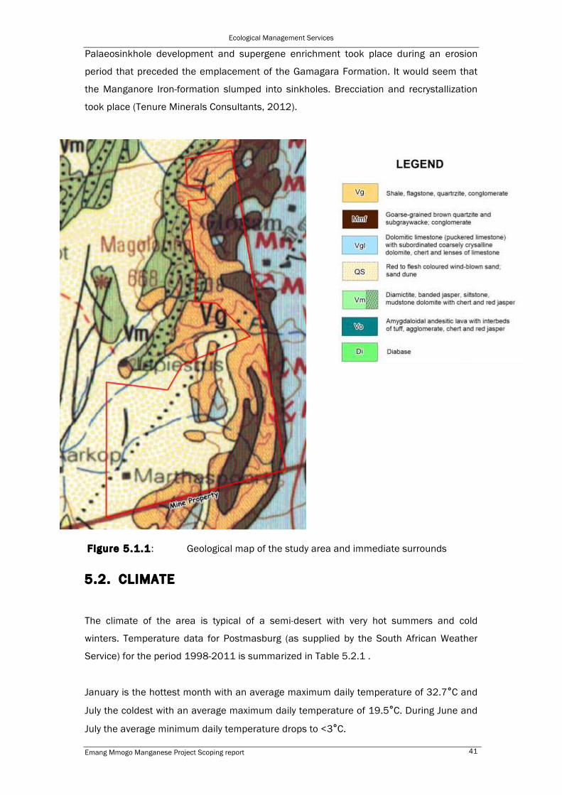
5.1. GEOLOGY
The Emang Project is located within the Maremane Dome in the Northern Cape Province
The Manganese deposits belong to the bixbyite rich Western Manganese Belt of the
Postmasburg Manganese Field. (Tenure Minerals Consultants, 2012)
The manganese deposits of the Postmasburg area are related to the unconformity
between the Campellrand Subgroup of the Ghaap Group and the Gamagara Formation of
the Maremane dome. It has also been commented that the Campbellrand dolomite
sequence and the Manganore Iron Formation of the Gjhaap group outcrop on the dome.
This is unconformably overlain by conglomerate or shale of the Gamagara formation.
Supergene bixbyite rich manganese deposits are developed in the Sishen shale member
of the Gamagara formation where the Gamagara formation rests on the manganiferrous
dolomite of the Reivilo Formation of the Campbellrand Subgroup.

Ecological Management Services
Emang Mmogo Manganese Project Scoping report 40
Figure 5.1: Locality map of the proposed mining development in relation to
Postmasburg.
The slumping of the manganese deposits took place in the sinkholes that formed in the
Campbellrand Subgroup dolomites during a period of erosion, before the deposition of
the Gamagara Formation. In the central part of the Maremane dome the palaeosinkholes
were filled with alumina-rich shale and manganese wad. Thrust faulting in the region has
caused that the Ongeluk lava of the Transvaal Supergroup is now overlying the Gamagara
Formation. (Tenure Minerals Consultants, 2012).
The manganese deposit at the Emang Mmogo Manganese Project is irregular in shape
due to the formation conditions, where the manganese deposit slumped into
palaeosinkholes. This caused topography of dolomite pinnacles with pockets of
manganese deposits. The most common manganese mineral present is bixbyite, which
also occurs in the recrystallized wad.
Proposed development site
Ecological Management Services
Emang Mmogo Manganese Project Scoping report 41
Palaeosinkhole development and supergene enrichment took place during an erosion
period that preceded the emplacement of the Gamagara Formation. It would seem that
the Manganore Iron-formation slumped into sinkholes. Brecciation and recrystallization
took place (Tenure Minerals Consultants, 2012).
F igure 5.1.1: Geological map of the study area and immediate surrounds
5.2. CLIMATE
The climate of the area is typical of a semi-desert with very hot summers and cold
winters. Temperature data for Postmasburg (as supplied by the South African Weather
Service) for the period 1998-2011 is summarized in Table 5.2.1 .
January is the hottest month with an average maximum daily temperature of 32.7°C and
July the coldest with an average maximum daily temperature of 19.5°C. During June and
July the average minimum daily temperature drops to <3°C.
- 14 -
GHT CONSULTING SCIENTISTS EMANG MMOGO JUNE 2013 – HYDROCENSUS RVN 670.1/1415
Figure 9. Emang Mmogo Mining Project – Geology Map
- 14 -
GHT CONSULTING SCIENTISTS EMANG MMOGO JUNE 2013 – HYDROCENSUS RVN 670.1/1415
Figure 9. Emang Mmogo Mining Project – Geology Map

Ecological Management Services
Emang Mmogo Manganese Project Scoping report 42
Month Ave Temp (0C) Max Temp (0C) Min Temp (0C) Ave Rain (mm)
Jan 23.7 32.7 16.1 40.8
Feb 22.8 31.7 16.1 79.1
Mar 21.3 30.3 14.6 29.3
Apr 17.0 26.4 11.0 22.0
May 11.9 22.2 5.5 9.3
Jun 8.9 20.0 2.3 5.2
Jul 8.4 19.5 1.3 1.1
Aug 11.3 22.3 3.5 3.2
Sep 15.7 26.5 7.0 7.8
Oct 19.7 29.7 10.9 17.9
Nov 21.7 31.4 12.9 15.0
Dec 23.8 33.3 15.5 23.6
Mean Annual Precipitation (mm)
Absolute min temp recorded (26/07/2004)
Absolute max temp recorded (22/12/2009)
254.3
-6.90
39.80
Table 5.2.1: Temperature data for Postmasburg (South African Weather Service)
The maximum temperature recorded during this period was 39.8 0C and the lowest
6.90C.
The study area falls within the summer rainfall area with a mean annual precipitation
(MAP) of 385.3 mm for the study area. The average monthly precipitation and standard
deviation (SD) values for Lomoteng Mine just to the north of the proposed mine, are
summarized in Table 5.2.2 below.
Average monthly precipitation for Lomoteng (Station Coordinates: S28o01' E023o01)
Mean (mm) SD (mm)
Jan 62.1 43.6
Feb 71.5 47.5
Mar 74.9 47.8
Apr 41.9 34.3
May 16.4 19.3
Jun 5.4 110

Ecological Management Services
Emang Mmogo Manganese Project Scoping report 43
Jul 3.9 8.8
Aug 5.5 10.6
Sep 10.8 15.2
Oct 20.1 21.1
Nov 29.7 26.1
Dec 43.1 33.9
Annual 385.3 104.6
Table 5.5.2: Precipitation statistics for Lomoteng (Source: South African Rain Atlas)
The table indicates that ~84% of the mean annual precipitation occurs during the months
November to April. This phenomenon is characteristic of a summer rainfall area. March is
the wettest month with an average precipitation of ~75 mm whilst July is the driest with
<4 mm.
5.3. TOPOGRAPHY, LAND TYPE AND SOIL
The topography is mountainous with a gentle slope down towards the west, varying
between approximately 1465 mamsl at the eastern boundary and 1507 mamsl at the
western, with a non-perennial stream at approx. 1408 mamsl between the two
topographic highs. The terrain is described as high open hills and ridges with an average
slope angle of between 6 – 8%.
The topography of the study area has already been disturbed by previous mining
activities. The study area was mined by Assmang Ltd in the 1960 to 1980’s. Assmang
did not undertake any rehabilitation on the site after they seized their operations, thus
there are pits and large stockpiles all over the study area.
The study area falls with the Ag & Ib, land types (ARC – Institute for Soil Climate & Water),
a land-type being an area that is uniform with respect to terrain form, soil patterns and
climate.
The soils within the Ag landtype are typically classified as EB soils, which are soils with
minimal development, usually shallow on hard or weathering rock, with or without
intermittent diverse soils. Lime is generally present in part or most of the landscape.
They are non-calcarious < 450 mm deep with < 15% clay content.

Ecological Management Services
Emang Mmogo Manganese Project Scoping report 44
The Ib landtype is a miscellaneous land class, and consists of miscellaneous soils and
rocks. The most common soils are Hutton and Mispah soil formations (soils with High
percentage rocks and bedrock-almost no A horizon) and are described as low potential
soils
Plate 5.3.1: The topography of the proposed development site on the western side.
Plate 5.3.2: The effects of previous mining activity on the topography of the proposed
development site.

Ecological Management Services
Emang Mmogo Manganese Project Scoping report 45
5.5. LAND CAPABILITY
The area is described as non-arable low potential grazing land. The grazing capacity is
between 16 -29 ha per LSU. Owing to the open pits and waste dumps currently on site
the area is considered mostly unsuitable for stock farming
5.6. LAND USE
5.6.1. Pre-project land use
Historical mining on the project area occurred from 1960 to the early 1980’s by
Associated Manganese (Assmang). Mining operations ceased when Assmang’s primary
area of operation moved to the Kalahari Manganese Field. Some of the abandoned pits
are being used as illegal dumping sites by surrounding landusers. Some prospecting
activity has recently taken place on site.
Plate 5.6.1: a) Dolomite intrusions visible from the previous mining activity, b) some of
the waste dumps present on the property, c) the area contains numerous pits and dumps
d) on of the pits being used as an illegal dumping site.
Photo Report
EMPh1 0312 v5.0 J.A. Upshall & T.J. Richards 31
TENURE MINERALS CONSULTANTS
Plate 11: Dolomite Pinnacles Exposed in Old Workings on Gloucester
Three dimensional structure diagrams and cross sections of the strata were developed and will be used to plan further exploration in detail. The 3D structure in the central area surrounding MPD10, MPD11 and MPD12 is shown in Figure 7 below. This highlights the many layers of manganiferrous material intersected and the complexity of the structural geology.
Figure 7: Central Area Ore Body Structure
a b
c d

Ecological Management Services
Emang Mmogo Manganese Project Scoping report 46
5.6.2. Exist ing structures
• The railway line from Sishen to Postmasburg is situated directly east of the
properties.
• The Ertsrand railway siding is approximately 2.2km southeast of the project area.
• The Gamagara water pipeline passes the study area west of the R325
• A gravel road links the study area to the main provincial road (R325)
• There are existing access roads within the study area.
• The mining village of Glosam is adjacent the project development site on the west
• Lohatla village is located to the north east of the study site
• Landing strips exist in both Postmasburg and Kathu
• There are several boreholes which were part of the exploration research. None of
these is however equipped for drinking water
• The northern boundary fence has diamond mess while the remainder of the
boundary fences consist of 1.2m eight string stock proof fencing.
• There are presently 2 camps on the farm but some of the internal fences are in
poor condition.
5.6.3. Surrounding landuse
Most of the area immediately surrounding the study area is also subject to mining
projects. The other landuse is extensive domestic stock farming. The following is the list
of mining operations that are currently being undertaken within the surrounding area.
Mine Ownership
Bishop PMG mining
Lomoteng Private
Lohatlha Chabua Minerals Limited
Driehoekspan Maremane Mining Limited
Glosam Assmang
Manganore Union Mines

Ecological Management Services
Emang Mmogo Manganese Project Scoping report 47
Figure 5.6.1: The location of other mining activities in the surrounding areas adjacent
to the proposed development site.
5.7. FLORA AND FAUNA
Vegetation Descript ion
The study area falls with three vegetation types, Kuruman Mountain Bushveld, Kuruman
Thornveld and Olifantshoek Plains Thornveld (Mucina & Rutherford 2006).
The Kuruman Mountain bushveld is described as occurring on rolling hills with gentle to
moderate slopes and hill pediments with an open shrubveld. The grass layer is generally
well developed and the shrub layer is dominated by Lebekia macrantha. Other important
taxa include, Rhus lancea, Euclea crispa, Rhus ciliata, Gomphocarpus fruticosus,
Emang Mmogo

Ecological Management Services
Emang Mmogo Manganese Project Scoping report 48
Anthephora pubescens, Digitaria eriantha, Eustachys paspaloides, Geigeria ornativa, and
Helichrysum cerastiodes.
The Kuruman Thornveld is typically found on flat rocky plains and some sloping hills. It
has a very well developed closed shrub layer and well developed open tree stratum.
Important taxa within this vegetation type includes, Acacia erioloba, Acacia mellifera,
Lycium hirsutum, Tarchonanthus camphoratus , Acacia hebeclada, Aristida meridionalis,
Eragrostis lehmanniana, Dicoma schinzii, Limeum fenestratum and Nolletia ciliaris.
The Olifantshoek Plains Thornveld is found on plains with an open tree and shrub layer,
formed by species such as Acacia luederitzii, Bosica albitrunca and Rhus tenuinervis.
The grass layer is usually sparse with species such as Schmidtia pappophoroides,
Stipagrostis uniplumis and Aristida congesta.
F igure 5.7.1: The vegetation map of the study area according to Mucina & Rutherford
(2006).
The area has been subjected to previous mining activity that was not rehabilitated and
consequently waste dumps and open pits cover much of the study area. Most of the
disturbed areas have been re-colonised by vegetation. Although bare patched of exposed
substrate are evident, there are many small trees and shrubs through the area. The
vegetation within the disturbed areas is however considered secondary in nature.
Kuruman Mountain bushveld
Kuruman Thornveld
Olifantshoek Plains Thornveld

Ecological Management Services
Emang Mmogo Manganese Project Scoping report 49
F igure 5.7.2: SPOT image of the study area.
Floral species of Conservation Concern
Historical records of Red List plant species were consulted in order to determine the
likelihood of any such species occurring in the study area. Lists of plant species
previously recorded in the quarter degree grids in which the study area is situated were
obtained from the South African National Biodiversity Institute. Hereroa wilmaniae
L.Bolus a perennial succulent has been recorded within the quarter degree square
2823AA in which the study area falls, this species is listed as data deficient (DDT). There
have been no other species recorded on site or in the quarter degree grid that appear on
the IUCN-Red Data List.
Protected tree species that may occur on the property could include, Acacia erioloba, and
Boscia albitrunca.
Faunal species of Conservation Concern
Protected faunal species found in habitat typical of the study area and surrounding areas
that could have the potential for occurrence on site would include:
Scientific name Common name Threatened Status
Pyxicephalus adspersus Giant Bullfrog NT

Ecological Management Services
Emang Mmogo Manganese Project Scoping report 50
Python natalensis Southern African Python VU
Atelerix frontalis South African Hedgehog NT
Cloeotis percivali Short-eared Trident Bat CR
Crocidura cyanea Reddish-grey Musk Shrew DD
Crocidura hirta Lesser Red Musk Shrew DD
Elephantulus brachyrhynchus
Short-snouted Elephant-shrew DD
Elephantulus intufi Bushveld Elephant-shrew DD
Hyaena brunnea Brown Hyaena NT
Laephotis botswanae Botswana Long-eared Bat VU
Lemniscomys rosalia Single-striped Mouse DD
Leptailurus serval Serval NT
Manis temminckii Pangolin VU
Mellivora capensis Honey Badger NT
Miniopterus schreibersii Schreiber's Long-fingered Bat NT
Pipistrellus rusticus Rusty Bat NT
Poecilogale albinucha African Weasel DD
Rhinolophus clivosus Geoffroy's Horseshoe Bat NT
Rhinolophus darlingi Darling's Horseshoe Bat NT

Ecological Management Services
Emang Mmogo Manganese Project Scoping report 51
Rhinolophus hildebrantii Hildebrant's Horseshoe Bat NT
Suncus lixus Greater Dwarf Shrew DD
Tatera leucogaster Bushveld Gerbil D
The Kori Bustard, Lappet-faced Vulture, White-backed Vulture, Martial Eagle, Tawny Eagle
and Secretary Bird are Red Listed Birds, which may occur in the area.
5.8. HYDROLOGY
5.8.1. SURFACE HYDROLOGY
The study area lies within Lower Vaal Water Management Area. Two sub-catchment have
been identified for the study area to determine the drainage of water across the area:
a) The Northern sub catchment and
b) Southern sub catchment.
The northern sub-catchment (indicated in green in Figure 5.8.1) lies within the Drainage
region D41J. The surface water drainage originates from the eastern and western
boundaries of the proposed mining area. The flow follows the topographic low to the non
perennial stream in the center of the study site and then flows north into the Dam
(identified as BP01 in Figure 5.8.1, which is located outside the mining area). Water from
this dam continues along the non-perennial stream towards the adjacent farms.
The southern sub catchment (indicated in blue in Figure 5.8.1) lies within the Drainage
region D73J. The surface water drainage from the eastern boundary across the study
area in a westerly direction. Water follows the topographic low from the eastern boundary
to the west from where it follows the non perennial stream located to the south west of
the mining area.
Surface water impoundments within the area have been identified as BP01 and BP02 in
Figure 5.8.1: Both of these are constructed sand dams that hold water when water flows
in the non-perennial water courses during periods of high rainfall.

Ecological Management Services
Emang Mmogo Manganese Project Scoping report 52
F igure 5.8.1: Surface catchment areas and drainage within and surrounding the study
area.
- 12 -
GHT CONSULTING SCIENTISTS EMANG MMOGO JUNE 2013 – HYDROCENSUS RVN 670.1/1415
Figure 8. Emang Mmogo Mining Project - Drainage sub catchment
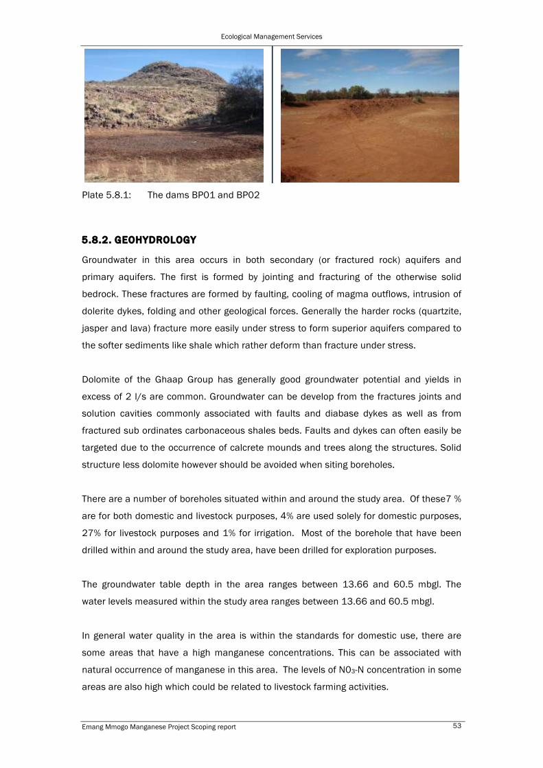
Ecological Management Services
Emang Mmogo Manganese Project Scoping report 53
Plate 5.8.1: The dams BP01 and BP02
5.8.2. GEOHYDROLOGY
Groundwater in this area occurs in both secondary (or fractured rock) aquifers and
primary aquifers. The first is formed by jointing and fracturing of the otherwise solid
bedrock. These fractures are formed by faulting, cooling of magma outflows, intrusion of
dolerite dykes, folding and other geological forces. Generally the harder rocks (quartzite,
jasper and lava) fracture more easily under stress to form superior aquifers compared to
the softer sediments like shale which rather deform than fracture under stress.
Dolomite of the Ghaap Group has generally good groundwater potential and yields in
excess of 2 l/s are common. Groundwater can be develop from the fractures joints and
solution cavities commonly associated with faults and diabase dykes as well as from
fractured sub ordinates carbonaceous shales beds. Faults and dykes can often easily be
targeted due to the occurrence of calcrete mounds and trees along the structures. Solid
structure less dolomite however should be avoided when siting boreholes.
There are a number of boreholes situated within and around the study area. Of these7 %
are for both domestic and livestock purposes, 4% are used solely for domestic purposes,
27% for livestock purposes and 1% for irrigation. Most of the borehole that have been
drilled within and around the study area, have been drilled for exploration purposes.
The groundwater table depth in the area ranges between 13.66 and 60.5 mbgl. The
water levels measured within the study area ranges between 13.66 and 60.5 mbgl.
In general water quality in the area is within the standards for domestic use, there are
some areas that have a high manganese concentrations. This can be associated with
natural occurrence of manganese in this area. The levels of N03-N concentration in some
areas are also high which could be related to livestock farming activities.
- 33 -
GHT CONSULTING SCIENTISTS EMANG MMOGO JUNE 2013 – HYDROCENSUS RVN 670.1/1415
Photo 62. BP01 Photo 63. BP02

Ecological Management Services
Emang Mmogo Manganese Project Scoping report 54
F igure 5.8.2: Location of boreholes with and around the study area
5.9. SITES OF ARCHAEOLOGICAL AND CULTURAL INTEREST
In terms of section 38 of the National Heritage Resources Act, 1999, (Act No. 25 of
1999), a Phase 1 Archaeological Impact Assessment was undertaken by David Morris
from the McGregor Museum for the property prior to the commencement of prospecting
activity, in 2008. A summary of this report is given below.
The study was undertaken in order to establish if any localities of heritage significance
were present on the property.
None of the observed sites proved in themselves to be of major significance, but
collectively they provide insight into the Stone Age occupation of the area.
- 24 -
GHT CONSULTING SCIENTISTS EMANG MMOGO JUNE 2013 – HYDROCENSUS RVN 670.1/1415
Figure 13. Map groundwater usage
- 24 -
GHT CONSULTING SCIENTISTS EMANG MMOGO JUNE 2013 – HYDROCENSUS RVN 670.1/1415
Figure 13. Map groundwater usage

Ecological Management Services
Emang Mmogo Manganese Project Scoping report 55
No post-Stone Age/colonial era heritage traces were noted in the area examined and the
farmer Mr Arrie Claasens, who grew up on the farm, knew of no such sites or features
within the Portions 4 and 5 of Magoloring.
No heritage traces of the nineteenth-twentieth century were noted. The farmer, Mr
Claasens, who has known the farm for more than half a century (he indicated that he had
grown up there and as a boy hunted baboons in the hills), said that he knew of no graves
of any nature in the valley.
5.10. AIR QUALITY
Identification of existing sources of emissions in the region and the characterisation of
existing ambient pollution concentrations is fundamental to the assessment of
cumulative air impacts. A change in ambient air quality can result in a range of impacts,
which in turn, may cause a disturbance to nearby receptors.
Ambient air pollutant concentrations within the Postmasburg region occur not only due to
local sources but also as a result of emissions from various remote sources. The most
significant of these sources located within the region include:
• fugitive dust emissions from mining, tailings impoundments and mineral
processing operations, which are associated with manganese and iron mining
operations;
• vehicle tailpipe emissions-significant primary pollutants emitted by motor vehicles
include CO2, CO, hydrocarbons (HCs), NOx, SO2, particulate matter and lead;
• vehicle entrained dust from paved and unpaved roads;
• household fuel combustion by means of coal and wood;
• biomass and veld burning; and
• various miscellaneous fugitive dust sources, including: agricultural activities and
wind erosion of open areas.
5.11. NOISE
Some of the noise generating activities associated with the project may cause an
increase in ambient noise levels in and around the site. This may cause a disturbance to
nearby receptors. As a baseline, this section provides a brief description of pre-mining
conditions in the area from which to measure changes as a result of project-related
noise.

Ecological Management Services
Emang Mmogo Manganese Project Scoping report 56
The proposed project site is located in a rural-type area characterised by farms and
associated scattered residences with traffic on the R325 road (located approximately
5km from the proposed mining area). Accordingly, the ambient noise climate is expected
to exhibit noise levels as defined in South African national Standards (SANS) 10103 for
rural areas. In this regard, noise levels are expected to be 40dBA and 35dBA for day-time
and night-time levels respectively.
It should however be noted that levels of noise generated by specific distant sources,
such as mines and roads, vary by a considerable margin with changes in wind direction
and temperature profiles in the lower atmosphere.
5.12. VISUAL ASPECTS
Project-related activities have the potential to alter the landscape character of the site
and surrounding area through the establishment of both temporary and permanent
infrastructure. As a baseline, this section provides an understanding of the pre-mining
visual character of the project area against which to measure potential change as a result
of project infrastructure and activities.
The project area lies in an undulating Mountainous terrain. The area has been subjected
to previous mining activity that was not rehabilitated and consequently waste dumps and
open pit abound the study area. Most of the study area has been re-colonised by
vegetation so although bare patched of exposed substrate are evident, there are many
small trees and shrubs through the area.
Central to the visual character of an area are the concepts of sense of place and scenic
quality. Sense of place is informed by the spatial form and character of the natural
landscape taken together with the cultural transformations and traditions associated with
the historic use and habitation of the area which lend that area its uniqueness and
distinctiveness. The scenic quality of the project site and surrounding area is linked to the
type of landscapes that occur within an area. In this regard scenic quality can range from
high to low as follows:
• High – these include the natural features such as mountains and koppies and
drainage systems.
• Moderate – these include agricultural activities, smallholdings, and recreational
areas.
• Low – these include towns, communities, roads, railway line, industries and
existing mines.

Ecological Management Services
Emang Mmogo Manganese Project Scoping report 57
Numerous mining related activities exist in the area to the south and north of the project
area. The undulating nature of the terrain within the proposed mining area however
limits the extent of visual intrusions. The area has already been disturbed by previous
mining activity the result is a landscape with a fairly poor sense of place and a moderate
to low scenic quality.
5.10. REGIONAL SOCIO-ECONOMIC STRUCTURE/PROFILE
Magisterial Distr ict and Local Authorit ies
The study area falls within the Tsantsabane Municipality in the Siyanda District in the
Northern Cape. The Northern Cape has five municipal districts, namely Frances Baard,
Siyanda, Namaqua, Kgalagati and Pixely Ke Seme.
Siyanda District Municipality (SDM) forms the mid-northern section of the province on the
frontier with Botswana. It covers an area of more than 100,000 square kilometers
(almost 30% of the entire Province) out of which 65, 000 square kilometers compromise
the vast Kalahari Desert, Kgalagadi Transfrontier Park and the former Bushman Land.
Siyanda District comprises six Local Municipalities namely: Mire; Kai! Garb; Kara Hais;
Tsantsabane, !Kheis and Kgatelopele. Upington is the district municipal capital where the
municipal government is located. The whole area is managed by the Siyanda District
Municipality, which is classified as a category C Municipality.
The Census report of 2001 showed a population of 202 160 and 238 063 in the 2007
Community Survey. (Census, 2001; Community Survey, 2007)
Municipality Census 2001
Community survey 2007
% of the total population
Difference Area (Km2)
Persons/ km2
Mier 6844 7337 3% 499 22468 0.3
Kai Gariep 55702 56501 24% 793 26357 2.1
//Khara Hais 75671 100920 42% 25249 21780 4.6
!Kheis 16123 18920 8% 2797 11107 1.7
Tsantsabane 23987 28005 12% 4018 18330 1.5
Kgatelopele 14743 21498 9% 6755 2478 8.7
DMA 9090 4882 2% -4208
Total 202160 238063 100% 35903 102520 2.3
Table 5.10.1: Population survey of the Siyanda District

Ecological Management Services
Emang Mmogo Manganese Project Scoping report 58
The above table recorded an increase of 35 903 people that represents a 17, 8%
increase in overall population when comparing the 2001 Census and 2007 Community
Survey. Note the DMA has since been incorporated into the neighboring municipalities.
The aforementioned table shows that the majority of the population is located in the
//Khara Hais Municipality (42%), followed by the Kai! Garib Municipality (24%) and the
Tsantsabane Municipality (12%). The Main settlements in the aforementioned
municipalities are: Upington, Keimoes; and Postmasburg, respectively.
There are five hospitals in the SDM. There are only two Community Health Facilities in the
SDM. There are 52 clinics in the SDM the clinics are generally located in settlements
along the main routes through the municipality, namely the N14 and the N10. It should
be noted that medical staff are not stationed at all these facilities on a full time basis and
in some cases the staff are on site only once a month. (IDP, 2007-2011)
Tuberculosis and HIV/AIDS are some of the infectious diseases that are receiving priority
attention and that a shortage of staff hampers the delivery of health services in the SDM.
In this region the greatest social problems are considered to be illiteracy and poverty.
According to the last socio-economic survey in 2000, approximately 60% of the
inhabitants have a monthly household income of between R0 – R800. Poor health is
often associated with factors such as malnutrition especially among the children. The
malnutrition is often attributed to insufficient funds to acquire adequate food.
Malnutrition of children can also be attributed to the lack of education of parents who
provide for the children. Adult literacy in the area is considered to be below standard.
Siyanda District Municipality accounts for about 30% of the Northern Cape economy.
Siyanda's economy is largely dominated by mining and agriculture
The proposed mining development falls within the Tsantsabane local municipality. The
extent of the geographical area of the municipality is 5 887km2.
The major routes running through Postmasburg include the R385 from Kimberley that
runs through Beeshoek, the R309 and the R325 to Kathu. Tsantsabane Municipality is
characterized by a mixture of land uses of which agriculture and mining is dominant land
use within the rural areas. The residential areas vary from the relatively large town of
Postmasburg to small scattered rural communities. Some of these communities are the
remains of railway stations.

Ecological Management Services
Emang Mmogo Manganese Project Scoping report 59
According to Statistics SA Census Data (2001) 47.6% of the population of Tsantsabane
Municipality is male and 52.3% is female. Approximately 31% of the population is under
14 years and ±33% is between 15 and 34 years.
The statistics show that approximately 17% of the population is illiterate. The median
qualification is, between Grade 7 and Grade 9, which means that a large part of the
population can perform unskilled or semi-unskilled work. Less than 15% of the
population has a tertiary qualification or have completed Grade 12.
According to Statistics SA Census Data (2001) 41% of the total labour force in the area is
unemployed. This statistic indicates that there is a low level of skills development and
hence the serious need which exists for adult education and in-service training
programmes.
Industry Persons (2001)
Agriculture/Forestry/Fishing 513
Community/Social/Personal 1592
Construction 349
Electricity/Gas/Water 23
Financial/Insurance/Real
Estate/Business
357
Manufacturing 469
Mining/Quarrying 714
Other 0
Private Households 782
Transport/Storage/Communication 213
Undetermined 477
Wholesale/Retail 845
The most important employer in the Municipal Area is the mining sector

Ecological Management Services
Emang Mmogo Manganese Project Scoping report 60
6. ISSUES AND CONCERNS
Typically a development of this nature is divided into the construction phase, operational
phase, decommissioning phase and closure phase.
6.1. POTENTIAL BIOPHYSICAL ENVIRONMENTAL IMPACTS
6.1.1. GEOLOGY
Issue: Loss and steri l isat ion of mineral resources
Project phase/s in which impact could occur
Construction Operational Decommissioning Closure
x x x x
Discussion:
By the nature of mining projects the geology is exploited for target minerals therefore
there will be an impact on the geology, however it is important to note that owing to the
previous mining activity there are already pre-existing impacts. It is also important that no
future resources become sterilised either through the mine design or through the
disposal of mineralised waste.
6.1.2. TOPOGRAPHY
Issue: Hazardous excavations and infrastructure
Project phase/s in which impact could occur
Construction Operational Decommissioning Closure
x x x x
Discussion:
Hazardous excavations and infrastructure include all structures into or off which third
parties and animals can fall and be harmed. The proposed project may have the potential
to alter the topography through the introduction of new infrastructure which may present
safety risks. Hazardous excavations and infrastructure occur in all mine phases from
construction through operation to decommissioning and closure. However it is important
to note that owing to the previous mining activity and lack of rehabilitation there are
already pre-existing impacts
6.1.3: SOIL AND LAND CAPABILITY
Issue: Loss of soi l and change in land capabil i ty through pol lut ion, erosion
or compaction
Project phase/s in which impacts could occur

Ecological Management Services
Emang Mmogo Manganese Project Scoping report 61
Construction Operational Decommissioning Closure
x x x x
Discussion:
Topsoil is generally a resource of high value containing a gene bank of seeds of
indigenous species. The proposed project will result in disturbance of the land surface
and associated topsoil in all project phases. A loss of topsoil (through pollution, erosion or
compaction) would generally result in a decrease in the rehabilitation and future land use
capability of any land that is disturbed by the project. There has already been a
significance disturbance to the area. Top soil has been lost from the old mining areas.
6.1.4. FAUNA AND FLORA (NATURAL PLANT AND ANIMAL LIFE)
Issue: Loss of natural vegetation and animal l i fe
Project phase/s in which impact could occur
Construction Operational Decommissioning Closure
x x x x
Discussion:
The proposed projects will require the clearing of land and habitat for the establishment
of infrastructure and this has the potential to impact negatively on plant and animal life in
the project sites and adjacent areas. Although much of the vegetation is considered
secondary in nature, owing to historical mining, the loss of the vegetation will result in the
loss of the habitat for the faunal populations that have re-colonised.
6.1.5. HYDROLOGY (SURFACE WATER)
Issue: Alteration of surface drainage patterns
Project phase/s in which impact could occur
Construction Operational Decommissioning Closure
x x x x
Discussion:
The proposed project site is located within the vicinity of an ephemeral water course. The
diversion of clean water and the retention of water in dirty areas has the potential to
impact on drainage patterns.
The alteration of drainage patterns may also result in secondary impacts on fauna and
flora, either through the direct disturbance of habitat and individuals or by the reduction
of the availability of water to sustain plant and animal life.

Ecological Management Services
Emang Mmogo Manganese Project Scoping report 62
Issue: Contamination of surface water
Project phase/s in which impact could occur
Construction Operational Decommissioning Closure
x x x x
Discussion:
Projects of this nature will generally present a number of pollution sources that can have
a negative impact on surface water quality throughout the duration of the projects. The
potential pollution sources associated with the proposed projects include: sewage, fuel,
lubricants, non-mineralised waste, (hazardous and general), run-off from the mineralised
waste and erosion of particles from exposed soils in the form of suspended solids.
6.1.6. GROUNDWATER
Issue: Reducing groundwater levels and avai labi l i ty
Project phase/s in which impact could occur
Construction Operational Decommissioning Closure
x x x x
Discussion:
Groundwater levels could be reduced in the project area by dewatering activities to
ensure safe mining conditions. This impact could be significant given the use of
groundwater by surrounding residents and farming activities.
Issue: Contamination of groundwater
Project phase/s in which impact could occur
Construction Operational Decommissioning Closure
x x x x
Discussion:
Projects of this nature will generally present a number of pollution sources that can have
a negative impact on groundwater quality throughout the duration of the projects. The
potential pollution sources associated with the proposed projects include: ad-hoc spills,
sewage, fuel, lubricants, non-mineralised waste (hazardous and general) and run-
off/seepage from the mineralised waste facilities
6.1.7. AIR QUALITY
Issue: Pol lut ion from emissions to air
Project phase/s in which impact could occur
Construction Operational Decommissioning Closure

Ecological Management Services
Emang Mmogo Manganese Project Scoping report 63
x x x
Discussion:
The proposed project has the potential to present a number of pollution sources that can
have a negative impact on air quality if unmanaged. Typically, the following pollution
sources may exist: dust clouds from initial surface blasting, wind erosion from exposed
surfaces, vehicle tail-pipe emissions and fugitive dust from un-surfaced roads
6.1.8. NOISE
Issue: Increase in disturbing noise levels
Project phase/s in which impact could occur
Construction Operational Decommissioning Closure
x x x
Discussion:
Site clearing activities, vehicle movements and blasting on site have the potential to
increase the ambient noise levels in the immediate vicinity of the proposed project sites
during the construction phase. During the operational phase general mining activities and
processing activities will also increase ambient noise levels during the operational phase.
Limited noise is expected post closure
6.1.9. VISUAL ASPECTS
Issue: Negative visual impacts
Project phase/s in which impact could occur
Construction Operational Decommissioning Closure
x x x X
Discussion:
The mine will alter the visual character of the project area. The proposed project area is
situated in a remote setting. There are some private landowners’ located whose
properties may overlook the proposed site and from whose properties the proposed
project areas are/could be visible. Although the area has been previously disturbed the
areas does contain a good vegetation covering and even though the area has not been
leveled the existing vegetation does mask the disturbance to some degree. It is proposed
that no further specialist investigations are required. The assessment and detailed
management measures will be provided in the EIA/EMPr

Ecological Management Services
Emang Mmogo Manganese Project Scoping report 64
6.2. POTENTIAL HERITAGE ENVIRONMENT IMPACTS
6.2.1. PALEONTOLOGICAL, ARCHAEOLOGICAL, HERITAGE AND CULTURAL
RESOURCES
Loss of or damage to paleontological, archaeological, heritage and cultural
resources
Project phase/s in which impact could occur
Construction Operational Decommissioning Closure
x x x X
Discussion:
Paleontological, archaeological, heritage and cultural resources of varying significance
are expected to occur in and around the project area. It is possible that the project could
impact some of these resources.
6.3. POTENTIAL SOCIO-ECONOMIC ENVIRONMENT IMPACTS
A list and description of potential impacts identified on the socio-economic conditions of
any person on the property, and on any adjacent or non-adjacent property which may be
affected by the proposed mining operation, is provided below
6.3.1. LAND USE
Impact on exist ing surrounding agricultural and residential uses
Project phase/s in which impact could occur
Construction Operational Decommissioning Closure
x x x X
Discussion:
The current land use of some of the project site will be changed during the construction,
operational and decommissioning phases of the proposed project. Areas within the
mining property is used for grazing and the proposed development may prevent access to
this grazing land for the operational, decommissioning and closure phases. At this stage
it is anticipated that some of the proposed surface infrastructure areas will be returned to
their current land use after mine closure, however some infrastructure such as the
proposed tailings facility and waste rock dumps may remain in perpetuity.
In addition, adjacent land uses, such as wilderness/conservation, residential and grazing
could potentially be affected by one or more impacts associated with the mining
activities. Associated issues may include disruption to surrounding land uses, changed
quality of life for surrounding residential areas and potential for change in property
values.

Ecological Management Services
Emang Mmogo Manganese Project Scoping report 65
6.3.2. TRANSPORT SYSTEMS
Issue: Disturbance of roads by project-related traff ic
Project phase/s in which impact could occur
Construction Operational Decommissioning Closure
x x x
Discussion:
The proposed Emang Mmogo mine will be accessed via a gravel road off the R325 road.
It is considered likely that additional traffic on this local road network will be generated
during the construction phase by vehicles transporting construction workers and
construction materials to and from the site. Similar levels of traffic are likely to be
expected during the decommissioning phase.
During the operational phase, transportation will be required for workers, consumables
and product. This will result in more traffic than any other project phase. The increase in
traffic on local roads during the construction, operation and decommissioning phase of
the proposed project may result in service level and safety impacts on the public road
network, as well as road users.
6.3.3. BLASTING
Issue: damage from blasting
Project phase/s in which impact could occur
Construction Operational Decommissioning Closure
x
Discussion:
Blasting impacts relating to the proposed project are associated with three pathways: fly
rock, vibrations and air blast. Fly rock can harm structures, people and livestock.
Vibrations and air blast can damage structures. It is relevant to note that once surface
blasting is complete (for the initial shaft development), the potential for fly rock and air
blast related impacts is eliminated and vibration impacts are reduced the deeper
underground blasting occurs.
The focus of the blasting assessment will be on cattle, cattle minders, residences and
road users.
6.3.4. ECONOMIC IMPACTS
Issue: Job creation and impact on local & regional economy
Project phase/s in which impact could occur

Ecological Management Services
Emang Mmogo Manganese Project Scoping report 66
Construction Operational Decommissioning Closure
x x x x
Discussion:
The project will result in positive economic benefits through wages, taxes, procurement
and foreign exchange income. In the case of wage related employment the impact of
creating temporary construction and operational jobs will be magnified through the
multiplier effect of increased spending power in local and regional economies. During the
decommissioning phase it is anticipated that temporary jobs will also be created,
however the number of jobs is not known at this stage. At closure of the relevant mine
sections, there may still be some positive impacts through maintenance and aftercare
activities and the fact that the mine would have contributed to a greater economic critical
mass, skills, and wealth that can be used in other economic opportunities.
There is potential for negative economic impacts after the operational phase when
employment is reduced.
6.3.4. SOCIAL IMPACTS
Issue: Inf lux of people and increased pressure on service infrastructure
Project phase/s in which impact could occur
Construction Operational Decommissioning Closure
x x x
Discussion:
There is potential for the following impacts to occur during the construction, operational
and decommissioning phases:
• influx of people into the area in search of work, leading to informal settlements
and associated problems of crime, disease, and social disruption; and
• increased pressure on housing and related services (water, power, sanitation,
rubbish removal, schooling);
6.4. POTENTIAL CUMULATIVE IMPACTS
Potential cumulative impacts are those for which the incremental changes associated
with the proposed projects will cumulatively add to existing environment which may
already be experiencing impacts. In this regard, the following are considered cumulative
impacts
• fauna and flora – loss of natural vegetation and animal life (only temporarily);
• surface water – alteration of surface drainage patterns or contamination of
surface water;

Ecological Management Services
Emang Mmogo Manganese Project Scoping report 67
• groundwater – reduction of groundwater levels and availability or contamination
of groundwater;
• air quality - pollution from emissions to air;
• noise – increase in disturbing noise levels;
• visual – negative visual aspects;
• socio-economic impacts;
• traffic and road impacts; and
• Land use impacts.

Ecological Management Services
Emang Mmogo Manganese Project Scoping report 68
7. PLAN OF STUDY FOR THE EIA
7.1. INTRODUCTION
It is important in terms of national policy and current legislation (The Mineral and
Petroleum Resources Development Act, the National Environmental Management Act
107 of 1998 (NEMA), the National Water Act 36 of 1998 (NWA), etc) to ensure that the
proposed development will uphold the principles of sustainable development and that the
principle of Integrated Environmental Management (IEM) will apply to the project design
and planning as well as throughout the duration of the proposed project.
7.2. ENVIRONMENTAL IMPACT ASSESSMENT
The overall objectives of the EIA will be as follows:
• Further investigate the receiving environment by means of specialist studies.
• Identify additional stakeholders and inform currently registered Interested and
Affected Parties (I&APs) about the proposed development, to make available to
them all the information that they will require in order to actively participate in the
process and to provide all I&APs with the opportunity to exchange information
and express concerns and views.
• To compile an issues trail for inclusion in the environmental impact assessment
report of the concerns and questions raised by the I&APs
• Undertake a site inspection and comprehensive literature review for the area to
further the identification of the potential positive and negative environmental
(both biophysical and social) impacts and evaluate their significance, in order to
describe how the environment may be affected by the proposed project.
• To identify and evaluate any viable alternatives for the proposed project.
• To comprehensively assess all identified issues in terms of negative and positive
impacts on both the biophysical and socio-economic environment.
7.2.1. LITERATURE REVIEW
A comprehensive literature review for the area in terms of the biophysical and social
environment was undertaken for the ESS. This included a review of the legislation &
regulations pertaining to the proposed development and it will be included in the EIA as
well as any additional information obtained during the course of the study.

Ecological Management Services
Emang Mmogo Manganese Project Scoping report 69
7.2.2. SPECIALIST STUDIES
The environmental scoping study revealed that additional and more in-depth
investigations were required for some aspects of the project in order to comprehensively
assess the impact the proposed development may have on these aspects of the
environment. The required specialist studies will be undertaken by suitably qualified
professionals. The specialist studies required as part of this EIA are described below:
Hydrocensus:
• Determine climatic data (including mean monthly and annual rainfall for the site
and number of days per month with measurable precipitation, mean monthly,
maximum and minimum temperatures, mean monthly evaporation);
• Develop a baseline hydrological description of the site and immediate surrounds;
• Determine flood peaks and volumes;
• Have input into the identification and assessment of the potential surface water
impacts; and
• Provide input, together the technical project team, into surface water
management measures going forward.
Geohydrological study:
A detailed investigation will be undertaken to address potential impacts on groundwater
resources. The investigation will include the following tasks:
• characterise the baseline geohydrological environment;
• model the dewatering impacts of the proposed mine;
• model the potential pollution dispersion associated with the mine and associated
infrastructure;
• assess the significance of dewatering and contamination impacts; and
• provide input, together with technical project team into project alternatives and
groundwater management measures going forward.
• Identify local groundwater users and determine their dependence on the
groundwater resource;
• Determine the pre-project (baseline) groundwater quality;
Noise impact studies:
Use will be made of the findings from previous noise studies done for similar mining
operations in the area to:
• qualify existing ambient noise conditions;

Ecological Management Services
Emang Mmogo Manganese Project Scoping report 70
• assess the impact of the project on the existing environment;
• have input together with Emang Mmogo into management and mitigation
measures.
Blasting and vibration studies:
A blasting specialist investigation will be undertaken to
• To outline the expected environmental effects that blasting operations could have
on the surrounding environment.
• To investigate the effect of blasting operations and the related influences with
regard to expected ground vibration, air blast, fly rock, and noxious fumes in
relation to the surroundings of the blast site and possible influence on the
neighbouring houses and owners or occupants
• To assess the impact on surrounding structures, people and animals.
• Recommend appropriate measures to mitigate blasting impacts
Heritage, cultural and archaeological studies:
• Determine whether there are any cultural or heritage resources on the surface as
defined in the NHRA.
• Assess the impact of the proposed project on any such resources; and
• Recommend appropriate mitigation measures.
Traff ic impact studies:
• To assess the existing levels of the traffic on the R325
• The identification of possible impacts of the proposed development on the road
network
• Assessment of the capacity of the existing and future road network within the
influence radius
• The road upgrading measures required to accommodate the proposed
development
• To assess the impact of haul trucks and delivery trucks on the existing traffic
Air qual ity studies:
• Identification of existing sources of emissions in the region and the
characterisation of existing ambient pollution concentrations.
• To assess the ambient air quality that may result in a range of impacts, which in
turn, may cause a disturbance to nearby receptors

Ecological Management Services
Emang Mmogo Manganese Project Scoping report 71
• Determine the key aspects of air pollution that may result from the construction,
operation and decommissioning phases of the project and model the impact from
these emission sources
• Outlining possible management and mitigation measures which could be
implemented at the Site to manage any potential impacts
Social & Economic Impact Assessment
Conduct an economic and sustainability analysis. The investigation will include the
following tasks:
• quantification of the economic impacts of the project;
• comparative land economic value-add assessment; and
• sustainability analysis.
• understand the baseline social environment, including a baseline review of
people residing adjacent to the proposed project;
• identify and assess both positive and negative social impacts; and
• have input together into management and mitigation measures
Biodiversity Assessment Study
Conduct a detailed ecological investigation to:
• identify and map different habitats in the proposed project area;
• review of distribution lists (including Red Data species) of fauna and flora species
to provide reference data against which the findings of the field surveys can be
compared;
• survey the areas that are required for surface infrastructure; assign species to
each habitat through various trapping and sampling methods;
• verify whether any Red Data species or any other sensitive species identified are
located within the proposed project area. The locality of any identified sensitive
species must be recorded and mapped;
• rank each habitat type based on conservation importance (in terms of provincial
biodiversity priorities) and ecological sensitivity;
• identify potential impacts on ecology;
• have input into management and mitigation measures.
7.2.3. ALTERNATIVES
In terms of the EIA Regulations, feasible alternatives are required to be considered. A
number of alternatives have been presented in the ESS, and some of these alternatives
appeared from initial assessments not to be feasible and therefore it is recommended

Ecological Management Services
Emang Mmogo Manganese Project Scoping report 72
that these alternatives are not carried forward to the EIA phase for further investigation.
Should the review of the scoping report reveal additional alternatives that may be
considered, these will be investigated during the EIA phase of the study. Information on
alternatives will be presented in the EIA phase.
7.2.4. IDENTIFICATION OF ISSUES
A number of issues were identified during the scoping process. These issues will be
assessed in the EIA.
7.2.5. EVALUATION OF ISSUES
To assess and quantify the identified impacts, six standard rating scales were identified
and used in this study. This is necessary since impacts have a number of parameters that
need to be assessed. The rating system used for assessing issues is based on three
criteria, namely:
1) The relat ionship of the issue to temporal scales;
The temporal scale defines the significance of the impact at various time scales, as an
indication of the duration of the impact
2) The relat ionship of the issue to spatial scales;
The spatial scale defines the physical extent of the impact.
3) The severity of the issue.
The severity/beneficial scale is used in order to scientifically evaluate how severe
negative impacts would be, or how beneficial positive impacts would be on a particular
affected system (for ecological impacts) or a particular affected party. It is a methodology
that attempts to remove any value judgements from the assessment, although it relies on
the professional judgement of the specialist.
The severity of impacts can be evaluated with and without mitigation in order to
demonstrate how serious the impact is when nothing is done about it. The word
‘mitigation’ means not just ‘compensation’, but also the ideas of containment and
remedy. For beneficial impacts, optimization means anything that can enhance the
benefits. However, mitigation or optimization must be practical, technically feasible and
economically viable.

Ecological Management Services
Emang Mmogo Manganese Project Scoping report 73
These three criteria are combined to describe the overall importance rating, namely the
significance. In addition, the following parameters are used to describe the issues:
4) The r isk or l ikel ihood of the issue occurr ing
The risk or likelihood of impacts taking place as a result of project actions differs between
potential impacts. There is no doubt that some impacts would occur, but other impacts are
not as likely to occur, and may or may not result from the proposed development. Although
some impacts may be severe, the likelihood of them occurring may affect their overall
significance. The probability of occurrence will therefore be taken into account.
5) The degree of confidence placed in the assessment of the issue.
It is also necessary to state the degree of certainty or confidence with which one has
predicted the significance of an impact. For this reason, a ‘degree of certainty’ scale has
been provided to enable the reader to ascertain how certain the assessment is of the
significance:
Each criterion is ranked with scores assigned as presented in Table 1 to determine the
overall significance of an activity. The criterion is then considered in two categories, viz.
effect of the activity and the likelihood of the impact. The total scores recorded for the
effect and likelihood are then read off the matrix presented in Table 2, to determine the
overall significance of the impact.

Ecological Management Services
Emang Mmogo Manganese Project Scoping report 74
Temporal scale Short term less than 5 years 1 Medium term between 5 and 20 years 2 Long term between 20 and 40 years (a generation) and from a human
perspective almost permanent. 3
Permanent over 40 years and resulting in a permanent and lasting change that will always be there
4
Spatial Scale Localised At localised scale and a few hectares in extent 1 Study area The proposed site and its immediate environs 2 Regional District and Provincial level 3 National Country 4 International Internationally 5 Severity * Slight Medium or short term impacts on the affected system(s) or
party(ies). Mitigation is very easy, cheap, less time consuming or not necessary.
1
Moderate Medium to long term impacts on the affected system(s) or party (ies), that could be mitigated.
2
Severe Long term impacts on the affected system(s) or party(ies) that could be mitigated. However, this mitigation would be difficult, expensive or time consuming or some combination of these
3
Very Severe An irreversible and permanent change to the affected system(s) or party (ies) which cannot be mitigated. For example the permanent loss of land
4
Risk or likelihood Unlikely the risk of these impacts occurring is slight 1 May occur the risk of these impacts is more likely, although it is not definite 2 Definitely occur
there is no chance that this impact will not occur 3
Degree of confidence Unsure Less than 40% sure of a particular fact or of the likelihood of an
impact occurring 1
Possible Only over 40% sure of a particular fact or of the likelihood of an impact occurring
2
Probable Over 70% sure of a particular fact, or of the likelihood of that impact occurring
3
Definite More than 90% sure of a particular fact. To use this, one will need to have substantial supportive data
4
* In certain cases it may not be possible to determine the severity of an impact thus it may be determined: Don’t
know/Can’t know Table.1: Ranking of evaluation Criteria
3 4 5 6 7 8 9 10 11 12 13 2 5 6 7 8 9 10 11 12 13 14 15 3 6 7 8 9 10 11 12 13 14 15 16 4 7 8 9 10 11 12 13 14 15 16 17 5 8 9 10 11 12 13 14 15 16 17 18 6 9 10 11 12 13 14 15 16 17 18 19
7 10 11 12 13 14 15 16 17 18 19 20
Table .2: Significance ranking matrix

Ecological Management Services
Emang Mmogo Manganese Project Scoping report 75
The method of evaluating positive impacts follows on the same principles as the negative
impacts, with the same criterion being used. However, the definitions of categories differ,
indicating positive impacts rather than negative ones. For example,
Severity Slight beneficial
A short to medium term impact and negligible benefit to the affected system(s) or party(ies). Other ways of optimising the beneficial effects are easier, cheaper and quicker, or some combination of these
1
Moderate beneficial
A medium- to long term impact of real benefit to the affected system(s) or party(ies). Other ways of optimising the beneficial effects are equally difficult, expensive and time consuming (or some combination of these), as achieving them in this way.
2
Beneficial A long term impact and substantial benefit to the affected system(s) or party(ies). Alternative ways of achieving this benefit would be difficult, expensive or time consuming, or some combination of these
3
Very beneficial
A permanent and very substantial benefit to the affected system(s) or party(ies), with no real alternative to achieving this benefit.
4
The significance of impacts are determined based on the evaluation of an activity’s
impact in terms of; intensity, extent, duration, nature, probability, and frequency. Using
the sum of the evaluation ranking within Table 1 and the matrix in Table 2, overall
significance can be classified as follows:
Significance LOW These impacts will usually result in medium to short term effects on the
social and/or natural environment. Impacts rated as LOW will need to be considered by the public and/or the specialist as constituting a fairly unimportant and usually short term change to the (natural and/or social) environment. These impacts are not substantial and are likely to have little real effect.
5-10
MEDIUM These impacts will usually result in medium to long term effects on the social and/or natural environment. Impacts rated as MODERATE will need to be considered by society as constituting a fairly important and usually medium term change to the (natural and/or social) environment. These impacts are real but not substantial
11-14
HIGH These impacts would be considered by society as constituting a major and usually long term to permanent change to the (natural and/or social) environment, and usually result in severe or very severe effects, or beneficial or very beneficial effects. Society would probably view these impacts in a serious light.
15-20
The environmental significance scale is an attempt to evaluate the importance of a
particular impact. This evaluation needs to be undertaken in the relevant context, as an
impact can either be ecological or social, or both. The evaluation of the significance of an
impact relies heavily on the values of the person making the judgement. For this reason,
impacts of especially a social nature need to reflect the values of the affected society.
In many cases scientists have to produce an assessment in the absence of all the relevant
and necessary data. Under these circumstances the consultant must make clear that such

Ecological Management Services
Emang Mmogo Manganese Project Scoping report 76
information is lacking if the incomplete information is essential to a reasoned choice among
alternatives. If the overall costs of obtaining it are not exorbitant, then the information
should be included in the EIA.
There are two acceptable procedures to follow to compensate for a shortage of data:
1. I t is more important to identify l ikely environmental impacts than to
precisely evaluate the more obvious impacts
All assessors try to evaluate all the significant impacts, recognising that precise evaluation is
not possible. It is better to have a possible or unsure level of certainty on important issues
than to be definite about unimportant issues.
2. I t is important to be conservative when report ing l ikely
environmental impacts
Because of the fact that assessing impacts with a lack of data is more dependable on
your own scientific judgement, the rating on the certainty scale cannot be too high. If the
evidence for a potential type of impact is not definitive in either direction, the
conservative conclusion is that the impact cannot be ruled out with confidence, not that
the impact is not proven. It is for these reasons that a degree of certainty scale has been
provided, as well as the categories DON’T KNOW and CAN’T KNOW.
In some instances the impact may have NO SIGNIFICANCE, that is where there are no
primary or secondary effects at all that are important to scientists or the public, for
example: A change to the geology of a particular formation may be regarded as severe
from a geological perspective, but is of NO significance in the overall context.
ADDITIONAL CRITERIA THAT INFLUENCE SIGNIFICANCE • Cumulative impacts with off site activities (CUM) • Feedback from interested and affected parties (I&AP)
Cumulative Impacts
Cumulative Impacts affect the significance ranking of an impact because it considers the
impact in terms of both on-site (directly related to the development) and off-site (not
related to the development) sources. For example, the volume of dust generated during
construction activities (on-site) may result in dust fallout at a particular receptor / house
of 420mg/m2/day, which is within the South African National Standards (SANS) for
residential areas (600mg/m2/day). Activities in the vicinity of the development may also
create dust, resulting in dustfall rates of 340mg/m2/day, also within the SANS. If both
on-site and off-site activities take place simultaneously, the total dust fallout (dustfall
rate) at the specified receptor / house will be 760mg/m2/day which exceeds the SANS

Ecological Management Services
Emang Mmogo Manganese Project Scoping report 77
for residential areas. For this reason it is important to consider impacts in terms of their
cumulative nature.
Feedback from Interested and affected part ies
Although the significance ranking (as described above) may evaluate an impact to have a
medium impact, the members of the public may consider the impact as having a high
significance. The concerns raised by the public will then be indicated with the
significance ranking with management measures being proposed and implemented to
address all real ist ic concerns raised by I&AP.
Seasonality
Although seasonality is not considered in the ranking of the significance, if may influence
the evaluation during various times of year. For example, during the summer / rainy
months, the significance ranking of dust generation is likely to be low, while during winter,
the significance of the impact will increase. As seasonality will only influence certain
impacts, it will only be considered for these, with management measures being imposed
accordingly (i.e. dust suppression measures being implemented during winter).
Priorit is ing Impacts for Management
The evaluation of the impacts, as described above, will be used to prioritise which
impacts require mitigation measures. Management measures will be drawn up for
negative impacts that are ranked as a “high significance”. Based on the evaluation
criteria used in this report, impacts of “medium significance” should have an influence on
the decision unless these impacts are mitigated. For impacts identified as having a
“medium significance”, alternate activities and / or mitigation measures will be
investigated, evaluated and the most effective and practical mitigations measures will
then be proposed. For impacts ranked as “low significance”, no alternatives will be
considered but management measures may be proposed (where possible) to ensure that
the impacts remain of low significance.
Where an impact is considered to have a positive “high” to “medium significance”,
commitments will be included that ensure these benefit are continued.
Presentation of Evaluation
For ease of reference, the significance of each impact is tabulated. Tables highlighted in
red indicate a negative impact, while those highlighted in green indicate a positive
impact.

Ecological Management Services
Emang Mmogo Manganese Project Scoping report 78
7.2.6. PUBLIC PARTICIPATION
The main purpose of public involvement and stakeholder engagement will be to consult,
involve, collaborate with and empower stakeholders in the decision making process to
advance sustainable development.
Advert is ing
In accordance with the requirements of the EIA Regulations, the commencement of the
EIA process for the project will be advertising within appropriate local and regional
newspapers. The primary aim of this advertisement is to ensure that the widest group of
I&APs possible are informed of the project and progress of the process. Additional I&APs
will be invited to register. Notices will be placed in the local newspaper, the “Kalahari
Bulletin” as well as in a regional newspaper, the “DFA” these notices will contain
information on the project as well as a notification for the public open day and the
availability of the Draft EIR (see below).
Focus group meetings & Public Open day
Public meetings suffer from two distinct shortcomings. Firstly, they are not very effective
in conveying technical information about a project. This drawback is especially
pronounced in the case of previously disadvantaged communities. Secondly, they have
the potential to engender conflict among participants and to degenerate into “venting
sessions” about long-standing disputes unrelated to the project (DEAT 20051) Thus an
open day will be held to provide I&APs with information about the proposed project, the
findings of the EIA and to provide them with an opportunity to submit comments. The
open day will be held midway during the public review period. Posters will be used to
present the findings and information sheets will be available.
Issues trai l
All I&AP information including contact details and a record of all issues raised and
responses to such comments and concerns will be recorded within a database. This
database will form the basis of the issues trail for the project, which will be included in
the EIR.
1 DEAT (2005) Guideline 4: Public Participation, in support of the EIA Regulations, 2005,
Integrated Environmental Management Guideline Series, Department of Environmental Affairs and
Tourism (DEAT), Pretoria

Ecological Management Services
Emang Mmogo Manganese Project Scoping report 79
7.3. COMPILATION OF THE DRAFT EIR
The EIA will be prepared based on the issues identified during the Scoping Phase. The
report will comprise the following components:
Introduction: To provide background on the proposed project and the terms of reference
for the EIA study. The chapter will also describe the structure of the document
Study approach and methodology: Will provide an overview of the study approach and
methodology for the EIA study, with a focus on the legislative framework and guiding
principles. The chapter will include the objectives of the study and details of the public
consultation process.
Project description: Will provide a detailed description of the proposed project.
Consideration of alternatives: This chapter will provide an analysis of alternatives to the
proposed project, including the “do nothing” alternative.
A description of the Environment: This chapter will describe the key characteristics of the
biophysical and socio-economic environment within which the proposed project is located
and will summarise the descriptions provided by the specialist studies.
Impact Assessment: This chapter will list all identified potential impacts and will provide
and assessment of these impacts. A description of potential management measures to
control identified impacts will also be included.
Environmental Management Programme: An EMP will be provided in order to ensure that
the impacts of the construction and operational phases of the project on the environment
are kept to a minimum.
Recommendations & Conclusions: Will include conclusions from the study and
recommendations on the way forward.
Appendices: The appendices will include copies of all specialist studies undertaken, maps
and photographs to aid illustration of certain aspects of the report. A comments response
report will also be included.

Ecological Management Services
Emang Mmogo Manganese Project Scoping report 80
7.4. PUBLIC REVIEW OF DRAFT EIR.
The draft EIR will be made available for review and comment in accordance with the EIA
regulations. A 30 day review period will be allowed for this review process. I&APs
registered on the project database will be notified by the consultant of the availability of
the report and the review period. A notice of the draft EIR’s availability for review will be
placed in the local newspaper.
Draft reports will also be submitted to the relevant authorities for review.
The EIR will be updated by the consultant, based on the feedback and the comments
received during the comments period. These comments will form part of the final EIR.

Ecological Management Services
Emang Mmogo Manganese Project Scoping report 81
8. CONCLUSIONS AND WAY FORWARD
The three major objectives of this Environmental Scoping Study were firstly to identify
significant issues resulting from the proposed development, to investigate suitable
alternatives for the proposed development and to provide for I&AP participation with
respect to commenting on the project and identifying issues related to the proposed
project. Further I&AP participation will occur during the review process of this document,
any comments received or additional issues identified will be incorporated into the final
scoping report which will be submitted to the relevant authority for review.
I&AP’s will be provided with 30 day comment period on the report. The DSR will be
updated to a Final Scoping Report (FSR) giving due consideration to comments received.
All comments will be collated into a Comments and Responses Report, which will form
part of the FSR. On completion of the FSR it will be submitted to DENC (the lead
environmental authority).

Ecological Management Services
Emang Mmogo Manganese Project Scoping report 82
9. REFERENCES
AGIS, 2007. Agricultural Geo-Referenced Information System.
Gutzmer, J . & Beukes, N.J. (1997). Mineralogy and mineral chemistry of oxide-
facies manganese ores of the Postmasburg Manganese Field, South Africa. Mineralogical
Magazine, 61, 213-231.
Midgley D.C., Pitman W.V. and Middelton B.J. 1994: Surface Water Resources
of South Africa 1990, Book of Maps Volume II. Compiled by The Water Research
Commission, WRC Report No. 298/4.2/94.
Mining Mirror, 2011.
Mucina, L. and Rutherford, M.C. (eds) 2006. The vegetation of South Africa,
Lesotho and Swaziland. Strelitzia 19. South African National Biodiversity Institue,
Pretoria.
Segue Resources Limited, 2012. Emang Manganese project update.
Siyanda Distr ict, 2012. Final Integrated Development Plan 2012/ 2013-2017
Tenure Minerals Consultants Report No: EMPh1 0312 v5.0. 28 March
2012. Exploration and Feasibility Study on Emang Mmogo Manganese Project, Northern
Caper Province, South Africa. Phase 1 Report. Prepared for Segue Resources Ltd.
Theo Pegram & Associates (Pty) Ltd, 2012. Independent review and assessment
of geological input into phase 2 exploration programme.
Tsantsabane local Municipal i ty , 2011. Final Draft 05/ 07, Integrated Development
Plan- Vision 2011 and beyond.


![Vaal Property Hijacking [Case #1]](https://img.dokumen.tips/doc/110x75/5537d604550346bf308b462b/vaal-property-hijacking-case-1.jpg)

