Embed Size (px)
Citation preview

Developing Spatial Infrastructures
for the Q.U.T.
Samford Ecological Research Facility*Samford Ecological Research Facility*
Mr Robert WebbMr Robert WebbLecturer and Spatial Science Subject Coordinator,
Faculty of Built Environment & Engineering, Queensland University of Technology
2009 Winner: Asia2009 Winner: Asia--Pacific Spatial Excellence Award Pacific Spatial Excellence Award –– Education & Professional DevelopmentEducation & Professional Development
* Peer Reviewed Conference Paper* Peer Reviewed Conference Paper
1Developing Spatial Infrastructures for the QUT- SERF Mr. Robert WEBB

Outline of Presentation
�Introduction
�Historical Background to the Land
�Development of SERF Spatial Information
�Development of Survey Control Infrastructure�Development of Survey Control Infrastructure
�Ortho-Photography Spatial Information Layer
�100metre Confluence Point Infrastructure
�Engaging Students in Real-World Learning
�Conclusion
2Developing Spatial Infrastructures for the QUT- SERF Mr. Robert WEBB

Introduction
�Samford Ecological Research Facility (SERF) is NOW
managed by QUT: Institute for Sustainable Resources
�Camp Mountain land purchased by the Marks family
in 1877in 1877
�Dr Elizabeth Nesta Marks (Patricia) used the
property until shortly before her death in 2002.
� Under the provision of her will, instructed the
executors of her estate to identify a suitable
beneficiary for this land who would use the property
for “ecological purposes”.
3Developing Spatial Infrastructures for the QUT- SERF Mr. Robert WEBB

Where is QUT SERF?Where is QUT SERF?
�QUT-SERF is located at 20 Upper Camp
Mountain Road in Samford, a twenty minute
drive north-west of the Brisbane CBD
�The 51 hectare property is approximately �The 51 hectare property is approximately
70 percent vegetated with native bushland
communities
4Developing Spatial Infrastructures for the QUT- SERF Mr. Robert WEBB
Use specifically For Educational and Research Purposes Only

www.serf.qut.edu.au
Developing Spatial Infrastructures for the
QUT- SERF Mr. Robert WEBB5

Existing Property Boundary Framework
6Developing Spatial Infrastructures for the QUT- SERF Mr. Robert WEBB
Use specifically For Educational and Research Purposes Only

Historical Background to the LandHistorical Background to the Land
Extract from S3149 (1864) County of Stanley, Parish of Samford
7Developing Spatial Infrastructures for the QUT- SERF Mr. Robert WEBB
Use specifically For Educational and Research Purposes Only

Historical Background to the LandHistorical Background to the Land
Extract from S3149 County of Stanley, Parish of Samford
8Developing Spatial Infrastructures for the QUT- SERF Mr. Robert WEBB
Use specifically For Educational and Research Purposes Only

2007 Qld Heritage Survey Boundary- SLAB HUT:
Lease A on SP208910 in lot 42 on S3149
9Developing Spatial Infrastructures for the QUT- SERF Mr. Robert WEBB
Use specifically For Educational and Research Purposes Only

2008 road frontage re-survey: lots 1-4, SP214119
For Educational and Research Purposes Only�Material Change of Use
(MCU) development application
approved by Pine Rivers Shire
Council (PRSC) now part of
amalgamated Moreton Bay
Regional Council (MBRC).
� property zoning was changed
10Developing Spatial Infrastructures for the QUT- SERF Mr. Robert WEBB
� property zoning was changed
from ‘Rural Residential’ to
‘Educational Purposes’

Development of SERF Spatial Information
�Spatial Infrastructure, in the context of this
conference paper, refers to
�the physical survey monumentation,
�the associated precision positioning information,�the associated precision positioning information,
� and the creation of new spatial information layers
(creation of new knowledge)
at a site-specific and focused scale.
�2 Client Requests
� QUT Institute of Sustainable Resources
� QUT Facilities Management group
11Developing Spatial Infrastructures for the QUT- SERF Mr. Robert WEBB

Development of Survey Control Infrastructure
�Multi-purpose and site-specific primary survey control network designed considering real-world constraints imposed by terrain characteristics.
�Alpha-numeric descriptor: QUT999X
�Connections to surrounding PSM Survey Control Network (GPS ONLY) supported by comparisons with AUSPOS
�Ground Control Points and other measurement surveys propagate from this primary survey control network.
12Developing Spatial Infrastructures for the QUT- SERF Mr. Robert WEBB

Development of Survey Control Infrastructure
�Survey Control
13Developing Spatial Infrastructures for the QUT- SERF Mr. Robert WEBB

Development of Survey Control Infrastructure
�Development of Survey Control Infrastructure
14Developing Spatial Infrastructures for the QUT- SERF Mr. Robert WEBB
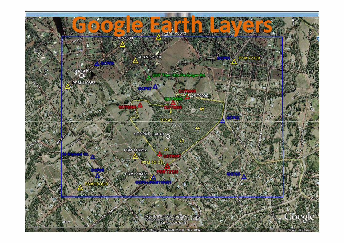
Google Earth LayersGoogle Earth Layers
Developing Spatial Infrastructures for the
QUT- SERF Mr. Robert WEBB15

16Developing Spatial Infrastructures for the QUT- SERF Mr. Robert WEBB

Ortho-Photography Spatial Information Layer
17Developing Spatial Infrastructures for the QUT- SERF Mr. Robert WEBB

OrthoOrtho--Photography Spatial Information LayerPhotography Spatial Information Layer
�Experimental targeting pre-photography
18Developing Spatial Infrastructures for the QUT- SERF Mr. Robert WEBB

580 metre flying height
Intergraph Digital Mapping Camera (DMC)
5 centimetre Ground Sampling Distance
Ortho-Photography Spatial Information Layer
8-bit and 12-bit (filesize about 44 MB per image)
19Developing Spatial Infrastructures for the QUT- SERF Mr. Robert WEBB

ECOLOGY reportECOLOGY report-- Tree speciesTree species
Developing Spatial Infrastructures for the
QUT- SERF Mr. Robert WEBB20

Site Based Management PlanSite Based Management Plan
Developing Spatial Infrastructures for the
QUT- SERF Mr. Robert WEBB21

Concept Plan for SERFConcept Plan for SERF
Developing Spatial Infrastructures for the
QUT- SERF Mr. Robert WEBB22

Ortho-Photography Spatial Information Layer
23Developing Spatial Infrastructures for the QUT- SERF Mr. Robert WEBB

Ortho-Photography Spatial Information Layer
24Developing Spatial Infrastructures for the QUT- SERF Mr. Robert WEBB

100metre Confluence Point Infrastructure
�Aim to place a Survey monument (Galv.
Star Picket) at the Map Grid of Australia
even 100metre confluence points.
�Researchers only needed to check their
relationship relative to a couple of known
100 metre grid points.
25Developing Spatial Infrastructures for the QUT- SERF Mr. Robert WEBB
100 metre grid points.

100metre Confluence Point Infrastructure
26Developing Spatial Infrastructures for the QUT- SERF Mr. Robert WEBB

100metre Confluence Point Infrastructure
�Benefits to wider scientific studies at SERF
�Provides coordinated approach to flora and fauna
sampling – Longitudinal studies every 3 years
27Developing Spatial Infrastructures for the QUT- SERF Mr. Robert WEBB

Engaging Students in Real-World Learning
�Number of Student projects
� Learning Experiences in Real-World Environments
28Developing Spatial Infrastructures for the QUT- SERF Mr. Robert WEBB
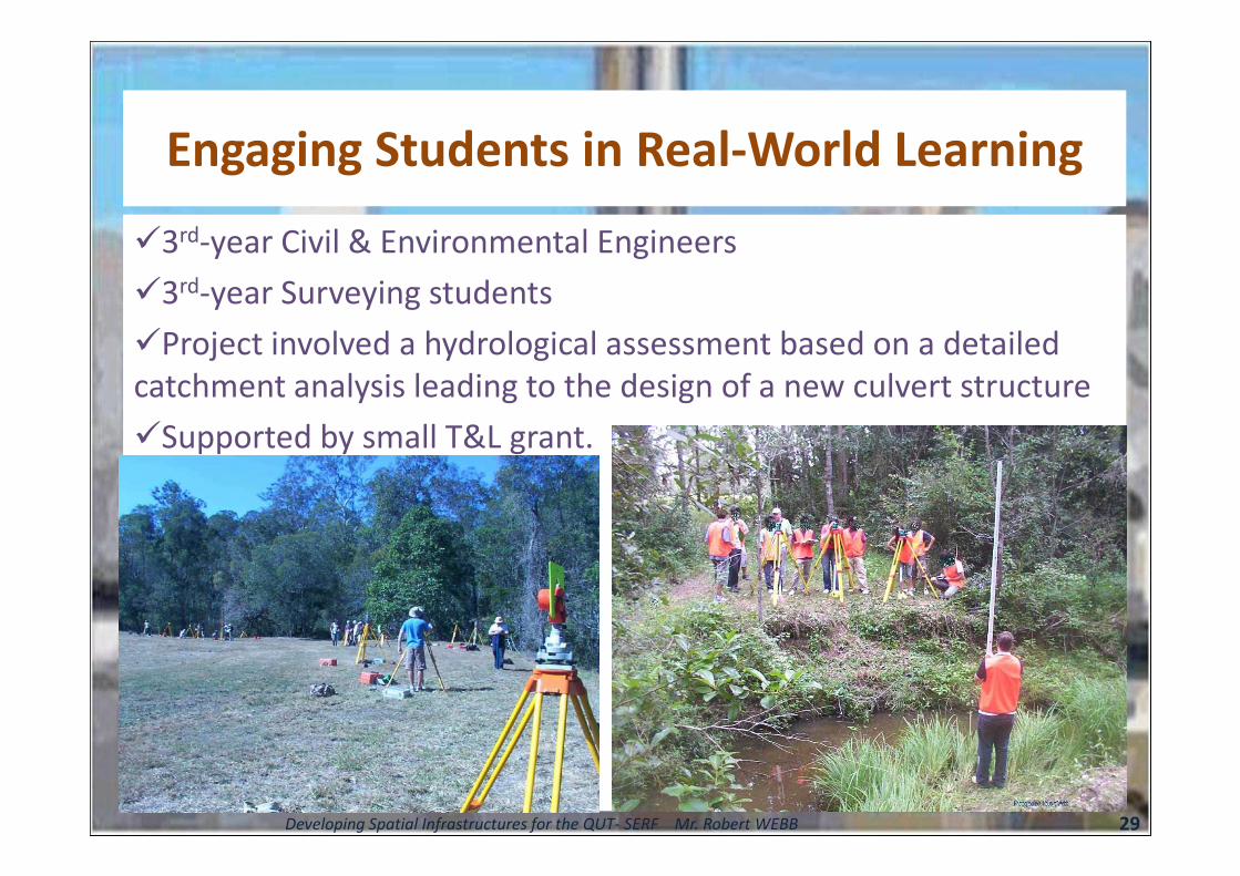
Engaging Students in Real-World Learning
�3rd-year Civil & Environmental Engineers
�3rd-year Surveying students
�Project involved a hydrological assessment based on a detailed
catchment analysis leading to the design of a new culvert structure
�Supported by small T&L grant.�Supported by small T&L grant.
29Developing Spatial Infrastructures for the QUT- SERF Mr. Robert WEBB

Conclusions
� Paper has achieved central aim to provide
description of activities developing site-specific
spatial information layers for the QUT SERF.
� Survey control infrastructure� Survey control infrastructure
� 100meter confluence grid infrastructure
� Ortho-rectified spatial information layer.
� Researchers and student learning experiences
will be enhanced by the creation of these
foundation spatial information layers for
multiple purposes.30Developing Spatial Infrastructures for the QUT- SERF Mr. Robert WEBB

31Developing Spatial Infrastructures for the
QUT- SERF Mr. Robert WEBB