Embed Size (px)
Citation preview
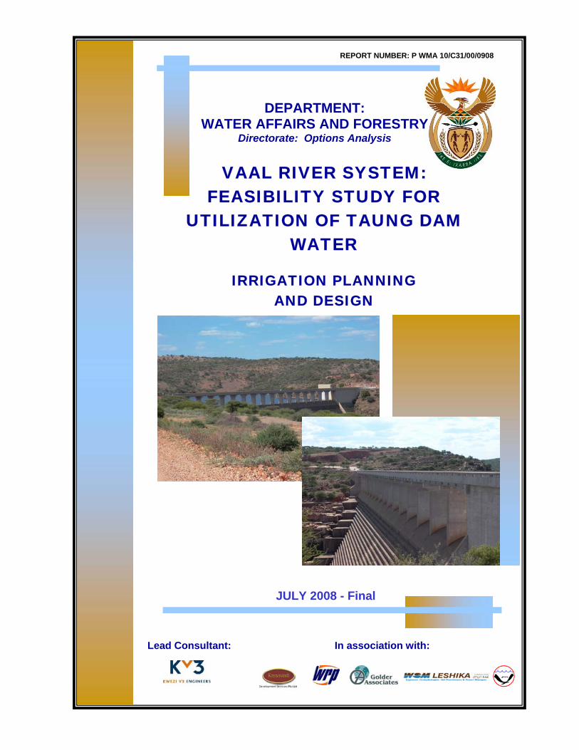
REPORT NUMBER: P WMA 10/C31/00/0908
DEPARTMENT: WATER AFFAIRS AND FORESTRY
Directorate: Options Analysis
Lead Consultant: In association with:
JULY 2008 - Final
VAAL RIVER SYSTEM: FEASIBILITY STUDY FOR
UTILIZATION OF TAUNG DAM WATER
IRRIGATION PLANNING AND DESIGN
Feasibility Study for Utilisation of Taung Dam Water
PWMA 10/31/00/0908 Irrigation Planning and Design July 08
FEASIBILITY STUDY FOR UTILISATION OF TAUNG DAM WATER
MAIN REPORT
PHASE 3
Supporting Report 9
CONVEYANCE SYSTEM SCENARIOS AND
ECONOMIC ANALYSIS
P WMA 10/C31/00/1308
Supporting Report 10
REGIONAL AND NATIONAL ECONOMY
P WMA 10/C31/00/1408
Supporting Report 11
EIA AND PUBLIC PARTICIPATION
P WMA 10/C31/00/1508
PHASE 2
Supporting Report 8
EXISTING AND PROPOSED INFRASTRUCTURE
P WMA 10/C31/00/1208
PHASE 1
Supporting Report 5
IRRIGATION PLANNING AND DESIGN
P WMA 10/C31/00/0908
Supporting Report 6
WATER DEVELOPMENT AND SUPPLY PLANS
P WMA 10/C31/00/1008
Supporting Report 7
WATER QUALITY STATUS OVERVIEW AND
MODELLING
P WMA 10/C31/00/1108
Supporting Report 1
DEMOGRAPHICS
P WMA 10/C31/00/0508
Supporting Report 2
WATER DEMANDS AND USE
P WMA 10/C31/00/0608
Supporting Report 3
YIELD AND SYSTEM ANALYSES
P WMA 10/C31/00/0708
Supporting Report 4
GROUNDWATER RESOURCES OF NALEDI, TAUNG AND PHOKWANE
P WMA 10/C31/00/0808

Feasibility Study for Utilisation of Taung Dam Water
PWMA 10/31/00/0908 Irrigation Planning and Design July 08
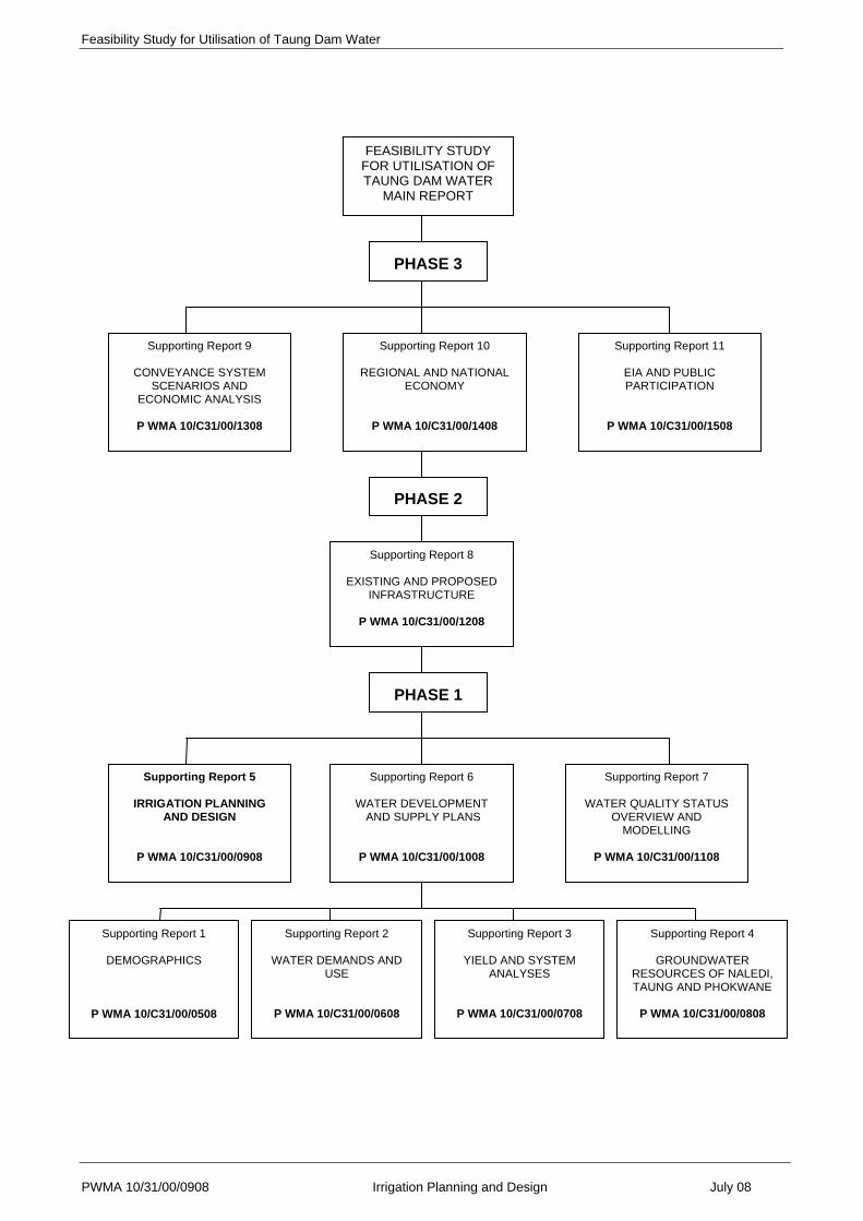
LIST OF REPORTS
REPORT NO DESCRIPTION REPORT NAME
P WMA 10/C31/00/0408 Main Feasibility Report FEASIBILITY STUDY FOR UTILIZATION OF TAUNG DAM WATER: MAIN REPORT
P WMA 10/C31/00/0508 Supporting Report 1 DEMOGRAPHICS
P WMA 10/C31/00/0608 Supporting Report 2 WATER DEMANDS AND USE
P WMA 10/C31/00/0708 Supporting Report 3 YIELD AND SYSTEM ANALYSES
P WMA 10/C31/00/0808 Supporting Report 4 GROUNDWATER RESOURCES
P WMA 10/C31/00/0908 Supporting Report 5 IRRIGATION PLANNING AND DESIGN
P WMA 10/000/00/1008 Supporting Report 6 WATER DEVELOPMENT AND SUPPLY PLANS
P WMA 10/C31/00/1108 Supporting Report 7 WATER QUALITY STATUS OVERVIEW AND MODELLING
P WMA 10/C31/00/1208 Supporting Report 8 EXISTING AND PROPOSED INFRASTRUCTURE
P WMA 10/C31/00/1308 Supporting Report 9 CONVEYANCE SYSTEM SCENARIOS AND ECONOMIC ANALYSIS
P WMA 10/C31/00/1408 Supporting Report 10 REGIONAL AND NATIONAL ECONOMY
P WMA 10/C31/00/1508 Supporting Report 11 EIA AND PUBLIC PARTICIPATION
REFERENCE
This report is to be referred to in bibliographies as:
Department: Water Affairs and Forestry, South Africa, 2007. Feasibility Study for Utilisation of Taung Dam Water: Irrigation Planning and Design: prepared by Golder Associates.
Report No.: P WMA 10/C31/00/0908
Project No.: WP8950 Project File: 14/2/C300/2/2
Feasibility Study for Utilisation of Taung Dam Water (i)
PWMA 10/C31/00/0908 Irrigation Planning and Design July 08
EXECUTIVE SUMMARY
The Taung area has a high agricultural potential, restricted primarily by limited and erratic rainfall.
In the absence of irrigation, some subsistence agriculture is taking place and livestock such as
goats are kept. Communal land ownership does result in over grazing, exacerbated by the
absence of a camping program and fencing.
At present 3 764 Ha are developed for irrigation with 411 farmers. Centre pivots take 2 756 Ha
and sprinklers 1 008 Ha. No surface irrigation is practiced (cf Vaal Harts).
In order to ascertain the potential for expansion, a reconnaissance level survey of areas outside of
the present irrigated lands was undertaken. The survey looked at land potential and also
considered climate and possible crops. In general, the 1:50 000 topographic series mapping was
used as a base map. No existing detailed level soil maps of these areas could be found.
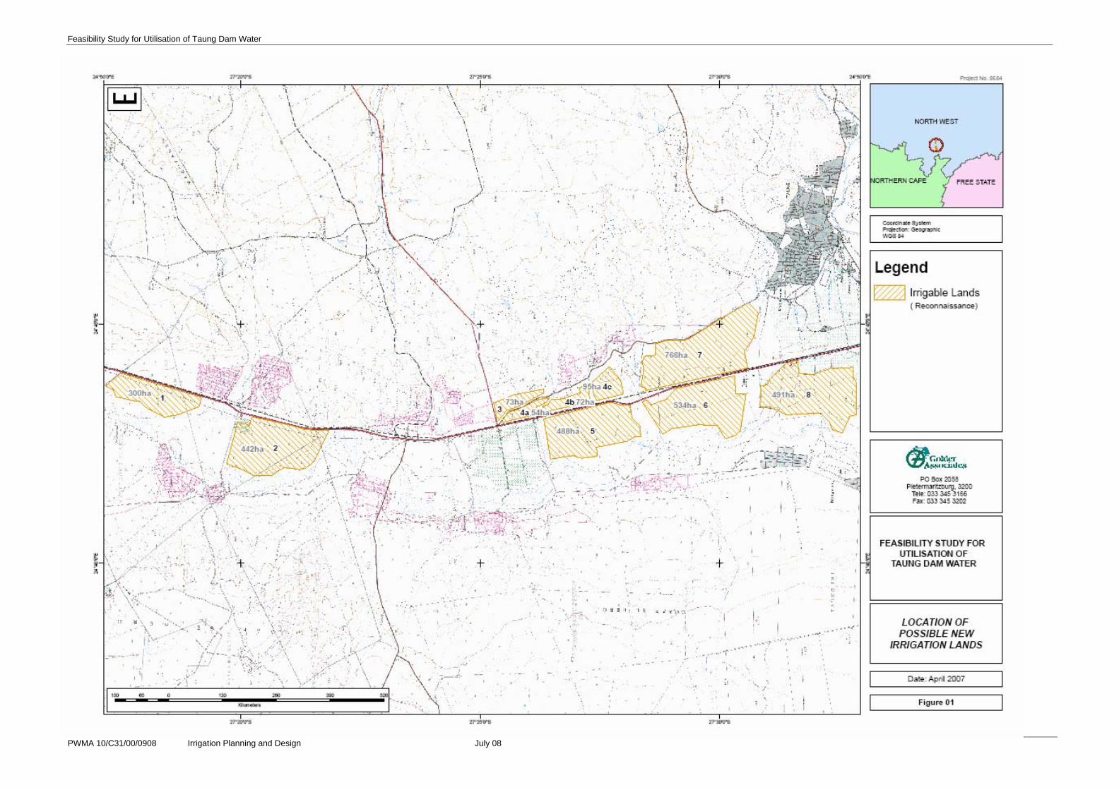
It was found that 3 315 Ha of land were probably acceptable for irrigation development. Eight
separate sites were identified, and arbitrarily named sites 1-8, from north to south (see
Annexure A).
The cropping potential of Taung was considered in respect of soils, land capability and climate.
Existing irrigated cropping patterns were examined and constraints to yield and crop choice were
noted.
A number of crops were short listed for further consideration – based on the inherent agricultural
potential and the choices of the local Department of Agriculture’s staff and the existing farmers.
Water requirements for these crops were then calculated and are shown in Table 3 in the main
body of the report. Table 4 considers the water requirements for two commonly practised crop
rotations, maize-barley – which produces good returns, and lucerne. Lucerne has a very high
potential in the area, and good results have been achieved both at Taung and Vaal Harts.
In order to quantify the amount of water that an expansion of 1 750 Ha would entail, a series of
calculations were undertaken for a maize/barley rotation as well as for perennial lucerne, in terms
of the three possible irrigation methods. System specific efficiencies were used.
These figures, derived from the SAPWAT computer program, gave what can be described as the
‘ideal’ situation, where water is supplied to meet the theoretical crop water demand. However, the
Taung Irrigation Scheme gets its water from the Vaalharts canal system – the conveyance capacity
of which is based on an allocation of 8 417 m³ per hectare per annum. The difference between the
Feasibility Study for Utilisation of Taung Dam Water (ii)
PWMA 10/C31/00/0908 Irrigation Planning and Design July 08
ideal practice and the existing practice is in the order of 56% (i.e. the existing is 56% of the
theoretical requirements).
It was understood that under the water scarce conditions of the Taung area, water use efficiency
was an important aspect. However, also important was the operating costs of the irrigation
systems and the technology employed. Although border strip irrigation was seen to be the least
water efficient of the systems considered (65% as opposed to 75% for sprinkler and 80% for pivot),
it had been shown at Taung that the small farmers have been crippled by high pumping costs
(sprinkler and pivot).
Furthermore, the existing pivot irrigators and pump stations are in a bad state of repair, indicating
that the technologies employed were probably unreasonably complex for most of the small
farmers. It was considered that over-irrigation under border strip irrigation would also help leach
salts from the soil.
For all irrigation types, however, it was felt important that subsurface drains be installed
simultaneously with the irrigation development. This would ensure that the water table is controlled
from the beginning and salinisation is prevented.
A recurrent theme as emphasised to the consultants during their site visit was the expectation of
the “expansion” of Taung Irrigation Scheme. The Department of Agriculture officials and the
community have been anticipating for some time, the expansion of Taung Irrigation Scheme to
cater for persons excluded from the redesign activities in the late 1970’s. During that period the
existing flood irrigation scheme was converted into a centre pivot scheme, with the subsequent
exclusion of 175 persons. Apparently these persons, and in some cases their relatives or
descendants, have been ‘waiting’ all along for restitution. As the re-constituted flood scheme was
designed on the basis of 10 Ha per person, the expectations are for similar areas to be their
allocation if, and when, expansion is effected. This would be a total of 1 750 Ha. The local people
considered in the past that the Taung Dam would be the source of water for this expansion.
This irrigation study therefore assumes that water will eventually be supplied to the 175 farmers for
their 1 750 ha via the standard Taung scheduled rate of 8 417 m³ per hectare, or 14 729 750 m³ in
total.
A further concern expressed during consultations was that of “dry weeks”, a term coined by the
existing farmers for periods when no water reaches them – it being fully abstracted by upstream
Vaal Harts farmers. This is mentioned here in view of the allocation pressures pertaining to Taung
Dam water.
Power costs have been cited as crippling to some farmers.
Feasibility Study for Utilisation of Taung Dam Water (iii)
PWMA 10/C31/00/0908 Irrigation Planning and Design July 08
The study has revealed that Taung Dam would probably be fully subscribed in the provision of
domestic and other primary water users. It has also revealed that additional water is still available
for Taung Irrigation Scheme expansion, also via the Vaalharts main canal and balancing dams.
A request was made, however, to investigate an alternative area to the South East of Taung (Ba-
Ga-Maida) where, using Taung Dam water, irrigation under gravity might be possible. A soil
survey of the Ba-Ga-Maida area had shown 6568ha to be irrigable. This area did not form part of
the Vaalharts or Taung Irrigation Schemes and had no current water allocation from the Vaalharts
Irrigation Scheme.
The capital cost to provide irrigation to this area was subsequently calculated so as to formulate an
opinion as to whether it would be financially viable to implement (should water from the Taung
Dam be available). Six scenarios in respect of water delivery system were investigated.
The total irrigation development costs were found to range between R151,494 and R256,000 per
ha (including bulk and infield infrastructure costs) depending on the scenario. If these amounts
were amortised over a 20 year period with an interest rate of 12% per annum the annual cost
would be R21,000 to R34,000 per ha respectively. Even in respect of high value crops these costs
are economically not viable.
A financial analysis was undertaken on the selected enterprises and on the different irrigation types
proposed. The selected enterprises included:
• Maize
• Barley (in rotation with maize)
• Lucerne
A production programme for the selected enterprises was compiled. From these production
programmes gross margins for the selected enterprise were estimated. Gross margins represent
income from the sale of the crop less all direct costs that can be allocated to the production of the
specific enterprise. The main assumptions for the gross margins are as follows:
Different farmer models have been compiled for the selected rotations for the different irrigation
models. The main cost driver from the irrigation types has been taken from Table 6 included in
Section 5. The areas that can be cropped for each enterprise, assuming optimum irrigation
requirements are also taken from Table 6. The tables below give a summary of the farmer
models.

Feasibility Study for Utilisation of Taung Dam Water (iv)
PWMA 10/C31/00/0908 Irrigation Planning and Design July 08
Farmer Models for Different Irrigation Types for Lucerne
Centre Pivot (4.5 ha cropped)
Sprinkler (4.2 ha cropped)
Border Strip (3.6 ha cropped)
Gross Income 93 960 87 696 75 168
Production Costs 46 370 45 445 31 415
Gross Margin 47 590 42 251 43 753
Overhead Costs 31 476 31 476 31 476
Net Income 16 114 10 775 12 277
Capital Costs 120 000 100 000 80 000
IRR 14.25% 10.15% 17.25%
Farmer Models for Different Irrigation Types for a Maize Barley Rotation
Centre Pivot (4.5 ha cropped)
Sprinkler (4.2 ha cropped)
Border Strip (3.6 ha cropped)
Gross Income 121 815 113 694 97 452
Production Costs 82 268 79 009 59 982
Gross Margin 39 547 34 685 37 470
Overhead Costs 31 476 31 476 31 476
Net Income 8 071 3 209 5 994
Capital Costs 120 000 100 000 80 000
IRR 3.37% -4.25% 4.75%
An internal rate of return for each farmer model was estimated so that the models can be
compared with each other on a financial basis.
It should be noted that these are real returns and exclude inflation. A real return of under 5%
would be considered unviable, between 5 – 10% marginal and above 10% would be considered
viable depending on the risk factor, i.e. the higher the risk, the higher the rate of return. A typical
irrigation scheme would require between 10 – 12% IRR (at least) depending on assumptions (i.e.
costs) included in the financial model.
As a result of the higher capital and pumping costs centre pivot and sprinkler irrigation are less
viable than border strip irrigation. Border strip irrigation is more viable even if it is on a smaller
area. In terms of water use efficiency this is taken into account in financial terms as the model
assumes that 10 Ha is costed (water tariff), however only 3.6 Ha is cropped.
Feasibility Study for Utilisation of Taung Dam Water (v)
PWMA 10/C31/00/0908 Irrigation Planning and Design July 08
In terms of enterprises, lucerne is more viable than the maize/barley rotation however it is more
capital intensive. For resource poor farmers the maize barley rotation may be more affordable. It
should be noted that maize grown on its own is not a viable option.
Feasibility Study for Utilisation of Taung Dam Water (vi)
PWMA 10/C31/00/0908 Irrigation Planning and Design July 08
IRRIGATION PLANNING AND DESIGN
Table of Contents PAGE
EXECUTIVE SUMMARY ................................................................................................................. (i)
1. INTRODUCTION................................................................................................................ 1.1
2. AGRICULTURAL POTENTIAL ......................................................................................... 2.1
2.1. GENERAL.......................................................................................................................................... 2.1
2.2. RECONNAISSANCE LEVEL SURVEY............................................................................................. 2.1
2.3. CROPPING........................................................................................................................................ 2.3
2.4 WATER CONSUMPTION.................................................................................................................. 2.6
3. LAND ISSUES ................................................................................................................... 3.1
4. PLANNING AND DESIGN ................................................................................................. 4.1
4.1. WATER AVAILABILITY ..................................................................................................................... 4.3
5. COSTING ........................................................................................................................... 5.1
6. FINANCIAL ANALYSIS..................................................................................................... 6.1
6.1. GROSS MARGINS ............................................................................................................................ 6.1
6.2. FARMER MODEL.............................................................................................................................. 6.2
7. CONCLUSION ................................................................................................................... 7.1
Feasibility Study for Utilisation of Taung Dam Water (vii)
PWMA 10/C31/00/0908 Irrigation Planning and Design July 08
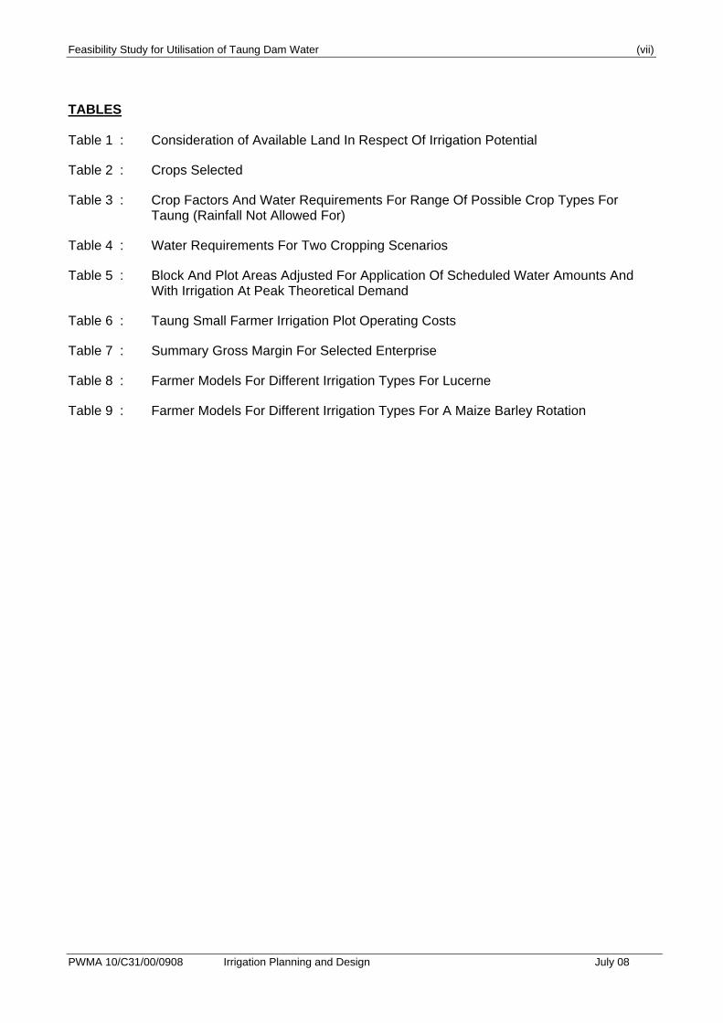
TABLES Table 1 : Consideration of Available Land In Respect Of Irrigation Potential
Table 2 : Crops Selected
Table 3 : Crop Factors And Water Requirements For Range Of Possible Crop Types For Taung (Rainfall Not Allowed For)
Table 4 : Water Requirements For Two Cropping Scenarios
Table 5 : Block And Plot Areas Adjusted For Application Of Scheduled Water Amounts And With Irrigation At Peak Theoretical Demand
Table 6 : Taung Small Farmer Irrigation Plot Operating Costs
Table 7 : Summary Gross Margin For Selected Enterprise
Table 8 : Farmer Models For Different Irrigation Types For Lucerne
Table 9 : Farmer Models For Different Irrigation Types For A Maize Barley Rotation
Feasibility Study for Utilisation of Taung Dam Water (viii)
PWMA 10/C31/00/0908 Irrigation Planning and Design July 08
ANNEXURES
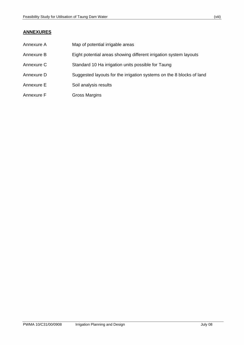
Annexure A Map of potential irrigable areas
Annexure B Eight potential areas showing different irrigation system layouts
Annexure C Standard 10 Ha irrigation units possible for Taung
Annexure D Suggested layouts for the irrigation systems on the 8 blocks of land
Annexure E Soil analysis results
Annexure F Gross Margins
Feasibility Study for Utilisation of Taung Dam Water 1.1
PWMA 10/C31/00/0908 Irrigation Planning and Design July 08
1. INTRODUCTION
This report covers Task 5: Irrigation, under Phase 1: Determination of Dam Yield and
Water Demand.
Currently the Taung Dam water resource is not utilised at all, and simply impounds
some of the flow of the Harts River, providing a large surface area from which water is
lost to the atmosphere by evaporation. The main aim of Task 5 was to determine
whether opening up new irrigation areas in Taung Irrigation Scheme using water from
Taung Dam will be economical and sustainable. The modern approach to
sustainability considers whether social, economic and environmental components are
sufficiently balanced to ensure long-term viability. If any of these components are
under pressure then the planned development is unlikely to succeed in the long-term.
From an environmental perspective, parts of the neighbouring Vaalharts Irrigation
scheme are severely salinised, and care needs to be taken to ensure that any new
irrigation areas in Taung Scheme have sufficient drainage and leaching water flows to
maintain crop productivity. The National Department of Agriculture has embarked on a
strategy to improve the network of drains to enable leaching of the salts in both
Vaalharts Irrigation Scheme and the existing area under irrigation in the Taung
Irrigation Scheme. The additional water required for leaching of salts down to an
acceptable salinity level will also increase pressure on the total water demand for the
Taung Scheme basic natural resource scoping.
The Taung area was examined in respect of its natural resources – particularly
regarding the potential agricultural usage of Taung Dam water. This included survey of
lands available and the cropping potential. The Taung Dam, which is the expected
source of water, was visited. The existing water source (Vaal Harts North Canal) and
the existing canals and associated infrastructure were inspected. Data in respect of
climate was obtained and calculations made in respect of cropping potential. Some
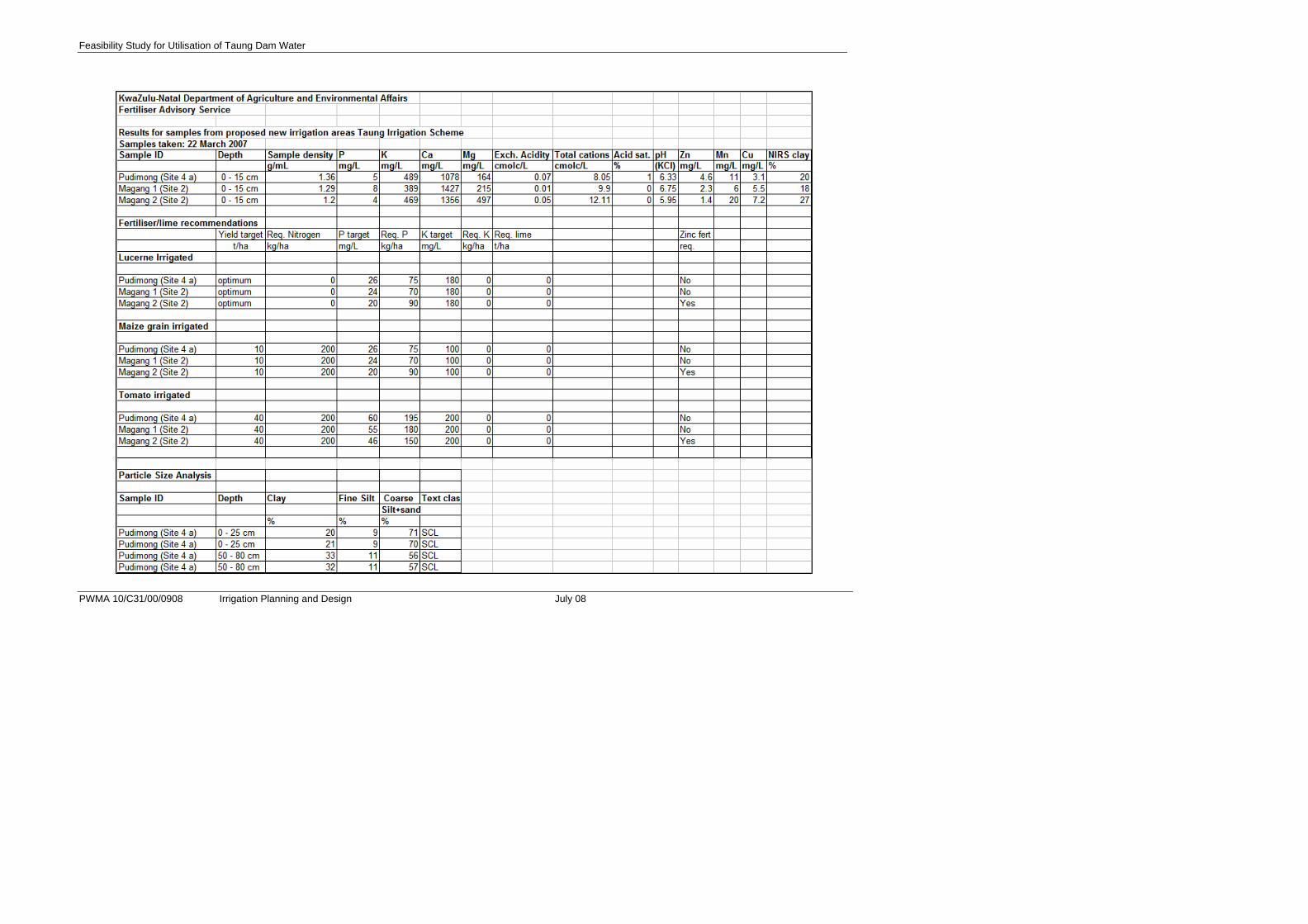
soils were sampled for nutrient status and texture from Site 2 and 4a (see
Annexure E). Soil fertility recommendations were done for irrigated lucerne, maize
and tomato. Site 4a is approximately central to the proposed new irrigated areas. The
sampling was intended to gain an understanding of the chemical and physical status of
‘typical’ Taung soils. It must be emphasised that a comprehensive soil survey has not
been undertaken. Should the irrigation development/expansion, or some part of it be
given the go-ahead, then a detailed soil survey should be carried out of the probable
irrigable areas.
Feasibility Study for Utilisation of Taung Dam Water 1.2
PWMA 10/C31/00/0908 Irrigation Planning and Design July 08
The soil samples taken in Site 4a were analysed for particle sizes within the clay, fine
silt and coarse silt and sand classes. The results indicate sandy clay loam soils of
800 mm depth. Clay contents increased from 21 % in the 0 – 250mm layer to 33 % in
the 500–800mm layer, with coarse silt and sand fractions of 71 and 57 %, respectively.
These sandy clay loam soils are unlikely to present drainage limitations within the 0 –
800mm layer, which is considered an adequate rooting depth for most field crops.
With irrigation, the Taung scheme should be capable of matching the high unit
agricultural output of the adjacent Vaalharts Irrigation scheme. The climate is suitable
for a variety of crops, such as maize, barley, sunflower, cotton, groundnut and lucerne,
and orchard crops such as olives, grapes, citrus and pecan do well.
Feasibility Study for Utilisation of Taung Dam Water 2.1
PWMA 10/C31/00/0908 Irrigation Planning and Design July 08
2. AGRICULTURAL POTENTIAL
2.1. General
The Taung area has a high agricultural potential, restricted primarily by limited and
erratic rainfall. In the absence of irrigation, some subsistence agriculture is taking place
and livestock such as goats are kept. Communal land ownership does result in over
grazing, exacerbated by the absence of a camping program and fencing.
At present 3 764 Ha are developed for irrigation with 411 farmers. Centre pivots take
2 756 Ha and sprinklers 1 008 Ha. No surface irrigation is practiced (cf Vaal Harts).
The choice for installing centre pivots was made in the late 1970’s (under Agricor).
The objective was an attempt to militate against the rising water tables in the existing
surface irrigation scheme. It was felt that the greater application efficiency of pivots
over flood irrigation would minimise losses to deep percolation, so controlling and
eventually lowering the water table.
However, it has been shown over the years that the water table has not receded and in
most cases has continued to rise (local communication), albeit at a slower rate.
The results under pivots are mixed, with some excellent cropping occurring under
some pivots, and no cropping evident under others. In some circumstances the pivots
are standing – unserviceable and not in use.
The problems associated with the existing scheme vary from land ownership problems
to vandalism.
2.2. Reconnaissance Level Survey
In order to ascertain the potential for expansion, a reconnaissance level survey of
areas outside of the present irrigated lands was undertaken. The survey looked at land
potential and also considered climate and possible crops. In general, the 1:50 000
topographic series mapping was used as a base map. No existing detailed level soil
maps of these areas could be found.
Factors such as land slope, texture, stoniness, wetness, flooding potential, soil-depth
and erosion hazard were considered. This site analysis was augmented by
examination of 1:10 000 ortho-photos. Satellite imagery was used to identify
potentially wet areas.
Feasibility Study for Utilisation of Taung Dam Water 2.2
PWMA 10/C31/00/0908 Irrigation Planning and Design July 08
All the land examined was first indicated to the consultants as being available for
development by the Extension Staff and the Tribal Authority.
It was found that 3 315 Ha of land were probably acceptable for irrigation development.
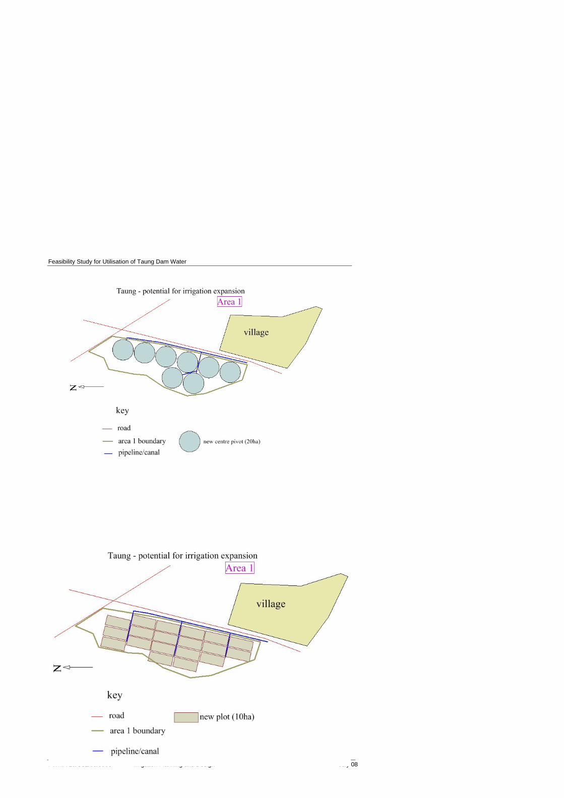
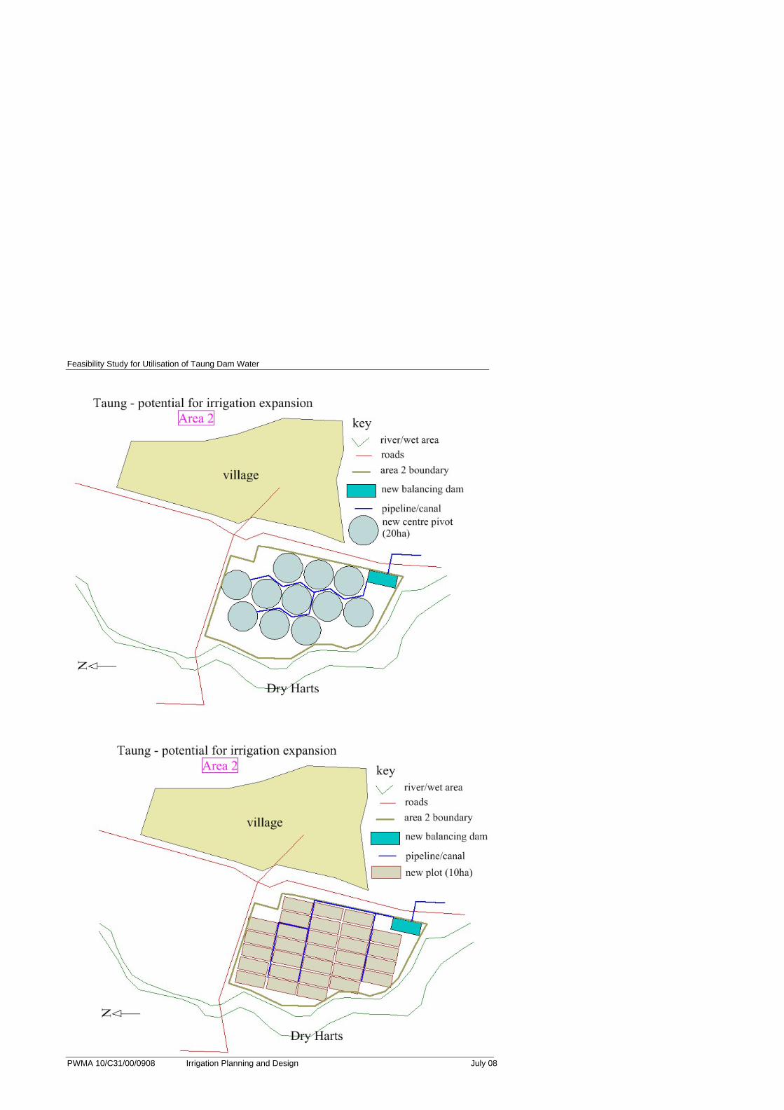
Eight separate sites were identified, and arbitrarily named sites 1-8, from north to south
(see Annexure A).
Table 1 shows the identified land together with positive and negative aspects of each:
Table 1: Consideration of Available Land in Respect of Irrigation Potential
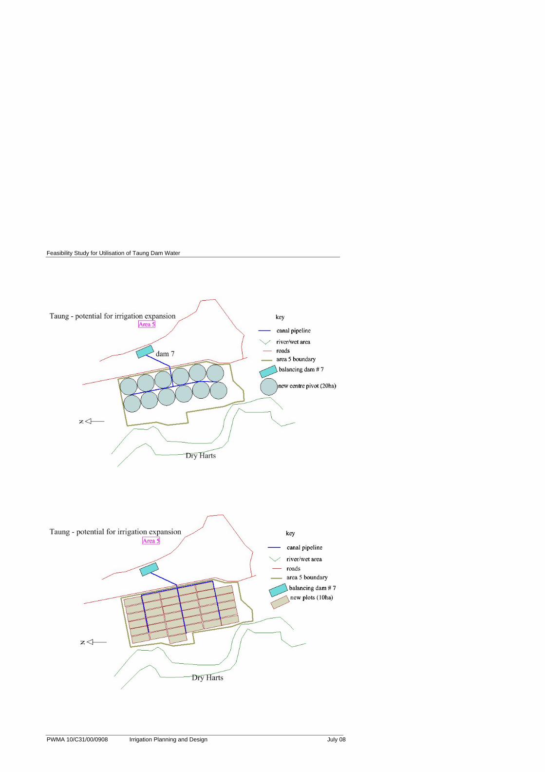
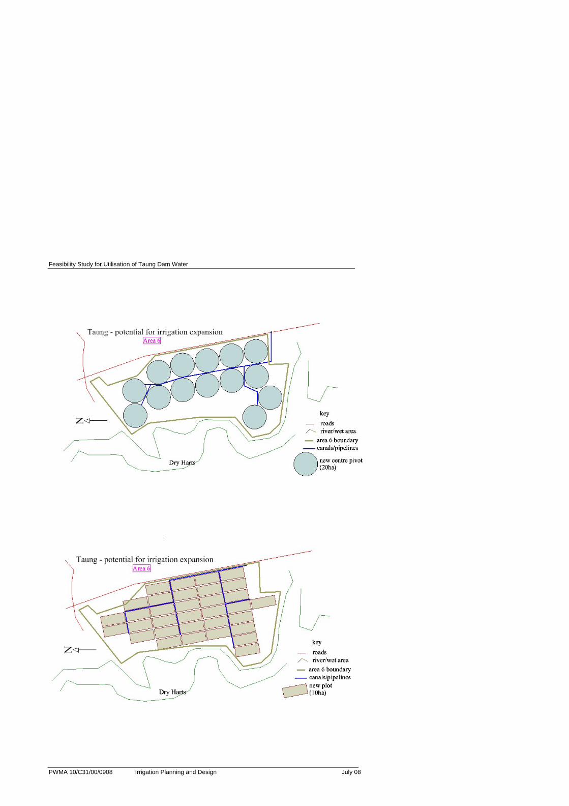
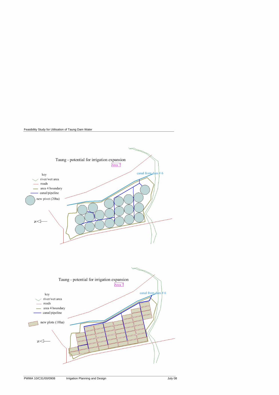
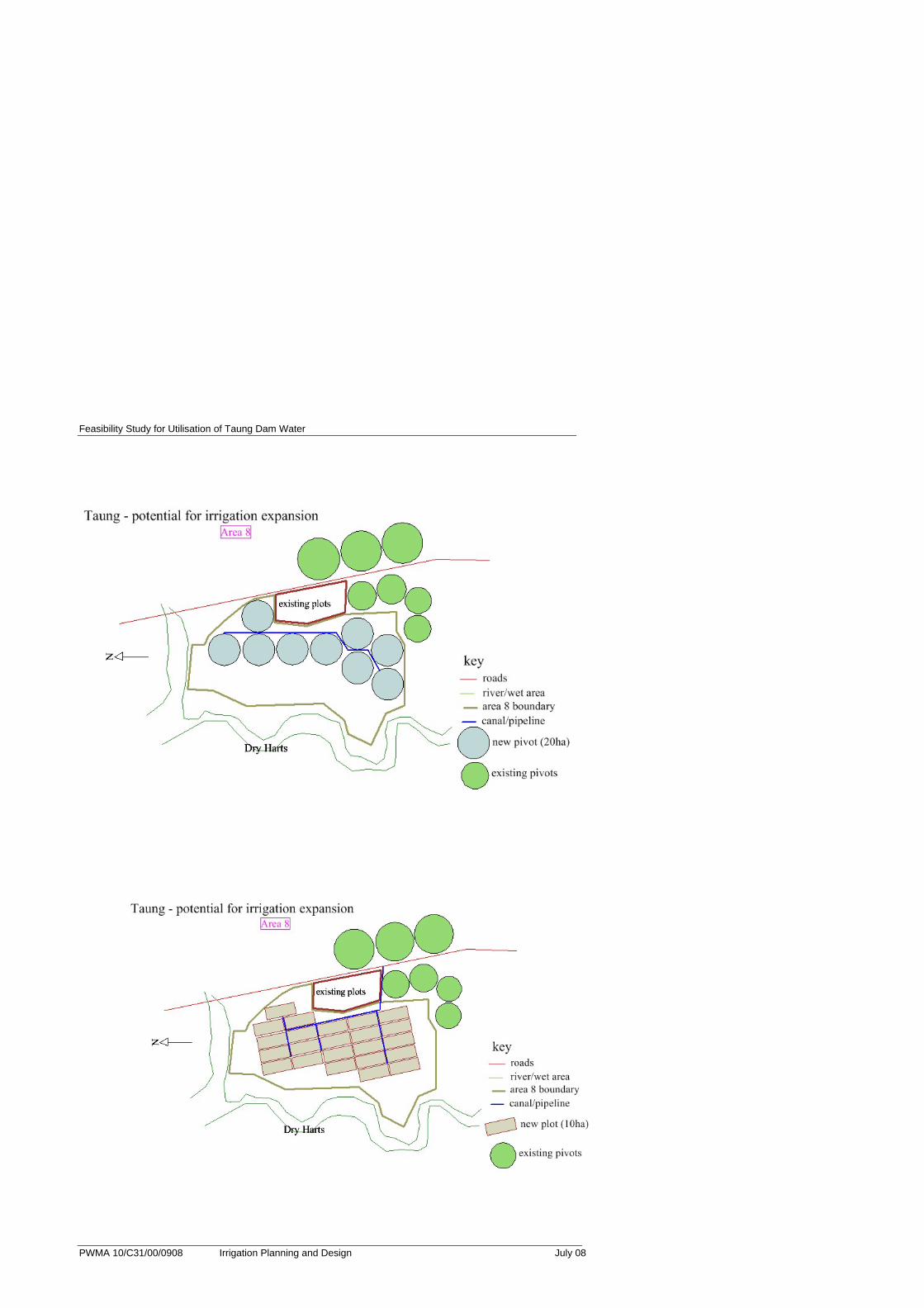
Area #
Gross Area Ha
Positive Aspects Negative Aspects 1st Choice Ha
2nd Choice Ha
1 300 Medium to good quality land Greatest distance from source
300
2 442 Good quality land Some distance from source
442
3 73 Elongated and follows canal closely
High elevation – above existing canal
73
4 221 In command of dam 7; good quality land
Divided into relatively small blocks
221
5 488 Low elevation; below dam 7 Medium quality land; possible minor drainage problem
488
6 534 Low elevation Medium quality land; possible drainage problem
534
7 766 Below existing canal; medium to good quality land
Slightly steep (1:400) 766
8 491 Low elevation; below dam 6 Medium quality land; possible drainage problem
491
3315 1917 1398
3315
It must be emphasised, however, that before any detailed planning takes place, a
detailed soil survey should be carried out on these identified ‘potential’ areas, so as to
confirm the reconnaissance work.
The particle size analysis for the soil samples taken at Site 4 a (discussed under
Section 1 and presented in Annexure E) indicates sand clay loam soils to 800mm
depth. These sandy clay loam soils have adequate rooting depth for most agronomic
crops and are unlikely to present drainage limitations, making them suitable for
irrigated crop production.

Feasibility Study for Utilisation of Taung Dam Water 2.3
PWMA 10/C31/00/0908 Irrigation Planning and Design July 08
The possible irrigable land was mapped (Annexure A) with 1:50 000 topographic
maps as base.
2.3. Cropping
The cropping potential of Taung was considered in respect of soils, land capability and
climate. Existing irrigated cropping patterns were examined and constraints to yield
and crop choice were noted.
A number of crops were short listed for further consideration – based on the inherent
agricultural potential and the choices of the local Department of Agriculture’s staff and
the existing farmers.
Table 2: Crops Selected
Crop Season Reason for Inclusion
Barley Winter Grown on contract with South African Maltsters (SAM)
Lucerne All year Widely grown, markets with feedlots/dairies, ideal climate for cutting and baling
Tomato Summer Popular on local market in Taung
Onion Winter Popular on local market in Taung
Pumpkin Summer Popular on local market and low-tech storage required (in open)
Maize Summer Grown on contract with South African Maltsters (SAM)
Potato Autumn Popular on local market in Taung
Groundnut Summer Market through Groundnut International (GNI)
Sunflower Summer Good market for oil pressing, good for nutrient cycling being deep rooted
Cabbage Winter Popular on local market in Taung
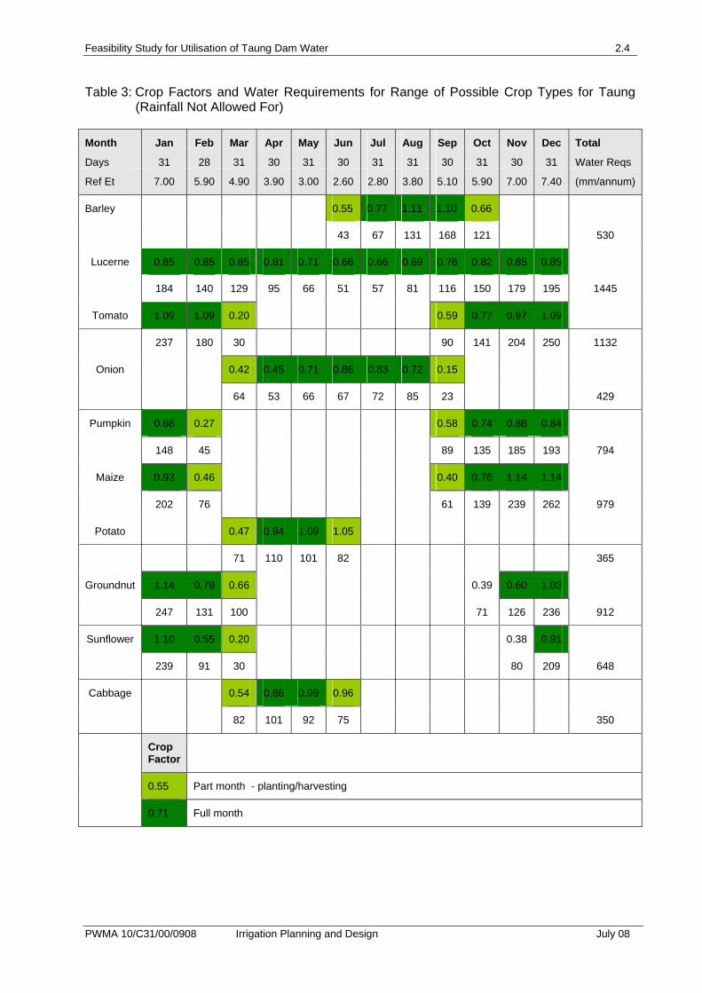
Water requirements for these crops were then calculated. The water requirements for
these crops are shown in Table 3. Table 4 considers the water requirements for two
commonly practised crop rotations, maize-barley – which produces good returns, and
lucerne. Lucerne has a very high potential in the area, and good results have been
achieved both at Taung and Vaal Harts.
Feasibility Study for Utilisation of Taung Dam Water 2.4
PWMA 10/C31/00/0908 Irrigation Planning and Design July 08
Table 3: Crop Factors and Water Requirements for Range of Possible Crop Types for Taung (Rainfall Not Allowed For)
Month Jan Feb Mar Apr May Jun Jul Aug Sep Oct Nov Dec Total
Days 31 28 31 30 31 30 31 31 30 31 30 31 Water Reqs
Ref Et 7.00 5.90 4.90 3.90 3.00 2.60 2.80 3.80 5.10 5.90 7.00 7.40 (mm/annum)
Barley 0.55 0.77 1.11 1.10 0.66
43 67 131 168 121 530
Lucerne 0.85 0.85 0.85 0.81 0.71 0.66 0.66 0.69 0.76 0.82 0.85 0.85
184 140 129 95 66 51 57 81 116 150 179 195 1445
Tomato 1.09 1.09 0.20 0.59 0.77 0.97 1.09
237 180 30 90 141 204 250 1132
Onion 0.42 0.45 0.71 0.86 0.83 0.72 0.15
64 53 66 67 72 85 23 429
Pumpkin 0.68 0.27 0.58 0.74 0.88 0.84
148 45 89 135 185 193 794
Maize 0.93 0.46 0.40 0.76 1.14 1.14
202 76 61 139 239 262 979
Potato 0.47 0.94 1.09 1.05
71 110 101 82 365
Groundnut 1.14 0.79 0.66 0.39 0.60 1.03
247 131 100 71 126 236 912
Sunflower 1.10 0.55 0.20 0.38 0.91
239 91 30 80 209 648
Cabbage 0.54 0.86 0.99 0.96
82 101 92 75 350
Crop Factor
0.55 Part month - planting/harvesting
0.71 Full month
Feasibility Study for Utilisation of Taung Dam Water 2.5
PWMA 10/C31/00/0908 Irrigation Planning and Design July 08
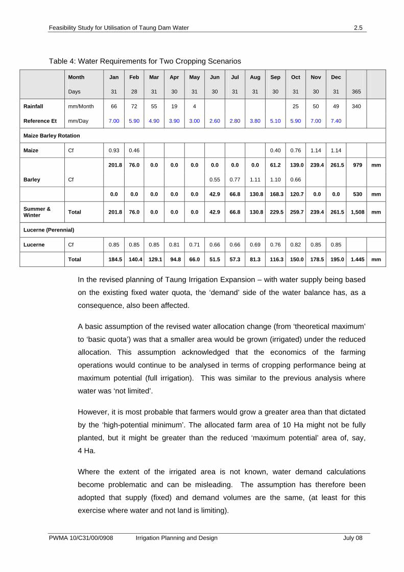
Table 4: Water Requirements for Two Cropping Scenarios
Month Jan Feb Mar Apr May Jun Jul Aug Sep Oct Nov Dec
Days 31 28 31 30 31 30 31 31 30 31 30 31 365
Rainfall mm/Month 66 72 55 19 4 25 50 49 340
Reference Et mm/Day 7.00 5.90 4.90 3.90 3.00 2.60 2.80 3.80 5.10 5.90 7.00 7.40
Maize Barley Rotation
Maize Cf 0.93 0.46 0.40 0.76 1.14 1.14
201.8 76.0 0.0 0.0 0.0 0.0 0.0 0.0 61.2 139.0 239.4 261.5 979 mm
Barley Cf 0.55 0.77 1.11 1.10 0.66
0.0 0.0 0.0 0.0 0.0 42.9 66.8 130.8 168.3 120.7 0.0 0.0 530 mm
Summer & Winter Total 201.8 76.0 0.0 0.0 0.0 42.9 66.8 130.8 229.5 259.7 239.4 261.5 1,508 mm
Lucerne (Perennial)
Lucerne Cf 0.85 0.85 0.85 0.81 0.71 0.66 0.66 0.69 0.76 0.82 0.85 0.85
Total 184.5 140.4 129.1 94.8 66.0 51.5 57.3 81.3 116.3 150.0 178.5 195.0 1.445 mm
In the revised planning of Taung Irrigation Expansion – with water supply being based
on the existing fixed water quota, the ‘demand’ side of the water balance has, as a
consequence, also been affected.
A basic assumption of the revised water allocation change (from ‘theoretical maximum’
to ‘basic quota’) was that a smaller area would be grown (irrigated) under the reduced
allocation. This assumption acknowledged that the economics of the farming
operations would continue to be analysed in terms of cropping performance being at
maximum potential (full irrigation). This was similar to the previous analysis where
water was ‘not limited’.
However, it is most probable that farmers would grow a greater area than that dictated
by the ‘high-potential minimum’. The allocated farm area of 10 Ha might not be fully
planted, but it might be greater than the reduced ‘maximum potential’ area of, say,
4 Ha.
Where the extent of the irrigated area is not known, water demand calculations
become problematic and can be misleading. The assumption has therefore been
adopted that supply (fixed) and demand volumes are the same, (at least for this
exercise where water and not land is limiting).
Feasibility Study for Utilisation of Taung Dam Water 2.6
PWMA 10/C31/00/0908 Irrigation Planning and Design July 08
Rainfall does not easily fit into this assumption, and it would be unlikely that farmers
would plan to alter their ‘fully irrigated’ area on the possibility of rain.
Furthermore, with irrigation in a semi arid area (only 250 mm effective rainfall) and with
high variability – both spatially and temporally, the addition of rainfall would not serve
to increase accuracy of planning.
Basically therefore, with or without rainfall the same water demand will apply
(equivalent to quota) and the area allocated to full irrigation will also be unchanged.
Thus the supply infrastructure will be unaffected by the addition of rainfall, and the core
economic calculations of returns per fully irrigated unit of land will also be unaffected.
Rainfall has therefore been excluded from the water demand calculations in respect of
the revised planning based on water quotas.
The only effect that rainfall will have for the farmer will be for him to increase his overall
planted area in summer (with the attendant risk). For the water supply authority, the
rainfall effect would be to allow cut-back on rotational streams during the rainy period,
but the farmer would require his total balance to be made up over the longer term.
Infrastructure design would be based on peak demand and would not include rainfall.
2.4. Water Consumption
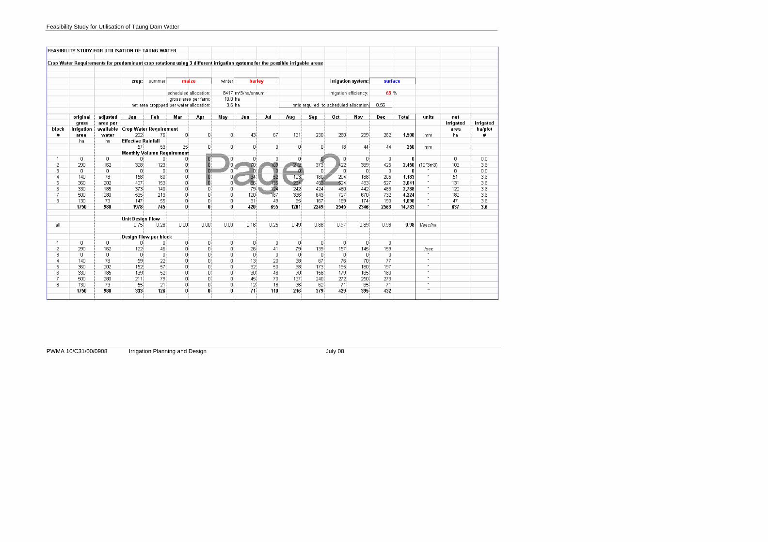
In order to quantify the amount of water that an expansion of 1 750 Ha would entail, a
series of calculations were undertaken for a maize/barley rotation as well as for
perennial lucerne – in terms of the three possible irrigation methods. System specific
efficiencies were used.
These figures, derived from the SAPWAT computer program, gave what can be
described as the ‘ideal’ situation, where water is supplied to meet the theoretical crop
water demand. However, the Taung Irrigation Scheme gets its water from the
Vaalharts canal system – the conveyance capacity of which is based on an allocation
of 8 417 m³ per hectare per annum. The difference between the ideal practice and the
existing practice is in the order of 56% (i.e. the existing is 56% of the theoretical
requirements).
The calculations carried out for the irrigation water requirements for Taung expansion
had then to take into account the differences between the theoretical crop water
requirement and the scheduled water.
Feasibility Study for Utilisation of Taung Dam Water 2.7
PWMA 10/C31/00/0908 Irrigation Planning and Design July 08
The following assumptions were made:
• The theoretical demand for lucerne is 14 450m³/ha/annum and for maize/barley
rotation, 15 080 m³/ha/annum
• Only 8 417 m³/ha is available (55% and 58% of requirement respectively)
• The scheduled amount is a gross figure – requiring that efficiency losses are
subtracted from it - as applicable to each irrigation method. The net irrigation
figure will be substantially less than the gross scheduled figure. It is assumed,
however, that the scheduled amount is a ‘field edge’ figure, and that all
conveyance losses have been subtracted. This has therefore been excluded
from our calculations.
• The total water available to the expansion will be based on the 175 farmers each
with 10 Ha of land; therefore the total scheduled volume for Taung expansion is
14 729 750 m³.
• As the supply will be less than the demand in respect of the 10 Ha of irrigation,
the farmer will have the choice of using the lesser amount over his full 10 Ha, or
to apply the theoretical amount over a smaller area. However, water will still be
supplied at the required rate and will in the end comprise the scheduled amount
of 84 170 m³ per 10 Ha farm.
• The calculations to accommodate the use of scheduled irrigation water have used
reduced area (within each 10ha farm) as the variable leaving the scheduled
volumes and theoretical demands unaltered.
• Slightly improved irrigation efficiencies are used as it is assumed that a greater
care will be taken of the lower applications – and wastage will be limited.
• Effective rainfall has not been included in the water requirement calculations as
with the partially covered lands it is difficult to calculate. It also will not affect the
total water supplied as per schedule – unless surplus rainfalls are experienced
over the seasons. However, rainfall will certainly assist the farmers with possible
crop production increases if the full areas are planted.
As it is impossible to accurately calculate the economic returns on a farm using both
variable water applications and variable planted areas - the attached economic
analysis has been carried out as follows:
• Each farm is analysed on the basis of using the theoretical peak production
amounts of water per hectare.
Feasibility Study for Utilisation of Taung Dam Water 2.8
PWMA 10/C31/00/0908 Irrigation Planning and Design July 08
• The possible area to be planted under the circumstance of water curtailment has
been calculated, and has been used for each farm under the various irrigation
types. (See tables).
• The farmer may risk planting a greater area (with perhaps a lower yield), but this
has not been included in the calculations.
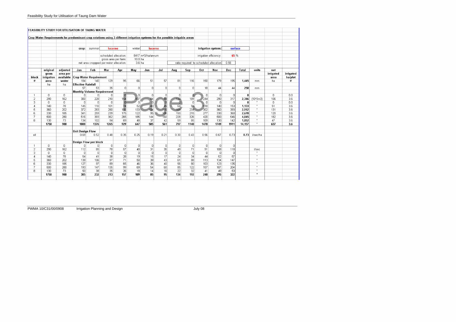
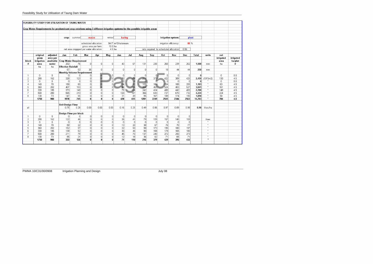
Five tables in Annexure B show monthly water requirements for three irrigation
systems and for two crop rotations and have been adjusted to take cognisance of the
scheduled irrigation amounts.
The tables also show the calculations carried out to determine the maximum amount of
land area that could be cropped and irrigated on a 10 Ha farm using the total crop
water requirement as calculated in the previous section, but restricted to the scheduled
amount for the full 10 Ha allocation. The various irrigation efficiencies have also been
taken into account.
Feasibility Study for Utilisation of Taung Dam Water 2.9
PWMA 10/C31/00/0908 Irrigation Planning and Design July 08
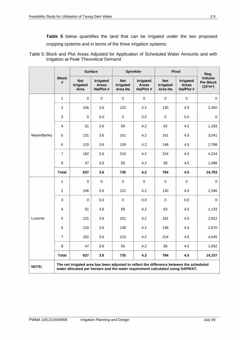
Table 5 below quantifies the land that can be irrigated under the two proposed
cropping systems and in terms of the three irrigation systems.
Table 5: Block and Plot Areas Adjusted for Application of Scheduled Water Amounts and with Irrigation at Peak Theoretical Demand
Surface Sprinkler Pivot
Block # Net
Irrigated Area
Irrigated Areas
Ha/Plot #
Net Irrigated Area Ha
Irrigated Areas
Ha/Plot #
Net Irrigated Area Ha
Irrigated Areas
Ha/Plot #
Reg. Volume
Per Block (10³m³)
1 0 0 0 0 0 0 0
2 106 3.6 122 4.2 130 4.5 2,450
3 0 0.0 0 0.0 0 0.0 0
4 51 3.6 59 4.2 63 4.5 1,183
5 131 3.6 151 4.2 161 4.5 3,041
6 120 3.6 139 4.2 148 4.5 2,788
7 182 3.6 210 4.2 224 4.5 4,224
8 47 3.6 55 4.2 58 4.5 1,098
Maize/Barley
Total 637 3.6 735 4.2 784 4.5 14,783
1 0 0 0 0 0 0 0
2 106 3.6 122 4.2 130 4.5 2,346
3 0 0.0 0 0.0 0 0.0 0
4 51 3.6 59 4.2 63 4.5 1,133
5 131 3.6 151 4.2 161 4.5 2,912
6 120 3.6 139 4.2 148 4.5 2,670
7 182 3.6 210 4.2 224 4.5 4,045
8 47 3.6 55 4.2 58 4.5 1,052
Lucerne
Total 637 3.6 735 4.2 784 4.5 14,157
NOTE: The net irrigated area has been adjusted to reflect the difference between the scheduled water allocated per hectare and the water requirement calculated using SAPWAT.

Feasibility Study for Utilisation of Taung Dam Water 3.1
PWMA 10/C31/00/0908 Irrigation Planning and Design July 08
3. LAND ISSUES
The recurrent theme as emphasised to the consultants during their site visit was the
expectation of the “expansion” of Taung Irrigation Scheme. The Department of
Agriculture officials and the community have been anticipating for some time, the
expansion of Taung Irrigation Scheme to cater for persons excluded from the redesign
activities in the late 1970’s. During that period the existing flood irrigation scheme was
converted into a centre pivot scheme, with the subsequent exclusion of 175 persons.
Apparently these persons, and in some cases their relatives or descendants, have
been ‘waiting’ all along for restitution. As the re-constituted flood scheme was designed
on the basis of 10 Ha per person, the expectations are for similar areas to be their
allocation if, and when, expansion is effected. This would be a total of 1 750 Ha. The
local people considered in the past that the Taung Dam would be the source of water
for this expansion
Thus it was the point of departure for the consultants to survey the surrounding tribal
areas to determine whether or not irrigable lands of this scale existed.
Another concern expressed during consultations was that of “dry weeks”, a term
coined by the existing farmers for periods when no water reaches them – it being fully
abstracted by upstream Vaal Harts farmers. This is mentioned here in view of the
allocation pressures pertaining to Taung Dam water.
The choice of centre pivots by Agricor for the re-formatting of Taung may not have
been appropriate in the first place, as the pivots have to be shared by the farmers in
order to make up the required number of allotments. Each farmer has 10 Ha under
irrigation – with, for example, four farmers working the 40 Ha pivots and two farmers
the 20 Ha machines. This shared farming approach causes problems in respect of
operating costs, cropping programs and harvesting.
Power costs have been cited as crippling to some farmers. In other cases, only part of
the circle is cropped, one or more of the farmers skipping a crop on their portion. In
many cases, the farmers hire out their land and pivot irrigator to non-resident
commercial farmers, mainly from the Vaalharts scheme. This results in ‘tenant
agriculture’, with the associated minimal interest of the lessee in the conservation of
the land resource. The owners usually pay for electricity and water; the tenant sharing
the returns on the crops produced. This practice does not encourage local farmers to
embrace the role and responsibilities of commercial agriculture.
Feasibility Study for Utilisation of Taung Dam Water 4.1
PWMA 10/C31/00/0908 Irrigation Planning and Design July 08
4. PLANNING AND DESIGN
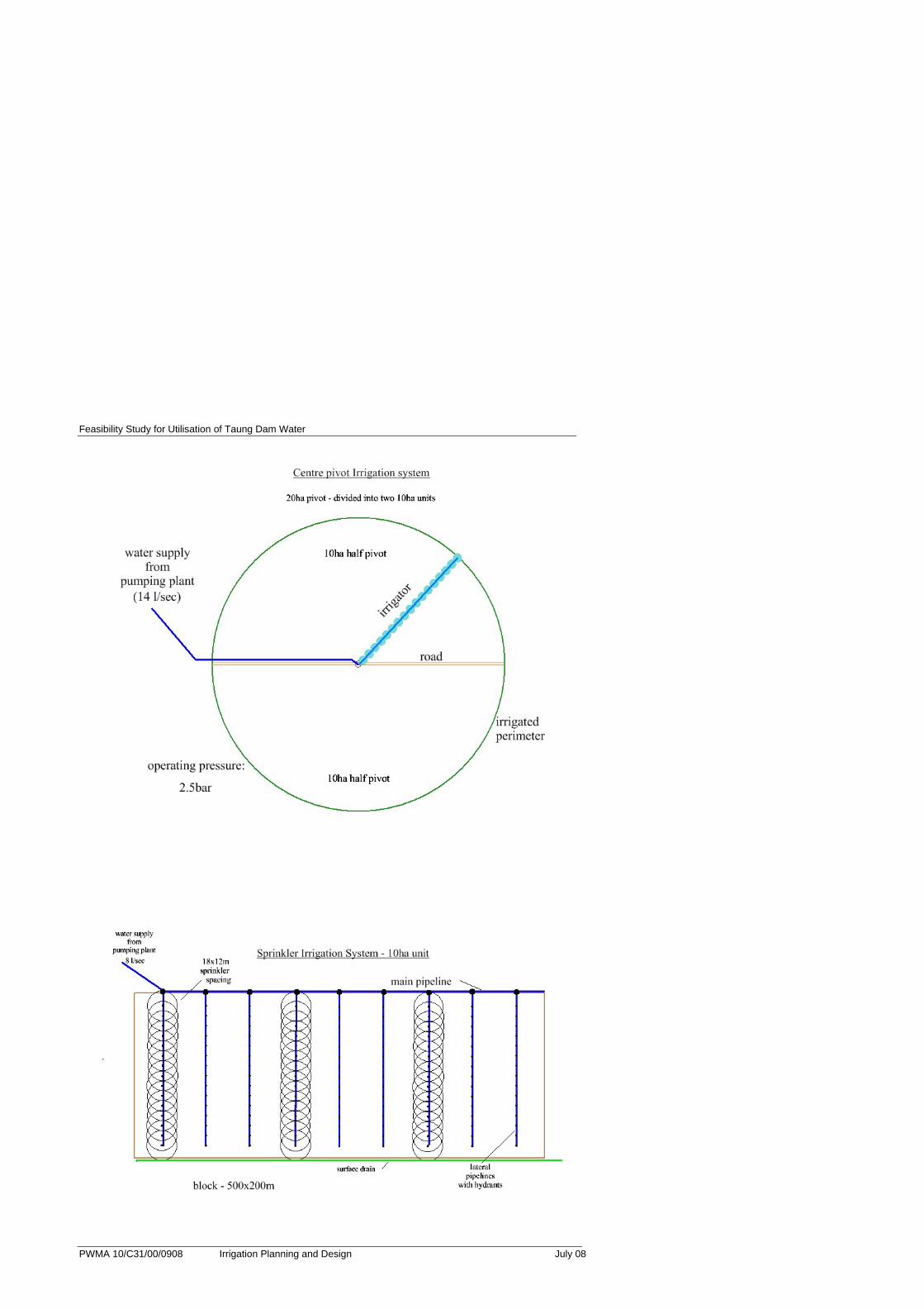
Three possible methods of irrigation were considered, namely:
• Centre Pivot
• Sprinkler
• Surface – border strip
These three methods were looked at primarily for the following reasons:
1. They are currently in use at Taung (familiar to the local farmers)
2. The centre pivots are at present the system of choice (ease of operation)
3. Border strip has been successful in the past – and it uses the least energy
Typical layouts of these three systems are shown in Annexure C.
Each method was examined from the aspects of water use efficiency, capital cost,
operating cost, ease of maintenance, labour requirement and local experience.
It was considered important to examine carefully any recommendation for future
developments in the light of prevailing constraints – as outlined above.
For all irrigation types considered, it was felt important that subsurface drains be
installed simultaneously with the irrigation development. This would ensure that the
water table is controlled from the beginning and salinisation is prevented.
Some comments on the three possible irrigation methods follow:
Centre pivot
This is the dominant system that exists at Taung at present. Most farmers appear to
be satisfied with this system, but there are a number of drawbacks. Pivots have a
relatively high capital cost, and their operating costs, with respect to electricity are also
high.
They are subject to wind drift and runoff at the ends, where high precipitation rates
occur. There is a problem at present with maintenance, with the Department of
Feasibility Study for Utilisation of Taung Dam Water 4.2
PWMA 10/C31/00/0908 Irrigation Planning and Design July 08
Agriculture being committed to meeting these costs. Future developments would have
to carefully examine the support interventions.
They do benefit from labour saving, and this is probably the main reason for their
appeal. If well managed, they have good application efficiency.
When considering centre pivot design, the ‘nesting’ of the circles was problematic – as
is often the case - with considerable land being occluded at the ‘corners’. In order to
make up the 1 750 Ha, some land unsuitable for pivots (180 Ha) was included in the
total – blocks 3 and 4 in this case.
Where irrigated areas of less than ten hectares are planted – due to the scheduling
restrictions, the farmers will have to plan with their pivot partners how water will be
distributed. E.g. the two farmers could plant their reduced hectarages side by side –
reducing the ‘dead’ area that the pivot will have to travel.
Border strip irrigation
The installation of sub surface drains would permit a return to surface irrigation
systems – which pre-dated the existing centre pivots. Border strip irrigation would be
the best option as it can be used to irrigate most of the existing and favoured crops.
Border strip is practised widely at Vaal Harts. This system reduces the operating costs
of irrigation – principally electricity, which was cited as a major cause of failure
amongst the farmers. It is the least expensive to implement, but does require more
labour than the other systems. However, with the high unemployment levels in the
area, this might be a positive factor. Efficiency losses are a concern, with well
managed systems operating at about 70% efficient and about 60% efficient under less
able management. Most water is lost to either deep percolation or run-off at the end of
the run. Good design will minimise unnecessary losses. Deep percolation can,
however, be useful in reducing salt build-up – where sub-surface drains are installed -
and can be considered to have a positive role in those circumstances.
Sprinkler Irrigation
There is a limited area under sprinkler at Taung at present. The main disadvantage
with sprinklers is the necessity to move the sprinklers to new positions on a regular
basis. This requires labour and supervision. Whilst the sprinkler moves may be carried
out by family members, this is a tedious operation, and it is usual to buy in labour –
which will be a cost to the small farmer. Apart from the moving of pipes/sprinklers,
Feasibility Study for Utilisation of Taung Dam Water 4.3
PWMA 10/C31/00/0908 Irrigation Planning and Design July 08
there is an energy requirement which constitutes a further disadvantage to the small
farmer. It also suffers poor efficiency in windy conditions.
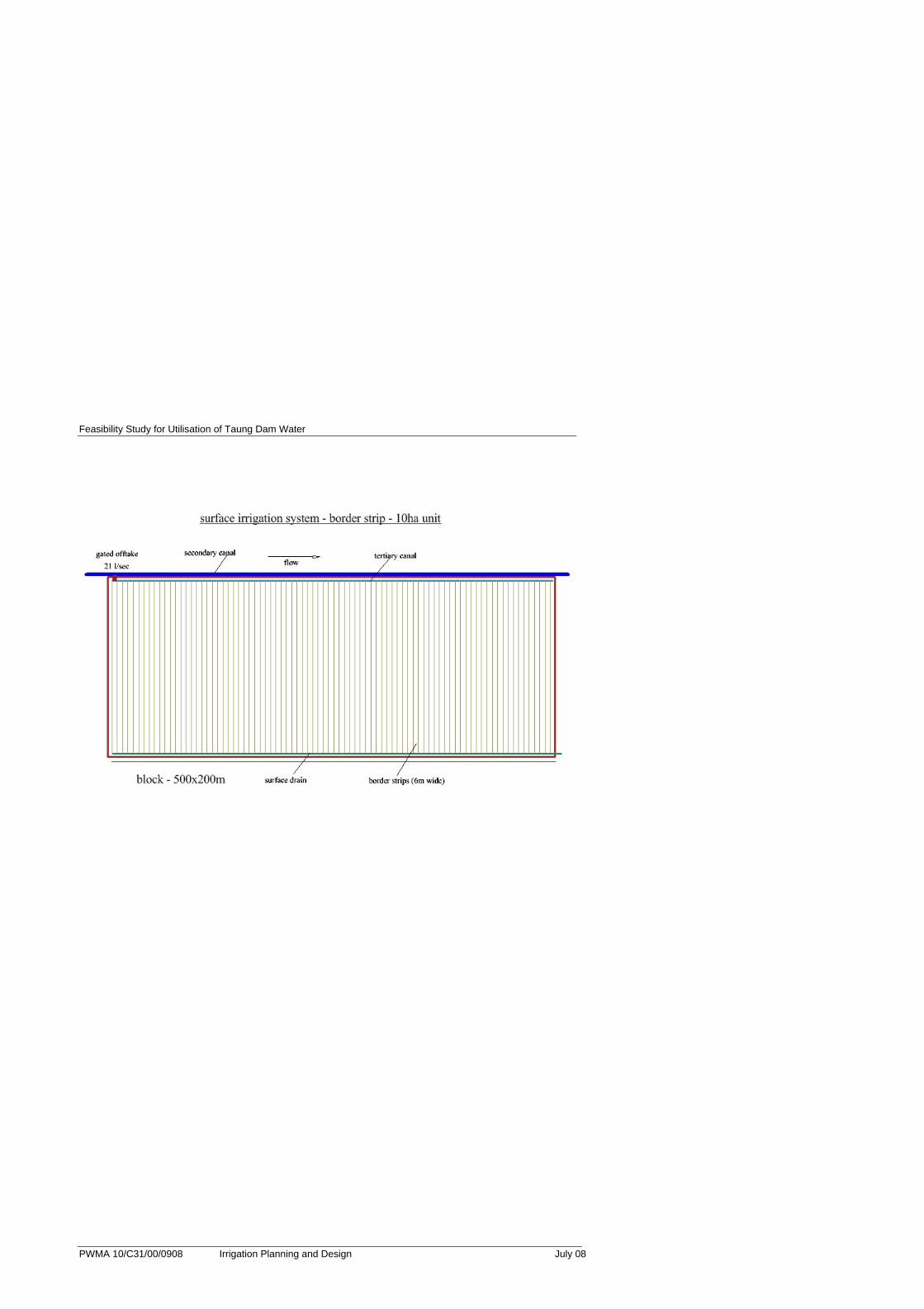
The suggested layouts of the various irrigation systems are shown in Annexure D. It
should be noted that the 10 Ha sprinkler and border strip blocks have the same
dimensions (500 x 200m) so only border strip blocks are shown – together with centre
pivots. The layouts demonstrate the difficulty of fitting the pivot circles into the same
areas of land that the rectangular border strip and sprinkler blocks occupy.
Drip irrigation was not considered owing to its high capital cost (+/-R 25 000/Ha) and
the complexity of the system – requiring a high level of management and/or
supervisory input.
4.1. Water Availability
The study has revealed that Taung Dam would be fully subscribed in the provision of
domestic and other primary water users. The study has also revealed that additional
water is available for Taung Irrigation Scheme expansion - it also being sourced via the
Vaalharts main canal and balancing dams.
This irrigation study therefore assumes that water will eventually be supplied to the
175 farmers for their 1 750 Ha via Vaalharts at the scheduled rate of 8 417 m³ per
hectare, or 14 729 750 m³ in total.
The type of irrigation employed would depend largely on the factors previously
mentioned – including capital cost, operating cost, ease of use, and efficiency
potential.
Feasibility Study for Utilisation of Taung Dam Water 5.1
PWMA 10/C31/00/0908 Irrigation Planning and Design July 08
5. COSTING
The operating costs of the three irrigation systems were calculated. These are shown
below. It should be noted that sprinkler has the highest costs in terms of Rand per
millimetre applied, and border strip the highest water duty requirement.
With respect to capital costs, the cost per hectare for centre pivot is about R12 000 and
sprinkler about R10 000. Border strip will rely on careful land levelling using laser
guided equipment, costs depending on the state of the land at present. Ridge forming
will be a further minor cost. A total cost per hectare of about R8 000 can be expected
for border strip.
Table 6: Taung Small Farmer Irrigation Plot Operating Costs
Irrigation System
Area (ha)
Maximum Water Duty
(24h) (I/sec/ha)
Maximum Water Duty (10h)
(I/sec/ha)
Flow required at field edge
(I/sec)
Annual Power
Requirement (kWh)
Cost of Irrigation (R/ha/an)
Cost of Irrigation (R/mm)
No. Man-days
Per ha Per
Annum (#)
(maize/barley)
Centre Pivot
4.5 0.98 8 13,038 1,922 1.04 280
(Per Farmer)
4 6,519 1,922 1.04 140
Sprinkler 4.2 0.98 4 15,583 2,265 1.38 280
Border Strip
3.6 0.98 1.96 20 0 1.172 0.59 280
Notes:
The centre pivots are costed as a single 20 Ha machine. However, each unit will accommodate two farmers of 10 Ha each.
Assumptions
1000m of mainline at friction losses of 1m/100m. 3m static head from pump station to fields (pivot extra 2m).
Cost of water 5c/m³ Cost of electricity 33c/kWh
All border strip lands are under command of a secondary canal.
Feasibility Study for Utilisation of Taung Dam Water 6.1
PWMA 10/C31/00/0908 Irrigation Planning and Design July 08
6. FINANCIAL ANALYSIS
Given the above information a financial analysis was undertaken on the selected
enterprises and on the different irrigation types proposed. The selected enterprises
include:
• Maize
• Barley (in rotation with maize)
• Lucerne
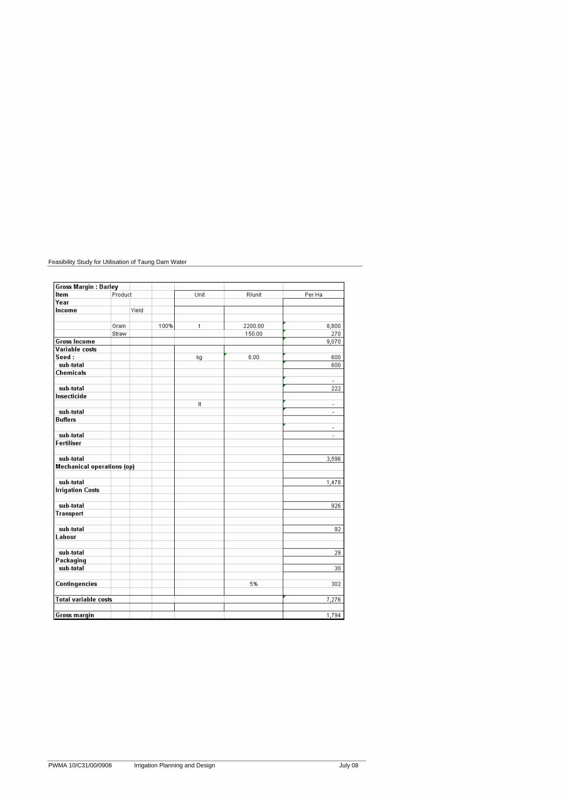
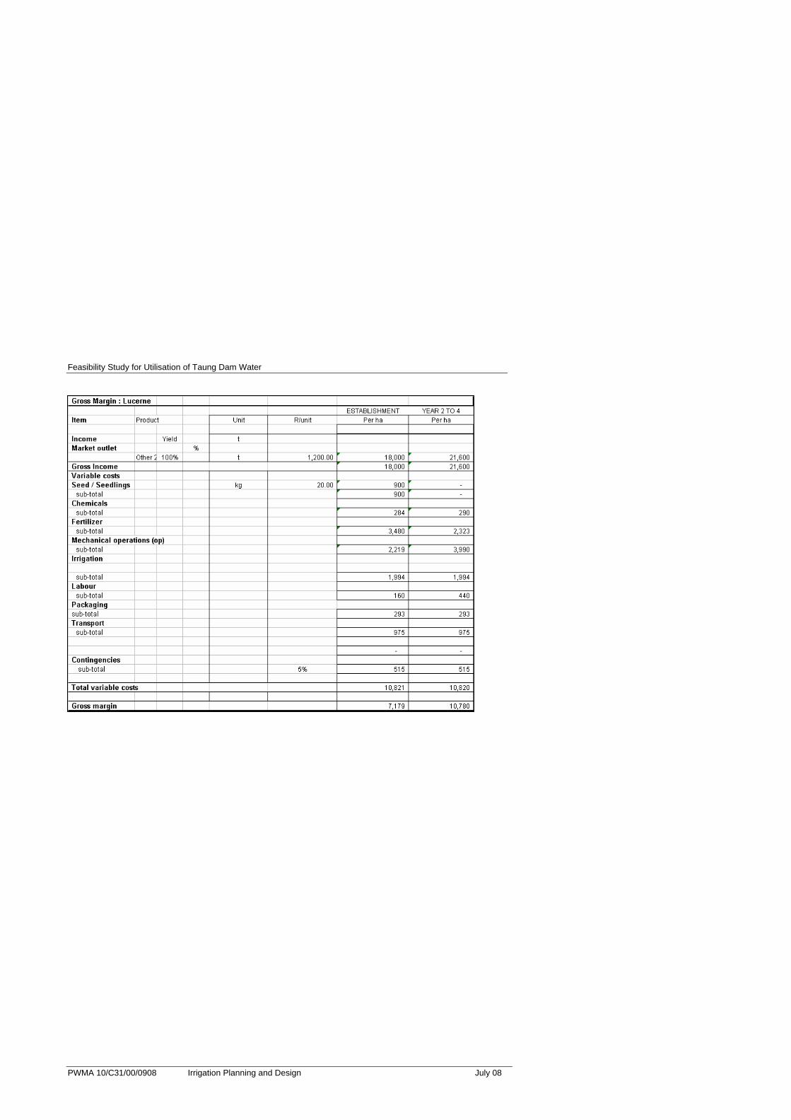
6.1. Gross Margins
A production programme for the selected enterprises was compiled. From these
production programmes gross margins for the selected enterprise were estimated.
Gross margins represent income from the sale of the crop less all direct costs that
can be allocated to the production of the specific enterprise. The main assumptions
for the gross margins are as follows:
• The gross margins are based on an average farmer in the area and attempt to
be representative of a typical farming operation in the region. However in
reality, there is a wide range of expertise and experience in farming which
results in a wide variation in actual income and costs of enterprises.
• Gross income is based on representative yields and a long-term price projection
for the enterprise.
• The gross margin costs include:
- input costs such as seed, chemicals and fertilizer,
- contract mechanical operations such as ploughing and spraying,
- all directly allocated labour costs
- transport costs,
- packaging costs,
- a contingency amount of 5% of total costs to allow for miscellaneous
expenses.
A summary of the gross margin for the selected crops is given in Table 7. A detailed
Gross Margin analysis for the selected enterprises is given in Annexure F.

Feasibility Study for Utilisation of Taung Dam Water 6.2
PWMA 10/C31/00/0908 Irrigation Planning and Design July 08
Table 7: Summary Gross Margin for Selected Enterprises
Maize Barley Lucerne (Est.)
Lucerne (2 – 5 years)
R/ha (Sprinkler Irrigation)
Price (R/ton) 1 800 2 200 1 200 1 200
Yield (tons) 10 4 15 18
Gross Income 18 000 9 070 (+ straw) 18 000 21 600
Variable Cost 11 535 7 276 10 821 10 820
Gross Margin 6 465 1 794 7 179 10 780
The above table indicates that lucerne has the highest return, however it is more
capital intensive as the establishment costs are relatively high. The next step in the
analysis is to develop farmer models.
6.2. Farmer Model
Different farmer models have been compiled for the selected rotations for the
different irrigation models. The main cost driver from the irrigation types has been
taken from Table 6. The areas that can be cropped for each enterprise assuming
optimum irrigation requirements are also taken from Table 6. The main assumptions
of the models are as follows:
• The farm models are estimated over a 10 year period
• The models are undertaken in constant 2008 Rand values
• It is assumed that the farm will be developed in the first year of operations.
• 20% of lucerne is re-established every year
• Water cost (tariff) included
• No finance (interest) costs included
• Income and production costs are derived from the gross margin estimates.
• All initial capital costs are included
• Overhead costs have been estimated for each farmer model and included in the
analysis. These include management salaries, general repairs, bank charges,
auditing fees etc. These have been standardised across the enterprise and
Feasibility Study for Utilisation of Taung Dam Water 6.3
PWMA 10/C31/00/0908 Irrigation Planning and Design July 08
irrigation types so that the result of the model will reflect enterprise and irrigation
type efficiency.
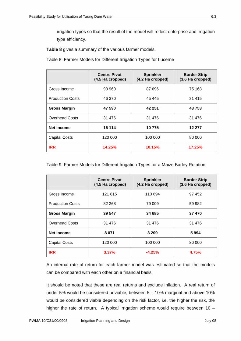
Table 8 gives a summary of the various farmer models.
Table 8: Farmer Models for Different Irrigation Types for Lucerne
Centre Pivot (4.5 Ha cropped)
Sprinkler (4.2 Ha cropped)
Border Strip (3.6 Ha cropped)
Gross Income 93 960 87 696 75 168
Production Costs 46 370 45 445 31 415
Gross Margin 47 590 42 251 43 753
Overhead Costs 31 476 31 476 31 476
Net Income 16 114 10 775 12 277
Capital Costs 120 000 100 000 80 000
IRR 14.25% 10.15% 17.25%
Table 9: Farmer Models for Different Irrigation Types for a Maize Barley Rotation
Centre Pivot (4.5 Ha cropped)
Sprinkler (4.2 Ha cropped)
Border Strip (3.6 Ha cropped)
Gross Income 121 815 113 694 97 452
Production Costs 82 268 79 009 59 982
Gross Margin 39 547 34 685 37 470
Overhead Costs 31 476 31 476 31 476
Net Income 8 071 3 209 5 994
Capital Costs 120 000 100 000 80 000
IRR 3.37% -4.25% 4.75%
An internal rate of return for each farmer model was estimated so that the models
can be compared with each other on a financial basis.
It should be noted that these are real returns and exclude inflation. A real return of
under 5% would be considered unviable, between 5 – 10% marginal and above 10%
would be considered viable depending on the risk factor, i.e. the higher the risk, the
higher the rate of return. A typical irrigation scheme would require between 10 –

Feasibility Study for Utilisation of Taung Dam Water 6.4
PWMA 10/C31/00/0908 Irrigation Planning and Design July 08
12% IRR (at least) depending on assumptions (i.e. costs) included in the financial
model.
Feasibility Study for Utilisation of Taung Dam Water 7.1
PWMA 10/C31/00/0908 Irrigation Planning and Design July 08
7. CONCLUSION
As a result of the higher capital costs and pumping costs centre pivot and sprinkler
irrigation are less viable than border strip irrigation. Border strip irrigation is more
viable even if it is on a smaller area. In terms of water use efficiency this is taken into
account in financial terms as the model assumes that 10 Ha is costed (water tariff),
however only 3.6 Ha is cropped. In terms of enterprises lucerne is more viable than
the maize/barley rotation however it is more capital intensive. For resource poor
farmers the maize barley rotation may be more affordable. It should be noted that
maize grown on its own is not a viable option.
Feasibility Study for Utilisation of Taung Dam Water
PWMA 10/C31/00/0908 Irrigation Planning and Design July 08
ANNEXURE A
MAP OF POTENTIAL IRRIGABLE AREAS
Feasibility Study for Utilisation of Taung Dam Water
PWMA 10/C31/00/0908 Irrigation Planning and Design July 08
Feasibility Study for Utilisation of Taung Dam Water
PWMA 10/C31/00/0908 Irrigation Planning and Design July 08
ANNEXURE B
MONTHLY WATER REQUIREMENTS FOR THREE IRRIGATION SYSTEMS AND FOR TWO CROP ROTATIONS
Feasibility Study for Utilisation of Taung Dam Water
PWMA 10/C31/00/0908 Irrigation Planning and Design July 08
Feasibility Study for Utilisation of Taung Dam Water
PWMA 10/C31/00/0908 Irrigation Planning and Design July 08
Feasibility Study for Utilisation of Taung Dam Water
PWMA 10/C31/00/0908 Irrigation Planning and Design July 08

Feasibility Study for Utilisation of Taung Dam Water
PWMA 10/C31/00/0908 Irrigation Planning and Design July 08
Feasibility Study for Utilisation of Taung Dam Water
PWMA 10/C31/00/0908 Irrigation Planning and Design July 08

Feasibility Study for Utilisation of Taung Dam Water
PWMA 10/C31/00/0908 Irrigation Planning and Design July 08
Feasibility Study for Utilisation of Taung Dam Water
PWMA 10/C31/00/0908 Irrigation Planning and Design July 08
ANNEXURE C
TYPICAL LAYOUTS FOR 3 IRRIGATION SYSTEMS
Feasibility Study for Utilisation of Taung Dam Water
PWMA 10/C31/00/0908 Irrigation Planning and Design July 08
Feasibility Study for Utilisation of Taung Dam Water
PWMA 10/C31/00/0908 Irrigation Planning and Design July 08
Feasibility Study for Utilisation of Taung Dam Water
PWMA 10/C31/00/0908 Irrigation Planning and Design July 08
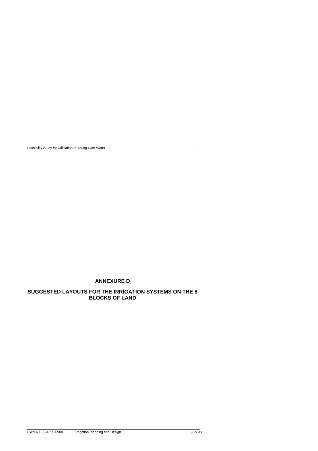
ANNEXURE D
SUGGESTED LAYOUTS FOR THE IRRIGATION SYSTEMS ON THE 8 BLOCKS OF LAND
Feasibility Study for Utilisation of Taung Dam Water
PWMA 10/C31/00/0908 Irrigation Planning and Design July 08
Feasibility Study for Utilisation of Taung Dam Water
PWMA 10/C31/00/0908 Irrigation Planning and Design July 08

Feasibility Study for Utilisation of Taung Dam Water
PWMA 10/C31/00/0908 Irrigation Planning and Design July 08
Feasibility Study for Utilisation of Taung Dam Water
PWMA 10/C31/00/0908 Irrigation Planning and Design July 08
Feasibility Study for Utilisation of Taung Dam Water
PWMA 10/C31/00/0908 Irrigation Planning and Design July 08
Feasibility Study for Utilisation of Taung Dam Water
PWMA 10/C31/00/0908 Irrigation Planning and Design July 08
Feasibility Study for Utilisation of Taung Dam Water
PWMA 10/C31/00/0908 Irrigation Planning and Design July 08

Feasibility Study for Utilisation of Taung Dam Water
PWMA 10/C31/00/0908 Irrigation Planning and Design July 08
ANNEXURE E
SOIL ANALYSIS RESULTS
Feasibility Study for Utilisation of Taung Dam Water
PWMA 10/C31/00/0908 Irrigation Planning and Design July 08

Feasibility Study for Utilisation of Taung Dam Water
PWMA 10/C31/00/0908 Irrigation Planning and Design July 08
ANNEXURE F
GROSS MARGINS
Feasibility Study for Utilisation of Taung Dam Water
PWMA 10/C31/00/0908 Irrigation Planning and Design July 08
Feasibility Study for Utilisation of Taung Dam Water
PWMA 10/C31/00/0908 Irrigation Planning and Design July 08
Feasibility Study for Utilisation of Taung Dam Water
PWMA 10/C31/00/0908 Irrigation Planning and Design July 08