Embed Size (px)
Citation preview

Department of Water Affairs and Forestry
Republic of South Africa
A GUIDE TO VERIFYING THE EXTENT OF EXISTING LAWFUL WATER USE
Edition 2.1 November 2006
A Guide to Verification
Edition 2.1 i November 2006
EXECUTIVE SUMMARY
Background The definition of existing lawful water use (ELU), and the process of verifying the extent ELU is outlined in Sections 32 to 35 of the National Water Act (Act 38 of 1998 - NWA). These sections make provision for water use that was lawful under previous laws, and which was exercised during a qualifying period, to continue until such time as the use can be replaced by a licence under the NWA. This is an important step in the process of realising the goals of the NWA. More specifically, Section 35 of the NWA includes provisions for a Responsible Authority to determine the extent of ELU. This Guide to verifying the extent of existing lawful water use outlines procedures for implementing Section 35. It places specific emphasis on a fair, reasonable and just process, but recognises the need to spend government resources wisely, and the need to speed up the process. It is, nevertheless, recognised that different approaches may be required under different circumstances. This Edition 2 of the Guide is based on the experiences gained in a number of studies around the country. The legislative provisions Section 4(4) of the NWA replaces the water rights under old legislation, with entitlements under the new legislation. However, existing water uses were allowed to continue as “existing lawful water use”. The following provisions of the NWA define and limit the extent of this entitlement; � Section 32 defines existing lawful use as a water use that was lawfully undertaken
during a two-year period immediately before the date of commencement of the Act. � Section 33 allows for the declaration of any water use not considered under Section 32,
as an existing lawful use. � Section 34 provides the authority to continue with an existing lawful use until its
replacement by a licence. � Section 35 outlines provisions for persons claiming an existing lawful use entitlement, to
apply for the verification of the extent of existing lawful use. Water users may not continue to use the water if they do not apply for verification when requested to do so, or if the verification application has been refused.
� The responsible authority can also conduct its own investigation into the veracity of the claims made. This Guide outlines how this investigation could be done.
The registration process The process of verification started with the registration process. Registration was done to capture a database of water use and to serve as a basis for water resource management charges. Government Notice 1352, placed in the Government Gazette of 12 November 1999 required all water users to register their water use as exercised at that time. Group registrations by WUAs or Irrigation Boards was allowed, but a more recent policy decision has indicated that each individual user should be registered. During registration many irrigation users had little idea of the volume of water used, and water use was calculated using the SAPWAT model based on the crops, areas, and type of irrigation system as specified in the registration forms. However, SAPWAT was not applied uniformly, and was not used in some areas. In addition, in many cases irrigation users disputed the initial figures, and the results were (and are still being) adjusted to provide “acceptable” figures. It is likely that, in many cases, this process was driven more by the financial burden of the water resource charge, and not on providing a more accurate picture of actual water use. Water users have been paying water resource management charges on the basis of the final registration figures. As such, these figures have a measure of acceptability to the users. Moreover, Government Notice 1352 indicated that the information provided in the registration

A Guide to Verification
Edition 2.1 ii November 2006
forms would be used to determine the lawfulness of existing water use. The information in WARMS should therefore be used as a basis for the verification process. The verification process Verification aims to collate the following information for each property where water use is identified;
� The cadastral data relating to the property, � The registered use (volumes, irrigation systems, crops and hectares), � The use in the qualifying period (volumes, crops, irrigation systems and hectares), and � Whether any previous legislation would have limited the historical use. � Additional data covering a longer period of potential water use is required if these data
are to be used as a basis for water availability assessments. This process is best done on a GIS database. The cadastral from the Surveyor-General’s office data should be updated based on the Deeds office data (these data are available from the Directorate: Business Information). The WARMS data can then be linked to a specific property on the database. Irrigation and forestry areas are determined by satellite imagery, and LANDSAT is recommended as a point of departure. Often several images are needed to accurately determine areas of irrigation. In these cases the maximum area noted during the qualifying period is accepted as the use in the qualifying period. Particular care must be taken if areas are double or triple cropped. Use by non-land based activities (Municipal, Industrial and Mining) can usually be determined from data collected by these users. The storage volume per property can also be determined from satellite imagery. If users dispute either the areas, or storage volumes, they should be asked provide additional information at their costs. Irrigation water use in the qualifying period should be estimated by multiplying the application rate (in m3/ha/a) as determined from the WARMS data with the area under irrigation as determined from the satellite imagery. However, fair, reasonable and justifiable proposals of the extent of ELU in the qualifying period can also be made by;
1. Using a standard application rate(s) determined by agricultural experts to be justifiable for that area.
2. Using the application rates for nearby scheduled areas. 3. Using the application rates from neighbours who have accurately determined water use. 4. Applying any previous Water Court orders to the use in the qualifying period. 5. Applying a fair share principle were the calculated use in the qualifying period exceeds
the available water.
For scheduled areas, the full scheduled and paid for volume of water is considered lawful. As such, dormant but paid for water is considered as part of ELU. Payments refer to any payments of water required under previous legislation, and not to the water resource management charges. Working with stakeholders The determination the extent of existing lawful water use is not only a legal technical process, particularly as the actual volume irrigated in the qualifying period has to be inferred from the area under irrigation. The proposals made in this Guide are based on “agreeing” fair, reasonable and justifiable ELU with stakeholders. The following procedure is recommended if the process is limited to verification. This process minimises the time and resources required for verification, but does not provide all the data required for water availability assessments (although baseline data are still available for later studies).
1. Cadastral data, and areas under irrigation (from Landsat and any readily available remote sensing platform providing more accurate data) must be determined, and compared to the latest data from WARMS for each property. Field boundaries should as far as possible be determined from orthophotos or actual surveyed data.

A Guide to Verification
Edition 2.1 iii November 2006
2. Current, qualifying period and registered water use as both areas and volumes should be collated, and fair and justifiable determinations of proposed existing lawful use made based on the WARMS data, and best available areas under irrigation. This should be done internally by the responsible authority. Water use includes determining the volume of storage on each property.
3. The data on the registration forms must be used as a basis for determining the volume of water irrigated per hectare, and the remotely sensed data is used to confirm the area under irrigation in the qualifying period. The volume of storage must be determined using the formulae included in Appendix D.
4. Where previous legislation may have limited the volume irrigated or stored, these determinations must be used.
5. All existing water users should be given notice of the intention to determine the proposed extent of existing lawful use in the catchment.
6. This notice should also invite users to a meeting / workshop to discuss the process, and the data made available to all interested parties and/or published by irrigation boards and WUAs.
7. The workshop should start by explaining the verification process, and how existing lawful use was determined, highlighting the assumptions made in determining proposed existing lawful water use. These assumptions could be;
• Satellite determinations of areas under irrigation are accurate.
• The registration on WARMS for that property is correct.
• The use has been linked to the correct cadastral property.
• Water use on sub-divisions of the property since the qualifying period are proportional to the original total use for the property.
• Site specific assumptions for particular users. 8. Users should be given a reasonable time to respond to or challenge these assumptions.
This must be done in writing, providing additional information addressing the assumptions made – and indicating why these are not applicable to their use.
9. After considering these objections, the Responsible Authority can finalise the tables. 10. All existing users should then be invited to apply for verification (Section 35[1 & 2])
based on the updated tables. This notification must be sent as registered mail to each user – including the updated estimation of proposed ELU for their specific use. Suitable application forms must accompany this notification. Users can also be told that the full tables are available for inspection.
11. Comments should be invited from all interested parties (Section 35[3c]). 12. Existing users may further dispute the figures outlined (Section 35[3d]), and in this case
could be requested to provide additional information at their cost to back up their claims (Section35[3a]).
13. The users should be given a reasonable time to respond, and once all the applications and responses have been evaluated, a certificate outlining the extent of existing lawful use on each property can be issued. (Section 35[4])
14. This determination will limit the extent of existing lawful use identified under Section 32(1), and as such agreements must be made on how the user will curtail his/her use to these levels (Section 35[5]).
15. Where users are currently using water unlawfully, the Responsible Authority must issue a directive to the user to stop the water use (Section 53), and may consider further actions under Sections 151-153 of the NWA.

A Guide to Verification
Edition 2.1 iv November 2006
The following procedure is recommended if the verification process is to be used as a basis for water resource availability models; (This process is more resource intensive, and time consuming).
1. Cadastral data, and areas under irrigation must be determined from Landsat data supported by accurate field boundaries. This should be done for 4 time horizons.
2. The SAPWAT model should be calibrated for each cadastral property for the full period of data available, and monthly water use and return flow data calculated. The same rainfall sequences should be used to calculate runoff in the WRSM2000 model.
3. Agricultural water use experts familiar with the area should be used support the calibration of the SAPWAT model.
4. If actual measured water use data are available for some users, these should be used to validate the determinations for other water users. These data should be provided in a format required by the water availability models.
5. Storage volumes and areas must be determined and provided in the format required by the water availability models.
6. Where previous legislation may have limited the volume irrigated or stored, these determinations must be included in the database.
7. All existing water users should be given notice of the intention to determine the proposed extent of existing lawful use in the catchment.
8. This notice should also invite users to a meeting / workshop to discuss the process, and the data made available to all interested parties and/or published by irrigation boards and WUAs.
9. The workshop should start by explaining the verification process, and how existing lawful use was determined, highlighting the assumptions made in determining proposed existing lawful water use. These assumptions could be;
• Assumptions used to calibrate the SAPWAT model are applicable to each property – including those where users have farmed less “scientifically”.
• The use has been linked to the correct cadastral property.
• Water use on sub-divisions of the property since the qualifying period are proportional to the original total use for the property.
• Site specific assumptions for particular users. 10. Users should be given a reasonable time to respond to or challenge these assumptions.
This must be done in writing, providing additional information addressing the assumptions made – and indicating why these are not applicable to their use.
11. After considering these objections, the Responsible Authority can finalise the tables. 12. All existing users should then be invited to apply for verification (Section 35[1 & 2])
based on the updated tables. This notification must be sent as registered mail to each user – including the updated estimation of proposed ELU for their specific use. Suitable application forms must accompany this notification. Users can also be told that the full tables are available for inspection.
13. Comments should be invited from all interested parties (Section 35[3c]). 14. Existing users may further dispute the figures outlined (Section 35[3d]), and in this
case could be requested to provide additional information at their cost to back up their claims (Section35[3a]).
15. The users should be given a reasonable time to respond, and once all the applications and responses have been evaluated, a certificate outlining the extent of existing lawful use on each property can be issued. (Section 35[4]).
16. This determination will limit the extent of existing lawful use identified under Section 32(1), and as such agreements must be made on how the user will curtail his/her use to these levels (Section 35[5]).
17. Where users are currently using water unlawfully, the Responsible Authority must issue a directive to the user to stop the water use (Section 53), and may consider further actions under Sections 151-153 of the NWA.

A Guide to Verification
Edition 2.1 v November 2006
TABLE OF CONTENTS EXECUTIVE SUMMARY............................................................................................................. i 1 INTRODUCTION ....................................................................................................................1
1.1 Background................................................................................................................ 1
1.2 The legislative provisions ......................................................................................... 1
1.3 The registration process ........................................................................................... 3
1.4 What is Verification? ................................................................................................. 3
1.5 What is the purpose of this Guide?.......................................................................... 4
2 THE VERIFICATION PROCESS ............................................................................................5
2.1 Background................................................................................................................ 5
2.2 The Cadastral & Deeds data ..................................................................................... 5
2.3 Interrogating the WARMS database ......................................................................... 6
2.4 Determining the use in the qualifying period .......................................................... 8
2.4.1 Estimating areas of irrigation or under trees ................................................................8
2.4.2 Estimating the volumes of dams................................................................................10
2.4.3 Verifying water use for users scheduled under the old Water Act.........................11
2.4.4 Determining the volume of water irrigated outside of GWCAs..............................11
2.4.4 Determining the proposed extent of existing lawful water use ..............................13
2.4.5 Determining current water use .............................................................................14
2.4.6 Verification in support of water availability assessments ......................................16
3 WORKING WITH STAKEHOLDERS TO UNDERTAKE VERIFICATION (S35) ........ 16
APPENDIX A – The qualifying period.....................................................................................20
APPENDIX B Calculating the “fair share principle” for areas outside of government
water control areas. ............................................................................................................21
APPENDIX C: Reasons for individual registrations and licensing.......................................23
APPENDIX D: Recommended methods for determining the volumes of storage...............24
APPENDIX E: REQUIREMENTS FOR USING VERIFICATION IN SUPPORT OF WATER
AVAILABILITY ASSESSMENT STUDIES............................................................................25

A Guide to Verification
Edition 2.1 1 November 2006
1 INTRODUCTION
1.1 Background The definition of existing lawful water use (ELU), and the process of verifying the extent ELU for each water user is outlined in Sections 32 to 35 of the National Water Act (Act 38 of 1998 - NWA). These sections make provision for water use that was lawful under previous laws, and which was exercised during a qualifying period, to continue until such time as the use can be replaced by a licence under the NWA. Licences issued under the NWA must give effect to the purpose of the Act as outlined in Section 2, including a commitment to race and gender transformation and meeting the needs of the Reserve. The verification of the extent of existing lawful water use is, therefore, an important step in the process of realising the goals of the NWA. Verification serves as the bridge between the old Water Act of 1956, and the NWA and is a necessary step in converting water use authorised under the previous laws, into a licence under the new legislation. It is therefore required before any water trading arrangements can be effected, or before the compulsory licensing process can be implemented. Stakeholders may also wish to have water use verified before buying or selling a property. More specifically, Section 35 of the NWA includes provisions for a Responsible Authority1 to determine the extent of ELU with users. This Guide provides guidelines on how Section 35, or verification, process, should be implemented. It places specific emphasis on a fair, reasonable and just process. But also recognises the need to use resources and funds wisely. Moreover, this process also recognises the need to speed up the water allocation reform process, and hence to facilitate the verification process. A shorter, yet legally defensible and transparent and open process with stakeholders is therefore proposed. The Guide is specifically aimed at verifying the extent of ELU on a catchment wide basis as part of the compulsory licensing process. However, verification may also be used as part of other processes, such as the development of water resources availability models, or to help address unlawful water use in a specific area. Verification may also be done on an individual basis, to confirm the extent of ELU on a property that is being sold, or if the water use is going to be subject to a trade. This may demand different approaches to those outlined here. A more detailed, resource intensive process is therefore also proposed where the verification process is being used to support water availability modelling.
1.2 The legislative provisions One of the key principles behind the allocation of water in the NWA is the decoupling of land and water. Previously land and water were linked, and ownership of land conveyed rights to the water flowing alongside, through or under the land. However, the NWA makes the Minister of Water Affairs and Forestry the custodian of the water resource, and water users only have an entitlement to use water for a given period, even if this water is found on their own property. This is because all water is linked in a single water cycle, and water found on one property is linked to other water in the same system.
1 A responsible authority is either the CMA, or DWAF. As such, verification can be delegated to
a CMA level. At present the delegation for Section 35 declarations is Chief Director: Regional Offices
A Guide to Verification
Edition 2.1 2 November 2006
Allowing this water to be used elsewhere in the wider system may be more beneficial to the nation as a whole. Section 4(4) of the NWA therefore replaces the water rights under old legislation, with entitlements under the new legislation. However, as it was impractical to re-license all water users when the NWA was promulgated, existing water uses were allowed to continue as a special entitlement viz. “existing lawful water use”. The following provisions of the NWA define and limit the extent of this entitlement;
� Section 32 defines existing lawful use as a water use that was lawfully
undertaken during a two-year period immediately before the date of commencement of the Act (i.e. the qualifying period – See Appendix A).
� Section 33 allows for the declaration of any water use not considered under Section 32, as an existing lawful use, provided that it took place in the qualifying period, but was discontinued for good reason. Or did not take place in the qualifying period but would been lawful if it had taken place, and reasonable steps towards effecting this use had been taken.
� Section 34 provides the authority to continue with an existing lawful use until its replacement by a licence2.
� Section 35 outlines provisions for persons claiming an entitlement as an existing water use, to apply for the verification of the extent of existing lawful use. This can be done on request from the responsible authority for all, or some of, the users in a geographic area. This section allows the water user to raise appeals to the Water Tribunal if they are not satisfied with the outcome of the process, as well as the opportunity for anyone affected by the process to provide input3.
� Section 35 also indicates that persons may not continue to use the water if they do not apply for verification when requested to do so, or if the verification application has been refused.
� The responsible authority can also conduct its own investigation into the veracity of the claims made. This Guide outlines how this investigation should be done.
2 This will be done during compulsory licensing, but trading of an existing lawful water use also
converts the use to a licence. New licences are issued subject to the conditions in the NWA, and in particular Section 27. 3 This could include new licence applicants who have been told that there is no water available.
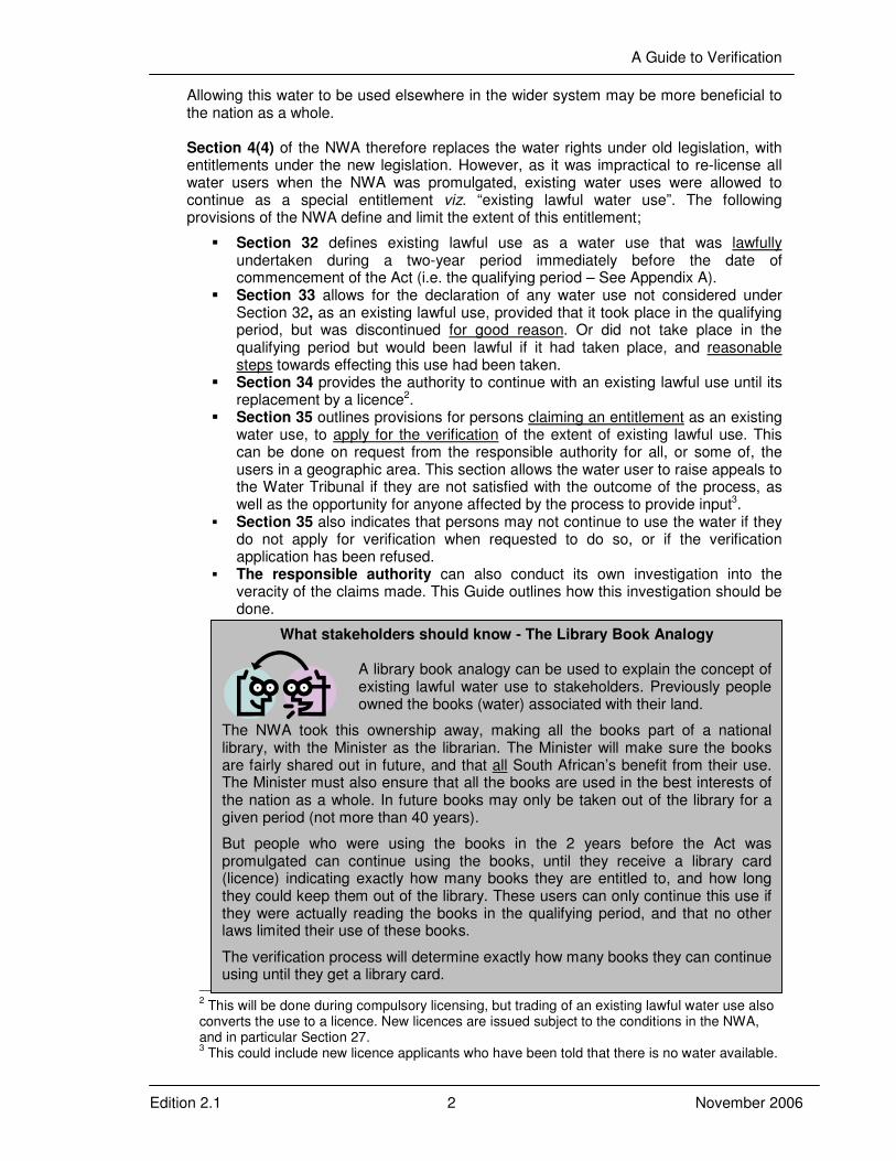
What stakeholders should know - The Library Book Analogy
A library book analogy can be used to explain the concept of existing lawful water use to stakeholders. Previously people owned the books (water) associated with their land.
The NWA took this ownership away, making all the books part of a national library, with the Minister as the librarian. The Minister will make sure the books are fairly shared out in future, and that all South African’s benefit from their use. The Minister must also ensure that all the books are used in the best interests of the nation as a whole. In future books may only be taken out of the library for a given period (not more than 40 years). But people who were using the books in the 2 years before the Act was promulgated can continue using the books, until they receive a library card (licence) indicating exactly how many books they are entitled to, and how long they could keep them out of the library. These users can only continue this use if they were actually reading the books in the qualifying period, and that no other laws limited their use of these books. The verification process will determine exactly how many books they can continue using until they get a library card.

A Guide to Verification
Edition 2.1 3 November 2006
1.3 The registration process
The process of determining the extent of ELU started with the registration process. The primary aim of registration was to capture a database of water use to serve as a basis for water resource management charges. Government Notice 1352, placed in the Government Gazette of 12 November 1999 therefore required all water users to register their water use as exercised at that time. Importantly, therefore registration actually required users to indicate their use 2-3 years after the qualifying period. The registration process in each province started in 2000, and is still ongoing, as some users re-register changed use, or deregister water use no longer practiced. The registered water use is captured in the DWAF’s Water Authorisation and Registration Management System (WARMS). Importantly, however, during registration many irrigation users had little idea of the volume of water used, and in these cases the water use had to be calculated based on the crops, areas, and type of irrigation system as specified in the registration forms. The pricing strategy specified that the SAPWAT model should be used to determine the volumes of water used for determining the water resource management charges. This model was therefore used in most areas around the country, with the exception of some areas, notably the Western Cape. Water managers in the Western Cape argued that the SAPWAT model did not provide accurate estimates of water use. Moreover, the SAPWAT model was not used uniformly over the whole country. However, in many cases irrigation users disputed the initial figures outlined in their Registration Certificates, and the results were often adjusted to provide “acceptable” figures. It is likely that, in many cases, this process was driven more by the financial burden of the water resource charge, and not necessarily on providing a more accurate picture of actual water use. This process is still continuing, and regional DWAF offices respond to applications from water users. The WARMS database is therefore constantly under revision, largely at the discretion of the various regional offices. Water users have, nevertheless, been ( and are still) paying water resource management charges on the basis of the latest WARMS figures. As such, these figures have a measure of acceptability to the users. Moreover, Government Notice 1352 indicates that;
“6 (1) The extent or lawfulness of the relevant water use will be determined on the basis of the information supplied in the application forms. The responsibility is with the water user to ensure the correctness of all information.”
Registration data could therefore be used as a basis for the verification process.
1.4 What is Verification? This Guide describes the processes required to;
� Firstly, compare the current and qualifying period water use to that which was
registered in the WARMS system, i.e. Validation, and � Secondly, to determine the extent of water use that the user is lawfully entitled to,
i.e. Verification.
A Guide to Verification
Edition 2.1 4 November 2006
Validation confirms how much water the user was actually using in the qualifying period, how much they said they were using in 2000 (or Registered)4, as well as how much they are currently using. Validation is not defined in the NWA, and is in fact only a step in the verification process. Most importantly, in the absence of actual measured water use data, any determination of water use in the qualifying period is by proxy. The appropriate proxy to use depends on a variety of factors including costs, the purpose of verification, assumptions to be made and legal justifiability. It would, therefore, not be appropriate to update the WARMS database on the validation data, as these data are based on untested assumptions. Verification determines the extent of existing lawful water use. This process confirms if any previous laws would have limited the use in the qualifying period. If not, the use in the qualifying period is lawful. Previous laws include Water Court orders apportioning the water, agreements between users, customary law5, or the “fair share of the normal flow” principle. The calculation of the fair share principle is described in Appendix B. This process can be very time and resource hungry. More importantly, Section 35 requires that water users claiming an existing lawful water use entitlement to apply for the verification of that use. The responsible authority may require the applicant to provide additional information [S35 (3)a], or may conduct its own investigation [S35 (3)b]. This latter provision is necessary to avoid simply repeating the Registration process, but in effect these two provisions allow the applicant and responsible authority – in the absence of accurate and reliable determinations of actual use in the qualifying period – to agree on fair, reasonable and legally justifiable determinations within the ambit of Sections 32 and 33. Directives may then be issued to water users to stop that portion of their current use that is unlawful. A separate guideline document which outlines how this should be done is also available to guide regional offices in taking appropriate steps to address unlawful use.
1.5 What is the purpose of this Guide?
Edition 1 of the Guide to Determining Existing Lawful Water Use recommended the use of the SAPWAT model on satellite-derived data from the qualifying period to determine the extent of existing lawful water use for irrigation users. That guide has been tested in a number of catchments, and these experiences have indicated that routine application of the SAPWAT model was expensive, time consuming, and often yielded modelled water use figures that exceeded the water available. Moreover, it became clear that while SAPWAT was a good basis for a pricing strategy, it did not necessarily provide an accurate and reliable indication of historical water use. Be this as it may, the calibration of the SAPWAT model for some users in the Mokolo catchment has shown very good correlation of measured monthly water use with modelled water use. However, irrigation users accurately measuring their water use would tend to be more scientific in the irrigation applications, and one may therefore expect a good correlation for these users. The extrapolation of these calibrations to users who may not have been as methodical with irrigation could be flawed.
4 It should be noted that registration asked for water use in 2000, but verification is based on
use between 1996 and 1998, or in some cases 1999. (see Appendix A). 5 See Constitution section 211(3)
A Guide to Verification
Edition 2.1 5 November 2006
It was therefore decided to revise Edition 1 of the Guide to outline a more practical approach that both recognised the need for urgent attention to determining the extent of existing lawful water use, and the limited resources available to the responsible authority. It was also decided (based on the experiences gained) that a participative approach with stakeholders might limit the problems of legal challenges to the determinations. Lastly, it was felt that the responsible authority could make proposed determinations based on information that is readily available and processed, but where water users disputed these results further studies should be done at the water users cost [See Section 35 (3) a]. As such, Edition 2 of the Guide aims for to determine a fair, reasonable and legally justifiable approach to verification. It accepts that the determination of ELU may not be based on an absolutely accurate determination of actual use in the qualifying period, but affords the opportunity for stakeholders to provide additional data and studies at their cost. In this sense, the ability of the process to stand up in the courts will be determined not necessarily by the accuracy of the answer, but by the fact that reasonable and justifiable estimates were made, but that users were given the opportunity to provide more detailed information for consideration. Stakeholders will also be given the opportunity to propose approaches that are fair to all users. However, in order for this process to work, stakeholders must be fully informed of the process, and of how the calculations of existing lawful use were made. The approach outlined in this Guide is therefore based on collective stakeholder participation in the process, rather than on interactions with individual water users. Separate awareness materials have therefore been developed to support this process. Guidelines are nevertheless still provided for a more detailed verification process primarily to support water availability assessments.
2 THE VERIFICATION PROCESS
2.1 Background
The intention of the verification process is to collate, preferably on a GIS, the following information for each property where water use is identified6; � The cadastral data relating to the property, � The registered use (volumes, irrigation systems, crops and hectares), � The use in the qualifying period (volumes, crops, irrigation systems and hectares, and � Whether any previous legislation would have limited the historical use.
However, the determination of historical water use in the absence of actual measured data has to be done by proxy. The approach outlined below therefore uses LANDSAT derived data on irrigation and forestry areas, together with the data available from the WARMS database to determine water use during the qualifying period.
2.2 The Cadastral & Deeds data
The cadastral data links the water use on the land to the property ownership (and hence to the lawful access to the land). The WARMS data is also based on the cadastral information and links the registered water use to a particular property. Any certificate of
6 This does not include properties using water under Schedule 1 of the National Water Act.

A Guide to Verification
Edition 2.1 6 November 2006
existing lawful use will also be linked to each property. It is therefore important to get up-to-date cadastral and deeds data at the start of the validation process.
Digital cadastral data can be obtained from the offices of the Surveyor-General, but experience has shown that the digital data sets are not always up to date, and may have to be cleaned from hard copy data before they can be linked to the WARMS data. The deeds information regarding the ownership of properties is obtained from the office of the Registrar of Deeds. Generally the Deeds data are more up to date than the cadastral data, and can therefore be used to clean up the cadastral data. In addition, in spite of a requirement to re-register water use should property details change, most users do not re-register and WARMS data may also be out of date. There are also areas in South Africa that have never been surveyed and cadastral data are not available – specifically in the ex-homeland areas of the country. Linking water use to property ownership in these areas could, therefore, prove to be problematic.
The Water Resources Information Management Chief Directorate is in the process of updating and cleaning the cadastral data for the whole country, and they should be approached first. However, additional work may have to be done at the start of the validation process to ensure reliable cadastral data. More importantly, land ownership changes continually and some changes to ownership will have taken place since the clean up of the data, and up-to-date deeds data will be required. This will be particularly important for sub-divisions of land, as the existing lawful water use entitlement would have to be divided among the present owners. The consolidation of properties will also result in the consolidation of water use entitlements.
It is consequently important to minimize the delays between acquiring the latest cadastral and deeds data and the completion of the process. It is nevertheless still important to make stakeholders aware of these limitations, and that they can provide updated ownership details as part of the process. Clearly, it will be very difficult to link all irrigation detected from satellite imagery taken from the qualifying period to current properties and registered water use. The process must therefore strike an appropriate balance between the work required to clean up the cadastral and deeds data, and using stakeholders to provide these data. It is useful to incorporate all these data into a single GIS database including all the WARMS data, and outlining the legislation relevant to ELU on each property.
2.3 Interrogating the WARMS database The registered use is determined by from the WARMS database. WARMS includes, for each property where water use was registered, the Volume Registered, the Area and Crops Irrigated, as well as the type of irrigation. Information on the registrant is also provided, which can be used to get a rough idea of the gender breakdown of registrations,
What stakeholders should know – Cadastral data
While every attempt will be made to get the most up-to-date property ownership details, it will not always be possible to keep it up to date with the latest developments without incurring excessive costs.
This may affect the accuracy of the information presented to stakeholders. Stakeholders should however be told that they can provide updated property ownership details, or can help link water use identified in the satellite images to current property details.

A Guide to Verification
Edition 2.1 7 November 2006
for example in the Olifants and Nkomati WMAs, of 2666 registrations to individuals some 12% are registered as a Mrs. or Ms., while 86% are registered as Mr7, the remaining 2% are registered as “Chief” or by other gender neutral titles like Dr. Brigadier etc. The WARMS data can also provide information on the sector breakdown of water use, and the type of registrations (company or individual). The WARMS data may require additional processing before it can be used for validation. This includes cleaning up the database to ensure uniformity with respect to crop names and the names of the water resource. In some cases volumes used have been captured twice, and not all registrations can be directly linked to cadastral properties. Some information has also been incorrectly captured in WARMS (which given the extent of the task, is understandable). Clean up of the WARMS data is therefore also often required. This cleanup does not include changes to the areas or volumes under irrigation. In addition, as water use charges are based on the registered use, some users deliberately under registered. On the other hand many users registered the volume that could be irrigated in any year, and have consequently over registered. Many irrigation users also have little idea of the volume of water they actually apply, and tend to irrigate when they feel the crops need water. As indicated earlier, users provided information on crops, areas under irrigation, irrigation type and in some cases the volume irrigated on the registration forms. Where the volume irrigated was not provided, the SAPWAT model was used to estimate the volume irrigated. Some users disputed the initial SAPWAT estimates, and requested a reduction in the registered volumes, and in some cases the appropriate adjustments were made in WARMS. In many regions such changes to WARMS are routine. Unfortunately, original versions of WARMS did not track these changes. In addition some of the regions did not use the SAPWAT model, in spite of the requirements of the Pricing Strategy. Nevertheless, the regulations requiring registration indicated that the information provided would be used as a basis for determining the extent of ELU. As such, the WARMS registered water use could be used as a basis for the validation process. However, experience suggests that WARMS information on some properties has been incorrectly captured, or inadvertently swapped with other properties. Therefore, a key assumption of this approach that must be tested with users is that the WARMS information is correct. The regulations requiring registration also indicated that water users within Irrigation Boards or Water Users Associations did not need to register, as the WMI registered on their behalf. This approach was therefore used in most regions. A subsequent policy statement has however indicated that each individual user needs to register. The reasoning behind this is outlined in Appendix C. In addition to this, once compulsory licensing is initiated, water allocation schedules would have to be prepared for every user, as different users within any WMI may have to be addressed differently. In these cases, the schedules available from the irrigation board would have to be used in lieu of individual registrations. Any water user not included in the schedule, and not separately registered must be considered as unregistered.
The WARMS data can, however, be supplemented by additional studies or expert knowledge of the area. However, the additional expense and time required for more detailed studies needs to be motivated. More specifically, the re-calibration of SAPWAT on updated data should be approached with some circumspection as Government has already paid for the use of the model during the Registration process.
7 This does not however indicate if women are actually benefiting from the water use. Race
characterisation is not possible with the current version of WARMS, but this will be built into future versions. It is however unlikely that race characterisation would be carried out retrospectively.
A Guide to Verification
Edition 2.1 8 November 2006
The recalibration of SAPWAT may, however, be justified if;
• The responsible authority needs an accurate determination of water use at different period for water availability assessments.
• There was a significant change in irrigation practice and/or crops in the between 1998 and 2000. (In this case the user could be asked to
2.4 Determining the use in the qualifying period Determining the water use in the qualifying period is perhaps the most difficult component of verification, as it requires identifying historical water use, which was rarely actually measured. However, the use in the qualifying period is critical to determining the extent of existing lawful use for users who were exercising riparian or private water rights under the old legislation. If accurate measured water use data exist for any user, then these data must be used. This is often the case for industrial, mining or domestic water users. However, irrigation water users may not have measured actual water use. Forestry water users (as SFRAs) by their very nature have not included actual measurements of water abstraction. The water use for irrigation and for forestry must therefore be estimated from the area under irrigation or trees. The following sections show how this is done.
2.4.1 Estimating areas of irrigation or under trees
The area under irrigation or trees is determined using remote sensing techniques. These use satellite or aerial photography images taken during the qualifying period. In most cases LANDSAT data are used. These images are available from 1972 (although the archives include very few images dating this far back), and have a resolution of 30x30m (11 pixels per hectare). Objects less than 1/10 of a hectare are therefore difficult to see. The images however cover a big area (185x185 km) and costs are lower (about 0.25R/km2). The SPOT satellite system has a finer resolution (10x10m) or 100 pixels per hectare, but is more expensive at R 5.75/km2. SPOT is also often not available for historical data. Sometimes aerial photography or ground survey data are available which can be used together with the satellite images to get a better estimate of the areas of each field, which can be used to improve the accuracy of the satellite data. In these cases the aerial photography or survey data are used as a “cookie cutter” to cut the areas of irrigation out of the satellite image. The choice of remote sensing platform(s) should therefore be based on availability of cloud free images, the area to be covered, the overall costs, and the needs of the particular study.
What stakeholders should know – Registration
Stakeholders should be informed that the onus was on them to provide accurate information when registering their water use, and to update this if their use changed. The registration certificate was also not an indication of lawful water use.
The registered water use will however be used as a basis for determining the extent of existing lawful use. Under registered users may have to pay additional water use charges or forfeit the water. It should also be noted that many users have taken the Registration certificates as an indication of their existing lawful entitlement, in spite of the fact that the certificates made it clear that Registration was not an indication of lawful use.

A Guide to Verification
Edition 2.1 9 November 2006
One of the major drawbacks of the remote sensing data is that it takes a single snapshot on any one day, and can only detect healthy green vegetation. However, to qualify as an existing lawful water use the water need not have been used for the whole of the qualifying period. Different fields may also be irrigated at different times, and farmers will also often only irrigate part of any field any year (see the figure below), or may double (and sometimes) triple crop some fields. It may therefore be necessary collect more than one image per year. Where more than one image is used, the maximum irrigation on any one property in the qualifying period must be taken as the extent of use. This approach generally errs in favour of the water user. It is also important to carefully select from the images that are available to find those that cover the main irrigation periods, and where most of the healthy green vegetation will represent irrigated crops. Careful selection and processing of the satellite bands can also enhance the accurate detection of irrigated crops. It is also possible to enhance the images to make it easier to detect irrigated crops. The ideal time to collect images is at the beginning of the irrigation season, before farmers have started planting dryland crops. It is also easier to detect irrigation in the drier parts of the country. This process is however best undertaken by experienced remote sensing specialists. Experience has shown that when the available images are carefully selected to maximise the opportunities to pick up irrigation, that the area of irrigation can be determined from LANDSAT imagery at about 80-95% accuracy. The increased costs of processing additional data needs to be weighed against the benefits. Remote sensing work can be backed up by fieldwork to determine if double or triple cropping was practiced, and to improve the accuracy of the satellite determinations. Detecting areas of forestry is easier as the trees are present for the full year, and are easy to detect on satellite images. (Although there have been cases where natural forests have been confused with alien vegetation and commercial forests.). Clear felled areas must also be regarded as under trees. It must also be remembered that under Section 35 of the NWA, water users may provide additional information at their own cost. As such, if the user disputes the area determined from the satellite imagery, he or she can provide alternative data, which can be vetted by the Responsible Authority.
12 May 16 August 3 October Figure 1. Three LANDSAT images of the same farm at three times in the same year,
showing the different potential irrigation areas.
A Guide to Verification
Edition 2.1 10 November 2006
An important assumption in this process is that the remotely sensed data gives a reliable indication of the total area under irrigation and/or trees for the qualifying period, but that users can provide additional data at their own cost if needed. This is particularly important for double and or triple cropped areas. The assumptions used to determine the area under irrigation should be clearly spelt out to stakeholders.
2.4.2 Estimating the volumes of dams
Authorisations to build dams depended on the volume of the dam. It is therefore also important to make some estimate of the storage capacity of dams. In many cases the dam safety office can provide information on the larger farm dams i.e. storage exceeding 50 000m3 and a dam wall higher than 5 meters. The volume of the impounded water can also be determined from the satellite images, based on the length of the dam wall, and the area of water showing up on the image. Volumes can be estimated from the shape of the water surface (See Appendix D). It is also possible to use digital elevation models to estimate the depth of the dam. But these methods will only be able to estimate the volume stored at the time of the satellite overpass. While images can be selected for periods where dams may have been closer to full supply, this is not always possible. It is therefore important to only use these data to indicate possible unlawful impoundment of water, but to confirm these estimates with site visits. The date of construction forms an important part of determining the lawfulness of storage. After 1971 all storage greater than 250 000 m3 per farm required a permit, after 1975 this limit could have been reduced on an area specific basis. It is therefore important to determine the date of construction. (Appendix B provides some information on the previous legislation regarding farm dams and volumes.) A point of departure for verification could however be to flag all properties where storage exceeds the limits under the old legislation for that area, regional offices should keep record of any permits issued – if a permit is not found the assumption would be that the storage is unlawful. Users could
What stakeholders should know – Detecting areas of irrigation
Stakeholders should be told that satellite images will be carefully selected and processed to improve our ability to detect areas that were actually irrigated.
Accuracies for field sizes can be between 80-95%, but that some errors may occur if crops are rotated often, or if there are healthy dryland crops on the farm at the time of the satellite overpass. Stakeholders should, therefore, be told what images and dates were used, and that they can ask for more details on how they where processed. Stakeholders should also be told that personal interviews, as well as the registered information will be used to improve accuracies. The water users should also be informed on any assumptions made regarding the double and triple cropping information. Most importantly, water users need to know that they can provide additional data on areas under trees or irrigation, at their cost if they wish to dispute the data.

A Guide to Verification
Edition 2.1 11 November 2006
provide evidence of any permits they have in their possession, or that the construction predates any limits specified.
2.4.3 Verifying water use for users scheduled under the old Water Act
Sections 63 and 64 of the old Water Act of 1956 (now repealed) made provision for scheduling of water in Government Water Control Areas (GWCAs). These schedules included, for each water user, a quota (in volume/area/annum), and a maximum area of irrigation. A declaration made by the Minister: Water Affairs and Forestry on 10 May 1999 indicated that all lawful scheduling under section 63 that had been paid for before 1 January 1999 (i.e. scheme charges under the old Act), could be regarded as existing lawful use in terms of Section 33 of the NWA. Further, undeveloped water rights in the above category were given a period of three years to be developed8. Therefore, unused scheduled water that was paid for would fall within a person’s existing lawful water use entitlement.
The practical upshot of this is that Scheduled water use is now regarded as lawful as long as all charges applicable under the old legislation were paid. Only in a very few places were scheme charges based on actual water use, and as such unused scheduled water can be regarded as lawful. (This has been tested in the Mhlathuze catchment in KZN). However, once compulsory licensing is introduced, schedules can be cut back to reflect actual water use in the qualifying period. In this case it is important to place a prohibition on water trading of unused scheduled water.
2.4.4 Determining the volume of water irrigated outside of GWCAs
Once areas under irrigation on each property have been determined, the volume of water irrigated must be determined. This is perhaps the most difficult and contentious part of the verification process. The volumes irrigated for areas outside the government water schemes can be estimated by using the volume applied per hectare based on the information contained on WARMS, once the actual area under irrigation in the qualifying period has been determined. This assumes that the crop patterns and irrigation practice did not differ significantly between the time of registration (2000) and the qualifying period. This method also applies an average application rate for the whole farm to both the registered information and the qualifying period. The legal justification of this comes from Section 6 (1) of Government Notice 1352 of 12 November 1999.
8 A legal opinion by the Directorate: Legal Services at that time suggested that the three year
period for development was regarded as legally flawed.
What stakeholders should know – Determining dam volumes
Once again stakeholders should be told that satellite images will be carefully selected and processed to improve our ability to determine volumes of farm dams, and that other information including any information provided in the registration process, will be used to improve accuracy.
Stakeholders with storage over the limits set per farm should also be told to find their permits.

A Guide to Verification
Edition 2.1 12 November 2006
This is likely to be the cheapest and quickest method of estimating use in the qualifying period, and intrinsically accepts the investment government has already made during registration. This can be used as a point of departure for estimations of water use in the qualifying period by the Responsible Authority under Section 35 (3) b. Users may, as part of the verification process, challenge the assumptions made, and may provide additional data at their expense to support this. In this respect, there are other ways in which justifiable estimations of use in the qualifying period can be made and/or discussed with stakeholders. These may be made by using the application rates (in m3/ha/a) from nearby scheduled areas, or from local agricultural experts who can provide similar figures for different crops and/or irrigation practices. Some users may also have accurately determined their water use per hectare, and these data could be applied to the same crops in the same area. It is therefore important to provide summaries of the application rates in m3/ha/a to assist this process.
The outcome of this process is a table of water use, indicating the crops, areas irrigated and volumes of water use as per the registration, as well as the irrigated areas and volumes as determined for the qualifying period. This table should also indicate the volume applied per hectare as determined from the WARMS data (hectares / volume), as well as application rates determined by other means. This will help in making a fair assessment of existing lawful use later in the process. The example below indicates how these data may be used. Table 1. An example of the data that could be gathered as part of validation of registered
water use. User Name Registered Use Qualifying Period Volume Applied
m3/ha/a
WARMS No.
Hectares Volume Hectares Volume Registered
User A 22026059 49.2 613,040 13.8 171,950 12460
User B 22013884 8.5 102,000 11.8246 141,840 12000
Volumes are in m3 per year. – This does not necessarily reflect the actual use in that year.
In this case, User ‘A’ registered more irrigation than was actually in place during the qualifying period (over registered)9, and has been paying water resource management charges for the higher amount. However, as the actual irrigated area in the qualifying period is lower this must be used as the basis for determining the extent of existing lawful use. The user may argue that he was triple cropping (which was not captured on the database) and hence the “virtual” irrigated area was under estimated in the qualifying period. This could be confirmed by more detailed studies. User B, registered less than the actual use calculated for the qualifying period (under registered). As the irrigation area could be overestimated from the satellite image (dry land
9 While it is possible that the use could have increased in during the 1999 irrigation season, any
such expansion would be unlawful.
Note: This process only estimates the proposed extent of ELU, and does provide an indication of whether a portion of the current water use is unlawful. To do this similar approaches could be applied to the current use as determined by satellite or other imagery and/or surveyed data. Where the area under irrigation has increased significantly since registration, the Responsible Authority may re-apply the SAPWAT model, to determine if the increased irrigation is viable given any changes in crop types or irrigation practice. However, it is often difficult to prove that users are not stretching their ELU volume over a greater area.

A Guide to Verification
Edition 2.1 13 November 2006
crops could have been detected as irrigation), and as the user has been paying water resource management charges for a lower volume, the registered area of irrigation should be used as a basis for determining the extent of existing lawful use. If the user indicates that there was deliberate under-registration, the qualifying period use could be taken, provided that the user pays the outstanding water use charges. It is therefore evident that there are a number of ways in which the data provided from WARMS and the satellite determinations can be used to determine the use in the qualifying period, and from there to make a determination of the proposed extent of ELU. The following section provides more details as to how this can be done.
2.4.4 Determining the proposed extent of existing lawful afforestation (to include….experiences from KZN)
2.4.5 Determining the proposed extent of existing lawful water use
The extent of existing lawful water use does not necessarily reflect the actual water used in the qualifying period, as other laws in force before the NWA may have restricted the water use in some way. This may have occurred as previous Water Court orders, scheduling in government water schemes, by irrigation boards or in government water control areas. Previous agreements between water users to apportion the water, or apportionment of the water where properties were sub-divided or combined may also influence the extent of the lawful water use on any property.
The following steps can be used to help define the proposed extent of existing lawful water use;
1) Fair assessments of the actual water use in the qualifying period can be made as a basis for determining the proposed ELU outside of the former government water control areas, using the WARMS application rates in m3/ha/a.
2) If the user is in one of the former GWCAs, then the scheduled water use represents the extent of existing lawful water use, irrespective of the actual use in the qualifying period – provided that all applicable charges under the old Water Act have been paid.10 However, calculations of the actual use in the qualifying period can be useful to guide possible curtailments under compulsory licensing.
3) Any previous Water Court order, or agreements to apportion water will further limit the existing lawful water use on any property.
10
In these cases calculations of the actual water use in the qualifying period as well as current use can still be useful, as they may indicate where users must curtail unlawful use, or where compulsory licensing could curtail use without the user suffering severe economic prejudice.
What stakeholders should know – Determining volumes of water irrigated
Stakeholders should be told how their actual water use in the qualifying period was determined, highlighting any assumptions made. The table of water use registered, and used in the qualifying period can be used as abasis for discussions with
stakeholders. It is nevertheless important to make a definitive, but reasonable assessment of water use in the qualifying period, while allowing stakeholders the opportunity to have input. Stakeholders can also be reminded of the fact that they would be told that the registration information would be used as a basis for determining the extent of
A Guide to Verification
Edition 2.1 14 November 2006
4) If the use in the qualifying period exceeded the available water in any part of the year (the bottleneck period), the extent of existing lawful water use can be limited by the fair share principle. (see Appendix B).
5) Unregistered users, who have been identified on satellite images, and who have not been included in any schedules from the irrigation boards should initially be regarded as unlawful, and would have to provide either proof of registration or of inclusion in an irrigation board or WUA schedule. The Responsible Authority may however condone a late registration in certain cases, provided that the user back pays the outstanding water use charges.
The key to this process is for the Responsible Authority to discuss internally what would constitute a fair, reasonable and legally defensible determination of the proposed extent of ELU – based on the best available information but not entailing excessive costs. This would also take into account the total water available in the catchment, and would attempt to outline an approach that is fair to all users in any Water Management Area. This process should clearly identify the assumptions used to make the determinations of the proposed extent of existing lawful water use. This process also recognises that the proposed extent of existing lawful water use may not necessarily reflect the actual use in the qualifying period, but rather applies the WARMS data to the area under irrigation in that period. This inherently recognises that the amount of water actually taken from the resource depends on the rainfall, and that in wetter periods irrigators would take less from the resource. If the qualifying period was wetter than average, actual use in this period would prejudice users for dryer periods. If WARMS represents a longer term average use (users were requested to register as such), then this assessment is a fairer means of estimating ELU. It is also important to outline some “principles” that should underlie interactions with stakeholders. For example actual measured water use or electricity consumption figures can be provided for consideration, but pump capacities multiplied by unsubstantiated times of irrigation would not be acceptable, similarly users can not claim more water based on “more accurate data” as an ELU than is registered on WARMS. The Responsible Authority should then approach the stakeholders outlining the proposed extent of ELU, as well as the assumptions and principles that underlie these determinations. Users can then interrogate both the assumptions, as well as the determinations made. Section 3 outlines how this process could be managed.
2.4.6 Determining current water use
While a determination of the current water use is not necessary to determine the extent of existing lawful water use, these data will indicate the extent of the unlawful water use on each property and hence the curtailments that are necessary. This is also an important
What stakeholders should know – Determining extent of existing lawful use Stakeholders should be told how the extent of existing water use was calculated, and what previous agreements or legislation limits their use in the qualifying period (if applicable).
Stakeholders must also be informed of how their fair share of the normal flow was calculated.
A Guide to Verification
Edition 2.1 15 November 2006
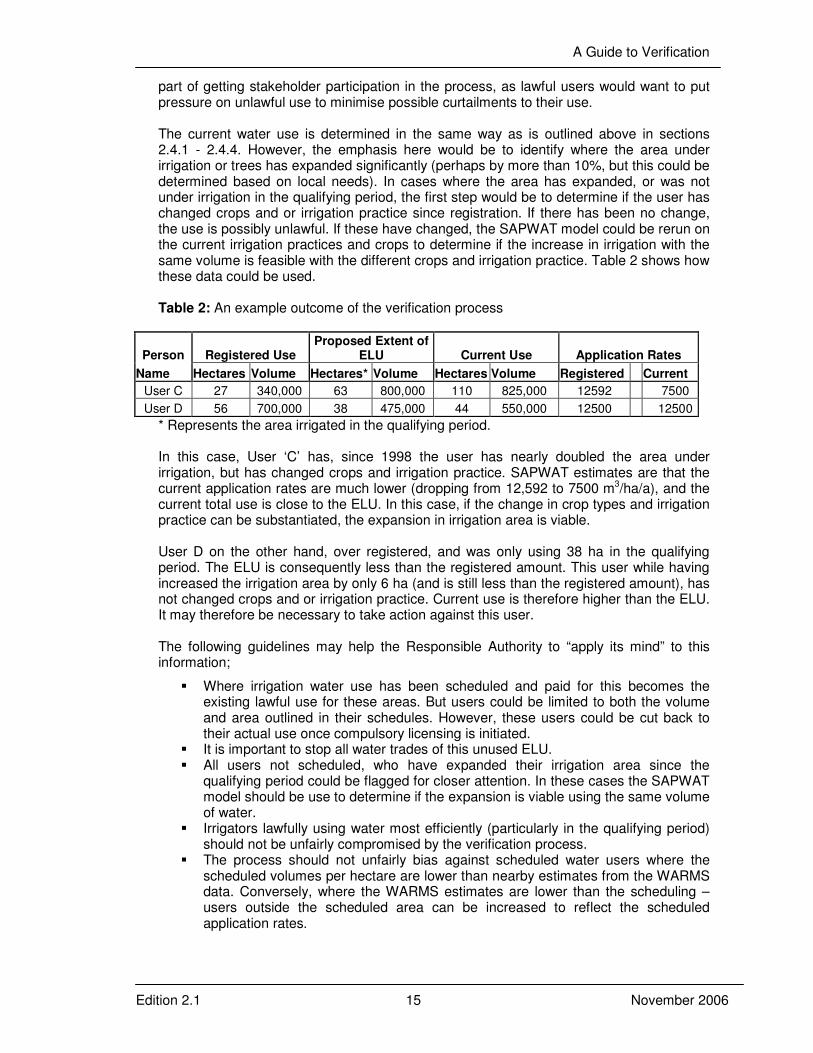
part of getting stakeholder participation in the process, as lawful users would want to put pressure on unlawful use to minimise possible curtailments to their use. The current water use is determined in the same way as is outlined above in sections 2.4.1 - 2.4.4. However, the emphasis here would be to identify where the area under irrigation or trees has expanded significantly (perhaps by more than 10%, but this could be determined based on local needs). In cases where the area has expanded, or was not under irrigation in the qualifying period, the first step would be to determine if the user has changed crops and or irrigation practice since registration. If there has been no change, the use is possibly unlawful. If these have changed, the SAPWAT model could be rerun on the current irrigation practices and crops to determine if the increase in irrigation with the same volume is feasible with the different crops and irrigation practice. Table 2 shows how these data could be used. Table 2: An example outcome of the verification process
Person Registered Use Proposed Extent of
ELU Current Use Application Rates
Name Hectares Volume Hectares* Volume Hectares Volume Registered Current
User C 27 340,000 63 800,000 110 825,000 12592 7500
User D 56 700,000 38 475,000 44 550,000 12500 12500
* Represents the area irrigated in the qualifying period. In this case, User ‘C’ has, since 1998 the user has nearly doubled the area under irrigation, but has changed crops and irrigation practice. SAPWAT estimates are that the current application rates are much lower (dropping from 12,592 to 7500 m3/ha/a), and the current total use is close to the ELU. In this case, if the change in crop types and irrigation practice can be substantiated, the expansion in irrigation area is viable. User D on the other hand, over registered, and was only using 38 ha in the qualifying period. The ELU is consequently less than the registered amount. This user while having increased the irrigation area by only 6 ha (and is still less than the registered amount), has not changed crops and or irrigation practice. Current use is therefore higher than the ELU. It may therefore be necessary to take action against this user.
The following guidelines may help the Responsible Authority to “apply its mind” to this information;
� Where irrigation water use has been scheduled and paid for this becomes the
existing lawful use for these areas. But users could be limited to both the volume and area outlined in their schedules. However, these users could be cut back to their actual use once compulsory licensing is initiated.
� It is important to stop all water trades of this unused ELU. � All users not scheduled, who have expanded their irrigation area since the
qualifying period could be flagged for closer attention. In these cases the SAPWAT model should be use to determine if the expansion is viable using the same volume of water.
� Irrigators lawfully using water most efficiently (particularly in the qualifying period) should not be unfairly compromised by the verification process.
� The process should not unfairly bias against scheduled water users where the scheduled volumes per hectare are lower than nearby estimates from the WARMS data. Conversely, where the WARMS estimates are lower than the scheduling –users outside the scheduled area can be increased to reflect the scheduled application rates.
A Guide to Verification
Edition 2.1 16 November 2006
Clearly, these guidelines would be specific to the catchment, or sub-catchment, and must be developed together with people who know the area well. The outcome of process as outlined in Table 2 can be used as a basis for discussion with stakeholders.
2.4.7 Verification in support of water availability assessments The directorate: National Water Resource Planning is in the process of developing detailed water availability assessment tools for all water management areas in South Africa. These assessments will provide a tool to support ongoing water allocations and water use licensing in the catchments, and require detailed information on water use over a period of time. This information can be used to verify the extent of existing lawful water use, but this process requires slightly different approaches. These approaches are described here. The key element of verification as part of water availability assessments is that a longer time period of water actual use is required to calibrate the models. It is recommended that water use is determined for 4 distinct time horizons. However, here too in the absence of actual measured water use data, actual water use has to be determined by proxy. This can be done using any number of agricultural water use models, some of which can also estimate return flows to the system. In the Mokolo catchment, comparison of measured water use data for one user with that produced by the SAPWAT model, shows that the model accurately simulated actual use for that user. If other irrigators were similarly precise with their irrigation scheduling the model may also provide an accurate assessment of water use for the whole of the catchment. Several key elements have arisen from comparing the shorter WARMS based approach outlined in the previous sections, with a more detailed model based approach.
• The shorter WARMS based approach does not necessarily provide accurate assessments of actual use in the qualifying period.
• The WARMS based approach relies more on stakeholder participation, in particular getting clarity around the assumptions.
• Fewer assumptions are necessary in the detailed modelling approach, but require more data to be collated at greater cost in both time and resources.
• Longer-term average water use determined in this way cannot be used to determine ELU, as ELU must be based on qualifying period use.
• Data obtained from the WARMS based approach has limited value in the models. Appendix D, outlines in more detail the approaches required where verification is used to support water availability assessments.
3 WORKING WITH STAKEHOLDERS TO UNDERTAKE VERIFICATION (S35) The determination the extent of existing lawful water use is not a purely legal technical process, particularly as the actual volume irrigated in the qualifying period has to be inferred from the area under irrigation. In this sense, while the SAPWAT model provides an indication of the irrigation requirement, it does leave some margin for adjustments especially when applied by inexperienced users. In addition, SAPWAT may not have been applied in a consistent manner during the registration process. It is therefore recommended that the WARMS data are used as a basis for determining the extent of use in the qualifying period. Expert knowledge of the area can then be used to help make an informed, fair, reasonable and justifiable determination of the proposed

A Guide to Verification
Edition 2.1 17 November 2006
extent of existing lawful water use based on these data. These determinations can then be discussed with stakeholders, and if necessary adjustments can made to the way irrigation volumes were determined, that all stakeholders feel is fair11. This process will also -promote a measure of self-policing among users, and would limit the possibilities for the process to be held to ransom by individual users. The following steps are suggested for where the process is limited to verification, and where time and costs are important;
1. Cadastral data, and areas under irrigation (from Landsat and any readily available remote sensing platform providing more accurate data) must be determined, and compared to the latest data from WARMS for each property. Field boundaries should as far as possible be determined from orthophotos or actual surveyed data.
2. Current, qualifying period and registered water use as both areas and volumes should be collated, and fair and justifiable determinations of proposed existing lawful use made based on the WARMS data, and best available areas under irrigation. This should be done internally by the responsible authority. Water use includes determining the volume of storage on each property.
3. The data on the registration forms must be used as a basis for determining the volume of water irrigated per hectare, and the remotely sensed data is used to confirm the area under irrigation in the qualifying period. The volume of storage must be determined using the formulae included in Appendix D.
4. Where previous legislation may have limited the volume irrigated or stored, these determinations must be used.
5. All existing water users should be given notice of the intention to determine the proposed extent of existing lawful use in the catchment.
6. This notice should also invite users to a meeting / workshop to discuss the process, and the data made available to all interested parties and/or published by irrigation boards and WUAs.
7. The workshop should start by explaining the verification process, and how existing lawful use was determined, highlighting the assumptions made in determining proposed existing lawful water use. These assumptions could be;
• Satellite determinations of areas under irrigation are accurate.
• The registration on WARMS for that property is correct.
• The use has been linked to the correct cadastral property.
• Water use on sub-divisions of the property since the qualifying period are proportional to the original total use for the property.
• Site specific assumptions for particular users. 8. Users should be given a reasonable time to respond to or challenge these
assumptions. This must be done in writing, providing additional information addressing the assumptions made – and indicating why these are not applicable to their use.
9. After considering these objections, the Responsible Authority can finalise the tables.
10. All existing users should then be invited to apply for verification (Section 35[1 & 2]) based on the updated tables. This notification must be sent as registered mail to each user – including the updated estimation of proposed ELU for their specific use. Suitable application forms must accompany this notification. Users can also be told that the full tables are available for inspection.
11. Comments should be invited from all interested parties (Section 35[3c]).
11
Legal opinion has indicated that it is possible for the responsible authority to agree on particular approaches with stakeholders.

A Guide to Verification
Edition 2.1 18 November 2006
12. Existing users may further dispute the figures outlined (Section 35[3d]), and in this case could be requested to provide additional information at their cost to back up their claims (Section35[3a]).
13. The users should be given a reasonable time to respond, and once all the applications and responses have been evaluated, a certificate outlining the extent of existing lawful use on each property can be issued. (Section 35[4])
14. This determination will limit the extent of existing lawful use identified under Section 32(1), and as such agreements must be made on how the user will curtail his/her use to these levels (Section 35[5]).
15. Where users are currently using water unlawfully, the Responsible Authority must issue a directive to the user to stop the water use (Section 53), and may consider further actions under Sections 151-153 of the NWA.
The following procedure is recommended if the verification process is to be used as a basis for water resource availability assessments; (This process is more resource intensive, and time consuming).
1. Cadastral data, and areas under irrigation must be determined from Landsat data supported by accurate field boundaries. This should be done for 4 time horizons.
2. The SAPWAT model should be calibrated for each cadastral property for the full period of data available, and monthly water use and return flow data calculated. The same rainfall sequences should be used to calculate runoff in the WRSM2000 model.
3. Agricultural water use experts familiar with the area should be used support the calibration of the SAPWAT model.
4. If actual measured water use data are available for some users, these should be used to validate the determinations for other water users. These data should be provided in a format required by the water availability models.
5. Storage volumes and areas must be determined and provided in the format required by the water availability models.
6. Where previous legislation may have limited the volume irrigated or stored, these determinations must be included in the database.
7. All existing water users should be given notice of the intention to determine the proposed extent of existing lawful use in the catchment.
8. This notice should also invite users to a meeting / workshop to discuss the process, and the data made available to all interested parties and/or published by irrigation boards and WUAs.
9. The workshop should start by explaining the verification process, and how existing lawful use was determined, highlighting the assumptions made in determining proposed existing lawful water use. These assumptions could be;
• Assumptions used to calibrate the SAPWAT model are applicable to each property – including those where users have farmed less “scientifically”.
• The use has been linked to the correct cadastral property.
• Water use on sub-divisions of the property since the qualifying period are proportional to the original total use for the property.
• Site specific assumptions for particular users. 10. Users should be given a reasonable time to respond to or challenge these
assumptions. This must be done in writing, providing additional information addressing the assumptions made – and indicating why these are not applicable to their use.
11. After considering these objections, the Responsible Authority can finalise the tables.
12. All existing users should then be invited to apply for verification (Section 35[1 & 2]) based on the updated tables. This notification must be sent as registered mail to each user – including the updated estimation of proposed ELU for their specific

A Guide to Verification
Edition 2.1 19 November 2006
use. Suitable application forms must accompany this notification. Users can also be told that the full tables are available for inspection.
13. Comments should be invited from all interested parties (Section 35[3c]). 14. Existing users may further dispute the figures outlined (Section 35[3d]), and in
this case could be requested to provide additional information at their cost to back up their claims (Section35[3a]).
15. The users should be given a reasonable time to respond, and once all the applications and responses have been evaluated, a certificate outlining the extent of existing lawful use on each property can be issued. (Section 35[4]).
16. This determination will limit the extent of existing lawful use identified under Section 32(1), and as such agreements must be made on how the user will curtail his/her use to these levels (Section 35[5]).
17. Where users are currently using water unlawfully, the Responsible Authority must issue a directive to the user to stop the water use (Section 53), and may consider further actions under Sections 151-153 of the NWA.

A Guide to Verification
Edition 2.1 20 November 2006
APPENDIX A – The qualifying period
The “qualifying period” refers to the 2 years before the implementation of the National Water Act. In effect water use, which was lawful in these 2 years, can be considered as an ELU. The implementation date of the NWA was given by Proclamation R95, 1998, as being 1 October 1998. However, only certain sections and Schedules of the NWA came into effect on 1 October 1998. This excluded inter alia the following provisions of the previous Water Act; Sections 9B, 10, 32B, 56(3), 62, 63, 66, 88, 89(1) (j)12. These sections remained in force until 1 October 1998. Sections 32B, 56(3), 62, 63 and 66 of Water Act, No. 54 of 1956 deal with the water use in proclaimed government water control areas. Sections 9, 9B and 10 of the Water Act No. 54 of 1956 deal with mainly irrigation water use outside proclaimed government water control areas. This means that any water use and any authorisations that could be lawfully exercised under the Water Act No. 54 of 1956, could continue (e.g. building of dams under section 9B up to 250 000 m3, taking of 21, 4 ha @ 6 100 m3 in the Vaal Dam Catchment Government Water Control Area) until the remaining sections of the NWA came into effect. Section 32 (1) of the NWA states that an existing lawful water use means a water use which has taken place at any time during a period of two years immediately before the date of commencement of the Act; and which was authorised by or under any law which was in force immediately before the date of commencement of the Act. This means that; Groundwater use outside of any proclaimed Underground Government Water Controlled Areas was considered to be private water under the 1956 Act, the relevant qualifying period for recognition of existing lawful use from groundwater is therefore the 2-year period before 1 October 1998. The same applies to surface water use that was considered to be “Private water” under the Water Act, No. 54 of 1956. All other irrigation water use falls under Schedule 7 of Proclamation R95, 1998, and the qualifying period means the 2 years before 1 October 1999.
12
Only those sections pertinent to the verification process are mentioned here.
A Guide to Verification
Edition 2.1 21 November 2006
APPENDIX B Calculating the “fair share principle” for areas outside of government water control areas.
B1 - Background
The old Water Act of 1956 allowed users outside of government water control areas (i.e. public water) to use water flowing alongside, over or under their property, without the need for formal authorisation. However, this “riparian principle” did not allow for unlimited water use, and a “fair share principle” had to be applied. This in effect limited the user to a fair share of the water so as not to prejudice downstream users.
In these cases a distinction was made between normal flow and surplus water. A riparian owner was therefore entitled to the reasonable use of his share of the “normal flow” for agricultural and urban purposes on riparian land. (Domestic use and stock watering was included in the definition of agricultural use.) The power to apportion the normal flow was vested in the water court, according to certain “rules”. In practice, however, each riparian owner could take as much water as they considered as being his or her share, and the water court only became involved if the court was approached to determine everyone’s fair share. Usually this was done if there was a dispute over the water. Any court order apportioning water will therefore also limit the use in the qualifying period. As such, in cases where the use in the qualifying period exceeds the water available, the following must be taken into account when making a proposed determination of the extent of existing lawful water use. The Critical (bottle-neck) period The fair share principle is relevant only to that time of the year when irrigation demand is high and water relatively scarce, the so-called bottle-neck period. The old Water Act therefore required a certain minimum flow (the “normal flow”) in this bottle-neck period in order to ensure that downstream users received a fair share of the water. This obviously differs between areas, but is usually that time of the year when planting has begun, but before the rains have started. The normal flow therefore is not necessarily the lowest average flow in a year. It is the lowest reliable flow in the critical period. Assurance of supply or sustainability Irrigation with the normal flow must be of an acceptable reliability, otherwise the capital and operational expense makes irrigation uneconomic. The reliability required depends on the demands of the crops utilised. Fruit trees require an almost 100% assurance of supply, whilst other crops can suffer lack of water to varying degrees. The higher the assurance required, the lower the normal flow will be. Generally a 70% assurance is acceptable to most crops and for that reason this is often used as the measure. Other percentages can be preferable in some areas. Limits to cutting back based on the normal flow principle Although water use in the qualifying period could be reduced where it is felt that the normal flow is not being fairly shared, the division of the normal flow should still be reasonable. This means that use must normally be economically viable. What is economically viable will depend on the circumstances of each case, but certain norms have been developed and have regularly been accepted by the water courts. The norms most often used are a limit of 2 km distance from the river and 60 m above the riverbed beyond which irrigation is deemed to be uneconomic. Pietersburg principle This principle states that in apportioning the normal flow, a water court may not take into account a greater area of irrigable land on any riparian property than can be irrigated with the normal flow. The principle was first applied in the water court case of Ex Parte Transvaal Trust

A Guide to Verification
Edition 2.1 22 November 2006
& Finance Co Ltd (1931). The Water Act 54 of 1956 incorporated the principle and made it obligatory. To illustrate the Pieterburg principle, suppose that the normal flow is to be apportioned between 2 properties, property A with 5 ha irrigable land and property B with 95 ha (therefore 100 ha in total), while the normal flow is only sufficient to irrigate 20 ha. Under a proportional apportionment the 2 properties would be entitled to-
1 Property A to (5/100)x20, therefore 1 ha; and
2 Property B to (95/100)x20, therefore 19 ha.
This would have the effect that A would receive so little water that irrigation becomes uneconomic. The Pieterburg principle now limits the irrigable land of property B to be taken into account to 20 ha, because the normal flow is only sufficient for 20 ha. Property A’s total area of 5 ha is taken into account because it is less than 20 ha. This gives a total of 25 ha. Now the two properties are entitled to-
3 Property A to (5/25)x20, therefore 4 ha; and
4 Property B to (20/25)x20, therefore 16 ha.
The principle obviously favours smaller properties with less irrigable land. Surplus water
Surplus water is the water outside of the “bottle-neck” period. Every riparian owner had a right to the use as much of the surplus water of a public stream as he can beneficially use. A riparian owner also had the right to impound and store surplus water. The Water Court therefore had no power to apportion surplus flow. However in 1971 (as amended in 1975) section 9B was added to the old Water Act. This limited the storage of surplus water to 250 000 m³ and an abstraction to 110 l/s per farm as (existed on 28 May 1975) without a permit of the Minister. In 1987 a further refinement was introduced by the addition of section 9B(1C) which allows the Minister to vary the figures of 250 000 m³ (storage) and 110 l/s (abstraction) for particular areas. The position is therefore that every riparian owner is after 28 May 1975 was entitled to construct a storage dam of up to 250 000 m³ capacity to impound and store surplus water or to abstract a maximum of 110 l/s (or such other quantities which the Minister may have determined for an area) with a permit of the Minister. For any larger dam or pump a permit from the Minister was required.
B2 – Applying a “fair share principle” to determining the extent of existing lawful water use. It is immediately obvious that where Court Orders have not apportioned the water, and where the total use in the qualifying period exceeds the water available at a reasonable assurance of supply, that some kind of fair share principle must be taken into account when determining the proposed extent of existing lawful water use. However, achieving this on a catchment wide basis may prove difficult. The following approach to these cases has however been distilled from the above principles All the water used during the qualifying period in government water control areas, as well as any dormant and paid for scheduled water13 must be taken to be ELU. Any water use on properties, where there is storage and where that storage is lawful must be taken to be an ELU. Thereafter the remaining water, as determined from the latest Internal Strategic Perspective or Catchment Management Strategy must be apportioned as ELU to the remaining properties proportional to the area irrigated during the qualifying period. If this process results in an ELU on any property which is uneconomic approaches similar to that outlined in the Pietersburg principle can be applied.
13
This must include the payment of any applicable scheme charges.

A Guide to Verification
Edition 2.1 23 November 2006
APPENDIX C: Reasons for individual registrations and licensing
The following reasoning was provided by Mr Johnny Beumer quoting a DWAF policy statement
Individuals under a WMI such as a WUA need to be registered in WARMS. The reasons for this are as follows: - National Register of Water Use must be maintained by the Minister and must contain
all water use information. - In the past WUAs needed to submit annual Lists of Rateable Areas to DWAF under
the previous water act. This requirement has fallen away and individual water use information on WARMS will in future be the only source of such information that will be maintained.
- DWAF/CMAs must be able to issue WARMS registration certificates i.r.o. all water users.
- DWAF/CMAs must be able to issue “outstanding debt” certificates i.r.o. each property whenever the property changes from owner.
- If a WUA does not perform, the administration of such WUA must be taken over by the Minister (DWAF) which can be easily done if all individual water use data is on WARMS.
- The WUA can be assigned to act as a billing agent for DWAF/CMA in which case the individual water users will be linked with the “bulk bill to party” facility on SAP. The WUA will then receive consolidated billing documents with all property and water use detail.
- An agreement between the DWAF and a WUA must first be concluded before the WUA will be able to act as bulk billing agent. Without such an agreement or after termination of such an agreement DWAF/CMA must be able to bill the individuals under that WUA which water use details is obtained from WARMS.

A Guide to Verification
Edition 2.1 24 November 2006
APPENDIX D: Recommended methods for determining the volumes of storage
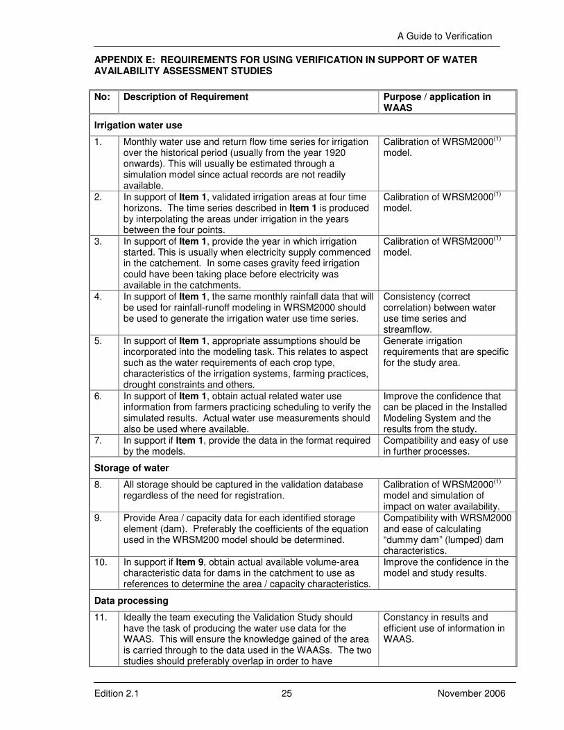
A Guide to Verification
Edition 2.1 25 November 2006
APPENDIX E: REQUIREMENTS FOR USING VERIFICATION IN SUPPORT OF WATER AVAILABILITY ASSESSMENT STUDIES
No: Description of Requirement Purpose / application in WAAS
Irrigation water use
1. Monthly water use and return flow time series for irrigation over the historical period (usually from the year 1920 onwards). This will usually be estimated through a simulation model since actual records are not readily available.
Calibration of WRSM2000(1) model.
2. In support of Item 1, validated irrigation areas at four time horizons. The time series described in Item 1 is produced by interpolating the areas under irrigation in the years between the four points.
Calibration of WRSM2000(1) model.
3. In support of Item 1, provide the year in which irrigation started. This is usually when electricity supply commenced in the catchement. In some cases gravity feed irrigation could have been taking place before electricity was available in the catchments.
Calibration of WRSM2000(1) model.
4. In support of Item 1, the same monthly rainfall data that will be used for rainfall-runoff modeling in WRSM2000 should be used to generate the irrigation water use time series.
Consistency (correct correlation) between water use time series and streamflow.
5. In support of Item 1, appropriate assumptions should be incorporated into the modeling task. This relates to aspect such as the water requirements of each crop type, characteristics of the irrigation systems, farming practices, drought constraints and others.
Generate irrigation requirements that are specific for the study area.
6. In support of Item 1, obtain actual related water use information from farmers practicing scheduling to verify the simulated results. Actual water use measurements should also be used where available.
Improve the confidence that can be placed in the Installed Modeling System and the results from the study.
7. In support if Item 1, provide the data in the format required by the models.
Compatibility and easy of use in further processes.
Storage of water
8. All storage should be captured in the validation database regardless of the need for registration.
Calibration of WRSM2000(1) model and simulation of impact on water availability.
9. Provide Area / capacity data for each identified storage element (dam). Preferably the coefficients of the equation used in the WRSM200 model should be determined.
Compatibility with WRSM2000 and ease of calculating “dummy dam” (lumped) dam characteristics.
10. In support if Item 9, obtain actual available volume-area characteristic data for dams in the catchment to use as references to determine the area / capacity characteristics.
Improve the confidence in the model and study results.
Data processing
11. Ideally the team executing the Validation Study should have the task of producing the water use data for the WAAS. This will ensure the knowledge gained of the area is carried through to the data used in the WAASs. The two studies should preferably overlap in order to have
Constancy in results and efficient use of information in WAAS.
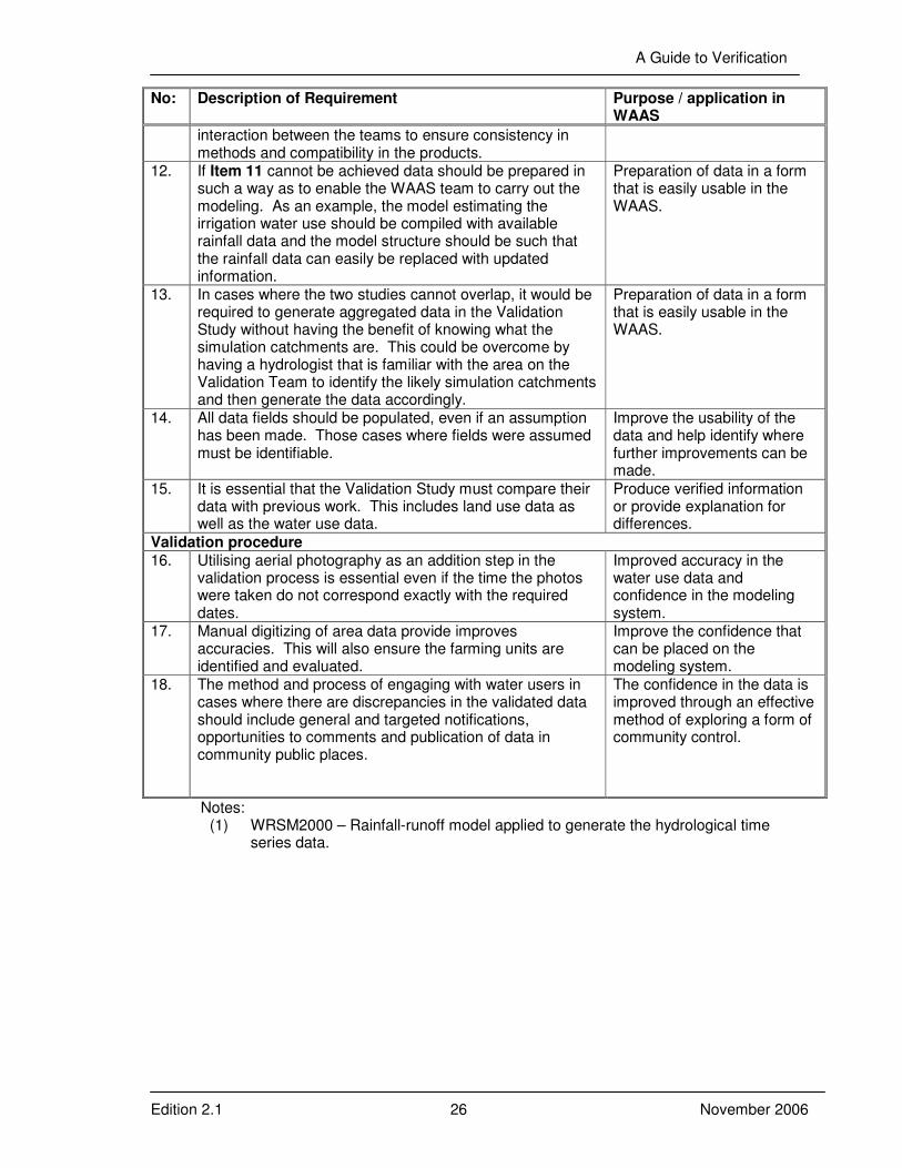
A Guide to Verification
Edition 2.1 26 November 2006
No: Description of Requirement Purpose / application in WAAS
interaction between the teams to ensure consistency in methods and compatibility in the products.
12. If Item 11 cannot be achieved data should be prepared in such a way as to enable the WAAS team to carry out the modeling. As an example, the model estimating the irrigation water use should be compiled with available rainfall data and the model structure should be such that the rainfall data can easily be replaced with updated information.
Preparation of data in a form that is easily usable in the WAAS.
13. In cases where the two studies cannot overlap, it would be required to generate aggregated data in the Validation Study without having the benefit of knowing what the simulation catchments are. This could be overcome by having a hydrologist that is familiar with the area on the Validation Team to identify the likely simulation catchments and then generate the data accordingly.
Preparation of data in a form that is easily usable in the WAAS.
14. All data fields should be populated, even if an assumption has been made. Those cases where fields were assumed must be identifiable.
Improve the usability of the data and help identify where further improvements can be made.
15. It is essential that the Validation Study must compare their data with previous work. This includes land use data as well as the water use data.
Produce verified information or provide explanation for differences.
Validation procedure 16. Utilising aerial photography as an addition step in the
validation process is essential even if the time the photos were taken do not correspond exactly with the required dates.
Improved accuracy in the water use data and confidence in the modeling system.
17. Manual digitizing of area data provide improves accuracies. This will also ensure the farming units are identified and evaluated.
Improve the confidence that can be placed on the modeling system.
18. The method and process of engaging with water users in cases where there are discrepancies in the validated data should include general and targeted notifications, opportunities to comments and publication of data in community public places.
The confidence in the data is improved through an effective method of exploring a form of community control.
Notes: (1) WRSM2000 – Rainfall-runoff model applied to generate the hydrological time
series data.