Embed Size (px)
Citation preview
REPLY TO ATTENTION OF
DEPARTMENT OF THE ARMY ST. PAUL DISTRICT, CORPS OF ENGINEERS
180 FIFTH STREET EAST, SUITE 700
ST. PAUL, MN 55101-1678
June 27, 2014
Regional Planning and Environment Division North
Christine Lutheran Church 110 4111 St Christine, ND 58015
Dear Christine Lutheran Church, Christine Cemetery:
It has come to our attention you may be concerned with potential impacts to cemeteries upstream of the staging area of the proposed Fargo-Moorhead Metropolitan Flood Risk Management Project (Project). We hope the enclosed infmmation is useful to you. As explained further below, your cemetery will experience no water depth from the Project.
In September of2013, after the Supplemental Environmental Assessment for the Project was finalized, the St. Paul District, U.S. Army Corps of Engineers (Corps) and the Fargo-Moorhead Diversion Authority (Sponsor) gathered information from various map and air photo sources, through interviews with cemetery representatives, and during on-site visits to cemeteries on both sides ofthe Red River from Georgetown, Minnesota, in the north to Abercrombie, Nmih Dakota and McCauleyville, Minnesota, in the south. The purpose of this effmi was to get a better understanding of potential Project impacts and benefits to cemeteries in the region, to identify potential mitigation measures that could be used to offset Project impacts, and to form a general understanding of existing flooding issues associated with regional cemeteries.
Based on that information, a Cemetery Study Report was prepared which lists (1) cunent and potential impacts to the cemeteries from flooding, (2) current and anticipated clean-up effmis after flooding, and (3) mitigation options to remedy or prevent potential Project-related impacts. The repmi also includes maps showing the approximate size and location of each of the 54 cemeteries identified as pmi of the study and gives water elevations and duration of water above natural ground level both with and without the Project in place for the 1 0-year, 50-year, 100-year, and 500-year flood events. The complete Cemetery Study Report is posted on the Sponsor's website at www.fmdiversion.com.
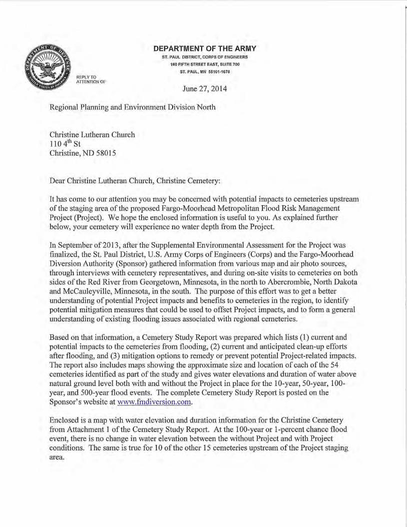
Enclosed is a map with water elevation and duration infmmation for the Christine Cemetery from Attachment 1 of the Cemetery Study Repmi. At the 100-year or 1-percent chance flood event, there is no change in water elevation between the without Project and with Project conditions. The same is true for 10 ofthe other 15 cemeteries upstream ofthe Project staging area.

The next step is to develop mitigation plans in consultation with the seven cemeteries in the staging area and the four cemeteries upstream of the staging area which may be impacted by the Project. The Corps' goal is to develop an actual site-specific Mitigation Plan within a year. It is impmiant to note that actual implementation of any mitigation will be completed prior to the completion of the Project.
Once again, the Christine Cemetery will experience no direct impacts from the Project and therefore will not be included in a mitigation plan. We hope this infmmation is useful to you. The point-of-contact for this action is Mr. Jon Sobiech, PD-Environmental, U.S. Atmy Coips of Engineers, St. Paul District, 180 Fifth Street East, Suite 700, St. Paul, MN 55101-1678, phone (651) 290-5428 or by email at [email protected].
Enclosure Site-specific cemetery map
Sincerely,
Tel1'y J. Birkenstock Deputy Chief, Regional Planning and
Environment Division North
Cemet~~y Map ... CHRISTINE CEMETERY
Legend
(c:::Jl cemeteries
CJ 450' Buffer Around River POII>:T,
Return Frequency Peak Water '"''·"auvu \'-'<.I:J~J "' Peak Water Elevation
WSEL Above Natural Elevation 1
Ground Ground 10-Year 919.9 0 919.9 0 50-Year 921.5 0 923.3 0
100-Year 923.1 0 924.0 SOD-Year 930,3 5 930,3
Notn: 927.0 !s thcnpprmdmntc lowost sltoclcwdon All Hydrnunc Dnlll Tnlwn rrom Alns<J 1 HEC-RAS Mx:luls
firu._ 1000000131100
llll l-IMG I W.E s
Countv: Richland Coul'lty, ND
.. ~ .. ~ ...... .c======~ ....... " F~t 0 50 100 200 300 400
REPLY TO ATIENTION OF
DEPARTMENT OF THE ARMY ST. PAUL DISTRICT, CORPS OF ENGINEERS
180 FIFTH STREET EAST, SUITE 700
ST. PAUL, MN 55101-1678
June 27, 2014
Regional Planning and Environment Division North
Dear Mr. , Pioneer Cemetery:
It has come to our attention you may be concerned with potential impacts to cemeteries upstream of the staging area of the proposed Fargo-Moorhead Metropolitan Flood Risk Management Project (Project). We hope the enclosed infmmation is useful to you. As explained fu1iher below, your cemetery will experience no water depth from the Project.
In September of2013, after the Supplemental Environmental Assessment for the Project was finalized, the St. Paul District, U.S. Army Corps of Engineers (Corps) and the Fargo-Moorhead Diversion Authority (Sponsor) gathered information from various map and air photo sources, through interviews with cemetery representatives, and during on-site visits to cemeteries on both sides of the Red River from Georgetown, Minnesota, in the nmih to Abercrombie, Nmih Dakota and McCauleyville, Minnesota, in the south. The purpose of this effort was to get a better understanding of potential Project impacts and benefits to cemeteries in the region, to identify potential mitigation measures that could be used to offset Project impacts, and to form a general understanding of existing flooding issues associated with regional cemeteries.
Based on that information, a Cemetery Study Repmi was prepared which lists (1) cunent and potential impacts to the cemeteries from flooding, (2) current and anticipated clean-up efforts after flooding, and (3) mitigation options to remedy or prevent potential Project-related impacts. The repmi also includes maps showing the approximate size and location of each of the 54 cemeteries identified as pali of the study and gives water elevations and duration of water above natural ground level both with and without the Project in place for the 10-year, 50-year, 100-year, and 500-year flood events. The complete Cemetery Study Repmi is posted on the Sponsor's website at www.fmdiversion.com.
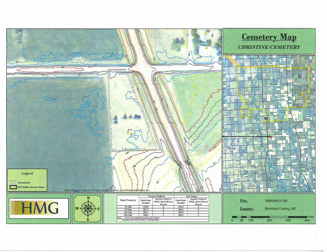
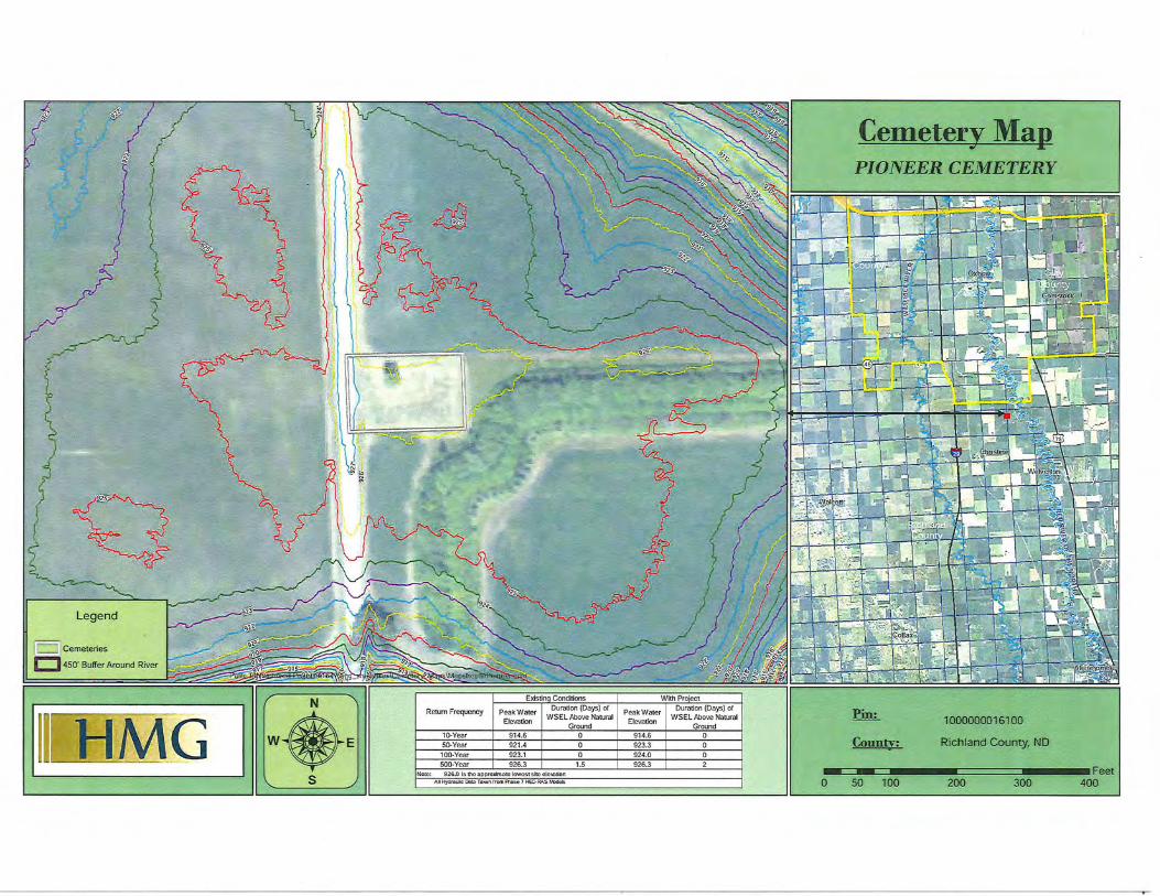
Enclosed is a map with water elevation and duration infmmation for the Pioneer Cemetery from Attachment 1 of the Cemetery Study Repmi. At the 100-year or 1-percent chance flood event, there is no change in water elevation between the without Project and with Project conditions. The same is true for 10 of the other 15 cemeteries upstream of the Project staging area.

The next step is to develop mitigation plans in consultation with the seven cemeteries in the staging area and the four cemeteries upstream of the staging area which may be impacted by the Project. The Corps' goal is to develop an actual site-specific Mitigation Plan within a year. It is important to note that actual implementation of any mitigation will be completed prior to the completion of the Project.
Once again, the Pioneer Cemetery will experience no direct impacts from the Project and therefore will not be included in a mitigation plan. We hope this information is useful to you. The point-of-contact for this action is Mr. Jon Sobiech, PD-Environmental, U.S. Army Corps of Engineers, St. Paul District, 180 Fifth Street East, Suite 700, St. Paul, MN 55101-1678, phone ( 651) 290-5428 or by email at J onathan.J [email protected].
Enclosure Site-specific cemetery map
Sincerely,
Terry J. Birkenstock Deputy Chief, Regional Planning and
Environment Division North
[ p J cemeteries
t::J450' Buffer Around River
1111 H·MG I w •• s
Return Frequency Peak Water L..IUICIUUII \L..ICIJ!>J Ul
Elevation WSEL Above Natural
Ground 10-Year 914.6 0 50-Year 921.4 0
100-Year 923.1 0 500-Year 926.3 1.5
Noto. 926,0 [5 the npproxlmnro lowcst 5 ltc o lc110tlon
AH Hydraulic l:kllll Tnkun lrom Phosa 7 HEC-RAS Modats
Peak Water I Duration (Days) of
Elevation WSEL~:~:dNatural
914.6 0 923.3 0 924.0
926.3
Cemetery Map - ...
PIONEER CEMETERY
~
County:
1000000016100
Richland County, ND
0 •~~ .. c= ........ ~~c=c==;~ ...... :Feet - - 400 50 100 200 300

REPLY TO ATIENTION OF
DEPARTMENT OF THE ARMY ST. PAUL DISTRICT, CORPS OF ENGINEERS
180 FIFTH STREET EAST, SUITE 700
ST. PAUL, MN 55101-1678
June 27, 2014
Regional Planning and Environment Division North
Dear Mr. , Richland Cemetery:
It has come to our attention you may be concerned with potential impacts to cemeteries upstream of the staging area of the proposed Fargo-Moorhead Metropolitan Flood Risk Management Project (Project). We hope the enclosed information is useful to you. As explained futiher below, your cemetery will experience no water depth from the Project.
In September of 2013, after the Supplemental Environmental Assessment for the Project was finalized, the St. Paul District, U.S. Army Corps of Engineers (Corps) and the Fargo-Moorhead Diversion Authority (Sponsor) gathered information from various map and air photo sources, through interviews with cemetery representatives, and during on-site visits to cemeteries on both sides of the Red River from Georgetown, Minnesota, in the nmih to Abercrombie, North Dakota and McCauleyville, Minnesota, in the south. The purpose of this effort was to get a better understanding of potential Project impacts and benefits to cemeteries in the region, to identify potential mitigation measures that could be used to offset Project impacts, and to form a general understanding of existing flooding issues associated with regional cemeteries.
Based on that information, a Cemetery Study Repmi was prepared which lists (1) cmTent and potential impacts to the cemeteries from flooding, (2) current and anticipated clean-up effmis after flooding, and (3) mitigation options to remedy or prevent potential Project-related impacts. The repmi also includes maps showing the approximate size and location of each of the 54 cemeteries identified as pali of the study and gives water elevations and duration of water above natural ground level both with and without the Project in place for the 1 0-year, 50-year, 100-year, and 500-year flood events. The complete Cemetery Study Report is posted on the Sponsor's website at www.fmdiversion.com.
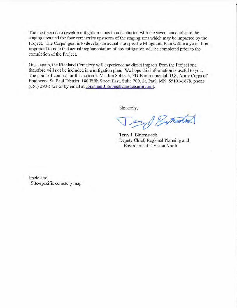
Enclosed is a map with water elevation and duration information for the Richland Cemetery from Attachment 1 of the Cemetery Study Report. At the 100-year or 1-percent chance flood event, there is no change in water elevation between the without Project and with Project conditions. The same is true for 10 ofthe other 15 cemeteries upstream ofthe Project staging area.
The next step is to develop mitigation plans in consultation with the seven cemeteries in the staging area and the four cemeteries upstream of the staging area which may be impacted by the Project. The Corps' goal is to develop an actual site-specific Mitigation Plan within a year. It is important to note that actual implementation of any mitigation will be completed prior to the completion of the Project.
Once again, the Richland Cemetery will experience no direct impacts from the Project and therefore will not be included in a mitigation plan. We hope this information is useful to you. The point-of-contact for this action is Mr. Jon Sobiech, PD-Environmental, U.S. Army Corps of Engineers, St. Paul District, 180 Fifth Street East, Suite 700, St. Paul, MN 55101-1678, phone (651) 290-5428 or by email at [email protected].
Enclosure Site-specific cemetery map
Sincerely,
Teny J. Birkenstock Deputy Chief, Regional Planning and
Environment Division Nmih
1111 H]MG I W.E s
Rerum Frequency
10-Year
50-Year 100-Year 500-Year I 934.8
Note: 936.0 Is the opprox!motc Jowcstsltc clo\Cltlon AD Hydraulic Cllto Toll&n from A'lostt 7 HECRAS M:ldols
Cemetery Map - ;II.
RICHLAND CEMETERY
f.m;_
County:
1000000267100
Richland County, NO
- - Feet 0 50 100 200 300 400

REPLY TO ATTENTION OF
DEPARTMENT OF THE ARMY ST. PAUL DISTRICT, CORPS OF ENGINEERS
180 FIFTH STREET EAST, SUITE 700
ST. PAUL, MN 55101-1678
June 27, 2014
Regional Planning and Environment Division North
Dear Mr. , Richland Church Cemetery:
It has come to our attention you may be concerned with potential impacts to cemeteries upstream of the staging area of the proposed Fargo-Moorhead Metropolitan Flood Risk Management Project (Project). We hope the enclosed infmmation is useful to you. As explained further below, your cemetery will experience no water depth from the Project.
In September of2013, after the Supplemental Environmental Assessment for the Project was finalized, the St. Paul District, U.S. Army Cmps of Engineers (Cmps) and the Fargo-Moorhead Diversion Authority (Sponsor) gathered information from various map and air photo sources, through interviews with cemetery representatives, and during on-site visits to cemeteries on both sides of the Red River from Georgetown, Minnesota, in the nmih to Abercrombie, Nmih Dakota and McCauleyville, Minnesota, in the south. The pmpose of this effort was to get a better understanding of potential Project impacts and benefits to cemeteries in the region, to identify potential mitigation measures that could be used to offset Project impacts, and to form a general understanding of existing flooding issues associated with regional cemeteries.
Based on that information, a Cemetery Study Repmt was prepared which lists (1) cunent and potential impacts to the cemeteries from flooding, (2) current and anticipated clean-up effmis after flooding, and (3) mitigation options to remedy or prevent potential Project-related impacts. The repmt also includes maps showing the approximate size and location of each of the 54 cemeteries identified as pmt of the study and gives water elevations and duration of water above natural ground level both with and without the Project in place for the 10-year, 50-year, 100-year, and 500-year flood events. The complete Cemetery Study Repmt is posted on the Sponsor's website at www.fmdiversion.com.
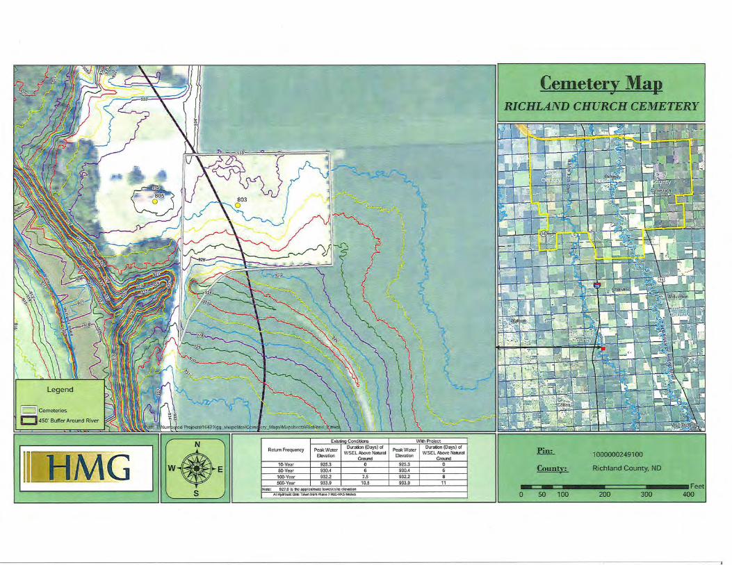
Enclosed is a map with water elevation and duration information for the Richland Church Cemetery from Attachment 1 of the Cemetery Study Repmt. At the 1 00-year or 1-percent chance flood event, there is no change in water elevation between the without Project and with Project conditions. The same is true for 10 ofthe other 15 cemeteries upstream ofthe Project staging area.
The next step is to develop mitigation plans in consultation with the seven cemeteries in the staging area and the four cemeteries upstream of the staging area which may be impacted by the Project. The Corps' goal is to develop an actual site-specific Mitigation Plan within a year. It is impmiant to note that actual implementation of any mitigation will be completed prior to the completion of the Project.
Once again, the Richland Church Cemetery will experience no direct impacts from the Project and therefore will not be included in a mitigation plan. We hope this information is useful to you. The point-of-contact for this action is Mr. Jon Sobiech, PD-Environmental, U.S. Army Corps of Engineers, St. Paul District, 180 Fifth Street East, Suite 700, St. Paul, MN 55101-1678, phone (651) 290-5428 or by email at [email protected].
Enclosure Site-specific cemetery map
Sincerely,
Terry J. Birkenstock Deputy Chief, Regional Planning and
Environment Division Nmih
L w J Cemeteries
E::] 450' Buffer Around River
lllffi:M"G I W.E s
Return Frequency Peak Water LJUICIUUII \'-'"'J"') Ul
Elevation WSEL Above Natural
Ground 10-Vear 925.3 0 50-Year 930.4 6
100-Year 932.2 7.5 500-Year 933.9 10.5
Note: 927.0 ls thc approJCmntc !owcstsltcclcvatJon Al l Hydmuic Dtlto Toktrn I rom A'loso 7 HEC-RAS M:xlal:l
Peak Water Elevation 1
Ground 925.3 1 0 930.4 932.2 933,9 l 11
Cemetery Map ... RICHLAND CHURCH CEMETERY
lin;_
Countv:
0 50 100
10000Q0249100
Ri.chland County, NO
200 300 400

REPLY TO ATTENTION OF
DEPARTMENT OF THE ARMY ST. PAUL DISTRICT, CORPS OF ENGINEERS
180 FIFTH STREET EAST, SUITE 700
ST. PAUL, MN 55101-1678
June 27, 2014
Regional Planning and Environment Division North
Dear Mr. , Abercrombie Cemetery:
It has come to our attention you may be concerned with potential impacts to cemeteries upstream of the staging area of the proposed Fargo-Moorhead Metropolitan Flood Risk Management Project (Project). We hope the enclosed information is useful to you. As explained fmiher below, your cemetery will experience no water depth from the Project.
In September of2013, after the Supplemental Environmental Assessment for the Project was finalized, the St. Paul District, U.S. Army Corps of Engineers (Corps) and the Fargo-Moorhead Diversion Authority (Sponsor) gathered information from various map and air photo sources, through interviews with cemetery representatives, and during on-site visits to cemeteries on both sides of the Red River from Georgetown, Minnesota, in the nmih to Abercrombie, Nmih Dakota and McCauleyville, Minnesota, in the south. The purpose of this effort was to get a better understanding of potential Project impacts and benefits to cemeteries in the region, to identify potential mitigation measures that could be used to offset Project impacts, and to form a general understanding of existing flooding issues associated with regional cemeteries.
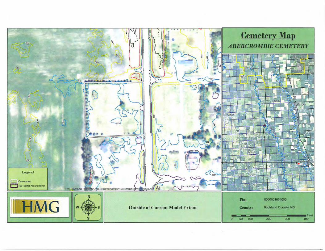
Based on that information, a Cemetery Study Repmi was prepared which lists (1) cunent and potential impacts to the cemeteries from flooding, (2) cunent and anticipated clean-up effmis after flooding, and (3) mitigation options to remedy or prevent potential Project-related impacts. The repmi also includes maps showing the approximate size and location of each of the 54 cemeteries identified as pmi of the study and gives water elevations and duration of water above natural ground level both with and without the Project in place for the 1 0-year, 50-year, 100-year, and 500-year flood events. The complete Cemetery Study Repmi is posted on the Sponsor's website at www.fmdiversion.com.
Enclosed is a map with water elevation and duration infmmation for the Abercrombie Cemetery from Attachment 1 of the Cemetery Study Repmi. At the 100-year or 1-percent chance flood event, there is no change in water elevation between the without Project and with Project conditions. The same is true for 10 ofthe other 15 cemeteries upstream ofthe Project staging area.
The next step is to develop mitigation plans in consultation with the seven cemeteries in the staging area and the four cemeteries upstream of the staging area which may be impacted by the Project. The Corps' goal is to develop an actual site-specific Mitigation Plan within a year. It is impmiant to note that actual implementation of any mitigation will be completed prior to the completion of the Project.
Once again, the Abercrombie Cemetery will experience no direct impacts from the Project and therefore will not be included in a mitigation plan. We hope this information is useful to you. The point-of-contact for this action is Mr. Jon Sobiech, PD-Environmental, U.S. Atmy Corps of Engineers, St. Paul District, 180 Fifth Street East, Suite 700, St. Paul, MN 55101-1678, phone (651) 290-5428 or by email at [email protected].
Enclosure Site-specific cemetery map
Sincerely,
<::j~j~ Teny J. Birkenstock Deputy Chief, Regional Planning and
Environment Division North
~ •~"~· .Ft::
It•·
Legend
I::::JJCemeteries
r::J 450' Buffer Around River
:$
1111 · H'MG I W.E s
2
%.
~'
Cemetery Map - ...
ABERCROMBIE CEMETERY
fin;_ 8000001654050
Outside of Current Model Extent Councy: Richland County, NO
.. c= .. ~ ........ ======~ ........ Fe& 0 so 100 200 300 400
REPLY TO ATTENTION OF
DEPARTMENT OF THE ARMY ST. PAUL DISTRICT, CORPS OF ENGINEERS
180 FIFTH STREET EAST, SUITE 700
ST. PAUL, MN 55101-1678
June 27, 2014
Regional Planning and Environment Division North
Dear Mr. , Emanuel Cemetery:
It has come to our attention you may be concerned with potential impacts to cemeteries upstream of the staging area of the proposed Fargo-Moorhead Metropolitan Flood Risk Management Project (Project). We hope the enclosed infmmation is useful to you. As explained further below, your cemetery will experience no water depth from the Project.
In September of2013, after the Supplemental Environmental Assessment for the Project was finalized, the St. Paul District, U.S. Almy Corps of Engineers (Corps) and the Fargo-Moorhead Diversion Authority (Sponsor) gathered infmmation from various map and air photo sources, through interviews with cemetery representatives, and during on-site visits to cemeteries on both sides of the Red River from Georgetown, Minnesota, in the nmih to Abercrombie, North Dakota and McCauleyville, Minnesota, in the south. The purpose of this effmi was to get a better understanding of potential Project impacts and benefits to cemeteries in the region, to identify potential mitigation measures that could be used to offset Project impacts, and to fmm a general understanding of existing flooding issues associated with regional cemeteries.
Based on that information, a Cemetery Study Repmi was prepared which lists (1) cul1'ent and potential impacts to the cemeteries from flooding, (2) cul1'ent and anticipated clean-up effmis after flooding, and (3) mitigation options to remedy or prevent potential Project-related impacts. The repmi also includes maps showing the approximate size and location of each of the 54 cemeteries identified as pmi of the study and gives water elevations and duration of water above natural ground level both with and without the Project in place for the 10-year, 50-year, 100-year, and 500-year flood events. The complete Cemetery Study Repmi is posted on the Sponsor's website at www.fmdiversion.com.
Enclosed is a map with water elevation and duration information for the Emanuel Cemetery from Attachment 1 of the Cemetery Study Repmi. At the 100-year or 1-percent chance flood event, there is no change in water elevation between the without Project and with Project conditions. The same is true for 10 ofthe other 15 cemeteries upstream ofthe Project staging area.
The next step is to develop mitigation plans in consultation with the seven cemeteries in the staging area and the four cemeteries upstream of the staging area which may be impacted by the Project. The Corps' goal is to develop an actual site-specific Mitigation Plan within a year. It is impmiant to note that actual implementation of any mitigation will be completed prior to the completion of the Project.
Once again, the Emanuel Cemetery will experience no direct impacts from the Project and therefore will not be included in a mitigation plan. We hope this information is useful to you. The point-of-contact for this action is Mr. Jon Sobiech, PD-Environmental, U.S. Almy Corps of Engineers, St. Paul District, 180 Fifth Street East, Suite 700, St. Paul, MN 55101-1678, phone (651) 290-5428 or by email at [email protected].
Enclosure Site-specific cemetery map
Sincerely,
Terry J. Birkenstock Deputy Chief, Regional Planning and
Environment Division Nmih
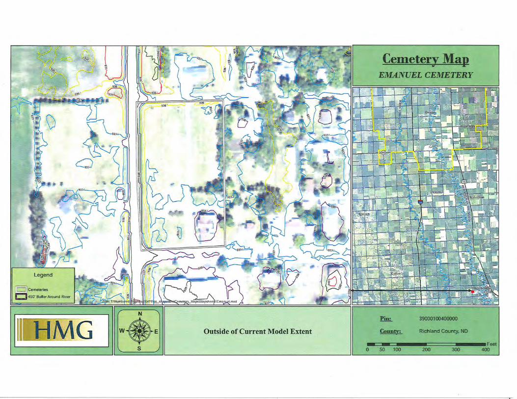
Cemeter_y Map - ... EMANUEL CEMETERY
0 so 100 200 300
Ill! HMli I W.E s
Pin: 39000100400000
Outside of Current Model Extent County: Richland County, ND

REPLY TO ATIENTION OF
DEPARTMENT OF THE ARMY ST. PAUL DISTRICT, CORPS OF ENGINEERS
180 FIFTH STREET EAST, SUITE 700
ST. PAUL, MN 55101-1678
June 27, 2014
Regional Planning and Environment Division Nmih
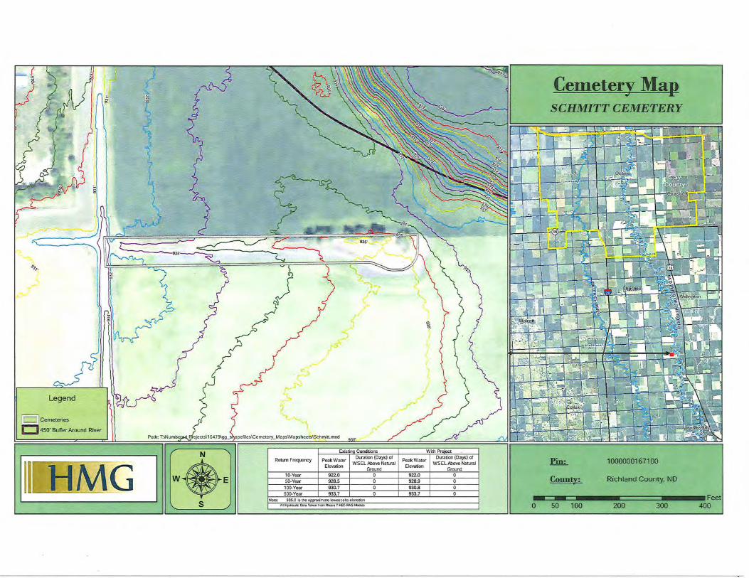
Dear Ms. , Schmitt Cemetery:
It has come to our attention you may be concemed with potential impacts to cemeteries upstream of the staging area of the proposed Fargo-Moorhead Metropolitan Flood Risk Management Project (Project). We hope the enclosed information is useful to you. As explained fmiher below, your cemetery will experience no water depth from the Project.
In September of2013, after the Supplemental Environmental Assessment for the Project was finalized, the St. Paul District, U.S. Army Corps of Engineers (Corps) and the Fargo-Moorhead Diversion Authority (Sponsor) gathered infmmation from various map and air photo sources, through interviews with cemetery representatives, and during on-site visits to cemeteries on both sides of the Red River from Georgetown, Minnesota, in the north to Abercrombie, Nmih Dakota and McCauleyville, Minnesota, in the south. The purpose of this effmi was to get a better understanding of potential Project impacts and benefits to cemeteries in the region, to identify potential mitigation measures that could be used to offset Project impacts, and to fmm a general understanding of existing flooding issues associated with regional cemeteries.
Based on that information, a Cemetery Study Repmi was prepared which lists (1) cunent and potential impacts to the cemeteries from flooding, (2) current and anticipated clean-up efforts after flooding, and (3) mitigation options to remedy or prevent potential Project-related impacts. The report also includes maps showing the approximate size and location of each of the 54 cemeteries identified as pmi of the study and gives water elevations and duration of water above natural ground level both with and without the Project in place for the 1 0-year, 50-year, 100-year, and 500-year flood events. The complete Cemetery Study Repmi is posted on the Sponsor's website at www.fmdiversion.com.
Enclosed is a map with water elevation and duration infmmation for the Schmitt Cemetery from Attachment 1 of the Cemetery Study Repmi. At the 100-year or 1-percent chance flood event, there is no change in water elevation between the without Project and with Project conditions. The same is true for 10 ofthe other 15 cemeteries upstream ofthe Project staging area.

The next step is to develop mitigation plans in consultation with the seven cemeteries in the staging area and the four cemeteries upstream of the staging area which may be impacted by the Project. The Corps' goal is to develop an actual site-specific Mitigation Plan within a year. It is important to note that actual implementation of any mitigation will be completed prior to the completion of the Project.
Once again, the Schmitt Cemetery will experience no direct impacts from the Project and therefore will not be included in a mitigation plan. We hope this information is useful to you. The point-of-contact for this action is Mr. Jon Sobiech, PD-Environmental, U.S. Army Corps of Engineers, St. Paul District, 180 Fifth Street East, Suite 700, St. Paul, MN 55101-1678, phone (651) 290-5428 or by email at [email protected].
Enclosure Site-specific cemetery map
Sincerely,
Teny J. Birkenstock Deputy Chief, Regional Planning and
Environment Division North
.9J>_,.
J /'-'
(c::::JJ cemeteries
t::J450' Buffer Around River
III[H=M(i I w •• s
r. .. ,-/
{
r /
Return Frequency Peak Water '"''-'ICUUII \'"'CJ;;;>) Ul
WSEL Above Natural Elevation
Ground 10-Vear 922.0 0 50-Year 928.5 0
100-Vear 930.7 0 500-Vear 933.7 0
Note: 935.0 Is the opproldmnte lowest si te cle\CI!Ion AI! Hydrnu~c l:bto Tol<on from Rloso 7 HEC-RAS Mxlats
-e, "'
Peak Water
Elevation 1 Ground
922.0 0 928.9 930.8 933.7
Cemetery Map ... SCHMITT CEMETERY
»=-.!.....!A!L
County:
1000000167100
Richland County, NO
- - Feet 0 50 100 200 300 400
REPLY TO ATIENTION OF
DEPARTMENT OF THE ARMY ST. PAUL DISTRICT, CORPS OF ENGINEERS
180 FIFTH STREET EAST, SUITE 700
ST. PAUL, MN 55101-1678
June 27, 2014
Regional Planning and Environment Division North
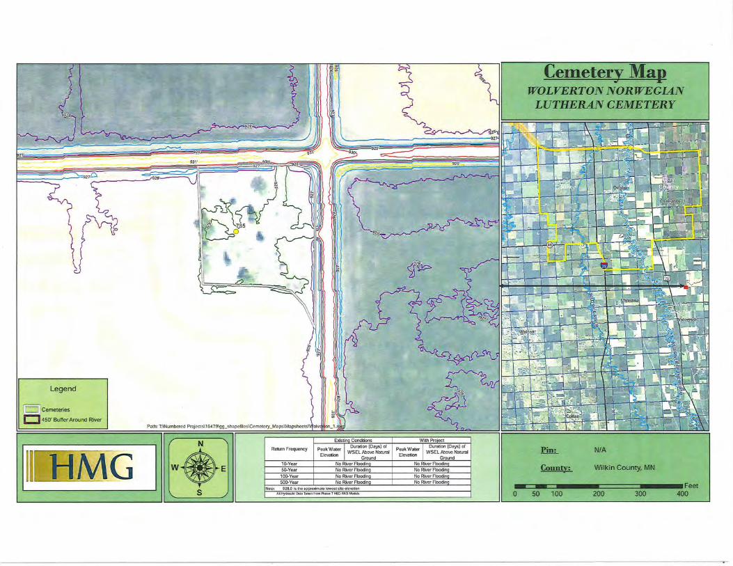
Dear Mr. Wolverton Norwegian Lutheran Cemetery:
It has come to our attention you may be concerned with potential impacts to cemeteries upstream of the staging area of the proposed Fargo-Moorhead Metropolitan Flood Risk Management Project (Project). We hope the enclosed infmmation is useful to you. As explained futiher below, your cemetery will experience no water depth from the Project.
In September of2013, after the Supplemental Environmental Assessment for the Project was finalized, the St. Paul District, U.S. Army Corps of Engineers (Corps) and the Fargo-Moorhead Diversion Authority (Sponsor) gathered infmmation from various map and air photo sources, through interviews with cemetery representatives, and during on-site visits to cemeteries on both sides of the Red River from Georgetown, Minnesota, in the north to Abercrombie, Nmih Dakota and McCauleyville, Minnesota, in the south. The purpose of this effmi was to get a better understanding of potential Project impacts and benefits to cemeteries in the region, to identify potential mitigation measures that could be used to offset Project impacts, and to fmm a general understanding of existing flooding issues associated with regional cemeteries.
Based on that information, a Cemetery Study Report was prepared which lists (1) current and potential impacts to the cemeteries from flooding, (2) current and anticipated clean-up effmis after flooding, and (3) mitigation options to remedy or prevent potential Project-related impacts. The repmi also includes maps showing the approximate size and location of each of the 54 cemeteries identified as part of the study and gives water elevations and duration of water above natural ground level both with and without the Project in place for the 1 0-year, 50-year, 100-year, and 500-year flood events. The complete Cemetery Study Repmi is posted on the Sponsor's website at www.fmdiversion.com.
Enclosed is a map with water elevation and duration infmmation for the Wolvetion Norwegian Lutheran Cemetery from Attachment 1 ofthe Cemetery Study Repmi. At the 100-year or!percent chance flood event, there is no change in water elevation between the without Project and with Project conditions. The same is true for 10 of the other 15 cemeteries upstream of the Project staging area.
The next step is to develop mitigation plans in consultation with the seven cemeteries in the staging area and the four cemeteries upstream of the staging area which may be impacted by the Project. The Corps' goal is to develop an actual site-specific Mitigation Plan within a year. It is important to note that actual implementation of any mitigation will be completed prior to the completion of the Project.
Once again, the Wolverton Norwegian Lutheran Cemetery will experience no direct impacts from the Project and therefore will not be included in a mitigation plan. We hope this information is useful to you. The point-of-contact for this action is Mr. Jon Sobiech, PDEnvironmental, U.S . Army Corps of Engineers, St. Paul District, 180 Fifth Street East, Suite 700, St. Paul, MN 55101-1678, phone (651) 290-5428 or by email at [email protected].
Enclosure Site-specific cemetery map
Sincerely,
Teny J. Birkenstock Deputy Chief, Regional Planning and
Environment Division North
Legend
"O J Cemeteries
c:J 450' Buffer Around River Path: T:\Numbered Projects\ 1 64 79\gg _shapefilcs\Cemctcry_Ma ps\Mapsheets\'
N Return Frequency
w E 10-Year
50-Year
100-Year 500-Year
s Note: 928.0 Is !he opprollimtltc towcstslta clcwtlon AIHydrllulk: DIUI ToiWn fromf'twr.>e 7 t£C.RAS ~
Cemetery Map ... WOLVERTON NORWEGIAN
LUTHERAN CEMETERY
Pin: N/A
Conn tv: Wilkin County, MN
300 •~~ .. == ........ ~~====~~ .... ~~Fe~ - - 400 0 50 100 200