Embed Size (px)
Citation preview

Boulder County’s Agricultural Heritage
Prepared for:Boulder County Parks & Open Space
Departmentand
Boulder County Land Use Department
By:
Deon Wolfenbarger
March 10, 2006
TABLE OF CONTENTS
Introduction . . . . . . . . . . . . . . . . . . . . . . . . . . . . . . . . . . . . . . . . . . . . . . . . . . . . . . . . . . . . . . . . . 1
Historic Agricultural Contexts . . . . . . . . . . . . . . . . . . . . . . . . . . . . . . . . . . . . . . . . . . . . . . . . . . 3 Early Settlement/Pioneer Agriculture: 1859-1896 . . . . . . . . . . . . . . . . . . . . . . . . . . . . . 5Growth in Agriculture: 1897-1919 . . . . . . . . . . . . . . . . . . . . . . . . . . . . . . . . . . . . . . . . . 18Retrenching and New Directions in Agriculture: 1920-1967 . . . . . . . . . . . . . . . . . . . . . 27
Historic Agricultural Property Types . . . . . . . . . . . . . . . . . . . . . . . . . . . . . . . . . . . . . . . . . . . 36Farms, Ranches, Agricultural Districts and Rural Cultural Landscapes . . . . . . . . . . . . 37Farm house, ranch house, or worker housing . . . . . . . . . . . . . . . . . . . . . . . . . . . . . . . . . 39Barns and secondary outbuildings . . . . . . . . . . . . . . . . . . . . . . . . . . . . . . . . . . . . . . . . . . 42Feed storage and processing resources . . . . . . . . . . . . . . . . . . . . . . . . . . . . . . . . . . . . . . 46Food storage and processing resources . . . . . . . . . . . . . . . . . . . . . . . . . . . . . . . . . . . . . 50Watering facilities, windmills, and irrigation resources . . . . . . . . . . . . . . . . . . . . . . . . . 52Agricultural landscape features . . . . . . . . . . . . . . . . . . . . . . . . . . . . . . . . . . . . . . . . . . . . 54Granges and agricultural society buildings . . . . . . . . . . . . . . . . . . . . . . . . . . . . . . . . . . 56
Summary . . . . . . . . . . . . . . . . . . . . . . . . . . . . . . . . . . . . . . . . . . . . . . . . . . . . . . . . . . . . . . . . . . . 57
Appendices . . . . . . . . . . . . . . . . . . . . . . . . . . . . . . . . . . . . . . . . . . . . . . . . . . . . . . . . . . . . . . . . . 58Boulder County Ditches . . . . . . . . . . . . . . . . . . . . . . . . . . . . . . . . . . . . . . . . . . . . . . . . . . 59Boulder County Landmarks with agricultural associations . . . . . . . . . . . . . . . . . . . . . . 64Centennial Farms/Ranches in Boulder County . . . . . . . . . . . . . . . . . . . . . . . . . . . . . . . . 66
Bibliography . . . . . . . . . . . . . . . . . . . . . . . . . . . . . . . . . . . . . . . . . . . . . . . . . . . . . . . . . . . . . . . 67
Cover photos:
Top left - Cito Barn on Mineral Road
Bottom right - Scates Ranch on Magnolia Road
Som e of the agricultural resources pictured in this document
are on private property, and are not open for public viewing.
1
INTRODUCTION
Boulder County has a rich agricultural heritage. From its beginnings in the 1860s providing foodsupplies for the mining camps to the large wheat farms and beet fields of the early twentiethcentury, Boulder County agriculture is noted for its diverse history. Unfortunately, over the pastseveral decades numerous historic agricultural properties have been lost or are under threat due toincreasing property values and development pressures. In addition to increased developmentpressures, the way in which Boulder County is farmed is changing. Due in part to open spaceacquisitions of agricultural properties, the once prevalent farm family living and working on theirland has been replaced in many cases by an agricultural lease agreement to an off site tenant. Thisrelatively new arrangement has eliminated the need for some of the historic agricultural buildingsonce necessary for the resident family farmer.
In order to plan for the protection and preservation of historic agricultural resources, they mustfirst be inventoried and evaluated. Boulder County recognized this responsibility nearly twodecades ago by focusing on historic agricultural resources as part of its overall historic sitessurvey plan to inventory all buildings 50 years of age and older in unincorporated areas of thecounty. This aggressive agenda has resulted in Boulder County accumulating a large inventory ofsurveyed agricultural properties and plans for future survey phases. This accumulated surveydata provides a sufficient basis of knowledge of the number, location, and significance of historicagricultural. However, an understanding of the how these agricultural resources came into being,how they functioned, and how they changed over the years is necessary in order to properlyevaluate them. It is therefore the goal of this document to take a comprehensive look the historyof the development of Boulder County’s agriculture.
Project DescriptionThis document is part of Boulder County Parks and Open Space’s 2005 Certified LocalGovernment grant to research and write a countywide agricultural historic context, prepare aNational Register Multiple Property Documentation Form, develop local landmark eligibilityguidelines for agricultural related properties, and to evaluate completed survey forms foragricultural properties in order to develop a list of eligible properties based upon the contextfindings.
Funding, personnel, and project datesThe project was funded in part with federal funds from the National Historic Preservation Act,administered by the National Park Service, U.S. Department of the Interior and for the ColoradoHistorical Society. However, the contents and opinions do not necessarily reflect the views orpolicies of the U.S. Department of the Interior or the Society, nor does the mention of tradenames or commercial products constitute an endorsement or recommendation by the Departmentof the Interior or the Society. This program receives federal funds from the National ParkService; regulations of the U.S. Department of the Interior strictly prohibit unlawfuldiscrimination in departmental federally assisted programs on the basis of race, color, nationalorigin, age or handicap. Any person who believes he or she has been discriminated against in any

2
program, activity, or facility operated by a recipient of federal assistance should write to:Director, Equal Opportunity Program, U.S. Department of the Interior, National Park Service,1849 C Street, N.W. Washington, D.C. 20240.
In August 2005, Boulder County contracted with Deon Wolfenbarger of Three GablesPreservation to complete the multiple segments of the Certified Local Government project. Carol Beam, Historic Preservation Specialist, served as project coordinator for Boulder County. Dan Corson, Intergovernmental Services Director, served as grant coordinator for the ColoradoHistorical Society and Dale Heckendorn, Preservation Planning Coordinator and State andNational Register Coordinator, served as project reviewer for the Colorado Historical Society.
3
HISTORIC AGRICULTURAL CONTEXTS
This report is organized around the built resources and historic landscapes that resulted fromagricultural activities in Boulder County, Colorado. It provides a context for understanding theconditions that encouraged, hindered, or changed agriculture in the county, and includesinformation on extant resources dating from 1862 through 1950, based on numerous fieldsurveys conducted in unincorporated Boulder County.
The historic contexts cover three major historic periods of agricultural development in BoulderCounty. The Early Settlement/Pioneer Agriculture: 1859-1896 period in Boulder County sawmany major agricultural developments occurring in a relatively compressed time period. In just afew decades, Boulder County went from an Indian hunting ground covered with prairie grasses tobustling mountain mining camps supported by successful farms on the plains. Settlers arrivedshortly after the discovery of gold, broke sod, established farms and ranches, organized and builtirrigation systems, founded farming communities, and organized communal agricultural societiesand county fairs – all in less than thirty years. The next period of agricultural development inBoulder County, Growth in Agriculture: 1897-1919, saw increasing specialization combinedwith the introduction of crops better suited for the climate. This was also a period of growingnational and international markets for Boulder County agricultural products and increasedmechanization in farming. The Retrenching and New Directions in Agriculture: 1920-1967period extended from the end of the first World War through the mid-1960s. Significant changesin farming continued during this period, brought about in part by severe climatic factors andincreasing residential growth in the county. In addition to further specialization andmechanization, new government programs developed for agriculture and soil conservation wereintroduced. Farms grew in size, but decreased in numbers. This last historic period ofagriculture ended when several initiatives, first developed to limit growth in Boulder County, ledto open space protection and purchases. In 1967, the Boulder County Commissioners appointedthe first Parks and Open Space Advisory Committee (POSAC) and the City of Boulder startedtheir Open Space program. Both of these programs would eventually serve to protect agriculturalproperties through the purchase and lease of farm and ranch lands throughout the county. Although these programs may not have initially been conceived to protect agricultural land, theend result was the preservation of thousands of acres of farms through easements and outrightpurchases through the programs initiated in 1967.

4
Figure 1: Map of Boulder County, Colorado showing intergovernmental agreement towns.
Boulder County is located northwest of Denver in the north-central part of Colorado. The countyis set on the eastern slope of the Rocky Mountains, with the Continental Divide serving as itswestern border. The western three-fifths of the county is mountainous, while the eastern portionis rolling plains. Elevations within the boundaries of the county range from 14,000 foot peaks inthe Rocky Mountains to about 5,000 feet on the plains. The county encompasses 741 squaremiles and contains diversified settings, both rural and urban. The county population wasapproximately 214,978 in 2005; about 86,969 of those reside in Boulder, 56,065 in Longmont,15,995 in Lafayette, 14,356 in Louisville and the remainder in the smaller towns of Lyons,Nederland, Ward, Jamestown, Superior and Erie and unincorporated areas, which include thecommunities of Niwot, Gunbarrel and Allenspark. Native Americans were the first to inhabit thearea; the Utes were long-time residents of the “Shining Mountains,” followed later by theCheyenne and Arapaho Indians who hunted in the Boulder and St. Vrain valleys prior to thearrival of the first Euro-American settlers. The discovery of gold led to the first town, BoulderCity, being laid out in March 1859. The Colorado Territory was created in 1861, and Boulderwas one of the first seventeen counties.

1Sanford Charles G ladden, Boulder Firsts: A Source-Book of Beginnings in Boulder, Colorado (N.p: pre-
publication photocopy of manuscript prepared by Boulder Genealogical Society, 1972) 598.
2Ibid., 601.
5
Early Settlement/Pioneer Agriculture: 1859-1896
Prior to 1859, the area that would become the Colorado Territory was so sparsely settled thatthere was little need for agricultural products other than what could be provided by subsistencefarming, i.e., the production by residents for their own immediate or seasonal needs. When goldwas discovered that year, though, the swarm of prospectors into the area created a demand forgreen vegetables, flour, beans, and potatoes, as well as pork, beef, mutton, milk, butter and eggs. The first mining districts in Boulder County organized at Gold Hill and Boulder in early 1859lured thousands of prospectors to the region. The earliest farmers were entrepreneurs who tookadvantage of the growing markets located in the mountain mining camps. The Wellmanbrothers, Henry, Luther, and Sylvanus, are credited with being the first farmers of BoulderCounty. Henry and Luther had searched for gold in California, and like many, did not find theirfortunes there. Hearing of a new strike in Colorado, they brought their youngest brotherSylvanus with them. Upon the advice of Horace Greeley while at Fort Laramie, they headed toGregory and Russell gulches. On August 1, 1859, they reached Boulder valley and “ . . . theyconsidered that they had occasion to go no further, either to find gold, or a rich soil, or a beautifulcountry.”1 The very next day, they purportedly took up a square mile section of land located twoand a half miles east of the mouth of Boulder Creek with Benjamin C. Safford and began to plowan acre for a turnip patch. Although grasshoppers would take this first crop, their lateragricultural ventures were more successful. By fall of 1859, they had completed corrals for theiranimals; by early spring of the next year, the entire section was fenced. As a result, their farmbecame an early boarding center in the county, and anyone who had stock that needed caringused the Wellmans’ pastures.
The Wellmans’ first triumph in farming was with Mountain June potatoes, which producednearly 800 bushels per acre in 1861.2 Encouraged by this success, that same spring they addedgarden vegetables and grains to their crops, including wheat, marking them as the first wheatfarmers in Boulder County. In addition to aforementioned agricultural “firsts,” the Wellmanswere also the first in the county to build a framed barn in 1861. Although they known assuccessful farmers, the Wellmans were subjected to the same variable fates as all others who toilin the soil – the climate and the whims of the market. Grasshoppers would remain a recurringscourge for farmers in Boulder County throughout the years. Prices would always fluctuate, butespecially so in this early period, with seed potatoes bringing in 15 cents per pound one year, andthe next spring only yielding a half cent a pound. In general, though, vegetables were greatlyvalued in the mining camps, and these markets proved profitable for produce growers in thesettlement period. In 1865, for example, a single large cabbage could bring ten dollars. In the1860s, large oxen trains taking loads of vegetables from the valleys of the Boulder and St. Vraincreeks up into the mining towns of the Rocky Mountains were common sights. Sometimes large

3Ibid., 599-602; Anne Dyni, Pioneer Voices of the Boulder Valley: An Oral History (Boulder, CO: Boulder
County Parks and Open Space Department, 1999) 1.
4Phyllis Smith, A Look at Boulder from Settlement to City (Boulder, CO: Pruett Publishing Company,
1981) 25.
5“Letter from Boulder City, Colorado Territory,” Small Documents Collection (Boulder, CO: Carnegie
Branch Library for Local History, Boulder Public Library System, 1863).
1863.
6Richard Fetter, Frontier Boulder (Boulder, CO: Johnson Publishing Company, 1983) 151.
6
parties of miners would also come down from Gold Hill and other areas to the Wellmans’ farmto get a vegetable dinner.3
Most of the early farmers came to Boulder County for the same reason as the Wellmans – gold. Unlike the Wellmans though, who immediately turned to farming, most of the new arrivals triedtheir hand for a while at gold mining. Unfortunately not all were able to make a living, andfewer still found their fortunes. Many disappointed “go-backers” eventually packed up and wentback to the states. Several others decided to stay, though, and they returned to the type of life andwork that they knew best – farming. Some of the other early agrarians in the county during thisperiod included Andrew Douty, who planted wheat and potatoes along South Boulder Creek. Perry White was one of the earliest to plant wheat along the St. Vrain in the northern part of thecounty, using seed brought from Salt Lake City.4
A letter from “Boulder City, Colorado Territory” in 1863 shows the reasons for the change ofheart many of the emigrants, who had first come to the area for mining, had towards farming.
jesse farming here pays big. You bet wee Can make money other ways butfarming is A shore Shot and A fast way to make money here. . . Wheat is onemain point. . . They rased the best wheat here last year I ever see grow. Jesse youwould knot know this Country although you was here in 60, you know that weethought they couldn’t be any thing rased here but wee was misstaken.5
Vegetables and grain crops were not the only profitable agricultural commodities desired by theresidents of the mining camps; fresh meat was also in short supply during the settlement period. One of the earliest ranchers in Boulder County who profited from this market was AnthonyArnett. Born in Alsace-Lorraine in 1819, Arnett was first drawn to the western United States bythe gold rush in California. Striking out there, he moved on to Pike’s Peak in 1859. Impressedwith the mild winter climate in the area around Boulder City, Arnett decided to winter cattlehere. He drove nearly one hundred heifers across the plains in the spring of 1860 and beganranching in the area.6 Arnett was typical of many early cattle operations which utilized the opengrasslands in the winter, and then drove the cattle to mountain pastures every spring for fattening. Other ranchers operated small feedlots instead and used the abundant prairie grasses for hay. Infact, the harvesting of native prairie grasses as hay for the gold camps in the mountains of

7Dyni, 59-60.
8Smith, 27.
7
A stock certificate from the Boulder and White Rock Ditch
Company, founded in 1873 to deliver water to Boulder and
Weld county farmers. From the Boulder & White Rock Ditch
& Reservoir Co. webpage <http://www.ditchcompany.com>
western Boulder County was likely one of the earliest agricultural activities in the area. The draftanimals working in the mines created a ready market for prairie hay. So in spite of its abundanceon the plains, hay generally brought extremely high prices in the mountains. Farmers mightreceive $25 a ton for hay in the fields down on the plains, but the freighters who delivered it tothe mountains made the most profit, sometimes selling a load for as much as $300-$500 a ton.7
Some of the early attempts in farming in the county were not always successful. Marinus Smithand Joseph Wolff thought that the slopes along the foothills might be right for growing a widevariety of fruits. They experimented with plots of strawberries, raspberries, and blackberries, aswell as groves of apple trees and acres of grapevines. Boulder County fruit growers evenconsidered the possibility of vineyards for table wines. When not plagued by the numerousgrasshopper infestations, however, the dry winters in Boulder County proved problematic forgrowing fruit on the Front Range slopes.8
While not all of Marinus Smith’s earlyventures were “fruitful,” he did realize thatthe key for successful agriculture inBoulder County was water. Some parts ofthe county were fortunate to haverelatively reliable water sources, throughthe two Boulder creeks as well as the St.Vrain, Left Hand, and the LittleThompson. The first agriculturalsettlements were naturally confined to landnear these creeks. After all the wateredland was taken up in claims, however, itwas clear to newly-arrived farmers that therainfall in semi-arid Colorado was notadequate for most agricultural activities,particularly in the spring when most cropswere started. Taking cues from irrigationsystems they learned about while at theCalifornia gold strikes, farmers developed a network of irrigating canals in order to provide themwith water necessary for their crops and livestock. Smith and Pell dug one of the first irrigationditches around Boulder in 1859. Following their lead, other ditches were dug throughout theplains to catch the spring runoff from the mountain snows in the Boulder and St. Vrain valleys. In 1860, the Howard and Anderson ditches were dug. By 1862, the Farmers Ditch was sevenmiles long and had an irrigation capacity of 1,500 acres. Numerous other ditch companies werequickly organized in order to provide water for farmers; a list of Boulder County ditches is found

9Betty Ann Newby, The Longmont Album: History and Folklore of the St. Vrain Valley (Virginia Beach,
VA: Donning Company Publishers, 1995) 26.
10Diane Goode Benedict, Refuge in the Valley: 1800s Pella, Colorado (Lyons: CO: Applications P lus,
2004) 17-18.
8
in Appendix A. While many of these ditches involved the cooperation of several farmers, somewere developed privately. German immigrant George Zweck came from Omaha in 1860 as partof a 300 ox-team wagon train. After viewing the St. Vrain Valley from Burlington, he decided totake up farming in the lush grassland along the creek. He laid out and dug his farm’s irrigationsystem by hand. Reversing the trend of miner turned farmer, Zweck decided later to prospect forgold in the summers and became Jamestown’s first settler. He returned to his first love,agriculture, by invested his mining earnings in land and purebred Hereford cattle.9
Towards the end of this period, Colorado’s water policy was formalized through a state supremecourt case that was settled in 1892. When George Coffin's corn on the St. Vrain Creek diedbecause the Left Hand Ditch Company diverted the upstream water into Left Hand Creek, Coffintook the ditch company to court. The Court ruled in favor of the Left Hand Ditch Company,which had prior water rights, stating that the company's right to divert water was superior toCoffin's claim. More importantly, the Court upheld the ditch company's right to divert water intoa different drainage system. This case set a precedent in water law, and became known as the"first in time, first in right" or "prior appropriation" water doctrine.
Although the gold camps would continue to lure new settlers, two developments would make thearea around Boulder County more inviting for agriculture. First, the Territory of Colorado wascreated on February 28, 1861. A year later, President Lincoln signed the Homestead Act. Thelatter encouraged new settlers to head west to look for new farm lands instead of gold. TheHomestead Act allowed any head of household to claim a 160-acre parcel of land if he (or she)was at least 21 years old. A temporary claim was filed at a land office for a small fee andpresentation of survey coordinates. Next, the homesteader was required to live on the land forfive years and make improvements. “Proving up” ownership required building a home andfarming the land. Emigrants from the East and Midwest, who were looking for farm land of theirown, took up a majority of the land patents. Occasionally, eastern land developers hiredrepresentatives to live on the acreage, later purchasing the land for little cost.
Although many of the new emigrants were individuals looking for a chance to settle down tofarming or ranching, some came out west in organized groups. Members of the Dunkard Churchin Pella, Iowa, were finding that good farm land was becoming too expensive for theircongregation. Tales of free, rich bottomland near the Rocky Mountains lured several to emigratefrom Iowa to Boulder County’s St. Vrain Valley. They formed a community in 1887 which theynamed for their hometown in Iowa. The new town of Pella was located on the banks of the St.Vrain, about four miles west of Burlington, and was an early agricultural community in northernBoulder County.10

11Dyni, 29.
12Newby, 29.
9
Lutheran Church in Ryssby, the first Swedish settlement in the
state, ca. 1932-1940. Call number: X-13248; photo by
Muriel Sibell Wolle, courtesy of Western History/Genealogy
Dept., Denver Public Library.
Not only were emigrants from the UnitedStates tempted to move to the ColoradoTerritory, but the Homestead Act waswidely promoted abroad as well. ManyEuropeans were as eager as others toobtain free farmland in Boulder County,and consequently founded several smallfarm communities in this period. Ryssbywas the first Swedish settlement in theColorado Territory. In 1869, Sven JohanJohnson and others from Sweden’sSmåland province established claimsunder the Homestead Act, and were soonjoined by their families and other Swedishimmigrants. Early farming effortsprovided a meager living, so to augmenttheir incomes, many of the men had tohire out or work as miners andlumberjacks.11
Not all immigrants founded communities, but many began very successful agriculturalenterprises. Some arrived before the Homestead Act of 1862, but took advantage and laid claimslater. Swiss immigrants Frederick and Jacob Affolter first arrived in Boulder County in 1860. They decided to sell cheese in the mining camps, and consequently drove a herd of milk cows allthe way from Missouri to their Left Hand Creek claim just west of Haystack Mountain in 1862. They opened the first cheese factory in Boulder, and their cabin built in the “Swiss style” becamea local gathering place.12
Regardless of their origins, the new settlers had to build some type of home and plant crops ontheir 160-acre homestead. The first task facing settlers in the new territory was to provide shelterfor themselves and their families before winter arrived. The lucky ones were able to move anunused cabin from Boulder City out onto the plains, stake their fields, and begin plowing. Ifwood could be brought down from the mountains, the settlers were able to construct log cabinswith various methods of log construction. Small wooden “claim shanties” also served as homefor many settlers during their first year or two on their claims. These were constructed fromboard-and-batten milled lumber with wood shake roofs. Some dwellings were made of nativestone, principally sandstone. Settlers on the prairies also dug “bricks” of sod and built sodhouses. These “soddies” were warm in winter and cool in summer, but were ridden with spidersand bugs. After rainfall, the family also had to bail water out of the house. Another version of a

10
Early crude agricultural buildings near the settlement of Altona, including a barn and log outbuilding and fences.
Photo ca. 1942 by Muriel Sibell Wolle. Call number: X-5412, courtesy of Western History/Genealogy Dept.,
Denver Public Library.
sod house was the dugout. This type of shelter was made by digging into a hill or bank, thenbuilding up the front and side walls with sod. The roofs were made of poles covered with canvasand sod or lumber.
After shelter, water and food were the next concern. Initially water was hauled from creeks orsprings. Muddy runoff, diseases, seasonal low flow, or drought made this an unstable source. Consequently most early settlers dug water wells as soon as possible. The earliest farmers alsohad to be relatively self-sufficient for their food. Most brought with them a milk cow, a hog ortwo, and some chickens or turkeys. These families had milk, butter, eggs, lard, and some freshmeat, although wild game also provided meat. The farm garden later provided potatoes, melons,turnips, and cabbage. Associated with this period, then, were typical (if rough) agriculturalbuildings and structures, such as barns, corn cribs, hog houses, poultry houses, granaries, rootcellars, and storage buildings, as well as irrigation ditches and canals. Many of the earliest farmbuildings from the settlement period in Boulder County have been lost, in part due to their age,original construction methods, and changing farm sizes and functions; there is littledocumentation about the layout or arrangement of the buildings on the farms from this era.
Once shelter and the immediate need for food were settled, the homesteaders had to tackleplowing and getting in their crops. The tough prairie grasses with deep root systems andgenerally substandard plows caused many to take more than two years to clear their land in the

13Although Colorado was not admitted to the union until 1876, the federal government still collected
agricultural data for the region. The county figures were gathered for the original seventeen Colorado counties.
141870 U.S. census, Boulder County, Colorado, agriculture schedule; cited from: University of Virginia
Library, Geospatial and Statistical Data Center, Historical Census Browser
<http://fisher.lib.virginia.edu/collections/stats/histcensus/> cited 10 October 2005.
151880 and 1890 U.S. census, Boulder County, Colorado, agriculture schedule; cited from: University of
Virginia Library, Geospatial and Statistical Data Center, Historical Census Browser <http://fisher.lib.virginia.edu/
collections/stats/histcensus/> cited 10 October 2005.
16Dan Corson and Tom N oel, Boulder County: An Illustrated History (Carlsbad, CA: Heritage M edia
Corp., 1999) 82.
11
plains, while in the mountains, farmers had to contend with steep topography, rocks and bouldersin addition to the shortened growing seasons. These factors led more than a few to conclude thatfarming in the West was too difficult. In general, though, farmers and ranchers in BoulderCounty were relatively successful compared to others in Colorado in these early years. By 1870,even though Boulder County was one of the smaller counties in the territory in acreage and hadonly 1,939 residents, it was ranked second for acres of improved farm land, with 14,365improved; an additional 28,308 were considered “unimproved.” Furthermore, the value of itsfarmlands was the highest in the territory in 1870 at $575,650.13 The total estimated value of allfarm productions in the county was $326,313. There was a total of 232 farms recorded in thiscensus, with only a few small farms – 19 farms ranging in size between 3-9 acres. There were 26farms with 10-19 acres, 80 farms 20-49 acres, 58 farms 50-99 acres, and 49 farms 100-499 acres. No farms larger than 500 acres were recorded in the 1870 census. There were also no recordedvalues for orchard or other produce market gardens, but a total of $11,734 of slaughteredanimals.14 By 1880, Boulder County had the largest amount of improved land in farm acreage inthe state at 82,990 acres; again, this was in spite of being one of the smaller counties in totalacreage, and with much of it encompassed by mountains. The amount of improved acreageincreased in 1890 to 93,155 acres, although Boulder was now ranked fourth behind Arapahoe,Larimer, and El Paso counties.15
The heritage of Boulder County agriculture during this settlement period is illustrated by manysuccesses. Many of the rural agricultural settlements grew into small communities, includingNiwot, Pella, Valmont, Ryssby, Altona, and Burlington. Several flour mills were established toprocess the successful wheat crops of the county. In fact, Boulder County wheat was purportedlyresponsible for the site selection of the town of Longmont. The Chicago-Colorado Colony,which first organized in Chicago 1870, proposed founding an agricultural community in theColorado territory. The colony’s belief in the ideals and benefits of agriculture was laid out in aconstitution written that year.
Agriculture is the basis of wealth, of power, of morality. It is the conservativeelement of all national and political and social growth; it steadies, preserves,purifies and elevates.16
17Ibid., 82, 86.
18“Records and Correspondence 1872-1873 of Boulder County Agricultural Society,” BHS 328 b043 f01
(Boulder, CO: Carnegie Branch Library for Local History, Boulder Pub lic Library System).
19Dyni, 55.
12
The colony sent a committee to look for suitable sites in the land grant area of the Denver PacificRailway. They happened upon Enoch J. Coffman, who was delivering his Boulder County wheatcrop to Denver. Delighted with what they saw, the committee decided to purchase approximately60,000 acres of land in the county, and subsequently laid out the town of “Longmont” in 1871. About 390 members of the colony moved to Longmont that first year, where they were allowedto purchase two town lots and given access to outlying farm lands. Communal irrigation ditcheswere built within the town by the members of the colony. Coffman was appointedsuperintendent of the agricultural operations, where he oversaw 1,000 acres planted in wheat andother crops.17
With the growing numbers of farmers and their increasing success, agriculture in Boulder Countydid not remain at the pioneer or “subsistence” level very long. Within a decade, county agrariansrealized the need to meet for the purpose of sharing information and working for the bettermentof the industry. The Boulder County Agricultural Society was organized on June 12, 1869. Although there was no money in the treasury, the group nonetheless purchased fair grounds andorganized a county fair, all within a few months of organizing. They purchased forty acres ofland with a note and a loan from the owner, Mrs. Susan Branch, and others. A fence wasimmediately built around the grounds, and a temporary round house, judges’ stand, stalls, track,and other improvements were made. The first fair was held for four days commencing October13, 1869.18 In spite of numerous attractions, including daily races and even a mining exhibit, thefirst fair lost money. Perhaps more important than the showcasing of agricultural wares duringthis first county fair was the farmers’ convention that was held at the same time. Farmers fromLarimer, Weld, Jefferson, and Arapahoe counties, as well as Boulder County held a farmers’convention to discuss “the protection of farmers against depreciating prices of farm products byspeculators.”19
Just a few years earlier in 1867, the National Grange movement had organized in Washington,D.C. Officially known as the Patrons of Husbandry, the organization worked to unite farmersand work for their betterment. It was the first fraternal organization to allow women to holdoffices, and would soon grow to be as important for its social outlets as for its political activities. In Colorado, though, the grange movement was initiated after the financial panic of 1873 whenfarmers felt the effects of the depression. Hoping to influence favorable agricultural legislationin the new territory, the Colorado Territorial Grange was organized in January 1874. When thestate Board of Agriculture was created in 1876, seven of the eight members were grangers. Theyworked to prevent a plan to divert state funds away from the new agricultural college in FortCollins. In order to keep abreast of legislation affecting farmers, the state grange officers formed
20Ann Dyni, “The Grange M ovement in Boulder County,” (prepared for the Boulder Historic Context
Project, 1992) 4.
21Colorado State Grange, Colorado State Grange History: 1874-1975 (n.p.: Colorado State Grange, 1975)
11.
22Dyni, “The Grange Movement,” 4.
23Ibid., 11.
24Corson and Noel, 121.
25Dyni, "Pioneer Voices," 55.
13
a lobbying committee in 1885. They were particularly concerned about potential control ofColorado’s rivers and streams, which would affect the water rights of farmers in the state.20
Boulder County was especially active in the earliest grange efforts in Colorado. Just one monthafter the territorial group formed in January 1874, a special session was held in Boulder City tofurther hone the organization.21 Boulder County and its residents continued to play importantroles in early Colorado Grange history, with several residents filling officer positions.22 John L.Brown of the National Grange was sent to Colorado in 1873, where five of the subordinateGranges he formed were in Boulder County: Valmont Grange #5, Washington Grange #8, LeftHand Grange #9, Harmony Grange #14, and St. Vrain Grange #16. Other Boulder CountyGranges which formed during this early period were: Longmont Grange #27, South BoulderGrange #28, Lower St. Vrain #29, Coal Creek Grange #30, Burlington Grange #31, HaystackMountain Grange #36, Pleasant View Grange #94, Altona Grange #127, Rocky Mountain Grange#128, Longmont Grange #130, Boulder Valley Grange #131, and the Hygiene Grange #134.23
Granges were not the only agricultural societies that organized during the settlement period. In1871, farmers around Longmont formed the Northern Colorado Agricultural Society. Theypurchased an eighty-acre site at Lake Park to serve as their fairgrounds. This fair was sosuccessful that it soon outgrew Boulder’s fair. Eventually, the county fair was moved to theLongmont site.24 The Lower Boulder Farmers’ Club was formed in 1873, and was considered thefirst “club” as opposed to a society.25 The Northern Colorado Horticultural Society was active inthe 1880s, although their scope went beyond the boundaries of Boulder County. The BoulderFruit Growers’ Association aims were based on collectivism, where the fruit growers workedtogether to achieve success. Their incorporation papers, filed on March 4, 1893, stated that theorganization was established:
For the purpose of promoting and encouraging the industry of fruit growing, tosecure fair prices for said fruit, establish a better market and secure better shippingfacilities, to buy, sell and raise the standard of fruit, and have the same reach thecustomer in the best possible condition, to promote the general welfare and securethe best interest of the fruit-growers of Boulder and vicinity, and to lease, erect,

26Gladden, 611-612.
27William J. Convery, III, Pride of the Rockies: The Life of Colorado’s Premiere Irish Patron, John Kernan
Mullen (Boulder, CO: University Press of Colorado, 2000) 100-102.
28Ibid., 105.
29Ibid., 109.
14
acquire by purchase or otherwise a suitable building or buildings and all necessaryreal estate for the same for the use of the Association.26
Many of these organizations were devoted to cooperative marketing of farm products, althoughother coops provided supplies or services. In addition to the grange, other farm organizations,including the Farmers Alliance and the Farmers Educational and Cooperative Union of America(known as the National Farmers Union), also began to promote cooperatives. The rise of interestin cooperatives near the end of the nineteenth century coincided with an agricultural recessionand drought. This factors threatened not only the livelihood of farmers, but a great many of thesmall milling companies in Colorado as well. During the recession, only the larger millingcompanies, such as those owned by J.K. Mullen and Company, seemed able to last through thedifficult economic times. Thus the less stable companies began to talk of consolidation. Analliance had been tried in 1877, the Colorado Millers’ Association and Miller’s MutualProtective Insurance Company (CMA), but it failed in the recession of the mid-1880s. A newmilling association formed in 1885 – the Colorado Milling and Elevator Company (CM&E). Itscharter members included the larger, major mills firms in Ft. Collins, Golden, and Greeley, aswell as the two largest Longmont milling outfits.27 By working under one management, themilling enterprises were able to reduce the expense of manufacturing and obtain better railroadrates, leading to the long-term recovery of the milling industry in the next period of BoulderCounty’s agricultural development.
Most agrarians and small milling companies were not pleased about the development of thelarger commercial milling associations, however. While the larger milling entrepreneurs andassociations were able to barter for better transportation rates, they managed to manipulate thesystem to exclude local farmers from these rates. Furthermore, the CM&E took advantage ofregional price variations and inexpensive shipping rates to import cheap grain from other states. With capital to build large elevators, they could also afford to buy wheat when it was cheap andstore it for future speculations. Colorado farmers could not afford the higher freight rates offeredthem, and were forced to sell to local dealers directly from harvest – the time of the year whenheavy supply forced down wheat prices.28 As a result, many farmers decided to support apatronage-founded mill in order to show their unhappiness with their treatment by the largerCM&E. The Farmers’ Alliance mill, which was suffering during the 1880s, remained profitablefor another thirty-five years due to their support. A second agrarian-based cooperative wasfounded in Longmont in 1886 – the Farmer’s Milling and Elevator Company. Rival millingmogul J.K. Mullen even admitted that this mill was “one of the best–if not the best in northernColorado.”29

30Smith, 33-36.
31Silvia Pettem ,“Roads of the Mountains and Plains,” (Boulder, CO: Boulder Planning Department, 1996)
13-14.
32Ibid., 18.
15
A critical factor in the establishment and later success of agriculture in Boulder County, both forfarmers and processors such as mills, was the development of reliable methods of transportingagricultural products. For the earliest farmers who sold produce to the miners in the mountains,the task of getting their goods to these profitable markets was extremely daunting. Unlike theplains, where a farmer could take a plow and grade a simple road for his own use, agriculturalentrepreneurs alone could not undertake the construction of roads into the mountains. Althoughin the early 1860s the federal government financed the building of a military road up SunshineCanyon, most of the early mountain roads were capital ventures. James P. Maxwell and ClintonM. Tyler capitalized the Boulder Valley and Central City Wagon Road Company of $50,000, andon March 11, 1864, they received a county building permit for road construction up BoulderCanyon. The Wellman brothers were among the subscribers, as they needed to transport theirproduce to the miners living in the various camps.30 For the most part, however, these roadswere financed by parties with mining interests.
Farmers on the plains generally worked on their own roads, following property boundaries basedon the federal township and range system. Citizens could later petition the CountyCommissioners to establish a route as a free county road. The very first county road (now PearlStreet in Boulder) was likely developed to support agriculture, as it led from an intersection inthe fledgling town of Boulder City to Valmont, which was the area’s major agricultural center atthe time. Known then as County Road #1, it was established on April 10, 1862.31 County Road#9 also appears to have been laid out for the benefit of farmers, as it started at Peter Housel’sflour mill in Valmont and extended east to Louisville. Indeed, Valmont’s prominence inagriculture made it the center of several of the earliest county roads, including County Road #10,which today is 63rd Street north of Valmont. County Road #8 extended from just north of thetown of Valmont to today’s Colorado 52 and on to Burlington.32 This was called the “gunbarrel”route because of its straightness; although this route no longer exists, the area still retains thename Gunbarrel.
For the areas without a county road, travel in the plains often involved a dizzying array of zig-zagroutes around the boundaries of varying sized farm fields. In 1866, a New York Tribunecorrespondent traveling from Marshall to Valmont wrote:
We were full two hours in reaching Valmont, on account of the very independenthabits of the Colorado farmers. The second bottoms being devoted to grazingpurposes, they have found it necessary to fence the outer edge of the farm land;and, in so doing, they cut off the road with the most utter disregard of the public. .

33Ibid., 19.
34Ibid., 20.
35Lara, Juliusson, “Boulder County Colorado Major Transportation Routes, Pre 1860 to 1920” (Boulder,
CO: Boulder Planning Department, May 1992) 5.
36Smith, 127.
16
. . In spite of the tedious zigzags we were forced to make, the views of the broad,prosperous, and thickly-settled Boulder region, made our ride very enjoyable. 33
As a Longmont Press editorial in 1874 noted, however,
The farmers are not wholly to blame for fencing up the roads and making peoplezig-zag around two miles, to go a distance of one mile; the most blamable partiesare the County Commissioners.
The newspaper reported of an attempt to build a road from Longmont to Boulder. The route waslaid out, but when a farmer along the route would have suffered “damages,” the Commissionersdecided to abandon the project rather than pay the damages. As a result, it took over eighty yearsfor the “Diagonal” route to finally be built connecting the two towns.34
Although several early Boulder County farmers drove their products into Denver via horse-drawnwagon, many would eventually rely on the railroad for the transportation of their goods. Railservice came to the county in 1873 when two lines were built to serve Boulder City and the Eriecoal mines: the Colorado Central and the Denver and Boulder Valley line. That same year theColorado Central completed a branch line across Coal Creek to the coal mines near Marshall. The coal mines here were also served by the Boulder Valley Railroad line and the Union PacificRailroad.35 Indeed, many of the railroads were initially developed for the mining communities,but would later serve to transport agricultural commodities. The rail lines between the mountainand plains differed in their construction as well as their original purpose. Narrow gauge trackswith rails three feet apart were better able to accommodate the sharp turns in the mountains,while the standard gauge of four feet, eight and a half inches was typically found on the plains.36
Although always susceptible to climatic and economic factors, by and large agriculture in thecounty was very successful up until the 1890s. The settlement period in agriculture providedvirtually all the ingredients needed to make farming successful in Boulder County. Water, themost necessary and precious commodity in Colorado, was obtained through the development ofirrigation companies. Other important developments in the period included the establishment ofseveral rail lines in the county, which opened up far away markets for Boulder Countyagricultural products. Farmers organized and worked to influence farm legislation in the youngColorado Territory. Fairs displayed their crops, livestock, and farm implements, to encourageothers to continue to try their hands at agriculture in Boulder County. Farm communities weresettled and growing; while not all would survive through the next period of agricultural
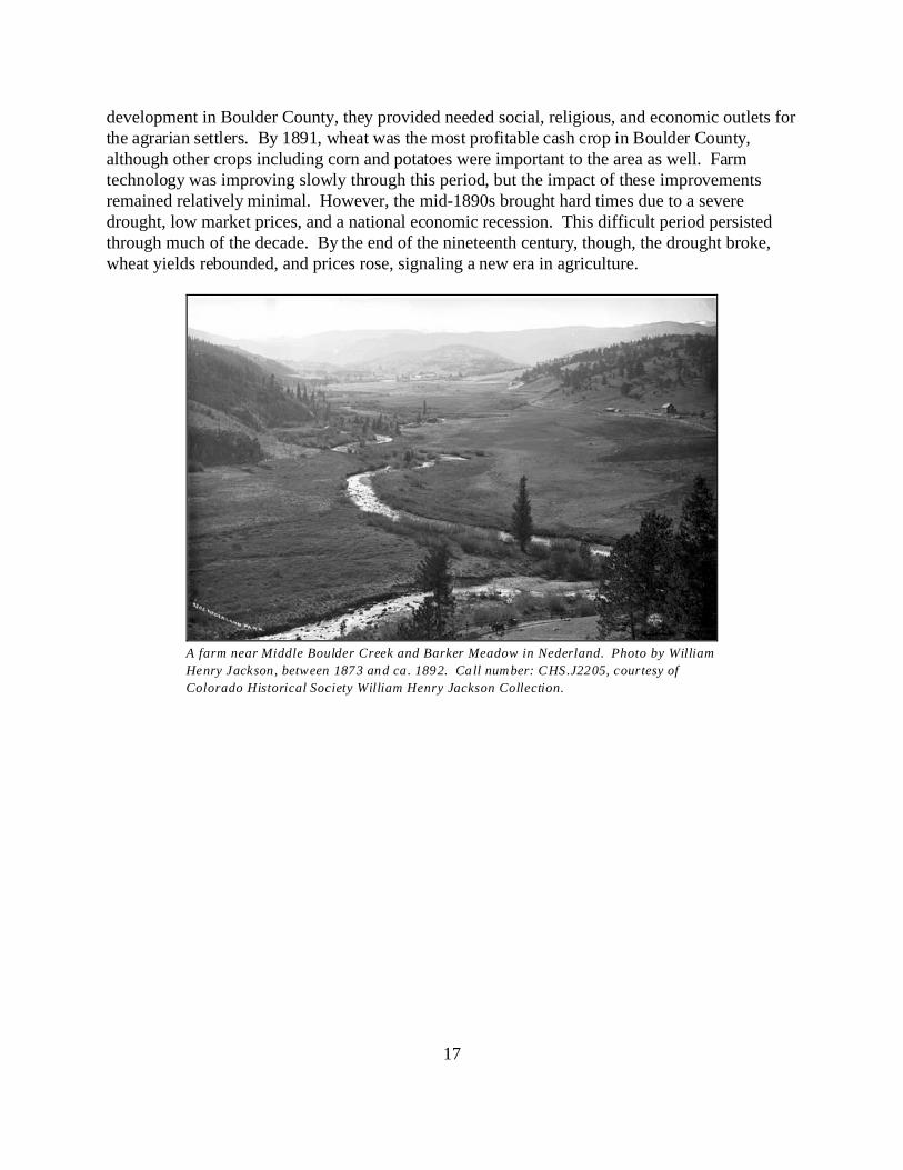
17
A farm near Middle Boulder Creek and Barker Meadow in Nederland. Photo by William
Henry Jackson, between 1873 and ca. 1892. Call number: CHS.J2205, courtesy of
Colorado Historical Society William Henry Jackson Collection.
development in Boulder County, they provided needed social, religious, and economic outlets forthe agrarian settlers. By 1891, wheat was the most profitable cash crop in Boulder County,although other crops including corn and potatoes were important to the area as well. Farmtechnology was improving slowly through this period, but the impact of these improvementsremained relatively minimal. However, the mid-1890s brought hard times due to a severedrought, low market prices, and a national economic recession. This difficult period persistedthrough much of the decade. By the end of the nineteenth century, though, the drought broke,wheat yields rebounded, and prices rose, signaling a new era in agriculture.

18
Profits increased when farmers began to specialize in agricultural production, such as this dairy herd on
the Rough & Ready ditch . Photo ca. 1900, from the Joy Buster collection, courtesy of Diane Benedict.
Illustration of a steel beam John Deere walking plow around 1900, but
more typically used in the mid to late 1800s. Courtesy of John Deere
Company.
Growth in Agriculture: 1897-1919
Several factors combined to help agriculture rebound after the slump experienced in the mid-1890s. Some of these were evident prior to 1890, but they combined around the turn of thecentury to result in a spectacular recovery. These factors included increased specialization,mechanization, the introduction of new or improved crops, improved methods of animalhusbandry, and innovations in farm building construction.
19
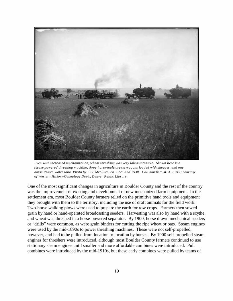
Even with increased mechanization, wheat threshing was very labor-intensive. Shown here is a
steam-powered threshing machine, three horse/mule drawn wagons loaded with sheaves, and one
horse-drawn water tank. Photo by L.C. McClure, ca. 1925 and 1930. Call number: MCC-3045; courtesy
of Western History/Genealogy Dept., Denver Public Library.
One of the most significant changes in agriculture in Boulder County and the rest of the countrywas the improvement of existing and development of new mechanized farm equipment. In thesettlement era, most Boulder County farmers relied on the primitive hand tools and equipmentthey brought with them to the territory, including the use of draft animals for the field work. Two-horse walking plows were used to prepare the earth for row crops. Farmers then sowedgrain by hand or hand-operated broadcasting seeders. Harvesting was also by hand with a scythe,and wheat was threshed in a horse-powered separator. By 1900, horse drawn mechanical seedersor “drills” were common, as were grain binders for cutting the ripe wheat or oats. Steam engineswere used by the mid-1890s to power threshing machines. These were not self-propelled,however, and had to be pulled from location to location by horses. By 1900 self-propelled steamengines for threshers were introduced, although most Boulder County farmers continued to usestationary steam engines until smaller and more affordable combines were introduced. Pullcombines were introduced by the mid-1910s, but these early combines were pulled by teams of

37Dyni, "Pioneer Voices," 71.
381890, 1900 and 1920 U.S. census, Boulder County, Colorado, agriculture schedule; cited from: University
of Virginia Library, Geospatial and Statistical Data Center, Historical Census Browser
<http://fisher.lib.virginia.edu/collections/stats/histcensus/> cited 10 October 2005.
39Norman E. Saul, “Mill Town Kansas in the Age of Turkey Red,” Kansas History: A Journal of the Central
Plains 23 (Spring-Summer 2000): 29.
20
horses, with the forward motion of the machine operating the combine. These were used mainlyin the larger grain fields in the eastern sections of the county.37 By 1920, combines with enginesto run the threshing mechanism were available, but the self-propelled combine was notdeveloped until the 1930s and was not common until the 1940s.
In addition to new machines for sowing and threshing, mechanization for plowing the wheatfields for planting preparation was also introduced during this period. By the mid-1890s, slow-moving steam engines began to replace teams of horses, mules, or oxen. Gasoline-poweredtractors then came into general use ca. 1915, in part due to the loss of farm labor to militaryservice during World War I. The tractor was probably one of the most important innovations infarm machinery, particularly for the cultivation of grain and hay. It pulled a variety of equipmentincluding plows, discs, drills, and combines. To service all this new farm equipment, the numberof implement stores in Boulder County increased dramatically from the 1890s through 1920. While a few Boulder County farmers stubbornly held out and continued to use draft animals,eventually most switched over to machinery as they realized that their neighbors were able tooperate larger farms, till more acreage, and earn greater profits. Thus in spite of the already highpercentage of land already under cultivation, the total amount of acreage in farmland continued toincrease in Boulder County throughout this period, rising dramatically from 93,155 acres in 1890to 191,373 acres in 1900 and 221,202 acres in 1920. A far more spectacular increase in the valueof farm equipment occurred in the same period, nearly doubling from $121,670 in 1890 to$216,340 in 1900 and increasing by 700 percent in 1920 to $1,517,998.38
In addition to advances in farm machinery in this period, new or improved crops wereintroduced. At the beginning of the twentieth century, wheat continued to dominate grainproduction in Boulder County. Before the arrival of the Russian Mennonites, most wheatfarmers tilled small acreage and were limited to the soft wheat varieties. Partly due to the effortsof the Santa Fe Railroad Company to entice immigrants to the United States, an agricultural“revolution” occurred in the late 1870s and 1880s. Russian-Germans, and in particular theMennonites, are generally credited with bringing “hard red winter wheat” with them when theyimmigrated. The promotion and testing of hard wheat varieties were conducted in cooperationwith Mark Carleton of the Kansas State Agricultural College and the U. S. Department ofAgriculture. Together with some Mennonite millers, they proved the adaptability of the“Russian” hard wheat to the plains states in the early 1880s. This hard wheat better survived thewinters on the Great Plains, and because it was harvested earlier in the summer, there were fewerproblems with insects and plant disease than the soft wheat varieties.39 The new varieties of hard

40Corson and Noel, 88.
21
Plains wheat fields with the Flatirons in the
background. Photo by L.C. McClure, ca. 1925 and
1930. Call number: MCC-3048; courtesy of Western
History/Genealogy Dept., Denver Public Library.
Great Western Sugar Company Beet Factory,
Longmont. Photo by L.C. McClure, ca. 1905-1910.
Call number: MCC-349; courtesy of Western
History/Genealogy Dept., Denver Public Library.
red winter wheat were so hard that at firstmillers found them difficult to grind. However,the qualities of this wheat, not the least of whichwere its high yield, were so superior that itpropelled Boulder County to new heights inwheat production after its introduction. Wheatproduction grew even more dramatically duringthe 1910s, when the outbreak of World War Icaused a surge in wheat prices from 76 cents to$4.10 a bushel from 1913 to 1919. Acreageincreased from 1910 to 1920, and productionrose as well. As the grain center of BoulderCounty, Longmont in particular benefited fromthe success of surrounding wheat farmers. Tokeep up with the area’s production, Longmonthad six mills after the turn of the century, andwas proud to be known as the “Minneapolis ofthe Rockies.”40
Longmont was also the center of many otheragricultural enterprises, and benefited from theintroduction of several other crops that werenew to Boulder County; one of the moresignificant was sugar beets. Sugar beets hadbeen grown in northern Colorado since the1890s, but after the turn of the century theybecame one of the most predominate irrigatedcrops in the region. They were relatively easyto grow, in that they were well suited to theclimate and managed to produce well even inadverse weather. The sugar companiessucceeded in promoting of the crop andpersuading Boulder County farmers to switchfrom wheat to sugar beets. Soon there wereenough farmers in the area to justify theconstruction of a refinery for the LongmontSugar Company in 1903, which was acquiredjust a year later by the Great Western SugarBeet Company.
41Ibid., 90.
42Ibid., 88-89.
22
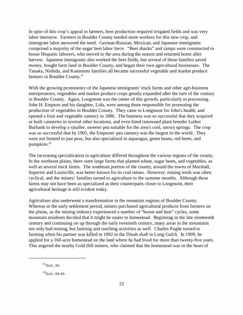
In spite of this crop’s appeal to farmers, beet production required irrigated fields and was verylabor intensive. Farmers in Boulder County needed more workers for this new crop, andimmigrant labor answered the need. German-Russian, Mexican, and Japanese immigrantscomprised a majority of the sugar beet labor force. “Beet shacks” and camps were constructed tohouse Hispanic laborers, who moved to the area during the season and returned home afterharvest. Japanese immigrants also worked the beet fields, but several of these families savedmoney, bought farm land in Boulder County, and began their own agricultural businesses. TheTanaka, Nishida, and Kanemoto families all became successful vegetable and market producefarmers in Boulder County.41
With the growing prominence of the Japanese immigrants' truck farms and other agri-businessentrepreneurs, vegetables and market produce crops greatly expanded after the turn of the centuryin Boulder County. Again, Longmont was the center of this growth, particularly in processing. John H. Empson and his daughter, Lida, were among those responsible for promoting theproduction of vegetables in Boulder County. They came to Longmont for John's health, andopened a fruit and vegetable cannery in 1886. The business was so successful that they acquiredor built canneries in several other locations, and even hired renowned plant breeder LutherBurbank to develop a smaller, sweeter pea suitable for the area's cool, snowy springs. The cropwas so successful that by 1905, the Empsons' pea cannery was the largest in the world. Theywere not limited to just peas, but also specialized in asparagus, green beans, red beets, andpumpkins.42
The increasing specialization in agriculture differed throughout the various regions of the county.In the northeast plains, there were large farms that planted wheat, sugar beets, and vegetables, aswell as several truck farms. The southeast portion of the county, around the towns of Marshall,Superior and Louisville, was better known for its coal mines. However, mining work was oftencyclical, and the miners’ families turned to agriculture in the summer months. Although thesefarms may not have been as specialized as their counterparts closer to Longmont, theiragricultural heritage is still evident today.
Agriculture also underwent a transformation in the mountain regions of Boulder County. Whereas in the early settlement period, miners purchased agricultural products from farmers onthe plains, as the mining industry experienced a number of “boom and bust” cycles, somemountain residents decided that it might be easier to homestead. Beginning in the late nineteenthcentury and continuing on up through the early twentieth century, many areas in the mountainsnot only had mining, but farming and ranching activities as well. Charles Pughe turned tofarming when his partner was killed in 1892 in the Dinah shaft in Long Gulch. In 1909, heapplied for a 160-acre homestead on the land where he had lived for more than twenty-five years. This angered the nearby Gold Hill miners, who claimed that the homestead was in the heart of

43M. M. Anderson, The Mining Camps: Salina & Summerville (Boulder, CO: Junction House, 2005), 287.
44Boulder County Directory, 1896.
45Ernie Betasso, “Oral history interview with Ernie Betasso,” interviewed by John Hess, 15 January 1983.
At Carnegie Branch Library for Local History, Boulder Public Library System, OH0225, Boulder, CO.
46"Boulder Valley, 'The Garden Spot of Colorado," The Daily Camera Industrial Number (8 January 1910).
23
the “richest mining district of the region.” A protest was filed in court, and eventually the federalgrand jury found Charles guilty of giving false testimony that the land did not have any mineraldeposits.43
This conflict between mining claims and homesteaders made it more difficult to establish largefarms in the mountains. Nonetheless, the mountains did see an increase in farming activitiesduring this period. A review of the county directories at the turn of the century reveals severalmountain communities with residents engaged in either farming or ranching in addition tomining, including Altona (farming, stock raising, and fruit growing), Nederland (farming, stockraising), Sugar Loaf (stock raising, mountain farming), and Allenspark. The county directorynoted that at Sugar Loaf, “Farming is made easier than in the valley, owing to the numerous andgentle rain-falls in necessary seasons,” and in Allenspark, “Owing to an abundant supply of rainin proper season and the infallible mountain spring, the native grasses fare well, and areconsequently very productive. Stock raisers are thus enabled to rear cattle at small cost, with anactive demand for their beef.”44
Ernie Betasso’s family history was typical of the development of agriculture in the mountains. Ernie’s father came from Italy to the Pennsylvania coal mines, then onto the coal fields inBoulder County. In the summer when coal consumption was low and the mines were notoperating, Ernie's father prospected in the mountains in quartz, gold, and silver mines. In 1915,his father purchased 160 acres on Sugar Loaf which had been homesteaded by Larry Blanchard,and the family continued farming and ranching activities until the 1960s.45 A more unusualexample of the mining/agriculture relationship in the mountains occurred on Sugar Loaf in 1905,when a farmer harvesting potatoes discovered what would later become the Livingstone mine. Known as the “potato patch strike of 1905," it is likely the only instance in Boulder Countywhere farming activities resulted in an increase in mining. Virtually all aspects of agriculture in the county prospered during the first two decades of thetwentieth century. Due to the wide variety of it agricultural products, the Boulder Daily Cameranewspaper did not believe it was exaggeration to call Boulder Valley "The Garden Spot ofColorado," and the Boulder Commercial Association surely felt the following commentary onBoulder County agriculture was no mere boosterism, but a simple recital of the conditions.46
The farmer is like a king in his own realm, nowhere is this more nearly true thanon the irrigated farms of Boulder County where a failure of crops is almostunknown and nowhere is the farmer in a position to be more independent. To
47Boulder Commercial Association, “Agricultural Possibilities of Boulder County,”(n.p.: Boulder
Commercial Association, n.d. [ca. 1907]. At Carnegie Branch Library for Local History, 300 b01 f12, Boulder, CO.
481910 and 1920 U.S. census, Boulder County, Colorado, agriculture schedule; cited from: University of
Virginia Library, Geospatial and Statistical Data Center, Historical Census Browser
<http://fisher.lib.virginia.edu/collections/stats/histcensus/> cited 10 October 2005.
49Century in the Saddle: The 100 Year History of the Colorado Cattlemens’ Association, (Boulder, CO:
Johnson Publishing Co., 1967) 272-273.
24
those who imagine Colorado as sort of semi-desert, whose people depend almostwholly upon the mines for support, it may be somewhat of a revelation to learnthat the value of Colorado’s agricultural products is greater than her minerals. Boulder County’s agricultural and horticultural products in 1906 amounted to$2,510,839, out of a grand total of $6,497,786 for her combined products . . . . Tothe farmers of the east and middle west, our untilled soils seems poor andunproductive, but with the magic touch of water and Colorado sunshine, theybecome the most productive in the world.47
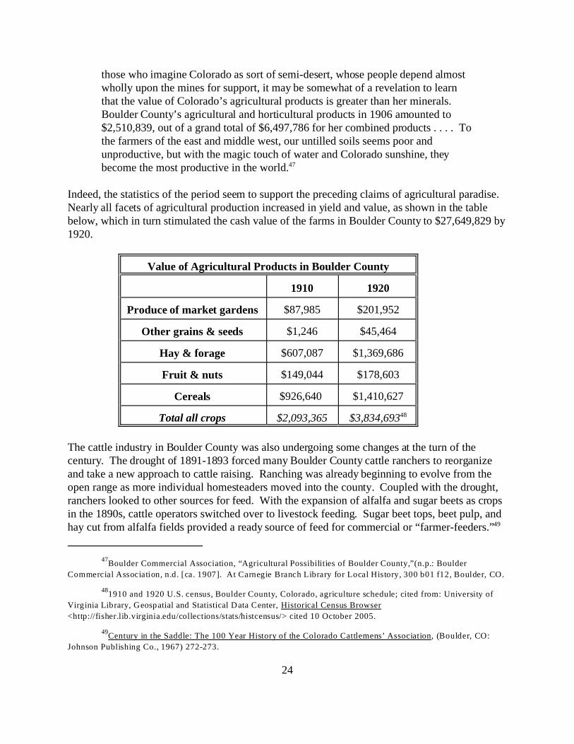
Indeed, the statistics of the period seem to support the preceding claims of agricultural paradise. Nearly all facets of agricultural production increased in yield and value, as shown in the tablebelow, which in turn stimulated the cash value of the farms in Boulder County to $27,649,829 by1920.
Value of Agricultural Products in Boulder County
1910 1920
Produce of market gardens $87,985 $201,952
Other grains & seeds $1,246 $45,464
Hay & forage $607,087 $1,369,686
Fruit & nuts $149,044 $178,603
Cereals $926,640 $1,410,627
Total all crops $2,093,365 $3,834,69348
The cattle industry in Boulder County was also undergoing some changes at the turn of thecentury. The drought of 1891-1893 forced many Boulder County cattle ranchers to reorganizeand take a new approach to cattle raising. Ranching was already beginning to evolve from theopen range as more individual homesteaders moved into the county. Coupled with the drought,ranchers looked to other sources for feed. With the expansion of alfalfa and sugar beets as cropsin the 1890s, cattle operators switched over to livestock feeding. Sugar beet tops, beet pulp, andhay cut from alfalfa fields provided a ready source of feed for commercial or “farmer-feeders.”49

501890, 1900, and 1920 U.S. census.
511900 & 1920 U.S. census, Boulder County, Colorado, agriculture schedule; cited from: University of
Virginia Library, Geospatial and Statistical Data Center, Historical Census Browser
<http://fisher.lib.virginia.edu/collections/stats/histcensus/> cited 10 October 2005.
25
Changes in feeding livestock practices occurred at about the same time new markets were openedby the transcontinental railroads. In previous decades, ranchers often just focused on raising andfeeding the greatest number of cattle for slaughter; now, however, consumers were demanding ahigher grade of beef. This resulted in ranchers turning to more breed specialization in order getsuperior beef. Ranchers were also experimenting with different techniques, finding that byspaying cows the animals fattened quicker and as a result, the herds were more quickly culled. The drought and the recession, however, led several ranchers to cut back the size of their herds inthe 1890s and instead slowly make capital improvements to their ranches by building water tanksand fences. By limiting the number of cattle and investing in the land, they created favorableconditions for a gradual expansion in the next few decades. Stock raising in Boulder Countydefinitely moved into the twentieth century as a modern business enterprise. The benefits ofmodern animal husbandry methods were reflected in the value of livestock, which steadilyincreased in Boulder Country during this period, rising from $647,860 in 1890 to $789,626 in1900. There was a more dramatic increase by 1920, with livestock values reaching $2,788,680.50
By the turn of the century, the physical character of Boulder County’s farms and ranches werechanging as farmers had moved from their dugouts, soddies and log cabins into more permanent,comfortable homes. Specialization of farm operations required new farm outbuildings. Asnoted, they also were investing in better farm machinery and expand their acreage undercultivation. The new and often expensive machinery, for example, needed protection from theelements, and machinery sheds or barn designs that included room for tractors were developedand built. New building materials, such as concrete and hollow clay tiles, were introduced andincorporated into farm buildings. All of this led to significant innovations in the construction ofbarns and outbuildings. Barn plans became more standardized in the early 1900s, and weredesigned and distributed by land grant universities. Prefabricated barns and outbuildings wereeven available through the mail-order catalog businesses such as Sears & Roebuck.
One of the most visually distinctive changes in barn construction in this period was theintroduction of the gambrel or double-sloped roof. It presented not only a substantially differentappearance from barns of the previous era, but it incorporated significant changes in the buildingsystem as well. Gambrel roof barns were built with standardized, lightweight, machine-sawnstructural members into an advanced truss configuration with nail construction. Other barntypes, auxiliary buildings, and agricultural structures built in this period also show the influenceof standardized construction systems, mass-produced building materials, mail-order planning anddistribution, and national barn-building traditions. Not only the types of outbuildings changedbut the numbers of buildings increased on Boulder County's farms. The value of farm buildingsin the county also increased from $892,875 in 1900 to $3,578,103 in 1920.51
52Dyni, "The Grange Movement," 11-12.
26
Granges and farm organizations continued to grow in strength and popularity during this period,and reached their peak in membership and participation. Seven more granges were organized inBoulder County by 1914 with only one more grange founded in the county after this period – in1940.52 Many granges, which originally held meeting in houses, churches, and commercialbuildings, were able to construct their own buildings during this period. The marketing andmilling cooperatives founded by agrarians flourished through World War I, and even up to thestart of the Depression. By the early 1900s, the federal government passed laws that provided afavorable environment for cooperative development. Also, a commission established in 1908 byPresident Roosevelt noted the lack of adequate credit for the agriculture sector. These findingshelped lead to the passing of the Federal Farm Loan Act in 1916, legislation that led to thecreation of the Farm Credit System. Colorado agrarians thus had many sources of support, boththrough cooperatives and new laws supporting agriculture, in the early twentieth century.
Agriculture in Boulder County around the turn of the century was thus marked by increasedspecialization and improvements in farming techniques, machinery, housing and agriculturalbuildings, and profits. It reached a zenith during World War I, but then suffered from acombination of disasters from which few individual farmers had the power to recover on theirown.

53Stephen J. Leonard, Trials and Triumphs: A Colorado Portrait of the Great Depression, with FSA
Photographs (Niwot, CO: University Press of Colorado, 1993) 26.
541920, 1930, 1940 & 1950 U.S. census, Boulder County, Colorado, agriculture schedule; cited from:
University of Virginia Library, Geospatial and Statistical Data Center, Historical Census Browser
<http://fisher.lib.virginia.edu/collections/stats/histcensus/> cited 10 October 2005.
27
Retrenching and New Directions in Agriculture: 1920-1967
Agriculture in general, and the wheat and beet industries in particular, had thrived during the firsttwo decades of the twentieth century in Boulder County, peaking during World War I. Manyfarmers and ranchers were encouraged to overproduce in order to meet the demands of theEuropean markets. When the war ended, agricultural price supports were removed and overseasdemand declined as European nations rebuilt their agricultural economy. The huge demand forAmerican-grown products ceased; consequently agricultural prices fell dramatically. Wheatprices dropped from the 1919 peak of over $4.00 a bushel to $1.42 a bushel in 1920; a year laterthe price for a bushel dropped to 85 cents. Cattle prices dropped as well, declining from forty-five to sixty percent in 1921 and 1922. Throughout the remainder of the 1920s, prices foragricultural products would fluctuate and occasionally increase, but all farmers were finding itincreasingly difficult to sustain their cash flow and pay for all the improvements and machinerypurchased in the previous decades. The answer seemed to lie in expansion of their acreage andcultivation; thus the average size of Boulder County farms increased between 1920 and 1930. Still, in spite of increased farm size, cooperative weather and high crops yields during the 1920s,prices generally stayed too low to make a profit. Although Colorado and Boulder Countyfarmers were producing greater quality and quantities of agricultural products, they werereceiving less for their efforts than during the boom years of the previous decade. BoulderCounty’s agricultural economy was suffering along with the rest of the nation when farm pricestook another drop in 1930. Farmers were unable to repay loans for their land, machinery, andeven their seeds; farm bankruptcies began to rise, and bank closures became common.
As if the agricultural depression of the 1920s wasn't enough, a worldwide economic depressionmade matters worse. The onset of the Great Depression is often associated with the collapse ofthe nation's stock market on October 29, 1929, historically referred to as “Black Tuesday.” Coinciding with the plummeting stock market was a dramatic increase in unemployment in theUnited States. In January 1930, almost 4,000,000 Americans were jobless; that number almostdoubled by December of that year, rising to 7,000,000. By the early part of 1933, the number ofjobless doubled again when more than one in four Americans was out of work. Unemployedfamilies did not have as much money to spend on food, which in turn hurt farmers and rancherseven more. As a result, agriculture in Colorado and Boulder County suffered along with the restof the nation.53 Although the average size of farms increased during the 1920s, the total amountof farmland acreage in Boulder County dropped from 221,202 acres in 1920 to 203,313 acres in1930, a possible indication that a number of agricultural operations had failed even before theonset of the Great Depression. Boulder County did not recover in terms of acres of farmlanduntil 1950, when the number rose to 265,619.54
28
It did not seem possible that the agricultural situation could get any worse, but it did. A severeand persistent drought began in 1931 and lasted nearly a decade, serving as a key factor in thecollapse of Colorado’s agricultural economy during the 1930s. Many fields throughout the statelaid barren from the hot sun and lack of water, and the farmers that did have crops often had toleave them rotting in the fields because it cost more to harvest them than they would receive inpayment. This drought exacerbated the dust storms that were common in the semi-arid regionsof Colorado when the high plains’ winds blew. By 1933, the dust storms were so intense on theGreat Plains that life became difficult for both the people and livestock of the region. Theseblack blizzards in the 1930s differed from those of previous years, though; they were moreintense, lasted for days, and returned nearly every year during the “dirty thirties.” During thisperiod of blowing dust, called by some the worst ecological disaster in the history of the UnitedStates, an ever-changing area of more than fifty million acres encompassing primarilysoutheastern Colorado, western Kansas, northeastern New Mexico, and the panhandles of Texasand Oklahoma became known as the Dust Bowl. Boulder County suffered during this period,although not as badly as other areas in Colorado. Rocky Mountain National Park, the westernboundary of the county, was also considered the western edge of the Dust Bowl region, and oftenthe snow in the park would take on a pink color from the dust that settled there.
Formerly independent farmers and their families looked for assistance in these desperate times,and found a response from the federal government in the form of President Franklin Roosevelt’sNew Deal. During his first one hundred days of office, Roosevelt worked with Congress to enactfifteen major pieces of legislation, more than any other period of American history. This actioncreated an unprecedented number of bureaus, agencies, and programs that were designed notonly to assist victims of the Depression and to stimulate economic recovery, but to also guaranteeminimum living standards and prevent future economic crises. At first, Roosevelt’s New Dealwas chiefly concerned with relief for the millions of Americans out of work, but it later grew toinclude regulation, relief, and reform in numerous areas of both public and private enterprise. Most importantly for the farmers of Boulder County, agriculture was one of the key areas offocus for the New Deal. President Roosevelt also took a keen personal interest in naturalresource conservation, and many of the programs of the New Deal reflected this interest. TheSoil Erosion Service (later the Soil Conversation Service, or SCS) was created in 1933 in orderto provide federal assistance for soil improvement programs on federal and private lands. Although Boulder County did not have any relief work camps led by the SCS, the newconservation techniques were promoted through extension services by pamphlets, meetings, andextension agents.
The New Deal developed several other programs that aimed to restore prosperity to theagricultural sector and balance to the natural environment. One of these programs became theAgricultural Adjustment Act of 1933 (AAA). This act was based on the premise thatoverproduction was a major contributor to the problems facing the nation’s farmers. Manycommodities, such as cotton, corn, and wheat, had built up tremendous surpluses over the years,which in turn contributed to the collapse of crop prices in the early 1930s. Although aspects ofthis plan were later declared unconstitutional, the program was modified several times and

55James F. W ickens, Colorado in the Great Depression (New York: Garland Publishing, Inc, 1979) 270-
271.
29
continues in some form through the present. The AAA implemented a program of productionlimitations called the domestic allotment plan. The program did not apply only to crops; theAAA also believed that most livestock had exceeded the optimal capacity of the land. Initially,cattlemen successfully lobbied to exclude cattle from production limitations in 1933. They didnot oppose government aid, however, and in fact sought it out in the form of tariff restrictions onbeef imports, livestock loans, and the purchases of beef by the Federal Surplus ReliefCorporation. As the Depression and drought continued to worsen in 1934, the AAA added cattleto the list of basic commodities and also planned for a surplus reduction program. Thegovernment implemented a drought purchase program, which resulted in cattlemen receivingmoney, reducing the surplus, raising prices, and protecting the land from overgrazing. Thefederal government further assisted cattle ranchers by negotiating reduced shipping rates with therailroads for livestock coming from drought areas, relaxing crop reduction contracts to allowplanting of forage crops, and using relief funds to provide stock feed and seed to needy families.
For some Boulder County farmers, the New Deal programs did not solve their problems. Withthe severe drought and the continued economic depression of the 1930s, even with federalassistance the small wheat farmers could not survive. Nonetheless, for many in agriculture, theNew Deal helped them through this difficult decade and set them up for the growth years thatwould come in World War II and beyond. One of the New Deal agencies that would have aprofound affect on rural life was the Rural Electrification Administration (REA). In the early1930s, the United States could almost be characterized as two nations: urban dwellers, and ruralresidents. The latter group toiled in nineteenth century conditions. Farm wives in particularsuffered from the lack of electricity, handling all their farm chores and housework with norefrigerators, vacuum cleaners, or washing machines. In 1935, only one out of nine farm homesin Colorado had electricity. Private companies had no intention of expanding into rural areas dueto the cost of extending lines, and in fact, would often fight attempts by the REA to establishpower in those areas that were without. The REA was established on May 11, 1935 with a goalto provide farms and rural areas with inexpensive electric power. In addition to providingelectricity, it was also conceived as a work relief program, and provided much needed jobsduring the Depression. A lack of sufficient funds to actually undertake this program, however, resulted in the REA becoming an independent agency which provided loans to rural residentswho were organize electric cooperatives. It was later reorganized in 1939 as a division of theDepartment of Agriculture. Nonetheless, through the REA’s long-term, self-liquidating loans tostate and local governments, to farmers' cooperatives, and to nonprofit organizations, by 1940one in four Colorado farm homes had power. By 1950, that ratio increased to nine out of ten.55 Due to the lack of funding, the REA started out slowly in Boulder County. By 1938, committeeswere organized in the non-electrified sections of the county in order to conduct surveys and study

56Colorado Agricultural College, Extension Service, “Cooperative Extension Work in Agricultural and
Home Economics,” (n.p.: Colorado Agricultural College, U.S. Department of Agriculture, and B oulder County
Cooperating Extension Service, 29 December 1928) 3.
57U.S. Department of Agriculture, Rural Development, “Farm Marketing, Supply, and Service Cooperative
Historical Statistics,” Cooperative Information Report 1, Section 26, revised August 2004, cited from
<http://www.rurdev.usda.gov/rbs/pub/cir1s26.pdf > cited 20 March 2006.
58Betasso.
30
the problems of electrification.56 It would not be until the late 1940s and early 1950s thatelectricity became available to a majority of the county’s rural residents.
Not all of the assistance to farmers during the difficult decades of the 1920s and ‘30s camedirectly from federal aid; agricultural cooperatives were at their height during this period, asagrarians banded together to provide each other support during this period of crisis. However,cooperatives did receive the highest level of government encouragement during the 1920s and1930s, evidenced by a flourish of legislation supporting the cooperative movement. Most statelegislatures established agricultural cooperative acts during this time, and Presidents Harding,Coolidge, and Hoover all strongly endorsed the use of agricultural cooperatives. TheCapper-Volstead Act of 1922 provided limited antitrust immunity for farmers and ranchers whojoined together in cooperative marketing associations, and the Agricultural Marketing Act of1929 included the establishment of a fund for cooperative loans. According to the United StatesDepartment of Agriculture (USDA), the largest number of agricultural cooperatives was recordedduring 1929-30. At that time, the USDA listed 12,000 farmer cooperatives with an estimated 3.1million memberships.57
Relatively few county residents involved in agriculture prospered during the 1930s. However,Ernie Betasso and his brother Dick were able to acquire additional mountain ranches during theDepression. They ran about 100 head of cattle, while also working in Boulder. Once truckhauling was well established, they used mountain meadows for pasture, which were not sufferingas badly from the drought as the fields on the plains. The Betasso’s utilized Forest Service rangein the summer, including Mammoth Basin. In order to be eligible for a permit, a rancher had toown so much private land, which gave them an advantage over speculators.58
In spite of the difficult times for agriculture during the 1930s, a few new enterprises in BoulderCounty were actually created in this period. Raising turkeys was one example; this venture waspossibly started as a sideline to tide a farm family over while waiting out the drought andDepression. There was also less risk in starting a flock than in putting a crop in the ground, andthe initial capital investment was small. Two turkey breeding pioneers in the county that gottheir start in the 1930s were Victor Twiggs and W.F. McQuigg. At this time, flocks of 440 to500 were considered large operations. Some of the breeders kept a small processing andrefrigeration plant on-site, and sold most of their flocks to local markets. Mass production withflocks numbering in the several thousands began during World War II. The introduction ofantibiotics, sulfa drugs, and other medications, combined with increased automation such as self-
59“Boulder County Remains a Major Turkey Center, But Raiser Hit by Low Prices,” Daily Camera (29
September 1961). In folder 328 B132 F03, Carnegie Branch Library for Local History, Boulder, CO .
60Broomfield became a separate county in 2001.
61Corson and Noel, 91.
62“Boulder County Farmers Had Successful Year During 1945,” Boulder Daily Camera (31 December
1945).
31
feeders and waterers, made these larger flocks possible. By 1960, there were more than twenty-five growers in the county, with flocks ranging in size from 2,000 to 75,000 and the averagerunning from 8,000 to 15,000 turkeys. That year, Boulder County turkey growers raised almost300,000 of the two million turkeys in Colorado – nearly 15 percent.59 The county was not onlyone the leading centers in the number of turkeys raised, but two out of the three processing plantsin the state were located here, in Longmont and Broomfield.60 The Longmont Foods plant wasfounded in 1951 and went on to become Colorado's largest turkey processor. Con-Agrapurchased the company in 1987, but still sells the products under Longmont Foods name.61
Both the drought and the economic depression alleviated at the start of World War II, anddemand for agricultural products grew tremendously during the war. Continuing immediatelyafterwards, most agricultural ventures in Boulder County continued to benefit from goodmarkets, prices, and at least a few good years of weather. In 1945, wheat acreage in the countywas approximately 15,000. There were 19,000 acres of alfalfa, 16,500 acres of barley, 12,300acres of corn, and 4,000 acres of oats. Other crop acreage included 1,200 acres in truck crops,1,000 acres of field peas for canning, and 6,000 acres of sugar beets. Added to this total were8,000 Victory Gardens planted throughout the county, which supplied farm families with 98percent of their vegetables, and 85 percent of the needs of city and town residents.62
Although there were good market and climate conditions during the war years, there was also acritical shortage of farm labor, both experienced and inexperienced. The Boulder County FarmImprovement Association worked with farmers to arrange for the importation of “outside labor”in 1945, they brought in 268 Mexican migrant workers to the county. The Association alsoarranged for 130 Jamaicans to be brought into the county, “but they were of little use to the beetindustry and were shipped out in a very short time.” The group that seemed to help the beetindustry the most in Boulder County were German prisoners of war. In June 1945, 403 prisonerswere brought into the Longmont area and were put to work in the beet fields. Later in August ofthat year, the Longmont company Kuner Empson contracted for another 150 prisoners to pickbeans, tomatoes and other field work. The prisoners also weeded 1,500 acres of beets and put3,000 acres of corn into silage. Another 419 “effectives,” as prisoners of war were called, werebrought into the Longmont area in October 1945. Many were housed in the county garage andthe Great Western Hotel. Nonetheless, in spite of the imported labor, farmers in Boulder County

63Ibid.
64“County Agent Surveys 1946 Yield of Farms and Dairying Business,” Boulder Daily Camera (1 January
1947).
65Ibid.
66Carl Abbott, Stephen J. Leonard, and David M cComb, Colorado: A History of the Centennial State, 3rd
ed. (Niwot: University Press of Colorado, 1994), 173.
67“Without Water, Winter Wheat Withers,” Boulder Daily Camera (15 November 1964). In folder 328
B132 F03, Carnegie Branch Library for Local History, Boulder, CO .
32
were required to put in longer hours than before to keep up with the demands of farming duringthe war years.63
The cattle industry also benefited from the boom period of World War II and postwar years. Nationwide, the number of cattle sold live increased as did the value of those cattle. In 1946,there were 1,600 head of cattle fed within the county, netting a return of slightly over threemillion dollars. This was a record number of beef cattle and of gross income in the beef cattleproduction industry in Boulder County.64 There were changes in cattle marketing practices in thepostwar years as well. Most Boulder County cattle were now shipped to terminal markets suchas Denver, although other major terminal markets included Los Angeles, Kansas City, andOmaha. Except for the Depression and war years, the general trend for slaughter on the farm wasdownward, as there was now a price disadvantage to sell directly to local or “country” markets. Cattle raising also began to appeal to non-traditional agricultural sectors of society, as somewealthy people were attracted to the industry by using ranches as tax shelters. Other areas oflivestock production also grew during the war and postwar boom years. The number of hogsmore than doubled in 1946 from the previous five years, for example – up to 12,500. Producingdairy cows in that same year were totaled at 5,600 in the county. Sheep were the only livestockthat declined slightly during the 1940s.65 Another industry’s decline during the post-war yearsresulted in an increase in year-round agricultural activity. Coal mining became less profitableafter World War II, and when Superior’s Industrial Mine closed in 1945, and the last mine inLouisville closed in 1952, many of the locals that remained turned to farming and ranching fulltime.
As is always typical for agricultural production that relies on climate, good years were followedby times of hardship. Historians have characterized farming in the dry lands of Colorado as “aserialized adventure in which the same disaster occurred at the end of each episode.”66 Thus the1930s were not the only decade when drought threatened or ruined crops. Many felt the "filthyfifties" were as bad as the "dirty thirties," but with conservation efforts in place, soil losses weresignificantly reduced from that of the earlier decade. Drought struck Boulder County again in theearly 1960s, which was promptly dubbed the "worst since the 1930s."67 For three yearsbeginning in 1961, Boulder County wheat farmers suffered from some of the poorest yields onrecords. In 1963, one farmer harvested only eight bushels per acre, followed by fourteen the nextsummer. This contrasts with the yields recorded in 1958 of forty-three bushels an acre for
68Ibid.
69“Rural Recreation: New Opportunities on Private Land,” Soil Conservation Service of Boulder Valley
Soil Conservation District Newsletter (Boulder, CO: July 1964), 2.
33
irrigated fields, and thirty-seven bushels for non-irrigated winter wheat. It was estimated that apoor performance in wheat alone for a year would result in the loss of several hundred thousanddollars for the county, an indication that agriculture still played an important role in the county’seconomy.68 Although these losses were significant, by this time federal subsidy programsconceived during the 1930s were in place and ready to assist Boulder County farmers through thedifficult times. As about eighty percent of the county's 11,000 wheat acres were dryland (notirrigated) in the 1960s, these farmers were eligible for relief through the government’s wheatdiversion program.
The built environment of farms and ranches in Boulder County experienced changes after WorldWar II as well. When Quonset huts were first introduced as military housing, a few farmerslooked to this building as a replacement for traditional barns. They were faster, easier, and lessexpensive to build. Quonset huts were developed at a time when agricultural practices werechanging. Tractors had virtually supplanted horses, so stalls and feed storage were no longerneeded. However, tractors required more storage space, which Quonset barns could provide. The Quonset barns were short-lived and soon supplanted by "Morton" buildings. They werebased on the same principle – metal sheets covering a wood frame – except that their shapes weredifferent; Morton buildings reverted back to the traditional “boxy” shape. These were followedby pole barns, which were even cheaper to construct. Pole barns also responded to changes inhay baler technology. With their metal roof supported by poles, pole barns could store massivequantities of bales that were easily moved with machines. They have since become commonsights in farms across the plains, including Boulder County. Barns such as these which wereconstructed in the latter part of the twentieth-century generally have a concrete floor, pre-manufactured truss roof, and a metal roof and walls.
Another change to the cultural landscapes of farms and ranches in Boulder County was thepromotion and development of recreational opportunities on farm land. After World War II andcontinuing up through the 1960s, the Soil Conservation Service offered advice and planning forchanging gravel pits to fishing lakes to increasing cover for wild game. The farmers could thenrent to private fishing or hunting clubs or use the ponds for raising fish.69 Some of these couldserve a dual purpose of watering stock as well, and federal assistance was often available fortheir construction.
Not only were the physical appearance and types of buildings and structures on farms andranches changing during this period, but the amount of farmland and size of farms were changingas well. By 1950, 55.1 percent of the area of Boulder County was in farms and ranches, or216,619 acres. The average size of farms and ranches at this time was 201 acres. There were328 farms under five acres, 166 from 10 to 20 acres; 195 from 50 to 99 acres; 229 from 100-179acres; 107 from 180 to 259 acres; 124 from 260-499 acres; 52 from 500-999 acres; and 41 with
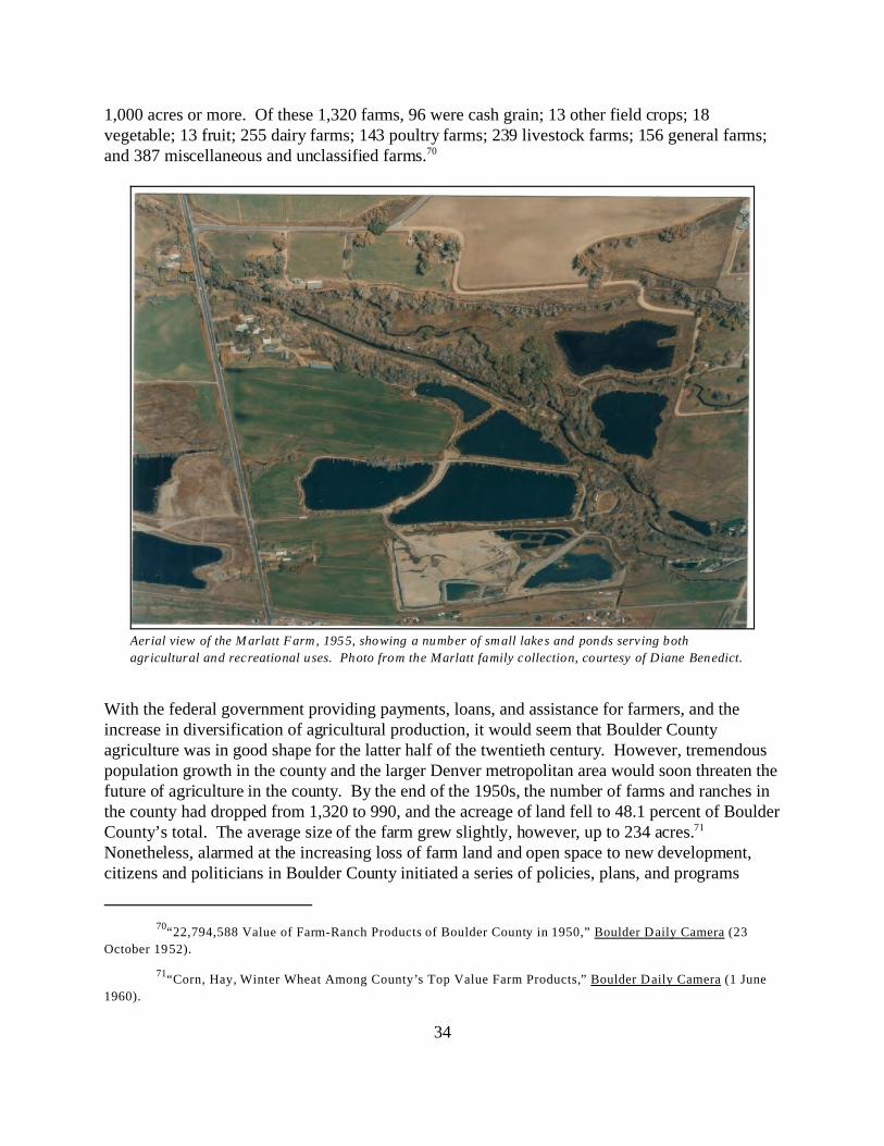
70“22,794,588 Value of Farm-Ranch Products of Boulder County in 1950,” Boulder Daily Camera (23
October 1952).
71“Corn, Hay, Winter Wheat Among County’s Top Value Farm Products,” Boulder Daily Camera (1 June
1960).
34
Aerial view of the M arlatt Farm, 1955, showing a number of small lakes and ponds serving both
agricultural and recreational uses. Photo from the Marlatt family collection, courtesy of Diane Benedict.
1,000 acres or more. Of these 1,320 farms, 96 were cash grain; 13 other field crops; 18vegetable; 13 fruit; 255 dairy farms; 143 poultry farms; 239 livestock farms; 156 general farms;and 387 miscellaneous and unclassified farms.70
With the federal government providing payments, loans, and assistance for farmers, and theincrease in diversification of agricultural production, it would seem that Boulder Countyagriculture was in good shape for the latter half of the twentieth century. However, tremendouspopulation growth in the county and the larger Denver metropolitan area would soon threaten thefuture of agriculture in the county. By the end of the 1950s, the number of farms and ranches inthe county had dropped from 1,320 to 990, and the acreage of land fell to 48.1 percent of BoulderCounty’s total. The average size of the farm grew slightly, however, up to 234 acres.71 Nonetheless, alarmed at the increasing loss of farm land and open space to new development,citizens and politicians in Boulder County initiated a series of policies, plans, and programs

35
which aimed to halt, or at least slow the loss of open space. Beginning in 1960 with the reportPreserving Open Space prepared by Trafton Bean & Associates for the Boulder County RegionalPlanning Commission, the county began taking a hard look at the growth and developmentchanges that were taking place in the county. In 1967, the Boulder County Commissionersappointed the first Parks and Open Space Advisory Committee (POSAC), and the City ofBoulder started their Open Space program. The next year, POSAC recommended theestablishment of a Parks and Open Space District to acquire and preserve parkland, and thecounty began work on the “St. Vrain River” study.
Agricultural lands and farming lifestyles would continue to be threatened throughout theremainder of the twentieth century, but 1967 may be viewed as a turning point in the opinions ofBoulder County citizens. Through the programs established this year, several thousand acres ofagricultural properties in the county would later be protected through the purchase and lease offarm and ranch lands. These purchases have also changed farm and ranching operations inBoulder County, though, as family-owned farms continue to decrease in numbers and leasearrangements or natural resource conservation activities take their place. Nonetheless, farmersand ranchers are no longer the only segment of the population worried about the future ofagriculture in Boulder County; it remains a matter of concern for all citizens.
36
HISTORIC AGRICULTURAL PROPERTY TYPES
The following property types include buildings, structures, objects, sites or districts associatedwith agricultural activities that occurred in unincorporated Boulder County from 1859 through1967. The property types are primarily based on historic function of individual resource,although the first property type, “Farms, Ranches, Agricultural Districts and Rural CulturalLandscapes,” is comprised of numerous resources which may have varied functions. Whenevaluating agricultural resources in Boulder County, it is important first to look at farms andranches as integrated agricultural complexes. The individual resources may have historically hadvery specific and limited functions, but all of buildings and structures worked together as a“whole” to produce the agricultural products of the complex.
This all-encompassing property type is followed by property types defining specific buildings,structures, or landscape features classified by the historic use of the resource, even if that use haschanged throughout the years. In some instances, there are very few extant representatives ofthese property types left in the county. Just as Boulder County’s economy has always beendiversified, from the initial emphasis on mining through the development of the state universityand up to its present prominence in scientific research and high-tech industry, historicagricultural activities in Boulder County have also been diversified. Unlike some other Coloradocounties, no one type of agriculture dominated throughout the entire historic period. Forexample, even though the county experienced a brief period of open cattle ranges, this later evolved into the use of feedlots as well as mountain pastures for fattening. In addition to cattle,sheep, hogs, breeding stock, and poultry were raised in Boulder County. Grain crops such aswheat and oats, as well as hay, fruits, market produce, and dairy products also played a part inBoulder County’s agricultural heritage. This variety, coupled with subsequent residential growthand destruction of agricultural land, has unfortunately led to few remaining examples of some ofthese various types of agricultural activities in the county.
37
Farms, Ranches, Agricultural Districts and Rural Cultural Landscapes
A farm or ranch includes a grouping of individual buildings, structures, and objects, as well asassociated cultural landscape features including roads, drives, trees, and fences. If enoughfeatures are present (generally more than three contributing resources), the farms or ranches maybe considered agricultural districts. Rural cultural landscapes might consist of a single large farmor ranch, but more typically contain several farms set within a larger rural context.
As noted, historically farms or ranches featured a number of individual buildings, structures,objects, and associated cultural landscape features. This grouping generally sited the buildingsfar enough apart to avoid objectionable odors in the house, reduce fire risk, and improve sanitaryconditions. However, they were located closely enough to reduce the required labor to aminimum. Most farms arranged the outbuildings somewhat to the rear of the house and/or to oneside. The main residence was generally the most prominent building within the group, followedby the main barn. The farm or ranch house was generally visible from and oriented to the publicroad, with a lawn in front. The main house was set back some distance in order to avoid dustfrom the road.
As noted, historically farms or ranches featured a number of individual buildings, structures,objects, and associated cultural landscape features. This grouping generally located the buildingsfar enough apart to prevent objectionable odors from reaching the house, reduce fire risk amongbuildings, and improve sanitary conditions. However, they were situated closely enough toreduce labor to a minimum. Most farms arranged the outbuildings to the rear of the house and/orto one side. The main residence was generally the most prominent building within the group,followed by the main barn. The farm or ranch house was typically visible from and oriented tothe public road with a lawn in front. These houses were set back some distance in order to avoiddust from the road. Mountain farms, however, were arranged as the topography would allow,which sometimes caused buildings to be situated more closely than would typically be desired.
The grouping of outbuildings on a farm or ranch was optimally planned in such a manner that allcould be entered without passing through gates. Any feed lots were located to the rear of thebarns and away from the house. Other outbuildings were often grouped according to their uses. The tool shed, machine shelter, and garage shared similar uses and were therefore situated neareach other. Grain and hay storage were most likely adjacent to the animal enclosures and shelterfor convenience in feeding. Larger stock barns were set to form a protection for a shelteredenclosure, and if possible, were located in the direction away from the prevailing summer winds. Hog barns in particular were located the greatest distance from the house, but still near cribs forfeeding. Privies or outhouses were also separated from the main house away from prevailingwinds to protect against odor, yet were still close enough for convenience. Poultry houses werelocated nearer to the main house than most other outbuildings, since most farm wives dutiesincluded care of the chickens; this also provided quick access for fresh eggs and meat for meals. Most generally faced south to take advantage of solar gain for warming the building.

38
Scates Ranch on upper Magnolia.
Windbreaks to the north and west of the buildings were also typical features, although many ofthese may today be nearing the end of their natural life. Fruit trees and shade trees may also bepresent, in addition to flowering plants and shrubs. Family gardens were located near the house. In addition to a lawn, a show pasture or field may be located in front of the main residence or tothe side of the farm, in order to display the best animals and prove a clean, permanent pasturevisible from the house. Mountain pastures or fields may be marked by piles of stones or evenstone walls to one side or the edge, and serve as evidence of fields having been cleared foragricultural use.
A historic farm or ranch may haveencompassed eighty acres, or even severalhundred or thousands of acres, and someindividual buildings and structures mayhave been isolated. Development andgrowth in Boulder County, particularlyafter World War II, have severelyimpacted the size and nature ofagricultural operations. Many propertieshave since been redeveloped, resulting inthe loss of fields, pastures, orchards and“unimproved” farm land. In manyinstances, only a small proportion of thefarm or ranch remains. However, this isoften the most intensely developed sectionthat contained the majority of buildingsand structures. Other isolated agriculturallandscapes give the appearance of beingundeveloped, with only stock tanks,fences and cattle guards to provide evidence that the land had agricultural associations. Althoughthis land may have a natural appearance, virtually none is in a natural state. Grazing or otheragricultural activities for over a century have altered the landscape in fundamental ways;therefore, many of these fields or pastures may be classified as rural historic or culturallandscapes. A rural cultural landscape is a geographic area (including both cultural and naturalresources and the wildlife or domestic animals therein) that is associated with a historic event,activity, or person or exhibiting other cultural or aesthetic values. There are four general types ofcultural landscapes, not mutually exclusive; the one that is more typically associated with ruralhistoric districts and agricultural landscapes in Boulder County is a historic vernacularlandscape, which is a landscape that evolved through use by the people whose activities oroccupancy shaped it. Through social or cultural attitudes of an individual, a family, or acommunity, the landscape reflects the physical, biological, and cultural character of everydaylives. In this instance, an agricultural function played a significant role in vernacular landscapes. An agricultural cultural landscape may be significant as the site of an important event or activity,reflect cultural traditions, or other patterns of settlement or land use.

72Virginia & Lee M cAlester, A Field Guide to American Houses (New York: Alfred A. Knopf, 1984) 89.
39
Walker Ranch log house, with squared log construction.
Photo by Carol Beam, Boulder County Parks & Open Space
Department (BCPOS).
Farm house, ranch house, or worker housing
A farm or ranch house typically served asthe primary residence of the owner oroperator, although smaller residences mayalso have been present for hired hands. The primary residence not only served asthe family house, it also typically servedas the business office. These dualfunctions made it the focal point of thefarm or ranch. These houses were oftenthe most substantial building on theproperty in terms of size, workmanship,and style, although the early settlementdugouts, sod houses, or log cabins werequite crude. Migrant or worker housingwere simple buildings that wereconstructed with a minimum of expenseand time.
A wide variety of forms and stylescharacterize the main houses, most ofwhich generally reflect the popular orvernacular trends of the period in whichthey were constructed. Those constructedin the late nineteenth and the first decadeof the twentieth century were generallyexamples of National Folk forms.72 These often employed local materials andsimple workmanship, with occasionaldetails or architectural influences from thelate Victorian styles. An example of a“gable-front-and-wing” house is the one-and-a-half story wood frame, clapboardfarm house located at 3285 N. 95th Street. A few examples are relatively ostentatiousdisplays of wealth. Farm or ranch housesbuilt in the early to mid-twentieth century were typical of those constructed from plan or patternbooks, and were examples of American movements, such as the Craftsman or Prairie styles, orrevival styles, such as variants of the Dutch or Colonial revival.
A gable-front-and-wing farm house with Late Victorian details
at 3285 N. 95 th Street.
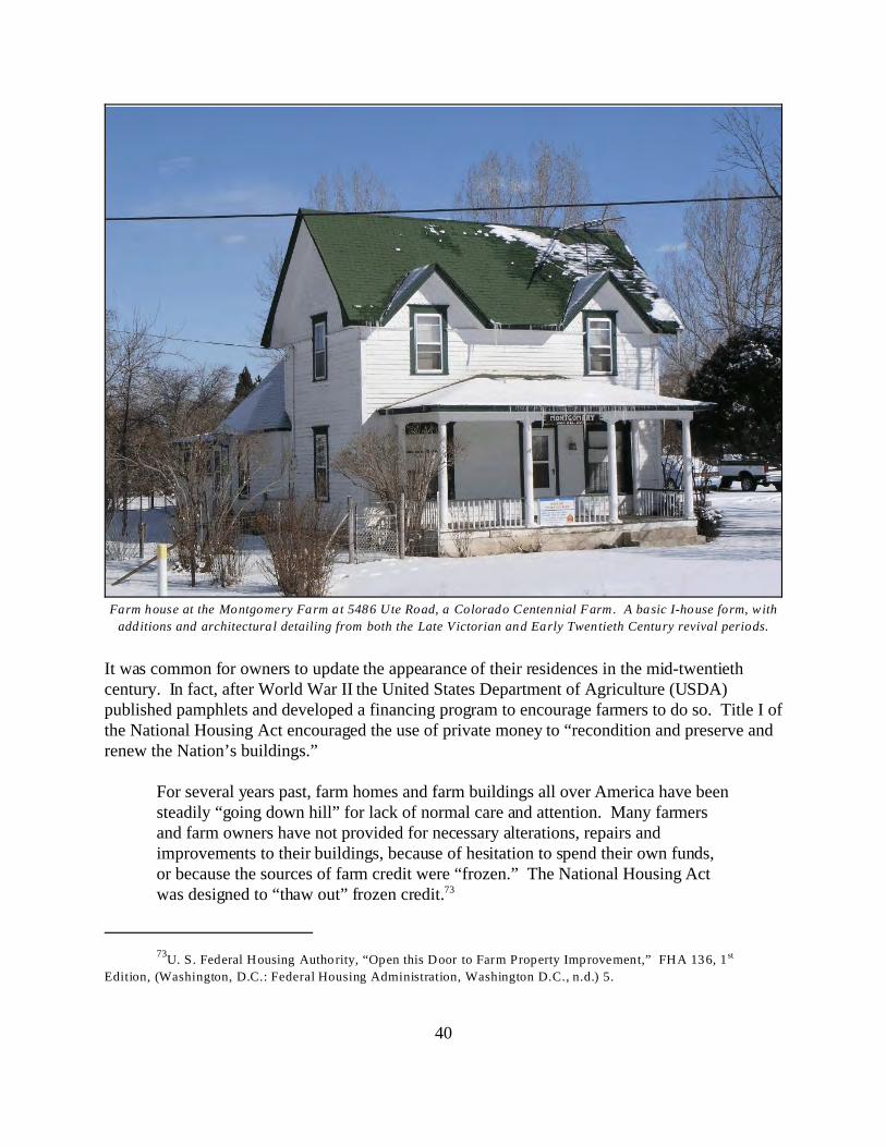
73U. S. Federal Housing Authority, “Open this Door to Farm Property Improvement,” FHA 136, 1 st
Edition, (Washington, D.C.: Federal Housing Administration, Washington D.C., n.d.) 5.
40
Farm house at the Montgomery Farm at 5486 Ute Road, a Colorado Centennial Farm. A basic I-house form, with
additions and architectural detailing from both the Late Victorian and Early Twentieth Century revival periods.
It was common for owners to update the appearance of their residences in the mid-twentiethcentury. In fact, after World War II the United States Department of Agriculture (USDA)published pamphlets and developed a financing program to encourage farmers to do so. Title I ofthe National Housing Act encouraged the use of private money to “recondition and preserve andrenew the Nation’s buildings.”
For several years past, farm homes and farm buildings all over America have beensteadily “going down hill” for lack of normal care and attention. Many farmersand farm owners have not provided for necessary alterations, repairs andimprovements to their buildings, because of hesitation to spend their own funds,or because the sources of farm credit were “frozen.” The National Housing Actwas designed to “thaw out” frozen credit.73
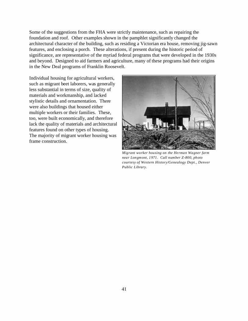
41
Migrant worker housing on the Herman Wagner farm
near Longmont, 1971 . Call number Z-800, photo
courtesy of Western History/Genealogy Dept., Denver
Public Library.
Some of the suggestions from the FHA were strictly maintenance, such as repairing thefoundation and roof. Other examples shown in the pamphlet significantly changed thearchitectural character of the building, such as residing a Victorian era house, removing jig-sawnfeatures, and enclosing a porch. These alterations, if present during the historic period ofsignificance, are representative of the myriad federal programs that were developed in the 1930sand beyond. Designed to aid farmers and agriculture, many of these programs had their originsin the New Deal programs of Franklin Roosevelt. Individual housing for agricultural workers,such as migrant beet laborers, was generallyless substantial in terms of size, quality ofmaterials and workmanship, and lackedstylistic details and ornamentation. Therewere also buildings that housed eithermultiple workers or their families. These,too, were built economically, and thereforelack the quality of materials and architecturalfeatures found on other types of housing. The majority of migrant worker housing wasframe construction.

74The term crib can be confusing because it is applied to agricultural buildings in two ways. Here it refers
to a pen composed of logs that is used for crop, equipment storage or animal shelter. It is also used for a more
specialized structure used to store corn (see page 23).
42
General purpose barn at Monteau Geer farm. View of the
lower stable level. Photo by Carol Beam, BCPOS.
Barns and secondary outbuildings
A working farm or ranch required a number of auxiliary buildings and structures, such as barns,corrals, and sheds. These buildings provided shelter for livestock, storage space for equipment,and machinery, and specialized structures for the management of feeding of livestock. Few ofthese buildings or structures were likely to exhibit elements of style, or even necessarily ofquality workmanship or materials. They were typically buildings of simple materials with aminimum of decoration, with utility or function clearly dictating the form. Some, particularlythose built in the late nineteenth century, may show local vernacular characteristics, such as useof local materials and methods of construction. These resources tended to be concentratedaround the main house so that owner or operator could maintain control over the primaryagricultural operations with a minimum of effort. Examples of subtypes of this property typeinclude barns, both general purpose and dairy, animal structures (hog and poultry houses),implement and machine sheds, garages, storm cellars, privies, and wood or coal sheds.
General purpose barns are sometimes thelargest building and most prominentbuilding on an agricultural property. Theymay be classified by form, roof shape,number of stories, and size, all of whichreflect their historic purpose; some areclassified by their location andconstruction method, such as bank barns;others reflect the ethnic heritage of theirowners. Most have concrete or stonefoundations, and are frame constructionwith horizontal or vertical wood siding. The roofs, most commonly gable orgambrel, are steeply pitched in order toprovide storage for hay in the upper loft. Consequently, many barns also have gable end hayhoods and doors on the upper levels. The majority of extant barns in Boulder County arerectangular and feature a central passage with sliding or swinging doors.
Alan Noble has summarized past studies of historic barns in his book Wood, Brick and Stone:The North American Settlement Landscape, Volume 2: Barns and Farms Structures (1984). While most of the studies have been focused on the eastern portion of the United States, thisbook nonetheless provides a background for understanding the evolution of barns and method forcategorizing basic barn forms. The simplest and often earliest barns were single-crib barns.74

43
The Henning Farm barn – a M idwest three-portal barn
formed by shed additions to the side.
Photo by Carol Beam, BCPOS.
Hall Ranch bank barn. Photo by Carol Beam, BCPOS.
Lean-to sheds were often added to eitherside in order to expand the usefulness of thebarn. Double crib and drive-in crib barns werelater evolutions, and featured a centralpassage. A four-crib barn has cross aislesor passages, with doors on all four sides. This later evolved into a transverse-framebarn, which saw the side aisle openingsboarded over and frame cribs constructedon the sides between the four corner cribs. The gable to gable aisle remained open forpassage. A Midwest three-portal barn is atransverse-frame barn with the addition of arow of cribs on either side, as well as twomore interior aisles. Some of these barnswere planned with three aisles from theoutset, while others were originallytransverse-frame barns with later shed-roofadditions on either side.
Additional barn classifications are based onthe ethnic origins of their plan. An Englishbarn, for example, is a small rectangularbarn with a central floor runway flanked bytwo roughly equal sized spaces on eitherside, with a loft above for hay. The passagedoors are on the side, rather than the gableends. Originally brought to New England,it moved westward to the grasslands withrelatively little change. Bank barns wereintroduced by the Germans inPennsylvania. The design of a bank barnallowed it to combine the functions of cropstorage, threshing, and animal shelter intoone building. The barn was built with itslong side parallel and into the side of a hill,providing entry on two different levels. The lower level housed animals, while the upper levelsserved for threshing and storage. The upper hillside entrance was used by wheat or hay wagons,and fodder could be dropped through openings in the floor to the stable below. Where a hill waslacking, a "bank" was created by building up an earthen ramp to the second level.
Barns were also sometimes categorized by their use, particularly if it was specialized. Dairybarns, for example, usually required greater care in design and construction than most other farm

44
Chicken house on the Barrett Farm.
Photo by Carol Beam, BCPOS.
Harney Lastoka loafing shed.
Photo by Carol Beam, BSPOS.
outbuildings. The location and size of stalls, mangers, gutters, alleys, pens and milk rooms allposed specific design requirements, yet also had to be individualized for the size of the owner’soperations. After about 1910, hollow concrete tiles were popular construction materials for dairybarns due to the ease of sanitizing the material. For the same reason, most dairy barn floors wereconcrete.
In addition to general purpose barns, there maybe several other outbuildings that served tohouse and protect livestock. Hog houses,chicken coops or poultry houses, feedingbarns, and loafing sheds are examples of thissubtype. Hog houses could be moveable orcommunity, and are generally rare in BoulderCounty. Poultry houses can also be dividedinto two categories – the colony (small) orcommunity (permanent) house. Colonyhouses are usually built on sill, which serve asrunners to the house can be moved. Theytypically have shed or gable roofs. Community poultry houses may have shed,gable, combination, or half-monitor roofs. The buildings generally face south, and aremost typically simple wood frame buildings.
Loafing sheds are long, rectangular structureswith siding on three elevations, to providesome protection from the elements, and a longopening on one elevation to provide access forshelter and feed. They have shed roofs, woodpost supports, and vertical wood siding. Theygenerally are set at one end of a corral orfenced lot.
Implement and machine sheds were necessarystorage facilities because equipment neededcare and housing. This was particularly true inthe twentieth century when machinery became larger and more expensive. If left constantlyexposed to the weather, the equipment lost value rapidly. According to a USDA report in 1922,the annual loss in depreciation of farm equipment due to lack of shelter was more than 100million dollars. A cheaply built shelter was estimated to increase the life of farm implements byfive years or more – a savings that paid for the cost of the shelter in a short time. These buildingswere designed to afford protection and convenience in storage and provide plenty of space. Therefore, most were tightly enclosed on all sides as well as the roof. If a wide opening was
75Ibid.
45
necessary, continuous doors along one side were preferable to an open shed building, whichalthough cheaper to construct did not provide as much protection. Windows were included toprovide light by which to work. Prior to the 1920s, ten feet was generally the maximum heightthat was required to meet the needs of most farm machinery; later, larger metal ready-madebuildings were developed to house the increased size of machinery after World War II. Woodframe construction was typical prior to WWII, with some buildings featuring hollow clay tile orconcrete wall construction. Roofs were either shed, gable, gambrel, or a combination.
Garages associated with agricultural properties in Boulder County are generally simple,rectangular buildings with gable roofs, wood siding, and (originally) wood doors. They arelocated near the main residence off of the drive leading from the road. Storm cellars weredesigned for protection from severe weather, and were often mounded up from level ground. InBoulder County, it is likely that these were incorporated into root and fruit cellars, serving dualpurposes. Privies or outhouses were once common features on farms and ranches, and are stillfound in relatively high numbers in unincorporated Boulder County.75 Most were small, woodframe with a shed roof. These were located away from the house to protect the latter from theodor, yet were still close enough for convenience.
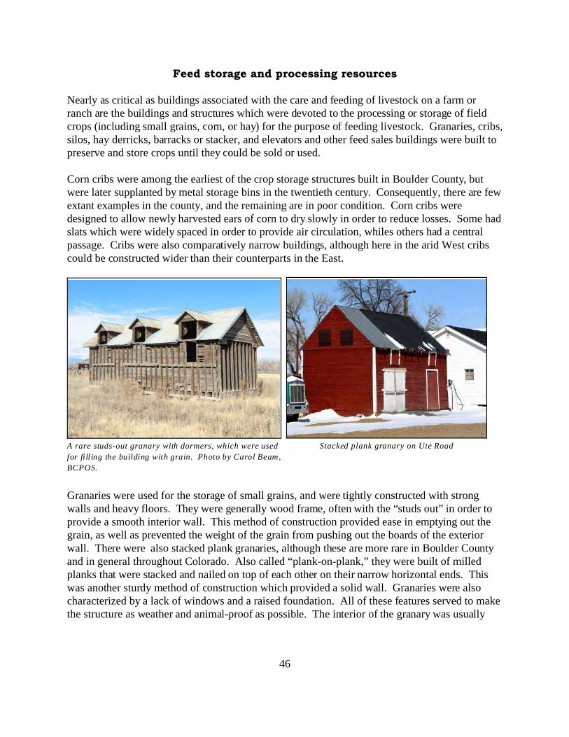
46
Stacked plank granary on Ute RoadA rare studs-out granary with dormers, which were used
for filling the building with grain. Photo by Carol Beam,
BCPOS.
Feed storage and processing resources
Nearly as critical as buildings associated with the care and feeding of livestock on a farm orranch are the buildings and structures which were devoted to the processing or storage of fieldcrops (including small grains, corn, or hay) for the purpose of feeding livestock. Granaries, cribs,silos, hay derricks, barracks or stacker, and elevators and other feed sales buildings were built to preserve and store crops until they could be sold or used.
Corn cribs were among the earliest of the crop storage structures built in Boulder County, butwere later supplanted by metal storage bins in the twentieth century. Consequently, there are fewextant examples in the county, and the remaining are in poor condition. Corn cribs weredesigned to allow newly harvested ears of corn to dry slowly in order to reduce losses. Some hadslats which were widely spaced in order to provide air circulation, whiles others had a centralpassage. Cribs were also comparatively narrow buildings, although here in the arid West cribscould be constructed wider than their counterparts in the East.
Granaries were used for the storage of small grains, and were tightly constructed with strongwalls and heavy floors. They were generally wood frame, often with the “studs out” in order toprovide a smooth interior wall. This method of construction provided ease in emptying out thegrain, as well as prevented the weight of the grain from pushing out the boards of the exteriorwall. There were also stacked plank granaries, although these are more rare in Boulder Countyand in general throughout Colorado. Also called “plank-on-plank,” they were built of milledplanks that were stacked and nailed on top of each other on their narrow horizontal ends. Thiswas another sturdy method of construction which provided a solid wall. Granaries were alsocharacterized by a lack of windows and a raised foundation. All of these features served to makethe structure as weather and animal-proof as possible. The interior of the granary was usually
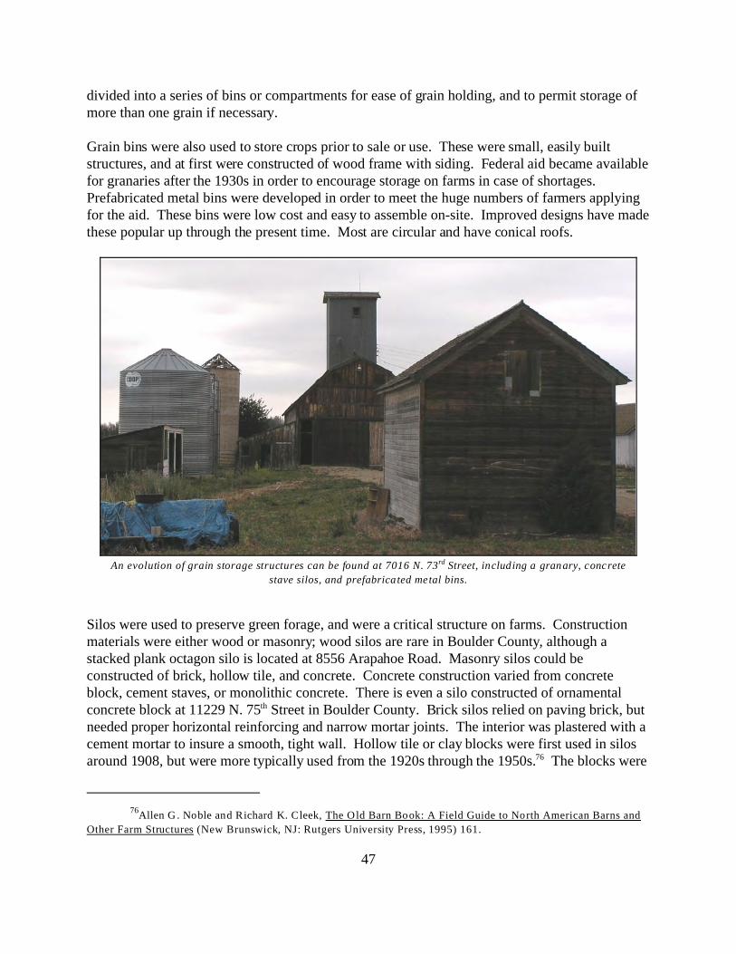
76Allen G . Noble and Richard K. Cleek, The Old Barn Book: A Field Guide to North American Barns and
Other Farm Structures (New Brunswick, NJ: Rutgers University Press, 1995) 161.
47
divided into a series of bins or compartments for ease of grain holding, and to permit storage ofmore than one grain if necessary.
Grain bins were also used to store crops prior to sale or use. These were small, easily builtstructures, and at first were constructed of wood frame with siding. Federal aid became availablefor granaries after the 1930s in order to encourage storage on farms in case of shortages. Prefabricated metal bins were developed in order to meet the huge numbers of farmers applyingfor the aid. These bins were low cost and easy to assemble on-site. Improved designs have madethese popular up through the present time. Most are circular and have conical roofs.
Silos were used to preserve green forage, and were a critical structure on farms. Constructionmaterials were either wood or masonry; wood silos are rare in Boulder County, although astacked plank octagon silo is located at 8556 Arapahoe Road. Masonry silos could beconstructed of brick, hollow tile, and concrete. Concrete construction varied from concreteblock, cement staves, or monolithic concrete. There is even a silo constructed of ornamentalconcrete block at 11229 N. 75th Street in Boulder County. Brick silos relied on paving brick, butneeded proper horizontal reinforcing and narrow mortar joints. The interior was plastered with acement mortar to insure a smooth, tight wall. Hollow tile or clay blocks were first used in silosaround 1908, but were more typically used from the 1920s through the 1950s.76 The blocks were
An evolution of grain storage structures can be found at 7016 N. 73rd Street, including a granary, concrete
stave silos, and prefabricated metal bins.

77Ibid.
48
Concrete stave silo adjacent to barn at Lohr/
McIntosh Farm
Hollow glazed clay tile silo
between 4-6" thick. Some blocks were grooved to receive reinforcing, and were curved to theform of the silo wall. Reinforcing was steel wire embedded in mortar joints. Reinforcingconcrete jambs were also used, and were tied across at intervals to prevent spreading. A variety
of patented blocks were used for concrete block silos; some were curved. Reinforcing was eitherembedded in the block or placed in the mortar joint. Stucco was sometimes applied to theexterior surface for appearances and to fill up the pores, while a cement wash was applied to theinterior. Cement-stave silos first appeared around 1906.77 There were various patented stavesthat differed, among other things, in their end joints. The staves were bound with steel hoops andrequired special door spreaders. Their interiors were also given a cement wash. Monolithic silosare solid concrete and were constructed with standard forms on-site. The reinforcing wasembedded in the wall. Doors for silos were individual or continuous. Chutes were used to coverthe doors, and allow silage to be thrown down without trouble from the wind. Based on fieldobservation, roofs were rare in Boulder County silos. The few extant roofs are low conical andround gambrel. Instead of roofs, many silos in the county had wire extensions on the top to allowfor settling after the initial loading. Most silos are located immediately adjacent to barns forconvenience, but a few are located in feed lots. Trench or pit (below ground) silos were dug intothe ground, and were geared to grass ensilage. Bunker silos were built after World War II.

78Ibid.
49
Two Harvestore silos and a cement stave silo,
located west of Nelson Road near Table Mountain.Harney Lastoka pit/trench silo.Photo by Carol Beam, BCPOS.
Similar to trench silos, concrete bunker silos were built above ground and featured three wallswith an open top. The open end was designed for easy access by mechanical harvesters of grassensilage, and sometimes for self-feeding of the livestock. The top was sealed when necessary byplastic sheets held in place, often with old tires. Harvestore silos are rare in Boulder County dueto their original costs, although a few still remain. They were used for large herds of dairy cows. These easily recognized blue silos were invented by the A.O. Smith Company of Wisconsin afterWorld War II, and are made of fiberglass and metal panels. These silos empty automaticallyfrom the bottom.78
Hay barracks, stackers and derricks are very rare in Boulder County, although a few have beenidentified in previous surveys. Hay barracks were used for storage, and were simply four poleswith a roof above. Hay derricks and stackers were also of wood pole construction, but were usedto stack hay in a manner to reduce spoilage. Baskets or racks on stackers were sometimes atangles, and cables and pulleys raised the hay basket.
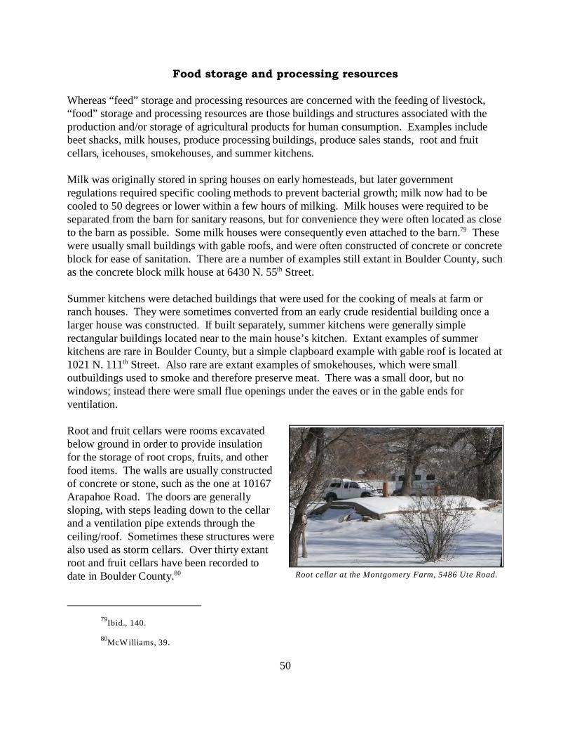
79Ibid., 140.
80McW illiams, 39.
50
Root cellar at the Montgomery Farm, 5486 Ute Road.
Food storage and processing resources
Whereas “feed” storage and processing resources are concerned with the feeding of livestock,“food” storage and processing resources are those buildings and structures associated with theproduction and/or storage of agricultural products for human consumption. Examples includebeet shacks, milk houses, produce processing buildings, produce sales stands, root and fruitcellars, icehouses, smokehouses, and summer kitchens.
Milk was originally stored in spring houses on early homesteads, but later governmentregulations required specific cooling methods to prevent bacterial growth; milk now had to becooled to 50 degrees or lower within a few hours of milking. Milk houses were required to beseparated from the barn for sanitary reasons, but for convenience they were often located as closeto the barn as possible. Some milk houses were consequently even attached to the barn.79 Thesewere usually small buildings with gable roofs, and were often constructed of concrete or concreteblock for ease of sanitation. There are a number of examples still extant in Boulder County, suchas the concrete block milk house at 6430 N. 55th Street.
Summer kitchens were detached buildings that were used for the cooking of meals at farm orranch houses. They were sometimes converted from an early crude residential building once alarger house was constructed. If built separately, summer kitchens were generally simplerectangular buildings located near to the main house’s kitchen. Extant examples of summerkitchens are rare in Boulder County, but a simple clapboard example with gable roof is located at1021 N. 111th Street. Also rare are extant examples of smokehouses, which were smalloutbuildings used to smoke and therefore preserve meat. There was a small door, but nowindows; instead there were small flue openings under the eaves or in the gable ends forventilation.
Root and fruit cellars were rooms excavatedbelow ground in order to provide insulationfor the storage of root crops, fruits, and otherfood items. The walls are usually constructedof concrete or stone, such as the one at 10167Arapahoe Road. The doors are generallysloping, with steps leading down to the cellarand a ventilation pipe extends through theceiling/roof. Sometimes these structures werealso used as storm cellars. Over thirty extantroot and fruit cellars have been recorded todate in Boulder County.80

51
Ice houses, although technically used for frozen water storage, are categorized with this sub-typedue to their associative function with food storage. Ice houses were barn-like wood structures,generally unpainted, with smooth interior wood wall construction (like granaries) in order tomaximize storage space. They often had a large, full-height door. As the ice was cut from pondsand stacked inside, the lower portion of the door was closed down with boards. There are lessthan ten extant examples remaining in the county.

52
Watering facilities, windmills, and irrigation resources
Watering facilities include those structures and sites wherewater is taken from the ground for storage and use bylivestock or people. At natural springs, water comes to thesurface without the aid of pumps. In the early settlementof Boulder County, the location of springs oftendetermined the location of farms and ranches. It was notunusual to make improvements around a spring in order tominimize water loss and protect the water quality, such asa spring house, or to transfer water to tanks or concretechannels. A well is a dug or drilled hole where water isdrawn up from the ground for use. Most wells have somesort of pump to draw up the water. Originally hand pumpsor windmills, these were sometimes changed to electric orgas-powered pumps in the twentieth century. Windmillsare common devices for pumping water out of the ground,especially in isolated areas. They are structures with largefan blades that are turned by the wind. This rotationalenergy is transmitted through gears and shafts to the pumpthat in turn draws up the water. Ponds in Boulder Countywere usually man-made for storage purposes.
Spring houses were small buildingsdesigned to protect the spring watersource, as well as to provide a coolstorage space for perishable farmproducts. Constructed of masonry (atleast the foundation), they weresometimes also built into slopes in orderto provide additional insulation. Externalwater openings to channel water to otherareas of the farm are often evident. Wellhouses are structures built over a well toprotect it from the elements; theysometimes also function as a storageshed. Water tanks are structures that holdwater drawn from wells to make itavailable for livestock to drink. Thesetanks may be constructed of concrete,
Windmill at the Lohr/McIntosh Farm.
Photo by Carol Beam, BCPOS.
Concrete block springhouse built into the hillside at Scates
Ranch, with a pipe leading to a stock tank.

53
metal, wood, or other materials. A stock tank is generally much larger, and gets its water fromsources other than a well.
An irrigation system may have several components, including dams, headgates, drop structures,division boxes, pumphouses, ditches, canals, laterals, pipelines, ponds or reservoirs. Anirrigation system is used to distribute water to fields, pastures, and orchards. A ditch or canal isan open, built waterway for carrying water from a water source. Pipelines are another system formoving water from a source to a tank or field. Many Boulder County agricultural operationsdeveloped extensive irrigation systems in order to support their crops and livestock. Theseresources represent the heritage of water use in the West, which has evolved into a complexsystem of water rights involving not only agriculture and private individuals, but the ditchcompanies, industry, and federal, state, and local governments as well.
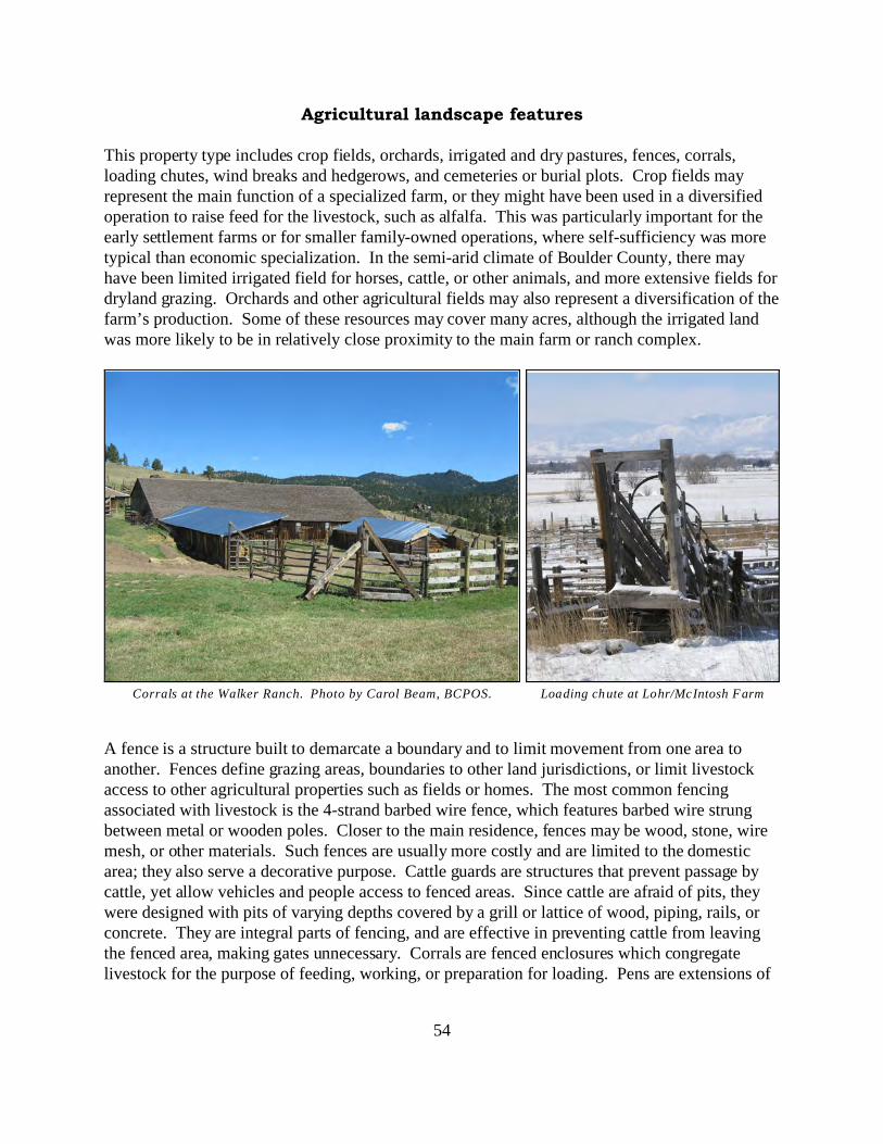
54
Loading chute at Lohr/McIntosh FarmCorrals at the Walker Ranch. Photo by Carol Beam, BCPOS.
Agricultural landscape features
This property type includes crop fields, orchards, irrigated and dry pastures, fences, corrals,loading chutes, wind breaks and hedgerows, and cemeteries or burial plots. Crop fields mayrepresent the main function of a specialized farm, or they might have been used in a diversifiedoperation to raise feed for the livestock, such as alfalfa. This was particularly important for theearly settlement farms or for smaller family-owned operations, where self-sufficiency was moretypical than economic specialization. In the semi-arid climate of Boulder County, there mayhave been limited irrigated field for horses, cattle, or other animals, and more extensive fields fordryland grazing. Orchards and other agricultural fields may also represent a diversification of thefarm’s production. Some of these resources may cover many acres, although the irrigated landwas more likely to be in relatively close proximity to the main farm or ranch complex.
A fence is a structure built to demarcate a boundary and to limit movement from one area toanother. Fences define grazing areas, boundaries to other land jurisdictions, or limit livestockaccess to other agricultural properties such as fields or homes. The most common fencingassociated with livestock is the 4-strand barbed wire fence, which features barbed wire strungbetween metal or wooden poles. Closer to the main residence, fences may be wood, stone, wiremesh, or other materials. Such fences are usually more costly and are limited to the domesticarea; they also serve a decorative purpose. Cattle guards are structures that prevent passage bycattle, yet allow vehicles and people access to fenced areas. Since cattle are afraid of pits, theywere designed with pits of varying depths covered by a grill or lattice of wood, piping, rails, orconcrete. They are integral parts of fencing, and are effective in preventing cattle from leavingthe fenced area, making gates unnecessary. Corrals are fenced enclosures which congregatelivestock for the purpose of feeding, working, or preparation for loading. Pens are extensions of

55
corrals which allow the rancher to perform duties such as routine health functions. Holding pensare used to keep cattle contained while waiting for other functions. A subcategory of a holdingpen is a crowding area, which is a specialized pen used to funnel cattle into loading chutes. Loading chutes are ramped structures which are used to load cattle, one at a time, into a truck orrail car. They are narrow and have a ramp and enclosed sides (historically fenced).
Other landscape features of a farm or ranch in Boulder County may include crop fields, pastures,and orchards. Most crop land was irrigated; pasture land was also sometimes irrigated in order tosupplement the natural grass ranges. Crop fields may be small, typically representing adiversification of the farm’s output, or large for specialized production. Dryland range orpastures were large areas, with fencing generally representative of ownership boundaries. Fieldsin the plains were usually rectangular or square, while those located in the mountains of BoulderCounty were often irregular in shape, conforming to the steeper topography and rockoutcroppings. These fields may also have stone piles or fences on one side as evidence ofclearing for agricultural use. Orchards in Boulder County were comparatively small, with thefruit trees planted in straight rows at set intervals, allowing for ease in mowing and spraying.
Cemeteries, burial grounds or grave sites areother examples of agricultural landscape features. It was not uncommon for rural families to burydeceased on their home property. Especiallyfrom the settlement period, formal cemeteries arerare and are more likely graves, sometimeslacking even markers. These may occur as smallfamily plots located a short distance from themain house, but not as close as gardens.
Although perhaps the broadest category ofproperty types, agricultural landscapes are clearlyamong the most significant. Without the land,the “industry” of agriculture would not exist. Agricultural landscape features are most likely tobe eligible as contributing resources within alarger agricultural district. Without any otherassociated property types, it would be difficult forlandscape features by themselves to convey thehistoric contexts.
Wagon wheels mark the family plot at Scates Ranch.

56
Left Hand Grange in Niwot. Photo by Carol Beam, BCPOS.
Granges and agricultural society buildings
Most granges in Boulder County were simple rectangular buildings constructed specifically tohouse the organization. They were frame or brick construction, and had flat, hip, or gable roofs. A few were located in buildings that were constructed for additional uses, such as the upstairs ofa commercial block building, or were located in former residential buildings. Although theirextant numbers are few, granges and other agricultural societies played a key role in the transitionfrom a simple agrarian society to modern agribusiness. The Patrons of Husbandry, founded inWashington D.C. in December 1867, was a fraternal organization that provided a political voicefor farmers after the Civil War.
57
SUMMARY
Boulder County agriculture has faced many challenges through the years -- from grasshoppers togrowth and drought to development. New challenges are undoubtedly ahead for those historicagricultural properties which remain. In order to preserve some of these properties for the benefitof future generations, it is necessary to evaluate their historic and architectural significance. Aproper evaluation can occur only when they are referenced against broad patterns of the historicalagricultural development within the county. It is hoped that this report presents the importantlinks for Boulder County's agricultural properties to local, state, or even national themes inagricultural history. Only through an understanding of the past can informed planning decisionsbe made for the future of these historic agricultural properties

58
Barn on St. Vrain Road.
APPENDICES

59
Appendix A
Early Ditch Decrees for Division 1, District No. 6. Taken from Anne Dyni, Pioneer Voices ofBoulder County, published by Boulder County Parks & Open Space Department.
Irrigation Ditch Decrees, District No.6, Boulder Creek
Name of Ditch Date of FeeAppropriation
Lower Boulder Ditch Oct. 1, 1859
Smith & Goss Ditch Nov. 15,1859
Howel Ditch Dec. 1, 1859
Anderson Ditch Oct. 1, 1860
Godding, Dailey, Plumb Mar. 1, 1861
Houck #2 Ditch Apr. 1, 1861
Martha H.Mathews Ditch June 1,1861
N.K.Smith & Tyler Ditch (Reduced by decree)
June 1,1861May 16,1913
Plumb Ditch Apr. 1, 1862
David H. Nichol Ditch
Dry Creek Ditch June 1,1862
M.G. Smith June 1,1862
G. Berkley Ditch June 1,1862
Wellman, Nichols, Hahn June 1,1862
Harden Ditch, heirs of Eliz.Harden & S.Wellman June 1,1862
McCarty Ditch June 1,1862
William Breach Ditch June 1,1862
North Boulder Farmers Ditch June 1,1862
Rural Ditch May 10,1862
Green Ditch Sep. 15,1862

60
Farmers Ditch Oct. 1, 1862
Rural Ditch 1st enlg. Mar. 10,1863
Houck #1 Ditch (Reduced by decree)
Apr. 1, 1863Dec. 8, 1910
Smith & Emmons Ditch June 1,1863
North Boulder Farmers Ditch: 1st enlg June 1,1863
Carr & Tyler Ditch June 1,1864
North Boulder Farmers Ditch, 2nd Enlg. June 1, 1864
Butte Mill Ditch Mar. 1, 1865
Howell & Beasley Ditch Mar. 1, 1865
Delehant Ditch May 1, 1865
Godding, Dailey & Plumb 1st Enlg. Apr. 1, 1865
Highland Ditch South side June 1, 1865
Leggett Ditch May 1, 1868
Highland Ditch South side, 1st Enlg. June 1, 1868
Taylor Ditch Apr. 1, 1870
Lower Boulder,1st Enlg June 1, 1870
Idaho Ditch (Idaho Creek) Oct. 30,1870
Como #1 (Fisher Creek) Jan. 2, 1871
Como #2 (Como Creek) Jan. 3, 1871
Como #3 (Como Creek) Jan. 4, 1871
Young Ditch (Rothrock Slough) Apr. 1, 1871
Boulder & Weld County May 1, 1871
Como #4 (North Boulder Creek) Apr. 1, 1873
Boulder & White Rock Nov. 1, 1873
Boulder & Left Hand Ditch Sec. #38 Enlg. Dec. 1, 1873
Town of Boulder Ditch & Reservoir #1 June 17,1875

61
Boulder & Left Hand 1st Enlg. Apr. 1, 1876
Wellman Ditch May 1, 1878
Mathews Ditch Feb. 13,1879
Revolution Ditch Dec. 7, 1881
Silver Lake Ditch Feb. 28,1888
Silver Lake, 1st Enlg. Nov. 1, 1900
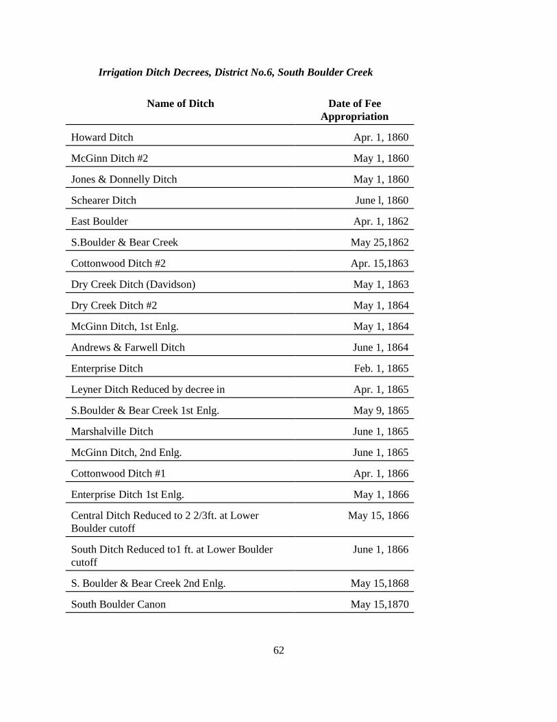
62
Irrigation Ditch Decrees, District No.6, South Boulder Creek
Name of Ditch Date of FeeAppropriation
Howard Ditch Apr. 1, 1860
McGinn Ditch #2 May 1, 1860
Jones & Donnelly Ditch May 1, 1860
Schearer Ditch June l, 1860
East Boulder Apr. 1, 1862
S.Boulder & Bear Creek May 25,1862
Cottonwood Ditch #2 Apr. 15,1863
Dry Creek Ditch (Davidson) May 1, 1863
Dry Creek Ditch #2 May 1, 1864
McGinn Ditch, 1st Enlg. May 1, 1864
Andrews & Farwell Ditch June 1, 1864
Enterprise Ditch Feb. 1, 1865
Leyner Ditch Reduced by decree in Apr. 1, 1865
S.Boulder & Bear Creek 1st Enlg. May 9, 1865
Marshalville Ditch June 1, 1865
McGinn Ditch, 2nd Enlg. June 1, 1865
Cottonwood Ditch #1 Apr. 1, 1866
Enterprise Ditch 1st Enlg. May 1, 1866
Central Ditch Reduced to 2 2/3ft. at LowerBoulder cutoff
May 15, 1866
South Ditch Reduced to1 ft. at Lower Bouldercutoff
June 1, 1866
S. Boulder & Bear Creek 2nd Enlg. May 15,1868
South Boulder Canon May 15,1870
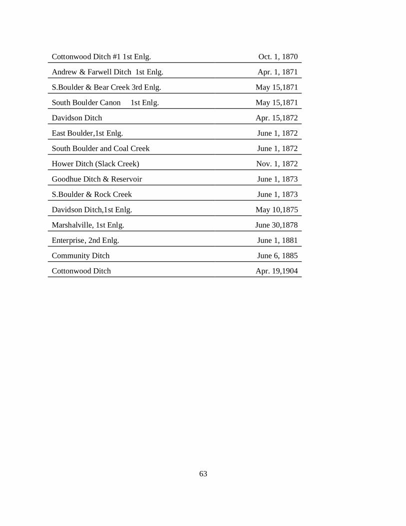
63
Cottonwood Ditch #1 1st Enlg. Oct. 1, 1870
Andrew & Farwell Ditch 1st Enlg. Apr. 1, 1871
S.Boulder & Bear Creek 3rd Enlg. May 15,1871
South Boulder Canon 1st Enlg. May 15,1871
Davidson Ditch Apr. 15,1872
East Boulder,1st Enlg. June 1, 1872
South Boulder and Coal Creek June 1, 1872
Hower Ditch (Slack Creek) Nov. 1, 1872
Goodhue Ditch & Reservoir June 1, 1873
S.Boulder & Rock Creek June 1, 1873
Davidson Ditch,1st Enlg. May 10,1875
Marshalville, 1st Enlg. June 30,1878
Enterprise, 2nd Enlg. June 1, 1881
Community Ditch June 6, 1885
Cottonwood Ditch Apr. 19,1904
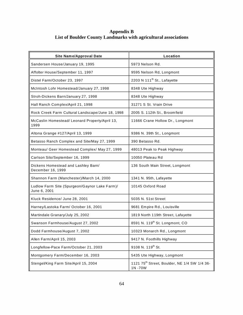
64
Appendix BList of Boulder County Landmarks with agricultural associations
Site Nam e/Approval Date Location
Sandersen House/January 19, 1995 5973 Nelson Rd.
Affolter House/September 11, 1997 9595 Nelson Rd, Longmont
Distel Farm/October 23, 1997 2203 N 111th St., Lafayette
McIntosh Lohr Homestead/January 27, 1998 8348 Ute Highway
Stroh-Dickens Barn/January 27, 1998 8348 Ute Highway
Hall Ranch Complex/April 21, 1998 31271 S St. Vrain Drive
Rock Creek Farm Cultural Landscape/June 18, 1998 2005 S. 112th St., Broom field
McCaslin Homestead/ Leonard Property/April 13,
1999
11666 Crane Hollow Dr., Longmont
Altona Grange #127/April 13, 1999 9386 N. 39th St., Longmont
Betasso Ranch Complex and Site/May 27, 1999 390 Betasso Rd.
Monteau/ Geer Homestead Complex/ May 27, 1999 48013 Peak to Peak Highway
Carlson Silo/September 16, 1999 10050 Plateau Rd
Dickens Homestead and Lashley Barn/
December 16, 1999
136 South Main Street, Longmont
Shannon Farm (Manchester)/March 14, 2000 1341 N. 95th, Lafayette
Ludlow Farm Site (Spurgeon/Gaynor Lake Farm)/
June 6, 2001
10145 Oxford Road
Kluck Residence/ June 28, 2001 5035 N. 51st Street
Harney/Lastoka Farm/ October 16, 2001 9681 Em pire Rd., Louisville
Martindale Granary/July 25, 2002 1819 North 119th Street, Lafayette
Swanson Farmhouse/August 27, 2002 8591 N. 119th St. Longmont, CO
Dodd Farmhouse/August 7, 2002 10323 Monarch Rd., Longmont
Allen Farm/April 15, 2003 9417 N. Foothills Highway
Longfellow-Pace Farm/October 21, 2003 9108 N. 119th St.
Montgomery Farm/December 16, 2003 5435 Ute Highway, Longmont
Stengel/King Farm Site/April 15, 2004 1121 75th Street, Boulder, NE 1/4 SW 1/4 36-
1N -70W
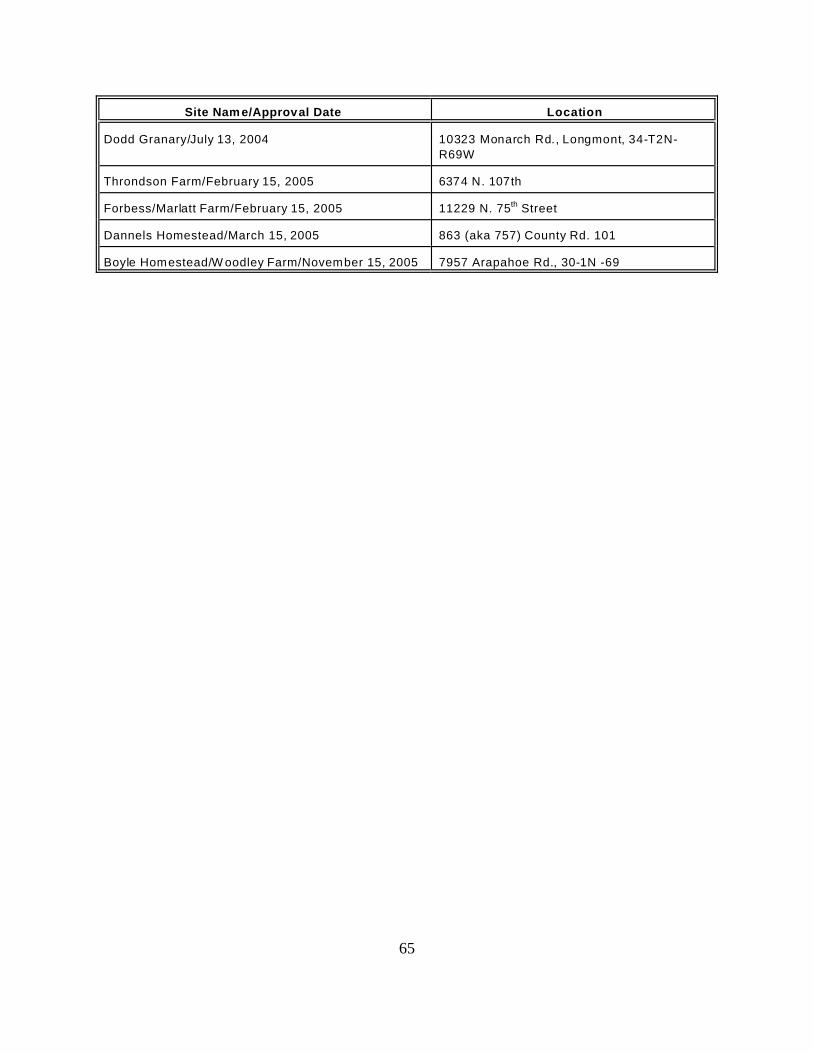
Site Nam e/Approval Date Location
65
Dodd Granary/July 13, 2004 10323 Monarch Rd., Longmont, 34-T2N-
R69W
Throndson Farm/February 15, 2005 6374 N. 107th
Forbess/Marlatt Farm/February 15, 2005 11229 N. 75th Street
Dannels Homestead/March 15, 2005 863 (aka 757) County Rd. 101
Boyle Homestead/W oodley Farm/November 15, 2005 7957 Arapahoe Rd., 30-1N -69
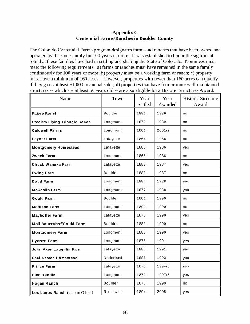
66
Appendix CCentennial Farms/Ranches in Boulder County
The Colorado Centennial Farms program designates farms and ranches that have been owned andoperated by the same family for 100 years or more. It was established to honor the significantrole that these families have had in settling and shaping the State of Colorado. Nominees mustmeet the following requirements: a) farms or ranches must have remained in the same familycontinuously for 100 years or more; b) property must be a working farm or ranch; c) propertymust have a minimum of 160 acres -- however, properties with fewer than 160 acres can qualifyif they gross at least $1,000 in annual sales; d) properties that have four or more well-maintainedstructures -- which are at least 50 years old -- are also eligible for a Historic Structures Award.
Name Town YearSettled
YearAwarded
Historic StructureAward
Faivre Ranch Boulder 1881 1989 no
Steele's Flying Triangle Ranch Longmont 1870 1989 no
Caldwell Farms Longmont 1881 2001/2 no
Leyner Farm Lafayette 1864 1986 no
Montgomery Homestead Lafayette 1883 1986 yes
Zweck Farm Longmont 1866 1986 no
Chuck Waneka Farm Lafayette 1883 1987 yes
Ewing Farm Boulder 1883 1987 no
Dodd Farm Longmont 1884 1988 yes
McCaslin Farm Longmont 1877 1988 yes
Gould Farm Boulder 1881 1990 no
Madison Farm Longmont 1890 1990 no
Mayhoffer Farm Lafayette 1870 1990 yes
Moll Bauernhof/Gould Farm Boulder 1881 1990 no
Montgomery Farm Longmont 1880 1990 yes
Hycrest Farm Longmont 1876 1991 yes
John Aken Laughlin Farm Lafayette 1885 1991 yes
Seal-Scates Homestead Nederland 1885 1993 yes
Prince Farm Lafayette 1870 1994/5 yes
Rice Rundle Longmont 1870 1997/8 yes
Hogan Ranch Boulder 1876 1999 no
Los Lagos Ranch (also in Gilpin) Rollinsville 1894 2005 yes

67
BIBLIOGRAPHY
Bibliography
Abbott, Carl; Leonard, Stephen J., and McComb, David. Colorado: A History of the CentennialState 3rd ed. Niwot: University Press of Colorado, 1994.
Anderson, M. M. The Mining Camps: Salina & Summerville. Boulder, CO: Junction House,2005.
Benedict, Diane Goode. Refuge in the Valley: 1800s Pella, Colorado. Lyons: CO: ApplicationsPlus, 2004.
Betasso, Ernie. “Oral history interview with Ernie Betasso.” Interviewed by John Hess, 15January 1983. At Carnegie Branch Library for Local History, Boulder Public LibrarySystem, OH0225, Boulder, CO.
Boulder Commercial Association. “Agricultural Possibilities of Boulder County.” N.p.: BoulderCommercial Association, n.d. [ca. 1907]. At Carnegie Branch Library for Local History,Boulder Public Library System, folder 300 b01 f12, Boulder, CO.
“Boulder County Farmers Had Successful Year During 1945.” Boulder Daily Camera, 31December 1945.
“Boulder County Remains a Major Turkey Center, But Raiser Hit by Low Prices.” Daily Camera(29 September 1961). In folder 328 B132 F03, Carnegie Branch Library for LocalHistory, Boulder, CO.
"Boulder Valley, 'The Garden Spot of Colorado." The Daily Camera Industrial Number (8January 1910).
Colorado. Boulder County. 1870 U.S. Census, agriculture schedule. Cited from: University ofVirginia Library, Geospatial and Statistical Data Center. Historical Census Browser.<http://fisher.lib.virginia.edu/collections/stats/histcensus/> cited 10 October 2005.
Colorado. Boulder County. 1890 U.S. Census, agriculture schedule. Cited from: University ofVirginia Library, Geospatial and Statistical Data Center. Historical Census Browser.<http://fisher.lib.virginia.edu/collections/stats/histcensus/> cited 10 October 2005.
Colorado. Boulder County. 1900 U.S. Census, agriculture schedule. Cited from: University ofVirginia Library, Geospatial and Statistical Data Center. Historical Census Browser.<http://fisher.lib.virginia.edu/collections/stats/histcensus/> cited 10 October 2005.
Colorado. Boulder County. 1920 U.S. Census, agriculture schedule. Cited from: University ofVirginia Library, Geospatial and Statistical Data Center. Historical Census Browser.<http://fisher.lib.virginia.edu/collections/stats/histcensus/> cited 10 October 2005.
68
Colorado. Boulder County. 1930 U.S. Census, agriculture schedule. Cited from: University ofVirginia Library, Geospatial and Statistical Data Center. Historical Census Browser.<http://fisher.lib.virginia.edu/collections/stats/histcensus/> cited 10 October 2005.
Colorado. Boulder County. 1940 U.S. Census, agriculture schedule. Cited from: University ofVirginia Library, Geospatial and Statistical Data Center. Historical Census Browser.<http://fisher.lib.virginia.edu/collections/stats/histcensus/> cited 10 October 2005.
Colorado. Boulder County. 1950 U.S. Census, agriculture schedule. Cited from: University ofVirginia Library, Geospatial and Statistical Data Center. Historical Census Browser.<http://fisher.lib.virginia.edu/collections/stats/histcensus/> cited 10 October 2005.
Colorado Agricultural College, Extension Service. “Cooperative Extension Work in Agricultural
and Home Economics.” N.p.: Colorado Agricultural College, U.S. Department ofAgriculture, and Boulder County Cooperating Extension Service, 29 December 1928.
Colorado State Grange. Colorado State Grange History: 1874-1975. N.p.: Colorado StateGrange, 1975.
Convery, William J. III. Pride of the Rockies: The Life of Colorado’s Premiere Irish Patron,John Kernan Mullen. Boulder, CO: University Press of Colorado, 2000.
“Corn, Hay, Winter Wheat Among County’s Top Value Farm Products.” Boulder Daily Camera,1 June 1960.
Corson, Dan, and Noel, Tom. Boulder County: An Illustrated History. Carlsbad, CA: HeritageMedia Corp., 1999.
“County Agent Surveys 1946 Yield of Farms and Dairying Business.” Boulder Daily Camera, 1January 1947.
Dyni, Anne. “The Grange Movement in Boulder County.” Prepared for the Boulder HistoricContext Project, 1992.
Dyni, Anne. Pioneer Voices of the Boulder Valley: An Oral History. Boulder, CO: BoulderCounty Parks and Open Space Department, 1999.
Fetter, Richard. Frontier Boulder. Boulder, CO: Johnson Publishing Company, 1983.
Gladden, Sanford Charles. Boulder Firsts: A Source-Book of Beginnings in Boulder, Colorado. N.p: pre-publication photocopy of manuscript prepared by Boulder Genealogical Society,1972.
Juliusson, Lara. “Boulder County Colorado Major Transportation Routes, Pre 1860 to 1920.” Boulder, CO: Boulder Planning Department, May 1992.
69
Large, Dorothy. Old Burlington: First Town on the St. Vrain 1860-1871. Longmont, CO: St.Vrain Publishing Co., 1984.
Leonard, Stephen J. Trials and Triumphs: A Colorado Portrait of the Great Depression, withFSA Photographs. Niwot, CO: University Press of Colorado, 1993.
McAlester, Lee, and Virginia McAlester. A Field Guide to American Houses. New York:Alfred A. Knopf, 1984.
McWilliams, Carl. “Unincorporated Boulder County Historic Sites Survey Report.” Preparedfor Boulder County Parks and Open Space Department. February 2000.
McWilliams, Carl. “Unincorporated Boulder County Historic Sites Survey Report.” Preparedfor Boulder County Parks and Open Space Department. February 2003.
Native Cultural Services and Paragon Archaeological Consultants, Inc. “Results of anArchaeological and Historical Inventory of Southern Rabbit Mountain & North FoothillsOpen Space. Boulder County, Colorado.” Prepared for Boulder County Parks and OpenSpace Department. 16 December 1996.
Newby, Betty Ann. The Longmont Album: History and Folklore of the St. Vrain Valley. Virginia Beach, VA: Donning Company Publishers, 1995.
Noble, Allen G., and Richard K. Cleek. The Old Barn Book: A Field Guide to North AmericanBarns and Other Farm Structures. New Brunswick, NJ: Rutgers University Press, 1995.
Noble, Allen G. Wood, Brick and Stone: The North American Settlement Landscape, Volume 2:Barns and Farms Structures. Amherst, MA: University of Massachusetts Press, 1984.
Pettem, Silvia. “Roads of the Mountains and Plains.” Boulder, CO: Boulder PlanningDepartment, 1996.
“Records and Correspondence 1872-1873 of Boulder County Agricultural Society.” Folder BHS328 b043 f01. Boulder, CO: Carnegie Branch Library for Local History, Boulder PublicLibrary System.
Saul, Norman E. “Mill Town Kansas in the Age of Turkey Red,” Kansas History: A Journal ofthe Central Plains 23 (Spring-Summer 2000).
Schooland, J.B. Boulder, Then and Now: Picturesque Boulder and Gems of Boulder County. Boulder, CO: Pruett Press, Inc., 1967.
Smith, Phyllis. A Look at Boulder from Settlement to City. Boulder, CO: Pruett PublishingCompany, 1981.

70
Soil Conservation Service of Boulder Valley Soil Conservation District . “Rural Recreation:New Opportunities on Private Land.” Soil Conservation Service of Boulder Valley SoilConservation District Newsletter. Boulder, CO: July 1964.
“22,794,588 Value of Farm-Ranch Products of Boulder County in 1950.” Boulder Daily Camera,23 October 1952.
U.S. Department of Agriculture, Rural Development. “Farm Marketing, Supply, and ServiceCooperative Historical Statistics.” Cooperative Information Report 1, Section 26. Revised August 2004. Cited from <http://www.rurdev.usda.gov/rbs/pub/cir1s26.pdf >cited 20 March 2006.
U. S. Federal Housing Authority. “Open this Door to Farm Property Improvement.” FHA 136,1st Edition. Washington, D.C.: Federal Housing Administration, n.d.
Wickens, James F. Colorado in the Great Depression. New York: Garland Publishing, 1979.
“Without Water, Winter Wheat Withers.” Boulder Daily Camera (15 November 1964). AtCarnegie Branch Library for Local History, Boulder Public Library System, folder 328B132 F03, Boulder, CO.
Additional information about specific property types and their listing in the National Registercan be found in relevant National Register bulletins, or National Register Multiple PropertyDocumentation forms relating to their history in Colorado.
National Register BulletinsU.S. Department of the Interior, National Park Service, National Register, History and Education.
Guidelines for Evaluating and Documenting Rural Historic Landscapes (#30). Washington, D.C.: U.S. Department of the Interior, 1989; Revised 1999.
U.S. Department of the Interior, National Park Service, National Register, History and Education. Guidelines for Evaluating and Registering Cemeteries and Burial Places (#41). Washington, D.C.: U.S. Department of the Interior, 1992.
U.S. Department of the Interior, National Park Service, National Register, History and Education. How to Apply the National Register Criteria for Evaluation (#15). Washington, D.C.:U.S. Department of the Interior, 1990; Revised 1991, 1995, 1997; Revised for Internet1995, 2001, 2002.