Embed Size (px)
Citation preview

BELLINGHAMBELLINGHAMBELLINGHAM
TRAIL GUIDETRAIL GUIDETRAIL GUIDE
April 2013


Bay to Baker Trail
& Little
Squalicum Park
Cornwall
Park
Maritime
Heritage
Park
Old
Village
Trail
Railroad
Trail
Whatcom
Falls
Park Civic
Field
Complex
Sehome
Arboretum
Connelly Creek
Nature Area
South Bay
Trail /
Lower
Padden Creek
Trails
Fairhaven
Park
Lake Padden
Park Arroyo
Park
Interurban
Trail
Whatcom Creek
Trail
Bloedel
Donovan
Park
Big Rock
Garden
A digital version of this Park Trail Guide available at www.cob.org
Trail Maps are available at the
Bellingham Parks & Recreation Main Office,
210 Lottie St Bellingham, WA, 98225
3
8
12
2 13
9
9
7
7
15
14
6
14 + 15 15
11 5
110
Downtown
Trails 6
Northridge
Park 10
Cordata Park
Division
Street Trail
4
4
Map numbers shown

BAY TO BAKER TRAIL, SQUALICUM CREEK PARK TRAILS AND LITTLE SQUALICUM PARK TRAILS
TRAIL DESCRIPTION These trails access Birchwood Park, Squalicum Creek Park, Little Squalicum Park and Squalicum Beach. Dogs must be on leash, except at Little Squalicum Park.
TRAILHEADS
Little Squalicum Park, 640 Marine Dr.
Birchwood Park, 2709 Cedarwood Ave.
Squalicum Creek Park, 1001 Squalicum Way Port of Bellingham parking area - From Port of Bellingham's parking
area at the west end of Roeder Avenue, take a low tide beach walk on sand and cobblestones along the Bellingham Bay shoreline. Please leash your dog on the beach.
MILEAGE
0.7 mile – Squalicum Beach to Pinewood Ave. /Patton St.
1.2 miles –Squalicum Beach to Squalicum Parkway at the Northwest Ave. Bridge.
1.2 Miles – Squalicum Creek Park, from Squalicum Way to Squalicum Beach.
Little Squalicum Park is a community park established in 1976. Facilities include beach, trails, interpretive displays and parking. Little Squalicum Creek runs through this park.
Squalicum Creek Park is a community park established in 2002. Facilities include restroom, ballfield, parking, and trails. Future phases will add a playground, picnic facilities, fenced dog park, and basketball.
Birchwood Park is a neighborhood park established in 1996. Facilities include playground, picnic shelter, parking and open field.
Squalicum Beach is owned and managed by the Port of Bellingham. Dogs must be on-leash.

!P
!P
!P
!P
!P
!P!P
I *!²
!²I *
!²I *
I *!²
WEST STSqualicum Creek
LAFAYETTE STSQ
UALIC
UM W
AY
LYNN ST
SQUA
LICUM
WAY
MERIDIAN ST
MONR
OE ST
ELDR
IDGE A
VE
CEDA
RWOO
D AV
E
NORTHWEST AVE
W ILL
INOI
S ST
ELM ST
MARINE DR
BENNETT DR
BIRCH
WOOD A
VE BROADWAY ST
PINEWOOD AVE PATTON ST
ROED
ER AV
E
GIRARD ST
W MA
PLEW
OOD A
VE
Bay t
o Bak
er Tra
il, Sq
ualic
um C
reek P
ark&
Little
Squa
licum
Park
Map
rev. D
ec 20
12
Map
1
Little
Sq
ualic
um
Park
00.2
50.1
25Mi
les
Squa
licum
Cree
k Park
Corn
wall
Park
Eliza
beth
Park
Beac
h
Walk
Squa
licum
Beac
hTib
ury
PierPr
imary
Trail
(6'-1
2' wi
de)
Mino
r Trai
ls (1'
-1 1/2
' wide
)
Birc
hwoo
dPa
rk
Bay t
o Bak
er Tra
il
µ
Colum
biaEle
menta
ry Sc
hool
Birch
wood
Eleme
ntary
Scho
ol
Bellin
gham
Tech
nical
Colle
ge
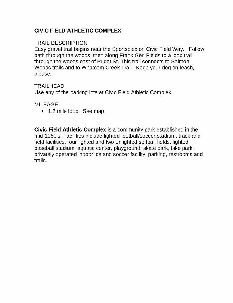
CIVIC FIELD ATHLETIC COMPLEX TRAIL DESCRIPTION Easy gravel trail begins near the Sportsplex on Civic Field Way. Follow path through the woods, then along Frank Geri Fields to a loop trail through the woods east of Puget St. This trail connects to Salmon Woods trails and to Whatcom Creek Trail. Keep your dog on-leash, please. TRAILHEAD Use any of the parking lots at Civic Field Athletic Complex. MILEAGE
1.2 mile loop. See map Civic Field Athletic Complex is a community park established in the mid-1950's. Facilities include lighted football/soccer stadium, track and field facilities, four lighted and two unlighted softball fields, lighted baseball stadium, aquatic center, playground, skate park, bike park, privately operated indoor ice and soccer facility, parking, restrooms and trails.

Puge
t St
Fraser St
Lakeway Dr
St Pa
ul St
Moore
St
Orlea
ns St
Potter St
Civic Field Way
Pacif
ic St
Gladstone St
York St
Racin
e St
Quee
n St
Neva
da S
t
St Paul Ln
Toledo Ct
Expre
s sDr
Moore
St
SKATE PARK
JOEMARTIN
STADIUM
CIVICFIELD
GERI 4
SPORTS-PLEX
Æü
CIVIC FIELD ATHLETIC COMPLEXAND CIVIC TRAIL MAP
GERI FIELDS
Salmon Woods Trailscontinue
.
Civic Trail Loop .....1.2 miles out and backOther trailsCivic Field Track.....400 meters (.25 mile)
start/finish
Map 2
0 140 280 420 56070Feet
ARNE HANNAAQUATIC CENTER& DOWNER BALL FIELDS
rev. 5/2012
BIKEJUMPS
Æü
Æü
Æü
.15mi. lo
op
±
CARL COZIERELEMENTARYSCHOOL

CONNELLY CREEK TRAIL TRAIL DESCRIPTION Relatively flat terrain along Connelly Creek through wooded canopy and open meadows. Dogs must be on leash. TRAILHEADS Limited parking on gravel shoulder at the south access on Donovan Ave. at 30th St. North access from Ferry Ave. east of Sehome High School near Bill McDonald Parkway. Follow the sidewalk on the south side of Donovan west for one block to Happy Valley Park where the trail continues south to Old Fairhaven Parkway. There are numerous neighborhood access points.
MILEAGE
1 mile - Ferry Ave. to Donovan Ave. Connelly Creek Nature Area was established in 1981. Some of the largest Sitka Spruce trees in the city are found near the creek. Happy Valley Park is a neighborhood park established in 1995. Facilities include playground, picnic table and trails.

!P 32ND
ST
SAMISH WAY24
TH S
T
DONOVAN AVE
BILL MCDONALD PKWY
OLD FAIRHAVEN PKWY
30TH
ST
25TH
ST
FIELDING AVE
DOUGLAS AVE
HARRIS AVE
24TH
ST
34TH
ST
23RD
ST
24TH
ST
25TH S
T
35TH
ST
TAYLOR AVE
DOUGLAS AVE
MILL AVE
S COL
LEGE
DR
32ND
ST
FERRY AVE
MCKENZIE AVE
36TH S
T
COWGILL AVE
27TH
ST
26TH
ST
WILSON AVE
31ST
ST
RI D GEMONT WAY
LARRABEE AVE
W 32
ND ST
DONOVAN AVE
VOLT
AIRE
CT
31ST
PL
30TH
ST
BONN
IE LN
DURBIN CT
MCKENZIE AVELARRABEE AVE
MILL AVE
WILSON AVE
DONOVAN AVE
23RD
ST
36TH
ST
31ST
ST
36TH
ST
36TH
ST
TAYLOR AVE
WILSON AVE
SehomeArboretum
SehomeHigh School
WesternWashingtonUniversity
ConnellyCreekNatureArea
Nov. 2011
Happy ValleyPark
FairhavenCollege
Interurban Trail
Use Sidewalk
Happy ValleyCommunity Garden
Happy ValleyElementary School
.not to scale
Map 3
n
n
n
n Connelly Creek30th
St. C
k
Conn
elly C
reek
Taylor Ck
Padden Creek
Joe's Garden
.4 mi. Ferry Ave. to Taylor St.
.6 mi. Taylor St. to Donovan Ave.
.3 mi. Donovan/30th St. to Old Fairhaven Pkwy.
CONNELLY CREEK TRAIL
§¦5

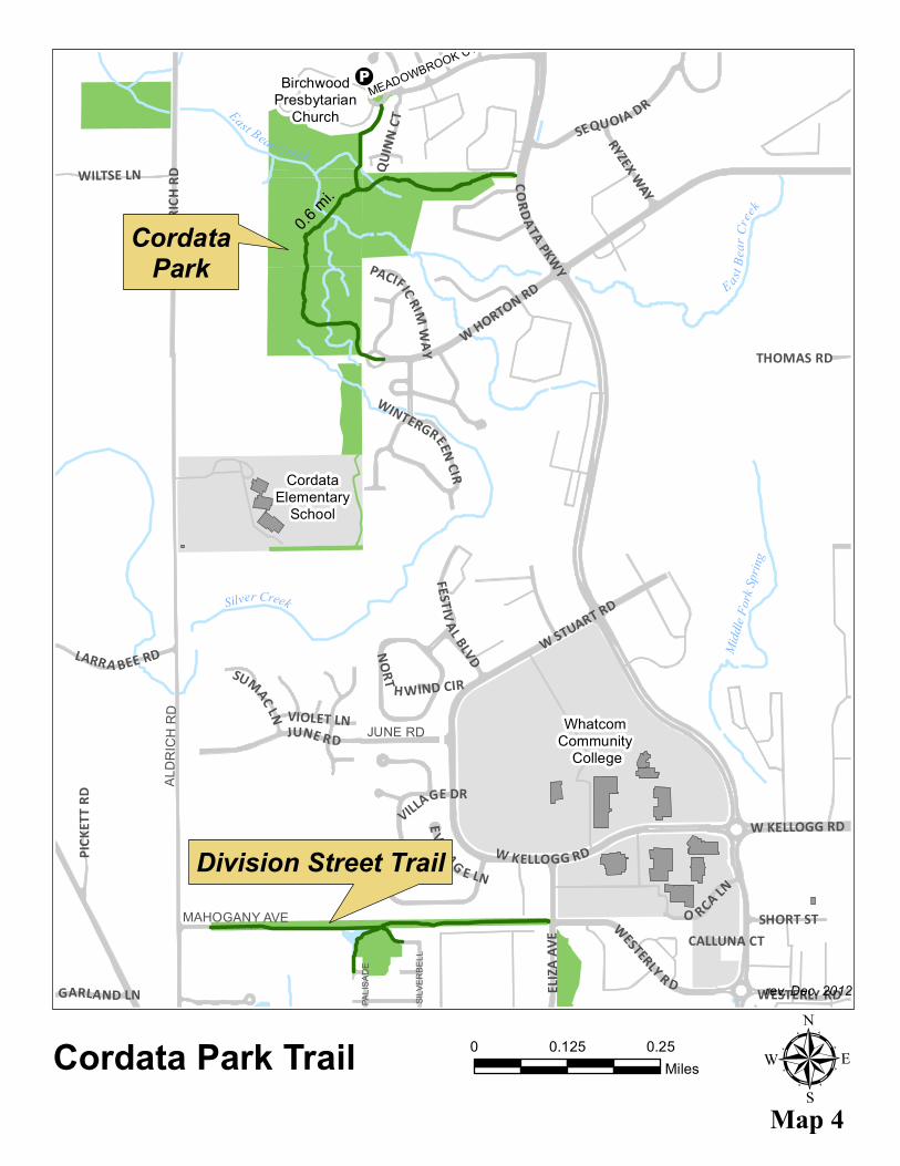
CORDATA PARK
Cordata Park, acquired by the City in 2007, features trails, benches and interpretive signs. Additional park development is planned for the future. Birding opportunities abound with the variety of habitats. Dogs on-leash.
TRAILHEADS
Walk-in trail access at west end of Horton Road and off of Cordata Parkway, north of Horton Road. No on-street parking.
Trail users may park at Birchwood Presbyterian Church, located at 400 Meadowbrook Ct., in signed designated spaces only. Please respect their private property.
E astBe
arCr
ee k
East Bear Creek
Midd
le Fork
Sprin
g
Silver Creek
MEADOWBROOK CT
JUNE RD
MAHOGANY AVE
PALIS
ADE
ALDR
ICH
RD
SILVE
RBEL
L
ALDR
ICH RD CORDATA PKWY
W HORTON RD
JUNE RD
W STUART RD
W KELLOGG RD
ELIZA
AVE WESTERLY R D
PICKE
TT RD
SEQUOIA DR
WILTSE LN
O RCA LN
THOMAS RD
FESTIVAL BLVD
SHORT ST
LARRA BEE RD
VILLAGE DR
RYZEX WAY
SUMAC LN VIOLET LN
QUINN
CT
GARLAND LN
PACIFIC RIMWAY
E VILLAG E LN
WINTERGREEN CIR
NORT H WIND CIR
CALLUNA CT
W KELLOGG RD
WESTERLY RD
Cordata Park TrailMap 4
rev. Dec. 2012
CordataPark
0 0.250.125Miles
0.6mi.
µ
BirchwoodPresbytarian
Church
Division Street Trail
CordataElementary
School
Whatcom Community
College
!P

CORNWALL PARK TRAILS TRAIL DESCRIPTION Level gravel and paved trails in the park interior. Gravel trails in wooded areas. Dogs must be on a leash, please. TRAILHEADS: Three main park entrances and parking areas:
Meridian St. at Squalicum Way.
Meridian St. at Maplewood Ave.
North end of Cornwall Ave. Cornwall Park is a community park established in 1909. Facilities include two picnic shelters, two playgrounds, a spray park, disc golf, trails, restrooms, parking, basketball court, tennis & pickle ball courts, multi-purpose field, horseshoe pits, barbecue grills and picnic tables. Squalicum Creek provides seasonal interest with salmon runs and waterfalls. Maps of the Cornwall Park disc golf course and a Cornwall Park history brochure are available at the Cornwall Park office. BUG LAKE TRAIL TRAIL DESCRIPTION Unimproved dirt trail with some un-bridged creek crossings. Fishing is allowed. See fishing regulations. Portions of the trail may be impassable during high water. Dogs on leash. TRAILHEAD From Squalicum Parkway at intersection with Birchwood Ave. No parking. MILEAGE
0.1 mile one-way along south side of the lake

COOLIDGE DR
VALLETTE ST
PEABODY ST
SQUALICUM PKWY
W IN
DIAN
A ST
BIRCH
WOO
D AV
E
MERIDIAN ST
St. J
osep
h'sHo
spita
l
Parkv
iew
Eleme
ntary
Scho
ol
Cornw
all Par
k
Publi
cRo
seGa
rden
Bug L
ake
IA
IA
IA
S qua
lic u
mCr
eek
Parks
and R
ecrea
tion
Main
Offic
e I*
Shelt
er
Shelt
er
I*
Horse
shoe Pit
s
Tenn
isCo
urts
Disc
Golf
±
ÆI ÆI
Playg
roun
d
TO Bask
etball
Cour
t
Cornw
all Par
k Trai
ls and
Bug L
ake Tr
ail Ma
p§ ¦5Squa
licum
Cree
k Gree
nway
Open
Spa
ce
Squa
licum
Cree
k Gree
nway
Open
Spa
ce
Playg
roun
d&
Spray
park
Map
5
00.1
250.0
625
Miles
City
of Be
llingh
am
Parks
& R
ecrea
tion
3424
Meri
dian S
t., Be
llingh
am, W
A 98
225
IA
ÆI
rev. O
ct. 20
12
§ ¦5
Prim
ary Tr
ail (6
'-12'
wide
)Mi
nor T
rails
(1'-3'
wide
)
Lawn
Lawn

1. Territorial Courthouse (a.k.a. Richards Building) (1858, NRHP)2. Pickett House (1856, NRHP)3. First Congregational Church (c. 1902)4. Immanuel School of Industries (1906, NRHP)5. Lottie Roth Block (1890, NRHP)6. Great Northern Freight Depot (1905)7. Great Northern Passenger Depot (1927, NRHP)8. Andall Building (1913)9. Waterfront Tavern (c. 1910)10. New Whatcom City Hall (1892-93, NRHP)11. Salmon Woman Totem Pole (2000)12. Bellingham City Hall (1939)13. Whatcom County Railway & Light Power Station (1908-1912)14. Elizabeth Park (1906)15. Aftermath Club (1904, NRHP)
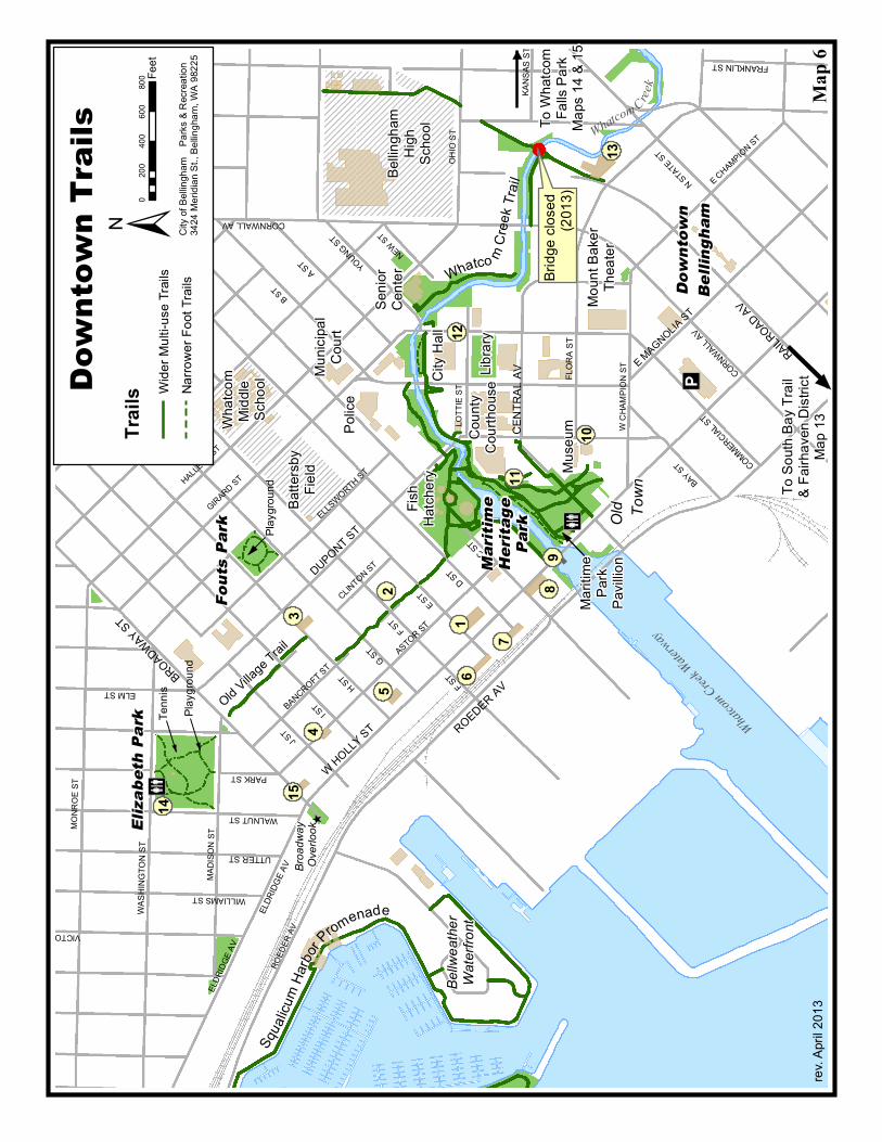
DOWNTOWN TRAILS
OLD VILLAGE TRAIL TRAIL DESCRIPTION: This urban trail through the Lettered Streets neighborhood is sometimes shared with traffic entering driveways and private property. The trail connects Old Town with Elizabeth Park and surrounding neighborhoods. Please keep your dogs on leash along this busy, urban trail.
TRAILHEADS: North access at Broadway St. South access and parking lot at Maritime Heritage Park.
MILEAGE: 0.5 mile from Broadway St. to Maritime Heritage Park
WHATCOM CREEK TRAIL (WEST) and Maritime Heritage Park See Maps 14.
DOWNTOWN WATERFRONT TRAILS Squalicum Harbor Trail, maintained by the Port of Bellingham, starts at Bellwether on the Bay, located on Bellwether Way, and follows the Squalicum Harbor shoreline.
South Bay Trail starts at Railroad and Maple and runs along Bellingham Bay. See Map 13. Dogs must be on leash.
THE DOWNTOWN HISTORICAL LANDMARKS WALKING TOUR Several historical landmarks located in Downtown Bellingham are shown on this map. For a detailed history of each landmark, visit the City’s history website:
http://www.cob.org/services/planning/historic/Pages/historic-tours.aspx
Legend
FLOR
A ST
ASTOR ST
CORNWALL AV
COMMERCIAL ST
BANCROFT ST
D ST
C ST
G ST
F ST
WASH
INGT
ON ST
ELDR
IDGE A
V
E MAGNOLIA ST
ELLSWORTH ST
FRANKLIN ST
A ST YOUNG ST
KANS
AS ST
UTTER ST
BROADWAYST
ELM ST
ROEDER AV
CORNWALL AV
I ST
F ST
H ST
N STATE ST
ROED
ER AV
J ST
ELDR
IDGE A
V
WALNUT ST
VICTORST
MONR
OE ST
E ST
W HOLLY ST
OHIO
ST
B ST
HALLECK ST
WILLIAMS ST
GIRARD ST
CENT
RAL A
V
DUPONT ST
PARK ST
MADI
SON
ST
CLINTON ST
E MAGNOLIAST
BAY ST
LOTT
IE ST
W CH
AMPIO
N ST
E CHAMPION ST
NEW ST
RAILROAD AV
Muse
um
Bellin
gham
High
Scho
ol
Elizabe
th Par
k
Mariti
meHe
ritage
Park
Down
town T
rails
I*
Whatc
omMi
ddle
Scho
ol
Batte
rsby
Field
±020
040
060
080
0 Feet
City o
f Bell
ingha
m P
arks &
Rec
reatio
n34
24 M
eridia
n St.,
Bellin
gham
, WA
9822
5
Whatco mCr
eek T
rail
Munic
ipal
Court
WhatcomCreek
Waterway
Moun
t Bak
erTh
eater
IAOld Villag
e Trail
Downto
wnBel
lingham
Bellw
eathe
rWa
terfro
nt
Old To
wn
Mariti
mePa
rkPa
villion
2
3
14
10
12
11 To So
uth Ba
y Trai
l& F
airha
ven D
istric
tMa
p 13
Fouts P
ark
Broa
dway
Ov
erloo
k
I*Te
nnis
Playg
round
Playg
round
98
7
61
5
415
13
Coun
tyCo
urtho
use
Librar
y
City H
all
Senio
rCe
nter
Police
Fish
Hatch
ery
Trail
s Narro
wer F
oot T
rails
rev. A
pril 2
013
Map
6
Squa
licum
Harbo
r P
romenade
Whatcom Creek
Wide
r Mult
i-use
Trail
s
To W
hatco
mFa
lls Pa
rkMa
ps 14
& 15
Bridg
e clos
ed
(2013
)

INTERURBAN TRAIL TRAIL DESCRIPTION The Interurban Trail connects the Fairhaven Historic District with Larrabee State Park following a former electric rail line. This is an easy trail, except for a steep section through Arroyo Park. Mostly wooded with some scenic views of Bellingham Bay, Chuckanut Bay and the San Juan Islands. Please keep your dog on leash. TRAILHEADS North access at 10th St. and Donovan Ave. South access with fee parking at Larrabee State Park. Several parking areas available - see map. MILEAGE
1.8 miles - 10th St. and Donovan Ave. to Arroyo Park.
6.6 miles - 10th St. and Donovan Ave. to Larrabee State Park. ARROYO PARK TRAILS TRAIL DESCRIPTION Moderate to difficult trails through densely wooded area. Chuckanut Creek runs through this park. Dogs may be off leash, if under voice control. TRAILHEADS Three parking areas – two east of Chuckanut Drive on Old Samish Rd. The third is at the North Chuckanut Trailhead parking lot south of Old Samish Rd., on the east side of N. Chuckanut Dr. MILEAGE
0.75 mile - Old Samish Rd. to California St. Arroyo Park was established in 1923. Facilities include parking and trails. The park is a starting point for Whatcom County and Larrabee State Parks’ extensive trail systems in the Chuckanut Mountains.

§¦I-5
12TH
ST
21ST
ST
CHUCKANU TDR N
HAWTHORN RD
OLDSAMISH RD
DONOVAN AVE
24TH
STWILLOW RD
HARRIS AVE14
T HS T
3 0TH ST 32NDST
FIELDSTONRD
HARRIS AVE
10TH
ST
DONO VAN AVE
OLD FAIRHAVEN PKWY
.6 mi. 10th St. to Rotary Trailhead1.2 mi. Rotary Trailhead to Old Samish Rd..8 mi. Old Samish Rd to California St.4 mi. California St. to Larrabee State Park
.Primary Trail (6'-12' wide)Secondary Trail (2'-4' wide)Minor Trails (1'-1 1/2' wide)
INTERURBAN TRAIL MAP
Æü
Æü
Æü
ÆüFairhavenPark
FairhavenMiddle School
Hoag'sPond
Fairhaven VillageGreen
PaddenLagoon Connelly
CreekNatureArea
Chuckanut Bay
ArroyoPark
Chuckanut Parklands(County)
INTE
RURB
ANTR
A IL
not to scale
RotaryTrailhead
rev. March 2013 To Larrabee State Park
Chuckanut BayOpen Space
ErodedSandstoneFormations
Beach Walk
See Lower Padden Trail Map
INTERURBAN TRAIL
Map 7
Æü
WoodstockFarm
n
Padden Creek
Chuckanut Creek
Hoag
's Cree
k
I[
I_
I_
Beach
Inspiration Point
InterurbanOpen Space
1/2 mile trail markers (2013)
Select paths shown.Please stay out of sensitive wetlands.

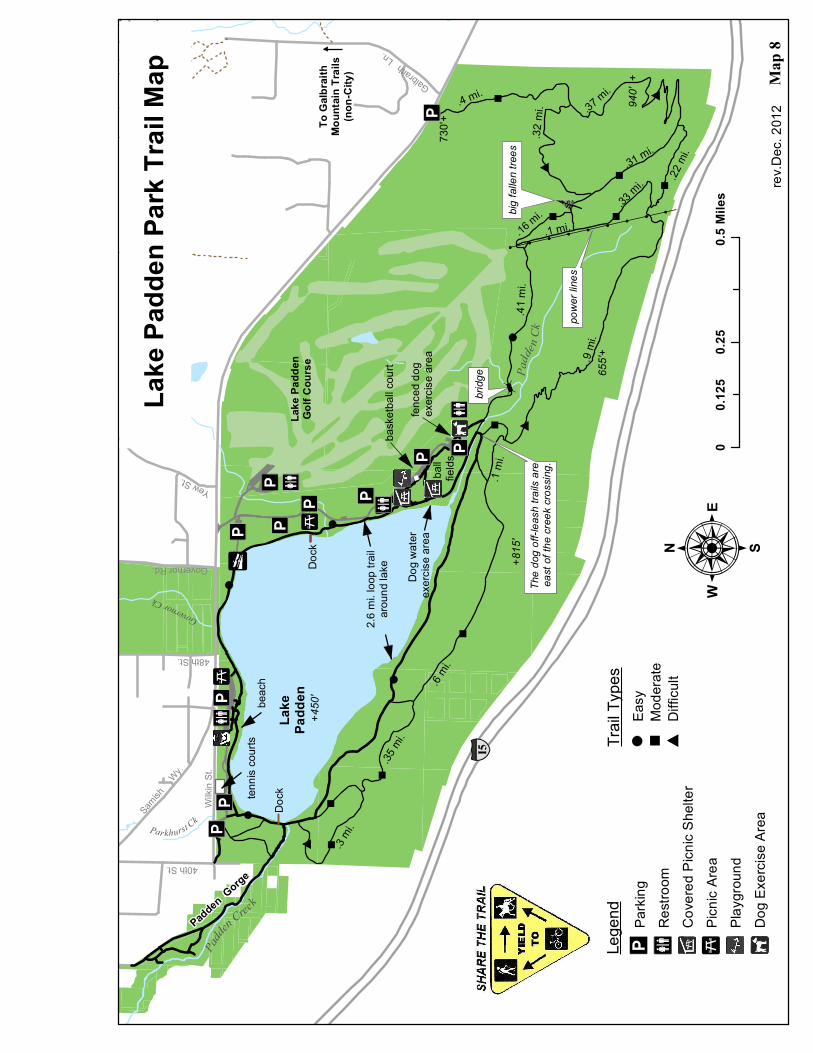
LAKE PADDEN PARK TRAILS TRAIL DESCRIPTION An easy loop trail goes around the lake through open and wooded areas. Moderately difficult dirt trails through the woods south and east of the lake with mostly hilly terrain. Horse trailer parking at the Wilkin St. trailhead. Horses must yield to pedestrians. Padden Gorge Trail follows the creek from the dam west of the lake to 36th St. Dogs must be on leash, except where noted. TRAILHEADS and PARKING
West Entrance off of Samish Way, East of 46th St.
East Entrance, off of Samish Way, East of Governor Rd.
Wilkin St. (east of 40th St.) This is also the horse trailer parking lot.
Trailhead parking and trail access on Samish Way across from Galbraith Lane.
MILEAGE
2.6 mile loop trail around the Lake.
5.1 miles of multipurpose trails south and east of the Lake. Lake Padden Park is a community park established in 1972. Facilities include two picnic shelters, playground, beach with swimming area, restrooms, trails, parking, basketball court, softball fields, multi-purpose fields, barbecue grills, picnic tables, and fenced dog park. Lake Padden was once the drinking water source for Bellingham. Lake Padden Golf Course was rated by Golf Digest as one of the best municipal courses in the state. This beautiful 18 hole golf course is a full service facility offering complete practice facilities, golf lessons, snack bar and club rentals. www.lakepaddengolf.com (360) 738-7400
!!
!!
!!
!!
!!
!!
!!
!!
!!
:
Lake
Padd
enGo
lf Cou
rse
Lake
Padd
en
Padden Gorge
To G
albrai
thMo
untai
n Trai
ls(no
n-Ci
ty)
00.2
50.5
0.125
Miles
§ ¦I5
Wilkin
St.
40th St.
Samish
Wy.
Governor Rd.
Galbraith Ln.
+815
'
+450
'
940'
+
655'+
730'+
#
#
#
#
"
""
"
"
"
""
"
"
bridg
e
powe
r line
s
big fa
llen t
rees
]]
.35 mi.
.6 mi.
.3 mi.
.1 mi
.
.9 mi
.
.41 m
i .
.16 mi.
.31 mi.
.22 m
i.
.33 mi.
.32 m
i. .37 mi.
.4 mi.
.1 mi.
2.6 m
i. loo
p trai
laro
und l
ake
â
Yew St.
I*
IA
I
IAI*
IAIA
IA IA I
IAIA
I*I
IA
I*I ADo
ck
Dock
fence
d dog
ex
ercise
area
bask
etball
court
tennis
court
s
Dog w
ater
exerc
ise ar
eaba
ll fie
lds
beac
h
Trail T
ypes
Lege
nd Parki
ngRe
stroo
mCo
vered
Picn
ic Sh
elter
Picnic
Area
Playg
round
Dog E
xerci
se Ar
ea
IA I* I
"Mo
derat
eEa
sy
#Dif
ficult
Lake
Padd
en Pa
rk Tr
ail M
apPa
dde
n Creek
Governor Ck
Padde
n Ck
Parkhurst Ck
Map
8
IA
rev.D
ec. 2
012
48th St.
The d
og of
f-leas
h trai
ls are
east
of the
cree
k cros
sing.

LOWER PADDEN TRAIL
TRAIL DESCRIPTION Easy trail with gently rolling terrain, following lower Padden Creek. Salmon can be observed in the late fall. Padden Lagoon has an observation deck for viewing marine wildlife and Fairhaven Harbor. Please keep your dogs on leash.
TRAILHEADS West access at Post Point Wastewater Treatment Plant (4th Ave.) East access in the Fairhaven Historic District at the intersection of 10th St. and Donovan Ave. Several access points from neighborhood streets.
MILEAGE
0.4 mile - from 4th St. to 10th St.
FAIRHAVEN PARK TRAILS
TRAIL DESCRIPTION Mostly flat gravel and dirt trails in wooded park setting. In late fall salmon can be observed in Padden Creek. Dogs must be on leash.
TRAILHEAD Parking lot in Fairhaven Park on Chuckanut Drive.
MILEAGE
0.5 mile of loop trails
Fairhaven Park is a community park established in 1906. Facilities include two picnic shelters, a pavilion, a playground, a spray park, a basketball court, tennis courts, trails, a multi-purpose field, parking, restrooms, barbecue grills and picnic tables. Padden Creek provides seasonal interest with salmon runs and waterfalls.

WILL
OW RD
FAIR
HAVE
NPA
RKWA
Y
HAWTH
ORNRD
MIDD
LEFIE
LDRD
BAYS
IDE P
L
DONO
VAN
AV
10TH ST
15TH ST
16TH ST
11TH ST
12TH ST
4TH ST
6TH ST
8TH ST
MCKE
NZIE
AV
DONO
VAN
AV
HARR
IS AV
WILS
ON AV LIN
DSAY
AV
22ND ST
23RD ST
TERR
ACEP
L
WILL
OWRD
PLWILL
OWCT
N
CHUCKANUTDR
BAYSIDE RD
18TH ST
19TH ST
20TH ST
21ST ST
DONO
VAN
AV
17TH ST
MILL
AV
14TH ST
HARR
IS AV
TAYL
OR AV
13TH ST
BAYS
IDE RD
20TH ST
LARR
ABEE
AV
25THST
22ND ST
4TH ST
COWG
ILL AV
DOUG
LAS A
V
BENN
ETT A
V
11TH ST
12TH ST
CODY
AV
24TH ST
JULIA
AV
PARK
RIDG
E RD
HAPP
Y CT
IRIS
LN
19TH ST
UNDE
RHILL
RD
SHOR
E-WO
OD D
R
GAMB
IER AV
JULIA
AV
COWG
ILL AV
DOUG
LAS A
V
KNOX
AV
WILS
ON AV
MCKE
NZIE
AVIA
I*
I*
Low e
rPad
denT
rail
Fairh
aven
Midd
leSc
hool
B e l l
i n g
h a m
B a
y
I nt e
r urb
anTr
ail Shelt
erEn
tranc
e
Pavil
lion
IAI*
Spray
Park
&Pla
ygro
und
Bellin
gham
Te
nnis
Club
IA
Padd
enLa
goon
To Ar
royo P
ark a
ndLa
rrabe
e Stat
e Park
(Port
owne
d)
IH
Taylo
r Do
ck
Marine
Park
Fairha
ven
Park
Fairha
venVill
ageGre
en
Comm
unity
Ga
rden
SouthBayTrail
025
050
075
01,0
001,2
501,5
0012
5Fe
et
±Ci
ty of
Bellin
gham
Pa
rks &
Rec
reatio
n34
24 M
eridia
n St.,
Bellin
gham
, WA
9822
5
Lower
Padden
Trail
& Fair
haven
Park T
rails
Padd
enCr
eek
^Ov
erloo
k
Post
Point
Waste
water
Plant
Map 9
Beac
h
Lege
nd Prim
ary Tr
ailSe
cond
aryTra
ilMi
nor T
rail
Upda
ted: O
ct. 20
12
IA

NORTHRIDGE PARK TRAILS Northridge Park, established in 1991, has trails winding through second growth Douglas Fir forest with wetland pockets. Dogs must be on leash. TRAIL DESCRIPTION There are multiple gravel connector trails to neighborhood streets and one main loop trail through Northridge Park. Three trail segments contain steps. TRAILHEADS Neighborhood street parking only. Trail access at E. McLeod Road, Carrington Way, Magrath Road, Woodside Way, and Chandler Parkway. MILEAGE
0.7 mile – Main Loop Trail
0.2 mile – Chandler Parkway to Northridge Park Loop o Contains steps
0.3 mile – E. McLeod Road to Northridge Park Loop o Contains steps

SPRI
NGLA
ND LN
SPYGLASS DR
WEST HILLS PL
WOOD
SIDE W
AY
BRIST
OL W
AY
MAGRATH RD
CARRINGTON WAY
LAHT
I DR
SUSS
EX DR
BRANDYWINE WAY
TANGLEWOOD LN
HIGH
FIELD
CT
BRID
LEWO
OD C
T
WELL
ING
RD
SPRIN
G COU
LEE R
D
BARK
LEY B
LVD
E MCL
EOD
RD
E SUN
SET D
R
CHANDLER PKWY
HANNEGAN RD
rev. O
ct.20
12
St. C
lair
Deten
tion
Basin
Squa
licum
High S
choo
l
Railro
ad Tr
ailMa
p 11
KLIP
SUN
TRAI
L
Map
10
Silve
r Bea
chPr
eserv
eBa
rkley
Tunn
el
NORT
HRID
GE PA
RK TR
AILS
0.2 m
i.
0.3 mi.
Main
Loop
Trail
0.7 m
i.0.1
mi.
0.1 mi.0.1 mi.
0.05 m
i.0.1
mi.
0.1 mi.
NORT
HRID
GEPA
RK
steps
steps
steps
steps
µ0
0.25
0.125
Miles
Prim
ary Tr
ail (6
'-12'
wide)
Mino
r Trai
l (1'-1
1/2'
wide)
Othe
r
Sylvan P
ond
0.2 mi. public trail (ends at utility road)

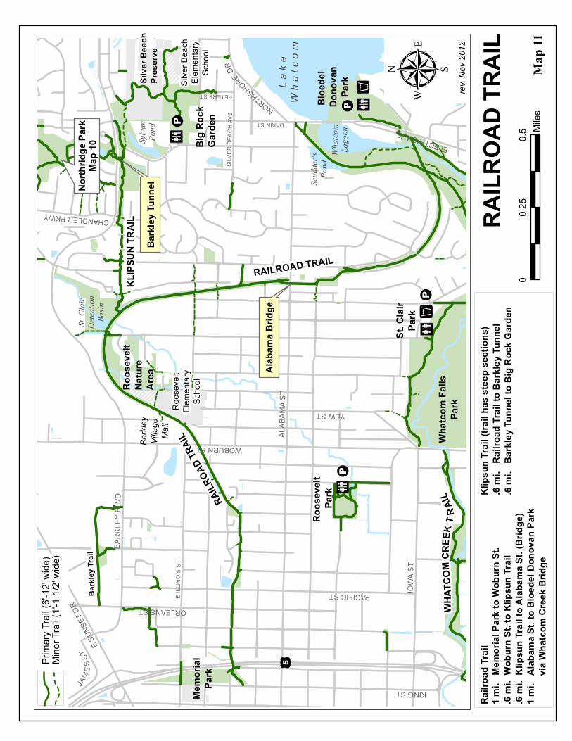
RAILROAD TRAIL
TRAIL DESCRIPTION Gentle grade, gravel trail. Views of Bellingham Bay from the Alabama Street Overpass. Wildlife and marsh birds may be observed at St. Clair Pond, Scudder's Pond and Lake Whatcom. Please keep dogs on leash.
TRAILHEADS East access from the parking lot at Bloedel Donovan Park. West access at Memorial Park on King St. Many access points from neighborhood streets.
MILEAGE
3.2 miles - Memorial Park to Bloedel Donovan Park.
KLIPSUN TRAIL
TRAIL DESCRIPTION Steep grade, gravel trail with some steps. This trail connects the Railroad Trail to Northridge Park. Dogs must be on-leash.
TRAILHEADS Parking at Big Rock Garden. East access at the north end of Sylvan St. West access from Railroad Trail south of St. Clair Detention Pond. Several access points from neighborhood streets.
MILEAGE
0.6 mile - Railroad Trail to Northridge Park.
Memorial Park is a neighborhood park established in 1889.
Big Rock Garden was established in 1992. The Garden is home to a permanent sculpture exhibit and hosts sculpture shows. The Japanese style gardens are maintained with the help of volunteers. Facilities include parking, restrooms and trails.
!P
!P
I *!²
I *!²
I *
I *
!P
!P
!P
SILVE
R BE
ACH A
VE DAKIN ST
PETERS ST
E ILL
INOI
S ST
ALAB
AMA S
T
BARK
LEY B
LVD
WOBURN ST
IOWA
ST
ORLEANS ST
YEW ST
E SUN
SET D
R
ELECTRIC AVE
PACIFIC ST
JAME
S ST
KING ST
NORTHSHORE DR
CHANDLER PKWY
Lake
Wha
tcom
Whatc
om Fa
llsPa
rk
St. C
lair
Deten
tion
Basin
Bloe
del
Dono
van
Park
Memo
rial
Park
Roos
evelt
Pa
rk
Big R
ock
Gard
en
Scud
der's
Pond
Roos
evelt
Eleme
ntary
Scho
olSil
ver B
each
Eleme
ntary
Scho
ol
North
ridge
Park
Map 1
0
RAILR
OAD T
RAIL
KLIP
SUN
TRAI
LBa
rkley
Villag
eMa
ll
Map
11
Silve
r Bea
chPr
eserv
e
RAILROAD TRAILAl
abam
a Brid
ge
Roos
evelt
Natur
eAr
ea
Whatc
omLa
goon
Barkl
ey Tu
nnel
WHAT
COM
C REE
K T R
AIL
St. C
lair
Park
Sylva
nPo
nd
00.5
0.25
Miles
rev. N
ov 20
12µ
RAILR
OAD
TRAI
L
Barkl
ey Tr
ail
/5Prim
ary Tr
ail (6
'-12'
wide)
Mino
r Trai
l (1'-1
1/2'
wide)
1 mi.
Mem
orial
Park
to W
obur
n St.
.6 mi
. Wob
urn S
t. to K
lipsu
n Trai
l.6
mi. K
lipsu
n Tra
il to A
labam
a St. (
Bridg
e)1 m
i. A
labam
a St. t
o Bloe
del D
onov
an P
ark
via W
hatco
m Cr
eek B
ridge
.6 mi
. Ra
ilroa
d Trai
l to B
arkle
y Tun
nel
.6 mi
. Ba
rkley
Tunn
el to
Big R
ock G
arden
Railro
ad Tr
ailKl
ipsun
Trail
(trail
has s
teep s
ectio
ns)
SEHOME HILL ARBORETUM TRAILS
TRAIL DESCRIPTION Moderately steep, unpaved, gravel and dirt trails through wooded terrain. Paved paths with slight grade at the summit. Observation tower north of the parking lot on the summit with views of Bellingham and beyond. General trail maps on site. Dogs must be on leash, except where noted.
TRAILHEADS Parking at the top of the hill inside the park. Take 25th St. north from Bill McDonald Parkway. Several pedestrian access points:
North: From the end of Jersey St. and E. Myrtle St.
West: From the W.W.U. campus
South: From the northern end of 25th St.
East: From Allen Avenue and 32nd St.
MILEAGE
6.0 miles of trails
Sehome Arboretum was established in 1893. Facilities include trails, parking, overlook tower and interpretive displays. Sehome Arboretum is a backdrop to Western Washington University. A walking tour of the University’s outdoor sculpture collection is a recommended addition to any walk in the Arboretum.
http://www.wwu.edu/share/index.html

Í
Í
Í
Í
Í
Í
Í
Í
Í
ÍÍ
Í
Í
Í
Í
ÍÍ
ÍÍ
ÍÍ
ÍÍ
Í
ÍÍ
Í
ÍÍ
Í
Í
Í
ÍÍ
25TH S
T
HIGH ST
32ND
ST
N GARDEN ST
BILL MCDONALD PKWY
N FOREST ST
MASON ST
E COL
LEGE
WAY
NEWELL ST
E LAUREL ST
LIBERTY ST
N STATE ST KEY ST
E MYRTLE ST
S COL
LEGE
DR
INDIAN ST
FERRY AVE
34TH
ST
SAMI
SHWA
Y
HIGHL
AND D
R N 34
TH S
T
E OAK ST
E MAPLE ST
OTIS ST36T
H STW C OLLEGE WAY
E PINE ST
33RD
ST
FIELDING AVE
N GARDEN
TER
BOULEVARD STW
CA
MPUS WAY
20TH
ST
35TH
ST
31ST
ST
MOREY
AVEJERSEY ST
ABBOTT ST
ADAMS AVE
W 32
ND ST
VOLT
AIRE
CT
ALDER ST
BILL M
CDON
ALD P
KWY
32ND
ST
KEY ST
35TH
ST
ABBOTT ST
Map 12
rev. Dec. 2012
SEHOME HILL ARBORETUM TRAIL MAPObservation Tower
g
TUNNEL RIDGE TR .35 mi
JERSEY ST. TR .26 miMI
LLER
HALL
TR.18
mi
.14mi
HUNT
OON TR
.16m
i
.2mi
DOUG
LAS F
IRTR
.23
mi
.14m i
.2 4 mi
HUNT
OON
TR.45
mi
B IRN
A MW
O OD
T R.1 6
mi
.17 mi
.09 mi
.10mi
.09 mi
.08mi
DOUG
LAS F
IRTR
.4mi
SOUT
H RIDGE
TR.43
mi.25
mi
25th
St
S R E SERVOIR TR .11 mi
NORTH RIDGE TR .24 mi
TOW
ERTR .2
3
TOW
ER
TR
OldMain
FairhavenCollege
SehomeHigh School
ARBO
RETU
MW
Y.2m
i
.2 mi
.3 mi
SOUT
HCA
MPUS
TR.25
mi
Paved Trail (6'-12' wide)Dirt Trail (2'-4' wide)Dirt Foot Paths (1'-2' wide)
TUNNEL
COMMUNICATIONS TOWER
IA
OUTDOOR LEARNING
CENTER
0 0.50.25Miles
µ
OBSERVATION TOWER
"M
"M
"M
RESERVOIR
QUIET ROCKS AREA
LANDSLIDE(1935)
g
IA
"M
[Í Dog On-leash Trails
WesternWashingtonUniversity

SOUTH BAY TRAIL AND BOULEVARD PARK
TRAIL DESCRIPTION Gentle grade, gravel trial with scenic views of Bellingham Bay and the San Juan Islands. Trail follows 10th street between Taylor Dock and Douglas Ave. Dogs must be on leash.
TRAILHEADS Parking at Boulevard Park and on S. State St. North access at Railroad Ave. and Maple St. South access at 10th St. and Mill Ave.
MILEAGE
0.4 mile - Maple St. to Wharf St.
1.4 miles - Wharf St. to Pattle Point in Boulevard Park.
0.5 mile - Pattle Point to Fairhaven Village Green at Mill Ave.
Boulevard Park is a community park established in 1980. Located on Bellingham Bay, this park is a favorite for sunset viewing and recreating by the waterfront. Facilities include playground, picnic tables, barbecues, interpretive displays, performance stage, trails, parking, restrooms, and pocket beaches. There is also a coffee shop with fireplace, wireless internet and views of Bellingham Bay.
Taylor Dock is a historic structure once used to support waterfront industry. It was reconstructed and opened for public use in 2004.
Fairhaven Village Green was established in 2003. Facilities include restrooms, seating, a stage, pergola and drinking fountains, all in Historic Fairhaven.

PALM ST
PINE ST
14TH
ST
13TH
ST
12TH
ST
10TH
ST
TAYLOR AV
BENNETT AV
EASTON AV
ADAMS AV
HIGH ST
S GARDEN ST
HIGHLAND
DR
MOREYAV
BOUL
EVARD ST
WHARF ST
E MAPLE STE CHESTNUT ST
E HOLLY ST
RAILROAD
N STATE ST
17TH
ST
CORNWALL AV
N GARDEN ST
E LAUREL ST
INDIAN ST
S STA
TE ST
N FOREST ST
JERSEY STIVY ST
BAYVIEW DR
E ROSE ST
I*
11T H
S T
Stairs
Stairs
JM
JM
IHLibrary
B e l l i n g h a mB a y
Whatcom
CreekWater
way
IA
Fairhaven District
S o u t hB a y
T r ai l
Beach
JM
IA
FairhavenVillageGreen
DowntownBellingham
Trestle
Map 13rev. March 2013
To SqualicumHarbor
City of Bellingham Parks & Recreation3424 Meridian St., Bellingham, WA 98225
South Bay Trail& Boulevard Park
Trails
I*
DingyDock
µ0 0.50.25
Miles
Saturday Market
FutureWaterfront
TaylorDock Easton St.11
th St.
12th
St.
SouthBoulevardPark
Beach
Boulevard Park Detail
0 0.125Miles
S. State
St.
Seavie
w Dr.
I[
Adams St.
I*I:
Pattle PointTrestle 14
th St.
IIOverpass to
State St.
BeachUpper ParkSouth Bay Trail
I*
II
I
Lower LevelParking
1/2 mile Trail Markers start point (note)1/2 mile markers
Note: Start point 1/2 mile markers is located in front of La Fiamma.
TaylorDock
I*IABoulevardPark(see detail)

WHATCOM CREEK TRAIL (WEST)
TRAIL DESCRIPTION Easy paved and gravel trails. At Maritime Heritage Park, trails on either side of the creek lead to falls. Trails continue on both sides of the creek to Grand Ave., then follow one side or the other Railroad Ave. The bridge crossing the creek was damaged during a fire in November 2012 and is closed until funding for replacement becomes available. At the bridge, the trail forks right to Railroad Ave. The trail route continues along a street route: Ellis St., to Kansas St., cross State St. and follow Meador Avenue. Just before the I-5 overpass, trail continues along the creek to Whatcom Falls Park. Dogs must be on leash, except along the waterline trail in Whatcom Falls Park.
TRAILHEADS Parking lot off C Street at Maritime Heritage Park. Many access points from downtown streets.
MILEAGE
See map
Maritime Heritage Park is a community park established in 1978. Facilities include a program building, amphitheater, fish hatchery, picnic tables, barbecues, trails, interpretive displays, parking, and restrooms. Whatcom Creek provides seasonal interest with large salmon runs and waterfalls.

JAMES ST
KING ST
IRON ST
HUMBOLDT ST
GRANT ST
ELLIS ST
N STATE ST
RACINE
PUGET ST
CORNWALL AVEKA
NSAS
ST
RAILROAD AVE
IOWA
ST
KING ST
JAMES ST
GRANT ST
HUMBOLDT ST
IRON ST
KENT
UCKY
ST
VIRG
INIA
ST OHIO
ST
FRAS
ER S
T
MOORE ST
LINCOLN ST
POTT
ER S
T
N COMMERCIAL ST
UNITY ST
CORNWALL AVE
COMMERCIAL ST
BAY ST
N STATE STN FOREST ST
N GARDEN ST
FRANKLIN ST
ELLIS ST
YORK ST
DUPONT ST
D ST C ST B ST
A ST
YOUNG ST
ST PAUL ST
MEAD
OR AV
E
E CHAMPION ST
.2 mi
. Holl
y St. t
o Fall
s.1
mi. F
alls t
o City
Hall
.4 mi
. City
Hall
to R
ailro
ad B
ridge
.7 mi
. Rail
road
Ave.
Bridg
e to I
-5 un
derp
ass
.4 mi
. I-5 t
o Rac
ine B
ridge
.4 mi
. Rac
ine B
ridge
to C
ivic A
thleti
c Com
plex
.5 mi
. Ra
cine B
ridge
to W
hatco
m Fa
lls Pa
rk
WHAT
COM
CREE
K TR
AIL (
WEST
) MAP
rev. A
pril 2
013
Marit
ime
Herit
age
Park
¥5
City
of Be
llingh
am - P
arks &
Rec
reatio
n34
24 M
eridia
n St.,
Bellin
gham
, WA 9
8225
City
Hall
Coun
ty Co
urtho
use
Police
Civic
Athle
ticCo
mplex
Bellin
gham
High
Scho
ol
Whatc
omMi
ddle
Scho
olBa
ttersb
yFie
ld
Whatc
omMu
seum
Fish
Hatch
ery
Wha
tcom
Creek
Map
14
Æü
Æ*
TO W
HATC
OMFA
LLS P
ARK
on tr
ail
Down
town
Bellin
gham
ââ ââ ââ ââ ââââââââââââââââââ ââ
ââ
ââââââââââââââââââââââââââââââââââââââ
WHAT
COM
CREE
KTR
AIL
WHAT
COM
CREEK TRAIL
I-5 U
nderp
ass
Racin
eBr
idge
Falls
Æ*Æü
Prim
ary Tr
ail (6
'-12'
wide)
Mino
r Trai
ls (1'
-1 1/2
' wide
)On
Stre
et Ro
ute
ââââââââââââ
00.5
0.25
Miles
µ Salm
on W
oods
Open
Spac
e
Bridg
e Clos
ed20
13

WHATCOM FALLS PARK TRAILS and WHATCOM CREEK TRAIL (EAST)
TRAIL DESCRIPTION Rolling, gravel trails along the creek with some steep grades and stairs. Dogs may be off leash along a stretch of the waterline trail. See map for details.
TRAILHEADS See map for parking. Several walk-in entrances:
Woburn St. at Yew St./Iowa St.
Woburn St. at Fraser St.
Electric Ave. at Kansas Ave.
Electric Ave. at Flynn St.
Iowa Dr. at Erie St.
MILEAGE
See map
Whatcom Falls Park is a community park established in 1908. Facilities include two picnic shelters, playgrounds, a multi-purpose field, a basketball court, tennis courts, barbecues, picnic tables, restrooms, trails, interpretive displays, a fish hatchery and parking. The stone bridge is an excellent waterfall viewing spot. Educational signage about local fish is located at the fish hatchery.
A brochure detailing Whatcom Falls Park history and points of interest is available at the Cornwall Park office.
Bloedel Donovan Park is a community park established in 1946. Facilities include a community building, a pavilion, a preschool, playground, a swimming area and beach, parking, restrooms, trails, a basketball court, sand volleyball courts, multi-purpose field, a boat launch, picnic tables and barbecues. Located on impressive Lake Whatcom, it is a favorite beach hang-out in the summer.

Map
15Wh
atcom
Falls
Park
Prim
ary Tr
ail (6
'-12'
wide)
Mino
r Trai
ls (1'
-1 1/2
' wide
)Do
g Off-l
eash
Trail
s
Bloe
del
Dono
van
Park
Lake
Whatc
om
Whatc
omLa
goon
Scud
der's
Pond
TO ALAB
AMA S
T.
Ö
Bloed
elPa
villio
nBlo
edel
Gym
Park
Pres
choo
l
Railroad Trail
I *!P
bridg
e
"
FRAS
ER ST
. TO
DOWN
TOWN
Hatch
ed ar
ea is
se
nsitiv
e due
to ha
zard
trees
and f
or for
est
recov
ery fro
m 19
99pip
eline
explo
sion.
TRAI
L TO
DOWN
TOWN
Map 1
4Ö Ö
W ha t
c o m
C r e e k
Water
line T
rail
WOBURN ST
St. C
lair
ParkI *!P ste
ps
steps
Whatc
om Fa
lls
Park
Fish
Hatch
ery
Stone
Bridg
e(19
39)
Bayv
iewCe
meter
y
Lowe
r Wha
tcom
Falls
Park
acce
ss fro
m La
kewa
y Ave
.
}
}
}}
}
}
}
}}
Park
Opera
tions
Offic
e
Ceme
tery
Offic
eCem
etery
Creek
Magn
olia C
reek
Hann
a Cree
k
!Pbri
dge
I *
Uppe
r Wha
tcom
Falls
Park
acce
ss fro
m Ele
ctric
Ave.
BIRCH
ST.
TOGA
LBRA
ITH M
NT.
Öplayg
round
tennis
co
urtstot lo
t
!P
Derby
Pond
Railroa
d Tra
il
Railro
ad Tr
estle
(191
6)ste
ps
steps
rev. D
ec. 2
012
²0
400
800 Fe
et
ST CLAIR ST
ELECTRIC AVELA
KEWA
Y DRSIL
VER
BEACH RD
ERIE ST
IOWA DR
Whatc
om C
reek T
rail (N
orth
of Cr
eek)
.4 mi
. Wo
burn
St. to
St. C
lair S
t..5
mi. S
t. Clai
r St. t
o Sto
ne B
ridge
(Fall
s).4
mi. S
tone
Brid
ge to
Rail
road
Trail
.2 mi
. Rail
road
Trail
to B
loede
l Don
ovan
Park
Whatc
om C
reek T
rail (E
ast o
f Cree
k).6
mi. B
loede
l Don
ovan
to Fi
sh H
atche
ryWa
terlin
e Tra
il.6
mi. W
obur
n St. t
o Wate
rline B
ridge
.3 mi
. Wate
rline
Brid
ge to
Fish
Hatc
hery

OTHER TRAILS
WATERFRONT TRAILS & BEACHES
Boulevard Park & Taylor Dock (South Bay Trail Map)
Squalicum Harbor Promenade (Port of Bellingham)
Padden Lagoon Overlook to Marine Park around the Bellingham Cruise Terminal (Larrabee & Fairhaven Park Trail Map)
Chuckanut Beach ( Interurban Trail Map)
Little Squalicum Beach (Bay to Baker Trail Map)
SUNSET POND
TRAIL DESCRIPTION Gravel trail north of pond provides water access. Dirt trail on south side of pond, connects to trail easement on stairs at Sunset Pond Apts. and leads to Orleans St. All trails plus the water are designated for dog training and water exercise. Dogs must be under voice control when off leash.
TRAILHEAD Access and parking off James St. Rd.
MILEAGE
North trail: 0.2 mile one-way
South trail: 0.3 mile one-way to gate at the apartments
Sunset Pond Park: Facilities include parking and trails. Fishing is allowed. See fishing regulations.
WHATCOM COUNTY PARK TRAILS Call Whatcom County Parks and Recreation 360.733.2900 for trail brochures and information about more trails that are just outside the Bellingham city limits. You can also view this information online:
http://www.co.whatcom.wa.us/parks

BIKE TRAILS MAP
You may also be interested in a City bike trails map:
http://www.cob.org/documents/gis/maps/COB_Bikemap.pdf
GALBRAITH MOUNTAIN TRAILS
A vast network of mountain biking trails with trailheads on City property. Most of the trails are on private property. The trails change frequently. Please check maps which are available at local stores and on various websites. Bellingham Parks & Open Spaces are shaded green on this map.

City of Bellingham Animal Related Regulations
The purpose of this information is to acquaint you with the City Laws and Policies relating to having animals within City of Bellingham Park facilities. (Bellingham Municipal Code 8.04.070)
GENERAL REGULATIONS All dogs in City Parks must be under control by means of being ON LEASH AT ALL TIMES (the owner or handler must be in possession of one leash per dog at all times) unless in an area designated for dog exercise and training.
The owner or handler of any dog is to REMOVE FECAL MATTER deposited by their animal on public property or public easement before the owner leaves the immediate area where the fecal matter was deposited.
The owner or handler of any dog must have in their possession the equipment necessary to remove their dog’s fecal matter when accompanied by said dog on public property or public easement.
CERTIFIED SERVICE DOGS ARE EXEMPT FROM THIS POLICY Service Dogs are defined as those dogs that have been professionally trained and certified as Service Animals.
OFF-LEASH DOG EXERCISE AND TRAINING AREAS All dog owners/handlers are still responsible for having voice or sound control of their animal in designated exercise areas. When possible conflict exists within use of off-leash areas (particularly trails), by other people or dogs, then the owners/handlers must control their dog by leash if necessary.
The owner or handler must respect all natural areas by staying on trails to minimize damage and preventing dogs from flushing, chasing or otherwise disturbing wildlife.
The owner or handler must also restrict dogs in heat from off-leash areas, as well as dogs who exhibit aggressive behavior.
The City has designated, by City Policy PAR 3.01.20 the following Park areas where dogs can be off leash for exercise and training as signed .
Fenced Off-Leash areas : The owner or handler must follow specific regulations within fenced off-leash areas as posted at each site.
Arroyo Park : All Trails
Lake Padden Park : The fenced off-leash area near the ballfields in the southeastern part of the Park. Trails as designated at the east end of the Park between the fenced off-leash area and Galbraith entry on E. Samish. A dog water exercise area near the ballfields area (east side of lake) is signed for dog training/exercise. Dogs are restricted to entering Lake Padden only in this area.
Sunset Pond : All trails plus the water are designated for water exercise and training area.
Sehome Hill Arboretum : All secondary trails. Dogs must be on leashes on all paved trails plus the Jersey Street and Arboretum Walkway which are the two trails at the bottom of the Arboretum abutting the University campus.
Bloedel Donovan Park : 6 a.m. to 10 a.m. year round. If wet weather results in turf damage, off leash dogs will only be allowed south of the parking lot, at the discretion of the Director of the Parks & Recreation Department.
Whatcom Falls Park : The Waterline Trail (south of Whatcom Creek) west of the Water Treatment Plant to Bayview Cemetery and the trail from the Waterline Trail south to Lakeway.
Little Squalicum Park : All Trails. (Note – Little Squalicum Creek may contain hazardous chemicals which may be harmful to animals. Also, the Little Squalicum Beach area is NOT owned or regulated by the Bellingham Parks and Recreation Department.)
Post Point Treatment Area : The field and trails adjacent to the treatment facility are open for dog training and exercise. City park regulations apply to this area.
Maritime Heritage Park : 6 a.m. to 10 a.m. year round.
ANIMAL RESTRICTED AREAS Due to heavy use by the public plus safety and health concerns, as well as sensitivity to art and gardens, there are several park areas where dogs and domestic animals are not allowed.
A. PlaygroundsB. Spray ParksC. Athletic Fields including but not limited to:
• Civic & Joe Martin Fields• Frank Geri & Downer Fields• Squalicum Creek Park Ballfield• Battersby Field
D. Tennis CourtsE. Big Rock Garden ParkF. Woodstock Farm

ON LEASH AREAS All areas not posted require dogs to be on a leash as part of City Park Code and Citywide Leash Law.
HORSES IN CITY PARKS Horses are only allowed on paved roads open to motor vehicles OR designated bridle trails in the following parks:
• Arroyo Park. All Trails.• Cornwall Park. Wooded area between
ballfield & pedestrian trail.• Interurban Trail. From Old Samish Road
to 12th St.• Lake Padden Park. Bridle trails on
wooded side of park above pedestriantrail.
• Little Squalicum Park. Trail fromBellingham Technical College to Bay.
• Whatcom Falls Park. Trails across thebridge, north of Whatcom Creek.
The owner or handler is responsible for cleaning up waste deposits left on park property and they are required to have in their possession the equipment necessary to remove the fecal matter when accompanied by their horse on public property or public easement.
NO HUNTING No person shall hunt, catch or injure any wild animal or bird on park property.
VIOLATION OF REGULATIONS IS PUNISHABLE BY FINE Any violation of a provision of the regulation is a misdemeanor and is punishable by a fine not to exceed two hundred fifty dollars ($250.00).
ENFORCEMENT For enforcement of Dog Off-Leash Areas, contact The Whatcom Humane Society: (360) 733-2080.
PLEASE REMEMBER TO PICK UP YOUR DOG’S WASTE!
IT’S THE LAW AND IT’S FOR YOUR SAFETY TOO!
When animal waste is left to decompose, the pathogens it contains can end up in our lakes and streams.
In large numbers, pathogens in untreated drinking water and recreational waters can present a health risk.
11,000 pounds of waste is produced by all the dogs in Whatcom County in one day!
5 ounces of dog waste can contain 3,408,000,000 fecal coliform bacteria.
Fecal coliform is the name for a group of bacteria found in waste from humans and animals. When this indicator bacteria is found in water samples, there may be disease-causing pathogens present as well.
PROTECT BELLINGHAM’S OUTSTANDING GREENWAYS!
• Please stay on trails• Volunteer for the City’s Parks Volunteer
Program – find schedules at the ParkAdmin Office or visithttp://www.cob.org/government/public/volunteer/parks/index.aspx
• Report illegal activities in the parks suchas tree cutting or dumping
� All Trail Users: o Be aware and respectful of other trail users.o Represent your sport/activity well to the community.o Keep trails clean.o Stay on trails; do not create informal paths into sensitive areas.o Use crosswalks with caution.
� Yield: o Bicyclists yield to pedestrians and horses.o Pedestrians yield to horses (clearly alert horseback riders when approaching from behind).
� Walkers: o Stay to the right of an imaginary line down the center of a trail.o Allow room for other trail users passing, do not go three or more abreast on trail.o Move to the right when a passing trail user shouts “Passing on your left”. If walking your
pet, pull him close to allow safe passing.
� Runners: o Alert trail users when passing from behind.
� Bikers: o Alert trail users by voice (“passing on the left”) and/or bell before passing from behind.o Travel at a speed that respects the safety of others.
� IPOD/headphone/cell phone users: o Adjust volume to hear alerts from passing trail users.
� Dog Owners: o Dogs should be under control in off-leash areas.o Dogs should be on-leash and under control in on-leash areas.
SAY HELLO TO YOUR FELLOW TRAIL USERS SAY HELLO TO YOUR FELLOW TRAIL USERS SAY HELLO TO YOUR FELLOW TRAIL USERS SAY HELLO TO YOUR FELLOW TRAIL USERS
S H A R E T HS H A R E T HS H A R E T HS H A R E T H E T R A I L S E T R A I L S E T R A I L S E T R A I L S
T R A I L T R A I L T R A I L T R A I L E T I Q U E T T E E T I Q U E T T E E T I Q U E T T E E T I Q U E T T E G U I D E G U I D E G U I D E G U I D E L I N E S L I N E S L I N E S L I N E S