Embed Size (px)
Citation preview

Bellingham Waterfront DistrictHeritage Trail Concept Plan | April 30, 2018


Table of Contents
1.0 Introduction . . . . . . . . . . . . . . . . . . . . . . . . . . . . . . . . . . 1
2.0 Site Context . . . . . . . . . . . . . . . . . . . . . . . . . . . . . . . . . . 2
3.0 Interpretive Approach . . . . . . . . . . . . . . . . . . . . . . . . . 8
4.0 Design Approach . . . . . . . . . . . . . . . . . . . . . . . . . . . . . 16
5.0 Recommendations for Interpretation . . . . . . . . . . . . 20


1
1.0 Introduction
The Heritage Trail Concept Plan outlines interpretive and design approaches for the historic resources at Bellingham’s Waterfront District.
The Port and City of Bellingham are redeveloping the site of a former pulp, paper and chemical mill at Bellingham’s downtown Waterfront District into a vibrant, mixed-use neighborhood. An important aspect of this redevelopment work will be the interpretation of historic resources salvaged from the mill to help tell the rich industrial history of the waterfront.
This conceptual planning work detailed in this document is rooted in the site context, audience and goals and draws from work done by developers, architects and other groups involved in this project. It outlines a plan for a Heritage Trail which will encourage visitors to explore the site, engage with artifacts and interpretive features and learn about the history of Bellingham’s pulp and paper industry.
1.1 WHAT IS THIS DOCUMENT?This Heritage Trail Concept describes the long-range vision for interpretive opportunities at Bellingham’s Waterfront District. The central goal of this document is to describe an approach to industrial artifacts, interpretive features and resources that will communicate the industrial history of the site to visitors. As part of this objective, the document provides a conceptual organization of the themes, subthemes and key stories that will support interpretive goals at the site. As a whole, the plan will act as a road map for the Port and City of Bellingham, their partners and the design team in future design phases.
This plan does not prescribe how the vision is implemented. This is a project with many moving parts, including long term plans for mixed-use development, landscape architecture and public art. Future design phases will involve detailing the interpretive and design approaches outlined in this document, in coordination with these other factors.
1.2 BUILDING ON WORK DONE TO DATEIn 2005, the Port of Bellingham acquired waterfront property and tidelands that had been the site of the Georgia-Pacific pulp and tissue mill. This property, along with other Port, City and private properties, would come to comprise a 237-acre project site known as the “Waterfront District.” Since then, the Port and City along with various consultants have detailed a new, mixed-use vision for the site and salvage plans for its remaining historical resources.
The current Concept Plan draws heavily on reports that catalogue the use, heritage value and historical context of industrial artifacts salvaged from the Georgia-Pacific mill site, including buildings and large-scale equipment. The following reports were invaluable resources in identifying how these artifacts will support the site’s stories in the most compelling ways:
• Georgia Pacific Due Diligence Existing Building Assessment, RMC Architects, September 2004
• New Whatcom Redevelopment Project EIS, Historic Property Resources Technical Report, Port of Bellingham, December 2007
• Cultural Resources Assessment for the New Whatcom Redevelopment Project, December 2007
• Waterfront District Adaptive Reuse Assessment, December 2009 • Salvage-Reuse Plan for the Bellingham Waterfront District
Redevelopment Project, March 2014 • Updated Salvage and Reuse Inventory, 2016
Also critical to the current Concept Plan, the 2013 Waterfront District Sub-Area Plan describes the role of historical interpretation within the larger context of site development. The Sub-Area Plan identifies interpretive signage and industrial artifacts as vital tools for reinforcing the “inherent qualities of the waterfront” and celebrating the historical use of the site.
1.3 THE PROCESS AND PARTICIPANTSThe conceptual planning process involved collaboration and consultation with City and Port of Bellingham staff, stakeholders and content experts. On April 20, 2017, the AldrichPears Associates (APA) design team made its first visit to the Waterfront District with the goal of assessing the opportunities and constraints of the site and its historical resources. During the visit the design team also reviewed the project background, goals and context with members of the Project Steering Committee which included:
• Darby Cowles – City of Bellingham• Tara Sundin – City of Bellingham• Mike Hogan – Port of Bellingham• Katie Franks – City of Bellingham
After a short project hiatus, APA began consultations with project stakeholders and content experts around potential stories, target audiences and connections to other city and county-wide resources. Interviews with the following individuals were critical in shaping the current Concept Plan:
• Jeff Jewell – Photo Archives, Whatcom Museum• Katie Franks – Planning and Community Development,
City of Bellingham• Sandy Ward – Bellingham Whatcom County Tourism• Annette Bagley – Bellingham Whatcom County Tourism• Michael Sullivan – Historic Preservation, Artifacts Inc.
Teresa Taylor of the Lummi Nation and George Swanaset, Jr. of the Nooksack Indian Tribe were also contacted regarding potential Native American content for the Heritage Trail. We are currently awaiting feedback from their stakeholders.

2 Bellingham Waterfront District – Heritage Trail Concept Plan
2.0 Site Context
Granary Building (ca. 1928): Built as an egg production and distribution center for the Whatcom County’s Egg and Poultry Co-Operative Association, this structure was used by small farmers until the early 1960s. While it does not have direct links to the site’s pulp and paper history, it does provide a connection to nearby points of interest (e.g. Citizens Dock, Vitamilk Building, etc.). The building is being adaptively reused as retail/office space by the Port’s private development partner and is scheduled to open to the public in 2018.
The site context provides the project foundations on which conceptual planning work has been developed.
2.1 THE SITE AND ITS HISTORIC RESOURCESFor over 100 years, Bellingham’s waterfront served as a center of industry, a transportation hub and a home to numerous maritime activities. In 1926, Ossian Anderson opened Bellingham’s first pulp mill on the south side of the Whatcom Waterway creating a new economic opportunity for the region. In the following years, Pacific Coast Paper Mills and Puget Sound Pulp & Timber emerged as major employers on the waterfront.
In the early 1960s, Georgia-Pacific (G-P) acquired the waterfront mill site. Although the G-P mill thrived for decades, shifting markets and rising production costs forced it to close its Bellingham pulp plant in 2001. The remainder of its Bellingham operation closed on December 21, 2007.
While much of the G-P infrastructure was demolished, key historic buildings and artifacts have been retained, providing clues to the site’s industrial past. These include: Alcohol Plant (ca. 1945): This brick building was an integral part
of the Puget Sound Pulp & Timber mill. The plant was built using U.S. Government funds in support of the U.S. Army and was the first commercial distillery in the country to produce ethyl alcohol from wood sugars. The laboratory located here grew to be one of the largest of its kinds in the world, developing chemical products for use in everything from synthetic rubber to cosmetics. This building has potential adaptive reuse value which is actively being considered for the site.
Board Mill Building (ca. 1946): This building was initially used for the production of paperboard for shoeboxes, cake boxes, etc. using recycled paper and a small amount of cellulose fiber. Eventually it would be incorporated into the G-P facility where it was used as a machine shop. This building has potential adaptive reuse, which is being actively considered by the site.
Log Roller: This large-scale piece of equipment was used to bring logs from the millside log pond onto an inclined chain belt and system of conveyors to begin the pulping process. From here logs were moved to the debarker and chipper.
3
Sumner 175” Whole Log Chipper and 1500 Horsepower Fairbanks Morse Motor (ca. 1946): The chipper was built by Sumner Iron Works in Everett, Washington, and was the largest log chipper in the world at the time. The disc is made of 10” steel and the cutting force generated by the 1500 horsepower motor turned a 40” diameter log into wood chips at a speed greater than a foot per second. It used huge quantities of water from nearby Lake Whatcom to process the logs.
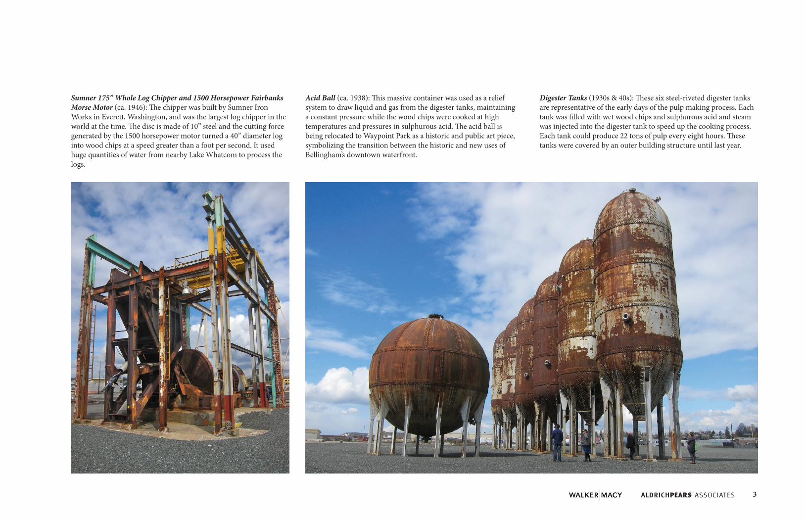
Acid Ball (ca. 1938): This massive container was used as a relief system to draw liquid and gas from the digester tanks, maintaining a constant pressure while the wood chips were cooked at high temperatures and pressures in sulphurous acid. The acid ball is being relocated to Waypoint Park as a historic and public art piece, symbolizing the transition between the historic and new uses of Bellingham’s downtown waterfront.
Digester Tanks (1930s & 40s): These six steel-riveted digester tanks are representative of the early days of the pulp making process. Each tank was filled with wet wood chips and sulphurous acid and steam was injected into the digester tank to speed up the cooking process. Each tank could produce 22 tons of pulp every eight hours. These tanks were covered by an outer building structure until last year.
4 Bellingham Waterfront District – Heritage Trail Concept Plan
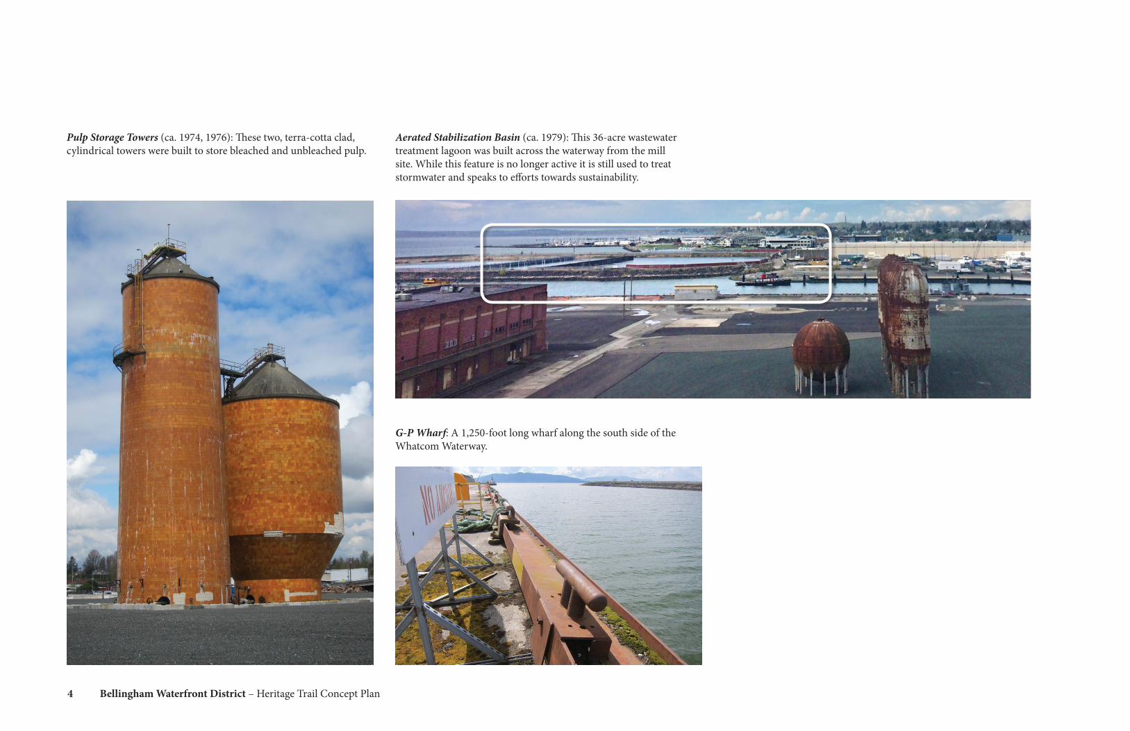
Pulp Storage Towers (ca. 1974, 1976): These two, terra-cotta clad, cylindrical towers were built to store bleached and unbleached pulp.
Aerated Stabilization Basin (ca. 1979): This 36-acre wastewater treatment lagoon was built across the waterway from the mill site. While this feature is no longer active it is still used to treat stormwater and speaks to efforts towards sustainability.
G-P Wharf: A 1,250-foot long wharf along the south side of the Whatcom Waterway.

5
Port of Bellingham Salvage Inventory Form
ID: BLP01004
Item Name: Control Panel
Building: Bleach Plant
Floor: 2nd Floor
Location Description:
On top of the poured concrete Bleach
Liquor Storage Chests located in the
northeast corner of the Bleach Plant. The
control panel faces south and is situated at
the south edge of the chest, accessible via
an elevated, grated, steel platform that also
provides access to the mix tank valves.
UPDATE (3/17/2016): Mis‐labeled as
BLP02004.
Item Description:
The control panel consists of a freestanding, b
lue enameled, vertical metal box with
rounded edges that contains gauges and cont
rols for pumps and agitators associated
with bleach liquor tanks #1, #2, and #3, lime slurry agitator and pu
mps, and other
related mechanisms. Three circular liquid level indicator gauges a
re located across top
of the panel, below which are indicator lights,
and start and stop button controls. On
the left of the panel, two metal doors provide acce
ss to a Foxboro pneumatic controller
and recorder. A blue enameled metal‐pipe electrical con
duit enters the control panel
box on its lower right side. A smaller, enameled, gray control box i
s mounted on a post
adjacent (to the right) of the blue control pan
el. It contains indicator lights and start and
stop button controls.
Condition: The leftmost circular indicator gauge is missing, as are two contr
ols. The metal box
shows indications of minor rust and corrosion
, primarily at its edges.
Function: The item is a control panel for monitoring the liquid lev
els of bleach liquor tanks #1, #2,
and #3 in the Bleach Plant and controlling the
associated agitators and pumps.
Photo Numbers: 0296‐0305
Date Recorded: 11/3/2011
Recorder Name: Hetzel, Christopher
Photo Before Salvage:
Photo In Storage:Stored In: Board Mill East end
Relocated to: Alcohol Plant Storage Unit
(Relocated) 3368‐3376
Overall Dimensions (Estimated In Inches):
Width 50 Length 14 Height 45
4/21/2016
BLP01004
Sample Inventory Form
Collection of industrial equipment and artifacts: Many smaller-scale artifacts were salvaged from the mill complex. They have been tagged and cataloged with information about each item, including their original location and use.
Interpretive opportunities for these historic resources are discussed in greater detail in the next sections of this document.
6 Bellingham Waterfront District – Heritage Trail Concept Plan
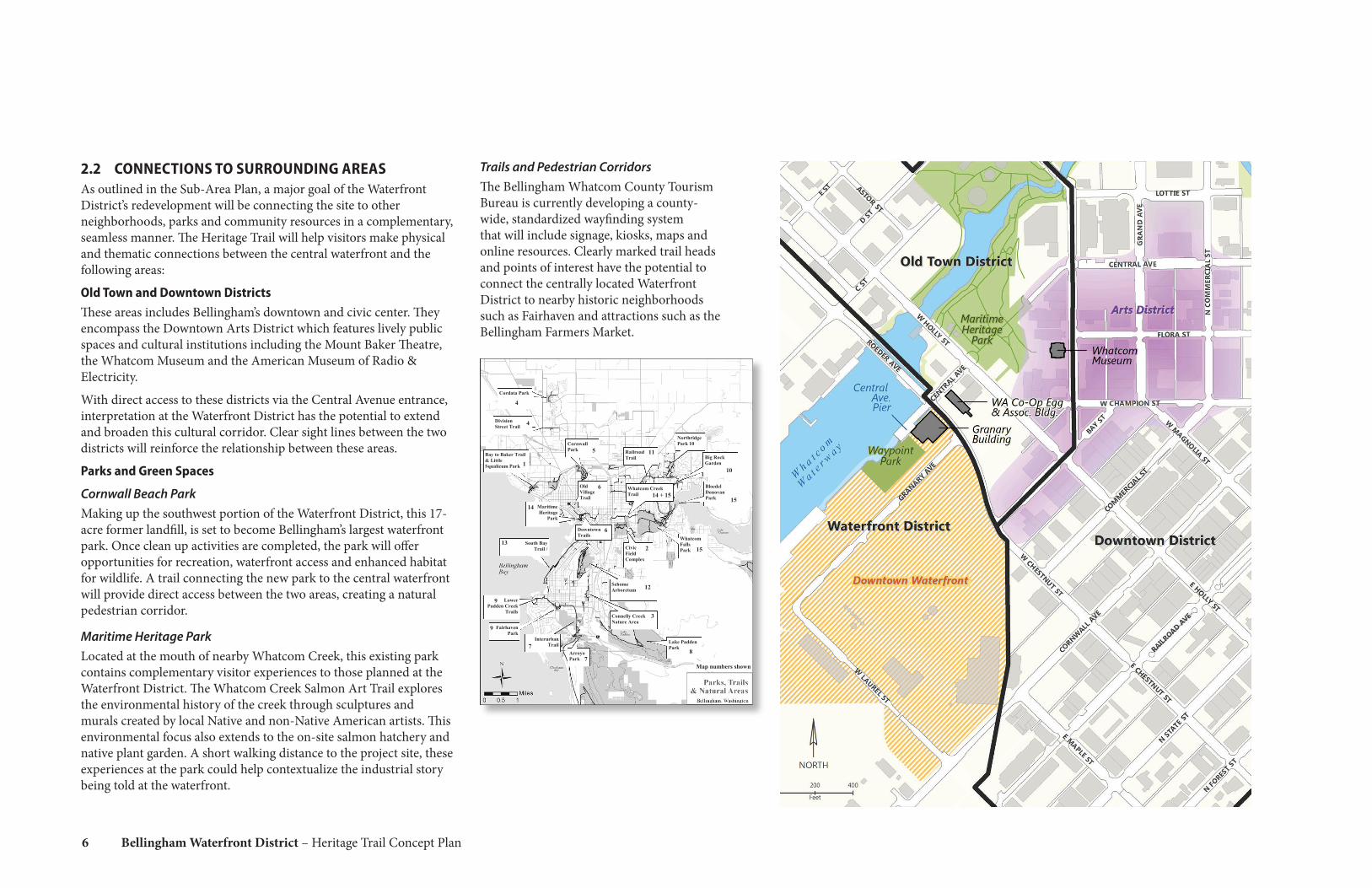
2.2 CONNECTIONS TO SURROUNDING AREASAs outlined in the Sub-Area Plan, a major goal of the Waterfront District’s redevelopment will be connecting the site to other neighborhoods, parks and community resources in a complementary, seamless manner. The Heritage Trail will help visitors make physical and thematic connections between the central waterfront and the following areas:
Old Town and Downtown Districts These areas includes Bellingham’s downtown and civic center. They encompass the Downtown Arts District which features lively public spaces and cultural institutions including the Mount Baker Theatre, the Whatcom Museum and the American Museum of Radio & Electricity.
With direct access to these districts via the Central Avenue entrance, interpretation at the Waterfront District has the potential to extend and broaden this cultural corridor. Clear sight lines between the two districts will reinforce the relationship between these areas.
Parks and Green Spaces
Cornwall Beach ParkMaking up the southwest portion of the Waterfront District, this 17-acre former landfill, is set to become Bellingham’s largest waterfront park. Once clean up activities are completed, the park will offer opportunities for recreation, waterfront access and enhanced habitat for wildlife. A trail connecting the new park to the central waterfront will provide direct access between the two areas, creating a natural pedestrian corridor.
Maritime Heritage ParkLocated at the mouth of nearby Whatcom Creek, this existing park contains complementary visitor experiences to those planned at the Waterfront District. The Whatcom Creek Salmon Art Trail explores the environmental history of the creek through sculptures and murals created by local Native and non-Native American artists. This environmental focus also extends to the on-site salmon hatchery and native plant garden. A short walking distance to the project site, these experiences at the park could help contextualize the industrial story being told at the waterfront.
Trails and Pedestrian CorridorsThe Bellingham Whatcom County Tourism Bureau is currently developing a county-wide, standardized wayfinding system that will include signage, kiosks, maps and online resources. Clearly marked trail heads and points of interest have the potential to connect the centrally located Waterfront District to nearby historic neighborhoods such as Fairhaven and attractions such as the Bellingham Farmers Market.
Bay to Baker Trail & Little Squalicum Park
Cornwall Park
Maritime Heritage
Park
Old Village Trail
Railroad Trail
Whatcom Falls Park Civic
Field Complex
Sehome Arboretum
Connelly Creek Nature Area
South Bay Trail /
Lower Padden Creek
Trails
Fairhaven Park
Lake Padden Park
Arroyo Park
Interurban Trail
Whatcom Creek Trail
Bloedel Donovan Park
Big Rock Garden
A digital version of this Park Trail Guide available at www.cob.org Trail Maps are available at the
Bellingham Parks & Recreation Main Office, 3424 Meridian Street, Bellingham, WA, 98225
3
8
12
2 13
9
9
7
7
15
14
6 14 + 15
15
11 5
1 10
Downtown Trails
6
Northridge Park 10
Cordata Park
Division Street Trail
4
4
Map numbers shown

7
2.3 AUDIENCELocalsAs part of a vital, mixed-use area, the Heritage Trail will appeal to locals from a range of backgrounds and age groups — from millennials, to families with children, to retirees. Although seemingly very different, common interests will unite some of these local visitor groups:
• Love of outdoor recreation - many locals enjoy hiking, paddling, mountain biking, sailing and other outdoor activities
• Enjoyment of local food - many locals love craft beer, farmers markets and farm-to-table restaurants
• Attraction to cultural heritage - many locals are regular attendees of the theatre, art galleries and museums
• Awareness of environmental issues - many locals share a deep interest in the environmental issues affecting their waterways, forests and communities
Out-of-Town VisitorsAs part of an emerging cultural district, the Heritage Trail will also attract out-of-town visitors. The Bellingham/Whatcom County Cultural Heritage Tourism Strategic Plan identifies a number of target audiences for cultural tourism to Bellingham. These groups will help define future visitorship to the Heritage Trail:
• Cultural heritage travelers - these visitors are generally older, more affluent and have a higher education
• Regional visitors - these visitors come to Bellingham from nearby centers including Vancouver, BC, and Seattle, WA
• Generational markets - these visitors include millennials, baby boomers and generation x-ers
In order to succeed, the design team will need to keep the interests and needs of all of these visitor groups in mind when considering thematic approaches and interpretive techniques.
2.4 SITE GOALSThe 2013 Sub-Area Plan outlines a number of environmental, economic and community goals for redevelopment at the Waterfront District. Interpretive objectives for the Heritage trail will speak to and complement these broader site goals:
• Restore the health of the land and water• Improve waterfront access• Promote a healthy and dynamic waterfront economy• Reinforce the inherent qualities of the waterfront
8 Bellingham Waterfront District – Heritage Trail Concept Plan
Bellingham Waterfront DistrictMarch 2018
Heritage Trail Concept Plan
N
3.0 Interpretive Approach
Opportunities for interpretation and associated themes and key messages are mapped onto the Waterfront District site plan, giving shape to the visitor experience.
3.1 INTERPRETIVE OBJECTIVESThe Heritage Trail and its associated historic resources and interpretive features will:
• Create a sense of “place” by highlighting the unique industrial history of the Waterfront District.
• Encourage visitors to explore and move through the site using an engaging and cohesive interpretive narrative.
• Use industrial artifacts as entry points for exploring the historical pulp and paper production process.
• Incorporate the story of the First Peoples on this land into the broader industrial narrative.
• Showcase thematic and physical connections to nearby neighborhoods and features.
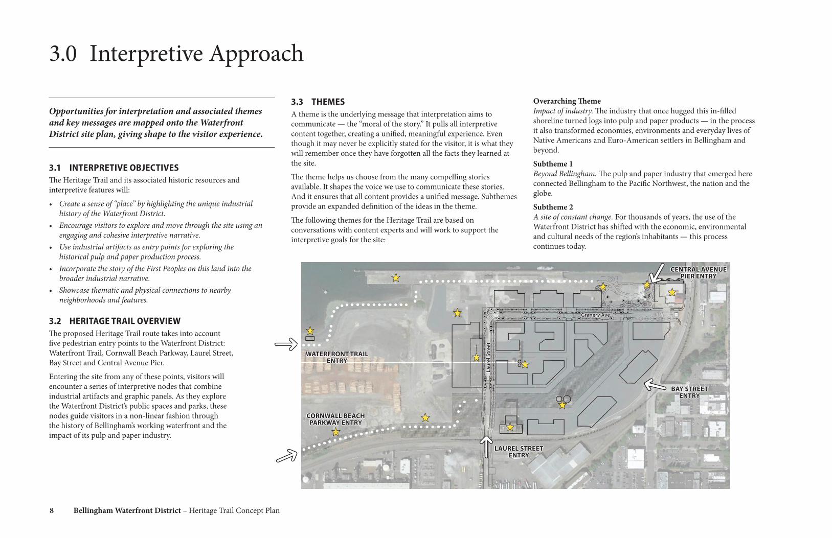
3.2 HERITAGE TRAIL OVERVIEWThe proposed Heritage Trail route takes into account five pedestrian entry points to the Waterfront District: Waterfront Trail, Cornwall Beach Parkway, Laurel Street, Bay Street and Central Avenue Pier.
Entering the site from any of these points, visitors will encounter a series of interpretive nodes that combine industrial artifacts and graphic panels. As they explore the Waterfront District’s public spaces and parks, these nodes guide visitors in a non-linear fashion through the history of Bellingham’s working waterfront and the impact of its pulp and paper industry.
3.3 THEMESA theme is the underlying message that interpretation aims to communicate — the “moral of the story.” It pulls all interpretive content together, creating a unified, meaningful experience. Even though it may never be explicitly stated for the visitor, it is what they will remember once they have forgotten all the facts they learned at the site.
The theme helps us choose from the many compelling stories available. It shapes the voice we use to communicate these stories. And it ensures that all content provides a unified message. Subthemes provide an expanded definition of the ideas in the theme.
The following themes for the Heritage Trail are based on conversations with content experts and will work to support the interpretive goals for the site:
BAY STREET ENTRY
CENTRAL AVENUE PIER ENTRY
WATERFRONT TRAIL ENTRY
CORNWALL BEACH PARKWAY ENTRY
LAUREL STREET ENTRY
Laur
el S
tree
t
Granery Ave.
Overarching Theme Impact of industry. The industry that once hugged this in-filled shoreline turned logs into pulp and paper products — in the process it also transformed economies, environments and everyday lives of Native Americans and Euro-American settlers in Bellingham and beyond.
Subtheme 1 Beyond Bellingham. The pulp and paper industry that emerged here connected Bellingham to the Pacific Northwest, the nation and the globe.
Subtheme 2 A site of constant change. For thousands of years, the use of the Waterfront District has shifted with the economic, environmental and cultural needs of the region’s inhabitants — this process continues today.

9
Bellingham Waterfront DistrictMarch 2018
Heritage Trail Concept Plan
N
Laur
el S
tree
t
Granery Ave.
3.4 THEMATIC STRUCTUREThe thematic structure maps content areas onto the site. Determining messaging for each area helps to focus visitors’ attention on one idea at a time, and allows us, to some degree, to influence how visitors relate ideas to each other.
The thematic structure proposed for the Heritage Trail draws inspiration from the site plan, and aims to use what visitors see around them to help them understand the ideas being discussed and make their own connections.
11. OTHER CONNECTIONS
Key artifact: Granary Building
Visitors learn that this site has ties to Bellingham’s agricultural history and other industrial sites in the city through interpretive graphics.
1. WELCOME
Visitors learn about the resources that attracted the first Native Americans and Euro-American settlers to this place through interpretive graphics. They use viewscopes to understand the waterfront’s relationship to nearby sites.
5. RISE OF PULP AND PAPER
Key artifact: Log Chipper
Visitors learn how a new pulp and paper industry emerged on the waterfront and became one of the most productive pulp and paper facilities in the world through interpretive graphics and artifacts.
10. END OF AN ERA
Key artifacts: Pulp Storage Towers
Visitors gain a broad overview of the history of the pulp and paper industry at the site, why it shut down and how the site has changed today through interpretive graphics and large-scale artifacts.
2. ORIGINS OF INDUSTRY
Key artifact: Acid Ball
Interpretive graphics and artifacts introduce visitors to the ways that early industrial activities first shaped this shoreline and brought more and more people and resources through the new port.
8. INTERNATIONAL IMPACT
Key artifact: Alcohol Plant
Visitors see inteprertive graphics and artifacts and learn how Bellingham’s new waterfront industry responded to global events to create profitable pulp and paper products through the 1940s and 50s.
3. ENVIRONMENTAL RENEWAL
Key artifacts: Aerated Stablization Basin, G-P Wharf
Interpretive graphics highlight the environmental impact of the pulp and paper industry on this site. A view to a former wasterwater treatment lagoon helps visitors understand the environmental cleanup efforts that began in the 1970s and that continue today.
4, 9. CLUES TO THE PAST
Key artifacts: Log Roller, misc. small artifacts
Intriguing artifacts and simple interpretation encourage visitors to explore and move through the site to learn more.
6. THE PEOPLE OF PUGET PULP
Key artifact: Board Mill Building
Interpretive graphics and artifacts introduce visitors to the human side of the pulp and paper industry using quotes from former employees to convey memories and anecdotes.
7. MAKING PUGET PULP
Key artifacts: Digester Tanks
Interpretive graphics and artifacts explore the cutting-edge technology used in the step-by-step process of turning logs into consumer products.

10 Bellingham Waterfront District – Heritage Trail Concept Plan
3.5 INTERPRETIVE CONTENT AND VISITOR EXPERIENCE MATRIX
The Interpretive Content and Visitor Experience Matrix organizes the interpretive components, presenting them in increasing levels of detail. It is a living document that will grow and change through the following design phases, at which point any empty boxes will be filled in. Throughout all phases, it helps to coordinate work done by the design team, ensuring that all parties are on the same page.
At this stage, the focus of the matrix is on describing key messages and potential content, visitor experiences and media. The focus of some areas and related content and experiences will need to be site verified at the beginning of the next phase of work and are therefore subject to change.
Matrix terms:• Content Areas: What is the main focus of the content at a
particular location? • Location: Where is the content situated on the site plan? • Key Messages: What are the main ideas that visitors will walk
away with, that will support the themes and subthemes?• Potential Content: What are the individual stories that support
the messages?• Potential Visitor Experiences: How will visitors engage with
these stories and messages? • Potential Media: What artifact or design resources will help tell
the stories?
11
Content Area Location Key Messages Potential Content Potential Visitor Experience Potential Media
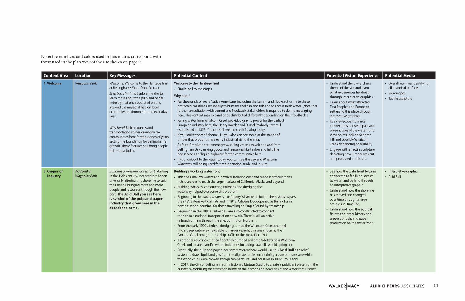
1. Welcome Waypoint Park Welcome. Welcome to the Heritage Trail at Bellingham’s Waterfront District.
Step back in time. Explore the site to learn more about the pulp and paper industry that once operated on this site and the impact it had on local economies, environments and everyday lives.
Why here? Rich resources and transportation routes drew diverse communities here for thousands of years, setting the foundation for Bellingham’s growth. These features still bring people to the area today.
Welcome to the Heritage Trail• Similar to key messages
Why here?• For thousands of years Native Americans including the Lummi and Nooksack came to these
protected coastlines seasonally to hunt for shellfish and fish and to access fresh water. [Note that further consultation with Lummi and Nooksack stakeholders is required to define messaging here. This content may expand or be distributed differently depending on their feedback.]
• Falling water from Whatcom Creek provided gravity power for the earliest European industry here, the Henry Roeder and Russel Peabody saw mill established in 1853. You can still see the creek flowing today.
• If you look towards Sehome Hill you also can see some of the stands of timber that brought these early industrialists to the area.
• As Euro-American settlement grew, sailing vessels traveled to and from Bellingham Bay carrying goods and resources like timber and fish. The bay served as a “liquid highway” for the communities here.
• If you look out to the water today, you can see the Bay and Whatcom Waterway still being used for transportation, trade and leisure.
• Understand the overarching theme of the site and learn what experiences lie ahead through interpretive graphics.
• Learn about what attracted First Peoples and European settlers to this place through interpretive graphics.
• Use viewscopes to make connections between past and present uses of the waterfront. View points include Sehome Hill and possibly Whatcom Creek depending on visibility.
• Engage with a tactile sculpture depicting how lumber was cut and processed at this site.
• Overall site map identifying all historical artifacts
• Viewscopes• Tactile sculpture
2. Origins of Industry
Acid Ball in Waypoint Park
Building a working waterfront. Starting in the 19th century, industrialists began physically altering this shoreline to suit their needs, bringing more and more people and resources through the new port. The Acid Ball you see here is symbol of the pulp and paper industry that grew here in the decades to come.
Building a working waterfront• This site’s shallow waters and physical isolation overland made it difficult for its
rich resources to reach the large markets of California, Alaska and beyond.• Building wharves, constructing railroads and dredging the
waterway helped overcome this problem. • Beginning in the 1880s wharves like Colony Wharf were built to help ships bypass
the site’s extensive tidal flats and in 1913, Citizens Dock opened as Bellingham’s new passenger terminal for those traveling on Puget Sound by steamship.
• Beginning in the 1890s, railroads were also constructed to connect the site to a national transportation network. There is still an active railroad running through the site: Burlington Northern.
• From the early 1900s, federal dredging turned the Whatcom Creek channel into a deep waterway navigable for larger vessels; this was critical as the Panama Canal brought more ship traffic to the area after 1914.
• As dredgers dug into the sea floor they dumped soil onto tideflats near Whatcom Creek and created landfill where industries including sawmills would spring up.
• Eventually, the pulp and paper industry that grew here would use this Acid Ball as a relief system to draw liquid and gas from the digester tanks, maintaining a constant pressure while the wood chips were cooked at high temperatures and pressues in sulphurous acid.
• In 2017, the City of Belingham commissioned Mutuus Studio to create a public art piece from the aritfact, symoblizing the transition between the historic and new uses of the Waterfront District.
• See how the waterfront became connected to far-flung locales by water and by land through an interpretive graphic.
• Understand how the shoreline has moved and changed over time through a large-scale visual timeline.
• Understand how the acid ball fit into the larger history and process of pulp and paper production on the waterfront.
• Interpretive graphics• Acid Ball
Note: the numbers and colors used in this matrix correspond with those used in the plan view of the site shown on page 9.

12 Bellingham Waterfront District – Heritage Trail Concept Plan
Content Area Location Key Messages Potential Content Potential Visitor Experience Potential Media
3. Environmental Renewal
TBD location along Waterfront Trail (with views of Aerated Stablization Basin and G-P Wharf)
Pulp and pollution. The pulp and paper industry that emerged here brought economic prosperity to Bellingham but also brought environmental destruction to the Whatcom Waterway. The GP Wharf you see here was part of this industry.
Shifting perspectives on the shore. Growing environmentalism of the 1970s helped to shape the Waterfront District you see today, leading to cleanup efforts and greater public access to the shore. The Aerated Stablization Basin you see across the waterway was part of this history.
Pulp and pollution• This pulp and paper industry that emerged here in the 1920s, released chemicals into
the Whatcom Waterway and foul-smelling fumes into the air. The G-P Wharf you see here was used as part of this industry - exact function/dates to be researched.
• Details of environmental impact – to be researched. • Through to the 1960s there were few environmental regulations placed on Bellingham’s
waterfront industries and little value placed on environmental stewardship. • This would begin to change in the 1970s.
• Understand the environmental impact of the pulp and paper industry on this site through interpretive graphics and artifacts.
• Interpretive graphics• G-P Wharf
Shifting perspectives on the shore• In 1972, the federal government passed the Clean Water Act, beginning
a new era of pollution control across the country. • In response, the Georgia-Pacific pulp plant built a 36-acre wastewater treatment lagoon
or Aerated Stablization Basin on the north side of the Whatcom Waterway. You can still see this lagoon across the waterway from where you are standing now.
• After G-P closed down in the 2000s, the Port of Bellingham took responsibility for cleanup efforts. These included a $35 million project that removed contamination, restored salmon habitat, rebuilt infrastructure along the shoreline.
• Starting in the 1980s, municipal projects also improved public access to the waterfront through by developing nearby Boulevard Park and Maritime Heritage Park.
• The vibrant, mixed-use waterfront you are enjoying today has its origins in these cleanup efforts and calls for public access to the shore.
• Understand the wastewater treatment lagoon through interpretive graphics and explore its historical and contemporary functions.
• Interpretive graphics• Aerated Stabilization Basin
4. Clues to the Past
Log Roller (and along Waterfront Trail)
Clues to the past. These artifacts are clues to the history of this working waterfront. Continue along this path to find out more. The Log Roller you see here is just one of these fascinating historical remnants.
Clues to the Past• Details about the artifacts on display – to be determined based on artifacts selected• The huge piece of equipment you see here is called a Log Roller and it was
used to bring logs from the millside long pond onto an inclined chain belt and system of converyors to begin the pulping process at G-P mill site.
• From here logs were moved to the debarkers and chipper.
• Engage with intriguing historic artifacts scattered along Waterfront Trail leading to Waypoint Park. Interpretation and placement encourage exploration and movement through the site to learn more.
• Interpretive graphics• Log RollerOther artifacts including:• Band mill drive wheel• Log rollers• Log conveyor• Log haul chain• Flow control valve• Brick masonry blocks• Mix tank valve handles• Gear sprockets• Chipper feeder chain• Barking nozzle• Pipe assembly (pulp storage)

13
Content Area Location Key Messages Potential Content Potential Visitor Experience Potential Media
5. Rise of Pulp and Paper
Log Chipper From timber town to pulp and paper power. As the sawmills on Bellingham’s waterfront went into decline, a new pulp and paper industry emerged on the waterfront, becoming one of the most productive pulp and paper facilities in the world. The Log Chipper you see here made this process possible.
From timber town to pulp and paper power • As the local timber supply dwindled and the Great Depression affected markets
during the 1920s and 1930s, many of Bellingham’s major sawmills closed.• One of Bellingham’s earliest pulp mills, established by Ossian Anderson in
1927, offered a new way to create value-added products from timber. • The new mill supplied the nearby Pacific Coast Paper Mills with cheap,
local pulp to produce consumer-sized rolls of tissue and paper. • In 1938, Anderson constructed an ever larger, state-of-the-art pulp
mill called Puget Sound Pulp & Timber Co. (PSP&T).• By 1949, and PSP&T had expanded its facilities several times to become
one of most productive and efficient pulp mills in the world.• Puget Sound Pulp & Timber merged with Pacific Coast Paper Mills in
1958, which in turn became part of Georgia-Pacific in 1963.• The Sumner 175” Whole Log Chipper and 1500 Horsepower Fairbanks Morse
Motor you see here were part of a this process of turning logs into pulp and paper.• Together they could turn a 40” diameter log into wood chips
at a speed greater than a foot per second. • At the time it was built around 1946, the chipper was the largest in the world.
• Understand how Bellingham’s pulp and paper industry began and expanded between the 1920s and 1960s through interpretive graphics and artifacts.
• Interpretive graphics• Log Chipper and potentially
smaller associated artifacts including:* Log conveyor* Band mill driver wheel* Chipper blade
6. The People of Puget Pulp
Board Mill Building More than a job. For the employees of Puget Sound Pulp & Timber and later Georgia-Pacific, working with pulp and paper was more than just a job – it was a source of stability, identity and pride. The Board Mill Building you see here was just one of the many places employees remember at the site.
More than a job• Employees recall the “family-like” atmosphere at PSP&T.• Many locals remember summer jobs that helped put them through college. • Other former-employees remember the friendships and mutual support the plant provided. • Many have memories of free toilet paper being given out annually to
current and former staff; it lasted most families an entire year. • Personal recollections/quotes from oral history collection at Western Washington University
– to be researched, e.g.: “It was a nice, a good place to work and good pay, and Bellingham was a good place to live so… For a working person working at a wage job that [didn’t have a] college education, it was… you couldn’t ask for anything better. – Frank Brown
• The Board Mill Building is just one of the buildings that employees came to everyday, at first to make paperboard for shoeboxes, cake boxes, etc. using recycled paper and a small amount of cellulose fiber, and after it was incorporated into the G-P facility to make parts for other machines.
• Read personal quotes and anecdotes from former Georgia-Pacific employees and understand the history of the Board Mill Building through interpretive graphics and artifacts.
• Interpretive graphics• Board Mill Building and
potentially smaller associated artifacts including:* Work place injuries sign;
safety sign from locker room
14 Bellingham Waterfront District – Heritage Trail Concept Plan
Content Area Location Key Messages Potential Content Potential Visitor Experience Potential Media
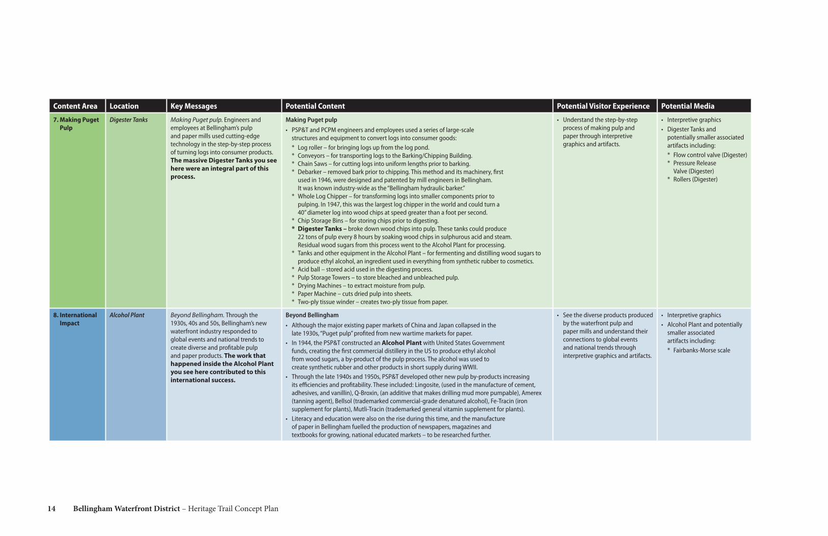
7. Making Puget Pulp
Digester Tanks Making Puget pulp. Engineers and employees at Bellingham’s pulp and paper mills used cutting-edge technology in the step-by-step process of turning logs into consumer products. The massive Digester Tanks you see here were an integral part of this process.
Making Puget pulp• PSP&T and PCPM engineers and employees used a series of large-scale
structures and equipment to convert logs into consumer goods:* Log roller – for bringing logs up from the log pond. * Conveyors – for transporting logs to the Barking/Chipping Building. * Chain Saws – for cutting logs into uniform lengths prior to barking. * Debarker – removed bark prior to chipping. This method and its machinery, first
used in 1946, were designed and patented by mill engineers in Bellingham. It was known industry-wide as the “Bellingham hydraulic barker.”
* Whole Log Chipper – for transforming logs into smaller components prior to pulping. In 1947, this was the largest log chipper in the world and could turn a 40” diameter log into wood chips at speed greater than a foot per second.
* Chip Storage Bins – for storing chips prior to digesting. * Digester Tanks – broke down wood chips into pulp. These tanks could produce
22 tons of pulp every 8 hours by soaking wood chips in sulphurous acid and steam. Residual wood sugars from this process went to the Alcohol Plant for processing.
* Tanks and other equipment in the Alcohol Plant – for fermenting and distilling wood sugars to produce ethyl alcohol, an ingredient used in everything from synthetic rubber to cosmetics.
* Acid ball – stored acid used in the digesting process. * Pulp Storage Towers – to store bleached and unbleached pulp. * Drying Machines – to extract moisture from pulp.* Paper Machine – cuts dried pulp into sheets. * Two-ply tissue winder – creates two-ply tissue from paper.
• Understand the step-by-step process of making pulp and paper through interpretive graphics and artifacts.
• Interpretive graphics• Digester Tanks and
potentially smaller associated artifacts including: * Flow control valve (Digester)* Pressure Release
Valve (Digester)* Rollers (Digester)
8. International Impact
Alcohol Plant Beyond Bellingham. Through the 1930s, 40s and 50s, Bellingham’s new waterfront industry responded to global events and national trends to create diverse and profitable pulp and paper products. The work that happened inside the Alcohol Plant you see here contributed to this international success.
Beyond Bellingham• Although the major existing paper markets of China and Japan collapsed in the
late 1930s, “Puget pulp” profited from new wartime markets for paper.• In 1944, the PSP&T constructed an Alcohol Plant with United States Government
funds, creating the first commercial distillery in the US to produce ethyl alcohol from wood sugars, a by-product of the pulp process. The alcohol was used to create synthetic rubber and other products in short supply during WWII.
• Through the late 1940s and 1950s, PSP&T developed other new pulp by-products increasing its efficiencies and profitability. These included: Lingosite, (used in the manufacture of cement, adhesives, and vanillin), Q-Broxin, (an additive that makes drilling mud more pumpable), Amerex (tanning agent), Bellsol (trademarked commercial-grade denatured alcohol), Fe-Tracin (iron supplement for plants), Mutli-Tracin (trademarked general vitamin supplement for plants).
• Literacy and education were also on the rise during this time, and the manufacture of paper in Bellingham fuelled the production of newspapers, magazines and textbooks for growing, national educated markets – to be researched further.
• See the diverse products produced by the waterfront pulp and paper mills and understand their connections to global events and national trends through interpretive graphics and artifacts.
• Interpretive graphics• Alcohol Plant and potentially
smaller associated artifacts including: * Fairbanks-Morse scale
15
Content Area Location Key Messages Potential Content Potential Visitor Experience Potential Media
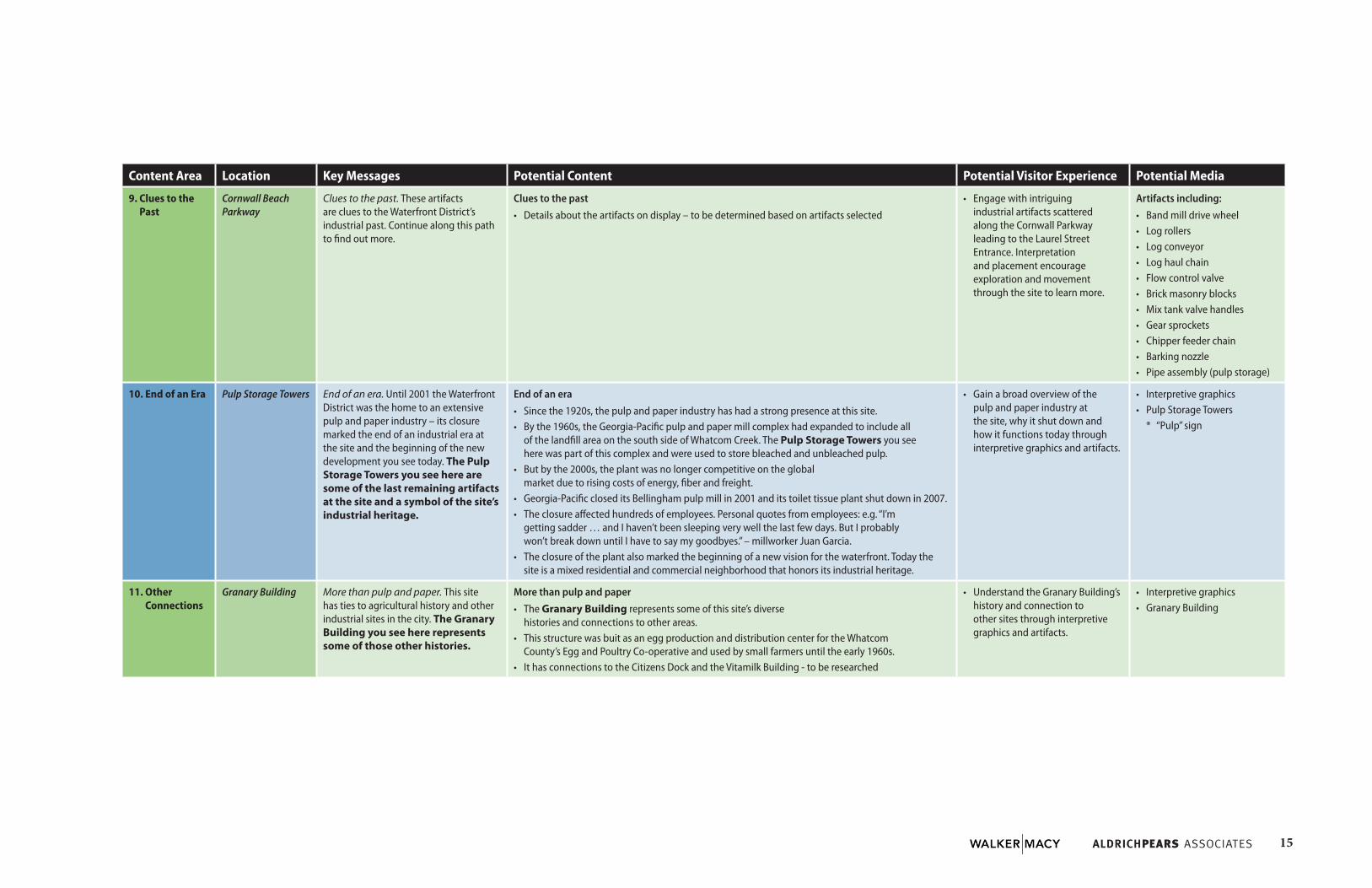
9. Clues to the Past
Cornwall Beach Parkway
Clues to the past. These artifacts are clues to the Waterfront District’s industrial past. Continue along this path to find out more.
Clues to the past• Details about the artifacts on display – to be determined based on artifacts selected
• Engage with intriguing industrial artifacts scattered along the Cornwall Parkway leading to the Laurel Street Entrance. Interpretation and placement encourage exploration and movement through the site to learn more.
Artifacts including:• Band mill drive wheel• Log rollers• Log conveyor• Log haul chain• Flow control valve• Brick masonry blocks• Mix tank valve handles• Gear sprockets• Chipper feeder chain• Barking nozzle• Pipe assembly (pulp storage)
10. End of an Era Pulp Storage Towers End of an era. Until 2001 the Waterfront District was the home to an extensive pulp and paper industry – its closure marked the end of an industrial era at the site and the beginning of the new development you see today. The Pulp Storage Towers you see here are some of the last remaining artifacts at the site and a symbol of the site’s industrial heritage.
End of an era• Since the 1920s, the pulp and paper industry has had a strong presence at this site.• By the 1960s, the Georgia-Pacific pulp and paper mill complex had expanded to include all
of the landfill area on the south side of Whatcom Creek. The Pulp Storage Towers you see here was part of this complex and were used to store bleached and unbleached pulp.
• But by the 2000s, the plant was no longer competitive on the global market due to rising costs of energy, fiber and freight.
• Georgia-Pacific closed its Bellingham pulp mill in 2001 and its toilet tissue plant shut down in 2007.• The closure affected hundreds of employees. Personal quotes from employees: e.g. “I’m
getting sadder … and I haven’t been sleeping very well the last few days. But I probably won’t break down until I have to say my goodbyes.” – millworker Juan Garcia.
• The closure of the plant also marked the beginning of a new vision for the waterfront. Today the site is a mixed residential and commercial neighborhood that honors its industrial heritage.
• Gain a broad overview of the pulp and paper industry at the site, why it shut down and how it functions today through interpretive graphics and artifacts.
• Interpretive graphics• Pulp Storage Towers
* “Pulp” sign
11. Other Connections
Granary Building More than pulp and paper. This site has ties to agricultural history and other industrial sites in the city. The Granary Building you see here represents some of those other histories.
More than pulp and paper• The Granary Building represents some of this site’s diverse
histories and connections to other areas. • This structure was buit as an egg production and distribution center for the Whatcom
County’s Egg and Poultry Co-operative and used by small farmers until the early 1960s.• It has connections to the Citizens Dock and the Vitamilk Building - to be researched
• Understand the Granary Building’s history and connection to other sites through interpretive graphics and artifacts.
• Interpretive graphics• Granary Building

16 Bellingham Waterfront District – Heritage Trail Concept Plan
4.0 Design Approach
The design approach, supported by the interpretive themes, gives structure and character to the overall visitor experience at the site.
4.1 DESIGN PARAMETERSIn general, the interpretive features described in this document:
• Depict a rich industrial history using a simple visual language, ensuring that themes and content are accessible to visitors of all ages.
• Draw vistors into this history and spark their curiosity through the site’s artifacts, both large and small.
• Encourage visitors to make connections between the Heritage Trail and the rest of the site and nearby neighborhoods; this is accomplished through viewscopes and highlighted sight lines.
• Employ a common vocabulary of industrial forms and materials while allowing for flexibility in their final design.
• Use high-quality, durable materials to ensure their longevity.
4.2 MATERIALSMaterial choices for the Heritage Trail are inspired by existing site artifacts and building details. We are proposing to convey a sense of history through the inherent colors and textures of the materials and to juxtapose them with contemporary graphic substrates for the interpretive content.
Industrial light fixture
Dimensional lumber
Cor-ten finished steel
Galvanized steelStructural steel
Engraved lumber

17
4.3 CONCEPT SKETCHESThe following sketches describe potential visitor experiences and media for several interpretive nodes.
4.3.1 (1) Welcome – Waypoint ParkVisitors entering Waypoint Park will immediately notice a graphic panel that incorporates industrial design details. Here they first encounter the overarching theme of the Heritage Trail and learn what experiences lie ahead via a map that highlights the artifacts scattered across the site.
Viewscopes attached to the steel structure help visitors understand the resources that first drew people to this unique place. They look towards the running water of Whatcom Creek and the stands of trees still visible on Sehome Hill.
Nearby, a sculpture representing various cuts of lumber hints at the first industry that sprung up on these shores.
Industrial onomatopoeia – A series of playful, imaginary words are engraved into wood panels inset into the steel structure to evoke a sense of the rhythms of the industrial processes that were associated with the site’s industries. Humm… wizz, wizz… rumble, rumble… CLICK.
Log Sculpture – This steel sculpture reveals how logs were reduced to various cuts of lumber.
Viewscopes – Rather than literally directing the viewer’s sight to objects in the environment, these viewscopes encourage people to imagine relationships between the overlaid silhouette and their immediate surroundings; they are storytelling devices that engage the imagination. The green viewscopes look towards Sehome Hill while the blue ones point towards Whatcom Creek.
Sehome Hill Whatcom Creek

18 Bellingham Waterfront District – Heritage Trail Concept Plan
4.3.2 (9) Clues to the Past - Cornwall Beach ParkwayApproaching the Waterfront District from the Cornwall Beach Parkway, visitors encounter intriguing industrial artifacts located along a pedestrian trail. Accompanied by simple interpretation, these artifacts encourage exploration and movement through the site to learn more about Bellingham’s story of pulp and paper production.
Industrial onomatopoeia – Playful, imaginary words evoke a sense of the rhythms of the industrial process that was once associated with the displayed artifact. Ka-clunk, ka-clunk, ka-clunk…
Interpretive panel – Reveals the function of the displayed artifact and can establish a visual identity for the Heritage Trail and/or Park.
Structural steel post can be adapted to support a variety of differently-shaped artifacts.

19
4.3.3 (6) The People of Puget Pulp - Board Mill BuildingAs they continue to explore the Waterfront District, visitors encounter other industrial artifacts, both large and small. Nearing the Board Mill Building, they are delighted to discover a graphic panel and small-scale artifact (to be determined) that reveal the past function of the building. Curious to learn more, they engage with the stories and quotes from former Puget Sound Pulp and Timber and Georgia-Pacific employees they see in front of them, learning why this site was so meaningful to so many people over the decades.
Interpretive panel – Reveals the function of the displayed artifact and its association with the large building or artifact in front of the visitor.

20 Bellingham Waterfront District – Heritage Trail Concept Plan
5.0 Recommendations for Interpretation
These recommendations are meant to guide the future phasing of the interpretive work at the Waterfront District and address scenarios in which it is desirable to use some, but not all, of the remaining artifacts.
5.1 PHASINGSeveral factors will shape how the interpretative elements outlined in this report will be implemented in the future. The two most important factors are:
BUDGET ALLOCATED TO INTERPRETATION – Due to budgetary concerns it may be not be possible to undertake all of the interpretive elements outlined in this document.
FUTURE DEVELOPMENT OF THE SITE – As the development of the Waterfront District evolves it may become necessary to move or remove certain artifacts. This will affect the size and scope of the Heritage Trail.
The self-contained nature of the individual interpretive nodes outlined in this report provide a good deal of flexibility as to when, or even if, they are implemented. In general, the design team recommends taking the following into account when prioritizing work for future design phases:
Initial Phases of WorkTo provide visitors with context for future interpretation it is critical to provide an introductory, welcome experience. Therefore, we recommend implementing the (1) Welcome interpretive node (see Content Matrix for more details) as part of the first phase of interpretive design work.
Likewise, (2) Origins of Industry will provide the foundational, early history of Bellingham’s waterfront and should be considered for inclusion as part of this initial phase of work. Associated with the repurposed Acid Ball artifact, it is also likely to draw attention from large numbers of visitors.
Finally, because environmental stewardship is at the heart of Bellingham’s waterfront history we also recommend implementing (3) Environmental Renewal as part of this initial stage of work.
Subsequent PhasesSubsequent phases should include interpretive nodes at the site’s remaining large-scale artifacts and buildings. These elements form the anchor points of the Heritage Trail and will inspire curiosity in visitors, begging the questions: “What is this?” and “What was it used for?” These include:
(4) Clues to the Past - Log Roller artifact
(5) Rise of Pulp and Paper - Log Chipper artifact
(6) The People of Puget Pulp - Board Mill Building
(7) Making Puget Pulp - Digester Tank artifacts
(8) International Impact - Alcohol Plant
(10) End of an Era - Pulp Storage Tower artifacts
Final PhasesThe last phases of work should include the following as complementary but not integral elements of the Heritage Trail narrative:
(9) Clues to the Past - Small-scale artifacts
(11) Other Connections - Granary Building
5.2 OPTIONS FOR INTEGRATION OF ADDITIONAL ARTIFACTS
In March 2014, the Port of Bellingham engaged ICF International to prepare a salvage/reuse plan for numerous additional industrial artifacts salvaged from the Georgia Pacific Pulp and Paper Mill Property. The concepts on the following pages advance the City’s vision to integrate industrial artifacts within the built environment of the Waterfront District.
These artifacts should link to and complement the numerous interpretive nodes outlined in previous sections, and for that reason, additional art within the district is intended to be playful, whimsical and complementary to the industrial fabric of the district. A future art plan should begin to identify opportunities and potential themes for temporary and site specific installations at a range of budgets. The goal of the art plan would be to help activate the Waterfront District, instill curiosity and provide elements of surprise, as well as to provide opportunities for younger and less established artists to make contributions to the public landscape.
This effort recommends the Bellingham Arts Commission be engaged in any further development or implementation of this plan in order for it to align it with the Waterfront District Master Plan and the overall City public artwork goals.

21
ARTIFACT ARTIFACTPOTENTAIL RE-USE POTENTAIL RE-USE
Band Mill Drive Wheel
Flow Control Valve
Control Panel
Sculpture
Children’s Play Feature
Bar, Hotel, Restaurant
Log Conveyor
Log Chipper
Roller
Seating
Art in the Landscape
Kayak Slide


800-1281 West Georgia Street Vancouver, BC V6G 2T3 Phone: 604-669-7044
200-111 SW Oak Street Portland, OR 97204 Phone: 503-228-3122