Embed Size (px)
Citation preview

Page 1 of 142
Lovelace Neighbourhood Plan - 2019-2034
A PLAN FOR RIPLEY, OCKHAM AND WISLEY
6 September 2018

Page 2 of 142
CONTENTS
1. --------- INTRODUCTION 8
1.1. Neighbourhood Plans 8
1.2. Why Lovelace? 8
1.3. Legislative Backing 9
1.4. The Plan Document 9
1.5. The Future 9
2. --------- LOVELACE PROFILE 11
2.1. Housing 13
2.2. Environment 15
2.2.1 Rural Environment and Open Spaces 15
2.2.2 Natural Habitats 16
2.2.3 Flooding 16
2.2.4 Air Quality and Traffic 17
2.3. Infrastructure 19
2.3.1 Utilities 19
2.3.2 High Speed Broadband 19
2.3.3 Public Transport 19
2.3.4 Cycling and Walking 19
2.3.5 Parking 20
2.3.6 Community Facilities and Activities 20
2.3.7 Healthcare 22
2.3.8 Schools in Lovelace 22
2.4. Business and Employment 23
2.4.1 Local Employment Characteristics 23
2.4.2 Working from Home 24
3. --------- CONSTRAINTS AND CHALLENGES 25
3.1. Green Belt 25
3.2. Introduction - The Perfect Storm 25
3.2.1 Already Approved 25
3.2.2 Pending 25
3.2.3 In the Emerging GBC 2017 LP 26
3.3. RHS Wisley Expansion 27
3.4. The Drift Golf Club 27
Page 3 of 142
3.5. M25 / A3 – Junction 10 Improvements 29
3.6. Proposed Sites - GBC 2017 Emerging Local Plan 30
3.6.1 Three Farms Meadows (Site A35, GBC 2017 LP) 31
3.6.2 Garlicks Arch (Site 43, GBC 2017 LP) 33
3.6.3 Other Housing Sites 33
3.6.4 Burnt Common Slip Roads 34
3.7. Summary 34
4. --------- LOVELACE VISION AND OBJECTIVES 35
4.1. Housing 35
4.2. Environment 35
4.3. Infrastructure 35
4.4. Business and Employment 36
5. --------- LOVELACE OBJECTIVES AND POLICIES 37
6. --------- HOUSING POLICIES 40
96.1 Introduction 40
6.2 Housing Sites 42
6.3 Housing for All 44
6.4 Design and Density 47
7.1 Introduction 50
7.2 Protecting Local Green Spaces (LGS) 52
7.3 Biodiversity and Natural Habitats 55
7.4 Flooding 58
7.5 Light Pollution 60
7.6 Air Quality and Traffic 62
8. INFRASTRUCTURE 67
8.1 Introduction 67
8.3 Public Transport and Green Travel 70
8.4 Cycling and Walking 72
8.5 Parking 74
8.6 Community Facilities 78
8.7 Healthcare and Educational Provision 79
Page 4 of 142
9. BUSINESS AND EMPLOYMENT 81
9.1 Introduction 81
9.2 Preserve and Develop Business & Employment 83
9.3 Rural and Agricultural 86
APPENDIX 1. MAPS 87
APPENDIX 2 SUMMARIES OF SURVEYS 92
2.1 The 2015 Summer Survey Summary 92
2.1.1 What's Good, What's Bad? 92
2.1.2 What Is Missing? 92
2.1.3 What Else Is Needed? 93
2.1.4 What Sort of Place Should Ripley Be? 93
2.1.5 Other Issues 93
2.2 Summer 2015 Survey Analysis 95
2.3 The Lovelace Housing Development Survey 2016 97
2.4 Ockham Housing Survey 98
2.5 The 016 Summer Survey 98
2.6 The 2016 Facilities Survey 99
2.7 The 2016 Business and Employment Survey 100
2.8 The 2018 Summer Survey 101
3.1 Population Growth and Households - 2011 and 2016 103
3.2 Housing Stock 103
3.3 Lovelace Property Purchase and Rental Prices 104
3.4 Additions to Housing Stock in Ripley over Last 5 Years 105
3.5 Ripley Village Businesses Commercial Conversions 105
3.6 Three Farms Meadows/Wisley Airfield – Land and Building 107
APPENDIX 4. ENVIRONMENT 110
2.1 Air Quality 110
4.2 Lovelace Local Green Spaces 113
4.2.1 Ripley Local Green Spaces 113
4.2.2 Ockham Green Spaces 114
4.2.3 Wisley Green Spaces 115
4.3 Local Views 115
Page 5 of 142
4.4. Biodiversity – Ockham and Wisley Commons 123
APPENDIX 5 INFRASTRUCTURE 126
1.1 Public Transport – Three Farms Meadows 126
APPENDIX 6 GLOSSARY 127
REFERENCES 136

Page 6 of 142
Map 1 - Lovelace – Green Belt and Surrounding Conurbations
Map 2 - Environmental Designated Areas
Map 3 - Woodland and Grassland
Map 4 - SSSI Impact Zones
Map 5 - Local Green Spaces
Map 6 - Flood Risk
Map 7 - Bus Stops and Schools
Map 8 - Public Rights of Way
Map 9 - Footpaths
Map 10 - Road Noise

Page 7 of 142
Acronyms
AONB Area of Outstanding Natural Beauty
BOA Biodiversity Opportunity Area
BOATs Byways Open to All Traffic
CAA Conservation Area Appraisal
CIL Community Infrastructure Levy
CPRE Council for the Protection of Rural England
DEFRA Department for Environment Food and Rural Affairs
GA Garlicks Arch
GBC Guildford Borough Council
GBC 2003 LP Guildford Borough Council 2003 Local Plan
GBC 2017 LP Guildford Borough Council 2017 Local Plan
HE Highways England
LAA Land Availability Assessment
LAQMA Local Air Quality Management Area
LGS Local Green Spaces
LNP Lovelace Neighbourhood Plan
LNPG Lovelace Neighbourhood Plan Group
LNR Local Nature Reserves
LRN Local Roads Network
NPPF National Planning Policy Framework
REH Rural Exception Homes
RHS Royal Horticultural Society
RSPB Royal Society for the Protection of Birds
SLGA (p33) L.H.5 ??????????
SCC Surrey County Council
SCREF Surrey Countryside and Rural Enterprise Forum
SNCI Site of Nature Conservation Interest
SPA Special Protection Area
SRN Strategic Roads Network
SSSI Site of Special Scientific Interest
SWT Surrey Wildlife Trust
THBSPA Thames Heath Basin Special Protection Area (also referred t as SPA)
TFM Three Farms Meadows (former Wisley airfield)

Page 8 of 142
1. INTRODUCTION
1.1. Neighbourhood Plans
Lovelace comprises the villages of Ripley, Ockham and Wisley. To understand why Lovelace have
chosen to have a Neighbourhood Plan, it is helpful to know a little of the process of deciding
planning applications and land use in England. The highest level is the countrywide Town and
Country Planning Act 1990, from which Councils prepare a Development Plan for their county. In
Surrey, Local boroughs, e.g. Guildford Borough Council (GBC), then prepare a Local Plan (LP) for
their district. All plans cover housing needs and infrastructure requirements and Local Plans
allocate sustainable sites in the borough for housing, both strategic and non-strategic.
The Localism Act 2011 introduced a further planning level, the Neighbourhood Plan (NP), designed
to help Councils, e.g. Guildford Borough Council, to make planning decisions informed by more
local level policies shaped by the communities most likely to be affected by them. The Lovelace
Neighbourhood Plan (LNP) must be in general conformity with the strategic policies of the adopted
GBC 2003 Local Plan (GBC 2003 LP), but it is sensible also to give regard to the GBC Emerging 2017
Local Plan (GBC 2017 LP) which was submitted for examination in December 2017.
All Plans must conform to the National Planning Policy Framework (NPPF) guidelines, which offer
guidance on suitability of locations, and other matters.
1.2. Why Lovelace?
In 2014 Ripley Parish Council resolved to take advantage of this new opportunity by preparing a
Neighbourhood Plan for the area. After consultation with adjacent parishes, it was decided that the
most appropriate area for such a plan would be the Lovelace Ward of Guildford Borough, which
includes the villages and civil parishes of Ripley, Ockham and Wisley.
As all three civil parishes will be similarly affected by major development proposals, major road
network changes and other factors over the next decade or so, it is sensible for the Lovelace
Neighbourhood Plan to cover the whole Ward.
The first step was Guildford Borough Council designating Lovelace as a Neighbourhood Plan Area in
February 2015. Ripley and Ockham Parish Councils agreed to a working party of volunteers setting
up the Lovelace Neighbourhood Plan Group (LNPG) with the aim of providing a draft
neighbourhood plan for consideration by the people of Lovelace Ward.
The makeup of the LNPG is defined in the LNPG Constitution, which is available on our website at
http://lovelaceplan.co.uk/get-involved/the-constitution-of-the-group.

Page 9 of 142
1.3. Legislative Backing
The Lovelace Neighbourhood Plan (LNP) has been drawn up in accordance with the Town and
Country Planning Act 1990, the National Planning Policy Framework (NPPF), the Planning Policy
Guidance, (PPG), the Planning and Compulsory Purchase Act 2004, the Localism Act 2011 and the
Neighbourhood Planning Regulations 2012 (amended 2016). It is in general conformity with the
strategic policies in the adopted Guildford Borough Council 2003 Local Plan and has regard to the
Emerging GBC 2017 Local Plan. Once accepted, the LNP will be in force for 15 years, i.e. between
2019-2034, unless superseded by a later version, and will inform all planning decisions in the area.
The regulations emphasise the importance of the policies contained within it accurately reflecting
the views of the stakeholders in the area, including the residents, local businesses, community
groups and frequent visitors. The LNPG has carried out public and targeted surveys which have
formed the objectives and policies of this plan. (Appendix 2).
1.4. The Plan Document
The purpose of the LNP is to:
1. Define how and where development takes place during the next fifteen years, whilst
accepting that it cannot interfere with the selection process of major strategic local sites.
2. Provide guidance for developers and planning authorities as to the character, density and
other parameters which all future developments must meet.
The most important part of our plan is the list of policies contained in Section 6 and set out in
detail in the following pages. Each of these covers a different aspect of the development
framework for the area. It is these policies, and their supporting documents, against which
planning applications will be assessed. (Each policy is highlighted in a box). The background against
which the policies have been drafted is summarised in Lovelace Profile (section 3), which is further
supported by evidence contained in the Appendices. When considering applications, decision
makers should take into account the whole policy, including sections referred to by the policies in
the boxes.
1.5. The Future
The LNP is prepared for the Lovelace residents and stakeholders to read and comment onduring a
six-week Public Consultation, known as Regulation 14 Consultation. The Plan will be amended
accordingly and submitted for independent examination. The Examiner may require amendments
and, when made, a Public Referendum will be held for Lovelace to accept, or reject, the LNP. Once
accepted, the GBC decision makers must take into consideration the policies within this Plan when
considering planning applications.

Page 10 of 142
The audience for this document is: The independent Examiner, Guildford Borough Council planning
decision makers, Ripley and Ockham Parish Councils, local residents and stakeholders.

Page 11 of 142
2. LOVELACE PROFILE
Lovelace is located within the Green countryside that surround the conurbations of Woking to the
west, Weybridge to the north west, Cobham to the north east and Guildford to the south. The
whole of Lovelace is within the London Metropolitan Green Belt, which prevents the merging of
these conurbations.
Lovelace borders other Neighbourhood Plan areas, i.e. Send, West Clandon, East Clandon, West
Horsley, East Horsley and Effingham in Guildford Borough; Woking town, Pyrford, Byfleet and West
Byfleet in Woking Borough and Cobham in Elmbridge Borough.
The Lovelace Neighbourhood Plan area comprises three civil parishes, collectively known as Lovelace
Ward, represented by one councillor at Guildford Borough Council. Lovelace Ward forms part of the
Horsleys electoral division of Surrey County Council, along with East Clandon, East and West Horsley,
and Effingham parishes, and lies in the north-western corner of Mole Valley parliamentary
constituency. Lovelace is bisected by the London to Portsmouth A3 and the M25 on its northern
side.
Lovelace Boundary
The three villages all have Conservation Areas and very different characteristics and history. They
each have some built up areas, but also a great deal of moderate to good agricultural land (Grade 3a
and 3b under the Agricultural land classifications), producing a range of high yield arable crops and
grass for the grazing of cattle.

Page 12 of 142
The area also has environmentally designated areas, i.e. Thames Basin Heaths Special Protection
Area (TBHSPA/SPA), Sites of Special Scientific Interest (SSSIs) and Sites of Nature Conservation
Interest (SNCIs).
Ripley has much the largest population (approx. 80%) within the Lovelace Ward and is a thriving
community located on the former London to Portsmouth road, bypassed since the 1970s by the new
A3. The Ripley Conservation Area covers the central area of Ripley village and contains most of its
57 Grade II and one Grade I listed buildings, together with buildings of varied architectural style
and of extensive historical interest, a range of housing types and styles and a variety of shops and
small businesses.
It also boasts one of the largest village greens in England (67 acres) and a cricket club and clubhouse
dating from the mid-eighteenth century.
Ockham is a diverse, low-density, area which has never been a traditional village comprising a
single settlement. It is, and always has been, a community of small hamlets and dwellings scattered
over 2000 acres with just 187 households (2011 CENSUS). Ockham has been in existence since the
bronze age and is a rural area made up of eight small hamlets including Elm Corner, Hatchford End,
Martyr's Green, Mays Green, Bridge End, Church Ockham, Alms Heath and Ockham Mill, and has a
rural, picturesque, medieval and historic character.
Ockham has a number of listed buildings; 29 are Grade II listed and Ockham is notable for the Grade
I listed 12th century All Saints’ Church. It has two Conservation Areas and large swathes of common
land in the TBHSPA. It is the home of the Chatley Heath Semaphore Tower (grade II listed), which is
open to the public and has views to the next Semaphore tower south towards Guildford, and
overlooks Three Farms Meadows. Ockham is the birthplace of William of Ockham, the originator of
Occam’s Razor, and home of Ada Lovelace, Lord Byron's daughter, known for her work on Charles
Babbage's proposed mechanical general-purpose computer, the Analytical Engine.
Wisley is an ancient farming hamlet, occupied since the iron age, which changed in character after
the Royal Horticultural Society (RHS) opened their first garden there in the early 20th century, now
their flagship garden. The Conservation Area in Wisley comprises two listed buildings, the Grade I
church and the adjacent Grade II Elizabethan farmhouse,
Arts and Crafts style buildings are featured at the RHS with the main building listed Grade II and the
Garden itself listed as Grade II* Historic Parks and Gardens. Most of the current inhabitants of
Wisley work for the RHS, or comprise families of their employees.
The RHS Wisley borders Wisley Common and the TBHSPA and much of the northern part of Wisley is
flood plain.
The Lovelace Neighbourhood Plan aims to conserve the character of the three villages by a
combination of reliance on its Green Belt status, its conservation areas and the development
management policies contained in this document.

Page 13 of 142
2.1. Housing
Lovelace has wide variety of housing stock which has seen a significant change over the last half
century from a broad mix of social housing, tied housing, privately-owned and rented small
cottages, farmhouses and large family homes to a predominantly privately-owned stock of housing
of above average market value. There is now little social or affordable housing. The results of
surveys carried out during the preparation of this plan have shown that there is significant need for
genuinely affordable homes of all sizes and types to provide smaller new homes for first-time
buyers, smaller family homes and properties for downsizing by an ageing population, plus a lesser
need for additional market value properties.
The Lovelace villages offer a rare combination of visual appeal, rural aspect, village communities and
proximity to London, reflected in its high house prices - approaching double those in the south of
England generally, except in London. This means house building is very profitable and brings
tremendous pressure from developers for permission to build in the area, which is in danger of
losing its unique identity as a result.
In the last four years Lovelace has provided new housing at a rate which is proportionately seven
times the average level for the borough as a whole. New houses, per head, built between 2012 and
2017 (for example) equates to: 3.8% for Lovelace, 0.5% for Guildford, 0.4% for the rest of the
borough.
Ripley
Ripley is a parish of 910 homes (2016) with the largest population in Lovelace, approximately 2,000,
(80%). There have been a number of new infill developments in the village in recent years and there
are a number of additional planning applications being put forward. The village is a mainly a mix of
small terraced and semi-detached properties and has a number of properties dating back to the 15th
century.

Page 14 of 142
An aerial view of Ripley
The Green Belt and Countryside Study commissioned by Guildford Borough Council in 20131 found
that Ripley does not have ‘an open character that contributes to the openness of the Green Belt’ in
accordance with the National Planning Policy Framework (NPPF), para 86. The emerging GBC 2017
LP intends to inset (take out of the Green Belt) the village, facilitating the approval of further
housing projects within the settlement boundary. GBC recently published a Conservation Area
Character Appraisal for Ripley2.
Ockham
Ockham’s housing number in 2016 was 187 properties and a population of approximately 430,
spread across the eight hamlets of Ockham parish. Most of the properties comprise single-family
dwellings and there are an exceptionally high proportion of listed buildings. The village has a
distinctive rural and peaceful character.
Ockham has a brownfield site where approximately 27 dwellings are proposed, proportionate to
current resident numbers. However, a major challenge to the rural character of Ockham is the
zoning in GBC’s 2017 LP of a new town of some 2,000+ dwellings at Three Farms Meadows, (Section
3.6), a site roughly in the centre of the necklace of eight hamlets, situated on a ridge overlooking the
surrounding area and facing the AONB. The outline planning application includes five-storey blocks
of flats, which would change the landscape and character of the village. This is a controversial site
and was the subject of a five-week Inquiry in September-October 2017, brought about by the site
owners, which upheld GBC’s Planning Committee decision to refuse planning permission. However,
GBC had included this site as a site to be removed from the Green Belt in their 2017 draft Local Plan.
.
Wisley
The housing situation here is not typical for Lovelace, or even Guildford as a whole. This community
is unusual in that 90 of the 111 properties in the village belong to the RHS, with a total population of
168 (March 2018). The RHS has recently taken a strategic decision to refurbish and rent a number of
its properties to non-employees and has a longer-term aspiration to build additional properties to
rent, in order to allow Wisley to develop into a more genuine mixed community, with village
facilities and a life beyond the RHS.
There is no current evidence of specific housing needs but the RHS’s recent experience in renting
out properties formerly let to employees suggests that the village is attractive to incoming residents
and could be successfully expanded, subject to infrastructure availability and regard to the
constraints of falling within the Special Protection Area (SPA) and Flood Zones 2 and 3.b.
1 Invalid source specified. 2 (Guildford Borough Council - Ripley Conservation Area Appraisal, 2017)

Page 15 of 142
2.2. Environment
2.2.1 Rural Environment and Open Spaces
Lovelace is currently 100% Metropolitan Green Belt, is predominantly rural and includes the
TBHSPA, Sites of Special Scientific Interest (SSSIs), Sites of Nature Conservation Interest (SNCIs),
Local Nature Reserves (LNRs) and ancient woodlands. (Appendix 1, Map 2). These areas make up
approximately 11% of Lovelace and include Ockham and Wisley Commons, Three Farms Meadows,
Ripley Green, Papercourt Lake and the River Wey and Wey Navigation. Much of Lovelace is
farmland.
The land is relatively flat in nature, with exceptions being the elevated ex-runway on the former
Wisley airfield at Three Farms Meadows, (which has views to the AONB to the south) and Battleston
Hill at the RHS Wisley.
To the eastern boundary is the River Wey and the Wey Navigation, a significant historic feature
owned and managed by the National Trust.
Ripley
Ripley has one of the largest village greens in England (approximately 67 acres) and has a cricket
club and clubhouse dating from the mid-eighteenth century. It is also home to the football club and
is the site of the monthly Farmers Market, the famous Ripley Bonfire, annual fetes, etc.
The Green is in the centre of Ripley village, extending from Newark Lane to the boundary with
Ockham Parish and virtually to the Royal Horticultural Society at Wisley. Now designated as an SNCI,
it survived the Enclosure Acts of the early 1800s and remains as common land managed by Ripley
Parish Council on behalf of Surrey County Council.
Papercourt Lake in Newark Lane is monitored by Natural England and, together with two areas
alongside the River Wey, is designated SSSI. The three areas of open water at Papercourt Lake are all
former gravel workings, and have become artificial lakes, the largest used by a sailing club and
fishermen. The large meadow to the west of Papercourt Lock, the only one of its type in Surrey,
supports a variety of plant life, some quite rare.
Ockham
Ockham Common comprises approximately 335 acres of Surrey heath land and is designated
TBHSPA, SSSI and LRN. Ockham Common has two car parks, a cafe and many footpaths and
bridleways, including those accessing Wisley Common via a bridge over the A3, and footpaths
crossing the old airfield. Three Farms Meadows, the land around the former airfield, is designated
SNCI. Ockham Common has access to Chatley Heath and its 1822 Semaphore Tower.
Ancient woodlands are situated at Hatchford End and alongside the A3, both In Ockham, and there
is open farmland throughout the ward.

Page 16 of 142
Wisley
Wisley Common, also part of the TBHSPA, comprises some 350 acres of heathland. There is
adequate parking and the commons are used by walkers and riders. The commons in Wisley and
Ockham are managed by Surrey Wildlife Trust, a charity. The RHS gardens at Wisley, approximately
175 acres, may be considered an open space although entry is not free. It does have fenced
footpaths running through it, as well as the River Wey as a border. Much of Wisley is flood plain.
As Lovelace is wholly situated in the Green Belt it is considered important to conserve the open
spaces and views from each of the villages and maintain the feeling of rural openness.
2.2.2 Natural Habitats
The farmland, commons and numerous open green spaces alongside the settlement areas, provide
for a wealth of natural wildlife and habitats. Throughout Lovelace and surrounding areas there are
well-established mature trees and ancient hedgerows. Rights of Way are bordered by ancient
hedgerows and lines of trees providing important wildlife corridors and stepping-stones linking
woodlands and fields, creating a network which sustains the ward’s biodiversity.
Ockham Common is designated LNR and Ripley opened a new nature reserve and pond in Spring
2017, on the formerly derelict land adjoining the churchyard, which abuts the current village
settlement boundary.
Most roads are unlit which encourages nocturnal wildlife.
There is active management of the TBHSPA areas using cattle to graze and the removal of scrub /
young trees.
2.2.3 Flooding
Flooding is an issue in parts of the ward, particularly surface flooding. The River Wey and various
other watercourses pass through Lovelace and a large area within Wisley is flood plain. There have
been numerous local flood events in the recent past, some caused by the management of river flows
(using the weir system on the Wey Navigation) and some by inadequate and antiquated drainage
systems throughout Lovelace. There was substantial disruptive, long-term, flooding throughout the
ward in the winter of 2013/14, as was the case in much of the country.

Page 17 of 142
Flooding in Newark Lane
The Ripley sewers are ‘combined sewers’ carrying both surface water and untreated sewage.
Sewage overflows occur in Ripley at the sewage works and Ockham suffers from regular flooding of
its roads by a combination of surface water and untreated sewage, a problem which Thames Water
has been aware of for over 10 years. Sewage in an open ditch was reported on 2nd May 2018, and
the various authorities are deciding who should take care of the problem.
The complex network of ancient drainage ditches throughout this part of Surrey has been poorly
maintained in recent years so that much of the man-made drainage in the area is in danger of being
permanently lost. A programme of drains clearance has been instituted in some areas, such as
Pyrford (adjoining Wisley and Ripley), and by the RHS and The Wisley Golf Club (partly in Lovelace)
with positive results, but much of the network remains severely obstructed by silting, tree roots and
vegetation.
2.2.4 Air Quality and Traffic
Traffic flows on the Strategic Road Network (SRN) in Surrey are far higher than those experienced
nationally. In 2008 traffic flows on A-roads in Surrey, including both trunk roads which form part of
the SRN, and county-maintained roads which do not, averaged 21,400 vehicles per day, 64% higher
than the national average of 13,079 vehicles per day., .
Lovelace is bisected by the A3 and contains A3/M25 junction 10 (Wisley Interchange), which runs
approximately along its northern boundary. There is a strong relationship between traffic conditions
on the A3 and those on the Local Roads Network (LRN). Motorists see Ripley as a route to by-pass
the severe, high volume, rush hour congestion on the A3 and the M25.
Narrow rural lanes are used as rat-runs to and from Woking and surrounding villages particularly at
rush hours. In Ripley village centre, this causes major problems on either side of the Newark Lane

Page 18 of 142
and Rose Lane junctions in the centre of the village. Ripley Is often used as a alternative route when
there are problems on the A3.
Newark Lane in the centre of Ripley, used by buses, HGVs and traffic heading for Woking
The A3 Ockham and Burnt Common roundabouts, at either end of Lovelace, are both two-way
junctions. Traffic from Ockham travelling south drives through Ripley to access the southbound A3
at Burnt Common. Traffic from Send and Sendmarsh travelling north uses Ripley to access the
northbound A3 from the Ockham roundabout. Traffic from Ockham, Effingham, Horsley, etc.,
travelling to Woking or Byfleet drives through Ripley or Wisley.
Every Lovelace public survey highlighted traffic volumes as the number one concern for residents of
the ward, followed by traffic speed and parking problems. (Appendix 2).
The feedback was so consistent that the LNPG and Ripley and Ockham Parish Councils
commissioned air quality surveys for Ripley and Ockham, both of which found air pollution levels to
be up to 50% more than legal limits.
Environmentally, the A3/M25 interchange is a major source of pollution for biodiversity in general
and plant/animal life in particular. The recent air quality surveys carried out in the TBHSPA within
the ward for the 2017 appeal for Three Farm Meadows also showed a number of sites clearly in
excess of acceptable levels (Appendix 4.1).
The changes proposed for the A3/M25 junction 10 improvements, the expansion of the RHS facilities
to substantially increase visitor numbers and two proposed significant housing developments at

Page 19 of 142
Three Farms Meadows and Garlicks Arch will add substantially to LRN and SRN traffic and air
pollution levels.
2.3. Infrastructure
2.3.1 Utilities
Thames Water has confirmed that there is unlikely to be an adequate clean water supply in this
area to accommodate the level of development proposed by the GBC 2017 LP. Gas is available in
parts of Lovelace, but not in some rural area.
2.3.2 High Speed Broadband
Broadband access in Ripley is relatively good, but in Wisley and most of Ockham it is extremely
poor. This is a problem for those who work from home and for private users.
2.3.3 Public Transport
Lovelace is badly served by public transport; it has no rail links. Woking is the most popular station
with fast services to London Waterloo, followed by West Byfleet, Horsley and Effingham Junction.
Guildford station is not popular, mainly because of access via the problematic Guildford gyratory
system. All stations are reached by car and many people are dropped off, to be picked up later in the
day.
The bus services are poor, or non-existent. The 715 Guildford and Kingston is approximately hourly,
and ends by 8pm. The Woking buses (462/3) run twice a day and finish late afternoon.
Ripley village is served by the Guildford-Kingston route, whereas Wisley and Ockham have no direct
bus service but can access the above from the A3.
For the foreseeable future, the main form of transport to and from work, schools and village or town
facilities will remain the car.
2.3.4 Cycling and Walking
Cycling has been popular in and to the area since the late 19th century, with a noteable increase in
‘serious’ cycling since the 2012 Olympic cycling route passed through Ripley with much of the same
route now being used for the annual Ride London event. Most of these ‘serious’ l cyclists are visitors
to the area and their presence, especially at weekends, causes local traffic disruption as most of the
LRN comprises very narrow lanes.
Apart from the 'serious' cyclists, local cyclists are rarely seen as the rural roads linking the villages
are very narrow, unlit, generally have no pavements but do have traffic travelling at high speeds.
The Dept of Transport ‘Manual for Streets’ (MfS) itself acknowledges “high speeds or high volumes

Page 20 of 142
of traffic tend to discourage cycling”3. Although the MfS prefers cycle lanes to be on the
carriageways, cycling within Lovelace could be encouraged by the provision of safe cycle paths with
lighting on the verges between three villages. New cycle paths could generally run alongside
Lovelace’s unlit roads, and although lighting would provide a sense of security at night, it would
need to comply with Policy E.EN4, Light Pollution and not significantly disturb wildlife.
The RHS would like to see improved walking and cycling routes to the Gardens, in particular the
change of Muddy Lane, Wisley, to a bridleway, to encourage cycle travel to and from Byfleet and
Woking. The RHS would also support improvements to the A3 cycle route between Lovelace and
Guildford.
Off-road, Lovelace has an extensive network of Public Rights of Way that include Footpaths,
Bridleways and Byways Open to All Traffic (BOATs). In addition, there are a number of Permissive
Footpaths and Bridleways in the ward.
2.3.5 Parking
People are attracted to Lovelace by the quality of life and environment and tourists and visitors
enjoy Ripley village, the RHS Gardens, and the surrounding local countryside.
The rural areas have visitor car parks at Boulder Mere, Ockham Common, Chatley Heath and Wisley
Common, which are well used by walkers, etc. SCC have, however, recently introduced parking
charges, the consequences of which for visitor numbers are as yet unknown. Visitors to Ripley
Green generally use the free car parks on the Green.
Ockham and Wisley have few parking problems but this is a very important issue for Ripley village
residents, businesses and visitors. A combination of inadequate parking facilities, together with
inappropriate parking, creates safety hazards on a daily basis.
The RHS will require further parking for additional visitor traffic after their expansion, but this will be
accommodated within the RHS grounds.
The GBC 2017 LP proposes new housing which could add approximately 6,000 people in or adjacent
to Lovelace, who will want to use local shops, pubs and restaurants, most of which are located in
and around Ripley village. This will add to the severe parking problems currently experienced.
2.3.6 Community Facilities and Activities
Ripley
Ripley has many active clubs and societies, including the local history society, cricket, bowling, sailing
and football clubs, an over-sixties club, The Shed Youth Club, a scout troop, the Royal British Legion,
the Fuchsia Group, Ripley & District Horticultural Society, Probus Club and Rotary Club.
3 (Dept. for Transport, 2007, pp. 71, point 6.45)

Page 21 of 142
The village hosts main events each year, including the huge annual bonfire, the Summer Event,
Ripley Rocks music festival, the monthly Farmers Market and the annual Ride London event, which
closes Ripley High Street for some hours. Combined, these events attract thousands of local and
non-local people, providing direct benefits.
Ripley Village Hall is the main venue for indoor events, and utilised for amateur dramatics, antiques
fairs, motor cycle clubs, musical performances, talks, yoga and keep-fit classes, toddler play groups
and the Curzon Country Cinema. However, the Village Hall, owned by a charity, is in poor condition
overall and funds are currently being raised to provide a replacement. The area around the Village
Hall has been included as a Local Green Space, but it is understood that the hall may move location
within its grounds without losing recreational space.
The outdoor events are held on Ripley Green or other locations around the village.
The local History Museum, next to the Village Hall, Ripley
The Parish Council owns allotments at the edge of the village which are over-subscribed.
The Parish church in Ripley is St Mary Magdalene (C of E) a 12th century foundation. The nearest
Roman Catholic churches are St Edward’s, Sutton Place and St Dunstan’s in Woking and the nearest
mosque is also in Woking.
Send & Ripley Matters (a printed quarterly booklet), the Ripley Grapevine (online), Ripley Parish
Council’s website and the Ripley Village websites (www.ripleyvillage.co.uk and
www.discoverripley.co.uk) all provide information about local activities and events or promote
activities in Ripley.
The Ripley Grapevine is a free, privately run, email ‘noticeboard’ for those choosing to subscribe.
Ockham
Ockham has a Cricket Club, with football facilities. Its pavilion and the Parish Rooms are used for
village social events. It has an active Ockham & Hatchford Residents Association. The Friends of All

Page 22 of 142
Saints’ Church take an interest in the historic affairs of the village. The Black Swan Public House is
situated on the boundary of the village with Cobham, at the junction of Old Lane and Ockham Lane
and is more of a gastro-pub since a major refurbishment. The former Hautboy Inn was converted to
residential flats around 8 years ago.
Ockham has the ancient All Saints’ church (C of E) built between the 12th and 15th centuries and
restored and extended in the late 19th century.
Wisley
Within Wisley there is a pavilion and cricket pitch which are available for hire to the local
community. The RHS is providing allotments for people within the village and the wider ward.
Although there are currently no shops or other amenities within the village the garden centre, shop
and coffee shop at RHS Wisley are accessible without entering the Gardens. The Anchor pub at
Pyrford Lock, is only some 500 yards beyond the end of the village.
Wisley has a small Norman church known only as Wisley Church (C of E).
2.3.7 Healthcare
The Lovelace Ward has no NHS GP surgeries but has one private doctor in Ripley. Residents use NHS
surgeries at The Villages Medical Centre, in nearby Send, the Horsley Medical Practice, or further
afield.
The nearest NHS hospitals are the Royal Surrey County Hospital in Guildford (six miles), Ashford St
Peter’s in Chertsey (nine Miles) and Woking Community Hospital with a 12-hour Walk-in Centre (six
miles).
There is one dentist in Ripley offering private and NHS services. Woking Community Hospital offers
emergency dental services.
There is one small care home, Riversway, in Newark Lane and numerous others in the immediate
area.
2.3.8 Schools in Lovelace
Lovelace had one state primary school, Ripley Primary School, (a Church of England Voluntary
Controlled Primary School working in partnership with the Diocese of Guildford (DoG) and Surrey
Local Authority (SLA) for children aged 4-11 and one private school, Ripley Court, for children aged
3-13.
Ripley Primary School spent 11 terms without a permanent head teacher. In May 2017 a letter was
sent by the current temporary head teacher suggesting parents might like to consider other schools
for the children. That head teacher has public denied writing the letter, only sending it out to
parents. In September 2017 the number of children at the school had dropped from 144 to 70. The

Page 23 of 142
SCC and DoG decided the school would close because a) it had received a poor Ofsted review,
Ofsted declared the school lacked “senior strategic management” and b) falling numbers.
Ripley Primary School closed in July 2018. The nearest State primary schools are in Send (4 miles
away) and Pyrford (a similar distance). Neither is within walking distance of Ripley village.
On 30th August 2018 GBC agreed that Ripley Primary School become an Asset of Community Value
(ACV). The ‘Friends of Ripley Primary School’ have taken legal advice and are considering a Judicial
Review.
Both schools have a nursery and pre-school, either alongside or adjoining the school, or as part of
the school itself. Ockham has a Montessori nursery, Wisley does not have any such facilities. The
Ripley Pre-School will remain in its location adjoining the main Ripley Primary School building until
July 2019.
There are 38 other primary schools within five miles (as the crow flies) from Ripley.
The nearest state secondary schools are located outside the ward in Burpham, Sheerwater,
Kingfield, Effingham and Guildford. In total there are 17 secondary schools within five miles (as the
crow flies) from Ripley.
2.4. Business and Employment
2.4.1 Local Employment Characteristics
Lovelace has an active business community split between Ripley village centre, Wisley village and
the rural areas of Ripley, Wisley and Ockham.
The commercial centre is Ripley village and rural businesses include farms, smaller agricultural,
horticultural and equine-related activities such as livery stables, nurseries, kennels, etc., and a few
small light industrial areas.
Ripley is a character village in a conservation area, situated on the old A3 linking London and
Portsmouth. Its early commercial activities included the provision of accommodation and social
facilities for sailors and travellers and from the 1950s antique shops, pubs and service retailers
dominated.
Today it is a thriving village, the compact High Street containing almost all the commercial activity,
attracting tourists, diners and shoppers and providing local employment. The numerous social
events throughout the year which bring visitors into the village provide a direct benefit to traders, as
does internet marketing.
Permitted development for change of use from commercial to residential dwellings is reducing the
number of business premises, thereby decreasing employment. It is unknown nowadays for
residential properties to be converted to business premises, whereas the opposite is common.
Page 24 of 142
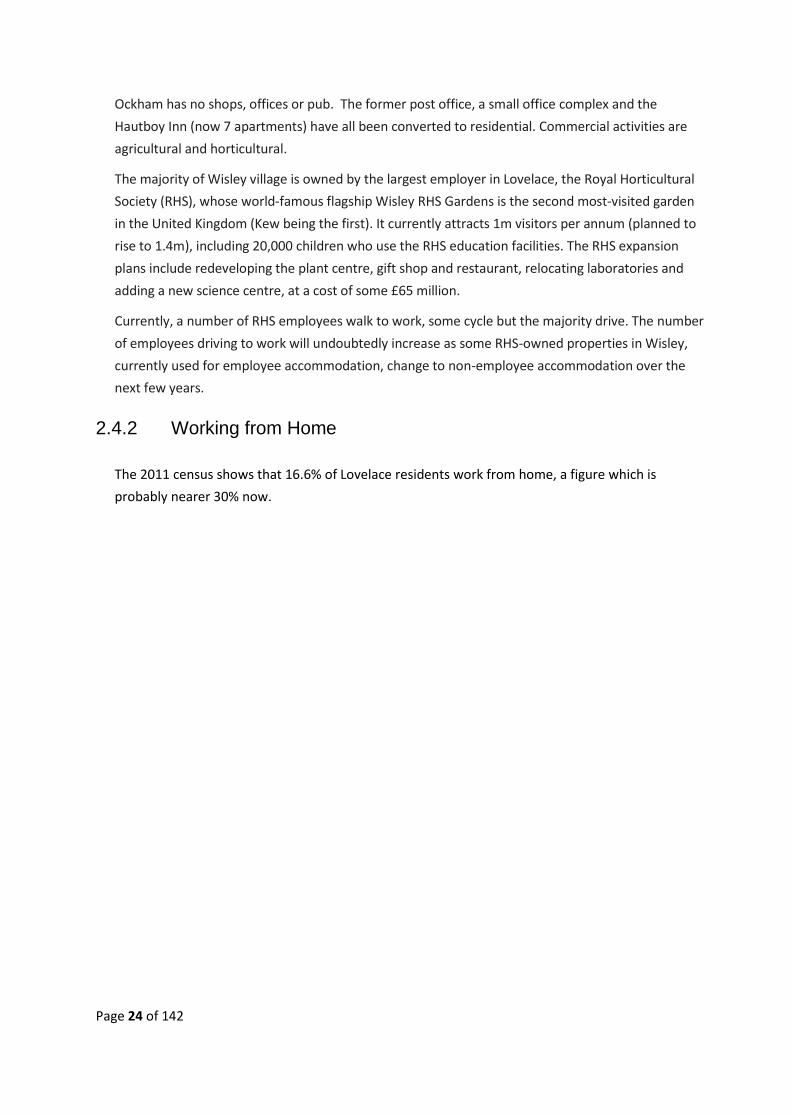
Ockham has no shops, offices or pub. The former post office, a small office complex and the
Hautboy Inn (now 7 apartments) have all been converted to residential. Commercial activities are
agricultural and horticultural.
The majority of Wisley village is owned by the largest employer in Lovelace, the Royal Horticultural
Society (RHS), whose world-famous flagship Wisley RHS Gardens is the second most-visited garden
in the United Kingdom (Kew being the first). It currently attracts 1m visitors per annum (planned to
rise to 1.4m), including 20,000 children who use the RHS education facilities. The RHS expansion
plans include redeveloping the plant centre, gift shop and restaurant, relocating laboratories and
adding a new science centre, at a cost of some £65 million.
Currently, a number of RHS employees walk to work, some cycle but the majority drive. The number
of employees driving to work will undoubtedly increase as some RHS-owned properties in Wisley,
currently used for employee accommodation, change to non-employee accommodation over the
next few years.
2.4.2 Working from Home
The 2011 census shows that 16.6% of Lovelace residents work from home, a figure which is
probably nearer 30% now.

Page 25 of 142
3. CONSTRAINTS AND CHALLENGES
3.1. Green Belt
The Metropolitan Green Belt was established in 1956 to protect the green space around London, but
has nonetheless been progressively eaten into by local councils, planners and developers driven by
housing demand and the potential for financial gain. Having squeezed the Green Belt as tightly as
possible within the M25, attention is now turning to the areas just outside the motorway, including
Lovelace. The area is particularly interesting to developers due to its proximity to the A3/M25, to
both Heathrow and Gatwick, but primarily to London.
The Green Belt provisions have been sufficient to limit development outside the settlement
boundaries. Guildford Borough Council's 2017 Local Plan seeks to remove two large areas in
Lovelace overriding the Green Belt protections using the powers of a Local Plan. If approved,
development will be allowed in these areas.
3.2. Introduction - The Perfect Storm
It is understood that strategic development sites are not within the remit of a Local Neighbourhood
Plan “unless there is a specific local need to address them at Neighbourhood Plan level”. We believe
that this applies to the Lovelace NP.
To provide a balanced view of the area, and evidence of why our policies have been created, this
section looks at the unique major constraints and challenges facing Lovelace over the next decade,
with particular regard to severely increased traffic and air pollution.
Lovelace faces ‘the perfect storm’ during the next 10 years due to a number of major projects either
already approved or proposed and all of which will be happening at more or less the same time.
Some are from government organisations such as Highways England (HE), SCC and GBC, others are
private initiatives. These will impact all 2,200 Lovelace inhabitants and any newcomers.
3.2.1 Already Approved
• RHS expansion.
Cost: £60 million. Start date: 2017. Finish date: 2021. Target date for increase to 1.4m
annual visitors: 2024-25. (RHS Wisley)
• The Drift Golf Club. Approved redevelopment.
Cost: unknown. Start date: TBC. Finish date: unknown. (The Drift Golf Club)
3.2.2 Pending
• M25/A3 - Junction 10 Wisley Interchange improvements (subject to final consultation).

Page 26 of 142
Cost: £180 - £250 million. Start date: 2020-21. Finish date: To be confirmed, probably 2-3
years. (Highways England)
3.2.3 In the Emerging GBC 2017 LP
• Three Farm Meadows/former Wisley Airfield. (Site A35)
Proposed 2,100 new homes. Commencement date: Likely 2020 if site agreed for housing.
Completion date: 2032 approx. (Wisley Investment Properties Ltd/GBC)
• Garlicks Arch. (SITE A43)
Proposed 400 new homes. Commencement Date: Likely 2019. Finish Date: 2021 (TBC).
• Garlicks Arch / Burnt Common New A3 slip roads. (SITE A43A)
Commencement date: Likely 2019. Finish Date: 2 years approx. after commencement.
(GBC/Wisley Investment Properties Ltd)
If all of these developments go ahead Lovelace will face 10 – 15 years of considerable traffic and
infrastructure disruption together with the long-term permanent changes which will come from a
quadrupling of the present population and major increase in vehicular traffic.

Page 27 of 142
3.3. RHS Wisley Expansion4
Due to the RHS plan to expand their visitor numbers from the current 1m to 1.4 m by 2024-25, with
a subsequent huge increase in traffic on local roads. This will not affect parking in the villages, other
than RHS visitors visiting the villages, but it will involve increased use at the Ockham roundabout and
additional traffic on the LRN and SRN.
3.4. The Drift Golf Club5
The approved redevelopment of the Drift Golf Club course in Ockham is for a golf teaching academy,
new maintenance building and irrigation lake. The work is expected to take nine months and
involves the transport onto site of some 87,805 tonnes of inert waste materials along various local
routes and 8,000 individual HGV movements along local roads, but work has not yet commenced.6
This movement of the inert waste materials required Surrey County Council (SCC) approval.7.
4 ( Guildford Borough Council - RHS Planning Application No 16/P/01080, 2016) 5 (Guildford Borough Council - The Drift Planning Application No. 14/P/01718, 2014) 6 (GBC Planning Applications - The Drift Routing Plan Map, pg 5, 2014) 7 (Surrey County Council - Planning No. 2014/0150, 2016)

Page 28 of 142

Page 29 of 142
3.5. M25 / A3 – Junction 10 Improvements
Highways England (HE) plan to make significant changes at the M25/A3 Junction 10 to reduce
congestion at the junction and improve access to the RHS Wisley Gardens. This will include adding
an extra sliproad onto the M25 from the A3 and an extra lane between the Ockham roundabout and
Painshill Roundabout, north of the M25.8 Two options were selected for public consultation in 2017
and in December HE decided their preferred option. HE believe these improvements will save an
average of 2-5 minutes on travel time at the junction and reduce personal injury accidents by an
average of 14 per year. HE acknowledge there will be changes to levels of air and noise pollution and
loss of habitat for rare species due to SPA/SSSI land being commandeered for this purpose.
Currently, access to the RHS from all directions is generally via the Ockham roundabout. Traffic from
the north and east access the gardens from the M25/southbound A3 leave the A3 at the Ockham
roundabout, then double back onto the northbound A3 to access Wisley Lane and the RHS. Traffic
from the south and west travels through Ripley or Ockham to access the Ockham roundabout. The
exit for the majority of RHS/Wisley village traffic is via Wisley Lane and the slip road onto the A3
northbound. (The alternative is the narrow, windy, road to West Byfleet, generally used by locals).
HE plan to close the entry from Wisley Lane onto the A3 and create a new two-way slip road from
the Ockham roundabout for entering and exiting Wisley Lane. This will be a two-way road from the
Ockham roundabout, alongside the east of the A3, with a bridge over the A3 to Wisley Lane, as
8 (Highways England - M25 Junction 10 / A3 Wisley Interchange, 2018)

Page 30 of 142
shown in the HE map below. The RHS are discussing other options with HE, including south-facing
slips at Ockham roundabout.
HE stated at the 2017 public consultations that under their new scheme for RHS visitors traffic
coming from, and returning to, the south / west will be directed to the M25/A3 Wisley Interchange,
and then travel south on the A3. This will add 6.5km to each journey for southbound traffic. No
evidence has been provided that visitors with local knowledge or using satnavs will follow this longer
route instead of leaving the A3 at Burnt Common and driving through Ripley to reach the new access
road at the Ockham roundabout. For the same reason they will be likely to return to the south /
westbound A3 via Ripley and the Burnt Common access.
HE stated at their 2017 public consultations that they have not taken the 2,000+ houses at Three
Farm Meadows into consideration as there is currently no planning permission for this site.
3.6. Proposed Sites - GBC 2017 Emerging Local Plan
A Strategic Housing Market Assessment (SHMA) for Guildford Borough was commissioned by the
Borough Council as a foundation for the housing element of the new draft Local Plan and addressed
the need for new dwellings at 654 per annum across the borough over a 15 year period,
considerably higher than the figure for neighbouring boroughs of similar size. The SHMA draws upon
population projections produced by the ONS and household projections produced by the

Page 31 of 142
Department for Communities and Local Government as a baseline, and includes an uplift as required
by the National Planning Policy Framework.
This has been a controversial subject throughout the borough and considered by some not to be a
verifiable or transparent calculation. The spreadsheet used to process the data and produce the
figures has been released, but the formulae behind the spreadsheet have not, as the company who
produced the data consider this proprietary data.
Much of the southern half of Guildford borough is designated an Area of Outstanding Natural
Beauty (AONB) and developments of more than 10 homes are prohibited except in certain
circumstances. Therefore, larger housing developments are proposed around Guildford town and in
a "ribbon" to the north east of the borough, alongside the A3 (see diagram below), rather than using
brownfield sites, including surface car parks, in and around Guildford and encouraging small
developments throughout the borough and the AONB.
Figure 1: Strategic Sites GBC Draft Local Plan
3.6.1 Three Farms Meadows (Site A35, GBC 2017 LP)9
Three Farms Meadows, (TFM) also known as the former Wisley Airfield is wholly in Lovelace,
situated in the Green Belt and surrounded by the eight hamlets of Ockham.
9 (Guildford Borough Council - Policy A35, Infrastructure, point 6, 2018)

Page 32 of 142
The 114 ha site has 17 ha of brownfield, of which 9 ha are the former hangars area and the
remaining 8 ha is the former runway. The remainder of the site is high quality farmland which is
actively farmed. Situated alongside the SPA and SSSI, TFM is itself an SNCI.
In the GBC 2014 draft Local Plan it was proposed to inset and designate the site strategic, for the
development of a new town of 2,000+ homes. The Regulation 18 public consultation received more
than 20,000 objections. The planning application was unanimously rejected by the GBC Planning
Committee in March 2016 on grounds including inappropriate development of the Green Belt,
potential for environmental harm and the impact on the SRNs (A3/M25)10. The GBC 2017 revised LP
has expanded the site.
Situated mainly on a ridge, TFM is the only site in the emerging GBC 2017 LP totally surrounded by
Green Belt and not adjacent to any urban development. The only other similar site, at Normandy
and Flexford, which proposed 1,100 homes and with a railway station in one corner and bus services
alongside, has been removed from the GBC 2017 LP due to its Green Belt status.
TFM has no railway stations within walking distance and one cycle lane alongside the A3 leading to
Ripley Village. The local roads to all adjacent villages are windy and narrow with no footpaths or
lighting and the nearest village is Ripley, the centre of which is approximately 1.5km from the closest
point of the site. The owners had proposed providing bus services to local railway stations but the
GBC 2017 LP shows the service to Woking, with its fast, non-stop, trains to London, has been
removed.
The local average is two cars per household and it is inevitable that car usage would predominate
with an additional 4,000 cars from this site. Construction traffic over the next 10 or more years must
also be taken into account. Cars travelling to Woking station will continue to drive through the
centre of Ripley Village, or the narrow Wisley Lane, as at present.
Both Ockham, near the A3, and Ripley village currently have proven air quality issues but no solution
has been offered to mitigate the extra air pollution caused by the traffic associated with this
development and its impact on Ripley.
Described as a ‘village’ by the developers and GBC, according to
government documents the distinction between a village and a
town is not based on the population size, or the number of
homes, but the density. The density of this site would be well
within the range categorised as a ‘town’.
The site would be developed over a period of at least 10 years;
but could be much longer with the considerable infrastructure
work required.
A 5-week Public Inquiry held in September-October 2017
resulted in a decision on 13th June 2018 to uphold the GBC
10 (Guildford Borough Council - 15/P/00012 Refusal , 2016)

Page 33 of 142
planning refusal on this site.11 This was cited harm to the Green Belt
(paras 20.32-20.38, and 22.1-22.2); severe impact on the SRN (paras
20.52-20.59 and 22.3); (para 23.5), and sustainability (para 23.9).
On 5th July 2018, the final day of the GBC Local Plan Examination (Reg.
22), the Inspector declared the GBC LP “sound”. This appears to
approve the removal of the former Wisley Airfield from the Green Belt
and the final report will be available later in 2018.12
3.6.2 Garlicks Arch (Site 43, GBC 2017 LP) 13
Garlicks Arch is at the southern end of Ripley Village, partly within Lovelace and partly within
neighbouring Send. The GBC 2017 LP proposes the area for a development of a total of 400 dwellings
with an adjacent new 7,000+ sq. m industrial site at Burnt Common roundabout.14 The timetable for
these developments to start is also likely to be during the next 2/3 years, if approved.
3.6.3 Other Housing Sites
GBC have included other sites in their Land Availability Assessment (LAA) such as Send Prison, at the
far end of Lovelace, close to Clandon, but have only included major sites included in the GBC 2017
LP. There are other brownfield sites in Lovelace which will inevitably become available in time.
In addition, there are several local developments currently going through planning applications. Six
possible homes at the former Smith Pearman site in the centre of Ripley and Tyrrells brownfield site
in Ockham for 26 homes, along with the 26 new homes on a greenfield site already approved in
Ripley village.
The RHS Wisley would like to have part of their land inset and build new homes to deliver a
revitalised, sustainable village. Given its commitment to sustainable development the Lovelace Plan
supports this proposal. However, much of Wisley village settlement falls within 400 metres of the
SPA, which prohibits new residential development, and any new homes would need to meet
national policy on Green Belt and be limited by being in flood zones 2 and 3. Insetting Wisley Village
is not included in the GBC 2017 LP.
Should the GBC 2017 LP be adopted in its current form, the local housing need within Lovelace
would be met many times over and Lovelace would be delivering a disproportionate number of
homes compared to the rest of the borough.
11 (Planning Inspectorate - 18-06-13 DL+IR Wisley Airfield 3159894.pdf, 2018) 12 (Guildford Borough Council - 2017 Local Plan Examination, 2018) 13 (Guildford Borough Council - Policy A43, Garlicks Arch, 2018) 14 (Guildford Borough Council - Policy A58, 2018)

Page 34 of 142
3.6.4 Burnt Common Slip Roads15
Burnt Common is a two-way junction to the south of Ripley, in neighbouring Send. The GBC 2017 LP
proposes two new on/off slip roads on the A3 at Garlicks Arch/Burnt Common to create a full four-
way junction. At present this is subject to HE approval, but it has been put forward by Wisley
Properties Investments Ltd as a traffic amelioration scheme relating to the TFM development. This
would mean TFM traffic, as well as RHS traffic, travelling through Ripley High Street to Burnt
Common. It is unlikely this could commence whilst the A3/M25 improvements were under
construction, just two miles north on the A3, so this may commence around 2023 and take up to 2
years.
A further GBC strategic site is Gosden Hill Farm, just one mile to the south of Burnt Common where
1,700 dwellings are proposed and access to the A3 is also planned to be via the Burnt Common
junction.
3.7. Summary
The six major developments above will affect Lovelace residents over the period of this plan. The
most important adverse affect would be the increase in construction and future residential traffic
exacerbating the effect on air quality in residential areas
15 (Guildford Borough Council - Policy A43a, 2018)

Page 35 of 142
4. LOVELACE VISION AND OBJECTIVES
The primary objective of the Lovelace Neighbourhood Plan is to contribute to the achievement of
sustainable development within the borough by providing suitable housing in sustainable locations
for all sectors of the local community, whilst respecting the local character and built-up density of
the residential and rural landscape.
The vision is for the essential character of the area to be conserved and enhanced, in terms of the
physical environment, local facilities and employment whilst seeking to overcome the challenges
which extensive new housing will bring to the Ward.
The objectives below summarise the views of the residents and stakeholders in the area obtained
through the public surveys and consultations.
4.1. Housing
• Provide at least a proportional share of the housing numbers required by the Guildford
SHMA, with the probability of that figure being exceeded by a reasonable amount
• Ensure development occurs in sustainable locations, avoiding overdevelopment
• Ensure all developments provide a mix of housing size required for all local needs
• Provide more affordable housing, especially for people with local connections
• Provide housing density and design appropriate to the prevailing styles in the area
• Ensure adequate off-street parking is included in all new housing applications
4.2. Environment
• Conserve the Green Belt and essential rural character of the area
• Protect Local Green Spaces of community value and local views
• Retain and increase the local biodiversity assets
• Require developments to have lowest possible carbon footprint
• Require potential flood issues to be addressed prior to development
• Require light pollution to be addressed and minimized
• Ensure footpaths and public rights of way are kept clear and well maintained
4.3. Infrastructure
• Require infrastructure to be in place before development occupation
• Require major developments to provide good public transport facilities to local railway
stations and towns
• Ensure safe and well-lit cycle lanes and paved footpaths are provided to local facilities
• Mitigate against increased traffic in areas where air quality pollution levels are already
excessive

Page 36 of 142
• Support measures to provide adequate public parking in suitable locations
• Support the increase in provision of community facilities, particularly those which provide
for the young, less abled, and older members of the community
• Support new developments providing community infrastructure including shops, community
halls, open spaces, sports facilities and social infrastructure that supports healthy lifestyles
and community cohesion.
• Support good broadband facilities to all new developments
4.4. Business and Employment
• Retain commercial premises in Ripley and expand retail facilities, particularly in the village
centre
• Ensure existing commercial premises do not lose their current off-street parking facilities
• Support new and existing business where it does not have an adverse effect on residents,
(i.e. no significant extra traffic, HGVs, anti-social delivery times, on-street parking
requirements, noise, fumes, litter, etc.)
• Support change of use which provides employment if not adversely affecting neighbouring
residents
• Support rural industries and businesses, particularly if countryside related, which does not
adversely affect neighbouring residents.
Page 37 of 142
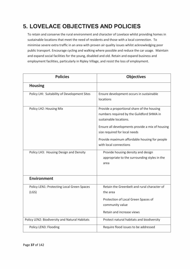
5. LOVELACE OBJECTIVES AND POLICIES
To retain and conserve the rural environment and character of Lovelace whilst providing homes in
sustainable locations that meet the need of residents and those with a local connection. To
minimise severe extra traffic in an area with proven air quality issues whilst acknowledging poor
public transport. Encourage cycling and walking where possible and reduce the car usage. Maintain
and expand social facilities for the young, disabled and old. Retain and expand business and
employment facilities, particularly in Ripley Village, and resist the loss of employment.
Policies Objectives
Housing
Policy LHI: Suitability of Development Sites
Ensure development occurs in sustainable
locations
Policy LH2: Housing Mix
Provide a proportional share of the housing
numbers required by the Guildford SHMA in
sustainable locations.
Ensure all developments provide a mix of housing
size required for local needs
Provide maximum affordable housing for people
with local connections
Policy LH3: Housing Design and Density
Provide housing density and design
appropriate to the surrounding styles in the
area
Environment
Policy LEN1: Protecting Local Green Spaces
(LGS)
Retain the Greenbelt and rural character of
the area
Protection of Local Green Spaces of
community value
Retain and increase views
Policy LEN2: Biodiversity and Natural Habitats Protect natural habitats and biodiversity
Policy LEN3: Flooding Require flood issues to be addressed

Page 38 of 142
Policy LEN4: Light Pollution Require light pollution to be addressed and
minimized
Policy LEN5: Air Quality and Traffic Related
Pollution
Air quality.
Traffic through Ripley and LRN
Infrastructure and Facilities
Policy LI1: Infrastructure
Require all infrastructure to be in place before
development occupation
Policy LI2: Public Transport and Green Travel
Require large developments to provide good
public transport facilities to major railway
stations and towns
Policy LI3: Cycle Lanes and Public Footpaths
Ensure safe and well-lit cycle lanes and
footpaths are provided to nearby facilities
Policy LI4: Parking
Support measures to provide adequate public
parking
Ensure retail premises do not lose their
current off-street parking facilities
Policy LI5: Provision of Community Facilities
Support the increase in provision of
community facilities, particularly those which
provide for the young, less abled, and older
members of the community.
Support developments that provide
community infrastructure including shops,
community halls, open spaces, sports facilities
and infrastructure that supports healthy
lifestyles and community cohesion.
Policy LI6: Healthcare and Education
Consider new healthcare, sports and
education facilities on a case by case basis
Support good broadband facilities to all new
developments
Business and Employment

Page 39 of 142
Policy LBE1: Change of Use from Commercial
to Non-Commercial
Retain and extend commercial activities in
Ripley Village, particularly in the Village
centre.
Support new business where it does not have
an adverse effect on residents, i.e. significant
extra traffic, HGVs, anti-social delivery times,
on-street parking requirements, noise, fumes,
litter.
Support change of use or new builds which
provide employment if not affecting
neighbouring residents
Policy LBE2: Agricultural and Horticultural
Land Use
Support rural commerce, particularly if
countryside related, if unlikely to cause noise
or disturbance to neighbouring residents

Page 40 of 142
6. HOUSING POLICIES
96.1 Introduction
This is the most important section of policies, addressing the requirement for suitable, sustainable
sites for infill and small (up to 10 homes) developments and the two large sites proposed at either
end of Lovelace, Three Farms Meadows (TFM), and Garlicks Arch (GA). It addresses the need for
homes that are truly affordable for those on lower to medium incomes and proposes the type of
housing required to meet those needs, as well as providing market value homes. It takes account of
Guildford Borough Council requiring homes to be provided not just for local need, but to help meet
the housing requirement for the borough and, to a certain extent, for Woking borough.
The policies included in this section are:
• Suitability of Development Sites (L.H1)
• Housing Mix (L.H2)
• Housing Design and Density (L.H3)
Homes in Lovelace command a high value (Appendix 3.3) and whilst recognizing that larger
developments will provide significant profits for developers, they must also benefit the
communities by including a proportion of truly affordable homes.
The Lovelace Neighbourhood Plan is in favour of sustainable development that is balanced against
the ward’s very small population and limited infrastructure, without overwhelming, the local
communities. Development which favours market value ‘homes in the country’, with minimal
affordable homes, are not supported or considered to be addressing the local or borough-wide
needs.
This plan sets guidelines for developments to have regard to the effects on local communities and
the character and landscape of the rural areas adjacent to new settlements. The policies look to
maximise any benefits and minimise the adverse impacts of any significant developments which
would potentially change the character of the area. In so doing, seeks to avoid overwhelming Ripley
village by severely increasing traffic and making greater demands on its facilities, or transforming
the rural solitude and peacefulness of the hamlets within Ockham.
Nearly all of the Lovelace new-builds in recent years have been in Ripley village. Over the past five
years or so, the village centre has added 109 new homes, including infill and office change of use
through permitted development. They have generally improved the quality of housing stock in the
area and have been accepted by the existing residents as sustainable, although they have had the
cumulative effect of creating further traffic congestion in the High Street.
White Hart Meadows has a mix of 45 private and affordable flats and houses, including a Rural
Exception Site in its midst. A further 26 dwellings behind the Talbot Inn have received planning
permission and there are other applications in the offing. This represents a cumulative 12.5%
increase in the village’s housing stock, i.e. 1.75% growth p.a. during 2012-17. In the same period

Page 41 of 142
Guildford Borough, as a whole, has built approximately 1,650 new homes, an increase cumulatively
of less than 3%, or just over 0.5% growth p.a. This gives a true picture of Ripley’s willingness to
welcome proportional expansion.
The eight Ockham hamlets have seen an increase by approximately 10% of new dwellings over the
last five years. Wisley had not had any new residential development but the mix of residents in
Wisley village is changing as the RHS moves from employee to private rental of its properties. The
village could revitalise by the addition of some further housing and social facilities, as it had in the
past, subject to current regulation restrictions. A number of previously unoccupied properties
owned by the RHS have been refurbished and reoccupied by private renters.
The GBC 2017 Local Plan (LP) proposes removing the former Wisley airfield, (Three Farm
Meadows/TFM) in Ockham from the Green Belt and making it a strategic site for 2,000+ homes.
(Strategic sites are designated by GBC and the LNP cannot object to them, but can comment on
them).
The Garlicks Arch site is in Green Belt at the southern end of Ripley, and partly in Send ward. This is
a non-strategic site and proposed for 400 homes, of which some 150 will be in Ripley parish. The
GBC LP also proposes insetting Ripley village, thus allowing further developments within the village
boundaries. It is likely that the GBC proposal for changing the Ripley Green Belt boundaries will be
disputed by the Parish Council and insetting is generally disapproved of by residents (Appendix 2.2).
The GBC LP includes only the larger Green Belt sites and a smaller site behind The Talbot in Ripley
High Street. GBC have also safeguarded brownfield sites which are deemed suitable for “Permission
in Principle”16 and will require delivery of these sites as shown in their Land Availability Assessment
(LAA)17.
Should the very large, strategic and non-strategic sites go ahead, Lovelace would be providing
approximately 18% of the GBC borough’s current stated needs (GBC 2017 Draft LP – 12,426 homes
required18), a significantly inflated proportion of housing for a rural Green Belt area and
disproportionate to the Lovelace current housing and population numbers (approximately 1,100
houses and 2,600 population).
As the future of the significant sites is undecided as yet (September 2018), the Government is
reviewing its policies for where development should take place19 and the National Planning Policy
Framework (NPPF) is planning to “introduce an expectation that Local Authorities (GBC) should
provide a housing requirement figure for designated neighbourhood areas”20.
16 (Guildford Borough Council, n.d.) 17 (Guildford Borough Council, 2017) 18 (Guildford Borough Council, n.d.) 19 (Ministry of Housing, Communities and Local Government, 2018) 20 (Ministry of Housing, Communities and Local Government, 2018)

Page 42 of 142
Lovelace consider future housing developments should be dealt with in a future review of the
Neighbourhood Plan and that no further specific sites are considered necessary for Lovelace at this
time.
6.2 Housing Sites
Reasoned Justification
The character of Lovelace is a major factor in its popularity. It contains numerous listed buildings as
well as others of significant historical and architectural interest, which contribute to a much-valued
Policy L.H1: Suitability of Development Sites
Developments within and adjacent to the Ripley, Ockham, and Wisley conservation areas
should be sensitive to their surroundings, environment and to the character of the wider
area. New development in Lovelace will be supported where:
1) Sites are located in a sustainable location as defined in the most recently adopted
version of the NPPF
2) The development has no adverse significant impact on the openness of the Green Belt,
does not cause harm to the purposes of the Green Belt and respects the intrinsic
character of the area
3) Major and large scale major developments demonstrate sustainability in terms of
infrastructure, environmental impact and social cohesion
4) It respects the historic environment, heritage assets and original local buildings and does
not harm the historic open setting or architectural quality of buildings within the
conservation areas
5) The proposal constitutes limited infilling within the settlements
6) It does not exacerbate existing ribbon development
7) Rural Exception Sites in Green Belt sites adjoining the settlements are approved by the
relevant Parish Council to provide affordable housing in perpetuity for those with a local
connection, i.e. family or work
8) It does not result in the loss of a viable existing employment site
9) It does not result in the loss of a Local Green Space or community facilities
10) It is within 500m of public transport options or an easy walk to facilities.
11) There is capacity within the existing infrastructure to accommodate future users, or
provision is made for additional infrastructure
12) It would not cause irreversible harm to biodiversity
13) It would not have a detrimental impact on the amenity of existing residents by way of
noise, smell, air quality or other environmental factors.

Page 43 of 142
built environment and enhanced sense of community. Ripley recently featured in The Sunday
Times “Best Places to Live 2018”, despite the lack of public transport services.
Policy L.HI looks at the priority for developments in Lovelace to conserve the characteristics of the
area21 with developments in sustainable locations providing safe and alternative means of
transport22 (i.e. walking, cycling, public transport), to minimise car usage, encourage car sharing
and the use of low emission vehicles.
Developers and builders are required to produce housing of varied and good quality, to the criteria
expressed in the Surrey-Design guidelines, and incorporate maximum affordable housing,
proportional to the overall numbers.
Infilling in this policy means development of a small gap in an otherwise built-up frontage, i.e.
small-scale development and redevelopment with at least 3 sides of existing built development
alongside.
Rural Exception Sites (RES) are small sites situated in the Green Belt, alongside the villages,
providing affordable housing in perpetuity. They offer rental accommodation, or part rent/part buy
accommodation for those with local or work connections and allow local people to remain in the
locality.
Ripley is losing many of its light industrial sites and offices to residential developments, some under
permitted development, resulting in business closure and loss of employment. Brownfield sites
providing small scale ‘live/work’ units or start-up business space with shared office facilities for
rent are supported to encourage start-up or growth of small businesses and help redress the
current loss of employment. Covenants to encourage the retention of small commercial units
and/or provide linked housing/business units would be in line with the national move towards
sustainable small and home business working
To avoid overdevelopment, Previously Developed Land (PDL, i.e. brownfield sites) which are or
were occupied by a permanent structure, together with any associated fixed surface infrastructure,
need not have the whole of the curtilage developed and decision makers are required to balance
development with the intrinsic character and beauty of the countryside.
Aspirational:
• The RHS Gardens and village to provide limited development, where possible, to resuscitate
and grow the village of Wisley and provide an enhanced social environment and local facilities.
21 (Ministry of Housing, 2012) 22 (Ministry of Housing, Communities and Local Government, 2012)

Page 44 of 142
6.3 Housing for All
Reasoned Justification
This policy supports the provision of truly affordable, sustainable, homes to meet the local needs
for young people, key workers, families, downsizers and the disabled in our communities on a low
or medium income, for whom general ‘affordable’ housing is beyond their financial reach. It also
recognises the need to provide market value homes to enable the provision of the stated
affordable homes in the policy.
The 2011 Census shows the number of bedrooms per household as:
Breakdown Ripley Parish Ockham Parish Wisley Parish Guildford Borough
One bedroom 9.4% 5.5% 21.7% 11.6%
Two bedrooms 29.1% 11.6% 21.7% 24.2%
Three + bedrooms 61.4% 82.9% 55.3% 64.2%
Whilst Ripley Parish closely follows the overall Guildford Borough housing distribution across all
three categories, Ockham and Wisley display extreme variations at either end of the spectrum.
Wisley village has a larger number of one- bedroom homes as it provides educational facilities and
student accommodation. Ripley has had increases of all numbers with the addition of homes at
Policy L.H2: Housing Mix
Development proposals that meet the identified needs of the local community will be
supported, including starter homes, homes in shared ownership, affordable homes and
market housing. For major developments of 10+ dwellings the following mix of dwelling size
is recommended.
1) Major sites (10+ homes) provide housing for all needs with a mix criteria for the
affordable housing element as:
a) A minimum of 25% will be three-bedroom dwellings
b) A minimum of 25% will be two-bedroom dwellings
c) A maximum of 25% will be one-bedroom dwellings
2) Developments in Lovelace of 5 or more dwellings comprise a mix of market value and
affordable housing, with a minimum of 40% to be affordable.
3) Rural Exception Sites may include a limited proportion of market housing, at GBC’s
discretion, to provide homes for residents and workers with a local connection, i.e.
family, work.

Page 45 of 142
White Hart Court (64), Lutidine House, (18), The Courtyard (11), Walsham Mews (8), but most are
not affordable. Within Ripley village smaller houses are being extended, either through permitted
development or planning permission, thereby reducing the stock of smaller homes for sale and
rent. The GBC LP 2017 states that affordable homes needed in the borough are 40% one bedroom
homes, 30% two bedroom, 25% three bedroom and 5% four bedroom. Market-value homes need
10% one bedroom, 30% two bedroom, 40% three bedroom and 20% four bedroom.23
However, the Lovelace Housing Survey 2016 showed the top five greatest needs being small 2-3
bedroomed homes, followed by starter homes, affordable homes for rent, homes for single people
and retirement properties. The highest proportion, 43%, wanted 2 bedrooms, 30% required 3
bedrooms, justifying the need for smaller properties. Reasons for moving included 26% requiring
larger accommodation, 16% wanted smaller accommodation and 14% were retiring. 21% expect
their new home to be an ‘affordable tenure’.24 The desire was for smaller scale developments of 12
homes or less and the majority of respondents, 58%, aged 60+, with 20% under 20, indicated these
should be within or alongside the settlement areas and in easy walking distance of facilities.
The proposed figures in the Homes for All policy justifies the need to meet the local requirements
as proven by the survey.
Lovelace comprises mainly privately owned or rented homes which are generally not within the
price range of those on a low to medium income. The average private rent for the whole South
East region is the second most expensive after Greater London25. The cost of purchasing is high,
£300,000+ for a starter home, and rentals are between £910 - £2,500 per calendar month
(Appendix 3.3).
Affordable housing means properties bought by housing associations and rented at up to 80% of
the normal market rent. Council-owned social housing, inclusive of service charges, typically rents
at between 40% and 60% of market rent, capped at Local Housing Allowance (LHA) level26.
The Lovelace Housing Survey 2016 showed there were 116 homes available for affordable rent; it
showed that GBC own 82 properties, with a further 34 belonging to a housing association.
Turnover on these properties is very low, with just 5 becoming available in 2015/16 yet there were
36 households on the affordable housing register requiring a mix of 1, 2 or 3 bed homes. This
number excludes those who have registered an interest in shared ownership.
Starter homes are for those with maximum incomes of £80,000, who purchase a new home at a
discount and keep it for at least 5 years before selling at market price. The NPPF 2018 is
considering including a category of “discounted market sales housing” at a discount of 20% of local
market value with eligibility determined with regard to local incomes and local house prices.
However, ‘discounted market sales housing’ are offered in lieu of the ‘traditional’ on site affordable
23 (Guildford Borough Council - Local Plan 2017 - Homes for All, pg 31, 4.2.3, 2017) 24 (Lovelace NP H. S.-P.-2., 2016) 25 (Homelet, 2018) 26 (Guildford Borough Council, 2018)

Page 46 of 142
housing, i.e. social rent, affordable rented and shared ownership. The evidence in our plan shows
there is a need for ‘traditional’ affordable housing to continue to be the priority.
Rural Exception Sites (RES) are sites which would not normally be used for housing, and provide
rented affordable housing in perpetuity. Small numbers of market homes may be allowed at the
local authority’s discretion, for example where essential to enable the delivery of affordable units
without grant funding. Ripley has one Rural Exception Site, which is fully occupied, and is interested
in providing more. Wisley, which is currently changing its demographic by the RHS privately renting
the former employee homes, could perhaps benefit from a RES for the Royal Horticultural Society
(RHS) employees. The requirement for an RES in Ockham is less clear.
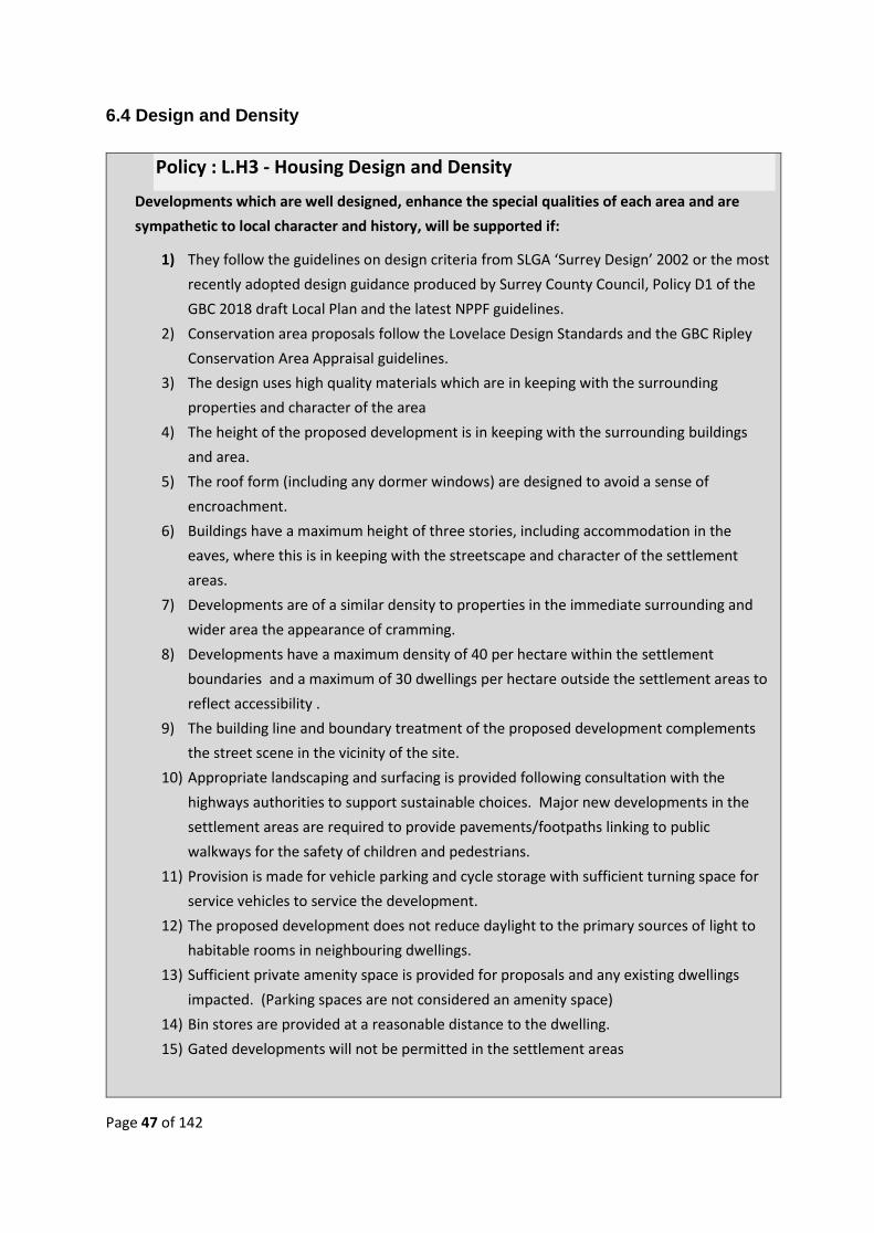
Page 47 of 142
6.4 Design and Density
Policy : L.H3 - Housing Design and Density
Developments which are well designed, enhance the special qualities of each area and are
sympathetic to local character and history, will be supported if:
1) They follow the guidelines on design criteria from SLGA ‘Surrey Design’ 2002 or the most
recently adopted design guidance produced by Surrey County Council, Policy D1 of the
GBC 2018 draft Local Plan and the latest NPPF guidelines.
2) Conservation area proposals follow the Lovelace Design Standards and the GBC Ripley
Conservation Area Appraisal guidelines.
3) The design uses high quality materials which are in keeping with the surrounding
properties and character of the area
4) The height of the proposed development is in keeping with the surrounding buildings
and area.
5) The roof form (including any dormer windows) are designed to avoid a sense of
encroachment.
6) Buildings have a maximum height of three stories, including accommodation in the
eaves, where this is in keeping with the streetscape and character of the settlement
areas.
7) Developments are of a similar density to properties in the immediate surrounding and
wider area the appearance of cramming.
8) Developments have a maximum density of 40 per hectare within the settlement
boundaries and a maximum of 30 dwellings per hectare outside the settlement areas to
reflect accessibility .
9) The building line and boundary treatment of the proposed development complements
the street scene in the vicinity of the site.
10) Appropriate landscaping and surfacing is provided following consultation with the
highways authorities to support sustainable choices. Major new developments in the
settlement areas are required to provide pavements/footpaths linking to public
walkways for the safety of children and pedestrians.
11) Provision is made for vehicle parking and cycle storage with sufficient turning space for
service vehicles to service the development.
12) The proposed development does not reduce daylight to the primary sources of light to
habitable rooms in neighbouring dwellings.
13) Sufficient private amenity space is provided for proposals and any existing dwellings
impacted. (Parking spaces are not considered an amenity space)
14) Bin stores are provided at a reasonable distance to the dwelling.
15) Gated developments will not be permitted in the settlement areas

Page 48 of 142
Reasoned Justification
This policy addresses the need for developments to fit into and complement the character and
scale of the of the surrounding area, both visually and by height. Compatibility in design is
important to enhance the visual aspects of any new development. The requirement is to provide a
strong sense of place and create attractive and comfortable places to live and a sense of social
cohesion.
Developments which incorporate modern building techniques combined with traditional materials
are acceptable if sensitively designed and positioned. Modern, energy-saving design and materials
should enhance build quality and appearance to benefit the overall development and respond to
the local character and history of the area.
Gardens provide valuable amenity space necessary for health benefits. Pavements are required
within in developments for pedestrian safety. Gated developments in the villages are not
appropriate for social cohesion in an area where ’community‘ featured as the number one positive
point in the Summer Survey 2015. There is a low crime rate throughout Lovelace and security
should be appropriate to the location. Parking is addressed in L.I4.
National guidelines require optimal use of land to meet the needs of housing but recognise that
density should reflect the desirability of maintaining an area’s prevailing character. Setting out a
range of densities to reflect the accessibility and potential of different areas is acknowledged.27
High-density housing can make a development feel cramped, oppressive and overcrowded. Equally,
density that is too low leads to sprawl, feelings of isolation, and car dependency and can
undermine the viability of public transport28. The fine line of density balance, while providing the
necessary mix of market and affordable housing, should not just reflect the character, mass and
landscape of the area but also the availability of public transport to promote sustainable travel
modes that reduce future car use.
The Plan supports developments which meet the local need to provide starter homes, affordable
homes and Rural Exception Sites where they avoid overdevelopment of a site but contribute to the
numbers of affordable homes. The three villages have very different characteristics in overall
design, however; rat-trap bond is widely used in Lovelace properties and essential for any addition
or adjoining development to enhance the visual appearance of the development.
Ripley
The Ripley Conservation Area Appraisal (CA)29 references the various architectural styles and
materials with particular features for four ‘distinct character areas’, i.e. Ripley Green, Newark Lane,
27 (NPPF, paras117, 122, 123, 2018)
28 (Surrey County Council, 2002) 29 (Guildford Borough Council, 2017)

Page 49 of 142
High Street and Rose Lane. Many of the guidelines, in terms of design and material (roofing /
fenestration / joinery / landscaping / boundary treatment) and density policy apply to Ripley,
though the diversity of design in Ripley requires developments to more broadly reflect their direct
surroundings. The CA makes reference to recent mixed-period buildings, especially around the
Green, as being of poor style, which is to be avoided for the future.
Within Ripley many structures are of Ockham brick or in some cases earlier Tudor-type brick
(thinner than Imperial and often showing signs of grass / straw where baked in the open). A recent
development in White Hart Meadows reflects Arts and Crafts style, though this is not one of the
many historical styles that predominate in the village. It does show that a development of a
reasonable scale can achieve a level of harmony with differing surrounding styles.
Ockham
Ockham has no Conservation Area Appraisal as yet, and has a large number of early timber-framed
buildings and several houses built in a distinct recognisable style, having been constructed by the 1st
Earl Lovelace in the 19th century.
The significant strategic site proposed for Ockham is likely to feature buildings quite unlike those
within the present built areas (5-storey blocks of flats are shown in the outline planning
application). If the site is developed, it is a requirement, as part of this policy, that all structures
should be sensitive to and complement the specific design characteristics of Ockham to ensure this
strategic development fits harmoniously into the surrounding landscape by virtue of design, height
and density, to avoid the development having a dominating effect on the surrounding landscape.
(The development will be built on a ridge 10m above sea level at its highest point). See Appendix
3.7.)
Wisley
The conservation area in Wisley includes the Grade I church and the adjacent Grade II farmhouse,
with further older buildings elsewhere in the village. The main building at the RHS is a Grade II
listed building in Arts and Crafts style, with more modern and industrial design incorporated
elsewhere in the Garden, itself listed GII* as Historic Parks and Gardens. Elsewhere in the village
redbrick and hand-made tiles predominate and this should be reflected in any future development.

Page 50 of 142
7. ENVIRONMENT POLICIES
7.1 Introduction
The subjects covered in this section relate to the Lovelace rural features and biodiversity, including:
• Local Green Spaces and Views of value to the communities (L.EN1)
• Biodiversity and Natural Habitats (L.EN2)
• Flooding (L.EN3)
• Light Pollution (L.EN4)
• Air Quality and Traffic (L.EN5)
Other environmental subjects have been excluded as these are already covered by existing
protection regulations. There is a hierarchy of international, national and local protection for sites30
with biodiversity of value, of which Lovelace has many. At a national level, the body for designating
sites is Natural England, a government body under the Dept of Environment, Food and Rural
Affairs. (The environment is not to be confused with Green Belt, the purpose of the latter is to
regulate the growth of settlements and preserve the openness of the countryside and prevent
urban sprawl).
International and National Protection
The protected areas within Lovelace with international and national level protections include:
• Thames Basin Heaths Special Protection Areas (TBHSPA/SPA) – Ockham and Wisley
Commons
• Sites of Special Scientific Interest (SSSIs) – Ockham and Wisley Commons, Papercourt Lake
and both sides of the River Wey in the Papercourt area, Ripley
(Appendix 1, Map 2)
The law is very strict in regard to internationally and nationally protected sites (SPAs and SSSIs) and
developments which will adversely affect these sites are not permitted unless there are exceptional
circumstances31. A proposal that would negatively impact on a SPA may be permitted, but only
where there are no alternative solutions and the proposal is necessary for imperative reasons of
overriding public interest. Where this is the case, compensatory measures are necessary. SPAs have
a buffer zone of 400 metres from the perimeter to any development, with a further 5 km buffer
zone in which development may be approved, but only if the impact on the SPA can be mitigated.
Mitigation is the provision of a Suitable Alternative Natural Greenspace (SANG), land suitable to
reduce the potential impact of residential development on the SPA by preventing an increase in
visitor pressure on the SPA.
30 (Surrey Nature Partnership, 2014) 31 (Ministry of Housing, Communities and Local Government, 2012)
Page 51 of 142
Local Protection
Local level protection consists of the areas of biodiversity and natural habitats areas designated by
Surrey County Council and Guildford Borough Council.
• Site of Nature Conservation Interest (SNCIs) - Ripley Green, the area around the former
Wisley airfield
• Local Nature Reserves (LNR) – Ockham and Wisley Commons, Ripley Nature Reserve
• Ancient Woodlands – Lovelace contains many ancient woodlands, forming a crescent from
north of the M25 through Ockham, through the south of Ripley to Burnt Common.
SNCIs and Ancient Woodlands do not receive legal protection but are protected through the Local
Authority’s planning system. SNCIs are areas of substantive nature conservation value
(BIODIVERSITY AND PLANNING IN SURREY – VERSION 2 (MAY 2014, PG 17), but their boundaries
can be amended by the Local Authorities, i.e. GBC. Local Authorities are required to apply the
follow principles: “planning permission should be refused for development resulting in the loss of or
deterioration of irreplaceable habitats, including ancient woodland ...unless development clearly
outweigh the loss” (NPPF, Para 118). In such cases, mitigation is through a SANG,
Landscape-scale Conservation
• Landscape-scale conservation - part of a Dept of Environment, Food and Rural Affairs
national strategy, Biodiversity 202032, to formally select areas as significant sites for nature
conservation
• Biodiversity Opportunity Areas (BOAs)33 – areas of targeted maintenance, restoration and
creation of priority habitats. Lovelace is covered by the Thames Basin Heaths (TBH06)34,
Rivers, Streams and Ponds (R04) (Waite, BOAs - Appendix 9: River Biodiversity Opportunity
Area Policy Statements, 2015)35, Thames Basin Lowlands (TBL02). These do not have legal
protection, but are government and local initiatives to conserve and enhance priority
habitats and biodiversity on a landscape scale.
Note: The Lovelace policies below aim to conserve and enhance the biodiversity and environment
and contribute towards the Government’s commitment for ours to be the first generation to leave
the environment in a better state than we found it.
32 (Department for Environment, Food and RuralAffairs, 2011) 33 (Mike Waite, 2015) 34 (Waite, BOAs - Appendix 4: Thames Basin Heaths Biodiversity Opportunity Area Policy Statements, 2015) 35 (Waite, BOAs - Appendix 5: Thames Basin Lowlands , 2015)

Page 52 of 142
7.2 Protecting Local Green Spaces (LGS)
Reasoned Justification
The Guildford Character Assessment36 shows Lovelace to be in Thames Basin Heath and Lowlands
and the 2015 public survey confirms that the local characteristic most valued by residents and
other stakeholders is its rural character.
The three villages in Lovelace are surrounded by countryside with no development other than
hamlets, individual dwellings, farms and non-residential sites (i.e. RHS Wisley, Send Prison, two
Thames Water sewage plants). Each settlement has numerous views which reflect the rural nature
of Lovelace and the three villages all have Local Green Spaces (LGS) of recreational value close to
the settlements.
Green areas can be designated Local Green Spaces if they are reasonably close to the community
they serve, are demonstrably special to local communities, hold a particular local significance, for
example because of their beauty, historic significance, recreational value (including as a playing
field), tranquillity or richness of wildlife, and are local in character and not an extensive tract of
land.37
A view does not have to be scenic in order to be valued; it may be valued for its contribution to the
nature, setting and historical significance of the area.
Lovelace includes a number of LGS, as shown in the list below, but this list excludes Ockham and
Wisley Commons, which are designated SPA/SSSI, and Ripley Green and TFM, the former Wisley
36 (Guildford Borough Council, n.d.) 37 (NPPF - para 100, 2018)
Policy L.EN 1: Local Green Spaces and Local Views
Sustainable development will be supported within the settlement areas where it can have a
positive environmental impact. Policies for managing development within the Local Green
Spaces listed in Appendix 4.2 should be consistent with policy for Green Belts. Development
which does not have a significant adverse effect on the local views shown in Appendix 4.3
will be supported.
In particular, developments are required to:
1) Respect the rural and landscape character and the setting of each of the three villages in
Lovelace, as defined in the Guildford Borough Council Landscape Character Assessment,
and the settlement areas as shown in Appendix 3.7
2) Be designed to minimise the effect on the existing landscape character and long distance
views across the Plan Area, or on attractive outlooks from within the built area.
3) To maintain the sense of place and rural character of the area, developments must not
link existing settlement areas or housing clusters which have green space between them.

Page 53 of 142
airfield, which are designated SNCI areas. A full list, with description and ownership of proposed
LGSs, together with a map, are shown in Appendix 4.2.
Ripley
• Allotments
• Bowling Club
• Ripley Court School Playing Fields
• Field for Ripley Rocks
• Nature Reserve
• Village Hall Field
Ripley Primary School Playing Fields Ockham
• Ockham Village Green, Elm Corner
• Three Farm Meadows
• Ockham Cricket Ground
Wisley
• Wisley Cricket Ground
• Wisley Archery Field
Local Views
Ripley Nature Reserve Ockham Village Boundary
Lovelace is surrounded by Green Belt and almost all the views from the villages and settlement
area are over countryside.
Various valued views and landscapes have been identified which have all, or most, of the following
characteristics:
1) They can all be seen from public rights of way or areas where the public has access rights-
legal or customary.
2) They provide a sense of tranquillity - including the absence of buildings and human
presence
3) They sustain the distinctive character of the Conservation Areas and contribute to their
setting

Page 54 of 142
4) They demonstrate the openness of agricultural land and other land uses in and around the
Conservation Areas
Views from many of the settlements are shown in Appendix 4.3.
Papercourt Lake

Page 55 of 142
7.3 Biodiversity and Natural Habitats
Reasoned Justification
Lovelace is a beautiful part of the Home Counties. It is the first essentially rural landscape
encountered when heading south-west out of London towards Portsmouth and forms a large part of
the green buffer between towns and suburbs of surrounding towns. It is therefore a hugely valuable
green space in the national context, is historically important and fortunate not to have been visually
destroyed by large-scale urban and suburban developments, as has happened in the nearby
surrounding areas.
Lovelace is full of ‘Green Corridors’ between the settlement areas, which include well established
mature trees, species-rich hedgerows, meadows, copses, bushes, orchards, woodlands, grass and
rush pastures. The River Wey and the Wey Navigation form part of the local ‘Blue Corridors’,
including rivers, floodplain, grazing marsh, ponds, wet woodland, watercourses, pools, canals, etc.
Policy L.EN2: Biodiversity and Natural Habitats
All development proposals must encourage local biodiversity and demonstrate that
developments will deliver net gains to wildlife, biodiversity and the landscape, as required
by the NPPF.
Development proposals adjoining the SPA, SSSIs or LNRs, or on/adjoining SNCIs, will not be
permitted unless:
1) The developer can demonstrate there be no loss of, or harm caused to the adjoining
area of natural habitat, and:
2) Developments avoid impacts on protected species and, where relevant, provide a survey
to determine the presence of protected species as part of the planning application
3) The provision of a SANG is included in the planning application
4) The developer demonstrates the delivery of net gains in biodiversity.
Where feasible, all developments will be required to:
5) Provide an Environmental Impact Assessment and use the Department for Environment,
Food & Rural Affairs’ Biodiversity Offsetting Metric and/or the Environment Bank
Biodiversity Impact Calculator.
6) Retain and enhance well-established species-rich features of the landscape, including
mature trees, hedgerows, ponds, and existing waterways.
7) Demonstrate justification for loss of trees and shrubs as part of a development.
8) Any relocation of habitat must demonstrate that the scheme cannot be designed to
accommodate the habitat in its existing location.
Page 56 of 142
The unlit roads encourage nocturnal wildlife including some endangered birds such as the Nightjar
and Dartford Warbler, which are on the RSPB’s amber list. Wild deer are commonly seen and many
species of bats abound. This environment supports many rare birds, invertebrates, reptiles,
amphibians, mammals, heathland plants and fungi. Woodland birds include the great spotted
woodpecker, woodcock and nuthatch, while skylarks, redshank and lapwing breed on the open
grasslands. The area includes one of only three breeding sites left for snipe in Surrey and is
important for wintering birds with over 90 species, including cormorant, black-necked grebe,
Slavonian grebe, marsh harrier, and many wildfowl such as tufted duck, mallard, shoveller,
goosander and large numbers of pochard. The lakes and streams support breeding kingfisher, great-
crested and little grebes, as well as sand martins.
Ripley Parish Council were recently granted permission to establish a new Nature Reserve and
pond at formerly derelict land adjoining West End Cottages and the burial ground. The site abuts
the current village boundary and will be a valuable and unique environmental asset for decades to
come. There are many benefits arising from the scheme, including an increase in biodiversity,
alleviation of surface water flooding, outdoor recreational village amenity, an enhancement of the
Green Belt and provision of an educational resource.
Key to development in Lovelace is the ability to harmonise with nature, return more to the
environment and ‘make space for nature’, particularly for significant major sites such as A35, TFM
former Wisley airfield and A43, Garlicks Arch. Well-designed developments will protect and
enhance habitats and the movement patterns of animals and wildlife such that the development
does not unnecessarily impact on them.
The Portsmouth Road at the southern end of Ripley provides a wildlife corridor towards Send
Marsh / Burnt Common, but it is recognised that the proposal to extend Send Marsh /Burnt
Common with new housing risks coelescencing with Guildford, as the landscape gap is set to be
further eroded by the proposed major development at Gosden Hill, south of Ripley, together with
Garlicks Arch. New Wildlife Corridors will be added to this Neighbourhood Plan as the need
becomes apparent.
The government’s biodiversity strategy for England, Biodiversity 202038, sets out the strategic
direction for biodiversity policy and Surrey Wildlife Trust’s vision for living landscapes, outlined in
‘A Living Landscape for Surrey’39 and ‘SWT Living Landscape Strategy40’ have regard to local
landscapes .
To ensure net gains in biodiversity in Lovelace, in recognition of the Government’s commitment to
halt the overall decline in biodiversity, the requirement of an Environmental Impact Assessment
and the Department for Environment, Food & Rural Affairs’ Biodiversity Offsetting Metric and/or
the Environment Bank Biodiversity Impact Calculator should be utilised for all significant major
developments. These would allow developers of these sites, e.g. TFM, former Wisley airfield, and
38 (Department for Environment, Food and RuralAffairs, 2011) 39 (Surrey Wildlife Trust) 40 (Surrey Wildlife Trust)

Page 57 of 142
Garlicks Arch, to assess the biodiversity impacts and provide mitigation measures with their
planning applications.
Natural England and Forestry Commission guidance (known as ‘standing advice’) should be
followed to assist planning decision makers with planning applications affecting ancient woodland
and veteran trees41.
Sir John Lawton’s recommendations in ‘Making Space for Nature’42 HM Government 2011 and
quoted by Surrey Wildlife Trust “Planning reform is seen as a further key enricher to catalyse
habitat protection, restoration and creation through strategic land use decision-making that
delivers truly sustainable development, designed to return more than they take from the
environment.”
41 (Forestry Commission and Natural England) 42 (Lawton, 2010)
Page 58 of 142
7.4 Flooding
Reasoned Justification
Lovelace includes several areas susceptible to frequent surface water flooding and occasionally
extensive river flooding at times when the country experiences exceptional rainfall (Appendix 1,
Map 6).
Local surface water flooding areas include:
• Ockham Road North at the junction with Ockham roundabout – frequently impassable after
heavy rain
• Ockham Road North at the junction with Guileshill Lane
• Upton Farm bends, Ockham Lane
• Ockham Lane near Bridge End (Most of Ockham’s lanes flood with rainwater from the
adjoining fields, which are higher).
• On the Portsmouth Road north of Ripley High Street – traffic is forced onto the other side of
the road to avoid the water
• Ripley High Street – at the traffic lights, on The Green side
• The slip road alongside Ripley High Street has frequently experienced heavy flooding
• At new houses at Peelers Place, Ripley High Street, on the site of the old police station –
‘ridges’ had to be added to prevent heavy rainwater flowing towards the houses
• Portsmouth Road, leaving Ripley to the south –; water flowing regularly on either side of the
road
• Newark Lane – subject to severe flooding on the bend near The Seven Stars pub
• Wisley Lane
Policy L.EN3: Flooding
All development proposals involving new buildings, extensions and additional areas of hard
surfacing should ensure that adequate and appropriate consideration has been given to
mitigating surface water flood risk.
Developers will be required to show that the development:
1) Will not increase the vulnerability of the site, or wider catchment area, to flooding
from surface water run-off
2) Provides mitigation measures to deal with surface water arising from developments
to meet GBC Surface Water Management Plan standards
3) Maximises the use of soft landscaping and permeable surfacing materials to increase
infiltration capacity.
4) Incorporates Sustainable Drainage Systems (SuDS) to manage surface water drainage
and provide lifetime maintenance.

Page 59 of 142
(PLUS MAP SHOWING WHERE THE ABOVE ARE)
Newark Lane at the junction with Newark Close 2018
The purpose of this policy is to minimise flood risk from new development and to protect existing
development from increased flood risk as a result of new development, whilst acknowledging the
protection afforded by the NPPF43 (paras 100, 101) and the possible requirement of an Exception
Test, together with any site-specific flood risk assessment required (NPPF, para 103, footnote 20
and para 104).
Flood risk must be a fundamental consideration for any development project regardless of scale or
type. Both rural and urban future land use changes are likely to alter the amount of surface water.
Future development is also likely to change the position and numbers of people and/or
developments exposed to flooding. Surface water runoff from development areas is very likely to
result in increased water levels within local rivers and watercourses compared to the natural
catchment levels.
43 (Ministry of Housing, Communities and Local Government, 2012)

Page 60 of 142
7.5 Light Pollution
Reasoned Justification
Ockham, Wisley and rural Ripley have no street lighting on the rural roads or in the rural settlement
areas. Ripley village has street lights in Ripley High Street with minimal street lighting beyond.
Apart from lighting on the A3/M25, the area is generally a dark skies area.
Policy L.EN4: Light Pollution
Artificial lighting on developments must take account of the ecological impact and
mitigation measures must limit the amount of light visible over the countryside. All
developments will conform to the Dark Skies principles below unless it is demonstrated to
be necessary and appropriate to depart from these principles, for example in relation to
highways safety.
1) The character of the area and the surrounding environment should take account of
the appropriate level of lighting for a development in a dark skies landscape
2) Development will include appropriate external lighting that does not significantly harm
wildlife, including the positioning, type of light source and level of lighting.
3) Street lighting kept to a minimum level and type to avoid light pollution. No lamp
standard on new developments will exceed six metres in height and will be shielded.
4) Street lighting will utilise yellow/orange light or the newer white light sources that
filter out blue or ultraviolet light. White light, with more blue content or with
ultraviolet content must be avoided.
5) Major developments to include ‘part-night lighting’ when light is not needed to reduce
any impact on sensitive wildlife.

Page 61 of 142
Source: https://www.lightpollutionmap.info/#zoom=12&lat=6674731&lon=-
51574&layers=B0TFFFFFFF
The impact of light on wildlife must include the consideration of all protected species as light spill
can compromise an existing dark landscape and/or affect natural systems (e.g. plants, animals,
insects, aquatic life). Lighting near or above the horizon should be avoided to reduce glare and sky
glow44. (https://www.gov.uk/guidance/light-pollution#possible-ecological-impact).
Four Principles of Dark Sky Friendly Lighting
• minimize the amount of illumination
• reduce number of lighting fixtures (to minimum level required)
• reduce lamp wattage (often by as much as 1/2)
• minimize the area of illumination (shine light only where it's needed)
Nocturnal wildlife, including endangered birds such as the nightjar (on the RSPB’s amber list), can
be affected by even very low levels of artificial lighting45, i.e. light pollution or “obtrusive light”, as
their sensitivity to light differs from humans. (Reference Royal Commission on Environmental
Pollution’s 2009 report, Artificial light in the environment). (https://www.gov.uk/guidance/light-
pollution)
The NPPF (para 203) requires Local Planning Authorities to “consider whether otherwise
unacceptable development could be made acceptable through the use of conditions”, if they meet
the “6 tests” (para 206). This would allow GBC planning decision-makers to add conditions to take
account of wildlife and dark skies policies at new developments.
44 (Ministry of Housing, Communities and Local Government, 2014) 45 (Royal Commission on Environmental Pollution, 2009)

Page 62 of 142
7.6 Air Quality and Traffic
Reasoned Justification
Each and every Lovelace survey highlighted traffic congestion and speed as the single most
important issues in the area, and traffic is the main cause of poor air quality. (See surveys,
Appendix 2). In 2017 the LNP steering committee, together with Ripley and Ockham parish
councils, commissioned three months of 24-hour air quality monitoring at two locations, one at
Ockham Common and one at the Ripley High Street/Newark Lane junction46, where traffic levels
46 (TRL Consultants (TRL), n.d.)
Policy L.EN5: Air Quality and Traffic-Pollution
Support will be given to significant major planning proposals which demonstrate air
quality will not significantly reduce as a result of increased HGV traffic to and from the
development site during construction and by general traffic after occupation.
Planning proposals which generate significant on-going increased transport movements
in Lovelace are required to undertake relevant assessment and provide mitigation for
increased traffic movements in locations where air quality is above UK and EU legal
limits.
Significant major developments (100+ dwellings) must meet all the provisions below,
where feasible, and GBC are requested to implement clause 1) as a monitor.
1) Designation of Ripley High Street as an Air Quality Management Area by GBC in the near
future to monitor air quality measurements during life of this plan and, as necessary, to
bring about reductions down to UK and EU legal limits.
2) Provision of an Ecological Assessment (EA) to assess the effects of major developments
on the environment.
3) Provision of a Construction and Environmental Plan (CEMP) to manage the planning and
implementation of construction activities in accordance with environmental
commitments, to include HGV routing and timetabling with particular reference to Ripley
village centre, Ockham Road North, Ockham Lane and Wisley Lane. This is to be agreed in
writing with the LPA, Ripley Parish Council and/or Ockham Parish Councils, dependent of
which parish the major development is situated. This is to be a ‘live’ document with
Parish/Borough Council reviews undertaken on a quarterly basis.
4) Provision of a Transport Assessment to identify measures needed to deal with he
anticipated transport impacts through Ripley village and the LRN. Developers are to
demonstrate encouragement for construction traffic to use the SRN.
5) A planning condition to prohibit HGV site deliveries/return journeys between 07.30 -
09.30 and 16.30 and 18.00 hrs every day, as part of a co-ordinated CEMP for each
significant planned development in the area. GBC Planning and Development to consult
and co-ordinate this with Highways England/SCC Highways as required.

Page 63 of 142
are very high, particularly during rush hours. Additionally, several diffusion tubes were positioned
at locations throughout Ripley village.
The reasons for the poor air quality at the Newark Lane junction are the volumes of traffic and the
stop-start routine caused by queuing traffic at this narrow bottleneck. A further problem at the
junction is vehicles turning into Newark Lane from Ripley High Street, only to find the vehicle in
front cannot progress along Newark Lane because of a larger on-coming vehicle and the road is not
wide enough for two larger vehicles to pass. This junction becomes blocked, cars can protrude onto
the High Street creating safety issues, and pedestrians crossing Newark Lane at this point are
endangered.
The air quality results evidenced air pollution in both areas to be 20% to 50% higher than the
maximum levels laid down by the EU Ambient Air Quality Directive
The main pollutants responsible are tiny carbon particles, Particulate Matter, (PM) and nitrogen
oxides (NOx) and the primary generator of these pollutants is vehicle traffic (Appendix 4.1).
The EU47 and the UK government48 49 have produced regulations defining the upper limits of
concentrations of a variety of pollutants, including gasses, principally Nitrogen Oxides (NOx) and
particulate matter (principally PM10 and PM2.5). NOx gases are heavier than air with a higher
concentration closer to the ground. These polluting particles and gases are generated by petrol and
diesel vehicles.
Ripley has two junior schools close to the centre of Ripley Village, one close to Newark Lane and one
in Rose Lane, both with nurseries and pre-school alongside, or as part of the school. The High
Street/Newark Lane junction is also surrounded by residential properties.
47 (European Parliament, 2008) 48 (DEFRA, n.d.) 49 (Legislation.gov.uk)

Page 64 of 142
The planned and proposed developments over the next 5-15 years would greatly increase ithe
construction traffic levels and create further problems with construction lorries being too large for
the local roads.
The 2018 GBC-Ptarmigan Statement of Common Ground50 states that the land at Garlicks Arch will
facilitate the delivery of A3 slip roads – “these are necessary primarily to mitigate the impact of A35
former Wisley airfield”. Page 10, ‘A3 Slips’, of the same document advises “The slip roads will
deliver significant environmental benefits across a wide area by addressing areas of congestion
through settlements”.
The RHS recently proposed an option to consider south slips at the Ockham roundabout, a
consideration excluded by Highways England (HE). The RHS believe the current HE proposals for a
new access will increase the mileage of the RHS visitors from the south, adding a total four miles to
their journey. Their concern is the strong possibility of decreasing, rather than increasing, visitor
numbers as a direct result. Of equal concern is that an increasing number of visitors will short-cut
through Ripley, Ockham and Wisley villages, but primarily Ripley.
Therefore traffic from the former Wisley Airfield, Ockham, Horsleys and the expanded RHS would
access these A3 slip roads at Garlicks Arch/Burnt Common by travelling through Ripley village, thus
increasing traffic driving through Ripley village rather than reducing ‘congestion though
settlements’. This policy addresses the immediate requirement to minimise and manage extra traffic
travelling through Ripley and on the LRNs of Wisley and Ockham.
As there is no overarching policy on air quality contained in the GBC 2017 LP51 and the TRL report
highlights compelling evidence for the implementation of an air quality policy52, Lovelace request
GBC to designate Ripley village as an Air Quality Management Area, as authorised under the
Environment Act 199553, during the period of major works in and around Lovelace and until air
quality levels comply with UK and International legal levels. Even if the TRL measurements be
considered not to meet the relevant legal standards, they do indicate a serious air quality issue,
particularly in the residential centre of Ripley and at Ockham close to the TFM development. The
NPPF, para 124, requires planning policies to contribute towards EU limits or national objectives for
pollutants, and air pollution in the area is already recognised by GBC.
The Guildford Borough Transport Strategy 201754acknowledges “Significant, recurrent traffic
congestion is experienced during peak hours on the A3 trunk road as it runs through the town of
Guildford and between the Ripley junction and the A3/M25 (Junction 10) Wisley interchange
junction, and also in Guildford town centre, especially on the gyratory system and its approaches.
Congestion on the SRN frequently spreads to the LRN and vice-versa.”
50 (Guildford Borough Council and Ptarmigan Land - Statement of Common Ground, 2018) 51 (Appendix ...... - AECOM Lovelace Neighbourhood Development Plan - pg 22, Conformity Check., 2018) 52 (Appendix ..... - AECOM - Lovelace Neighbourhood Development Plan Review, pg 22 - Evidence Analysis, 2018) 53 (GBC - Air Quality Duties, 2018) 54 (Guildford Borough Council, 2017)

Page 65 of 142
A Strategic Assessment carried out for GBC in 2017 comments on ”‘potential air quality issues’”
listed as a “key consideration’ for Wisley airfield,” with the latest position shown in a statement
made in the Air Quality Review (2017) “Due to the size of the allocated area, ……… it is likely there
will be a large increase in local traffic flows, particularly on the A3 passing close to the north of the
site allocation which would provide vehicular access to the area. The change in vehicle flows on
the A3 is anticipated to be over 21,000 vehicle movements per day. A change in flows of his
magnitude has potential to lead to a significant adverse effect on air quality at sensitive
receptors.”55 (pg 71).
At the southern end of Ripley, part of the Garlicks Arch development, (revised from 400 homes to
550 in an update to the GBC LP 2018 Inquiry), will be in Lovelace, the remainder in Send, and the
Burnt Common area to the south is proposed as a new employment allocation (Site A58, GBC
2017 Local Plan). Combined, these “could potentially create a risk of localised traffic issues. It is
notable that the employment floorspace could be expanded beyond the 7,000 m2 figure proposed
for this plan period.” Also “… more specific draw-backs, most notably in respect of … transport
(e.g. uncertainties regarding localised traffic impacts in the Send area) have been highlighted.”56
(p 88 and p 91).
It is also noted for proposed Three Farms Meadows development at Wisley “high car dependency
can still be anticipated” and for Send Marsh/Burnt Common “a degree of car dependency can be
anticipated”57 (Pgs 141-142). This is confirmed in the report produced after the Public Inquiry on
the former Wisley airfield (TFM) appeal, which states “private cars would be used for most trips“58
and “may well result in a high level of car-dependency and so fail to assist in the provision of a low
carbon economy”59
Policy L.EN5 plans to manage the inevitable increases in traffic levels and pollution in
the Lovelace villages and the local road network as a result of the significant major
developments at TFM and Garlicks Arch. The amount of major developments,
infrastructure and other works in and around Lovelace over the LNP period requires
traffic management and co-operation between relevant agencies to provide effective
solutions to improve air quality in Lovelace and meet UK and EU legal requirements.
Aspirations
• A joint HE, SCC and GBC working party to examine options for the A3 roundabout at
Ockham, taking account of plans and proposed development activity across the whole
region, i.e. co-operation and joined up thinking.
55 (AECOM, 2017) 56 (AECOM, 2017) 57 (AECOM, 2017) 58 (Former Wisley Airfield Inquiry - pg 119, item 22.7, 2018) 59 (Former Wisley Airfield Inquiry Report - pg 122, 2018)

Page 66 of 142
• Ban HGVs from travelling through Ripley High Street, Ockham and Wisley villages,
wherever possible
• Introduction of a 20mph zone through the central High Street, Rose Lane and Newark Lane,
Ripley
• A new crossing situated at the Ripley High Street junction with Newark Lane
• Hatching at the south side entrance of Newark Lane to prevent log-jams.
• In the event of any significant developments proceeding, a GBC Air Quality Monitoring Area
(AQMA) and Local Air Quality Action Plan be set up in Ripley High Street and at Ockham
roundabout. (https://uk-air.defra.gov.uk/aqma).

Page 67 of 142
8. INFRASTRUCTURE
8.1 Introduction
This section looks at the infrastructure required for developments in Lovelace, with particular
consideration given to significant developments of 100+ dwellings. Policies cover the following:
• Infrastructure and Utilities
• Public Transport and Green Travel
• Cycle Lanes and Public Footpaths
• Parking and Cycle Standards
• Social Facilities.
Over the 15-year life of the Lovelace Neighbourhood Plan, there will undoubtedly be small (under
10), major (10+) and very possibly significant (100 to 2,000+) developments. The aim is to ensure
that any development does not outstrip the capacity of existing infrastructure and/or that it
provides relevant infrastructure when required.
Infrastructure demand is generally dealt with between the Local Authorities, i.e. GBC, SCC, and
higher Government authorities, and developers as required. However, the level of change
proposed within, or close to, Lovelace warrants special attention to ensure it is delivered as
required.
The borough of Guildford in general has an extensive supply of natural gas availability and the gas
demands of the area are regularly assessed to balance supply with demand. There are, however,
some rural areas in the borough including Ockham and Wisley where mains gas is not available and
electricity or oil would be needed to provide heating and hot water.
Thames Water have stated that it was also unlikely to have sufficient waste water infrastructure for
the developments planned at Gosden Hill, Three Farms Meadows and Garlicks Arch and that they
require three years notice for major developments such as these.
There is a difficult balance between encouraging the use of public transport, cycling and walking
and continued car usage. Other than within Ripley village, most of Lovelace is not within easy
walking distance of services and social facilities. All the villages and hamlets are relatively isolated,
bus services are poor or non-existent and there is only one road with a cycle lane. The proposed
significant developments at either end of the ward are also isolated, one totally, one relatively.
This impacts on travel to railway stations, schools, walking to village centres with toddlers, carrying
shopping, cycling or walking to social facilities at night, etc. At the current time, it is unrealistic to
consider people will do anything but use cars to travel unless considerable new investment is made
in improved public transport and cycling/walking facilities locally as part of major new
developments.

Page 68 of 142
8.2 Infrastructure
Reasoned Justification
Smaller developments in Lovelace will link into the existing infrastructure. Significant developments
will require new infrastructure and should demonstrate how they take account of other
infrastructure requirements and developments in the area during the life of this plan, i.e. relating
to A3/M25 improvements, RHS expansion, Three Farms Meadows, The Drift, Garlicks Arch, Burnt
Common junctions, Burnt Common industrial area.
The Garlicks Arch slip roads are to be part-financed by developers, Wisley Property Investments Ltd
(WPIL), owners of the former Wisley airfield, and are proposed as mitigation to relieve traffic
congestion through Ripley. However, traffic from TFM, the RHS and general traffic to the north of
Ripley would need to travel through Ripley High Street to access the Garlicks Arch slip roads. As
traffic is currently the main problem in Ripley, it is difficult for locals to consider this as mitigation.
Where planning permission is granted on the basis of delivery of infrastructure, (i.e. a “Grampian”
clause), these are secured through ‘Section 106’ (S106) or Community Infrastructure Levy (CIL)
agreements which are legal agreements between the developer and the Local Planning Authority,
(i.e. GBC), whereby the developer makes a payment towards the wider geographical infrastructure
requirements of a development (S106) or contributes to wider infrastructure necessary to support
a development (CIL), e.g. cycle lanes, footpaths, community requirements.
Social Facilities Infrastructure
Social facilities infrastructure is needed to create or support strong and sustainable vibrant
communities. They should consider the needs of present and future generations by the provision
of sustainable local services that reflect the community’s needs and support its healthcare,
education, social and cultural well-being, as well as sports and entertainment facilities.
Policy L.I1: Infrastructure
All developments requiring new infrastructure prior to occupation should ensure:
1) Infrastructure is delivered when it is first needed
2) All local roads within developments have pavements for safe walking
3) Fast broadband facilities are provided prior to occupation
4) Any development larger than 1,000 homes and beyond easy walking distance (500
metres) of social facilities should provide social infrastructure facilities to make the
development sustainable, i.e. shops, pubs, restaurants, schools, GP surgeries and
community facilities
5) Related infrastructure improvements are delivered at each stage of development to
allow for the population growth.

Page 69 of 142
Broadband facilities in Lovelace are poor outside of Ripley village, with download speeds well
below the promised national minimum of 10Mb per second. Over 50% of both business and
residential respondents to a Surrey-wide survey have said that their current broadband service is
inadequate. Developments should ensure fast broadband is available for commercial and social
reasons.
Should either, or both of the Lovelace significant sites in the GBC 2017 LP be approved, a good
infrastructure model is the development at Dickens Green60, Solihull, located 3 miles from Solihull,
Birmingham. This is a sustainable, self-sufficient, new village of 1,672 dwellings, housing 4,000
people, and provides a range of social and transport infrastructure to encourage social cohesion
and minimise car use.
The five key elements of the Dickens Heath Plan were that the new settlement should:
• be in a suburban location close to Solihull, with existing rail and road infrastructure
• have a clear identity which gives residents a sense of place and belonging
• echo the traditional features of village development including homes, employment,
recreation, social and welfare facilities intermixed to create a cohesive whole
• provide a range of proportionally sized housing, from first-time buyer housing through to
family housing and smaller units suitable for the elderly, thereby creating a mixed community
of all ages and incomes
• create a safe and pleasing environment for pedestrians while still accommodating the motor
car, but without allowing it to dominate the environment.
If TFM were to receive planning permission, it could be considerably larger than Dickens Heath. If TFM
is approved with 1,000+ dwellings, then it is part of this policy for TFM to include the range of social
facilities as at Dickens Heath. This would encourage less car usage to access social facilities such as
restaurants, pubs, chemists, etc.
60 (Solilhull Borough Council, n.d.)

Page 70 of 142
8.3 Public Transport and Green Travel
Reasoned Justification
All the local surveys undertaken (Appendix 2) show the majority of Lovelace residents and workers
travel by car to access shops, medical facilities, restaurants, pubs, schools, railway stations and
work places. This is unlikely to change without greatly improved public transport facilities
throughout the borough and Lovelace has poor, or non-existent, public transport facilities.
Ripley has one bus per hour, approximately, between Guildford and Kingston, via Ripley and
Cobham, subject to traffic conditions. The last bus from Guildford is at 19.1861. The are two buses a
day to Woking, and the last bus from Woking is at 17.4962.
Ockham and Wisley have no direct bus services at all and the nearest bus stops for
Guildford/Kingston are on the A3, although these will be moved/removed when the A3/M25
junction improvements take place. There is no bus service between Ripley, Ockham and Horsley.
Lovelace has no rail links and the nearest stations are Woking with its fast, non-stop services to
London Waterloo, and West Byfleet with its large car park. Both are very popular with locals which
contributes to the traffic through Ripley and Wisley Lane. Other stations, with slow trains to
Waterloo, include Cobham, Horsley and Effingham Junction, accessed via the unlit country lanes
with no pavements or cycle lanes. Most locals access the stations by car and commuters are often
dropped off and collected to avoid daily parking charges.
Guildford station is poorly located, in the middle of the town’s shopping centre and cut off by the
gyratory traffic system that is renowned for its traffic congestion, making it is an impractical choice
for Lovelace residents.
61 (Arriva, n.d.) 62 (Stagecoach, 2017)
Policy L.I2: Public Transport and Green Travel
Developments will be supported which reduce the need for car use and offer sustainable
public transport choices that increase, or otherwise support, the delivery of public
transport services in perpetuity, where:
1) All significant developments submit a Green Travel Plan , as defined by the Surrey
County Council Green Travel Plan Good Practice Guide 2010, with their planning
application, and require:
2) Provision of a public bus service, commensurate with the size of the development, to
local facilities and railway stations, including a regular bus service to Woking railway
station, in particular, for development of 1,000+ dwellings.
3) All major developments to include car-charging points for electric cars.
4) All major developments to include parking spaces solely for car-share clubs.

Page 71 of 142
Although the rail passenger table below shows Guildford as slightly more popular, this undoubtedly
includes passengers from all around Guildford. An additional reason for Lovelace preferring Woking
to Guildford is that it adds a further 15 minutes to the train journey time, increases the cost and
the trains pass through Woking on their way to Waterloo.
The table below shows the passenger entries and exits from the nearest railway stations as of
2011/12 and the percentage increase from 2001/02.
Station name Passenger entries
and exits
Change from 2001/02
to 2011/12
Guildford 7,992,712 +33.7%
Woking 7,358,408 +27.7%
West Byfleet 1,225,308 +40.5%
London Road (Guildford) 499,810 +67.3%
Horsley 405,686 +44.0%
Effingham Junction 285,398 +17.7%
Clandon 186,534 +33.1%
Source: Government Office of Rail & Road (www.orr.gov.uk )
There are key capacity and adequacy issues for rail in Surrey63, several of which relate specifically to
Guildford borough. Trains between Portsmouth/Haslemere and London Waterloo use part of the
South West Main Line, the capacity of which will be a major long-term challenge as demand already
exceeds the seats available during the busiest times on weekday services. Passenger numbers will
grow by 24% between 2011 and 2031 – about 1% per year (Network Rail, July 2011). Network Rail
has made commitments for improvements to be delivered in the short-term but has no long-term
plans.
As TFM will probably have an average of 2 cars per household, up to 4,000+ cars could leave and
return to the site daily, whilst Garlicks Arch could have 800+ cars doing the same. The draft GBC
2017 LP shows the withdrawal of a bus service from TFM to Woking64, yet a regular shuttle bus
between both developments to Woking station would dramatically reduce car usage from both
sites and provide a service for local people. Woking station ranks second in commuter numbers and
is the station of choice for many in Lovelace, who mainly travel to it by car as there is no suitable
bus service. The inclusion of a regular Woking bus service would serve commuters and shoppers
leaving school runs as the most regular daily car usage need and some of that could use these
buses. Good public transport is the most sustainable way to reduce car usage from significant
63 (ARUP, 2013) 64 (Guildford Borough Council - draft LP Consultation Document - pg 225-6, 2017)

Page 72 of 142
developments, as is proven by Dickens Heath, previously a semi-rural location, with two railway
stations less than 15 minutes’ walk, plus 12 local bus services going in every direction. A bus service
between East Horsley and Woking, via Ockham, Wisley and Ripley, would be strongly supported to
reduce, rather than increase, air quality issues. Encouragement of car sharing and the addition of
electric car-charging points at significant sites are also supported.
Aspirations
• Increase the frequency and destinations of local bus services.
• Provide low-cost fares for station destinations, to encourage usage.
• Provide real time information at all bus stops.
• GBC to reinstate the requirement for a regular bus service to Woking if the former Wisley
airfield receives planning permission for development
8.4 Cycling and Walking
Reasoned Justification
Lovelace is not well served with cycle lanes and pavements. There are no full specification cycle
lanes (separating cycles and vehicles) in Lovelace. Cycle lanes to Guildford (7 miles), and Woking (5
Policy L.I3: Cycle Lanes and Public Footpaths
Developments which support and encourage cycling and walking as safe and sustainable
means of travel to nearby facilities will be supported. The creation of separate cycle lanes
and provision of places where walking and cycling have priority over motorised traffic, for
safety reasons, will be supported.
To assist these provisions, developments must include:
1) S106 contributions for appropriate improvements to cycling and walking provision
related to the development and to link the development to existing cycle routes and
footpaths
2) New developments must ensure existing footpaths, footways, Public Rights of Way and
cycle paths are preserved and enhanced to encourage walking and cycling.
3) Any significant new development, must include provision for linking into the existing
network of footpaths, Public Rights of Way, and cycle paths and involve the local parish
councils in planning these provisions.
NOTE: It will not normally be sufficient for developers to just make a financial contribution
to GBC or SSC as their means of providing these facilities if at all possible. They are to
deliver these facilities.

Page 73 of 142
miles) are unsafe as they cover only part of the route. The addition of new cycle lanes on most of
the local road structure is impractical due to the narrowness of these roads.
Pavements are scarce in the ward and not all roads have lighting outside of Ripley village, they do
not provide a sense of safety and security for those walking alone or cycling at night.
There is a footpath from the Ockham roundabout to Ripley but it is not well maintained, has no
lighting and is isolated and invisible from the road. The distance on this path is approximately one
mile from Ripley village to the edge of TFM.
In Ripley village, people walking to work or to the Ripley schools generally live within easy walking
distance. In Wisley workers who live in RHS accommodation near the Gardens walk to work, those
living outside Wisley generally drive although some cycle.
The rural footpaths are used by leisure walkers, ramblers and dog walkers from within and outside
the area. They use the Wisley and Ockham Commons, Ripley Green, Papercourt Lake and the paths
along the River Wey and the Navigation.
There is a recurrent need for footpaths to be maintained by the relevant authority and kept free of
all overgrown vegetation. The public Pigeon House bridge across the River Wey was damaged
during the floods of 2013, removed but not replaced by Surrey County Council due to lack of
funding. (See Appendix 1, Map 9, for map of existing footpaths).
Green Travel is an important consideration in all significant developments. Section S106
contributions from any such developments are encouraged to create and enhance cycle routes and
footpaths, where possible. Parish councils receiving their 25% portion of Community Infrastructure
Levy (CIL) will have discretion to address demands that development places on the area.
Aspirations
• A bike-hire scheme.

Page 74 of 142
8.5 Parking
Policy L.I4: Parking
Parking management is essential to avoid increasing on-street parking, particularly in Ripley
village, and all developments must ensure they meet the parking standards below:
Residential Parking
1) All residential developments within Lovelace which provide parking within its designated
land boundaries to meet the expected demand of the development will be supported.
On-street parking for residents or as overflow facilities is not supported.
2) Each development must provide parking bays of a minimum size of 6m x 2.6m, or 7m x
2.6m if parallel parked, and/or garages with a minimum size of 7m x 3m to
accommodate modern vehicles and some storage.
3) Minimum parking standards are:
a) Studio apartments: 1 car space minimum
b) 1-bedroom dwelling: 1 car space minimum
c) 2-bedroom dwelling: 2 car spaces minimum
d) 3 bedrooms or more dwelling: 3 car spaces minimum
e) Elderly (sheltered): 0.5 car spaces per unit
Residential Visitor Parking
4) Visitor parking must be provided within the curtilage of the development. Minimum
levels of visitor parking, which must be signposted, are as follows
a) 2 – 5 dwellings 1 space
b) 5 – 10 dwellings 2 spaces
c) 10+ dwellings 1 space per 5 dwellings
Commercial Parking
5) All commercial developments must provide on-site car parking to meet the maximum
predicted use for daily company usage unless located within easy walking distance of
good public transport facilities.
6) Overnight parking needed for company vehicles must be provided on-site.
7) All commercial developments must provide on-site car parking to meet the maximum
predicted use for daily company usage unless located within 500m of good public
transport facilities.

Page 75 of 142
9) Car parking spaces for employees will provide 5 spaces per 100 sq. m. of commercial space.
Parking on non-residential sites shall not be below the prevailing maximum standards in
use by Guildford Borough Council (i.e. the maximum for the Borough shall be applied as a
minimum in Lovelace). Note: all figures to be rounded up
10) The provision of visitor parking facilities in communal and commercial areas of strategic
new developments would be supported, as would the use of S106/CIL monies towards this
objective.
Public Parking
11) There will be support for land around the settlement areas, particularly Ripley Village, to be
repurposed in perpetuity where the relevant Parish council considers it appropriate.
Cycle Stands
12) To encourage cycling as a means of sustainable travel, cycling-related provisions will
include:
13) All new housing developments to provide one cycle space for each dwelling within a block
of flats.
14) Commercial developments will provide a minimum of 5 Cycle Parking spaces per 100 sq.m.
of commercial space.
Reasoned Justification
This Neighbourhood Plan fully supports green travel, but the area is too rural and undeveloped for
this to be practical in many parts of Lovelace as the narrow roads are inadequate for this purpose.
High car usage was identified in the 2011 census within Guildford Borough, this is particularly true
of Lovelace which lacks Guildford town’s infrastructure. Car usage is the main form of transport at
the current time and this is unlikely to change significantly in the foreseeable future.
The parking standards in the policy are designed to manage car parking, particularly in Ripley
village, which has to provide for residential, employment and visitor parking. The NPPF changes
dated 25 March 2015 acknowledged there are situations where car usage is required. ‘Local
planning authorities should only impose local parking standards for residential and non-residential
development where there is clear and compelling justification that it is necessary to manage their
local road network.65’ Ockham and Wisley do not have need for car parking management, but
Ripley village does. Additional development and increasing visitor numbers will inevitably add to
the need for extra parking in Ripley village in the foreseeable future.
65 (Ministry of Housing , Communities and Local Governmenet and The Rt Hon Sir Eric Pickles)

Page 76 of 142
There is two-hour unmonitored parking in Ripley High Street and unrestricted parking outside the
village centre. There is a total of about 350 parking spaces in the village centre, which is sometimes
insufficient and many spaces are used inappropriately. Car parking facilities include the free car park
(often used by residents and workers), on-street parking (used by shoppers and workers) and the
‘unofficial’ car parks on The Green (used by walkers, commuters and residents). Many High Street
residents have no on-site parking facilities and use street parking, or verges, only to receive parking
tickets. Visitors park where they can and if the car parks are full, they park on verges, on pavements
forcing pedestrians onto the street, and even on residents’ private off-street parking spaces in front
of their homes.
Delivery vehicles often park on the High Street pavements forcing pedestrians onto the road, and
lorries and vans parked in the bus bays are a daily occurrence.
Pavement Parking Ripley
The 2011 Census figures showed 33.2% of people living in the area are between the ages of 18 and
4466, and 9.5% are “non-dependent” children67. However, this does not reflect the increased
current trend for many young people to remain or return to the family home as house purchase is
beyond their means. These adult children often have cars, increasing the need for parking space to
three or four cars per household68. The parking standards and parking space sizes in the policy take
account of this need69.
66 (ONS: Census, 2011) 67 (ONS: Census, 2011) 68 (ONS: Census, 2011) 69 (Dept for Transport, Pg 110)

Page 77 of 142
Former Sage Interiors, Ripley, converted in 2017 from commercial to residential
Insufficient parking in Ripley Village has been shown to deter employment. Belle and the Dragon
restaurant chain decided not to purchase the former Sage Interiors, a large, High Street property,
due to inadequate public parking facilities. The 2016 Business Survey results and anecdotal
evidence show residents of nearby towns and villages by-pass Ripley to shop due to this problem.
(Appendix 2.6).
Aspirational
• Restrictions on all-day parking in Ripley.
• Provide timed parking in the car parks to discourage daily commuter parkers leaving multiple
cars in the car parks and continuing in one vehicle
• Provide Residents Parking Permits for those with no off-street parking facilities
• Provide contract parking for employers and employees to free up High Street parking spaces
• Provide new small, unobtrusive public car parks alongside the settlement areas for workers
and visitors.
• Stop pavement parking, which forces people to into the road.
• Encourage car sharing for employers and employees with reduced parking charges for proven
local car sharers.
Page 78 of 142
8.6 Community Facilities
Reasoned Justification
Community facility provision is essential to create and enhance thriving communities. Ockham uses
its cricket pavilion, cricket grounds and Parish Rooms for community events; Wisley has a cricket
pavilion but no cricket club at present and has few, if any events outside those held by the RHS;
Ripley has numerous local clubs and organisations, plus regular monthly and annual events.
Ripley Village Hall, built in the early 1970s and designed to last 30 years, is the main indoor venue,
but badly in need of replacement.
Ripley Parish Council own 38 allotment plots, 21 full and 17 half. There are 28 plot holders, nine of
whom live outside of Lovelace, and a waiting list of seven people, six of whom are within Lovelace.
The RHS also have some allotments.
This purpose of this policy is to encourage new and/or expanded facilities which benefit the
community.
Policy L.I5: Provision of Community Facilities
To provide for social facilities on new developments and the enhancement of current
facilities, developments are supported which:
1) Retain or, in the case of significant developments, provide, community facilities and land
for community use. Proposals for increases/improvements in community facilities on
Local Authority- or community-owned land will be supported.
2) Provision and improvements in community facilities will be supported as an appropriate
use of CIL funds and Section 106 payments.

Page 79 of 142
8.7 Healthcare and Educational Provision
Reasoned Justification
It is recognised that significant developments will require liaison with the Local Authority, the
County Local Authority and the relevant educational and health care authorities prior to submitting
a planning application
Healthcare provision in Lovelace is limited and it no longer has a doctor’s surgery, although
facilities are available in neighbouring parishes. There is no demonstrable need for additional
facilities in Lovelace at present but significant developments will upset this balance.
Policy L.I6: Healthcare and Education
Significant developments which consider healthcare and educational needs for the
development prior to the planning application will be supported where:
1) It is evidenced that the developer has consulted with the local county authority
(SCC), Clinical Commissioning Groups (CCGs) and Local Authority (GBC), or relevant
subsequent authorities during the life of this plan, to ascertain the healthcare and
educational requirements for the new community on the development
2) the proposal for healthcare and educational facility provision is calculated to meet
revised local needs.

Page 80 of 142

Page 81 of 142
9. BUSINESS AND EMPLOYMENT
9.1 Introduction
Lovelace has an active and diverse local economy. Ripley village is a vibrant retail and commercial
centre, Ockham has no commercial centre at all, nor does Wisley. Wisley village has the largest
employer in Lovelace, followed by the golf clubs in Ockham and Wisley and one employer in Ripley
village. Other employment in Lovelace is, in the majority, agricultural, horticultural and equine-
related activities or home working.
The polices contained in this section are to encourage commercial growth and provide local
employment in Lovelace and include:
• Preserve and Develop Lovelace Business (L.BE1)
• Agricultural and Horticultural Land Use (L.BE2)
Ripley
Ripley village is proposed as a District Centre in the draft GBC 2017 LP. It is the commercial hub of
Lovelace and has become a ‘destination’ village. Its compact High Street provides a range of service
and hospitality facilities, i.e. shops, coffee shops, pubs and restaurants, attracting walkers, cyclists
and tourists as well as locals. The majority of businesses in the High Street are privately owned and
provide a range of employment opportunities.
Shops are at ground floor level only and retail premises rarely stay empty for long when marketed,
offices are at ground and first floor level The largest employer in Ripley, PharSafer, is in the village
centre, occupying a two-storey office with some car parking. The company employs 48 full-time
staff, most of whom live outside the area.
There are pockets of small, light industrial sites in and around the village, but those in or near the
centre are slowly being redeveloped to provide housing. One proposed development of 26 homes
plans to include two shops, but this is rare. There is little opportunity for new employment floor
space other than on the few remaining brownfield sites in Ripley village and on the Portsmouth
Road, outside the village, but residential usage usually prevails against business usage.
The major constraints to conserving and expanding business in Ripley are loss of commercial
premises to residential, insufficient overall parking and poor public transport.
Wisley
Wisley Village has the smallest population but one of the largest employers in Guildford borough.
The Royal Horticultural Society (RHS) employs 350 full-time and 100 part-time staff; has 221
volunteers and 24 trainees. When its expansion is complete, it expects to increase staff levels by
10%.
Apart from the RHS there is a group of formerly derelict farm buildings, which were converted to
offices in 1991. Known as The Courtyard, these house a National Trust office, with 65 employees

Page 82 of 142
based there, although only an average of 30 are there at any one time, and two other separate,
non-related, offices employing 38 people in total.
The Wisley Golf Club straddles the Lovelace/Pyrford boundaries and employs 72 full-time and 28
part-time/casual staff, of whom 14 are Lovelace residents.
Ockham
The largest employer, on the Ockham/East Horsley boundary is The Drift Golf Club, employing 44
full-time, part-time and casual workers. Martyr’s Green Montessori employs 20 full-time and part-
time staff. Other employment is agricultural or horticultural related, scattered thinly across a wide
area.
Home Working
Other employment outside retail and agricultural tends to be homeworking. The 2011 Census
showed that 16.6% of Lovelace residents work from home, a figure that will have increased
significantly since then.
Lancaster University70 say the UK is on the verge of a flexible employment tipping point and 70% of
companies will have employees, known as ‘digital nomads’ working remotely from home by 2020
or setting up small home offices to create employment. The use of work/live units are therefore
supported on some larger new developments as is fast broadband for all new or change of use
developments.
70 (Lancaster University Work Foundation, 2016)

Page 83 of 142
9.2 Preserve and Develop Business & Employment
Reasoned Justification
The purpose of this policy is to encourage and support business growth appropriate to each
location and retain or encourage sustainable premises providing employment.
Commercial activity is vital for Ripley village in particular and support is given to new retail and
service facilities which provide employment. Support is given to rural business which is appropriate
to the rural areas and does not cause nuisance to nearby residents or add significantly to road
traffic at peak times.
The Lovelace 2016 Business Survey received a response of over 50%, with most businesses planning
to stay in the area and expecting that their business would expand, although some believed
inadequate broadband was a problem. 97% wanted to encourage new business. Local community
Policy L.BE1: Change of Use from Commercial to Non-Commercial
Proposals which provide sustainable growth and expansion of employment floor space to
create or expand employment opportunities will be supported. Proposals which would
result in the loss of shops and pubs, particularly in Ripley village centre, or community
facilities, or requiring HGV movements though the villages will not be supported. Support
is provided where:
1) They are of a scale appropriate to the character and appearance of the area.
2) They provide parking in accordance with Policy L.I4 of this plan.
3) They do not have an impact on nearby residents by way of noise, smell or nuisance.
4) Applications which would result in the change of use of non-residential buildings must
provide marketing evidence alongside any planning application. The marketing must be
carried out in accordance with the stipulations below:
5) For Class A1 units, 12 months of sustained and widespread marketing of premises at a
realistic price, as proven by a local valuation report, has been undertaken
6) With the exception of A1 units, any other A Uses and B1 premises 6 months of
sustained and widespread marketing of the premises at a realistic price, as provide by a
local valuation report, has been undertaken.
7) the current business is not a well-used service facility or of community benefit, an
example being an art gallery that is rarely open and employs no one
8) change of use to general industrial use (B2) or distribution and storage uses (B8) or
other such uses will not have a severe traffic impact within the village
9) change of use will adhere to commercial parking policies in L.I4.

Page 84 of 142
surveys showed residents and visitors also encourage business growth in the area, particularly
service facilities; 33% of the 258 respondents of the Lovelace 2015 Summer Survey want more
retail in Ripley village, i.e. shops, restaurants, a bank, etc. The retention of retail premises in the
village supports the community’s desire to create and retain these facilities (Appendix 2.6 –
Business Survey Summary and full survey http://lovelaceplan.co.uk/survey-form).
Retaining service facilities, i.e. the chemist, post office, florist, etc., reduces the need to travel
outside the village. Many local pubs are changing to gastropubs/pub restaurants and retaining the
few remaining ’real’ pubs is important as they provide a valuable facility for casual social relaxation
and interaction for locals and visitors.
The sustained widespread marketing requirement (L.BE1, 3)) is to discourage premises being left
empty where there is a covert desire to convert to residential. When marketed, few commercial
outlets in Ripley remain vacant for long.
Lutidine House, Ripley
Office premises in the village, many of which have provided significant employment, are being
converted to residential by taking advantage of planning or permitted development to convert to
residential, e.g. the former Sage Interiors, a large building in the centre of Ripley, received
permission to convert to a single residence. Permitted development saw Lutidine House, formerly
offices on the edge of the village convert to 18 flats; Ballpenny House and the former Jeffrey
Flanders office, in central locations on Ripley High Street, are also being converted.
(PICS – Ballpenny and J.F. for appendices)
Aspirational
• Improved high speed broadband throughout Lovelace.
• A proportion of home/work units in residential developments that were formerly
brownfield.

Page 85 of 142
• Shared office facilities, or a Business Centre, with hot-desking, shared office space, and
meeting rooms for hire. (Possibly in a new village hall).
• Internet pick up/drop off “locker” facilities, as at Morrisons in Woking.

Page 86 of 142
9.3 Rural and Agricultural
Reasoned Justification
As the LNP area is rural, it is important to protect farming and agriculture-related activities to
ensure the rural character of the countryside is preserved and managed in a sustainable and
sympathetic manner. Lovelace agricultural land includes DEFRA-defined grade 2 (very good
quality), grade 3a (good) and 3b (moderate) land, suitable for producing moderate to high yields of
arable crops and grazing grass for cattle. As the Surrey Countryside and Rural Enterprise Forum71
(SCREF) describes farming as "an important land based sector in rural Surrey" and its vision for
farming and horticulture is "viable, successful, sustainable and resilient to contribute to the rural
economy and landscape", the Lovelace Neighbourhood Plan will encourage such use of agricultural
land.
Lovelace already has thriving businesses using green space and woodland, which provide
employment, e.g. cattle and sheep-grazing, livery stables, flower and seed production, nurseries,
local pheasant shoots, etc., plus the flagship 240-acre RHS Gardens at Wisley.
Agricultural, horticultural and equestrian uses, plus small offices and workshops which do not
detract from the landscape, do not require vehicles over 7.5 tons on narrow country roads and do
not create nuisance out of character with the peaceful nature of the countryside, are encouraged
to sustain and enhance a viable rural economy and provide employment.
71 (Surrey Countryside and Rural Enterprise Forum, 2015)
Policy L.BE2: Agricultural and Horticultural Land Use
Proposals that will contribute to rural prosperity will be supported where it is
demonstrated that: :
1) They relate to agricultural and horticultural small business activity.
2) They continue to provide employment.
3) There are no severe adverse traffic and HGV impacts on the LRN
4) The development conforms to Policy L.BE1, 4) regarding negative impacts and
loss of amenity.

Page 87 of 142
APPENDIX 1. APPENDIX 1. MAPS
Map 1 - Lovelace – Green Belt and Surrounding Conurbations
Map 2 - Environmental Designated Areas

Page 88 of 142
Map 3 - Woodland and Grassland
Map 4 - SSSI Impact Zones

Page 89 of 142
Map 5 - Flood Risk

Page 90 of 142
Map 6 - Bus Stops and Schools
Map 7 - Public Rights of Way
Map 8 - Footpaths

Page 91 of 142
Map 9 - Road Noise

Page 92 of 142
APPENDIX 2 SUMMARIES OF SURVEYS A series of public surveys were undertaken in 2015-2016, as shown below with summaries of the
results. The summaries and full responses to the surveys is available on the LNP website at
http://lovelaceplan.co.uk/survey-form/
2.1 The 2015 Summer Survey Summary
This survey was taken by the Lovelace Neighbourhood Plan Group to establish the priorities and
concerns of all those with a stake in the villages of Ripley, Ockham or Wisley, prior to drafting a
neighbourhood plan for the area.
This public consultation was undertaken at local public events during summer 2015. These included
the Ripley Event, Ripley Rocks, the Farmers Market, plus fetes and school fetes, all of which attract
locals from Lovelace and the surrounding areas. Ockham had one public event but did not conduct
the survey and Wisley did not have any public events.
It was a simple 5-question survey;
a) What do you like about your village?
b) What do you dislike about your village?
c) What is missing from your village?
d) What sort of place would you like your area to be?
e) What else in Lovelace is important or should the Neighbourhood Plan address?
This was an important survey as the responses established the focus of the Lovelace
Neighbourhood Plan and its policies.
A summary is shown below with full details on the www.Lovelaceplan.co.uk website.
2.1.1 What's Good, What's Bad?
Top of the list is the friendly community spirit, followed by Lovelace remaining essentially a rural and
unspoilt location, which is largely due to the planning restrictions currently in place, including the
Green Belt provisions.
The biggest negative by far was the traffic, both the amount and the speed, along with its associated
problem - parking.
After this was the concern of over development changing the character and landscape of the area and
the expected increased traffic and further parking issues.
2.1.2 What Is Missing?

Page 93 of 142
In keeping with the outcome of the ‘What’s bad?’ question, the most important thing missing is
solutions to the traffic and parking problems. There were lots of suggestions, of which, turning the A3
into a proper by-pass for Ripley, was by far the favourite. Transport related planning is in the hands of
Surrey County Council and Highways England, the neighbourhood plan cannot impose solutions to
these issues, but the information gleaned from the survey will enable representations to be made by
appropriate bodies on behalf of the area.
When it came to missing facilities, in spite of everything the village has, the list was long. Top of it was
more and better schools, closely followed by the new village hall. This is combined with a desire for
more sports facilities, including tennis and badminton.
Improved public transport, especially a more reliable bus service was much requested and some
people have felt the departure of the both the police station and the old post office keenly.
On the commercial front, there appears to be scope for more shops, particularly a butcher and a
fishmonger, with many other suggestions too.
On the question of the housing requirement in the village, most people seem to accept the need for
some ongoing development, but the feeling was that this should be more carefully controlled and
focus on smaller, cheaper housing units.
2.1.3 What Else Is Needed?
This need for greater control over housing development in Ripley came across very strongly in this
section.
There was also a very strong steer to resist the proposed Three Farms Meadows (former Wisley
airfield) development, although this was not asked, or mentioned, in the survey questions.
2.1.4 What Sort of Place Should Ripley Be?
YRespoindents would like Lovelace to remain much as it is, with a few additional facilities, better
parking and reduced traffic.
They accept limited and controlled development, especially of housing.
2.1.5 Other Issues
The Proposed Development on The Wisley Airfield Site (Three Farms Meadow)
We did not ask about this as it is a ‘strategic’ site in the emerging GBC Local Plan, and strategic sites
are outside the scope of a neighbourhood plan.
However, respondents chose to give us their views spontaneously.

Page 94 of 142
Of those who specifically mentioned either Wisley Airfield or major housing developments in the area,
we found one respondent in favour and 120 against. To these might reasonably be added the 427 who
opted for their village to be a ‘Quiet, rural, protected space’.

Page 95 of 142
2.2 Summer 2015 Survey Analysis
In the summer of 2015 a survey was conducted in the Lovelace parishes of Ripley, Ockham and
Wisley together with visitors to the Lovelace Ward. The survey by the Lovelace Neighbourhood
Plan Group was to establish the priorities and concerns of stakeholders in the parishes/villages of
Ripley, Ockham and Wisley prior to drafting a Neighbourhood Plan for the area.
Each of the three villages has its own character and concerns and so the responses from each
village has been analysed separately.
A summary is shown below:
Age of Respondents :
AGE Ripley Ockham Wisley TOTAL
12-17 8 7 0 15
18-24 5 2 0 7
25-34 22 4 1 27
35-44 20 7 3 30
45-54 39 26 2 67
55-64 37 22 8 67
65 + 78 22 4 104
Unknown 49 32 8 89
TOTAL 258 122 26 406
Question 1 : What do you like about your village ?
Ripley Ockham Wisley Visitors TOTAL
Friendly Village Feel 328 63 4 89 484
Facilities / Shops 259 0 3 110 372
Rural / Unspoilt 99 332 26 60 517
Attractive / Historic 63 16 3 35 117
Access 22 17 7 4 50
Other 0 0 2 3 5
Question 2 : What do you dislike about your village ?

Page 96 of 142
Ripley Ockham Wisley Visitors TOTAL
Traffic 238 107 22 69 436
Parking 77 0 0 23 100
Over-development 54 36 0 11 101
Services 17 38 23 19 97
Facilities 0 57 10 3 70
Antisocial Behaviour 33 21 2 8 64
Other 10 1 12 7 30
Question 3: What is missing from your village, or needed to improve the place ?
Ripley Ockham Wisley Visitors TOTAL
Traffic Solutions 405 39 0 22 466
Facilities 165 14 10 22 211
Shops 84 65 8 22 179
Appropriate /
Affordable Homes
96 0 0 11 107
Infrastructure 0 43 0 37 80
Other 19 0 0 2 21
Question 4 : What sort of place would you like your area to be ?
Ripley Ockham Wisley Visitors TOTAL
A Village 281 137 9 120 547
Community 37 10 11 17 75
Safe 24 14 0 15 53
Other 31 0 1 12 44
Question 5 : What else in Lovelace is important or should the Neighbourhood Plan
address ?
Ripley Ockham Wisley Visitors TOTAL

Page 97 of 142
Controlled Housing
Development
95 34 16 21 166
Wisley Airfield
Stopped /
Restricted
62 47 3 12 124
Facilities Managed 16 17 5 7 45
Community Feel
Restored
12 0 9 3 24
Other 5 0 0 7 12
2.3 The Lovelace Housing Development Survey 2016
In April 2016, a housing survey was conducted in the Lovelace villages in conjunction with an
external independent agency, AECOM, to establish the current housing situation and gather views
on future development of housing within the Lovelace Ward.
A total of 1177 surveys were posted to all households and was also available online. 257 surveys
were returned (22%), of which just 25 were completed online.
A brief summary is shown below and the full survey results can be found at
http://lovelaceplan.co.uk/survey-form/
58% of respondents were aged over 60.
83% were owner-occupiers.
23% wanted to see less than 12 homes per year developed
24% wanted to see less than 35 homes per year developed.
63% households wanted to see only small scale development.
42% households wanted new homes to be in line with the local vernacular.
19% of households said they may need to move within the next 15 years.
Key Comments
• For Lovelace Ward to retain its rural feel.
• The need to improve local infrastructure to deal with traffic issues before any further
development takes place.
• Commuter parking in Ripley

Page 98 of 142
• Additional parking spaces required in Ripley
• Traffic speed through village and at junction with Newark Lane
• Appropriate infrastructure to match any development
• Affordable homes for young families
• Retirement properties for those looking to downsize
2.4 Ockham Housing Survey
Ockham chose to also carry out its own, separate, housing survey which was far more detailed than
the Lovelace Housing Survey. The figures and comments above are for the general Lovelace
Housing Survey, but the full Ockham Survey results are available on the LNP website at
http://lovelaceplan.co.uk/survey-form/
2.5 The 016 Summer Survey
The 2016 Lovelace Public Consultation Summer Survey was to assess and/or reaffirm the general
direction that the Lovelace Neighbourhood Plan was taking was aligned to local public opinion.
It gave a progress update to show the LNP was covering the areas of Housing, Environment,
Business/Employment, Facilities and Infrastructure, as all had been highlighted in the 2015
Lovelace Public Consultation Summer Survey.
To be consistent, the 2016 Summer Survey took place at most of the same events as the 2015
survey. There were a total of 63 respondents, the majority of whom lived within a 5 mile radius of
Ripley. Those living further afield chose not to complete the questionnaire due to their lack of local
knowledge. A summary is shown below with full details on the LP website at
http://lovelaceplan.co.uk/survey-form/
Housing
46% rate low cost homeownership to be ‘affordable housing’.
Garden space, car park space and proximity of amenities were thought to rate almost equally in
importance for new properties.
The most important criterion for new housing was affordability (48%), with sympathetic design
second (38%).
Environment
37% want all green spaces in the area to be protected from development if Ripley Village were
removed from the Green Belt (inset), 33% want the entire village green protected
88% of respondents walk regularly around the Village Green, down by the River Wey/Navigation
and all around for exercise and pleasure.

Page 99 of 142
89% said they were not affected by residential flooding, with only 4% saying they were.
Business and Employment
52% do not want any more new local businesses set up, with 24% wanting more retail and 24%
wanting mixed development.
69% consider existing or new brownfield sites were best for mixed developments.
22% felt certain types of rural businesses suitable development, e.g. stabling.
Facilities
38% said a new Village Hall was the most needed new facility, a further 23% saying there was
nothing further needed.
55% thought that no room for more car parking facilities to be provided. (N.B. Many people mis-
understood this question).
Infrastructure
97% said new developments should not go ahead without the infrastructure being in place.
60% said the results of having new developments without the infrastructure would be traffic
problems, congestion and road chaos, only 1% thought there would be little change.
2.6 The 2016 Facilities Survey
The Facilities Survey was carried out in February amongst young people, parents and over 60s to
establish their views on current and future facilities in Lovelace. A total of 54 people responded.
A summary of the main responses to each question is shown below. The full survey can be found
on the website at http://lovelaceplan.co.uk/survey-form/
76% of people are happy with the facilities within Lovelace for their age groups.
81% use the Ripley Village Hall,
59% visit the RHS Gardens
48% use the Church and Church room
48% use the restaurants
39% use the village pubs
Of the specific facilities used:
48% use the open spaces
41% use the footpaths

Page 100 of 142
37% the playground
37% the Over 60’s Club
24% the Youth Club.
31% used a broad range of facilities within a few miles of Lovelace, including Guildford
Spectrum (sports centre), the library, golf clubs, Woking Leisure Centre, etc.
11% would like better parking
8% a swimming pool
The remaining people suggested a wide range of extra facilities, e.g. extra pedestrian crossings, a
skate park (now situated on The Green), cinema, outdoor gym equipment, somewhere for teens to
hang out, rock wall climbing, etc.
Of changes the respondents would like to see the majority, 11%, would like increased parking,
other changes included youth football, improved bus services, improved access to the A3, Village
Hall refurbishment, youth club twice a week, etc.
2.7 The 2016 Business and Employment Survey
A Business Survey was carried out in February-March 2016 to ask companies for their vision of the
commercial future in the area, plus their perceived constraints to business development. The
survey was distributed to 121 companies with premises throughout Lovelace of which 64
responded, plus 15 self-employed home workers made aware of the survey via the local online
newsletter. The RHS provided information separately, HMP Send did not respond.
A summary is shown below with full details at http://lovelaceplan.co.uk/survey-form/
Note: Some questions offered single answers, some multi-answers, some allowed comments.
59.7% own their own business, with 20.8% working from home and 19.4% self-employed.
10.8% had employees living in Lovelace
62.4% of employees travel to work by car, 13.5% walk and 12.10% cycle.
41.1% found public transport inadequate.
85.3% required more car parking with 57.4% needing parking for customers and employees.
55.4% anticipate their business growing and 51.4% expect to increase their employees
36.8% expect business to decline due to retirement, 15.8% because of insufficient parking
facilities in Ripley.
82.9% intend to keep their business in Lovelace.

Page 101 of 142
73.3% use internet/email as their main form of communication; 45% felt internet connection
was adequate, 29.6% felt it was good.
97.2% felt new business should be encouraged, with provisos.
31.30% would like more retail, 16.4% equally favoured A3/A4 use and agriculture.
87.5% saw future business/housing development as advantageous, 78.6% felt is
disadvantageous.
63.1% thought brownfield sites could be used for either business or residential
83.6% did not want green-field sites developed for either.
78.6% wanted either minimal or no extra traffic.
2.8 The 2018 Summer Survey
In July and August 2018 a survey was conducted in the Lovelace villages to establish the current
views of respondents regarding housing and land use in their area.
A total of 134 surveys were completed. 82 at Ripley Rocks event on 14 July 2018, 34 at the Ripley
Event on 21 July 2018, and 18 at the Ripley Farmers Market on 11 August 2018.
A brief summary is shown below and the full survey results can be found at ….
70% of respondents were from Ripley
77% wanted housing for young people (studio/1-bed) and family homes (2-4 bed)
78% reported affordability in renting and purchasing as the main housing problem in Lovelace
95% wanted new development to reflect the surrounding style and height,
77% considered sustainability as being within easy walking distance of facilities and near a bus
or railway service
83% did not consider the Former Wisley Airfield as a sustainable site
91% did not consider Garlicks Arch (Burnt Common) as a sustainable site
74% were unhappy or thinking of moving following GBC Local plan of having up to 3000 new
homes in Lovelace in the next 15 years
98% were worried / very unhappy or considering moving as a result of the impact of new
development on local traffic
98% considered it important for Ripley to have a local State Primary School
73% considered the effect of new homes on local facilities to be bad
98% of respondents considered the effect of new homes on parking in Ripley to be a problem
or serious problem

Page 102 of 142
94% of respondents were aged over 31

Page 103 of 142
APPENDIX 3 HOUSING
3.1 Population Growth and Households - 2011 and 2016
This looks at the population growth in Lovelace over a five-year period, the housing bands and the
current (April 2018) purchase and rental prices.
Housing/Population Statistics
Total Houses 2016
Total Population 2011
Total Population * 2016
Average No of People per House 2016
Wisley 92 185 137 1.49**
Ockham 187 410 437 2.34
Ripley 910 1747 1933 2.12
Lovelace Totals: 1189 2342 2507 2.11
Sources: Guildford Borough Council, 2011 Census, GBC Electoral List totals
Notes: *2016 Total population numbers include 2016 electoral list numbers, i.e. aged 18+ and the
2011 under 18 figures have been added to these electoral numbers, therefore numbers are largely
current but somewhat hybrid.
** Approximately [35% of properties in Wisley village (i.e. 32)] are empty as the buildings are being
refurbished and slowly transitioning from employee accommodation to market rentals.
3.2 Housing Stock
There is a mixed housing stock in Lovelace, as shown below:
Housing stock by Council tax band [2016]
A B C D E F G H Totals
Ripley 58 32 122 207 248 117 104 22 910
Ockham 7 2 2 8 30 43 59 36 187
Wisley 0 11 17 19 31 3 7 4 92
Totals 65 45 141 234 309 163 170 62 1189

Page 104 of 142
3.3 Lovelace Property Purchase and Rental Prices
A snapshot (6th April 2018) shows that houses for sale in Lovelace include:
Description Location Minimum £ Source
To Purchase
1 bed flat Ripley` £299,950 Prime Location
2 bed maisonette Ripley £310,000 Seymours, Ripley
2 bed terrace Ripley £420,000 + Zoopla
2 bed semi Ockham £450,000 Seymours, Ripley
2 bed bungalow Ockham £529,950 + Zoopla
3 bed terrace Ripley £550,000 + Zoopla
3 bed semi Ripley £485,000 + Wills & Smerdon, Ripley
3 bed bungalow Ockham £575,000 Wills & Smerdon, Ripley
3 bed detached Ockham £799,950 + Wills & Smerdon, Ripley
4 bed detached Ockham £800,000 + Zoopla
4 bed detached Ripley £850,000 + Zoopla
To Rent The Only Properties Available on 6th April 2018
1 bed flat Ripley £910 pcm Seymours, Ripley
3 bed semi Ripley £1,295 Zoopla
3 bed semi Wisley £1,450 pcm Seymours, Ripley
3 bed terrace Ripley £1,995 pcm Zoopla
4 bed semi Ripley £2,200 pcm Seymours, Ripley
4 bed detached Wisley £2,650 pcm Seymours, Ripley
5 bed detached Wisley £2,500 pcm Zoopla
Affordable rents on newly built properties can be charged up to a maximum of the Local Housing
Allowance, including service charge, which currently is:
1 bed flat - £ 740 per month
2 bed house - £ 970 per month
3 bed house - £1160 per month
Source : GBC Ripley Conservation Area report 2017

Page 105 of 142
3.4 Additions to Housing Stock in Ripley over Last 5 Years
Milk Road, The Green 2 houses
Aston House , Portsmouth Road 4 flats
Newark Lane 8 units, houses and flats
Stansfields 9 flats
White Hart Meadows Development 45 units, mix of houses and flats
Dorton Way 3 houses
White Horse Lane Barns 4 houses
Walsham Mews 8 houses
Green View, The Green 1 (3 built to replace 2)
Lutidine House 17 flats
Exchange Cottages 4 houses
The Courtyard 11 houses
Peelers Place 3 houses
TOTAL: 109 UNITS
3.5 Ripley Village Businesses Commercial Conversions
“since publication of the GBC Plan 2003, and Potential Conversions”
All are situated in Ripley Village centre except the final one.
Previously Currently
Retail butcher Wholesale butcher, shop window obscured, used as office
Post Office Take away fish and chip shop
Doctor’s surgery Office
Wylie & Mar workshops 8 Houses in gated development.
Wylie and Mar, formerly an
interior design and furniture
showroom. 2 storeys.
Decorative glass shop on a short lease. The ground floor is a large
shop, the first floor is a large training workshop.
Planning permission has been granted to convert the 1st floor to 3-
4 flats.
Wylie & Mar, small shop Planning permission to convert their smaller ground floor shop to
residential has been refused.

Page 106 of 142
Sage Antiques. Originally a
pub with large function hall,
then an interior design
showroom. 2 storey
Currently converting to residential, just 1 home. (Belle and The
Dragon restaurant chain interested but withdrew due to lack of
parking facilities).
Smith Pearman offices. 2
storey
Empty and being renovated as serviced offices for rent
Lutidine House - 3-storey
complex of small offices
18 flats
Police station 4 Houses
White Hart Old folks Home Mixed development of flats and houses providing 45 homes
Workshops behind the
Talbot hotel
Planning permission for 26 homes and 2 shops approved, but still
included in GBC 2017 Local Plan
Garlicks Arch. Light
industrial workshops. 1.5
miles outside village centre.
Last minute addition to draft GBC 2016 Draft Local Plan. Situated
partly in Lovelace and partly in Send, the proposal is for 400 houses
(150 in Ripley)
Hautboy Inn, Ockham Two houses and nine flats

Page 107 of 142
3.6 Three Farms Meadows/Wisley Airfield – Land and Building

Page 108 of 142

Page 109 of 142
INSERT SURREY TIMES ARTICLE – 18.3.18 Best Places to Live 2018 ???

Page 110 of 142
APPENDIX 4. ENVIRONMENT
2.1 Air Quality
The EU (Ambient Air Quality Directive 2008) and the UK government (Air Quality Standards
Regulations 2010 and National Air Quality Standards) have produced regulations defining the upper
limits of concentrations of a variety of pollutants, including gasses (principally NOx) and particulate
matter (principally PM10 and PM2.5). These limits are shown below. All figures are micrograms per
cubic metre.
EU AMBIENT AIR QUALITY DIRECTIVE 2008 – MAXIMUM LIMITS
Nitrous gasses NOx Average 40 µg/m3
Occasional peak 200 µg/m3
Particulate Matter PM10 Average 40 µg/m3
Particulate Matter PM2.5 Average 25 µg/m3
For heathland the NOx limit is Average 30 µg/m3
Ripley and Ockham Air Monitoring took place in 2017 and summaries of the results and location of
air monitors are shown in the next two pages.
Both locations exceeded the maximum legal limits.
The full air quality testing reports from TRL Consultants are shown on the LNP website at
http://lovelaceplan.co.uk/.

Page 111 of 142
Results of Air Quality Tests – Ripley High Street, 2017
Results of Air Quality Tests – Ripley 2017
Table 1. Hourly Statistis for Ripley High Street – 16/03/17 to 15/07/17

Page 112 of 142
Results of Air Quality Tests – Ockham, 2017 Table2: Hourly statistics for the Ockham – 08/02/17 to 22/05/17
NO NOx NO2
NO2 hourly mean objective (200 μg/m3, 18
exceedances/year) 0
Critical level 24-hour mean NOx (75µg/m3)
Number of exceedances 49
Minimum (μg/m3) 0.8 5.7 0.8
Average (μg/m3) 35.0 74.3 39.3
Standard deviation (μg/m3) 41.4 62.4 24.0
Median (μg/m3) 20.6 56.5 35.8
Maximum (μg/m3) 444.3 535.7 142.6
Data capture (%) 99.8 99.8 99.8
Figure 2: Map of diffusion tube and continuous monitoring station location

Page 113 of 142
4.2 Lovelace Local Green Spaces
Figure 3: Lovelace Local Green Spaces
REPLACE MAP TO SHOW ALL SPACES LISTED with arrows
The Local Green Spaces shown below exclude the larger tracts of common land in Lovelace, which
are protected by national and local designations, i.e.:
Ripley Green, a large area with wildlife meadows, children’s playground, designated picnic area,
cricket and football pitches, is a designated SNCI site, owned by Surrey County Council and leased
to, and maintained by Ripley Parish Council.
Ockham and Wisley Commons are large areas designated SPA, SSSI and LNR areas managed by
Surrey Wildlife Trust and used for walking and horse-riding.
Apart from Wisley Common and the RHS gardens there are footpaths with their verges, a small part
of the Wisley Golf course, which includes a number of public footpaths, the conservation area
(Wisley church and Church Farm House). Under RHS ownership are also allotments. There are also
various undeveloped areas owned by the RHS, currently Green Belt but subject to RHS application
for inset.
4.2.1 Ripley Local Green Spaces
Name & Address Description & Purpose Quality of facility (including
deficiencies)

Page 114 of 142
Ripley Allotments, Rose Lane GU23 6NE
21 full size plots & 18 half size plots for growing fruit, vegetables, flowers for personal use only. Residents of parish given priority of others.
Fairly well maintained, with a waiting list of 3 within parish & 4 out of parish.
Ripley Bowling Club, Rose Lane GU23 6NE
Opened in 2016 & provides recreational value for local residents
Well maintained bowling green with clubhouse
Ripley Court School Playing Fields Rose Lane, GU23 6NE GU23 6BB
Sports and recreational use Well maintained by Ripley Court School
Field for Ripley Rocks, Rose Lane GU23 6NE
A large field used for the annual summer concert ‘Ripley Rocks’
Owned and maintained by Ripley Court School
Nature Reserve (land rear of West End Cottages) High Street GU23 6AD
A quiet space for bird watching, walking and sitting. Dogs (other than Guide Dogs) are excluded from the area.
Administered, developed and maintained by Ripley Parish Council with the aid of local volunteers.
Village Hall Field (land by village hall, Toby Cottage & Oak Cottage) High Street GU23 6AF
A small field used for sports and on occasion extra car parking for village events
Maintenance by the Village Hall Trustees?
Ripley Primary School Playing Fields Wentworth Close GU23 6ED
Sports and recreational use. Well maintained by Ripley Primary School.
4.2.2 Ockham Green Spaces
Name and address Description Quality of Facility
Ockham Village Green, Elm Corner
Area for bird watching, and walking with extensive wildlife and flowers
Maintained by Ockham Parish Council. Managed by Surrey Wildlife Trust
Ockham Cricket Ground
Owned in Trust and leased to Cricket Club for Cricket, Football, and other events.
Well maintained grounds with clubhouse

Page 115 of 142
4.2.3 Wisley Green Spaces
Name & Address Description & Purpose Quality of facility (including
deficiencies)
Wisley Cricket Ground,
Wisley Lane, Wisley
A village cricket ground, owned
by the RHS.
Currently unused but could be
brought back to use.
Wisley Archery Field,
Wisley Lane, Wisley
Used by the Woking Archery
Club, situated behind Deers Farm
Close, owned by the RHS
Owned and maintained by the
RHS.
4.3 Local Views
Lovelace Neighbourhood Plan – Appendix 4.3 – Map (DRAFT)
N.B. Arrows shown are not accurate as can only be turned at right angles. A
professional map will be prepared for the final LNP with final pictures, to include the areas
where arrows are shown outside the map area below.
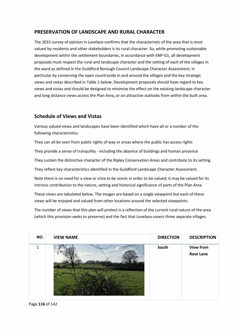
Page 116 of 142
PRESERVATION OF LANDSCAPE AND RURAL CHARACTER
The 2015 survey of opinion in Lovelace confirms that the characteristic of the area that is most
valued by residents and other stakeholders is its rural character. So, while promoting sustainable
development within the settlement boundaries, in accordance with ENP-G1, all development
proposals must respect the rural and landscape character and the setting of each of the villages in
the ward as defined in the Guildford Borough Council Landscape Character Assessment; in
particular by conserving the open countryside in and around the villages and the key strategic
views and vistas described in Table 1 below. Development proposals should have regard to key
views and vistas and should be designed to minimise the effect on the existing landscape character
and long distance views across the Plan Area, or on attractive outlooks from within the built area.
Schedule of Views and Vistas
Various valued views and landscapes have been identified which have all or a number of the
following characteristics:
They can all be seen from public rights of way or areas where the public has access rights
They provide a sense of tranquility - including the absence of buildings and human presence
They sustain the distinctive character of the Ripley Conservation Areas and contribute to its setting
They reflect key characteristics identified in the Guildford Landscape Character Assessment.
Note there is no need for a view or vista to be scenic in order to be valued; it may be valued for its
intrinsic contribution to the nature, setting and historical significance of parts of the Plan Area.
These views are tabulated below. The images are based on a single viewpoint but each of these
views will be enjoyed and valued from other locations around the selected viewpoints.
The number of views that this plan will protect is a reflection of the current rural nature of the area
(which this provision seeks to preserve) and the fact that Lovelace covers three separate villages.
NO. VIEW NAME DIRECTION DESCRIPTION
1
South View from
Rose Lane

Page 117 of 142
2
North View from
Rose Lane
3
South View from
Rose Lane
bridge over A3
4
North View from
Grove Heath
Rd bridge over
A3
5
West View from
Portsmouth
Road at the
Farm Shop
6
Southeast From
Portsmouth
Rd at
Southern
entrance to
Ripley village.

Page 118 of 142
7
South View from
Newark Lane
at the western
entrance to
Ripley village.
8
West View of part
of Ripley
Green closest
to habitation.
9
South View across
Papercourt
Lake
10
North-east Devonia Farm
from Newark
Lane at
entrance to
Ripley village
11
South View from
Newark Lane
between
Georgelands
and
Papercourt
Lake.

Page 119 of 142
12
North-east Homelands
Farm from
Newark Lane
13
South-east View from the
Ripley Nature
Reserve
14
North View from the
western
entrance to
Ockham.
15
North View from Old
Vicarage Lane.

Page 120 of 142
16
South-east View from
Ockham Rd,
Guileshill Lane
junction.
17
South-east View from
School Lane,
Ockham,
towards East
Horsley
18
North View from
School Lane,
Ockham,
facing Bridge
End
19
North View from
Ockham Rd
North,
towards
Martyrs Green

Page 121 of 142
20
South-east View from
Martyrs
Green,
Ockham,
towards
Horsley
21
North-east View from
Mays Green,
Old Lane,
Ockham,
towards
Fetcham
22
East Bridge End
Lane, Ockham,
towards
Effingham
23
East Elm Lane
Ockham. View
across Three
Farms
Meadow

Page 122 of 142
24
South Elm Lane
Ockham. View
across Three
Farms
Meadow
25
North-west Wisley Lane
entrance to
Wisley village
Page 123 of 142
4.4. Biodiversity – Ockham and Wisley Commons

Page 124 of 142

Page 125 of 142

Page 126 of 142
APPENDIX 5 INFRASTRUCTURE
1.1 Public Transport – Three Farms Meadows
The bus service from the TFM to Woking has been removed from the GBC 2017 Draft Local Plan.

Page 127 of 142
APPENDIX 6 GLOSSARY Affordable
Housing
Housing, whether for rent, shared ownership or outright purchase, provided
at a cost considered affordable in relation to incomes that are average or
below average, or in relation to the price of general market housing.
?????????????? International, national and locally designated sites of importance for
biodiversity: All international sites (Special Areas of Conservation, Special
Protection Areas, and Ramsar sites), national sites (Sites of Special Scientific
Interest) and locally designated sites including Local Wildlife Sites.
Air Quality
Management
Areas [NPPF]
Areas designated by local authorities because they are not likely to achieve
national air quality objectives by the relevant deadlines.
Ancient woodland
- [NPPF]
An area that has been wooded continuously since at least 1600 AD
Best and most
versatile
agricultural land
Land in grades 1, 2 and 3a of the Agricultural Land Classification
Birds and Habitats
Directives
European Directives to conserve natural habitats and wild fauna and flora
Brownfield Land See ‘Previously Developed Land’
Blue Corridors Linked to water e.g. watercourses, pools, ponds and pond systems, rivers,
canals, etc
Commercial
Premises [NPPF]
Defined as shops, offices, light industrial, hospitality, schools, surgeries,
leisure facilities, agricultural and horticultural linked businesses and all
businesses using buildings of any type.
Community
Infrastructure Levy
[NPPF]
(CIL) formerly S106 A levy allowing local authorities to raise funds from
owners or developers of land undertaking new building projects in their area.
CIL can be used to help fund projects related to the project. 25% of the levy is
given to the parish in which the development takes palce.
Community Right
to Build Order
[NPPF]
An Order made by the local planning authority (under the Town and Country
Planning Act 1990) that grants planning permission for a site-specific
development proposal or classes of development
Conservation (for
heritage policy)
The process of maintaining and managing change to a heritage asset in a way
that sustains and, where appropriate, enhances its significance.
Conservation Area
Appraisal
???????????
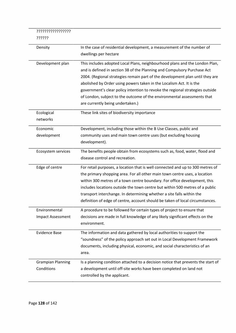
Page 128 of 142
?????????????????
??????
Density In the case of residential development, a measurement of the number of
dwellings per hectare
Development plan This includes adopted Local Plans, neighbourhood plans and the London Plan,
and is defined in section 38 of the Planning and Compulsory Purchase Act
2004. (Regional strategies remain part of the development plan until they are
abolished by Order using powers taken in the Localism Act. It is the
government’s clear policy intention to revoke the regional strategies outside
of London, subject to the outcome of the environmental assessments that
are currently being undertaken.)
Ecological
networks
These link sites of biodiversity importance
Economic
development
Development, including those within the B Use Classes, public and
community uses and main town centre uses (but excluding housing
development).
Ecosystem services The benefits people obtain from ecosystems such as, food, water, flood and
disease control and recreation.
Edge of centre For retail purposes, a location that is well connected and up to 300 metres of
the primary shopping area. For all other main town centre uses, a location
within 300 metres of a town centre boundary. For office development, this
includes locations outside the town centre but within 500 metres of a public
transport interchange. In determining whether a site falls within the
definition of edge of centre, account should be taken of local circumstances.
Environmental
Impact Assessment
A procedure to be followed for certain types of project to ensure that
decisions are made in full knowledge of any likely significant effects on the
environment.
Evidence Base The information and data gathered by local authorities to support the
“soundness” of the policy approach set out in Local Development Framework
documents, including physical, economic, and social characteristics of an
area.
Grampian Planning
Conditions
Is a planning condition attached to a decision notice that prevents the start of
a development until off-site works have been completed on land not
controlled by the applicant.

Page 129 of 142
Green Belt
A designation for land around certain cities and towns, which aims to keep
this land permanently open or largely undeveloped. The purposes of the
Green Belt are to:
• check the unrestricted sprawl of large built up areas
• prevent neighbouring towns from merging
• safeguard the countryside from encroachment
• preserve the setting and special character of historic towns
• assist urban regeneration by encouraging the recycling of derelict and
other urban land
Green Belts are defined in a local planning authority’s Development Plan
Green Corridors
Covering hedgerows, copses, bushes, orchards, woodlands, natural
grasslands and ecological parks.
for visitors
Green Field Land (or a defined site), usually farmland, that has not previously been
developed
Green
infrastructure
A network of multi-functional green space, urban and rural, which is capable
of delivering a wide range of environmental and quality of life benefits for
local communities.
Heritage asset A building, monument, site, place, area or landscape identified as having a
degree of significance meriting consideration in planning decisions, because
of its heritage interest. Heritage asset includes designated heritage assets
and assets identified by the local planning authority (including local listing).
Historic
environment
All aspects of the environment resulting from the interaction between people
and places through time, including all surviving physical remains of past
human activity, whether visible, buried or submerged, and landscaped and
planted or managed flora
Inclusive design
Designing the built environment, including buildings and their surrounding
spaces, to ensure that they can be accessed and used by everyone
Infilling Land with houses or development on three sides
Insetting Removing land or villages from the Green Belt
Land Availability
Assessment
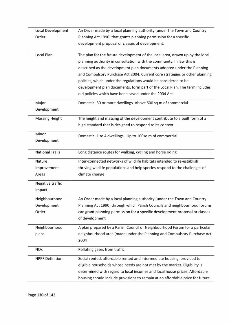
Page 130 of 142
Local Development
Order
An Order made by a local planning authority (under the Town and Country
Planning Act 1990) that grants planning permission for a specific
development proposal or classes of development.
Local Plan The plan for the future development of the local area, drawn up by the local
planning authority in consultation with the community. In law this is
described as the development plan documents adopted under the Planning
and Compulsory Purchase Act 2004. Current core strategies or other planning
policies, which under the regulations would be considered to be
development plan documents, form part of the Local Plan. The term includes
old policies which have been saved under the 2004 Act.
Major
Development
Domestic: 30 or more dwellings. Above 500 sq m of commercial.
Massing Height The height and massing of the development contribute to a built form of a
high standard that is designed to respond to its context
Minor
Development Domestic: 1 to 4 dwellings. Up to 100sq m of commercial
National Trails Long distance routes for walking, cycling and horse riding
Nature
Improvement
Areas
Inter-connected networks of wildlife habitats intended to re-establish
thriving wildlife populations and help species respond to the challenges of
climate change
Negative traffic
Impact
Neighbourhood
Development
Order
An Order made by a local planning authority (under the Town and Country
Planning Act 1990) through which Parish Councils and neighbourhood forums
can grant planning permission for a specific development proposal or classes
of development
Neighbourhood
plans
A plan prepared by a Parish Council or Neighbourhood Forum for a particular
neighbourhood area (made under the Planning and Compulsory Purchase Act
2004
NOx Polluting gases from traffic
NPPF Definition: Social rented, affordable rented and intermediate housing, provided to
eligible households whose needs are not met by the market. Eligibility is
determined with regard to local incomes and local house prices. Affordable
housing should include provisions to remain at an affordable price for future
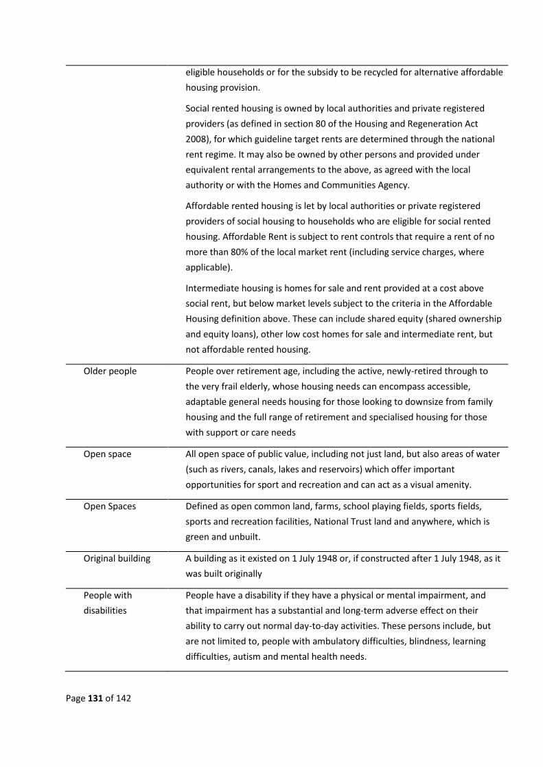
Page 131 of 142
eligible households or for the subsidy to be recycled for alternative affordable
housing provision.
Social rented housing is owned by local authorities and private registered
providers (as defined in section 80 of the Housing and Regeneration Act
2008), for which guideline target rents are determined through the national
rent regime. It may also be owned by other persons and provided under
equivalent rental arrangements to the above, as agreed with the local
authority or with the Homes and Communities Agency.
Affordable rented housing is let by local authorities or private registered
providers of social housing to households who are eligible for social rented
housing. Affordable Rent is subject to rent controls that require a rent of no
more than 80% of the local market rent (including service charges, where
applicable).
Intermediate housing is homes for sale and rent provided at a cost above
social rent, but below market levels subject to the criteria in the Affordable
Housing definition above. These can include shared equity (shared ownership
and equity loans), other low cost homes for sale and intermediate rent, but
not affordable rented housing.
Older people People over retirement age, including the active, newly-retired through to
the very frail elderly, whose housing needs can encompass accessible,
adaptable general needs housing for those looking to downsize from family
housing and the full range of retirement and specialised housing for those
with support or care needs
Open space All open space of public value, including not just land, but also areas of water
(such as rivers, canals, lakes and reservoirs) which offer important
opportunities for sport and recreation and can act as a visual amenity.
Open Spaces Defined as open common land, farms, school playing fields, sports fields,
sports and recreation facilities, National Trust land and anywhere, which is
green and unbuilt.
Original building A building as it existed on 1 July 1948 or, if constructed after 1 July 1948, as it
was built originally
People with
disabilities
People have a disability if they have a physical or mental impairment, and
that impairment has a substantial and long-term adverse effect on their
ability to carry out normal day-to-day activities. These persons include, but
are not limited to, people with ambulatory difficulties, blindness, learning
difficulties, autism and mental health needs.

Page 132 of 142
Planning condition
A condition imposed on a grant of planning permission (in accordance with
the Town and Country Planning Act 1990) or a condition included in a Local
Development Order or Neighbourhood Development Order.
Planning obligation A legally enforceable obligation entered into under section 106 of the Town
and Country Planning Act 1990 to mitigate the impacts of a development
proposal
Playing field The whole of a site which encompasses at least one playing pitch as defined
in the Town and Country Planning (Development Management Procedure)
(England) Order 2010.
PM 2.5/10 Polluting particles, usually from traffic
Pollution Anything that affects the quality of land, air, water or soils, which might lead
to an adverse impact on human health, the natural environment or general
amenity. Pollution can arise from a range of emissions, including smoke,
fumes, gases, dust, steam, odour, noise and light
Previously
developed land
(Brownfield)
Land which is or was occupied by a permanent structure, including the
curtilage of the developed land (although it should not be assumed that the
whole of the curtilage should be developed) and any associated fixed surface
infrastructure. This excludes: land that is or has been occupied by agricultural
or forestry buildings; land that has been developed for minerals extraction or
waste disposal by landfill purposes where provision for restoration has been
made through development control procedures; land in built-up areas such
as private residential gardens, parks, recreation grounds and allotments; and
land that was previously-developed but where the remains of the permanent
structure or fixed surface structure have blended into the landscape in the
process of time.
Primary and
secondary
frontages
Primary frontages are likely to include a high proportion of retail uses which
may include food, drinks, clothing and household goods. Secondary frontages
provide greater opportunities for a diversity of uses such as restaurants,
cinemas and businesses.
Primary shopping
area
Defined area where retail development is concentrated (generally comprising
the primary and those secondary frontages which are adjoining and closely
related to the primary shopping frontage).
Priority habitats
and species
Species and Habitats of Principle Importance included in the England
Biodiversity List published by the Secretary of State under section 41 of the
Natural Environment and Rural Communities Act 2006.

Page 133 of 142
Rural Exception
Homes
(Definition taken from GBC’s website -
https://getinvolved.guildford.gov.uk/consult.ti/LPSS2016/view?objectId=7810004)
• Affordable homes for people who cannot afford to rent or buy and
have connections to rural parishes through family, recent past
residence, or current employment. Such housing must be retained
permanently for people who are current or former residents, or who
have a family or employment connection to the parish.
• As an exception to other development plan policies including Green
Belt policy, these are affordable houses provided on small sites in
rural areas on Green Belt land.
• Sustainable
Rural exception
sites
Small sites used for affordable housing in perpetuity where sites would not
normally be used for housing. Rural exception sites seek to address the needs
of the local community by accommodating households who are either
current residents or have an existing family or employment connection. Small
numbers of market homes may be allowed at the local authority’s discretion,
for example where essential to enable the delivery of affordable units
without grant funding
Safeguarding zone An area defined in Circular 01/03: Safeguarding aerodromes, technical sites
and military explosives storage areas, to safeguard such sites
Section 106
Monies
Setting of a
heritage asset
The surroundings in which a heritage asset is experienced. Its extent is not
fixed and may change as the asset and its surroundings evolve. Elements of a
setting may make a positive or negative contribution to the significance of an
asset, may affect the ability to appreciate that significance or may be neutral.
Settlement Areas
Severe Traffic
impact
This means the road usage will exceed the capacity as stated in the Design
Manual for Roads and Bridges for that designation of road.
Significance (for
heritage policy)
The value of a heritage asset to this and future generations because of its
heritage interest. That interest may be archaeological, architectural, artistic
or historic. Significance derives not only from a heritage asset’s physical
presence, but also from its setting
Significant
Development
Domestic: 5 or more dwellings. Above 100 sq. m of commercial

Page 134 of 142
Significant
Negative Impacts
(Traffic)
This means that the level of traffic increases Air and Noise pollution above
the level set by the controlling bodies within the UK and Internationally
Site investigation
information
Includes a risk assessment of land potentially affected by contamination, or
ground stability and slope stability reports, as appropriate. All investigations
of land potentially affected by contamination should be carried out in
accordance with established procedures (such as BS10175 (2001) Code of
Practice for the Investigation of Potentially Contaminated Sites). The
minimum information that should be provided by an applicant is the report
of a desk study and site reconnaissance.
Site of Special
Scientific Interest
Sites designated by Natural England under the Wildlife and Countryside Act
1981
Special Areas of
Conservation
Areas given special protection under the European Union’s Habitats Directive,
which is transposed into UK law by the Habitats and Conservation of Species
Regulations 2010.
Special Protection
Areas
Areas which have been identified as being of international importance for the
breeding, feeding, wintering or the migration of rare and vulnerable species
of birds found within European Union countries. They are European
designated sites, classified under the Birds Directive.
Stepping stones Pockets of habitat that, while not necessarily connected, facilitate the
movement of species across otherwise inhospitable landscapes
Strategic
Environmental
Assessment
A procedure (set out in the Environmental Assessment of Plans and
Programmes Regulations 2004) which requires the formal environmental
assessment of certain plans and programmes which are likely to have
significant effects on the environment
Strategic Road
Network
Sustainable
transport modes
Any efficient, safe and accessible means of transport with overall low impact
on the environment, including walking and cycling, low and ultra low
emission vehicles to reduce carbon emissions, car sharing and public
transport to reduce pressure on other infrastructure such as the transport
network
Town centre
Area defined on the local authority’s proposal map, including the primary
shopping area and areas predominantly occupied by main town centre uses
within or adjacent to the primary shopping area. References to town centres
or centres apply to city centres, town centres, district centres and local
centres but exclude small parades of shops of purely neighbourhood

Page 135 of 142
significance. Unless they are identified as centres in Local Plans, existing out-
of-centre developments, comprising or including main town centre uses, do
not constitute town centres
Transport
assessment
A comprehensive and systematic process that sets out transport issues
relating to a proposed development. It identifies what measures will be
required to improve accessibility and safety for all modes of travel,
particularly for alternatives to the car such as walking, cycling and public
transport and what measures will need to be taken to deal with the
anticipated transport impacts of the development.
Transport
statement
A simplified version of a transport assessment where it is agreed the
transport issues arising out of development proposals are limited and a full
transport assessment is not required.
Travel plan A long-term management strategy for an organisation or site that seeks to
deliver sustainable transport objectives through action and is articulated in a
document that is regularly reviewed.
Wildlife corridor Areas of habitat connecting wildlife populations.
Windfall sites Sites which have not been specifically identified as available in the Local Plan
process. They normally comprise previously-developed sites that have
unexpectedly become available

Page 136 of 142
REFERENCES (n.d.).
Guildford Borough Council - RHS Planning Application No 16/P/01080. (2016, September 30). Planning.
Retrieved from Guildford Borough Council:
http://www2.guildford.gov.uk/publicaccess/files/AED04D51ECF150CDB9C300BBD748476E/pd
f/16_P_01080-DECISION_NOTICE-969651.pdf
AECOM. (2017, June). Sustainability Appraisal of the Guildford Borough Local Plan. Retrieved from
Guildford Borough Cuoncil:
http://www.guildford.gov.uk/newlocalplan/CHttpHandler.ashx?id=24623&p=0
AECOM. (2017, June). Sustainability Appraisal of the Guildford Borough Local Plan. Retrieved from
Guildford Borough Council:
http://www.guildford.gov.uk/newlocalplan/CHttpHandler.ashx?id=24623&p=0
Appendix ..... - AECOM - Lovelace Neighbourhood Development Plan Review, pg 22 - Evidence
Analysis. (2018). Lovelace Neighbourhood Development Plan. AECOM.
Appendix ...... - AECOM Lovelace Neighbourhood Development Plan - pg 22, Conformity Check. (2018).
Lovelace Neighbourhood Developent Plan. AECOM.
Arriva. (n.d.). 463 - 462 Bus Timetable. Retrieved from Arriva Kent and Surrey:
https://bustimes.org/services/463-guildford-ripley-woking
ARUP. (2013). Surrey Rail Strategy - Executive Summary. Retrieved from Surrey County Council:
https://mycouncil.surreycc.gov.uk/documents/s6303/19%2006%202013%20Item%207%20An
x%201%20Surrey-Rail-Strategy-Report-ExecSum-final.pdf
DEFRA. (n.d.). UK and EU Air Quality Policy Context. Retrieved from DEFRA: https://uk-
air.defra.gov.uk/air-pollution/uk-eu-policy-context
Department for Environment, Food and RuralAffairs. (2011). A Strateegy for England's Wildlife and
Ecosystem Services. Retrieved from Biodiversity 2020:
(https://assets.publishing.service.gov.uk/government/uploads/system/uploads/attachment_d
ata/file/69446/pb13583-biodiversity-strategy-2020-111111.pdf
Dept for Transport, Pg 110. (n.d.). Manual for Streets. Retrieved from
https://assets.publishing.service.gov.uk/government/uploads/system/uploads/attachment_d
ata/file/341513/pdfmanforstreets.pdf
Dept. for Transport. (2007). Manual for Streets, pg 71, 6.4.5. Thomas Telford Ltd.
European Parliament. (2008). Directive of 2008/50/EC - on ambient air quality and cleaner air for
Europe. Retrieved from fficial Journal of the European Untion: http://eur-
lex.europa.eu/LexUriServ/LexUriServ.do?uri=OJ:L:2008:152:0001:0044:EN:PDF

Page 137 of 142
Forestry Commission and Natural England. (n.d.). Ancient Woodland - Protecting them from
development . Retrieved from Gov.uk: https://www.gov.uk/guidance/ancient-woodland-and-
veteran-trees-protection-surveys-licences#ancient-woodland
Former Wisley Airfield Inquiry - pg 119, item 22.7. (2018, June 13). Guldford Borough Council Appeal
by Wisley Property Investments Ltd. Retrieved from
https://assets.publishing.service.gov.uk/government/uploads/system/uploads/attachment_d
ata/file/715777/18-06-13_DL_IR_Wisley_Airfield_3159894.pdf
Former Wisley Airfield Inquiry Report - pg 122, i. 2. (2018, June 13). Former Wisley Inquiry Report.
Retrieved from Ministry of Housing, Communities & Local Government:
https://assets.publishing.service.gov.uk/government/uploads/system/uploads/attachment_d
ata/file/715777/18-06-13_DL_IR_Wisley_Airfield_3159894.pdf
GBC - Air Quality Duties. (2018). Air Quality Monitoring. Retrieved from
https://www.guildford.gov.uk/article/19807/Air-quality-monitoring
GBC Planning Applications - The Drift Routing Plan Map, pg 5. (2014, March 4). Planning Applictions .
Retrieved from Guildford Borough Council:
http://www2.guildford.gov.uk/publicaccess/files/92211D032C655FB6E0F1340DB3224140/pdf
/13_S_00003-ENQUIRY__2_-689320.pdf
Guildford Borough Council - 15/P/00012 Refusal . (2016, April 8). 15/P/00012 Decsion Notice.
Retrieved from Guildford Borough Council:
http://www2.guildford.gov.uk/publicaccess/files/56733CFA1259CECA16C77451E3A410BD/pdf
/15_P_00012-DECISION_NOTICE-914903.pdf
Guildford Borough Council - 2017 Local Plan Examination. (2018, June). Local Plan Examination -
Submission of Local Plan (Reg 22). Retrieved from Guildford Borough Council:
https://www.guildford.gov.uk/newlocalplan/examination
Guildford Borough Council - draft LP Consultation Document - pg 225-6, i. 6. (2017, June). Guildford
borough Proposed Submission Local Plan: strategy and sites. Retrieved from Guildford
Borough Council:
https://www.guildford.gov.uk/newlocalplan/CHttpHandler.ashx?id=24628&p=0
Guildford Borough Council - Local Plan 2017 - Homes for All, pg 31, 4.2.3. (2017, December).
Submission Local Plan: Strategy and Sites. Retrieved from
https://www.guildford.gov.uk/newlocalplan/CHttpHandler.ashx?id=26746&p=0
Guildford Borough Council - Policy A35, Infrastructure, point 6. (2018, July-August). Proposed
Submission Local Plan: strategy and sites 2017 - Part 2: Sites: POLICY A35: Former Wisley
airfield, Ockham. Retrieved from Guildford Borough Council:
https://getinvolved.guildford.gov.uk/consult.ti/pslpss17/viewCompoundDoc?docid=8815252
&sessionid=&voteid=&partId=8819476

Page 138 of 142
Guildford Borough Council - Policy A43, Garlicks Arch. (2018, July-August). Proposed Submission Local
Plan: strategy and sites 2017 - Part 2: Sites: POLICY A43 Land at Garlick’s Arch, Send
Marsh/Burnt Common and Ripley. Retrieved from Guildford Borough Council:
https://getinvolved.guildford.gov.uk/consult.ti/pslpss17/viewCompoundDoc?docid=8815252
&sessionid=&voteid=&partId=8819988
Guildford Borough Council - Policy A43a, S. R. (2018, July-August). Proposed Submission Local Plan:
strategy and sites 2017 - Part 2: Sites: POLICY A43a: Land for new north facing slip roads
to/from A3 at Send Marsh/Burnt Common. Retrieved from Guildford Borough Council:
https://getinvolved.guildford.gov.uk/consult.ti/pslpss17/viewCompoundDoc?docid=8815252
&sessionid=&voteid=&partId=8820052
Guildford Borough Council - Policy A58, B. C. (2018, July-August). Proposed Submission Local Plan:
strategy and sites 2017 - Part 2: Sites: POLICY A58: Land around Burnt Common warehouse,
London Road, Send. Retrieved from Guildford Borough Council:
https://getinvolved.guildford.gov.uk/consult.ti/pslpss17/viewCompoundDoc?docid=8815252
&sessionid=&voteid=&partId=8820372
Guildford Borough Council - Ripley Conservation Area Appraisal. (2017, July). Conservation Area
Character Appraisals. Retrieved from Guildford Borough Council:
https://www.guildford.gov.uk/article/16933/Conservation-Area-Character-Appraisals
Guildford Borough Council - The Drift Planning Application No. 14/P/01718. (2014, March 14).
Planning Applications - The Drift Golf Club. Retrieved from Guildford Borough Council:
http://www2.guildford.gov.uk/publicaccess/files/F40A5530A7525ACF61600C76071DB1A0/pd
f/13_S_00003-ENQUIRY__1_-689311.pdf
Guildford Borough Council. (2017, December). Guildford Borough Transport Strategy - Page 3.
Retrieved from Guildford Borough Council New Local Plan:
http://www.guildford.gov.uk/newlocalplan/CHttpHandler.ashx?id=26649&p=0
Guildford Borough Council. (2017). Land Availabile Assessment (LAA) - Appendix B. (Sites 229 (ref.
2055); 335 (Ref 1582); 338 (ref. 2366)' 394 (ref. 2258); 384 (ref. 53 & 54)). Retrieved from GBC
Brownfield Land Register, Part 2 :
http://www.guildford.gov.uk/newlocalplan/CHttpHandler.ashx?id=26604&p=0
Guildford Borough Council. (2017, July). Ripley Conservation Area Appraisal. Retrieved from Guildford
Borough Council:
file:///C:/Users/Annie/AppData/Local/Packages/Microsoft.MicrosoftEdge_8wekyb3d8bbwe/T
empState/Downloads/Ripley_CAA_July_2017_reduced_file_(2)_FINAL_FOR_WEB.pdf
Guildford Borough Council. (2018, April). Local Housing Allowance. Retrieved from Guildford Borough
Council: https://www.guildford.gov.uk/localhousingallowance

Page 139 of 142
Guildford Borough Council and Ptarmigan Land - Statement of Common Ground, p. 3. (2018, July 3).
Statement of Common Ground - GBC and Ptarmigan re: Site A43. Retrieved from
http://www.guildford.gov.uk/newlocalplan/CHttpHandler.ashx?id=28106&p=0
Guildford Borough Council. (n.d.). Brownfield Land Register. Retrieved from Guildford Borough Council
: https://www.guildford.gov.uk/planningpolicy/brownfield-land-register
Guildford Borough Council. (n.d.). Landscape Character Asssessment. Retrieved from Guildford
Borough Council: https://www.guildford.gov.uk/landsapecharacterassessment
Guildford Borough Council. (n.d.). Our Vision and Ambition: Spatial Vision - Pg 19. Retrieved from
Guildford Borough Submission Local Plan: Strategy & Sites:
http://www.guildford.gov.uk/newlocalplan/CHttpHandler.ashx?id=26746&p=0
Highways England - M25 Junction 10 / A3 Wisley Interchange. (2018, February 12). M25 junction
10/A3 Wisley interchange improvement scheme. Retrieved from Highways England:
https://highwaysengland.citizenspace.com/he/m25-junction-10-a3-wisley-interchange-
2018/supporting_documents/GFD18_0011%20M25%20Junction%2010%20consultation%20%
20brochure%20V11.pdf
Homelet. (2018, February). Homlet. Retrieved from https://homelet.co.uk/news
Lancaster University Work Foundation. (2016, February). Working (am to 5pm no longer "the way to
make a living". 'Working Anywhere, A Winning Formula for Good Work'. Retrieved from
http://www.lancaster.ac.uk/news/articles/2016/working-9am-5pm-no-longer-the-way-to-
make-a-living/
Lawton, S. J. (2010). Making Space for Nature. Retrieved from National Archives:
http://webarchive.nationalarchives.gov.uk/20130402170324/http://archive.defra.gov.uk/envi
ronment/biodiversity/documents/201009space-for-nature.pdf)
Legislation.gov.uk. (n.d.). The Air Quality Standards Regulations UK . Retrieved from Legislation.gov.uk:
http://www.legislation.gov.uk/uksi/2010/1001/contents/made
Lovelace NP, H. S.-P. (2016, April). Lovelace Neighbourhood Plan/Surveys. Retrieved from Lovelace
Neighbourhood Plan: http://lovelaceplan.co.uk/survey-form/
Lovelace NP, H. S.-P.-2. (2016, April). Lovelace Neighbourhood Plan Surveys. Retrieved from Lovelace
Neighbourhood Plan: http://lovelaceplan.co.uk/survey-form/
Mike Waite, S. N. (2015). Biodiversity Opportunity Areas: the basis for realising Surrey’s ecological
network . Retrieved from Surrey Nature Partnership:
https://surreynaturepartnership.files.wordpress.com/2014/11/biodiversity-opportunity-
areas_surrey-nature-partnership_20151.pdf
Ministry of Housing , Communities and Local Governmenet and The Rt Hon Sir Eric Pickles. (n.d.).
Helping Local Shops and Preventing Congestions. Retrieved from Gov.UK:
https://www.gov.uk/government/speeches/planning-update-march-2015

Page 140 of 142
Ministry of Housing, C. a. (2012, March). National Planning Policy Framework, para 89, bullet point 6.
Retrieved from Gov.UK:
https://assets.publishing.service.gov.uk/government/uploads/system/uploads/attachment_d
ata/file/6077/2116950.pdf
Ministry of Housing, Communities and Local Government. (2012, March). Conserving and Enhancing
the Natural Environment. Retrieved from Gov.UK: https://www.gov.uk/guidance/national-
planning-policy-framework/11-conserving-and-enhancing-the-natural-environment
Ministry of Housing, Communities and Local Government. (2012). Meeting the challenge of climate
change, flooding. Retrieved from Gov.uk: https://www.gov.uk/guidance/national-planning-
policy-framework/10-meeting-the-challenge-of-climate-change-flooding-and-coastal-change
Ministry of Housing, Communities and Local Government. (2012, March). National Planning Policy
Framework, para 38. Retrieved from Gov.UK: https://www.gov.uk/guidance/national-
planning-policy-framework/4-promoting-sustainable-transport.
Ministry of Housing, Communities and Local Government. (2014, March). Light Pollution. Retrieved
from Gov.uk: https://www.gov.uk/guidance/light-pollution#possible-ecological-impact
Ministry of Housing, Communities and Local Government. (2018, March). Chapter 5: Deliverying a
wide choice of quality homes. Pg 13, paras 66-67. Retrieved from NPPF Consultation
Proposals:
https://assets.publishing.service.gov.uk/government/uploads/system/uploads/attachment_d
ata/file/685288/NPPF_Consultation.pdf
Ministry of Housing, Communities and Local Government. (2018, March). Planning for the Right
Homes in the Right Places. Retrieved from Government response to the Plannng for the right
homes in the right places consultation:
https://assets.publishing.service.gov.uk/government/uploads/system/uploads/attachment_d
ata/file/685293/Government_response_to_Planning_for_the_right_homes_in_the_right_plac
es_consultation.pdf
NPPF - para 100. (2018, July). Open Spaces and Recreation. Retrieved from
file:///E:/LOVELACE%20Neighbourhood%20Plan/2018/LNP%20-
%20CURRENT%20VERSION/NPPF%20-%202018/2018%20-
%20National_Planning_Policy_Framework.pdf
NPPF, paras117, 122, 123. (2018, July). National Planning Policy Framework. Retrieved from
https://assets.publishing.service.gov.uk/government/uploads/system/uploads/attachment_d
ata/file/733637/National_Planning_Policy_Framework_web_accessible_version.pdf
ONS: Census. (2011). Age Finder. Retrieved from Nomis:
https://www.nomisweb.co.uk/census/2011/ks102ew
ONS: Census. (2011). Household Composition. Retrieved from Nomis:
https://www.nomisweb.co.uk/census/2011/ks105ew

Page 141 of 142
ONS: Census. (2011). Household: Cars of Vans. Retrieved from Nomis:
https://www.nomisweb.co.uk/census/2011/ks404ew
Planning Inspectorate - 18-06-13 DL+IR Wisley Airfield 3159894.pdf. (2018, June 13). 18-06-13 DL+IR
Wisley Airfield 3159894.pdf. Retrieved from
https://acp.planninginspectorate.gov.uk/ViewCase.aspx?caseid=3159894
Ripley Parish Council. (2018, April 19). Meeting Archive 2018. Retrieved from Ripley Parish Council:
http://www.ripleyparishcouncil.gov.uk/meetings_archive_2018.html
Royal Commission on Environmental Pollution. (2009). Artificial Light in the Environment. Retrieved
from Gov.UK: https://www.gov.uk/guidance/light-pollution
SLGA Surrey Design 2002. (2002). Retrieved from
https://www.surreycc.gov.uk/__data/assets/pdf_file/0008/66887/Surrey-Design.pdf).
Solilhull Borough Council. (n.d.). Dickens Heath History. Retrieved from Solihull.gov.uk:
http://www.solihull.gov.uk/Resident/Libraries/Local-family-
history/localhistory/dickensheathhistory
Stagecoach. (2017, September). 715 Bus Timetable. Retrieved from Stagecoach: https://tiscon-maps-
stagecoachbus.s3.amazonaws.com/Timetables/South/Guildford/GD715Timetable02Sep17.pdf
Surrey Countryside and Rural Enterprise Forum. (2015). A Rural Statement for Surrey. Retrieved from
https://issuu.com/surreycountycouncil/docs/cs3260_scref_surrey_rural_strategy_/7
Surrey County Council - Planning No. 2014/0150. (2016, December 7). Retrieved from Planninig:
https://planning.surreycc.gov.uk/planapplist.aspx
Surrey County Council. (2002). Retrieved from SLGA Surrey Design:
https://www.surreycc.gov.uk/__data/assets/pdf_file/0008/66887/Surrey-Design.pdf
Surrey Nature Partnership. (2014, May). Biodiversity and Planning in Surrey. Retrieved from Surrey
Nature Partnership: https://surreynaturepartnership.org.uk/our-work/
Surrey Wildlife Trust. (2014). Living Landscapes Strategy. Retrieved from Surrey Wildlife Trust:
https://www.surreywildlifetrust.org/sites/default/files/sywt_living_landscape_strategy_2014.
Surrey Wildlife Trust. (n.d.). A Living Landscape for Surrey. Retrieved from Surrey Wildlife Trust:
https://www.surreywildlifetrust.org/sites/default/files/a_living_landscape_for_surrey_low_re
s.pdf
Surrey Wildlife Trust. (n.d.). Living Landscapes: Restore, Recreate, Reconnect. Retrieved from Surrey
Wildlife Trust:
https://www.surreywildlifetrust.org/sites/default/files/a_living_landscape_for_surrey_low_re
s.pdf
TRL Consultants (TRL). (n.d.). Retrieved from https://trl.co.uk/
Page 142 of 142
Waite, M. (2015, December). BOAs - Appendix 4: Thames Basin Heaths Biodiversity Opportunity Area
Policy Statements. Retrieved from Surrey Nature Partnership:
https://surreynaturepartnership.files.wordpress.com/2014/11/appendix-4_thames-basin-
heaths-biodiversity-opportunity-area-policy-statements.pdf
Waite, M. (2015, December). BOAs - Appendix 5: Thames Basin Lowlands . Retrieved from Surrey
Nature Partnership: https://surreynaturepartnership.files.wordpress.com/2014/11/appendix-
5_thames-basin-lowlands-biodiversity-opportunity-area-policy-statements.pdf
Waite, M. (2015, December). BOAs - Appendix 9: River Biodiversity Opportunity Area Policy
Statements. Retrieved from Surrey Nature Partnership:
https://surreynaturepartnership.files.wordpress.com/2014/11/appendix-9_river-biodiversity-
opportunity-area-policy-statements-maps-tba1.pdf