Embed Size (px)
Citation preview

A COMPREHENSIVE PLAN
BOROUGH OF RIVERSIDE
Northumberland County, Pennsylvania
1962
Clifton E . Rodgers and Associates City Planners, Engineers, Landscape Architects
Harrisburg, Pennsylvania
During the praparation of this Repor t , many organizations, both governmental and private, as well as individual citizens, provided helpful information and sug- gestions to our staff, We wish to express our thanks to these many persons and organizations.
Acknowledgment is made to the following:
Urban Renewal Administration Housing and Home Finance Agency Bureau of Community Development Pennsylvania Department of Commerce
This planning project was financed in part through an Urban Planning Grant from the Housing and Home Finance Agency, under the provisions of Section 701 of the Housing Act of 1954, as amended.

I ! I I.
1 I I I
la 1 I
BOROUGCI OFFICIALS
Frank C . IVebber, Mayor
Borough Council
George G . Myerley , President Sue1 C. Bailey Edward S. Jones Robert Leedy Charles W. Rechsteiner Percy G. Schuck Harry J . Hummel
Jesse S, Gulick, Secretary Arthur M. Peters, Jr., Solicitor John S . Jacobs 8 Borough .Engineer
Planninrr Commission
Harold E. Fisher, Chairman Charles T , Campbell, Secretary J. Elliott Bird Edward F, Johnson Paul D . Reichenbach
Sewer Authority
William T , Deeter, Chairman John H . Gaskins . George B , Creasy Dr. I . L. Messmore Paul Reichenbach

PLANNIXG STAFF
Planning Cons ul'iant
Clifton E. Eodgers
Associate Consultants
Norman H. Mazurie G , Clifford Terbush
Planning Staff
Robert B. Donaldson Thomas E . Xratosky Joan Landy, Secretary

TABLE 0 F CONTENTS
I ' HISTORY .................................................... PHYSIOGRAPHY .............................................. ECONOMY .................................................. POPULATION AND HOUSING ................................... EXISTING LAND USE ......................................... . .
EXISTING COMMUNITY FACILITIES .......................... i .. MUNICIPAL FINANCES ....................................... MAJOR THOROUGHFARE PLAN .................................. FUTURE LAND USE PLAN ....................................... PROPOSED COMMUNITY FACILITIES ............................ PUBLJC IMPROVEMENT PROGRAM .............................. ADMINISTRATION .....................................:......
Page
1
5
8
16
22
29
36
43
52
56
63
69
0
I I
I I 1 I I IO I 1 1 I I I I El I
a
Plate No.
1 2 3 4 5 6 7 8 9 10 I1 12 13
LIST OF PLATES
Topography Existing Development Population Growth, 1890-1S80 Population Distribution Existing Land Use School Enrollment Trends Sewer System Income and Expenditures Traffic Volume Flow Major Thoroughfares Road Cross Sections Future Land Use Plan Community Facilities
Follows Page
6 13 17 19 25 30 34 39 46 48 50 53 57
LIST OF TABLES
Table No.
1 2 3 4 5 6 7 8 9
10 11 12 13 14 15
Distribution of Labor Force by Percent of Employed Distribution of Labor Force by Industry Group Retail Sales Trends Retail Trade Data Industrial Activity in Northumberland County Comparative Economic Data Comparison of Population Trends Age Composition of the Population Existing Land Use Schodl Enrollment Source of Income Assessed Valuation - Millage and Receipts Operation and Maintenance Expenditures 1955-1960 Capital Outlay Standards for Traffic Lanes
Pase
9 10 11 12 14 15 17 18 26 3 1 36 37 4 1 42 45

HISTORY
As early as 1755, *he part of Pennsylvania bordering the upper branches of ths Susquehanna River was an unbroken wilderness, except for a few piozaer cabins . The marest settlement to the west was Shamokintown, which lay at ths junction of the t w branches of the Susquehanna, where Sunbury now stands. A h i t this same time, King George of England built Fort Augusta at the convergence of the two branches of the river to protect the settlers against the Indians.
A short time prior to the location of the railroad on the southern bank of the Sus@ehnna River in 1868, the desirability of securing land on the opposite side of the river k o m Dsnville attracted the attention of several Danville citizens . Thomas Beaver, Dan Mor~an, I . H. Torrence, and B . G. Welch purchased a part of the Daniel Cameron farm adjoining the Herman Gearhart tract. This tract contained 100 acres of land between the river and Sunbury Road, one-half mile west of the river bridge, which was then a part of Berks County.
In 1868, the land was l a d out in wide avenues and streets with lots 50 by 184 fzet . 0. H Ostsander was appointed Surveyor and Sales Agent for the Land Association .
At th is t ime, bcsiness in Danvflle was very prosperous, with labor in demsnd and wages high. Although the idea of founding a town so new to Donville was cozsidered by m n y as an impractical one, two-thirds of all ths lots were sold within two years . The first dwelling was erected on Avenue D nezr First Street by William Spotts in May 1869 . By 1870, some twenty homes wei-e bulk, m d the need for s c b o l facilities became apparent. A few enterprising citizzas ad-nnced funds to construct a two story brick building at the comer of Avenue E and Fourth Street for the sum of $4600, and rented this buildiag to purchase it.
ScIn31 District until such t ime as they could
Tks derinzzld fcr mOi= lots persuaded William Faux, whose farm was on the west side cf the tmm, to la:( out 30 acres of his land north of Sunbury Road in 1859. In 1870, the izn:rS of Xerman Gearhart, owning land on the enst of the v i l h G e , kiid ogt 50 acres bounded on the south by Sunbury Road, north by the River, and east by tl=e rosd leading to the river bridge. A survey was made and the land vas laid out with streets 50 feet wide on lines running parallel with Sunbury Road, fhe lots being made 50 by 150 feet. T h i s
-1-

arrangement proved to be unwise , because these streets seriously conflicted with the alignment of streets in the original section of town, producing unnecessary offsets and angles. This Gearhart layout was called South Danville .
In the year 1871, the village which lay across the river from Danville was incorporated as a borough and the local post office was estab- lished in the same year.
Building flourished until 1874, when a general paralysis set in on all industrial pursuits, due to the downfall of Jay Cooke, a banker with liabilities of four million dollars , whose failure caused widespread disaster to the whole area.
In 187 1 , John Keim engaged in the manufacture of building bricks #
burning from eight to ten ki lns per year. He continued this plant for several years at its location on Avenue A, adjoining Susquehanna Avenue, until the clay was exhausted.
Many other industries were in evidence at this t i m e also. They included Clement's Lumber Yard , Yeager's Coal Yard , Shuman's Dairy, Sam'l Bailey & Company, Shifner's File Factory, and Cliffe's Nursery. In 1885 the Gulick Sand Company was shipping large quantities of superior moulding sand to stove factories and iron foundries throughout the State. Valuable beds of sand are still found within the boundaries of Riverside.
During the year 1872, a bridge and boiler factory was built by the National Iron Company of Danville. The plant was leased to William H . Law , a master mechanical engineer and bridge builder, until 1874, when he gave up the business due to the economic depression in the area. The plant manufactured boilers, stacks, sheet iron works, and wrought iron bridges which were erected throughout Lehigh, Northumberland and Schuylkill Counties .
In the year 1876, there were within the Borough limits, seventy buildings , a population of 400, and an assessed valuation of $103 , 000.00.
The prosperity which had marked five years of advancement for the new settlements on Yhe south shore suddenly ceased, due to the panic of the Seventies. The people were barely able to meet the necessities of living. As a result, a great number of homes were lost by Sheriff's sales. This period of depression continued for several years, when business began slowly to revive , and re-awaken the spirit of progress and improvement. As the depression was ending, many farmers retired from their farms and purchased or built houses in the iwo villages 8 bringing in new energy and fresh capital,
-2 -

Many who lost their homes were able to regain them at lower prices, population increased, and again began to grow.
About the year 1896, Dr. A. T . DeWitt purchased 28 acres of partially wood land at the southern terminus of E Avenue - a section of the Van Nostran farm. DeVfitt proceeded to turn this into a "pleasure resort" for the public. Many entertainment facilities were built, such as a large pavilion, a cookhouse # swings and play equipment, bicycle trails, a tennis and croquet lawn and a "merry-go-round" at a cost of over $2,000.00.
As stated by a historian in 1876, "The people of Riverside have evidenced commendable taste in the building of their houses and fences, in the planting of many trees and in the general adornment of their grounds. In fact, no town of equal age within the Commonwealth can boast of better or more substantial improvements" .
In the original Riverside area, under a wise provision of the planners, the grantees were required to keep the front line of all buildings 20 feet back from the Avenues, thus creating a broad vista of 100 feet in width between the houses .
The Danville and Sunbury Electric Railroad was charted in 1904 and a right-of-way was secured between Danville and Sunbury. The railroad was constructed between the State Hospital in Mahoning Township to De Witt's Park in Riverside, a distance of two and one half miles, from which point the railroad was to be continued to Sunbury, Bloomsburg and Berwick .
The depression of the 1930's had little effect upon the spirit and determination of the people to forge ahead. All streets were paved and other improvements made.
In 1942 8 U . S . Army Engineers made a survey of lands situated , in part, within the Borough l i m i t s and other lands in Gearhart Township; after the survey was made and approved by Army Ordnance, the Amos Wohltarth farm and lots on First Street west of Avenue E were purchased by the Government. The Cherokee Ordnance Works was built at a cost of many millions of dollars . The plant was operated by Heyden Chemical Company under the direction of the Army until 1946 when it was de-activated. The plant was guarded for the next four years by Army Ordnance.
The year 1950 ushered in a new era in the growth of the two villages. Merck & Co., Inc., of Rakkay, New Jersey, manufacturing chemists, during the early summer, leased from the Government the Cherokee
-3-

0 Ordnance buildings with a purchase option. Since then, many new buildings were erected. During the Fall and Winter of that year, Merck & Co ., Inc . build 18 new houses on Avenue D and F . At this t ime it was discovered that many wells i n the community were contaminated due to excessive disposal .of sewage into sumps , cess -pools and open pits. Merck 6 Co . , Inc . agreed to treat all sewage in the Borough if the Borough would provide the mains through the village and lead them to Cherokee plant.
The Riverside Borough Council appointed five men to form."The Riverside Municipal Authority" and to make a study in order to build the lines if found feasible. The men named were: Dr. Reed Babcock, William E , Booth, William T . Deeter, Edward S. Jones, and Dr. Isaac Messmore. A survey was made and estimates obtained.
During this period of engineering, the people of the village of South Danville asked that sewer lines be extended to certain parts of their village. This imposed a problem in political expediency. To overcome this problem, petitions were presented to Court by the voters of Gearhart Township that they be received into the Borough of Riverside and the Borough boundaries be extended to encompass all of Gearhart. The petitions were approved by Court with the result that the present area of Riverside Borough is over 3500 acres.
During the summer and fall of 1951, over seven miles of sewer mains were laid to serve all of the built-up section of the new Borough. Merck & Co . , Inc. executed an Agreement in which they agreed to treat the sewage, without cost, for a period of 40 years. Sewer Revenue Bonds in the amount of $295,000.00 were sold to pay for the installations, and mature, serially, over a period of 40 years. The Authority has added approximately three quarters of a mile of new mains to serve the new residences which have developed in the Borough.
0
In 1954, the Riverside School Authority was organized to provide for the construction of school facilities to house the increasing number of school children. In 1957 a modern six room Elementary School was construct- ed, and plans are now being prepared to provide three additional classrooms and a library.
To provide additional employment, the Borough Council in 1960 provided at no cost, one half of a plot of land, owned by the Borough of Riverside, to the Lynn Dress Company. This action prevented the moving of this industry to an area outside the Borough.

!
The topography of the Borough is shown on the Plate entitled "Topography". A bowl is formed by the bend in the River on the north, by Kipps Run on *e west, the ridge on the south and by a ridge on the east . Therefore, development has been greatly influenced by the River in the north and the steeply rising topography on the other three sides. The present devel- opment, for the most part, is located in the eastern section of the bowl and occupies only about one-third of the bowl area. The topography at the River is 440 feet above sea level and rises in a gradual slope from the River to an elevation of 560 feet to the south rim of the bowl. West of Kipps Run and south of Sunbury Road, the topography rises rather sharply to an elevation of over 900 feet. This area is for the most part wooded, with a scattering of farms on the level benches of the ridges. The area west of Kipps Run, north of Sunbury Road, is rather low and level with intense farming activities in the area between the Sunbury Road and the River.
I
P Hy Si0 GRAPHY
Northumberland County
Northumberland County is located in the center of the Appalachian Region and is bounded on the west by the Susquehanna River whose two branches unite at Sunbury. The West Branch flows from the north and west, while the North Branch flows through the center of the County, extending north and east toward Wikes-Barre. The picturesque scenery of both land and water is among the most beautiful within the Commonwealth.
The County also enjoys a great diversification of agriculhiral, manufacturing and mining interests, with the western end of the Middle Anthracite Basin located in Northumberland County.
Riverside Borough
The Borough is located on the south bank of the North Branch of the Susquehanna River. The Borough is located on the rather gently sloping land formed by a sweeping bend of the River, just opposite the Borough of Danville . 0
The eastern area of the Borough, south and east of "I" Avenue, rises very sharply again reaching elevation of 900 feet above sea level. Here, as in the western end of the Borough, the area is largely wooded with agricultur- al uses on the level areas on the tops of the ridges.
1
-5-

The Borough, as can be seen on the Plate entitled "Topography" has large areas of very desirable land fot future development. The large area between Borough Line Road on the east and Legislative Route 49043 on the west and between Sunbury Road on the north and Legislative Route 49040 on the south provides an excellent area for future growth. Too 8 the area north of Sunbury Road to the Pennsylvania Railroad extending west from "A" Avenue to Kipps Run provides another most desirable area for future development.
Between the Pennsylvania Railroad and the River an ideal industrial area exists, in that railroad facilities, along with abundant water from the River, is available. Merck Chemical Plant now occupies the major portion of this area.
Up to this point, the discussion has been mainly concerned with the desirability of the "bowl" area; however, the ridge and valleys of the surrounding hills can provide excellent development potential i f adequate lots are provided and if careful study is given to the alignment and grades of the roads in these steep areas.
Most desirable residential sites can be developed on steep terrain i f adequate area is provided to allow for existing trees to remain to prevent the rapid run-off of surface water, and i f ample lot area is provided to allow for adequate disposal of sewage on the lots. In these areas, outside of the intensive development area, water will have to be obtained on the lot, thereby requiring the larger lot area to prevent the contaminating of adjacent water sources from on lot sewage disposal systems.
Drainage
Riverside Borough, located along the North Branch of the Sus- quehanna River, is in the Susquehanna drainage basin. The Borough is drained by three streams, which in turn empty into the Susquehanna River. The malor stream is Kipps Run, with two other streams in the east and west ends of the Borough.
ICipps Run, which empties into the River, extends southward into Rush Township. This Run branches and the west branch becomes Wilsan Run. Kipps Run drains the largest area of the three drainage courses. The area drained by ICipps Run is approximately six square miles. The unnamed stream at the western end of the Borough, drains a relatively small area of one square mi le , while the smaller stream at the eastern end of the Borough drains only a n area of one-half square mile. All of the streams have an adequate channel and in no case are any problems presented by these drainage channels.
-6-
1 I I I 1 I I I I I I I I 1 I I 1 I 1

TOPOGRAPHIC DATA FROY- UNITED STATES GEOLOGIC SURVEY.
700 TO 800 FEET
800 TO 900 FEET
OVER 900 FEET
T O P O G R A P H Y BOROUGH OF RIVERSIDE
NORTHUMBERLAND COUNTY PENNSYLVANIA lEVISEDl CLIFTON E.RODGERS LL ASSOCI4TES 11 'ITE
c i r i PCANNERS-ENGINEERS-LANOSCAPE ARC~ITECTS JUIY 18. I HARRISBURG B BUV€:FALLS-PENNSYLVANl4 1 1 ,
THE PEPARATION OF THIS MAP WAS FINANCED IN PART THROUGH AN URMN PLhNNING GRANT FROM THE HOUSING AND HOME FINANCE AGENCY UNDER
THE PLANNING COMMISSION PLATE NO
PENNSYLVANIA RIVERSIDE ......... .... . .
PROVISION OF SECTION 701 OF THE HOUSING ACT OF 1954 AS A M E ~ D E D . . . UNDER THE SUPERVISION OF THE ~ u m u OF COMMUNIIY ~ E V E ~ O P M E N T , PENNSfLVANIA DEPAFZMENT OF COMMERCE.

Summary
In general, the forces of nature have provided a most desirable area for the Borough of Riverside. The "bowl" area can provide for ample future growth for those who desire urban living conditions with ample rural areas for those who desire a larger lot in the surrounding hills. It is therefore the responsibility of the residents and the elected officials to assure that the development of this land is carried out in the best possible manner in order to avoid costly mistakes which have occurred in the past.
-7 -

ECONOMY
General Employment
The County of Northumberland, with a civilian labor force in 1960 of 41,223 persons, is primarily a manufacturing county. Manufacturing accounts for 36.6% of the employment, while wholesale and retail trades account for 16.9% 8 and mining 5.7% of the employment force.
Because of Riverside's close proximity to the Borough of Danville, its economic future is closely tied to that of Danville . Danville, the largest municipality in Montour County, provides the trading center for a wide area, including parts of Northumberland County. The importance of Danville as a trade and service center is reflected in the fact that in 1960, 57,4% of the civilian labor force was employed in service industries as compared to 54.4% for the State.
As shown on Table 1, entitled "Distribution of Labor Force by Percent of Employed, 1950 and 1960" 8 Danville. has a large percent of its
' 0 labor force employed in professional and related services. With Riverside's major source of employment being Merck & Company, Inc. , and with many of Riverside's residents working in Danville, it can be assumed that Riverside's major employment fields are a combination of manufacturing and professional and related services. The high percentage of professional workers in the Danville area can be attributed ro the State Hospital and the Geisinger Memorial Hospital, both of which are located in Mahoning Township. These facilities serve a much greater area than the County and bring new money to the area, making these institutions serve the function of primary industries. The personnel employed in these two institutions, along with Merck & Coo 0 Inc . , require local services which also help to expand the economic base of the entire area.
The distribution of the labor force for Danville and Northumberland County for 1950 and 1960 is shown on Table 2 , entitled "Distribution of Labor Force by Industry Groups". Significant changes in the County are apparent from the loss i n the mining group of 9% during the ten year period. However, signiiicant increases can be noted in the manufacturing group, up 4,6%, and in the professional and related services group, up 3 .8%.
-8-

For Danville, the most significant increase was an 11 . 3% increase in the manufacturing group. Losses were evident in the construction group, down 3.6%, and the transportation, communications and utilities group, down 3.1%.
TABLE 1
DISTRIBUTION OF LABOR FORCE BY PERCENT OF EMPLOYED 1950 and 1960
Northumberland Danville County Pennsylvania
Agriculture & Related Fields Mining Constryetion Manufacturing Trans$ortation , Communications, & Util i t ies
Wholesale & . Retail Trades
Finance, Snsurance & Real Estate
Business & Repair Semi ce s Personal Services
Recreation & Entertainment
Professional & Related Services
Public Ad ministration
Not Reported
.1950 1960 Change 1950 -- 1.2 1.0 0.1 0.0 6.4 2.8
27.5 38.8
5.9 2.8
16.3 15.3
1.7 1.9
2.0 1.1
3.7 2.6
0.3 0.6
30.9 29.2
2.8 3.3 1.2 0.6
- .2 - 0 1 -3.6
+11.3
-3.1
-1.0
4- .2
- .9 -1.1
+ . 3
-1.7
+ .5 - .6
5.2
5 .2 32 .O
14 .a
8.8
15.9
1.7
2.1
3 05
07
6.1
2.3 1.7
1960 Chancre 1950 1960 Change - 3.9 -1.3 5.7 -9.1
36.6 +4.6 4.8 - .4
6.9 -1.9
16.9 i-1.0
2.5 + .8
2.1
3.4
.7
9.9
3.9 2.7
-- - .1 c-
+3.8
+1.6 +1.0
4.2 2.6 4.9 1.6 5.5 5.0
35.5 36.4
8.4 7.0
17.5 17.2
3.0 3.5
2.3 2.2
5.0 4.6'
.8 .7
7.9 11.1
3.7 4.4 1.3 3.7
-1.6 -3.3 -0.5 4- .9
-1.4
- .3
+ 05
- .1
- .4
- .1
-3.2
+ .7 +2.4
Source: U. S. Census
-9 -
I

TABLE 2
DISTRIBUTION OF LABOR FORCE BY INDUSTRY GROUP 1950.- 1960
Northumberland Danville County
19 60 - 1950 - 1960 - 1950 - Civilian Labor Force 2,841
Unemployed 177 Employed 2,664
Mining 8 Agriculture -
Related Fields . 30 Construction 17 1 Manufacturing 729 Transportation , Com-
munications 6: Util i t ies 156 Wholesale G Retail Trade 432 Finance, Insurance &
Real Estate 45
Services 52 Recreation &
Entertainment 16 Professional &
Related Services 82 1 Public Ad ministration 75 Personal Services 96 N o t Reported 33
0 Business & Repair
2 , 892 133
2,759 4
25 75
1,072
74 42 3
55
30
19
8 07 90 69 16
44,681 2,676 42 , 005 6 ,2 10
2,196 2,182
13 , 422
3,709 6,663
7 19
894
2aa
2,561 982
1,456 723
41,223 3,478 37 , 745 2,141
1 , 499 1 , 802
13 , 800
2 , 640 6,366
933
782
262
3,722 1,475 1 , 2.96 1,027
Source: U . S. Census
-10-

Income
The median income in 1960 for the County of Northumberland was $4,044. , for the Borough of Danville, $4,392.8 and for the State, $5,719.
In 1960, Northumberland County had 27.5% of the population with an annual income of less than $3,000., while Danville averaged 17.2%. Montour County, in which Danville is situated, had 20.5%, and the State average was 16.8% of the population with an income of less than $3,000. It can be seen by the above figures that the Northumberland-Montour County area had a higher percentage of population making less than $30 000. in 1960 than the State average.
While census figures are not available, it may be assumed that the incomes for Riverside Borough would be higher than those in the surrounding area, with a large percentage of professional and highly skilled personnel em- ployed by Merck & Co , Inc.
Commercial Activity
Trends in retail sales for Montour County are shown on Table 3. T h i s indicates that there has been a significant increase in a l l nine retail categories in 1958 # particularly in the general merchandise and gasoline service stations. Thus , the Danville area's retail activity has corresponded to the nationwide expansion.
TABLE 3 RETAIL W S TRENDS
MONTOUR COUNTY 1948, 19548 1958 (in thousands)
1948 %
1954 Increase 1958
Eating & Drinking Places 63 0 757 20.2 82 1 General Merchandise 584 600 2.7 89 1 Apparel 68 7 661 -3.8 763
Gasoline Service Stations 281 425 51.0 627 Lumber, Building & Hardware 2,901 412 42.1 42 7 -- 377 Furniture , Appliance , etc . 294 507 72.4 6 17 * not available Source: 1948, 1954 and 1958 U . S Census of Business
- - Food 2 # 052 2,789 35.9 3,551
Automotive 1,455 2,634 81.0 2,973
Drug & Proprietary Stores 28 5 *
-11-
% Increase
27.3 8.5 48.5 15.4 12.9 47.6 3.6 32.3 21.7

In that the Borough of Riverside is located within the Danville trading area, any increase in commercial activity will enhance the economy of the entire region. As Table 4 shows, in 1958 out of a total of 143 retail outlets in Montour County, 125 were located in Danville. Similarly, of the 64 service establishments in the County, 47 were i n the Borough of Danville. Included in service trades would be laundries 8 business service 8 auto repairs # entertain- ment facilities, hotels and other services that are a part of the central business district.
The third segment of commercial activity, wholesale trade, has nine establishments in the County, seven of which are located in Danville .
Therefore, the Danville commercial center serves not only the Borough and adjoining Riverside and Mahoning Township, but the entire Montour County area as well as sections of Northumberland County.
TABLE 4
RETAILTRADE DATA 1954 - 1958
1954 1958
Danville Montour Co . Danville Montour Co . No. of Establishments 12% 144 12 5 143
No . of Employees <401 422 42 1 42 5 Total Retail Sales 9,39s,ooo 9,898,000 10,368,000 11,197,000
Source: U . S . Census of Business
As noted in the Table above, both the Borough and the County have increased not only in dollar value of retail sales, but have also increased the number of employees.
Industry
The largest single employer in Riverside is the Cherokee Plant of Merck & Co., Inc.
This industry occupies the former plant of the U . S . Govern- ment. While at present it is operated on a lease agreement, Merck is obligated to purchase the plant by 1965, so that it would appear that Merck will continue to be a part of Riverside for many years to come.
-12-

The investment in the plant amounts to a figure of 35 to 40 milkion dollars, with Merck making continual improvements to the buildings and equipment.
The products manufactured are predominantly fermentation products , such as antibiotics for the pharmaceutical industry. The manufacture of monosodium glutamate, a product widely used by the food industry as a flavor enhancer, is of growing importance.
Along with the fermentation products and flawr enhancers, vitamins, and nutritional supplements €or both human and animal consumption are produced.
To indicate the wide diversion of products and research behind Mer& and Co. high purky silicons for the electronics industry, of major importance to the Company, are produced in the Riverside plant,
The importance of the plant to the economy of the area is reflected in the following tabulation of Gross Payroll and number of employees from 1952 to 1961.
Year No. of Employees Gross Payroll
1952 1953 1954 1955 1956 1957 19 58 1959 1960 1961
965 82 9 837 7 07 7 05 7 09
964 935 911
a98
$3 , 427,000. 3,396,000. 3,505,000. 3,306,000. 3,478,000. 3,540,000 4,585,000. 5,530,000 . 6,350,000. 6 i Z 7 0,000
Source: Merck & Go. 8 Inc.
Other industries in the Borough are Lynn Dress Company and the Danville Foundry Corporation.
Lynn Dress Company is located on land furnished in part by the Borough. This Company manufactures women's apparel and provides employ- ment for some fifty employees. The Danville Foundry Corporation engages in the manufacture of gray iron castings . However, operation of the plant is not continuous. When operating, it employs approximately 45 persons. At present the plant is idle.
E m
li
-13-
R I V E R S I D E A N D V I C I N I T Y

TABLE 5
INDUSTRIAL ACTIViTY I N NORTHUMBERLAND COUNTY 1957 - 1960
No. of Wages & Value of Year Plants Employees Salaries Production
1957 18 0 13 347 43,4934000. 206,694,500. 1958 175 . 13 , 366 44,570,500. 207,284,800. 1959 17 4 13,714 48,3748800. 220#075,400. 1960 17 7 14,235 51,953 , 500. 247 581,100.
Source: Bureau of Statistics, Pennsylvania Department of Internal Affairs
In reviewing the economic data available for Riverside and the adjacent areas, it becomes apparent that Riverside Borough is adjacent to and a part of the major trading center for Montour County and that section of Northumberland County adjacent to Riverside Borough. While census data is not available for the incomes in the Borough or for the phase of employment, by using the total payroll and number of employees for Merck & Co. in 1961 the average income was $6 8 97 0 . 8 with the average manufacturing wage of $3,649. for Northumberland County for 1960. Danville's median income exceeds this median for both Northumberland and Montour County, again due to the higher wages paid to the professional and technical personnel employed by both the Hospital and other manufacturing plants in Danville. A comparison between the adjacent communities and counties is shown on Table 6 .
The percent of the labor force engaged in manufacturing in both Danville and Montour County exceeds the percentage reported for the State, and also reflects an increase over 1950 (See Table 1).
With the many highly trained technical and professional personnel in the area, the Borough of Riverside is in a position to encourage the development of manufacturing processes employing skilled technicians or utilizing products manufactured or produced in the area.
-14-

I I
TABLE 6
COMPARATIVE ECONOMIC DATA
% of Total % of Total % of Population Population Employed
1950 1960 in In Labor Force in Median Median Labor Force Labor Force Manufacturing Income Income 1950 1960 1960
Danville 2250. 4392.
Berwick 2794.. 4636.
I Bloomsburg 2 196. 3453.
Northu mber- land . 2906. 4359.
Montour Co. 19 14, 4232.
Northumber- land Co. 2378. 4044.
Pennsylvania 2834. 5719.
Source: U . S. Census
40.2 41.9 38.8
38.8 40.7 59.5
43.9 43.9 37.2
39.4 40.2 34.4
32.3 33.2 39.5
38.1 39.6 36.6
52.1 54.0 36.4
I
j
i 0 I I I -15-

POPULATION & HOUSING
POPULATION TRENDS
Past Trends
The Borough of Riverside has developed across the Susquehanna River from the Borough of Danville . As with many "sister b w n s " 8 the majority of population, commerce and industry has established in Danville, which is the older of the two municipalities. The Borough of Danville presently has very little remaining vacant land, and consequently additional growth has occurred in the Riverside Area,
On December 28, 1950, the Township of Gearhart was annexed into the Borough, thus giving rise to a rapid population increase between 1950 and 1960, as shown on the Plate entitled, "Population Growth" The population of Gearhart Township in 1950 was 503 persons.
In the period from 1930 to 1940, Riverside experienced a 12 . 1% population increase, while Northumberland County decreased by 1.2% . Between 1940 and 1950 the population of the Borough Increased by 4.4%, and beween 1950 and 1960, the population increased over ZOO%, due partially to the annexation of Gearhart Township.
Since Riverside is a part of the larger area including Danville and Mahoning Township, Table 7 includes the population figures for these municipalities as well as Northumberland County, so that a comparison of the entire area can readily be made.
I

TABLE 7
Change 1930-1940
COMPARISON OF POPULATION-TRENDS
1940 - No. - % - Riverside
Borough 501 I I 54 12 .1
Gearhart Towns hip 520 3'1 6.3
Borough & Township 1,021 85 9.1
D a nvi lle 7,122 -63 -.8 c:::
Towns hip 4,018 690 20.7
Change Change 1940-1950 1950-1960
19 60 - No. 2 - 1950 3 -
524 23 4.4 "1,580 1,056 201.5
1,027 6 .6 1,580 553 53.8
6,994 -128. -1.8 6,873 -121 -1.7
4,463 445 11.1 4,816 353 7.9
Northu mber- land County 126,887 -1617 -1.2 117,115 -9772 -7.7 104,138 -12,977 -11.1
*Annexed Gearhart Township
Source - U . S. Census
Population Distribution . _
The Plate entitled "Population Distribution" graphically illustrates the location of population within the Borough. The early development of the Borough can readily be seen by the greater density of persons in the area bounded by Mill Street, Sunbury Road and Line Street. The greater concentration of population in this area has resulted from the area being the original site of the present Borough. Smaller lots with much narrower side and front yards were then the accepted practice. With the development of the newer one-story home, and the accompanying larger lot, the areas of more recent development show a lesser concentration of population, reflecting t h e larger lot size.
II B H
-17- d

v) I 2 0 0 v) 200
= 100 100 2
80 80
60 60
40 * 40 0 0
- - 20 20
I I I I I I I
J
4
I 2
I
I
2 s
I
0 10 8 8
6 6
u)
a 0. I'
i-
u)
P W a e, Z 3 I
1601 160 a 120 120 a
8 01 80
z
I
f = = N O R T H U M B E R L A N D C O U N T Y .r I I I
I I
40 i 1 A , . . .
4 0: I 1. ' :. HIGH ESTIMATE - USING PROJECTED .
20 16
12
8
4
2 isso 1900 ' 1910 1920 1930 - 1940 1950 1960 1970 1980
E S T I M A T E D U.S. ,CENSUS
P OPULAT I O GROWTH 1890 - 198 PLATE N(
C L I F T O N E. R O D G E R S a A S S O C I A T E S 3

In general, the population densities in the original section of the Borough are not excessive, and in the more recently developed areas, the large lots provide ample open space around all of the dwellings. Th i s open area and ample yard space provide a most attractive and desirable community, not only from an environmental standpoint, but such a neighborhood tends to retain its value as a real estate investment much longer than houses crowded upon inadequate lots. The Future Land U s e Plan and the Zoning Ordinance recognize this present trend and every effort should be made to see that the trend is continued.
P o w la tion Characteristics
Race - The 1960 Census reports that the entire 1, 580 persons residing
in the Borough of Riverside were of the white race.
Age - The age of a population, while constantly changing, does provide
a gauge for the requirements of new facilities, both public and private, the type of industry, and the general level of economic activity. The age groups are shown on the following Table.
TABLE 8 AGE COMPOSITION OF THE POPULATION
19 60
Under 65 & 5-14 15-24 25-34 35-44 45-54 55-64 Over --- 5
State (in millions) 1.1 2.1 1.4 1.4 1.6 1.3 1.0 1.1
% 10.5 18.5 12.5 12.5 14.3 12.3 9.4 10.0
Northumber- land County 9,646 18,916 12,444 11,666 14,528 13,955 11,139 11,844
% 9.3 18.2 11.9 11.2 13.9 13.4 10.7 11.4
Riverside 2 19 353 154 2 14 227 157 112 144 % 13.9 22.3 9.7 13;s 14.4 9.9 7.2 9.1
Source: U . S. Census

I
I ! I
I
As indicated on the preceding Table, the Borough shows a greater percentage of population in the under 5 and 5-14 year age groups , as compared to both the County and the State.
A factor which contributed greatly to this increase was the opening of the Riverside Branch of Merck & Co . , Inc . , in 1950. Upon this Company's entrance into the area, a major influx of new residents occurred due to the availability of job opportunities. This new labor force which came with Merck & Co . was comprised largely of younger families , a s evidenced by the 1960 Census , which indicated a median age for Riverside of 28.7 , as compared to the median age of 32.0 for the State.
As shown on Table 8 , these younger families, being of the child bearing age, brought many new children to the area, This is evident in the large percentage of the population in the under 5 and 5-14 age groups.
This then indicates that the Borough must provide not only additional school facilities 8 but also additional play facilities Too, recreation areas for the younger adult population must be made available.
If these children are to remain in the Riverside area, additional job opportunities must be provided through the expansion of the present industry and the encouragement of new industrial plants.
Current Trends
The Borough of Riverside, in the past ten years, has been in a transition stage, from a rather small residential community for Danville # to a self-sufficient, attractive and desirable Borough. This has resulted in growth problems within the Borough and will continue to require the extension of present services and the provision of additional demands upon the municipality for new services, since a large segment of the population is composed of young, well-educated persons. Many of these people have come from large metropolitan areas and bring with them a wide range of interests and abilities. If these talents are fully utilized by Borough officials, much help and support can be obtained. A s stated before , if additional public facilities are provided , such as adequate schools-, sewers 8 public water and recreation facilities , new commercial and industrial uses will be encouraged to locate in Riverside. Also, the present industries will be more likely to expand their plants i f employees are assured of adequate community facilities.
I
- 1.9 -

The Future
While the increase for the period 1950 to 1960 cannot be used as a basis for continued growth, due to the fact that annexation and the location of a major industry in the Borough caused abnormal increases, the many influences which are being or will be exerted in the area favor a continued growth pattern.
With the Shortway fast becoming a reality, and the Anthracite Expressway in the planning stages, a stimulation of industrial and commercial activity can be expected. Too, with the expanding use of chemical products in both our everyday lives and in the rapidly developing "space age", a continuing growth of the chemical industry appears assured
Therefore,'if Riverside has a growth rate equal to the projected growth of the State (9.8%) by 1970, the population of the Borough would be increased by 154 persons or a total of 1731. This appears to be a most conservative estimate in view of the growth potential of the area. If the Borough would grow in line with projections for the United States (estimated increase, 19.9%), by 1970 the Borough would increase by 300 to a population of 1880. T h i s estimate, of a 300 person increase over the ten year period, does not appear to be overly optimistic or heavily pessimistic, barring unforeseen national disaster or recession, and with a concerted effort on the part of all of the persons within the area, this amount of growth, and more, could be achieved. Many persons now without employment in the coal regions are commuting to work in the Riverside-Danville Area. If a well planned and desirable community is provided, many of these persons could be induced to locate in Riverside, thereby further increasing the population of the Borough
-
@
HOUSING CHARACTERISTICS
The 1960 Census reported that the Borough had a total of 468 housing units, with 383 or 8 1.8% being owner occupied, with only 65 renter occupied.
Condition and Plumbing
Total Units 468
sound 3 02 With all plumbing facilities 295 Lacking private toilet or bath or
running water 7
-2 0-

Deteriorating 148 With all plumbing facilities 126 Lacking only hot water 2 Lacking private toilet or bath or
running water 20
Dilapidated 18
With 148, or 3 1.6% of the total number of housing units within the Borough reported a s deteriorating, it becomes apparent that the adoption of codes and ordinances to check the spread of conditions causing deterioration are necessary. If these conditions are permitted to go unchecked, those housing units which are now deteriorating will in a matter of t ime become dilapidated.
I i !
I
I j
,a !
The Census reported 18 units or 3.8% of the total units in the Borough were dilapidated. While this is a small percentage, i f left unchecked, these few units can soon spread their influence upon the adjoining properties thereby lowering the values and creating undesirable living conditions .
Therefore i f the Borough is to eliminate these undesirable conditions, codes and ordinances in addition to zoning and land subdivision regulations will be necessary. Codes such as a building code, regulating the type of materials which would go into the construction of dwellings 8 and a housing code which would provide for adequate room size for the number of persons to be housed, along with sufficient window area for ventilation. Too, plumbing and electrical codes all aid in assuring that adequate original construction is secured as well as adequate material and construction for new additions.
-2 1-

EXISTING LAND USE
T h i s section of the planning study deals with the present utilization of the land within the Borough of Riverside. It is necessary to analyze the pattern of present land uses to establish where problem areas exist, the amount of vacent land for future development, and the uses which may require additional land for future expansion.
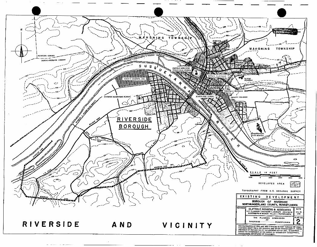
The development pattern indicates that the early development was influenced by the River Bridge, Pennsylvania Route 54, and the Sunbury Road. Development has spread outward from the area at the end of the River Bridge generally along the Sunbury Road. The newer developments are now occupying the vacant areas and are spreading toward the south and west.
To compile the data for this study, the Planning Staff conducted field surveys of the entire Borough. Aerial photographs 0 U . S . Geological Surveys, Sanborn Atlas and Tax Maps were also used to complete the study.
A s shown on the Plate entitled "Existing Land Use" , a pattern illustrating how the residents of the Borough are making use of the land for residential, commercial, industrial or public and semi-public uses in 1960, is presented.
A tabulation of the various land use in acres and a percent of the total land within the Borough is shown on Table 9.
It is readily seen from the Existing Land U s e Plate that the major portion of the developed area is in residential use, with industry generally located between the railroad and the River.
Commercial uses are rather conspicuous by their absence. The Borough is most fortunate that the few commercial uses which do exist, do not constitute a problem of major concern. In many communities the inter-mixing of commercial and residential uses present a major problem and have had adverse effects upon the value of the adjoining residential real estate. Through the adoption and enforcement of modern zoning regulations, the mixing of incompatible land uses can be checked in the future so that the Borough will retain its residential values.
-22-

Developed Land
The Borough of Riverside comprises a land area of approximately 3 , 436 acres. Due to the fact that presently only about 16.6% of the land area within the Borough is developed, it becomes necessary to differentiate between "built up" area and "total" area. The built up area is shown on the Plate entitled "Existing Development" and consists of the actual area now intensely developed for residential use. The remainder of the Borough is predominantly open land, used for farming purposes or woodland.
Residential U s e s
The major use in the built-up area is residential, which utilizes 127.5 acres or 22.4% of the land. The predominant residential type of structure is single fa.mily detached housing.
For the most part, the homes are well maintained and are built upon lots which provide adequate side, front and rear yards.
There are a few cases where homes exist on lots which have been further divided, thereby resulting in lots which do not provide an adequate side yard , rear yard or front yard. With the many vacant parcels of land existing in the developed area it will be necessary to provide zoning protection which will assure that yard areas will be provided as these vacant lots become developed,
Some of the older areas of the Borough are beginning to show symptoms of deterioration -- lack of paint, unrepaired porches and eaves, sagging sills and loose brickwork. These conditions, i f permitted to continue and spread, may cause serious damage to the adjoining properties, to the neighborhood area and eventually affect the entire Borough through the decline of property value, which in turn reduces the tax income to the municipality.
Through the adoption of land subdivision regulations , adequate lot area with front and rear yards will be assured. With zoning regulations the u s e will be controlled, assuring that the neighborhood will be composed of compatible uses which will assure the continued value of the investment in the real estate. With a stable level of real estate value, a high level of assessment can be maintained, which in turn provides a stable tax base to pro- vide for the required municipal services.
I
I
I
I
I I
! I
! I
I I
-23-

i. I I I I I I
‘0 1 I
With the adoption and enlorcement of a building code and a plumbing and electrical code, minimum standards of construction will be assured, whereby the original structure will be adequately built, minimizing the possibility of early deterioration due to faulty construction.
Commercial U s e s
Commercial uses within the built-up area occupy only 6 acres or 1 .O% of the land.
The existing commercial uses consist mainly of the neighborhood grocery store, a green house, building supply store, and radio-TV repair shop. At the intersection of Mil l Street and Pennsylvania Route 54, highway commercial uses have developed. Gas stations, a diner, an ice cream stand and a laundromat comprise the commercial activities at this intersection.
.
The other major commercial activity is the amusement enterprise at “D” Avenue and Third Street.
The lack of commercial development may be attributed to the nearby shopping center in the Borough of Danville. I t is possible, that when growth has reached a point where sufficient population is residing in the Borobgh, some form of shopping area may be economically feasible. at the present t ime the shopping facilities in Danville are adequate and convenient for the people of Riverside.
However,
Industrial U s e s
Industrial uses occupy 99.4 acres or 17.5% of the developed area.
Most of the industrial uses have located in the area between the railroad and the River. The largest of the industries is the Merck Co . , Inc .
Other industrial uses include a feed mill, coal yard, cabinet factory, a foundry and a dress manufacturing plant.
In general, the railroad has served as a barrier so that the most logical area for industrial development has been the area north of the railroad to the river. Al l of the industrial uses are now confined to the developed area.
-2 4-

Railroad U s e s
The availability of rail facilities in any community is generally a most desirable adjunct to the development of industrial or heavy commercial uses. Today's industry not only requires good highway facilities, but in most instances also requires rail siding. Riverside has been rather fortunate in that the railroad has been located so that industrial and/or commercial uses may be located on the land between the river and the railroad.
The Sunbury-Wilkes -Barre Branch of the Pennsylvania Railroad runs east and west, the entire length of the Borough. Within the built-up area, the railroad utilizes 11.4 acres or 2.0% of the developed land.
Street Rights -of -Way
The rights-of-way for streets and alleys within the Borough occupy 94.4 acres or 16.6% of the developed area. With the average community having from 20 to 25 percent of the land area utilized by street rights-of-way, the 16.6% in Riverside indicates that the Borough does not have an excessive amount of land in this category.
As a percent of the total land area of the Borough, only 3.7% or 127.6 acres are utilized by roads and streets. T h i s figure is reasonable when the large areas of farm and woodland are considered.
'
Public and Semi-public U s e s
Included. in this category are churches, schools, cemeteries, fire houses and any land or buildings owned by the Borough.
Two uses account for the majority of public land; the new Riverside Elementary School, located west of "A" Avenue, and the Kase Cemetery, at the south end of "G" Avenue. The remaining public land is used by churches, the two old elementary school buildings, the post office and the borough building.
Farm or Vacant Land
Within the developed area, many quarter blocks, lots and open vacant land exist. Vacant land comprises some 2 18.7 acres or. 38.3% of the built-up area still remaining. The largest area of vacant land still within the built-up area is the area between Borough Line Road and the airport south of Sunbury Road. While this area is now considered vacant, subdivision plans
-25-


have been prepared to develop this area with residential uses . Farm or vacent
acres or 75.2%. Of this 2585.2 acres, some 837.7 acres are now in woodland. @ land, when considered in relation to the total land area, accounts for 2585.2
River Bed
Included in the total land area of the Borough is 355.5 acres or 10.4% of river bed . The river bed is included because the borough line extends to the center of the River.
TABLE 9
EXISTING LAND USE
Residential
Commercial
@ Industrial
Railroad
Public & Semi -Public
Deve-loped Remainder Percent Percent Area of Borough of Developed of Total
In Acres In Acres Total Area Land Area
127 .S 13.7 141.2 22.4 4.1
6 .O -- 6 .O 1 .o .2
99.4 -- 99.4' 17.5 2.9
11.4 19.8 31.2 2 .o .9
12 .S 77.5 90.0 2.2 2.6
Street & Highway Rights - o f -Way
Farm or Vacant
River Bed
Total
94.4 33.2 127.6 16.6 3.7
218.7 2366.5 2585.2 38.3 75.2
-- 355.5 355.5 -- 10.4
569.9 2866.2 3436.1 100 .o 100 .o
Source : Consultant
-26-

Conclusion
A s shown on the Plate entitled "Existing Land Use" , it can be seen that the majority of Riverside's past and present development has taken place near the Susquehanna River, generally west of the River Bridge to Danville . Single family detached homes are predominant, although there are some two family dwellings found in the area which was originally developed north of Sunbury Road. New residential areas have developed south of Sunbury Road to Legislative Route 49040 to the south and west to Borough Line Road. Additional new development has occurred directly adjacent to the major high- way facilities, specifically, Pa. R t . 54, and Sunbury Road to the west of the Danville Airfield.
With the conspicuous Sack of commercial enterprises and with the confinement of industrial uses north of the Pennsylvania Railroad to the River, there has been very little conflict i n mixed land uses. There are a few neighborhood commercial stores located within the residential areas which should be discouraged in the future. With the aid of the Zoning Ordinance and proper planning, these mixed land uses will not be permitted to develop in the future.
The major concentration of commercial uses has occurred near the intersection of Pa. Route 54 and Sunbury Road. If these uses are limited to this area in the future, the residential property values adjoining this area should remain stable. However, i f commercial and industrial uses are allowed to become intermixed and scattered throughout the Borough, then the result will be a detriment to the adjoining residential areas. .
Outside of this developed area, the predominant land use is in agriculture and forest land. With 75.2% of the land within the Borough, farm or vacant, there is adequate land available €or luture residential development as well as land for industrial park purposes. Much of this undeveloped farm and wood land is too steep for adequate building facilities so this land could be developed in the future as a park area for picnicking, hiking and other recreation activities,
It becomes very important that this open or undeveloped land be planned adequately for future uses so that borough utilities can be extended into these areas. With the additional help of the Zoning Ordinance and Land Subdivision Regulations, the Borough of Riverside will remain a growing and prosperous municipality.
-27-

I
'0 I I I I I I I I. I I I I
The area west of the Danville Airfield and north of Sunbury Road, is sparsely settled with single family dwellings and farm groupings. With adequate highways and the present rail facilities to the north of Sunbury Road, this area could, in the future, become an excellent industrial park location.
Single family dwellings have also been constructed along Pa . R t . 49043 and other local roads in the area. In general, these scattered dwellings have been well constructed and maintained and are a betterment to the Borough.
On the whole, the new development within the Borough has been satisfactory. -With the exception of a few properties within the older section of town, the lots have adequate side, front and rear yards. A few homes have been developed upon land which has excessive slope, thus causing unsafe conditions to exist, but for the most part past development has been orderly.
It is unfortunate that in the past the street systems did not conform. Consequently, today we have many bad intersections and dead end streets, resulting in small or odd shaped residential lots. If these streets had been laid out in accordance with an accepted over-all plan, this situation would not exist today. Today, having adopted the Land Sub- division Regulations, the Borough will now control and review all streets and lots thereby preventing in the future the recurrence of such conditions.
Keeping the Land U s e Map Current
To be of continuing value to the Borough Planning Commission, the Land U s e Map should be kept up to date. This updating process can readily be accomplished through the review of zoning permits on an annual or semi-annual basis.
-28-

EXISTING COMMUNITY FACILITIES
SCHOOLS
The educational system for the Borough of Riverside is a part of the Danville Area Joint School System, which serves the entire County of Montour and the Borough of Riverside. There are presently ten elementary buildings 8 a junior high and a senior high school in this jointure. For the purpose of this report, we will mainly be concerned with the school facilities as they pertain to Riverside.
For a Borough to improve its community facilities, they must provide and maintain adequate, up-to-date schools and playgrounds . Require- ments must be met for both the present and future population of Riverside.
ELEMENTARY SCHOOLS
Riverside Elementary Building
The present elementary school building in Riverside is located 0 north of Sunbury Road to the west of "A" Avenue. This modern school facility was built in 1957 and replaced the original school which was built prior to nineteen hundred and was located on "Z" Avenue at Fourth Street.
T h i s new Riverside Elementary School, located on a seven acre site, provides six classrooms, plus facilities for auditorium use, a cafeteria and kitchen, and a stage. Although this facility has an existing capacity of nearly two hundred pupils, the Gearhart Building, in 1961, had to temporarily accommodate first grade students. This indicates that in the near future, new facilities will have to be added to the Riverside Elementary School. In addition, planning for future school sites must be started now so that land acquisition can be started before land values are raised in the newly developing areas.
Plans are now being prepared for the addition of three classrooms and a library to the present school. This will alleviate the problem of sending students to the Gearhart Building which is located at Dewart and Montour Streets With the new classrooms being added to the present school, it becomes advisable to secure additional land adjoining the site to insure ample land for recreation and future expansion of school and neighborhood needs.
-29-

-- The Gearhart Building
The Gearhart School Building, which was originally built in 1871 by the Gearhart School District, was located in the area which was then called South Danville . This structure, a one-story brick facility, was enlarged in 1900 to accommodate additional pupils. The school is still being used by the Borough as a kindergarten and as an overflow to the new element- ary school. The site, comprising over an acre of land, affords the pupils and residents of the area a recreational playfield, plus two classrooms.
Also in 187 1, a two-story brick structure was erected in the original Riverside area, which was under School District supervision by 1873. This school building, which has recently been sold, was named the Riverside School Building and was located on a site approximately one-third of a n acre which under present day standards is considered inadequate.
With Pdverside continuing to expand as it has done in the past, it will become necessary to build additional schools to accommodate the newly developing areas to the south of Sunbury Road.
JUNIOR HIGH SCHOOL
The existing Junior High School is located outside of Riverside in the Borough of Danville on East Front Street. Its present enrollment is about 650 pupils, which is 100 more than the structure was built to accommodate. The size of the site is inadequate to provide the proper recreational area for the needs of those served. Presently, the Danville Area Joint School System is anticipating the addition of new classrooms and facilities which will add to the efficiency of the school system.
SENIOR HIGH SCHOOL
The new Danville Area Senior High School, which is located on Northumberland Street, contains an area of 19 acres and was formally dedicated in 1959. Th i s modern school facility contains 20 classrooms, in addition to rooms for home economics, vocational training, agriculture, metal shops , music, art and business education, plus an auditorium, gymnasium, cafeteria, library, staff rooms and office space for the County Superintendent of Schools. The Borough of Riverside , being a part of the School Jointure, is very fortunate to be able to use the facilities of the Senior High School.
-3 0-

. . . ._
PUPILS
S C H O O L E N R O L L M E N T T R E N D . S B O R O U G H OF R I V E R S I D E
PLATE
6

ENROLLMENT TRENDS
Based upon past school enrollment trends, as graphically shown on the Plate entitled "School Enrollment Trends", it can be expected that the elementary school enrollment should continue to increase. This increase will be determined somewhat by the percent of immigration and outmigration that can be expected to occur each year, and also by the number of school age children who will attend the parochial school located in Danville.
The estimated future elementary and secondary enrollments for Riverside have been projected for the ne,* six years and are shown graphically on fie Plate entitled "School Enrollment Trends". These estimates have been made on the basis of the school enumeration figures for the Borough, i.e. the number of pre-school age children who are presently under six years of age who will start to school between the years of 1961 and 1966. These enumeration figures show only the number of children who are living within the Borough now and do not reflect those children who will be moving into the area. The yearly estimates will also be affected by the general social and economic condition of the Borough and the ability of the community to attract new residents. A s stated before, a percentage of these pre-school age children can be expected to attend parochial schools thus reducing the number of children in the public schools.
The following Table , entitled School Enrollment, shows the elementary and secondary enrollments for the past eight years of the pupils from Riverside. The total enrollment has been steadily rising and has increased by 46% since 1953.
TABLE 10
SCHOOL ENROLLMENT BOROUGH OF RIVERSIDE
Elementary Secondary
1953-54 163 1954-55 2 05 1955-56 2 08 1956-57 18 1 1957-58 159 1958-59 156 1959-60 172 1960-61 165
@ Source: Danville Area Joint School System
55 43 52 83 101 136 137 154
Total - 2 18 2 48 260 2 64 260 292 3 09 3 19
-3 1-

PARKS AND PLAYGROUNDS
An important public facility which must be afforded the residents of any community is a park and recreation program. Today, with the population enjoying more leisure t ime due to the decrease in working hours, people need additional forms of active and passive recreation. Also 8 with the automobile playing such an important part of everyday living, people desire to travel away from the urban centers to parks and rural areas where they can relax in a more informal atmosphere.
At the present time, the Borough of Riverside has only two organized play facilities 8 both located at the existing school sites. Although these areas are utilized by the school children and the adjacent residential properties, the available land area is inadequate to meet the demands of the entire Borough. Al so , because of their geographic locations 8 these two areas are separated from the neighborhood to the south of Sunbury Road which makes them unsafe for young children crossing the heavily travelled highway. Consequently, it is recommended that the Borough acquire additional land for recreational purposes in other sections of the area. It is also recommended that sufficiently large sites be acquired for future elementary schools so that recreational facilities can be provided in co,njunction with the school. This eliminates many administrative and maintenance problems since the two facilities would be under the direct supervision of the School Board.
A large park with facilities for picnicking, hiking, sports fields and other recreational facilities, along with areas of natural woodland and meadows , should be incorporated into the planning for future residential needs With the abundance of woodland area within the Borough l i m i t s , it is advised that adequate land be secured for a large park area which would serve the entire region.
With many sections of the Borough becoming built up with residential homes and with the scattered individual open spaces being developed, it is important for the Borough to reserve land for school and recreation facilities so that adequate areas 8 properly located with respect to homes and major streets, will be secured for future use.
SWIMMING POOL
The Kipp's Run Swim Club'is located east of the "built up'' area south of Sunbury Road and Kipp's Run, along Legislative Route 49043 Club provides private swimming facilities €or residents of Riverside and
This
i i i 1 i 1 ! i I j
vicinity. e -32-

0
e
l
I
I I
'0 I
OTHER COMMUNITY FACILITIES
Post Office
The existing Riverside Post Office is located at the northeast corner of "F" Avenue and Fifth Street. The structure was originally built in 1905 to provide a meeting place for the Patriotic Order Sons of America. The post office shares the first floor with a commercial establishment. Borough residents are realizing the need to build a new post office facility with modern conveniences. In selecting a site for the new Post Office , consideration should be given to the overall plan for the community.
Churches
There are two churches located within Riverside. These are the St. Peter's Methodist Church at Logan and Gearhart Streets and the Assembly of God Church located along Sixth Street between Avenues "E" and "F". Other denominational churches are located across the river in Danville . Hospital
The Geisinger Medical Center, which is located in Danville , provides 309 beds and an excellent staff of doctors. It is indeed fortunate that the residents of Riverside have access to such a modem hospital facility.
Library
Although there are no public libraries located in Riverside, the Danville Public Library provides an excellent assortment of books and other reading material. The Library is located adjacent to the Central Business District in Danville . Fire Protection
The Southside Fire Company No. 1 is located on the corner of Fifth and Line Streets. The equipment is as follows:
1960 - Chevrolet 500 g .p .m. Pumper with 500 gal. booster tank 1951 - GMC 1200 gal. tank truck 1942 - Chevrolet 500 g.,p.m. pumper with 350 gal. booster tank
The Southside Fire Company now has 165 active members. The Fire Company building is also used by the Borough Council for its regular meetings.
-33-

Police Protection
The Riverside police force consists of two part-time patrolmen. As the community continues to grow and expand, it is recommended that a well- equipped full-time police force be set up to cope with the many police duties which occur throughout the community. A facility of this type could be incorporated with the fire station and other borough facilities.
Airfield
The Riverside-Danville area is now served by the Danville Airport, located south of Sunbuy Road and west of Blue Hil l Drive. The present airport is owned jointly by Montour and Northumberland Counties and is operated by a private individual.on a lease arrangement.
The present development consists of a hangar and office building with no paved runways or lighting. Mer& and Co. 8 Inc. I along with many of the industries i n Danville, and Geisinger Medical Center, are major users of the charter service provided by this air€ield . Due to its development, the airfield is definitely handicapped, for only relatively light aircraft can now land or take off from the grass runways. If improved facilities were made available, the field would undoubtedly be of greater benefit to the present users and would also be an additional factor in attracting industry.
In 1958, the Federal Aviation Act empowered the Federal Aviation Agency to encourage and promote the development of civil aeronautics and air commerce in the United States and abroad. A s a part of this program, Federal grants in the amount of 50% to aid in the cost of developing an adequate program were made available. The aid is available to states, counties #
municipalities, or other municipal subdivisions or agencies, so that the present airfield 8 being owned by two counties 8 would be eligible. However, before such aid can be secured, a survey by the Federal Aviation Agency as to the physical limitations of the present facility must be conducted . This survey covers such items as topography, high tension lines, water courses 8 and any other man-made or natural hazards to flight. TOO, the availability of land for the e::tension of present or future runways is a factor. The proximity of residential or school uses which would be placed in jeopardy by aircraft are all considered along with many more technical i t ems before Federal Aid is granted .
The Federal Aviation Agency has just completed a survey of this airfield to determine i f Federal funds would be made available. The results of the survey indicate that it is not desirable to expend funds to the airport in its present location .
-34-
L E G E N D
umm.m.m EXISTING SEWER LINE--I.
-mmm EXISTING MANHOLE

MUNICIPAL FINANCES
Income
A s is the case in the majority of boroughs, the chief source of income for the Borough of Riverside has been the taxes levied upon real estate. T h i s has remained relatively stable over the period horn 1955 to 1960. While the income for sewers constitutes a large percentage of the income, this money is actually in payment for the use of the sewer facility and must be used to repay the sewer authority bonds as shown on the Plate entitled "Income and Expenditures". The sources of income expressed as a percent of the total revenue are shown on the following table:
TABLE 11
Occupation Tax Licenses & Permits Fines & Forfeits State & Federal Grants State Highway Aid County Grants Sewer Rental &
Installation Street Openings &
Repairs
SOURCE OF INCOME 1955 - 1960
,1955
37 .O 1.1 .3
2.5 2.9 7.8
48.4 --
--
1956
31.9 1.2 .2 .9
14.2 9.4 42.2
-
--
--
1957
30.4 1.1
. 3
.8 2.3 13.1 7.7 44.3
-
-- 100 .o 100.0
Source: Pa . Department of Internal Affairs Borough Reports
100.0
1958 1959 -- 32.9 31.9 1.2 1.2
. 2 .2
.6 .2
13.7 12.7 6.6 7.4 44.9 45.9
_- -_
100.0 100.0
1960
31.5 1 .o .1 .4
12.1 8.2 46.7
--
-- 100.0
The assessed valuation, millage and receipts for the years 1955 through 1961 are shown on the following Table.
-36-

TABLE 12
ASSESSED VALUATION - MILLAGE & RECEIPTS . 1955-1961
year Assessed Value Revenue Receipts
1955 1956 1957 19 58 1959 1960 196 1
1,038,940 1,050,000 1,072,000 1,213,000
1,303,525 1,273,000
2, 309 8 225
Source: Pa. Department of Internal Affairs Borough Reports
32 , 026
40,045 38,439
42,637
37 # 341
40,854
_-
Millane
12 .o 12 .o 12 .o 11.0 11.0 11 .o 6 .O
Many citizens have long used the assessed value or millage, particularly the latter, as a measure of the tax load. However, due to the fact that assessed value can range from less than 20% of the market value to more than 100% of the market value, clearly indicates that this method does not provide an accurate basis for determining tax load.
In order to provide a more accurate measure of the load, the Bureau of Municipal Affairs prepared an adjusted millage rate in their 1959 report. The adjusted millage for the Boroughs in Northumberland Sunty ranged from 1.67 mills to 5.67 mills with Riverside at 2.20 mills, next to the lowest in the County.
On a non-adjusted millage assessment basis, the millages for the Boroughs in the County ranged from a low of 10 .O to a high of 32 5 with the average being 19.6, Riverside millage was 11 . O , Likewise, the assessment ratio to market value ranged from a low of 13.1 to a high of 22.7 with an average of 17.9. Riverside's assessment ratio was 20.0.
In an effort to equalize this wide variation of assessment and millage, the entire County of Northumberland was re-appraised and assessed. The new assessment was used for the basis of the 1961 tax levy and is computed at 25% of the market value of the real estate.
As a result of the reassessment program, the Borough's assessed value increased from $1,303,525 to $2,309,225.
-37 -

Indebtedness
By law, the Borough can now borrow up to 2% of its assessed valuation and a n additional 5% of the as-sessed valuation when approved by the voters.
On the basis of the increased assessed valuation for 1961, the borrowing capacity has been increased as shown below:
1961 - 2% Councilmanic 46,000. 5% Elector 115,400.
161,400.
Act 398
- 1960 Increase
26,000. 20,000 65,000. 50,400
91,000. 70,400.
The Governor, in 1961, signed -.?to law a n amendment to the Municipal Borrowing Law which permits local governments to borrow up to seven percent of the market value rather than seven percent of the assessed value as previously permitted. This amendment to the 1941 statute does not change the 2% councilmanic l i m i t or the 5% elector approved l i m i t which is set by the Pennsylvania Constitution; only the basis for computing the seven percent limit has been affected.
While this has been signed into law, there are serious questions as to the constitutionality of the A c t . Until such t i m e as the A c t is upheld in the courts, it would appear advisable to continue to use assessed valuation as a basis for borrowing capacity. Should the A c t be declared constitutional, it will be of great benefit to communities who are moderately well off.
The Ac t would permit such a community to choose between obligation bond financing and authority financing. This would permit the community to retain more direct control over the operation when such operations are carried out by a n appointed authority board. This does not mean that authority financing will no longer be useful, only that the Act will permit a wider range of choice as to the type of financing that a com- munity may use.
If this Ac t would be held constitutional, the borrowing capacity, based upon market value of $9,236,900, would be as follows:
-38-

1 I j
I .. .
2% Councilmanic 5% Elector
Based on Market Value Assessed Value Increase
184,700. 46.000. 138,700. 461,800. 115,400. 346,400.
646 , 500. 161,400. 485,100,
At the present t ime, the Borough is entirely free of bonded debt. Based upon the assessed value of 1961, the borrowing capacity would be as follows:
Debt Limit 7
2% Councilmantc 46,000. 5% Elector approved 115,400.
Present R e rnaining Debt Borrowing Capacity
0 46,000. - 0 115,400.
161,400. 0 161,400.
A debt free community is in a most enviable position, especially when the trend toward deficit financing is the current vogue. However, many municipalities in the past have been "penny-wise and pound-foolish" by not making an expenditure for a necessary public facility or acquisition of a play area when such land or facility would have been relatively inexpensive
Riverside Borough has recognized in the past the necessity to provide services such as the present sewer system. In the coming years, additional communi ty facilities and services will be required.
If the improvements to a community are to be realized, then investments must be made, just as in other types of business. The return on the investments in improvement to everyday living amenities is mast difficult to measure in dollars and cents: however, a progressive Community can exert a stimulating influence into all phases of a community.
Additional Sources of Revenue
In order to meet the rising costs for the increasing number of services which a municipality must provide, additional sources of revenue must be explored. The Legislature in 1947 passed P .L. 1145, known as the Local Tax Enabling Act, or Act 481, as additional source of revenue for practically all forms of local government in the Commonwealth. This statute gives the Borough (and other forms of local government) authority to tax persons,
-39-

I N C
B S T A T E '/a
H I G H W A Y A I D 1 2 . 1
R E A L ESTATE TAX 31.5
OCCUPATION TAX 1.0
L I C E N S E S a P E R M I T S 0 . I
0.4 F I N E S 8 F O R F E I T S
G R A N T S a G I F T S 8.2
S E W E R S 4 6.7
I I l i a s s l l M . # w m m I I m O M E A N D E X P E N D I T U R E
O R O U G H O F R I V E R S I D E 1 9 6 0
I N C O M E € X P E N D I T U R E /a
'0- s
S G E N E R A L GOVERNMENT
10.4
0.9
I N G U M
4 2 , 6 3
2 8 . 8
0.8
5 4 . 9
PROTECTION TI PERSONS 8 PROPERTY
H E A L T H & SA NITAT I ON
HIGHWAYS
M I S C E L L A N E B
S E W E R S
P L A T E

transactions, occupations, privileges and subjects within the limits of the subdivision levying the tax. This broad grant of power is subject to various limitations i n that certain exemptions are provided and l i m i t s are set on the rate of certain taxes levied under the Act , along with limits on the amount of revenue that may be raised.
The types of tax generally levied under this Act are as follows:
Income Tax, Per Capita Tax, Mercantile Tax, Deed Transfer Tax, Amusement Tax and Tax on Mechanical Devices
In a recent study made by the Department of Internal Affairs, the following types of taxes were collected during 1958 under Act 481 in order of their yield :
% of Total 481 Levies Collected
1. Earned Income 2. Per Capita 3 . Real Property Transfer Tax 4. Mercantile Tax 5 . Amusement Tax 6 . Occupation, mechanical device & trailer
53% 24% 12 % 6%
3.5% 15%
The Borough has enacted an earned income or wage tax; however, Mi& increased activity i n real estate transfers, the possibility of utilization of this source could be explored by the Borough.
Expenditures
Expenditures i n general appear to be reasonable The increase in sewers and sewer treatment in 1958-59-60 is due to a change in tabulation by the Commonwealth, and the increase is due to the inclusion of principal paid on indebtedness from 1958 on.
A tabulation of the operation and maintenance expenditures, expressed as a percent of the total, has been prepared for the period 1955 to 1960 and is shown on the following Table.
-40-

7
TABLE 13
OPERATION AND MAINTENANCE EXPENXTURES
(Not including capital outlay) -1955 - 1960
General Government Police Fire Planning & Zoning Sewers & Treatment Refuse Disposal Streets & Highways. Street Lighting Miscellaneous
1955 - 11.4 9 -2 2.4
14.1 .4
34 .O 12.6 15.9
--
1956.
13.2 10.1 6.8
12.7
43.4 13.8
-_ A a *
-_ Source: Pa. Department of Internal Affairs
Borough Reports
1957
12 .5 6.6 1.2
7.9 e4
62.8 8 .6
-
--
--
1958
6.6 3.9 .9
50 .2 .8
31.3 6.3
--
--
1959
7.3 3.8 1.0
61.2
16.8 8.1 1.8
-- --
1960
7.2 4.6 1.2 4.6
54.9 .9
17.7 8.1
.8
-
Expenditures under this heading include those major expense i t ems 8 such as major new equipment, the construction or extension of facilities , or extensive improvements. Not included would be normal operating and main- tenance expenses.
As may be noted on the following Table, the major expenditures have been for streets and sewer facilities . In the future, with the adoption of land subdivision regulations, much of the outlay required for streets will not be required, in that the developers will be responsible for the streets.
-41-

TABLE 14
CAPITAL OUTLAY 1955 - 1960
1960 . 1959 - Public Safety 2500. 2500. Streets & Highways -- 6674. Health & Sanitation 2084. 522. Parks & Recreation _ _ -- _- -- Municipal Utilities - -
Total 4584. 9726.
1958 - 217. 1329. 408. -- -- - 1954.
1957 1956 - 678. 703. 2325. 9508. 2959. 1484.
5962. 11695.
1955 - 330. 6126. 1729. -- -- - 8185.
Source: Pa. Department of Internal Affairs Borough Reports
-42 -

MAJOR THOROUGHFARE PLAN
C las si fication of Thorouq hfares
In the study of existing and proposed circulation which affects the Riverside area, it becomes necessary to classify the streets and highways into designated types on the basis of the function each is to perform. Although traffic volumes,to a large degree, determine the location and classification of each road system, other factors such as land uses and topographic features also play an important part.
As shown on the Plate entitled "Recommended Road Cross Sections", the classification of streets and highways has been made. In general, five types of road classifications have been made and are as follows:
Interstate Hishways -
Major existing or proposed Federal Highways which pass through the State or area. An example would be the Keystone Shortway, which is limited access and designed to carry high speed traffic i n large volumes.
Primary Roads
Other major Federal, State or local roads which take traffic to or through an area. These roads carry large traffic volumes and are designed for fast and heavy traffic.
Secondary Roads
They provide the principal means of circulation between population centers in the area and do not normally carry the larger volumes of traffic, These highways would serve as feeders to the primary system.
-43 -

P
Collector Streets
I
They carry traffic from the local streets to the system of primary and secondary roads. Collector roads would include the main entrance or circulation streets serving a neighborhood.
Minor Streets
These are local or residential streets which provide access to the abutting properties.
The Resional Picture
The Borough of Danville is located at the intersection of U . S. Route 11 and Pa . Route 54. The U S . Route connects Harrisburg and points south with the Scranton-Wilkes-Barre area and points north in New York State . It also serves as a vital link between the series of urban areas including Sunbury, Northumberland, Berwick, Bloomsburg as well as Danville and the immediate area. Route 54, a north-south State highway, passes through Danville as it comes south from the Williamsport district and then crosses the River Bridge into Riverside. From Riverside, Route 54 continues south to the Mt. Carmel area.
Included within this study of regional aspects which concern Riverside are the two proposed major expressways which will affect the entire area, as well as the County and State. The first of these major Federal highways is the Keystone Shortway, which will constitute a direct line between the Ohio Turnpike and the New York City area, In its east-west course through Pennsylvania, the Shortway will pass a few miles to the north of the Danville-Riverside area.
The second link in the Federal Interstate System which will affect Riv2rside, is the proposed Anthracite Expressway , which will provide a more direct route between Scranton and Harrisburg.
These two major expressways should result in increased economic activity throughout the area. This should help influence new industry and commerce, along with new residential growth to accommodate the new enter- prises. Along with this anticipated upturn in economic activity will also come a more intensified local circulation problem which will be further com- plicated by the normal population growth and the increased automobile owner- ship trends.
‘ 0 -44-
The Local Picture
I '
I I I
'e i k
The traffic routes which carny the heaviest volume of traffic through Riverside are Legislative Route 49 043 (Sunbury Road) and Legislative Route 49040. Sunbury Road, which passes through the Borough from east to west, carries a traffic volume of 1150 vehicles per day, according to the adjusted 1959 State traffic counts. Legislative Route 49040, which enters the Borough from the south, carries 700 vehicles per day. The River Bridge and Route 54 carry a much heavier volume of traffic, but fortunately they do not pass directly through the major portion of the Borough. The River Bridge carries 4100 vehicles per day, while Route 54 carries 2650.
These volumes may be seen visually on the Plate entitled "Traffic Volume Flow". There is a major portion of west-bound traffic on Sunbury Road between the River Bridge and "G" Avenue which is quickly dispersed throughout the Borough.
The following Table gives the standards for highways as developed by the Pennsylvania Department of Highways. These standards are applicable to all highways i n the State, except those highways on the Federal Interstate System.
TABLE 15 STANDARDS FOR TRAFFIC LANES
Traffic Volume (24 hour average) No. of Lanes Width of Lanes
under 800 2 9 feet 800 to 1500 2 ' 10 feet 1500 to 3500 2 11 feet 3500 to 5000 2 12 feet 5000to 13000 4 11 feet 13000 to 20000 4 12 feet
Source : Pennsylvania Department of Highways
"G" Avenue, which was originally laid out as a minor residential street, is now doing the job intended for a collector street. The road width and right-of-way is presently insufficient to carry the load that is using it In the future, the traf€ic using Legislative Route 49040 should be rerouted to a new thoroughfare which will be designed by larger standards. "G" Avenue will then become a minor residential street which will make it a more desirable street on which to live.
-45-

Also, as may be seen on the "Traffic Volume Flow" Plate, the most intense traffic is located at the approach to the River Bridge, thus reducing the efficiency of traffic flow.
It is of even more importance to analyze these major thorough- fares with future needs in mind. As the Borough grows in s ize and economic importance, the circulation facilities must also grow and improve. Within the near future, the area bounded by Sunbury Road and Legislative Route 49043 will be developed for residential purposes. It is important that this new development be planned to conform with the existing circulation plan of the Borough. This will insure that improper intersections and street alignment will be provided.
With suitable open land north of Sunbury Road available for future industrial park development, a new access road into the area should be contemplated. The Sunbury and Wilkes-Bane Branch of the Pennsylvania Railroad crosses through the area from east to west, thus providing rail facilities for new or expanded industrial uses.
As shown on the Plate entitled "Major Thoroughfares", a n east- west highway and a north-south highway are proposed.
The east-west highway would be the extension of the present Third Street east to Kipp's Run, where it would rejoin the Sunbury Road (Legislative Route 49 105). This new highway would accomplish two major objectives; ode, the removal of heavy thru-traffic now using the Sunbury Road, and two, provide access to the highly desirable industrial land north of the proposed road. It would be most desirable to remove the present thh- traffic from Sunbury Road,for the entire distance from "A" Avenue west to Mill Street has developed as a residential area, with the open land west from "A" Avenue rapidly developing as a residential section.
The development of the east-west or industrial highway could be accomplished ia two stages as the development advances. The first stage could be the extension east of Third Street to the proposed north-south highway. With the construction of that portion of the north-south highway north from Sunbury Road to the industrial highway, a logical extension and continuation of roads could be accomplished. The second stage would then be the continuation east and south of the two highways.
-46-


The North-South Highway would provide a more direct connection with the "industrial highway" and would also remove the thru-traffic from the residential areas on either side of "G" Avenue. The proposed north-south highway would also provide more direct traffic circulation through the center of the Borough. Too, the new roadway would have adequate rights of way and proper alignment to eliminate sharp curves and blind intersections. With the planning of these two highway facilities, the improvement of the intersection at Mill Street and Route 54 should also be advanced with the Highway Department. Increased traffic on Route 54, due to its connection to the Shortway, along with increasing traffic volume due to new residential develop- ment and increased industrial employment, indicate a need for improvement at this intersection.
Accomplishins the Major Thoroughfare Plan
While the accomplishment of the proposed highway system in its entirety must be accepted as a long range undertaking, it is possible with an increased demand €or desirable land for development, the first stage of the plan could occur in the near future.
The right of way can be acquired as the land is developed through the review of the subdivision plans by the Planning Commission. The land subdivision regulations require that the necessary land for right-of-way be dedicated as one of the conditions of approval. This system provides the Borough with the easiest method and the least costly method of obtaining the necessary land for right of way for highways. This method, however, is dependent upon the land being opened for development by the owner. Should the acquisition of right of way not be accomplished through dedication, then negotiation and purchase would be required. The Borough does, however, have the power of condemnation to acquire land for highway purposes if purchase cannot be negotiated.
DESIGN STANDARDS
Streets
The arrangement, character, extent, width, grade and location of all streets shall conform to the General Community Plan and shall be considered in their relation to existing and planned streets, to topographic conditions, to public convenience and safety, and in their appropriate relation to the proposed uses of the land to be served by such streets and shall conform to the following Design Standards i n a manner acceptable to the Planning Commission.
-47-

1.
2 .
3 .
4.
2 .
5 .
6 .
7 .
8 .
Where not shown on the Goneral Community Plan, the arrangement of streets in a subdivision shall either:
a. .
b.
Provide for the continuation or projection of existing principal Streets in surrounding areas; or Conform to a neighborhood plan to meet a particular situation where topographic or other conditions make continuance or projection of existing streets impracticable.
Minor streets shall be so laid out that their use by thru-traffic will be discouraged.
Where a subdivision abuts or contains an existing or proposed primary street or a railroad right-of-way or rail crossings, access thereto shall be limited to a minimum number of intersections as practicable and such major access intersections with primary streets and/or rail crossings '
shall be determined with due regard for sight distance, distance between intersections , approach grades and requirements for future grade separations.
Margiflal access streets paralleling such limited access primary streets shall be required , in such cases where practicable , reversing the frontage of residential properties with a screen planttng contained in a non-access reservations strip along the rear of and between the property line and the primary street right-of-way; such strips shall be prohibited except where their control is definitely placed with the municipality.
Street jogs with centerline offsets of less than one hundred and twenty- five feet (125') shall be avoided.
A tangent at least one hundred feet (100') long shall be introduced between curves on primary and secondary and collector streets.
When connecting street lines deflect from each other more than ten (10) degrees, they shall be connected with a curve with a radius adequate to assure sight distance.
Streets shall be laid out to intersect as nearly as possible at right angles and no street shall intersect any other street at less than sixty (60) degrees.
61 m II 111 1 d
1 I n II
-48-

\

9 . Street right-of-way widths shall be not less than as follows:
Primary Streets Secondary & Collector Streets Minor Streets 60 feet Marginal Access Streets 50 feet Alleys 20 feet
80 to 120 feet 60 to 80 feet
10. Dead-end streets, designed to be so permanently, shall not be longer than six hundred feet (600') and shall be provided with a turn-around, an outside road diameter of at least eighty feet (80'), and a property line diameter of at least one hundred feet (100').
11. No street grade shall be less than two percent (2%) or more than ten percent (10%) unless. topographic conditions make a steeper grade necessary,
12. No street names shall be used that duplicate existing names or in any way can cause confusion in the provision of police and fire protection, refuse collection or the distribution of ma i l by the U . S. Postal Service.
13. Easements across lots, centered on rear or side lot lines, or where necessary for utilities, water course, drainage way, channel or stream shall be not less than fifteen feet (15') wide.
Blocks
1. The length, width and shape of blocks shall be determined with due regard to:
a.
b. c . d
Provision of adequate building sites for the special type of use contemplated . Requirements as to lot size and dimensions. Needs for convenient access, circulation, control and safety of street traffic. Limitations and opportunities of topography.
2 . Block lengths shall not exceed eighteen hundred feet (1800').
3 . In cases where the block length exceeds six hundred feet (600') and/or where deemed essential to provide pedestrian circulation to schools #
playgrounds , shopping centers and other community facilities 8 an ease- ment for a crosswalk shall be provided of not less than ten feet (10') wide.
-49-
t'
Curbs and Gutters
When requirec by the Governing Body, the subdivider shal insta 1 curbs and gutters as approved by the Governing Body and constructed as follows:
1. Straight Portland cement curb, 22" x 6'' 8 top rolled and battered to 8" at bottom, 6" face exposed above finished road surface.
2 . Integral Curb and Gutter, 24" x 6" :c 6" , battered and rolled Portland cement concrete
3 . 6" ID-2 Bituminous curb where approved by the Municipal Engineer and/or the Pennsylvania Department of Highways.
4 . Rolled curb and'gutter, 11" x 7" x 24", Portland cement concrete, poured mnolithically .
5 . Lip Gutter, 6" x 9" x 30" 8 Portland cement concrete8 reinforced and poured monolithically .
Sidewalks
When required by the Governing Body, the subdivider shall install sidewalks constructed as follows:
1. 4'' Portland cement concrete.
Street Name Sians
The subdivision shall be provided with street name signs at all intersections . Such signs shall conform to Borough standards and shall be approved by the Governing Body.
Street Trees
The subdivider shall seed the planting strip between the curb and sidewalk , i f either or both are required and/in addition , provide street trees of a caliper not less than 1-1/2" and planted 40 to 60 feet apart. The type and spacing of the trees shall be approved by the Planning Commission and the Governing Body.
Following is a list of acceptable trees:
-5 0-

164' TO 200' R / W
I N T E R S T A T E EXPRESSWAY
c 24'
PRIMARY ROAD 1'. STAGE 80' TO 120' R/W
PRIMARY ROAD 2u- STAGE
60' TO 80' R/W
SECONDARY ROAD
38' I MIN. 60' R/W
ci
C O L L E C T O R ROAD
Paving
MINOR OR LOCAL STREET P L A T E
I I MENDED WQAQ CRQSS SECTIONS
THE PREPARATION OF THIS HAP WAS FINANCED I N PART THROUGH AN URBAN PLANNING GRANT FROM THE HOUSING AND HOME FINANCE AGENCY, UNDER P R O V I S I O N S OF SECTION 701 OF THE HOUSIN ACT OF IS%, CLIFTON E. RODGERS Ef ASSOCIATES
BEAVER F A L L S Ef HARRISBURG, PENNA. DEVELOPMENT, PENNSYLVANIA DEPARTMENT OF COMMERCE. AS AMENDED.. .UNDER THE S U P E R V I S I O N op THE , U R E A 9 OF C O m u N I n

a Acer platanoide s Acer saccharum Fraxinus americana Fraxinus pennsylvanica laceolata . Ginkgo Biloba Gleditsia triacanthos inermis Liquidambar s tyraciflua Platanus acerifolia Platanu s o ccidentalis Quercus alba Quercus coccinea Quercus palustris Tillia cordata Tillia tomentosa
Noway Maple Sugar Maple White Ash Green Ash Maid enhair Tree Thornless Honey Locust Sweet Gum Oriental Plane Tree American Plane Tree White Oak Scarlet Oak Pin Oak Little Leaf European Linden Silver Linden
-5 1-

FUTURE LAND USE PLAN
In order that the Borough of Riverside will have a guide to direct its future growth and the expansion of its utilities and facilities, the Plate entitled "Future Land U s e Plan" has been prepared. The intention is that this plan will be used by the Borough Council, Planning Commission, School Board and other public officials, and by civic organizations in determining the Borough's future.
It must be recognized that no plan can be all inclusive and that changes will be required. The plan as now conceived is flexible and as growth takes place, changes must, of necessity, be made.
The plan outlines areas to be retained for residential uses, I commercial activities , and industry. The general location for new education- i al and recreation facilities are also shown.
In general, the Future Land Use Plan would retain the approximate center area of the Borough for residential development, with heavier mmmer- cia1 and industrial uses being generally north of the railroad, which is a logical expansion of the present uses, and recognizes the railroad as a breaking point between uses.
It is not suggested that this plan will be a reality in a matter of months, or even a few years, but is intended, as the name implies, to be a goal or future plan -- something for which the citizens of Riverside can work toward to retain and improve a most desirable and attractive community.
In the past, much of the thinking of community.leaders has been directed towards the provision of land for industrial expansion and low taxes. Granted, both of these are important and no plan would be worthy of the t i m e and effort to prepare if these factors were not included. However, more and more emphasis is being placed upon the ciesirability of the community as a place to live and to raise one's family.
Greater importance is now being placed upon the provision of adequate school facilities, recreation €acilities and other community services which add to the everyday living amenities, The days of the "Mil l Town" are gone. Today's industrial workers and plant personnel are placing more emphasis on the desirability of the community when considering plant expansion and location.
-52-

Residential Areas
The future land use plan provides for residential uses , generally in the central area of the Borough. This is a continuation of the present devel- opment and provides the Borough with very attractive land for future residential use. The zoning ordinance will assure that adequate front, side and rear yards will be provided and will not permit the development of incompatible uses which would adversely affect the iresidential character or the property values.
Within the broad residential area shown on the plan, the zoning ordinance will permit single family homes , two family homes, and apartments where authorized by the Board of Adjustment.
With Land Subdivision Regulations, the future development will be assured of ample rights-of-way, drainage and pavements, along with the necessary easements for utilities and drainage facilities . Commercial Areas
The plan provides for two commercial areas, a heavy com- mercial area from "C" Avenue east to the Borough Line between the River and Third Street, to include the area between the River and D & H Avenue, and a neighborhood commercial area in the center of the Borough.
By providing these areas for commercial development, controls may be placed so that undesirable uses can be controlled or prohibited and that the development will not have a negative influence on the adjacent areas.
Industrial Area
T h e area designated for future industrial use is now adjacent to the area occupied by Merck & Co . , Inc., with additional land south of the railroad to Third Street extended and west to Kipp's Run. This land is highly desirable industrial land as rail service is available, as well as abundant water from the river. The extension of Third Street would provide good high- way access and permit industry to have highway frontage and rail service to the rear, the mos t desirable situation for industrial development
In the industrial areas, the zoning will require that adequate off-street parking, loading and unloading space be provided. This provision will assure that in the future public streets will not be utilized as loading space for the industrial uses .
4 ' I
I !
I !
' I 1 ' II
6 '
-53-
-. . , . . . . -
\

healthful place in which to live, but will be much more attractive to the 0
prospective buyer and also to the lending institution.
A well-designed development will also maintain its value, thereby benefiting both the owner and the Borough. For by maintaining its value, it provides a better tax base to provide the municipal services, and at the same t ime protects the owner's original investment. . I The following Table summarizes the existing and future land use proposals as shown on the "Future Land U s e Plan" .
TABLE 16
LAND USE SUMMARY
Residential Co rnme rcia 1 Industrial Public &
Semi -Pu bli c Farm or Wooded Right-of -Way River Bed
Total
Exi s tinci
Acres Total Percent
141.2 4.1 6 .O .2
130.6 3.8
108 .O 3.2 2585.2 75.2 127.6 3.7 355.5 10.4
3436.1 100.0
Proposed
Acre s Total Percent
769 .9 22.4 99.2 2.9 306 .O 8.9
* 90.0 2.6 1524.9 44.4 272.9 7.8
10.4 355.5 - 3436.1 100 .o
Change In Acres
+ 628.7 + 93.2 + 175.4
- 18.0 -1060.3 + 145.3 -0-
% Of Chanue
-1-18 .3 .:- 2 .7 4- 5 . 1
- .6 -30.8 -:- 4 . 1 -0-
* The reduction in land area in public and semi-public use is based upon the assumption that the airfield which is now included in the existing public and semi-public category, will not be continued. Therefore, the land area now occupied by the airfield will become residential land in the Future Land U s e Plan
Source : Consultant
-5 5-

1
PROPOSED COMMUNITY FACILITIES
Adequate community facilities 8 such as schools 8 recreation areas, sewer and water facilities, fire and police protection, refuse disposal, and adequate Borough buildings are required i f the Borough is to operate properly. The extension and improvement of these services is essential if the area is to continue to grow
The plan for oxtending these facilities can do much in guiding and controlling the future growth of the Borough. By providing these facilities and services,development can be encouraged in areas adjacent to sections where such facilities exist. Likewise, through the withholding of extension of these facilities, the development of remote or unsuitable areas can be discouraged.
As shown on the Plate entitled "Community Facilities" 4 proposals for various future facilities for the Borough and their general location, are shown. While these proposals will in some instances contain buildings or other major improvements, the basic objective of the plan is to provide for the reservation of land 8 properly located, in advance of development. Th i s system has many advantages to the citizens and to the municipality, because land can, in most cases, be secured at a much lower cost while still undeveloped.
This procedure will also result in better locations, since a greater flerJbility of location can be achieved when not hampered by existing development or other vested interests.
Too , i f sites are received in advance, funds for the buildings can be accumulated over a period of t ime, thereby eliminating the premature development of any facility which is based upon a projected need.
Schools and Recreation
In that the neighborhood park and playground primarily serve the same age group as does the School System, it becomes apparent that these facilities should be located together. Today, the school not only serves as a place for academic education, but becomes a center for neighborhood social, educational, and recreational activities after school hours
-56-

The State, through its recreation program, will share with the municipality in the cost of the operation of recreation programs. Therefore, the development of schools and recreation facilities as a joint program will provide the community with a better service at less cost to the taxpayer.
School Site Standards
With the increased use of the school plant for additional community activities, the necessity of increasing the land requirements becomes apparent. The size of the school site should be directly related to the number of children in the area to be served. Too, the elementary school should be located preferably within one half mile radius of the children who will attend the school. The recommended area of the site for elementary schools should be not less than five acres, plus one acre per hundred pupils. This area does not include areas for playgrounds of playfields and additional land would be required for these uses when located adjacent to the school.
Riverside Elementary Building
The new building, built in 1957, contained six rooms and is already inadequate to accommodate the Riverside pupils. A three-room addition, plus library facilities, is now being added. T h i s will provide clsss- room facilities for some 275 to 300 pupils. The maximum size of this building has been set at a total of twelve rooms. T h i s would permit an additional three-room expansion of the present building before the maximum size is reached.
Based upon the recommended standards for school sites, this building should have a site of 5 acres, plus 3.5 acres , or a total of 8.5 acres. With a present site of 7 acres, one and one half additional'acres should be acquired. This would provide land for school use only, so that additional land for the playground and playfield would be required.
As stated before, the service area of a n elementary school is a one half mile radius. The location of the Riverside building does not fully utilize the service area to the north of the school. Industrial areas exist to the north, thereby reducing the effective area of the school and requiring the children from the south and east sections of the Borough to travel in excess of the one half mile to reach the school. Had this school been located more to the south and east, a better service area would have resulted.
-57-


It is recommended that the sites for elementary schools be acquired while the land is still undeveloped. By acquisition prior to develop- ment, the schools can be located within a one-half mile radius of the population to be served, thereby affording use of the school as a neighborhood center, and full use as a cultural and recreation area may be encouraged. Too, the costly, inconvenient , and undesirable method of transporting the elementary school children on buses can be eliminated.
0
Secondary Education
Being a part of the Danville Area Joint School System, the secondi ary education facilities are located in the Borough of Danville .
The Senior High School, as stated previously, is a modern building providing excellent education facilities . Recreation - Parks and Playsrounds
In the past, due to the rather large areas of open land in and around the Borough, play area for the children was easily found and did not present a problem. However, with future growth of the Borough, the amount of open .space can disappear surprisingly fast. Therefore 8 the requirements for 0 the future citizens of the Borough should be anticipated now and land reserved for such purposes. These areas will become increasingly important, for the work week has been becoming shorter and shorter, as increased production provides more leisure t ime for the citizens.
Recreation Standards
It is generally accepted that in an urban community, approximate- ly 10 acres of recreation space per 1000 persons should be provided. T h i s figure would include privately owned facilities such as golf courses and parochial school playgrounds .
The Borough of Riverside is in an enviable position to provide adequate recreation space for its present and future citizens. Many of the older, fully devbloped communities find that to provide even a fraction of the desirable recreation space, it is neither physically or financially possible to obtain the land. Here, in the case of Riverside, large areas of undeveloped land still remain, providing every opportunity for the Borough to reserve recreation and school sites for the future. .
-58-

Neighborhood Playsround s e
The neighborhood playground would serve the residents of the immediate area, similar to that of the elementary school, In fact, it is design- ed as an active recreation area for elementary school children, which hrrther justifies its location adjacent to the elementary school building . While designed primarily for elementary school children I the playground could also provide a n area for recreation of older children and adults. Since the facility is designed for the younger child, however, it should be so located so that *
the crossing of heavily travelled streets or highways is not required. Through the use of the proposed Neighborhood Plan, each playground would be centrally located and could be easily reached from any part of the neighborhood . The neighborhood playground should contain approximately one acre per thousand persons and should be not less than three acres in size.
Neiqhborhood Plavfield
The playfield is designed to provide a diversified active recreation area for the youth and adults, and may be developed in conjunction with a playground. The playfield should be located within a one half to one mile radius from the population being served and should provide approximately one acre of ground for each 800 to 1000 persons in the ultimate population. a
Since the playfield's primary purpose is to provide activities for older groups, facilities should include grass areas for field games, sur- faced areas for court games such as tennis, a shelter building, and a picnic area. Provision for auto parking should be made, since many persons will prefer to drive, thereby creating need for parking space.
When possible, it is most desirable to locate the playfield adjacent to the playground so that the two facilities may be integrated, thereby serving a broader scope of family activity.
The Community Park
The community park is designed to provide general park facilities for the entire community. A large part of this type of park should be retained in a natural state so that areas of woodland and meadow are available for family picnics, nature study groups, and scouting troops. Outdoor fire places , shelters and public comfort stations would be included in a community park. As the Borough grows, additional faci, ,ies may be added. These could include a winter sport center, day camp accommodations, and the apparatus that is found in a playfield. e
-59-

Development of such a park would be dependent upon the growth of the Borough; however, early reservation of this land should be considered. A park of this type should contain approximately three acres per thousand papula- tion and should be not less than twenty to thirty acres in s ize . With the large amounts of timbered land in the southeast section of the Borough, it is recom- mended that this area be considered for the community park. It is possible that a l l or part of this land could be considered a municipal forest. The Borough Code provides for a borough to acquire such land and to operate and use the land for recreation purposes.
Community Center
As shown on the Future Land U s e Plan, a Community Center Com- plex is proposed in the area east of the Riverside Elementary Building and north of Sunbury Road. Using the school site as a nucleus for the Center, a new Post Office and Borough Building could be developed. This site was selected due to its location in the geographic center of the Borough, so that it would be equally accessible to all citizens of the Borough. The highways, as proposed on the Major Thoroughfare Plan would provide excellent gccess roads to the Center and provide for rapid movement of Borough vehfcles, such as fire, police and ambulance, to all parts of the Borough.
Post OEice
As a part of the Community Center, the establishment of a new postal facility is proposed. The present Post Office is now located in a neighborhood store. The new facility would be centrally located and would be a logical and attractive adjunct to the proposed Community Center.
Borough Buildins -
In order to provide a suitable building in which to conduct the business of the Borough, and to keep the required records of the municipaVty, the need for a Borough Building becomes evident. Such a building should be centrally located in relation to the ultimate population to be served and should also be adjacent to the major highways or streets of the Borough. This building would not only provide the necessary meeting rooms for Borough business, but would also provide for the storage of fire and police vehicles as well as other Borough equipment which will become necessary as the Borough grows.
By locating the future building in the Community Center complex, central location is provided, along with highway access to all areas of the Borough so that fire and police vehicles can move quickly to any desired area. Too, the location adjacent to major highways also provides the citizens with easy access to the building. A site of from eight to ten acres should provide land for a building and storage areas for Borough
-60-

equipment ,. parking areas along with adequate lawn space , and any necessary buffer yards and landscaped areas.
While the ultimate Borough Building is a future requirement, based upon the rate of growth, the need for an interim building is apparent and should be given some consideration.
Interim Boroush Building
The Gearhart Elementary Building could provide the Borough with an excellent building to be used for municipal offices until such t ime as a full-fledged Borough Building would be constructed. This building is now being used by the School Board on a temporary basis until the addition to the Riverside Elementary Building is completed .
The Gearhart Building is well maintained and is located on a level site, surrounded by mature shade trees, with space for parking on the paved play areas. Since this building is now in public ownership, it would appear that no major problems would arise in acquiring the building.
Upon completion of the proposed Borough Building, Gearhart Building could be used as a community building for youth groups, civic groups, and as a center for recreation activities, for it is proposed that the now vacant land west of the building to Logan Street be developed for playground use.
Public Uti l i t ies
Sewer Sys tern
A s can be seen on the Plate entitled "Sewer System'', the majority of the built-up area in Riverside is served by public sewer facilities. The sewage east of E Avenue flows by gravity through 8" vitrified clay pipe to the pumping station located near the intersection of E Avenue and First Street. From this point, the sewage is forced through a 4" transite pressure line to the treatment plant of Merck Chemical. In the area to the west of Avenue E, the sewage flows by gravity directly to the treatment plant through 8" sewer lines.
The entire sewage treatment process is handled by the facilities at Merck and Go., Inc , With the expansion of Merck, and the expansion of the Borough, the amount of sewage that can be treated with present facilities is rapidly reaching its capacity.
-6 1-

With continued growth of the Borough, it is recommended that the Borough undertake. studies to determine the future course of action to treat the increased sewage. Studies should-be undertaken before the problem becomes acute, so that ample t ime will be allowed to explore all of the possibilities. This course of action is recommended so that the question can be resolved before a hasty and possibly much more expensive decision is forced upon the Council.
Water System
Public water, at the present t i m e , is not available to the residents of Riverside, necessitating the use of private wells located on individual properties. An adequate water supply exists at present to provide the needs of the community; however, future growth, along with the increasing use of automatic washing machines and dishwashers, will eventually prove water resources inadequate. It is therefore recommended that studies be undertaken to determine other sources of water supply which are available to the Borough.
-62-

PUBLIC IMPROVEMENT PROGRAM
In order to program the necessary improvements to the Borough, it is the responsibility 02 the Planning Commission to work with the Borough Council in order to establish a program of planned improvements. Through the review of projects by the Planning Commission, projects would be inter-related, thereby conforming to the general plan of the Borough.
1.
2 .
0 3 0
4 .
The method €or establishing such a program would be as follows:
Borough Council - determines improvements to be undertaken during the next six year period, with the most important project the first year and less important projects scheduled the succeeding years.
Planning Commission - Projects and scheduling submitted to the Planning Commission for review and approval. The Planning Commission can suggest the inclusion of other projects or schedules; however, the final decision would remain with the Borough Council.
Borough Council - upon'approval by the Planning Commission, the Council would take action to schedule, finance and undertake the projects.
Review - Each year the program should be revised as necessary to add or re-evaluate projects as to the priority of scheduling.
By following such a program, the need for each project would be fully evaluated and reviewed by the entire Council, thereby reducing the possibility of hasty decisions to use monies for projects that may not be in the best interests of the entire community or in conformance with the community plan.
The scheduling, discussion and review of such a program also permits more citizens of the community to be aware of the plans for the Borough over a period of years, enabling each citizen to fully understand the purpose and nature of the improvements.
The proposed budgets which the Borough Council now prepares contains estimated capital expenditures for the ensuing years. The program pro- posed would be the expansion and enlargement of this system so that the improvements would be made over a greater period of t i m e , thereby permitting the projection annually of planned improvements.
-63-
-I This program does not commit the Eorough to undertake all of the
planned improvements as scheduled. There is a possibility that unforeseen emergencies may arise requiring expenditures which will delay a proposed project, so that the Borough has nothing to lose and much to gain through the projection of capital expenditures.
Projects and Scheduling
I Proposed projects and a schedule of priority are shown below, with Stage I to be accomplished during the 6 year period 1963-1969, and Stage 11, considered future projects, to be undertaken after 197 0.
1. Planning
a. General - Planning Commission should first enlist public support of the planning program so that all of the residents are informed as to the future plan for the Borough. This can be accomplished by the Planning Commission being available to discuss the plans at various civic or business meetings, The various State and Federal Agencies engaged in planning have many f i l m s available for group showing.
2 . Highways
a . General - In cooperation with the other municipalities in the area, work with the Federal, State and County agencies in the planning of highway facilities to serve the area.
I Stage - Continuous - 1 and 11
Responsible Agency - Planning Commission - Borough Council
Proposed Major Thoroughfares - Protect proposed rights -of-way by use of Land Subdivision Regulations. Planning Commission should check all subdivision plans with major thoroughfare plan to assure that adequate right-of-way is provided.
b .
I Stage - I and I1
Responsible Agency - Planning Commission - Eorough Council
3 . Industrial Development
a . Desirable land for industrial development should be protected by the Zoning Ordinance. Planning Commission, through review of land development plans can assure that desirable and attractive industrial installations will result.
-64-

Stage - I
4.
a
5.
a
Responsible Agency - Planning Commission - Borough Council
b . Expansion of industrial uses should be promoted.
Stage I and I1
Responsible Agency - Planning Commission, Borough Council - Citizens - Businessmen
Aid Available - Pennsylvania Department of Commerce, Industrial Development Authority, Pennsylvania Power and Ligh-s and the Industrial Development Section of the Pennsylvania Railroad.
Storm Drainage Plan
a . Provision for storm drainage should be made in the developing areas of the Borough. The Borough should retain an engineer to prepare a master storm drainage plan. By preparing the plan at d s t ime , storm sewer easements may be portected in advance of development. Such a plan would provide land developers with adequate information so that the required facility can be provided by the developer, thus conserving tax dollars.
Stage I - Engineering Study
Responsible Agency - Borough Council
Aid Available - Interest free advance &X planning -from Federal Government.
Financing - General Fund
Storm Drainage
a . Installation of necessary storm drainage in the built-up areas would be the responsibility of the Borough. After the preparation of the master storm drainage plan, in problem areas the Borough would be required to install such facilities.
Stage I and I1
-65-
Responsible Agency - Borough Authority
Financing - Bonds or General Fund.
6. Sanitary Sewer Study
a . The present collection and pumping system for the Borough is
Merck G Go. engineering study should be undertaken to determine extensions, new trunk lines and the availability of the present treatment plant to handle additional sewerage.
L operated by the Eorough Authority with the sewerage treated by' The present system is nearing capacity and an
Stage 1 - Engineering Study
Responsible Agency - Borough Council
Aid Available - Interest free advance for works planning from Federal Government.
7 . Water Supply and Distribution Study
a . An engineering study should be conducted to determine the feasibility of a public water system. With a constantly receding water table, the dependency upon wells for domestic water supply becomes increasingly uncertain each year.
Stage I - Engineering Study
Responsible Agency - Borough Council
Aid Available - Interest free advance Cor works planning from Federal Government.
8 . Recreation
a . In cooperation with the School Eoard, a recreation program should be developed. By cooperation with the School Board, joint usage of facilities for a recreation program may be achieved.
Through the review of subdivision plans, the Planning Commission can secure properly located recreation facilities before development takes place.
-66-

Stage I and I1
Responsible Agency - Borough Council - School Board
Aid Available - Pennsylvania Department of Public Instruction
9 . Schools
a . Encourage School Board to acquire school sites in advance of development. Planning Commission can aid in securing location through subdivision review. The Future Land U s e Plan indicates approximate location of school sites, so that negotiation for land can be under- taken as development occurs.
It is recommended that adequate school sites be acquired to permit the development of play facilities on the same site.
Stage I and I1 - Develop and construct school facilities as need arises.
Responsible Agency - School Board
Aid Available - State School Building Authority
10. Post Office
a . A centrally located postal facility should be provided as shown on the Future Land U s e Plan.
Stage I
Responsible Agency - Federal Government
11 Interim Municipal Building
a . Acquisition should be made of the Gearhart Building for Borough use as soon as the new addition to the Riverside Elementary Building is completed.
Stage I
Responsible Agency - Borough Council
-67 -

12. Municipal Building
a . Acquire site for Municipal Building as shown on the Futura Land U s e Plan.
Stage I
Responsible Agency - Borough Council
b . Construction of Municipal Building
Stage I1
Responsible Agency - Borough Council
13. Codes and Ordinances
a. Review and adopt the revised Borough Zoning Ordinance.
Stage - Immediate
Responsible Agency - Borough Council
b. Adopt a bui1d.ing code to include structural, plumbing and electrical regulations. The National Building Code is available a t no cost from the National Board of Fire Underwriters.
Stage I
Responsible Agency - Borough Council
c . Adopt a Housing and Sanitation Code
Stage I
Responsible Agency - Borough Council
-68-

AD MINISTRATION
In the previous sections of this report, various proposals have been made regarding the future development of the Borough. In order to have these projects become a reality, the responsibility for their administration and enforcement must be established.
The following discussion outlines the agencies that should be responsible for the various phases of the program. However, only through the proper coordination of administration, financing, citizen participation, and- an honest enforcement of codes and ordinances, can a successful program be carried out.
Borough Council and School Board
These two groups are of major importance in the accomplishment of the objectives of the plan. The Council and School Board are the elected policy making bodies and also taxing bodies of the Borough. Therefore 8 before any project can be undertaken, the financial and active support of these two bodies will be necessary, Both the Council and School Board can receive recommendations and proposals from many agencies and groups, and can also initiate projects themselves.
In that the membership in many of the required agencies will be appointed by the Borough Council, they should exercise their best judgment in making appointments so that the membership of the various agencies will be of the best possible personnel.
Plannins Commission
It is the responsibility of the Planning Commission to advise the Borough Council and School Board on all matters pertaining to the’development of the Borough. The Commission can be of great importance to the Council by conducting detailed investigations of any proposed projects or improvement and by the submission of their recommendations to the Council.
The Planning Commission must also make certain that the planning program is a continuing one, so that the Commission must not only make recommendations , but also maintain citizen interest in the program. Too, the various necessary codes and ordinances.must be enforced i f the regulations are to have any benefit; therefore, the Planning Commission should, in a general way, see that the required codes and ordinances are enforced.
-69-

Board of Adjustment
The Zoning Board of Adjustment is responsible for hearing appeals from the Zoning Of€icer or his agent's decision and requests for special exceptions or variances. The decision o€ the Board on these matters can, to a large degree, determine the effectiveness of the Zoning Ordinance. A Board of Adjustment can reduce the best written zoning ordinance to a most ineffective state through poor decisions. T h i s Board should be thoroughly familiar with the ordinance and should continually keep up with community development, so that the decisions rendered can be based on the purpose and intent of the ordinance and not always in the narrow interpretation of the law.
Codes and Ordinances
The codes and ordinances of major importance to the future of the Borough are as follows:
1. Land Subdivision Regulations - Separate document prepared as a part of the Planning Program.
2.
This ordinance will govern how the land will be developed a5 far as the general arrangement, width, and type of streets or highways. The ordinance will provide the Planning Commission with a set of guides for the development of future streets in the Borough.
Zoning Ordinance - A revised zoning ordinance has been prepared as a part of the Planning Program. The original ordinance covered only the original Borough area prior to annexation. The revised ordinance covers the entire Borough as required by law. The zoning ordinance will control the actual areas of land, the height of struc- tures, and the required front, side and rear yard areas. Along with the Land Subdivision Regulations, this ordinance will have a definite effect upon the future of Riverside,
Other codes and ordinances not proposed as a part of the Planning Program, but which should be studied by the Planning Commission are:
Building Code, Housing Code, Plumbing Code, and Electrical Code
Enforcement of Codes and Ordinances
If the codes and ordinances are to be effective, there must be a goad program of enforcement by a person who has a working knowledge of the
-7 0-

Program. The Borough Council should appoint a zoning officer, who could also serve as the building inspector. This person should have a knowledge of the building trades or someone with a construction background
Shade Tree Commission
The Borough is empowered to create, by ordinance, a Shade Tree Commission composed of three residents of the Borough. T h i s Commission would have exclusive custody and control of all shade trees in the streets and roads of the Borough and on other Borough property.
It is doubtful i f anything costs less to maintain and adds so much to the overall desirability of a community than well-maintained trees. T t is advantageous to have such a commission established during the early develop- ment of a community, so that as the Borough develops,a program for the care and maintenance of street trees can be established. The Land Subdivision Regulations now require the planting of street trees in any new development. Therefore ,provisions should be established for the continuing care and main- tenance of these trees, as well as those which now exist in the Borough.
Citizen Participation
The active support of the people will be necessary i f the planning program is to be successful. If the people are well informed of the program and the proposals involved, the necessary support can be developed. Well informed citizens can be most helpful by presenting their ideas i n the form of constructive proposals rather than disrupting complaints after a project has been started.
Citizen participation should be encouraged in the formulation and implementation of projects. In the past, many communities have found it desirable to form a citizens' advisory group on the community plan. The larger group of interested citizens could serve two functions: one, directing of recommendations to the Planning Commission; and two, dissemination of the Commission's ideas and proposals to the general public. If more of the prominent citizens are a part of the program, the general public will certainly be more receptive to the proposals.
Reuional Planninq
This report shows that Riverside is part of a much greater geographic and economic area. Many decisions which will have long-reaching effects upon the Borough will be made on the basis of a much larger area, If Riverside
-7 1-

is to have an official voice in regional matters, a planning commission should be organized on a regional basis. This body would act in the same manner as a local planning commission, that is, it would be of an advisory nature only, a clearing house for mutual problems confronting member municipalities.
As stated before, a regional commission would not or could not have any power to undertake any projects or assume any powers from the local member jurisdictions. The function of a regional commission would be limited to that of advising and coordination of planning activities.
With the added emphasis now being placed upon planning on the Broader area basis by, all State and Federal agencies , it is advisable that the formation of such a regional commission be studied.
-72-