Embed Size (px)
Citation preview
IFA
RE
GISTEREDO
RGANISATION
Tutbury Mill, Rocester.
Birmingham Archaeology i
.
Project No. 1520
November 2006
Tutbury Mill, Rocester
Archaeological Desk-Based and Historic Buildings Assessment
By
Shane Kelleher
For
The Development Planning Partnership
For further information please contact: Alex Jones (Director)
Birmingham Archaeology The University of Birmingham
Edgbaston Birmingham B15 2TT Tel: 0121 414 5513 Fax: 0121 414 5516
E-Mail: [email protected] Web Address: http://www.arch-ant.bham.ac.uk/bufau/
Tutbury Mill, Rocester.
Birmingham Archaeology ii
Tutbury Mill, Rocester.
CONTENTS
1 INTRODUCTION................................................................................................... 1
2 LOCATION AND GEOLOGY.................................................................................... 1
3 AIMS AND OBJECTIVES........................................................................................ 1
4 METHODOLOGY.................................................................................................... 1
5 ARCHAEOLOGICAL AND HISTORICAL CONTEXT ................................................... 2
5.1 PREHISTORIC .................................................................................................... 25.2 ROMAN ........................................................................................................... 25.3 ANGLO-SAXON .................................................................................................. 35.4 MEDIEVAL........................................................................................................ 35.5 POST-MEDIEVAL................................................................................................. 3
6 PREVIOUS ARCHAEOLOGICAL WORK................................................................... 4
7 HISTORICAL DEVELOPMENT OF THE STUDY AREA ............................................... 5
8 BUILDING DESCRIPTIONS................................................................................... 8
9 STRUCTURAL PHASING...................................................................................... 10
9.1 PHASE 1: 1781............................................................................................... 109.2 PHASE 2: 1783............................................................................................... 109.3 PHASE 3: EARLY 19TH-CENTURY............................................................................. 109.4 PHASE 4: 1850-1872 ...................................................................................... 119.5 PHASE 5: 1872-1881 ...................................................................................... 119.6 PHASE 6: 1881-1901 ...................................................................................... 119.7 PHASE 7: 20TH-CENTURY..................................................................................... 11
10 ARCHAEOLOGICAL POTENTIAL AND SIGNIFICANCE....................................... 11
11 SIGNIFICANCE OF THE BUILDINGS................................................................ 12
12 CONCLUSIONS AND RECOMMENDATIONS ...................................................... 12
13 ACKNOWLEDGEMENTS ................................................................................... 13
14 SOURCES........................................................................................................ 14
Figures and Plates
Appendix 1: Historic Map Regression and Analysis
Tutbury Mill, Rocester.
Birmingham Archaeology iii
SUMMARY
In November 2006, Birmingham Archaeology undertook an Archaeological Desk-based and Historic Buildings Assessment at Tutbury Mill, Rocester, Staffordshire (SK 1128 3923) (SMR 02251-MST2241). The work was commissioned by The Development Planning Partnership on behalf of The Department of Education and Skills, in advance of a proposed redevelopment as the JCB Academy. A desk-based assessment of all readily available published and unpublished documentary sources was carried out. In addition, a walkover of the study area was undertaken to assess the extent and character of existing field monuments (e.g. the former mill pond) and the potential for below ground archaeology. Furthermore, an inspection of the standing buildings was carried out in order to compile analytical descriptions detailing their structural development, to produce a block phase plan, and to assist in assessing the significance of the buildings. The assessment revealed a site with a long history in the production and processing of textiles. The study area is located on the outskirts of a Roman fort and civil settlement, it is within the immediate environs of a medieval Augustinian abbey, and contains structures built by and associated with Richard Arkwright, one of the key personalities and catalysts of the industrial revolution. It was found that artefacts of archaeological interest had previously been discovered within the study area, and that it is the possible location of a medieval mill associated with the abbey. As regards the built heritage, seven distinct and separate phases of construction have been identified, beginning with the mill constructed by Arkwright in 1781 and ending in 20th-century additions. Recommendations are made for the detailed recording of these structures, and for archaeological intervention prior to any future works in the study area.
Tutbury Mill, Rocester.
Birmingham Archaeology iv
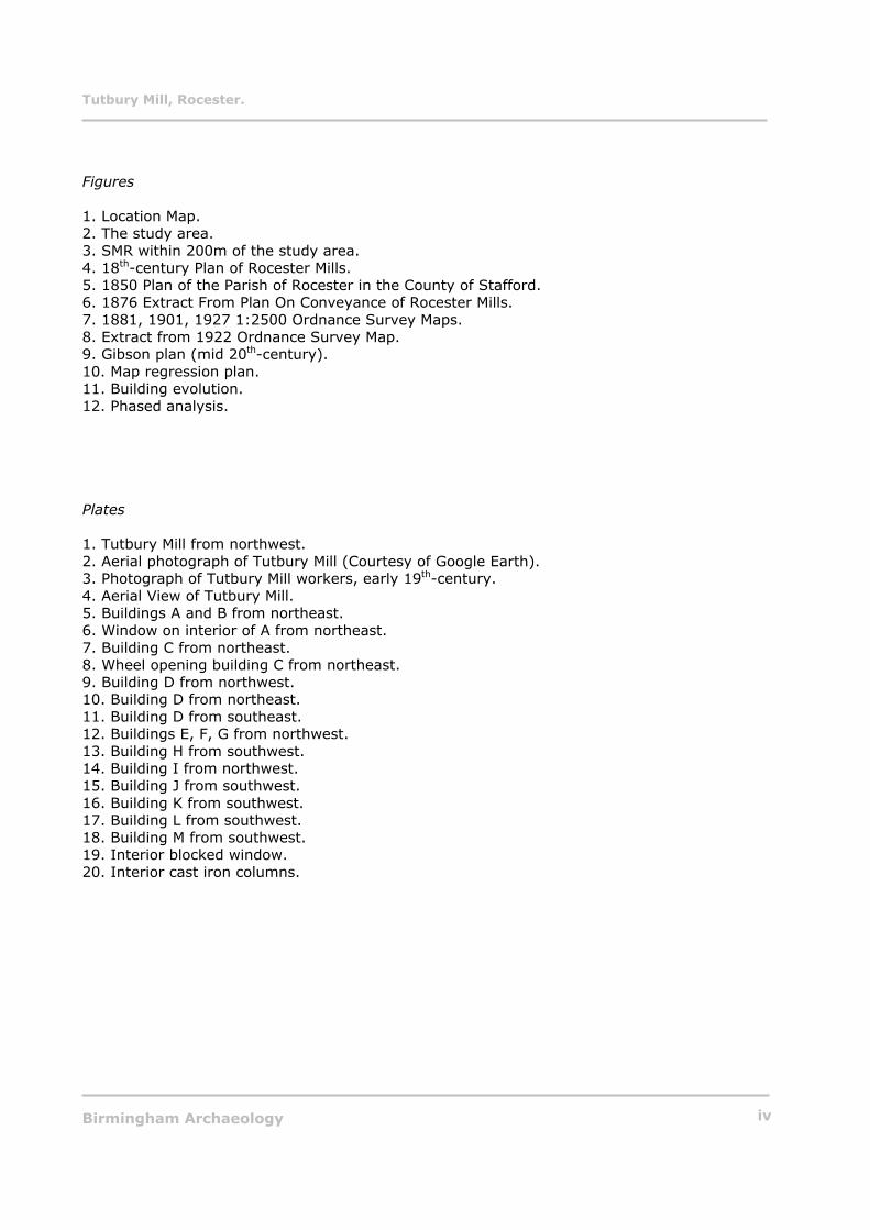
Figures
1. Location Map. 2. The study area. 3. SMR within 200m of the study area. 4. 18th-century Plan of Rocester Mills. 5. 1850 Plan of the Parish of Rocester in the County of Stafford. 6. 1876 Extract From Plan On Conveyance of Rocester Mills. 7. 1881, 1901, 1927 1:2500 Ordnance Survey Maps. 8. Extract from 1922 Ordnance Survey Map. 9. Gibson plan (mid 20th-century). 10. Map regression plan. 11. Building evolution. 12. Phased analysis.
Plates
1. Tutbury Mill from northwest. 2. Aerial photograph of Tutbury Mill (Courtesy of Google Earth). 3. Photograph of Tutbury Mill workers, early 19th-century. 4. Aerial View of Tutbury Mill. 5. Buildings A and B from northeast. 6. Window on interior of A from northeast. 7. Building C from northeast. 8. Wheel opening building C from northeast. 9. Building D from northwest. 10. Building D from northeast. 11. Building D from southeast. 12. Buildings E, F, G from northwest. 13. Building H from southwest. 14. Building I from northwest. 15. Building J from southwest. 16. Building K from southwest. 17. Building L from southwest. 18. Building M from southwest. 19. Interior blocked window. 20. Interior cast iron columns.
Tutbury Mill, Rocester.
Birmingham Archaeology 1
TUTBURY MILL, MILL STREET, ROCESTER. AN ARCHAEOLOGICAL DESK-BASED and HISTORIC BUILDINGS ASSESSMENT, 2006.
1 INTRODUCTION
In November 2006 Birmingham Archaeology carried out an Archaeological Desk-Based and Historic Buildings Assessment of Tutbury Mill, Rocester (SMR 02251-MST2241). The work was commissioned by The Development Planning Partnership on behalf of The Department of Education and Skills in advance of a proposed redevelopment as the JCB Academy.
This report outlines the results of the assessment, which was carried out between the 1st and 14th of November 2006, and which was prepared in accordance with the Institute of Field Archaeologist’s Standard and Guidance for Archaeological Desk-Based Assessment (IFA 1999) and with the Institute of Field Archaeologist’s Standard and Guidance for the Archaeological Investigation and Recording of Standing Buildings or Structures (IFA 2001).
2 LOCATION AND GEOLOGY
The site is located on the north side of Mill Street, on the eastern edge of Rocester, Staffordshire. It is approximately 4 ½ miles northeast of Uttoxeter, and is centred on NGR SK 1128 3923 (Fig. 1) (Plate 1).
The underlying geology consists of alluvial fan and deposits of a higher river terrace (Geological Survey 1983, Ashbourne Sheet 124). Rocester’s soil has been described historically as loam with subsoil gravel (Kelly’s Directory 1896, 292).
The present character of the site is undisturbed grassland with areas of hardstanding surrounding the historic mill buildings (Fig. 2) (Plate 2). To the north of the study area is the former millpond, and West View, a late 19th-century terraced development associated with the mill. To the west are the remains of a Roman fort, within which are the below-ground remains of a 12th-century Augustinian Abbey. To the east, on the east bank of the river Dove is the home ground of Rocester FC. To the south, across Mill Street, is Millholme, the former Mill Manager’s house, which was constructed by 1831.
3 AIMS AND OBJECTIVES
The principle aim of the project was to assess the survival and potential significance of any archaeology within the study area by collating existing archaeological and historical information for the site and its immediate environs. The overall aim of this was to provide the design team with detailed information on areas of historical, archaeological, and architectural significance.
This information will also be used to inform a mitigation strategy for future archaeological work on the site.
4 METHODOLOGY
A search of all relevant and readily available published and non-published documentary sources, including historic maps and photographs, was carried out at Staffordshire Record Office, the William Salt Library, Burton on Trent Public Library local collection, Lichfield Record Office, and the Library of the University of Birmingham. The Staffordshire Sites and
Tutbury Mill, Rocester.
Birmingham Archaeology 2
Monuments Record, the main source of archaeological information for the county was also consulted.
In addition, a walkover of the study area was undertaken to assess the extent and character of existing field monuments (e.g. the former mill pond), and the potential for below ground archaeology.
Furthermore an inspection of the standing buildings was carried out in order to compile analytical descriptions detailing their structural development, to produce a block phase plan, and to assist in assessing the significance of the buildings.
5 ARCHAEOLOGICAL AND HISTORICAL CONTEXT
5.1 Prehistoric
Scatters of prehistoric material have also been found at a number of excavation locations around the village: Late Neolithic and Late Iron Age pottery, and Mesolithic and Neolithic flints were found at the New Cemetery site (Esmonde Cleary and Ferris 1996, 39, 182-183); Mesolithic and Neolithic flints at Dove First School (BUFAU PN592 No Report Produced, 1986); and Mesolithic and Neolithic flints at Orton’s Pasture (SMR EST117) (Ferris, et al 2000, 53).
At Barrow Hill to the north of Rocester, a small Iron Age hill fort has been recorded, and to the south of the village, several known barrows indicate the burial grounds of a settled community. (Gibson 2003, 5).
During building works at the study area in 1792 construction workers uncovered a number of artefacts. Included in these was a now missing bronze axe (SMR 01801-MST1793) (Fig. 3), which is reputed to date from the Bronze Age. In the village of Rocester itself, a complete Bronze Age beaker was discovered during the construction of Northfield Avenue in the 1930s. Subsequent excavations uncovered an early Bronze Age barbed and tanged arrowhead (Burrows 2001).
5.2 Roman
Placename evidence signifies a Roman presence at Rocester. Duignan (1902, 127), Ekwall (1936, 371), Watts (2004, 503), and Horovitz (2005, 462) all note the Anglo-Saxon terminal or suffix ceastre is always indicative of a Roman station or fort. Roman Rocester assumed a relatively important role in the region. It was the intermediate point on the road between Derby and Chesterton, two miles north of Newcastle under Lyme. The village of Rocester has attracted antiquarian interest as a source of Roman coins and pottery since at least the 18th-century, and it is sporadically referred to in antiquarian literature on Uttoxeter and eastern Staffordshire (Esmonde-Cleary and Ferris 1996, 1). Gibson (2003, 9) notes the discovery of Roman artefacts in the Rocester area in 1792, 1833, 1835, 1852, and 1888. The Roman settlement at Rocester covered a wide area and may have comprised several successive sites. The early pottery from the site dates from 60 AD to 100 AD, and it has been suggested that the first fort, which is directly to the west of the study area, was built about 69 AD, during the pacification of the area by Agricola (Greenslade and Stuart 1965, 12). The military occupation ceased about 120 AD and the Rocester area passed into administration. Defences for the civil settlement were added about 160 AD and again about 280 AD. The military garrison was later
Tutbury Mill, Rocester.
Birmingham Archaeology 3
withdrawn and the fort demolished, though a civil settlement continued. As will be noted below, archaeological evidence suggests that the settlement at Rocester continued to grow in the post-Roman era.
5.3 Anglo-Saxon
Onomastic evidence suggests some form of Anglo-Saxon settlement at Rocester. As noted above, the terminal ceastre is an Anglo-Saxon term for a Roman station or fort. The prefix, whilst being almost certainly of Anglo-Saxon origin, is less clear. Most scholars, Ekwall (1936, 371), and Watts (2004, 503), agree that this is probably a derivation of the Anglo-Saxon personal name Hrof, or the modern day Ralph; however, it is possible that it may mean ruhmeaning rough (Horovitz 2003, 462). Webster’s excavation at the New Cemetery in Rocester, c. 250m northwest of the study area, uncovered a late Saxon strap dating to the late 9th-century (1962). Gibson (2003, 18) notes that Rocester would almost certainly have had a Saxon church, which probably underlies the site of the current parish church of St. Michael, 180m to the northwest of Tutbury Mill. Rocester was the demesne of Algar, the earl of Mercia in Edward the Confessor’s time, but William the Conqueror gave it to Robert de Stafford after the conquest (History, Gazetteer, and Directory of Staffordshire 1834, 759). The Domesday Book (1086) recorded that:
Algar held it, 1 hide, with its dependents, land for 9 plough in lordship 2. 18 villagers and 10 smallholders with 9 ploughs. A mill at 10s, meadow 20 acres, woodland 1 furlong, and as wide. Value before 1066 £4, now £8.
5.4 Medieval
Historical accounts of medieval Rocester are dominated by references to the Augustinian abbey. The abbey of St. Mary was founded between 1141 and 1146 by Richard Bacon, nephew of the earl of Chester (Greenslade and Jenkins 1967, 247), and is located directly to the west of the study area, within the Roman fort. No surviving plans of the abbey remain, however inventories following its dissolution in 1538 list that the abbey had amongst other things; “an abbots house, dormitories, kitchens, cloister, laundry, store rooms… a physician, a chapel, a library, and possibly a school (Gibson 2003, 19). There would almost certainly have been further structures on the perimeter of the abbey, to provide for the “practical requirements of everyday life” (Gibson 2003, 19). These would have included stables, pigsties, smithies, carpenters, and most pertinently, a mill. The abbey was well regarded for its production of wool, Pegolotti lists it as one of three wool producing religious houses in North Staffordshire, and estimates that it could produce 10 sacks of wool for sale from its 2,400 sheep. It is quite likely that the abbey’s fulling mill, which may have been located at the study area, was utilised for the production of woollen goods for sale at the abbey’s market, which was in existence at least from 1293 (http://www.british-history.ac.uk/report.asp?compid=37852).
5.5 Post-medieval
There is a paucity of documentary and archaeological evidence relating to the study area following the Dissolution. Richard Arkwright purchased the mills and land in 1781. Sir Richard Arkwright has been universally acknowledged as being one of the most important figures of the Industrial Revolution. He is credited with the invention of the spinning frame, which was powered by horses, in 1769, this was later renamed the water frame following transition to
Tutbury Mill, Rocester.
Birmingham Archaeology 4
waterpower. He built the world’s first water-powered cotton mill at Cromford, Derbyshire in 1771, creating one of the catalysts for the Industrial Revolution. His invention ensured that cotton fibre could be spun into thread. He was initially based in Lancashire, however, the hand-spinning workers, who feared that their means of subsistence would be destroyed by competition from the machine, compelled Arkwright to move to Nottingham, where he entered into partnership with the cotton spinner Jedediah Strutt, the inventor of the stocking frame. The reasons for Arkwright’s decision to locate his cotton mill at Rocester are unclear. He was presumably influenced by the fact that there was a rich tradition of milling in the area, by the readily available skilled workforce, by the ideal location on the strong flowing river Dove, and by the fact that there was already a watermill present on the site (see below).
6 PREVIOUS ARCHAEOLOGICAL WORK
There does not appear to have been any previous formal archaeological work carried out within the study area. However, it must be noted that archaeological remains have been uncovered in the past in this area. Greenslade and Jenkins (1967, 192) and Cockin (2000, 477) note that whilst making the foundations for the cotton mill in 1792 some building foundations were discovered, together with a brass spearhead and some copper coins “much defaced and corroded, which were, however, thought to be Roman”. Human bones and fragments of pottery were also found (Kelly’s 1896, 292). When Richard Arkwright’s weir collapsed in 1943, engineers noticed traces of an earlier and lower weir (Gibson 2003, 77). This was further substantiated by the fact that when, in August 1950, the mill dam was being dredged three lower sections of weir were uncovered, the lowest of which was of “oak framing, pegged and filled with extremely heavy blocks of stone” (Gibson 2003, 77).
There have been a number of previous archaeological interventions/excavations within 200m of the study area. The most significant of these was carried out by Birmingham University Field Archaeology Unit during three separate programmes of archaeological work at Orton’s Pasture, Mill Street, Rocester, between September 1990 and December 1996. These programmes of work were undertaken in advance of a proposed residential development and included an integrated schedule of archaeological evaluation, excavation, field walking, geophysical survey, environmental sampling, and post-excavation analysis. These excavations recorded a sequence of Romano-British activity principally of the late 1st to mid- 2nd century AD. Some less intensive later Roman activity was also recorded in one area of the site. Parts of two adjacent, contemporary enclosures, also contemporaneous with, and probably associated with, the Roman fort complex, which lay to the north of the site, were excavated. Pits inside, and outside the enclosures produced significant quantities of both general and domestic rubbish, in the form of pottery, animal bone and other finds, and more unusual finds, including a fragment from an altar, which suggest that the site may have been the focus of occasional ritual or religious acts. A small stone building in the southern enclosure was identified as a shrine (Ferris et al 2000).
Birmingham University Field Archaeology Unit carried out a number of further programmes of Archaeological excavation and evaluation at Rocester. These, whilst being located more than 200m from the centre of the study area, are important in their contribution to our understanding of the history and development of Rocester. The most significant of these was carried out at the New Cemetery 250m to the northwest of the study area between 1985 and 1987. These excavations uncovered seven phases of activity, beginning with 1st-century AD Roman activity. The remains of three successive Roman forts were uncovered, the last of which was occupied during the Antonine Period (c AD 140-160). The excavations uncovered the remains of an almost complete timber barrack building of this third fort. The archaeological record attests to a civilian centre developing after the abandonment of the fort. There also appears to have been a Saxon presence on the site. It seems that grain processing was
Tutbury Mill, Rocester.
Birmingham Archaeology 5
conducted on site in the 12th or 13th centuries. In the 16th century a smithy was operating nearby (Esmonde-Cleary and Ferris 1996).
The above excavations at the New Cemetery, Rocester, were preceded by earlier excavations carried out by Graham Webster in the early 1960s (Webster 1962). Webster noted the presence of two successive Roman forts with a later Roman civil settlement above them which “stands well in comparison with the smaller towns of Roman Britain” (Webster 1962, 41), in addition to some early-medieval activity.
7 HISTORICAL DEVELOPMENT OF THE STUDY AREA
There is little or no documentary or archaeological evidence regarding the function of the study area in the Roman period, however, as has been alluded to above, Roman and earlier remains have been discovered within the area. Our understanding of the medieval history and development of the site is almost equally as elusive. It is known that at the Dissolution there was a mill at Rocester belonging to the abbey (Greenslade and Jenkins 1967, 217), it is likely that this was located within the study area. Peel (1975, 23) is confident Rocester mills were “almost certainly founded as a corn mill by the Austin Priory at Rocester. At some point a fulling or walk mill existed beside the corn mill, together with kilns possibly used for cloth processing”.
It is possible that the mill buildings shown on the 18th-century plan of Rocester Mills (Fig. 4), were the mills constructed by the abbey. These were presumably then appropriated into private hands after the Dissolution. A closer more in-depth examination of the mill building constructed by Richard Arkwright may demonstrate the partial survival of elements or remnants of these buildings.
Peel (1975, 23) notes that, prior to the Arkwright era, “Rocester mills were continuously being mortgaged by their various owners”. The parish records of 1603 delineate that John Townsend of Marston Montgomery was proprietor of the mills. The property later passed into the possession of William Horsley, who upon his death in 1727, willed them to his grandson John Challoner. On his death in 1758, they were passed on to his daughter Mary, who sold them to another William Horsley of Eaton, Derbyshire in 1773. On the 10th of October 1781 Richard Arkwright, presumably influenced by the recent opening of the Uttoxeter canal, purchased “all that water corn mill and one fulling mill or walk mill commonly known as Rocester Mills together with various properties and water rights on the river Dove” for £820 (Fitton 1989, 61). It is likely that Arkwright dismantled the existing buildings in order to construct his own factory. However, Fitton (ibid) and (Greenslade and Jenkins 1967, 218) claim that he set about “converting the mills for cotton spinning”. Arkwright also paid £412 for 1575 sq yards of adjacent fields in order to widen the wheel race. This enabled him to install two water wheels, one internal and one external; the stone arches on either side of the mill at sluice level, probably covered the internal wheel (Gibson 2003, 67). Peel (1975, 22) claims that these would possibly not have been powerful enough to run the operation, however Gibson notes that such comments would fly in the face of Arkwright’s ability and knowledge (Gibson 2003, 67). In January 1783, Arkwright sold Rocester Mills to his son Richard Jr for £3000 (Fitton 1989, 61). Richard Jr, who had learnt his trade at Cromford Mill, Derbyshire set about constructing a new extension to help meet the growing demand for Arkwright’s cotton products. The interior wheel was “removed and the arches sealed, along with all the openings on the eastern elevation. The original wheel at the end of the mill remained and the dam was extended to feed the two additional wheels built by Hewes in the new wing” (Gibson 2003, 67).
Tutbury Mill, Rocester.
Birmingham Archaeology 6
In January 1786 he sold a one third share of his mill to Richard Bridden, who had been clerk to Arkwright Jr at Bakewell. Bridden’s share cost him £3228 14s, which included £1500 as a premium to enter into co-partnership. He was also to receive £25 a year for superintending the mill (Fitton 1989, 61). This partnership lasted until 1806 when Bridden assumed full ownership of the enterprise which was now valued at £34,773 (Fitton 1989, 61). Bridden oversaw a further extension to the mill building in response to further increases in demand in the build up to the Napoleonic wars.
When Bridden died in 1814, the majority of his estate was passed to his eldest son Samuel; his other son Joseph, and Samuel and Richard Simpson were named trustees of the mill. It appears that the family had little interest in the mill until in March 1825, when Francis and John Bridden took out a long-term lease on the property (Pigots Directory 1828-29, 742). It would appear that their enterprise was not a success as the mill was offered for sale in the Staffordshire Advertiser on the 23rd of July 1831:
“To be sold by private treaty or to be let Rocester Cotton Mills and Waterfalls- Together with an excellent dwelling house, offices, out buildings and grounds, pleasantly situated a short distance from the works, and fitted up for the residence of a genteel family, two other Dwelling houses, and garden, suitable for managers or foreman and 39 cottagers, also about 120 acres of the richest meadowland on the banks of the river, and partly adjoining the house.
The mills are good substantial brick buildings, now fitted with throstle spring machinery, all of which, or any part thereof, may be taken by the purchasers.
The machinery is turned by 3 excellent waterwheels (2 made by Hewes) and supplied by the whole stream of the river Dove, which at all seasons of the year produces an effective force, equal to 70 horses power, with weir floodgates, and breastwork for the wheels, all substantially set in stone and a considerable part of the heavy machinery is nearly new- premises have all these decided advantages for manufacturing purposes, are seldom, if ever, offered to public”.
Gibson claims that one possible explanation for the mill’s failure was a lack of investment in equipment at a time when there was a rush to install throstles, a modern and more efficient form of the water frame (2003, 68). This may be the reason that no one was willing to take on the mills until January 1833, when Thomas Houldsworth, a Lancashire spinner, the highest bidder at a sale held at the Cock Inn, purchased the mills and paid off the mortgage (Gibson 2003, 68). The mill was now employed in “doubling lace thread” (History, Gazetteer, and Directory of Staffordshire 1834, 759). In 1832 the mill contained 133 carding machines and 7,151 spindles, and in 1833 a beam engine was installed at the mill (SMR 02251-MST2241). In 1836 Houldsworth proceeded to extend his property at Rocester by purchasing surrounding land from James Blair a local landowner. By 1850 the mill was “employing about 270 hands” and was managed by James Nicholson (Post Office Directory of Birmingham, Staffordshire, and Worcestershire 1850, 301). The 1850 tithe map (Fig 5) delineates that Thomas Houldsworth was the landowner, Thomas Hudson was the occupier and probable manager of the cotton mill, and James Leadbitter was the occupier of the foreman’s house M (Fig 10). Houldsworth’s purchase and venture seems to have been profitable as he retained the mill until he died in 1852. Upon his death, his mills at Manchester and Rocester were jointly valued at £110,616. His Rocester property was divided out amongst his family, his nephew Henry Houldsworth bought out the others and took control of the enterprise. Henry turned out to be both a “benefactor and a sound businessman” (Gibson 2003, 68). He consolidated the land around
Tutbury Mill, Rocester.
Birmingham Archaeology 7
the mill into one lot by swapping various fields with his neighbours. He was allegedly responsible for the building of the village school in 1852, and in 1854, and is said to have built houses on West View Road and on High Street to accommodate his workers, however, these houses do not appear on the 1876 or 1881 maps. In the early 1860s further land sales and purchases resulted in the boundaries recognisable today taking shape (Plate 4). Henry Houldsworth died in 1868 leaving his property and business to his son William Henry, who resided over one of the darkest moments in Rocester’s history. At this stage George Kay was manager (Census 1871). Poor working conditions, industrial disputes, and unhappy employees led to William Henry closing the mill in 1876, almost 400 inhabitants of Rocester became unemployed, and most of the machinery was sold to the cotton mill at Mayfield.
The mill remained vacant until 1876 when Walter John and Charles William Lyons, the proprietors of the cottons mills at Tutbury, purchased it (Fig. 6). They were obviously not keen to sever their ties with Tutbury and renamed the Rocester operation ‘The Tutbury Mills’. By 1881 Moses Fearn was installed as the mill manager (Census 1881), and his brother John was secretary of the company (Kelly’s Directory 1896, 292). The Tutbury Mill Company invested heavily at Rocester. In 1878 they took out a mortgage to finance replacing the old waterwheels with vertical water turbines by McAdams of Belfast. A new wing was built after 1881 (Fig. 7) and a new engine was installed a few years later. Steam boilers were added in 1887 and in 1889, a gas producing plant was also constructed. By 1896 the mill was employing “around 350 hands” (Kelly’s Directory 1896, 292) (Plate 3). In that year Charles William retired and the mill became a limited company with Walter John the majority shareholder. This was an ill-advised move as in 1900 the company went into voluntary liquidation and was taken over by Boden and Co. lace manufacturers of Derby. The indenture which records this change in ownership describes the individual parcels of land, this lists the various structures and work areas present in the study area at that time including: cotton mill, outbuildings, engine-house, wood-yard, gasworks, gearing, mill dams, stables etc (Fig 7). In 1906 the Fine Spinners and Cotton Doublers Association Limited purchased this company and “ran it successfully for many years” (Gibson 2003, 78) (Figs. 7 and 8). In the 1940s producing enough power became an acute problem at the mill, in 1943, Arkwright’s weir collapsed and the turbines were unable to function, “the steam engines failed, and the electricity installed in 1905 began to malfunction” (Gibson 2003, 78). This problem was resolved in 1947 when the plant was converted to mains electricity, and the gas plant was closed in 1948. The turbines “colloquially known as Oxford and Cambridge” (Gibson 2003, 78) were disposed of. In 1943 a massive fire almost destroyed the mills, and resulted in a new roof being built on block L (Peel 1975, 28). In 1964 the mill was purchased by Courtaulds Ltd., who continued producing textiles and yarns at the site until the mid 1980s.
The mill is currently in use as a storage depot for the Bamford family.
This history of the development of the study area provides an excellent understanding of the continuity of function at the site. The manufacturing of textiles seems to have been the chief concern here from at least the medieval period, it is likely that the medieval abbey had a mill here for the processing of woollen goods, there was a post-medieval cloth mill on the site, and Richard Arkwright introduced the processing of cotton to the area in 1781, a tradition which lasted at least until the 1830s when the mill was used for doubling lace thread. This association with textiles continued until towards the end of the 20th-century, and may have stretched back further than the medieval period.
Tutbury Mill, Rocester.
Birmingham Archaeology 8
8 BUILDING DESCRIPTIONS
Please refer to Figs. 9 and 10.
A. (Plate 5 and 6) This is a mid-19th-century gable-ended, one-storey structure with one bay on each of its sides. It is of red brick measuring 8 ¾ ins x 3 ins x 4 ¼ ins which is laid in English bond. The plinth is of splayed blue brick. There are segmental arch windows and Oeil de Bouef windows (now blocked) towards the apex, on each gable end. The segmental arched doorway on the northeast-facing elevation has been cut by a concrete lintel. The eaves are plain and there is a slate roof. It is evident that this building postdates B as there is a blocked keystone- type window in the interior. The original function of this building is unclear, however, it was in use as a wood store in the mid 20th-century (Fig 9).
B. (Plates 5 and 6) B (northwest) This is an early 19th-century, one-storey one-bay structure. It is of red brick measuring 9 ins x 2 ¾ ins x 4 ½ ins laid in a random bond. There is a polygonal brick chimney at the western corner; the window has a stone sill and slightly segmental headed windows with painted shaped lintels and raised keys. The pan-tiled roof is hipped. B (southeast) is similar, however it has two-storeys and two-bays and is laid in English Garden Wall bond. The lower windows are partly obscured by ground level. It has a flat roof with stone coping. It is obvious from a straight joint that this structure abuts C, and as noted above, it predates A. Whilst the original function of this building is unknown, it was being used as a garage in the mid- 20th-century (Fig. 9).
C. (Plates 7 and 8) The northeast facing elevation of this late 18th-century structure has four storeys and twelve bays. This is of red brick laid in a stretcher type bond with occasional headers measuring 8 ¾ ins x 2 ½ ins x 4 ¼ ins. The lower three floors have similar windows to B; the upper floor windows have square heads, the lintels forming part of the eaves band. There is a brick buttress, in the form of a porch, covering bays 10 and 11 to the northwest, this has a slate roof and affords entrance to this block through a segmental arch doorway. At the lower floor of the southeast end of this elevation are waterwheel openings in round arches; these are now filled in with fenestration. There is an ornate cast iron fire escape to the east. A large water tower with copper basin and recessed decoration and diapered brickwork has been constructed above this block roof. This was originally built as a mill building; however, by the mid 20th-century it was being used as an engine and winding house, and a pump house (Fig. 9).
D. (Plates 9, 10, and 11) This late 18th-century fourteen-bay, four-storey elevation is similar to the northeast elevation of building C. This is of red brick laid in a stretcher type bond with occasional rows of headers. The windows at ground floor level have been blocked. A painted sill string forms the sills for this row of windows, which are similar to those on C. Blocked stone arches at ground level may have been further wheel or turbine arches. It is clear from the straight joint between D and C, that D is older. The tower rising from the west corner is a more recent addition. The northeast facing elevation is double gable ended with kneelers and a filled-in valley gutter. There is an ornate cast iron fire escape providing access to the doors on the north-western side of this elevation. This elevation is of red brick laid in stretcher bond with occasional headers. The windows to east have similar heads to the rest of the block. The
Tutbury Mill, Rocester.
Birmingham Archaeology 9
southwest elevation is the same as the northeast apart from the absence of doors. The southeast elevation has stone quoins demarking its most southerly bay. It has four storeys and twenty-five bays. The ground floor is of cut ashlar type stone and has stone arches similar to that on the western elevation. There is a four storey, two bay toilet block between bays eleven and thirteen. This was originally constructed as a mill building; however, by the mid 20th-century it was in use as a gassing, and winding and reeling building (Fig. 9).
E. (Plate 12) This is a late 19th-century one-bay, one-storey gable ended structure with slate roof. It is of red brick measuring 8 ins x 2 ins x 4 ¼ ins and laid in English bond. The door to the southwest side appears to be cut by F but is not, it is clear however that E is blocking a semicircular arch on F. The original function of this structure is unknown.
F. (Plate 12) The northwest facing elevation of this late 19th-century structure is partially blocked by E. The upper storey is modern alteration/ addition. The chimney mentioned in B is located at the south corner. This building was utilised as a boiler house.
G. (Plate 12) The northwest facing elevation of this late 19th-century block has a low brick wall laid in English bond, above which is timber planking. The southwest elevation is red brick laid in stretcher bond and contains blocked windows and a doorway. The southeast elevation consists of two half gables. This structure was also used as a boiler house.
H. (Plate 13) This late 19th-century structure abuts G to the southwest. It is of red brick laid in English bond measuring 9 ins x 2 ins x 4 ins. Its windows and doors have segmental arch heads and stone sills; there are four bays to southwest and one bay to the northwest. There are two doorways to the southeast. This block has a slate pitched roof with oversailing eaves. This building was utilised as a mechanics and joiners shop.
I. (Plate 14) The northwest facing elevation of this early 19th-century block has four storeys and eleven bays. It is of red brick laid in English Garden Wall bond measuring 9 ins x 2 ¾ ins x 3 ins. The most northerly ten bays all have flat-headed stone/concrete heads. These have stone sills, there are alternating stone quoins at each corner. This elevation abuts the side of C. The eleventh bay to the southwest is a later addition; it is similar to the toilet block on D. It is of red brick laid in English Garden Wall bond measuring 8 ins x 2 ¾ ins x 4 ins, it has a blue brick sill/plinth at ground floor level. The windows are camber headed with stone sills. It has stone eaves and ornamentation. The southwest elevation is largely blocked by J. This block was utilised as a mill building and offices.
J. (Plate 15) This late 19th-century structure is of red brick laid in Flemish Bond and has stone quoins and ornamentation, and multipaned windows. There is a stone plaque on the south elevation reading The Tutbury Mill Company Limited. This was used for administrative offices.
K. (Plate 16) The twin gabled southwest elevation of this late 19th-century block has four storeys and six bays. It is of red brick laid in English Garden Wall Bond. It has segmental arch windows and blue brick strings which also form the sills. This building was used as a mill.
Tutbury Mill, Rocester.
Birmingham Archaeology 10
L. (Plate 17) This late 19th-century building is of red brick of varying bond patterns, with stone plinth and strings. This is devoid of fenestration on all elevations apart from the north, which has three bays of square-headed windows. The gabled roof is of asbestos. The original function of this building is unclear, however it was used as a waste and yarn store by the mid 20th-century (Fig. 9).
M. (Plate 18) This is a two-storey, one-bay house of painted red brick, with kneeler gables and dentilated eaves. It is possibly of a late 18th-century date. It was used as the mill foreman’s house; it may have been used as the mill manager’s house prior to the construction of Millholme in 1831 (SMR 08854-MST8518).
There are a number of interesting features in the interior; these include several blocked doorways and windows (Plate 19) relating to the numerous additions and phases of construction. There are also interesting cast-iron columns supporting large timber beams in parts of the interior (Plate 20). There are a number of pieces of machinery related to the textile trade in parts of the interior, however it is unlikely that these are in-situ or original to the building.
9 STRUCTURAL PHASING
There were seven distinct phases of construction, additions, and alterations (Figs. 10, 11, and 12).
Further in-depth and detailed investigation, and archaeological recording should provide a better understanding of the built history of the Tutbury Mill at Rocester. This would help create an understanding of issues such as process flow, room function, internal spatial organisation and layout, structural changes and alterations, and the reasons behind the construction of successive phases.
9.1 Phase 1: 1781
Block D represents the first phase of construction. This was the cotton mill constructed by Richard Arkwright in 1781. It is likely that the earlier mills extant in the study area at this time were cleared for the erection of this edifice. However, it is possible that remnants of these remain within the present structure. The stone wheel arches on either side of this building may survive from these earlier mills, however further investigation and recording would be necessary argue this case. M the mill foreman’s house, and parts of L may have been constructed at this time.
9.2 Phase 2: 1783
Block C represents Phase 2 of construction at the study area. Richard Arkwright Jr built this after purchasing the mills from his father in 1783. Significantly and interestingly, he chose to imitate the architectural style his father had used in the earlier building.
9.3 Phase 3: early 19th-century
The third phase of building at the study area was constructed by the Bridden family sometime after their acquisition of the mills in 1806. Block I was built at a time when demand for cotton was increasing in the build up to the Napoleonic wars. Millholme, the mill manager’s house to the south of the study area was constructed in 1831.
Tutbury Mill, Rocester.
Birmingham Archaeology 11
9.4 Phase 4: 1850-1872
This phase saw the construction of a number of ancillary buildings A, E and F to the northwest of the main mill buildings. It also saw the erection of a now removed gasworks and shed in this area.
9.5 Phase 5: 1872-1881
Phase 5 saw further ancillary buildings G and H being constructed to the south of the phase 4 structures.
9.6 Phase 6: 1881-1901
This phase represents the additions and alterations exacted by the Tutbury Mill Company. Buildings K and L were added in a phase that proved to almost complete the building footprint that presently exists at the study area.
9.7 Phase 7: 20th-century
This phase saw the construction of toilet blocks at the southwest corner of I, and to the east of D. A brick buttress was built along the north wall of C, whilst an electrical substation was built to the southwest of the study area. A fire in the 1950s saw the insertion of an asbestos roof above building L.
10 ARCHAEOLOGICAL POTENTIAL AND SIGNIFICANCE
Previous archaeological excavations and interventions in the Rocester area have produced outstanding results. The level of survival and preservation of the archaeological record has been of an exceptionally high quality. In addition, the excavation at Orton’s Pasture, directly to the southwest of the study area, yielded excellent environmental preservation (Richard Cuttler pers comm). These previous excavations have shed light on the history of human occupation and settlement at Rocester dating back to the Mesolithic period (8000 BC – 5000BC). There is no reason to believe that any future archaeological intervention at the study area would diverge from this pattern. It has already been noted that documentary records attest to items of archaeological importance and significance being discovered at the site. Any future archaeological work in this area would enhance our understanding of the development of Rocester, and in particular, would illuminate and illustrate our comprehension of activity on the outskirts of the Roman defences, and within the immediate environs of the Augustinian Abbey. It may also inform our understanding of the site after the Dissolution, and possibly uncover evidence of the water and fulling mills on the site prior to the Arkwright era. A walkover survey and aerial photography (Plate 2) of the field in the northern portion of the study area exhibited some bumps and hollows which may have some archaeological potential and significance. Remote Sensing LIDAR data also delineates some topographical variations in this area (Courtesy of Keith Challis). Environmental analysis of the millpond in this northern area of the site, which is probably demarcated by a group of trees (Emma Tetlow pers comm.) (Plate 2), may also prove of some benefit in enhancing our understanding of the medieval and post-medieval activities within the study area.
This site is potentially very archaeologically significant, it is on the outskirts of a Roman fort and civil settlement, it is within the immediate environs of a medieval abbey, it is possibly the site of a medieval mill, and contains structures built by and associated with Richard Arkwright, one of the key personalities and catalysts of the industrial revolution.
Tutbury Mill, Rocester.
Birmingham Archaeology 12
11 SIGNIFICANCE OF THE BUILDINGS
This cursory assessment has shown that Tutbury Mill is of national significance, being a grade II listed building within a Conservation Area.
PPG15 (1994) sets out strict criteria for deciding which buildings merit inclusion on the statutory lists: -
-architectural interest: the lists are meant to include all buildings which are of importance to the nation for the interest of their architectural design, decoration and craftsmanship; also important examples of particular building types and techniques (e.g. buildings displaying technological innovation or virtuosity) and significant plan forms;
-historic interest: this includes buildings which illustrate important aspects of the nation’s social, economic, cultural or military history;
-close historical associations with nationally important people or events;
-group value, especially where buildings comprise an important architectural or historic unity or a fine example of planning (e.g. squares, terraces or model villages).
Not all these criteria will be relevant to every case, but a particular building may qualify under more than one of them.
It is without doubt that this collection of buildings contributes greatly to the appeal of Rocester and its surrounding landscape. Dominating the vistas in this part of the village, the mill is of undoubted is of architectural interest, both form a functional viewpoint as a large scale industrial building, and from an aesthetic stance with its with its symmetrical elevations of classical pretensions. Its association with Richard Arkwright ensures that it is also of national historic interest. Any alterations should be carefully, tactfully, and sympathetically considered. As a grade II listed building it is “of special interest, warranting every effort to preserve” it (http://www.heritage.co.uk/apavilions/glstb.html). However, as will be outlined below, a more thorough examination of the buildings is required to fully understand the built history of the site. Such a programme of building recording would assist in our appreciation of the phases of construction and of the significance of the building.
12 CONCLUSIONS AND RECOMMENDATIONS
The above assessment delineates that the study area is of historical, archaeological, and architectural significance. The site itself is located in close proximity to a Roman fort and civil area, within which lies the remains of the 12th-century Augustinian abbey of St. Mary. It is highly probable that the study area, due to its propinquity, assumed some function relating to these important sites. This is further attested to by the documentary evidence, which suggests that items of historical and archaeological interest and significance have been uncovered within the study area in the past. It has also been noted that previous archaeological work near to the study area has uncovered evidence for human occupation of this particular locale dating back to the Mesolithic period.
With regard to the built heritage, the first phase of the mill building was constructed by Richard Arkwright, one of the most important figures of the Industrial Revolution. The subsequent phases of construction were all associated with the manufacturing and processing of textiles: a
Tutbury Mill, Rocester.
Birmingham Archaeology 13
continuity of tradition in the study area that may date back at least to the 12th-century abbey, if not earlier.
It is highly likely that any future programme of renovation, new build, or demolition at the study area would impact or impinge upon the significance of the site. It is recommended that a programme of archaeological excavation or evaluation be carried out prior to any of these works. It would be difficult to propose any particular areas in which to carry out this work, as due to the significance of the study area and to its proximity to other important sites, the whole area should be treated as archaeologically significant. Therefore, it would be more cogent to recommend that the design of any future construction on this site should be taken into account when devising a strategy for archaeological survey and intervention.
With regard to the built heritage it is recommended that a programme of historic building recording should be carried out prior to any future alterations or additions. This should be carried out to at least Level 3 standard (RCHME 1996, English Heritage 2006) in order to gain a more in-depth and enhanced understanding of the various phases of construction at the site. This in turn would help to focus upon particular areas in which future new builds/ additions could be positioned in order to least affect and compromise the significance of the structures.
13 ACKNOWLEDGEMENTS
The project was commissioned by The Development Planning Partnership, on behalf of The Department of Education and Skills. Thanks are due to Katy Lightbody of The Development Planning Partnership and to Nick Hague of Burofour for their co-operation and assistance throughout the project. Thank you also goes to Steve Ovens of JCB for providing access to their records and deeds. Thanks are also due to Roger Austin, caretaker, Rocester Mill. Thanks also go to Keith Challis, Richard Cuttler, and Dr Emma Tetlow of Birmingham Archaeology for their specialist advice. The assessment was undertaken by Shane Kelleher. Shane Kelleher produced the written report, which was illustrated by Nigel Dodds, and edited by Malcolm Hislop who also monitored the project for Birmingham Archaeology.
Tutbury Mill, Rocester.
Birmingham Archaeology 14
14 SOURCES
14.1 Primary Sources
1565-1705 Rocester Parish Records, Burton on Trent Public Library local collection.
1828/29 Pigot and Co. Directory of Cheshire, Cumbria…[Part 2:Notts-York & North Wales].
23/07/1831 Staffordshire Advertiser.
1834 History, Gazetteer, and Directory of Staffordshire.
1850 Post Office Directory of Birmingham, Staffordshire, and Worcestershire.
1871 Census Returns from Rocester RG10/2892, Stafford Record Office.
1881 Census Returns from Rocester RG11/2749, Stafford Record Office.
1896 Kelly’s Directory of Staffordshire.
Deeds relating to Tutbury Mills, Rocester. Access Provided by JCB.
14.2 Secondary Sources
Burrows, B 2001 Archaeological Evaluation of Northfield Avenue, Rocester, Birmingham, Birmingham University Field Archaeology Unit. Report No. 839.
Cockin, T. 2000 The Staffordshire Encyclopaedia, Stoke-on-Trent, T Malthouse Press.
Department of the Environment (DoE) 1990 Planning Policy Guidance Note 16: Archaeology and Planning.
Department of the Environment (DOE) 1994 Planning policy Guidance Note 15: Planning and the Historic Environment.
Duignan, W.H. 1902 Staffordshire Place Names, London, Oxford University Press.
Ekwall, E 1936 Oxford Dictionary of English Placenames, Oxford, Oxford University Press.
Esmonde-Cleary, A.S. and Ferris, I.M. 1996 Excavations at the New Cemetery, Rocester, Staffordshire, 1985-1987. Staffordshire Archaeological and Historical Society Transactions 1993-1994. 35.
English Heritage 2006 Understanding Historic Buildings: A Guide to Good Recording Practice.
Ferris, I.M, Bevan, L. and Cuttler, R. 2000 The Excavation of a Romano British Shrine at Orton’s Pasture, Rocester, Staffordshire, Birmingham, Birmingham University Field Archaeology Unit, British Archaeological Reports BAR 314.
Fitton R.S. Fitton 1989 The Arkwrights Spinners of Fortune, Manchester, Manchester University Press.

Tutbury Mill, Rocester.
Birmingham Archaeology 15
Gibson, A 2003 A History of Rocester, Churnet Valley Books.
Greenslade, M.W. and Jenkins, J.G. 1967 The Victoria History of the County of Stafford Vol 2, London, Oxford University Press for the Institute of Historical Research.
Greenslade, M.W. and Stuart, D.G. 1965 A History of Staffordshire, Beaconsfield, Darwen Finlayson.
Greenslade M.W. and Stuart, D.G. 1984 A History of Staffordshire, Chichester, Phillimore and Co. Ltd.
Horovitz, D. 2005 The Placenames of Staffordshire, Brewood, Horovitz.
Institute of Field Archaeologists (IFA) 1999 Standard and Guidance for Archaeological Desk-Based Assessment, rev. edn.
Institute of Field Archaeologists (IFA) 2001 Standard and Guidance for the Archaeological Investigation and Recording of Standing Buildings or Structures rev. edn.
Peel, F. 1975 The History of Arkwright’s Mill, Rocester Journal of the Staffordshire Industrial Archaeology Society 6.
RCHME 1996, Recording Historic Buildings: A Descriptive Specification, 3rd edn.
Thompson, W.J. 1975 Industrial Archaeology of North Staffordshire Buxton, Moorland Ltd.
Watts, V 2004 The Cambridge Dictionary of English Placenames, Cambridge, Cambridge University Press.
Webster, G 1962 Excavations on the Roman Site at Rocester, Staffordshire, 1962, NorthStaffordshire Journal of Field Studies, II, 37-52.
14.3 Cartographic Sources
18th-century Plan of Rocester Mills, William Salt Library M900.
1850 Plan of the Parish of Rocester in the County of Stafford.
1876 Extract From Plan On Conveyance of Rocester Mills.
1881 Ordnance Survey Map 1:2500 Staffordshire Sheet XXVI.3.
1901 Ordnance Survey Map 1:2500 Staffordshire Sheet XXVI.3.
1922 From Ordnance Survey Map 1:2500 Staffordshire Sheet XXVI.3.
1927 Ordnance Survey Map 1:2500 Staffordshire Sheet XXVI.3.

Tutbury Mill, Rocester.
Birmingham Archaeology 16
14.4 Internet Resources
http://www.british-history.ac.uk/report.asp?compid=37852 Consulted 9:15 03/11/06.
http://www.heritage.co.uk/apavilions/glstb.html Consulted 10:20 03/11/06.
Tutbury Mill, Rocester.
Birmingham Archaeology 17
Appendix 1
Historic Map Regression and Analysis
18th-century Plan of Rocester Mills. (Fig. 4) This plan shows two buildings; one a water mill, the other is possibly a fulling mill, there is a kiln located to the west, these are situated in an area known as Mill Green. The surrounding area is owned by Thomas Bainbrigge Esq. The land to the north of the mill is called little Rings or Little Briggs, and Hen Walk.
1850 Plan of the Parish of Rocester in the County of Stafford. (Fig. 5) This plan shows the new cotton mill building, which is of an inverted T shape with a western offshoot on the stem. Shows the mill foreman’s house and Millholme, the mill manager’s house.
1876 Extract From Plan On Conveyance of Rocester Mills. (Fig. 6)This is similar to 1850 but with three offshoots and a gas plant added to the north. It is annotated Rocester Mills, and delineates the milldam to the north. West View is not shown.
1881 Ordnance Survey Map 1:2500 Staffordshire Sheet XXVI.3. (Fig. 7)This is annotated Cotton Mill, and shows additional offshoots to the north and south. The millpond is marked to the north and is located to the west of an osier bed. West view is not shown.
1901 Ordnance Survey Map 1:2500 Staffordshire Sheet XXVI.3. (Fig. 7)This is annotated Cotton Mill. The infilling building work to the south is quite evident, as the mill begins to take its present plan shape. The millpond is marked to the north.
1922 From Ordnance Survey Map 1:2500 Staffordshire Sheet XXVI.3. (Fig. 8)This is annotated Tutbury Mill. This shows further additions to the west of the north offshoot.
1927 Ordnance Survey Map 1:2500 Staffordshire Sheet XXVI.3. (Fig. 9) No further changes to the 1922 map.
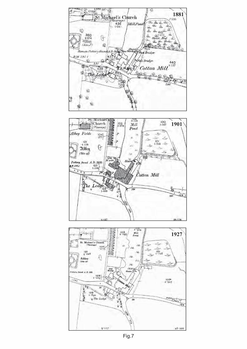
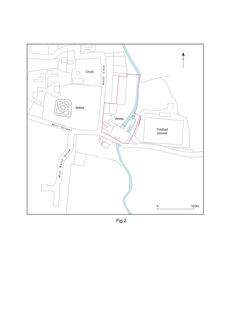
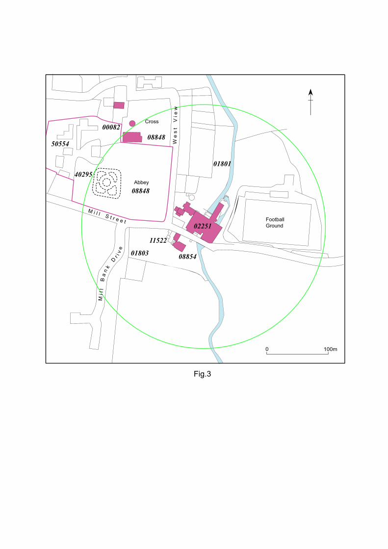
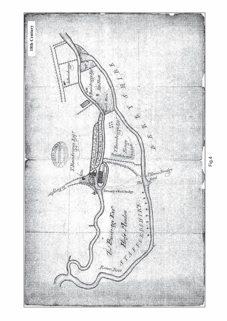
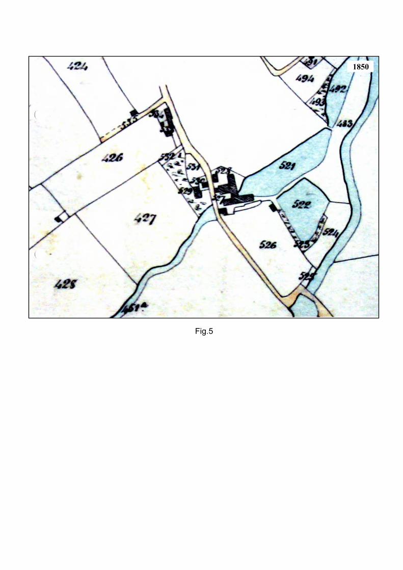
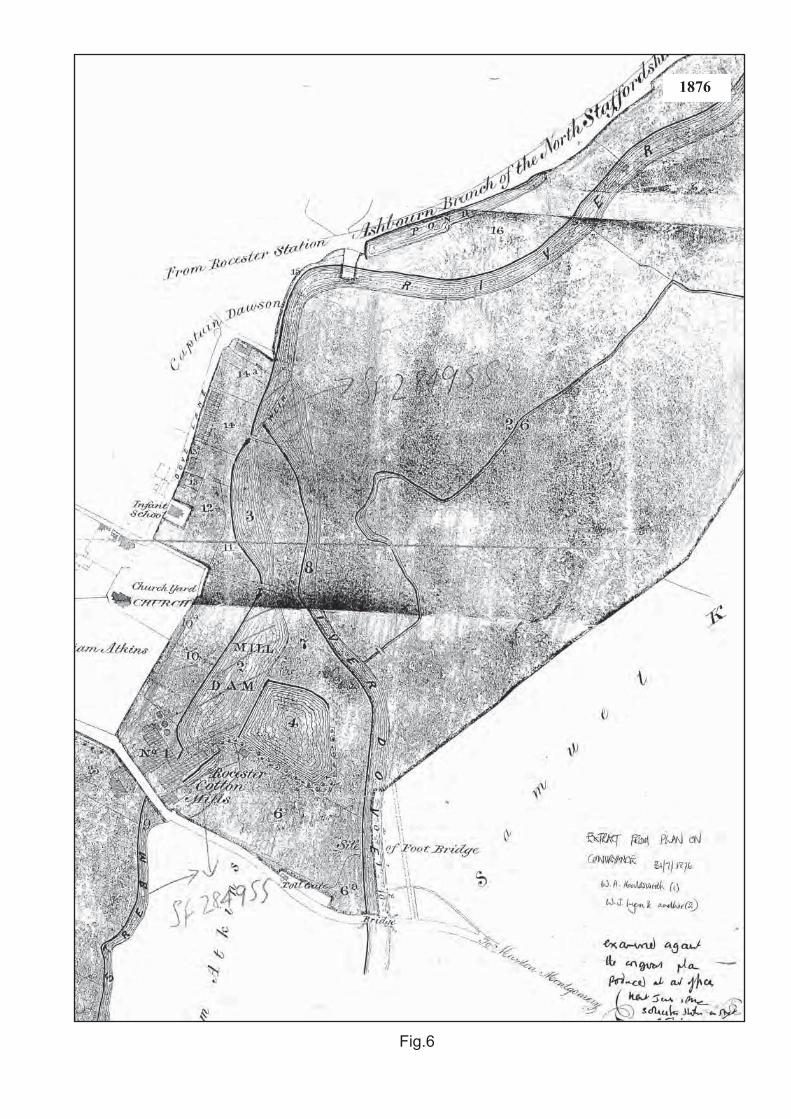
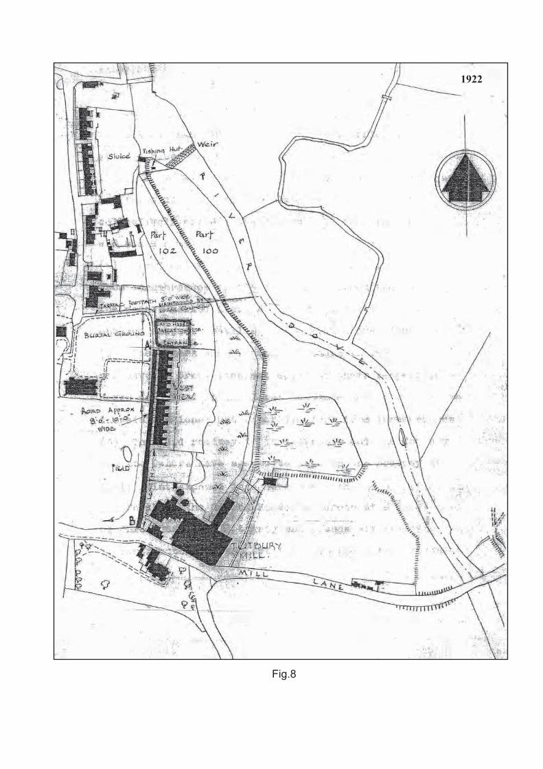
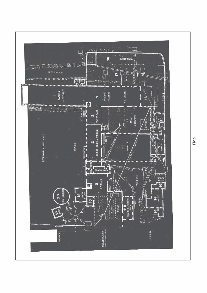
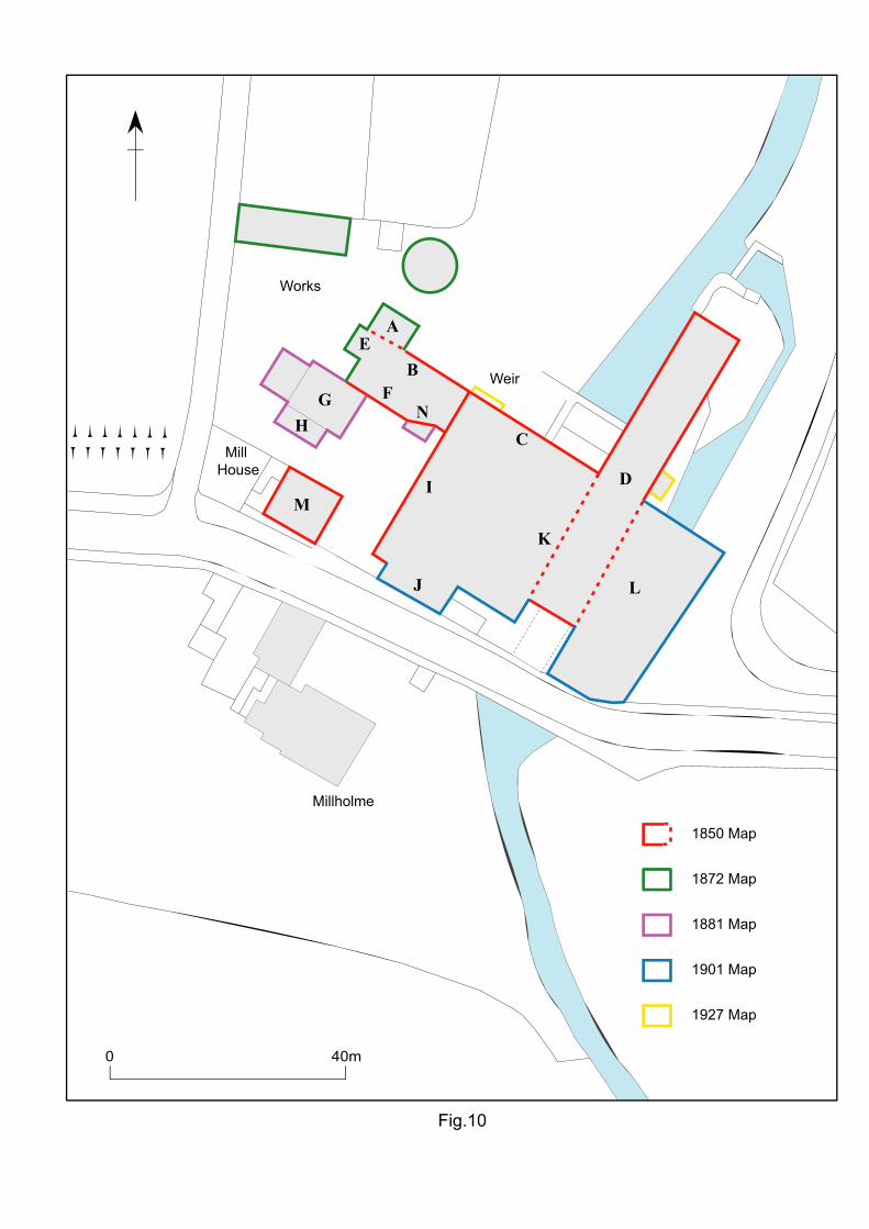
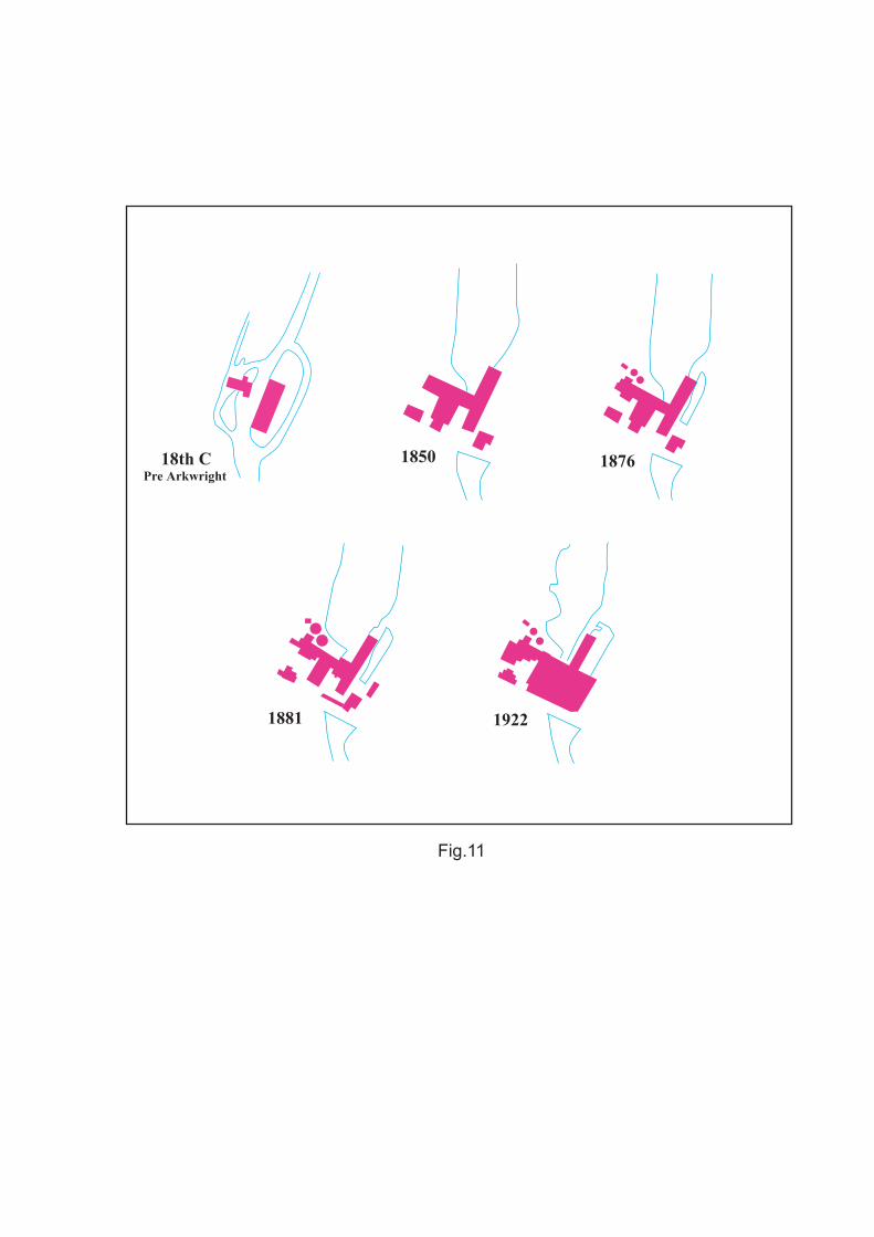
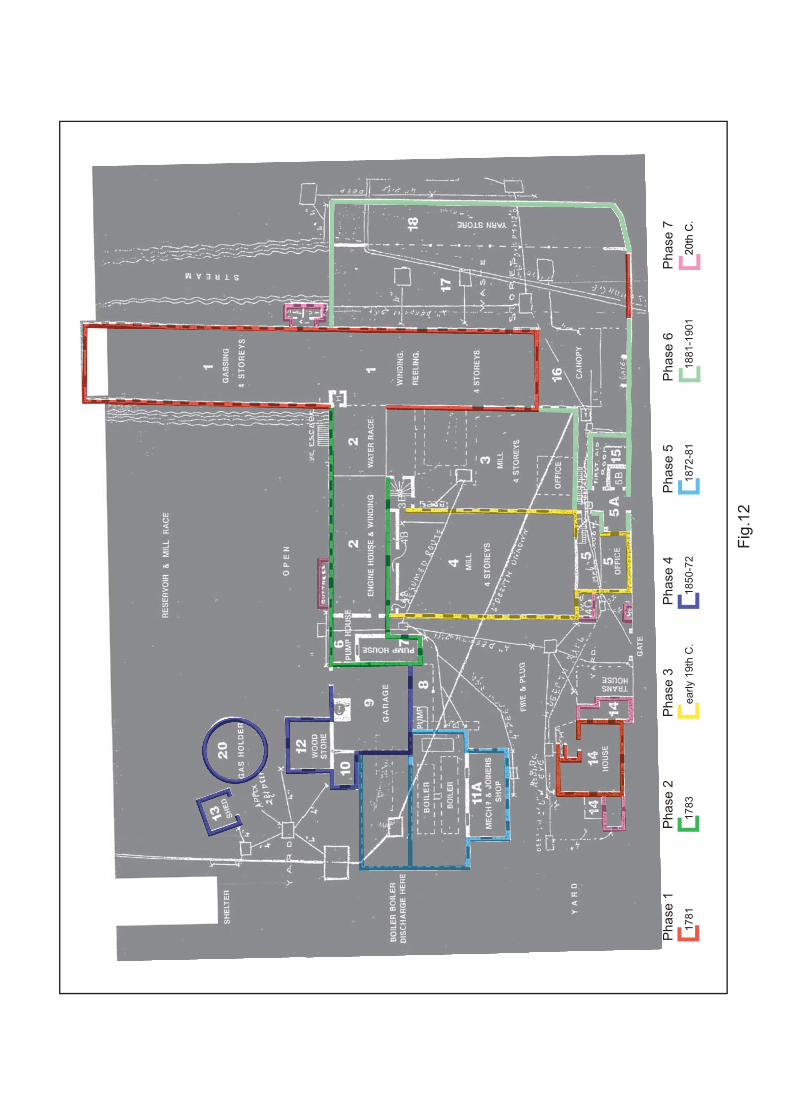
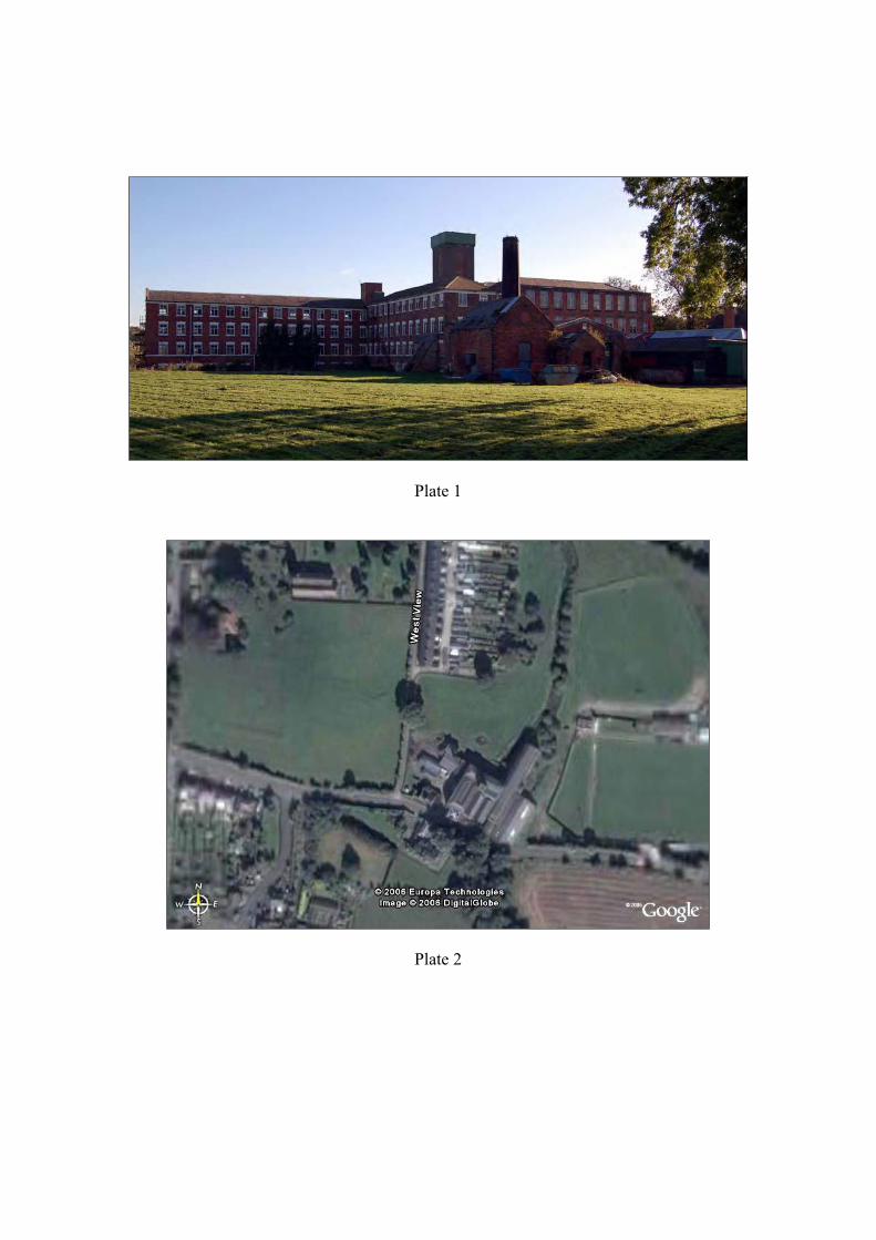
Plate 1
Plate 2
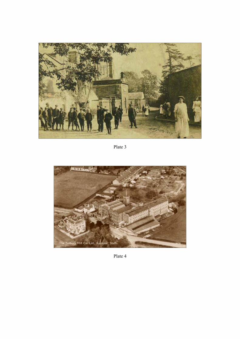
Plate 3
Plate 4
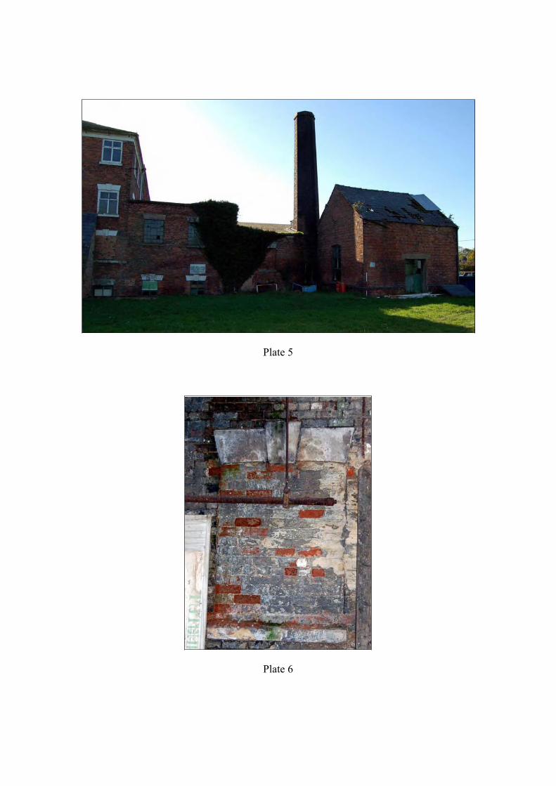
Plate 5
Plate 6
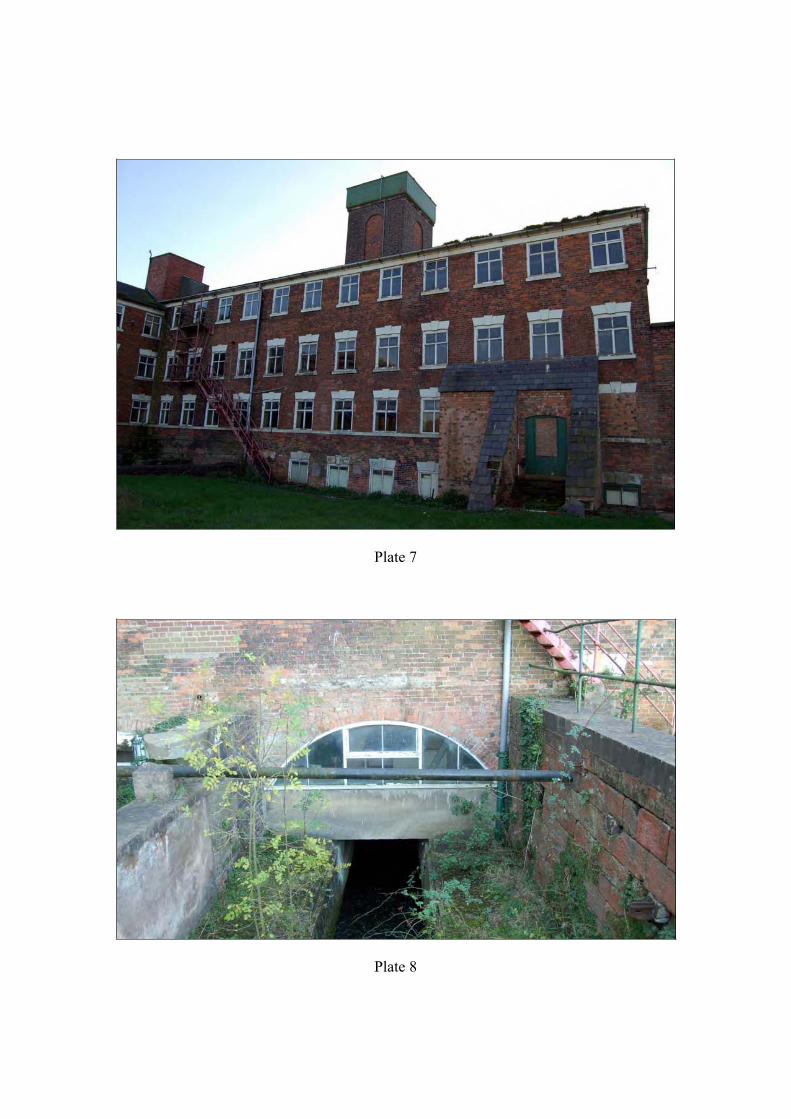
Plate 7
Plate 8
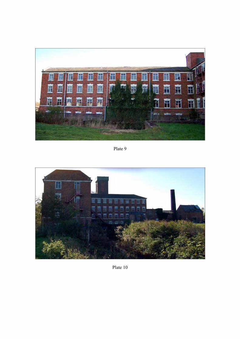
Plate 9
Plate 10
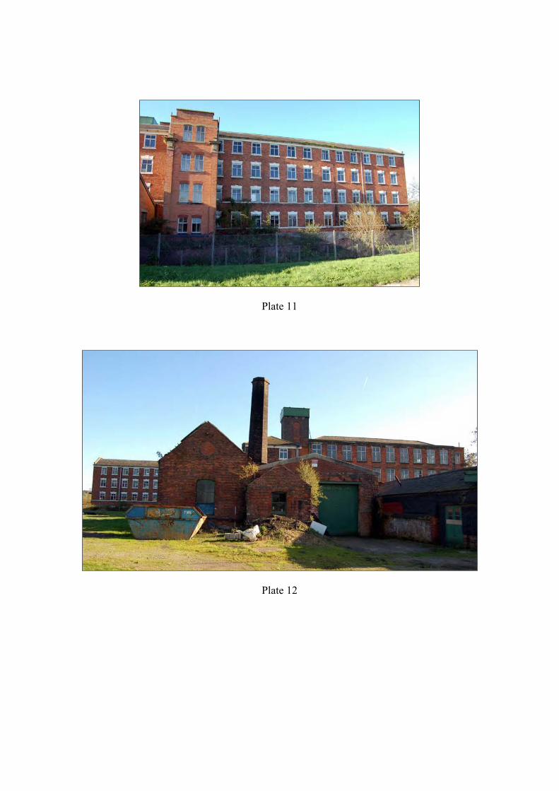
Plate 11
Plate 12
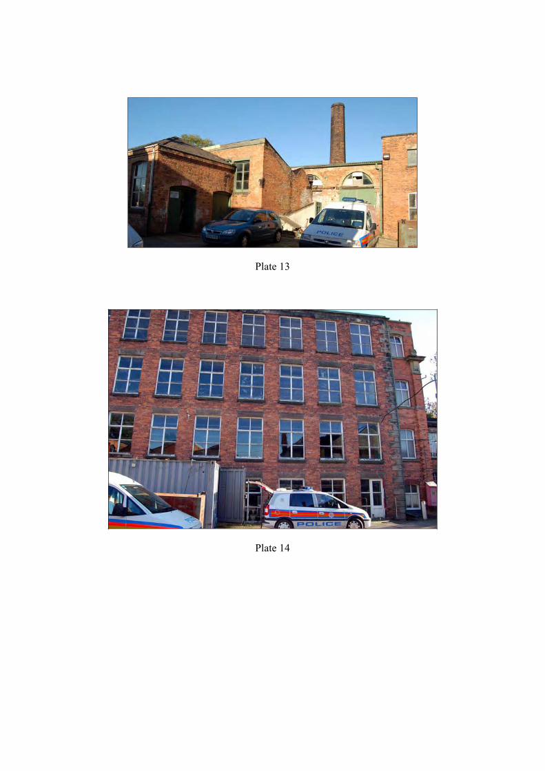
Plate 13
Plate 14
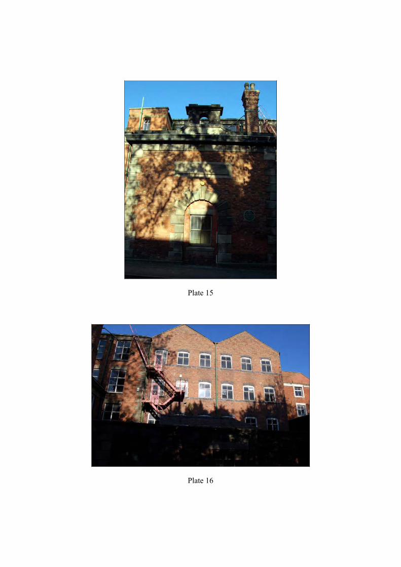
Plate 15
Plate 16
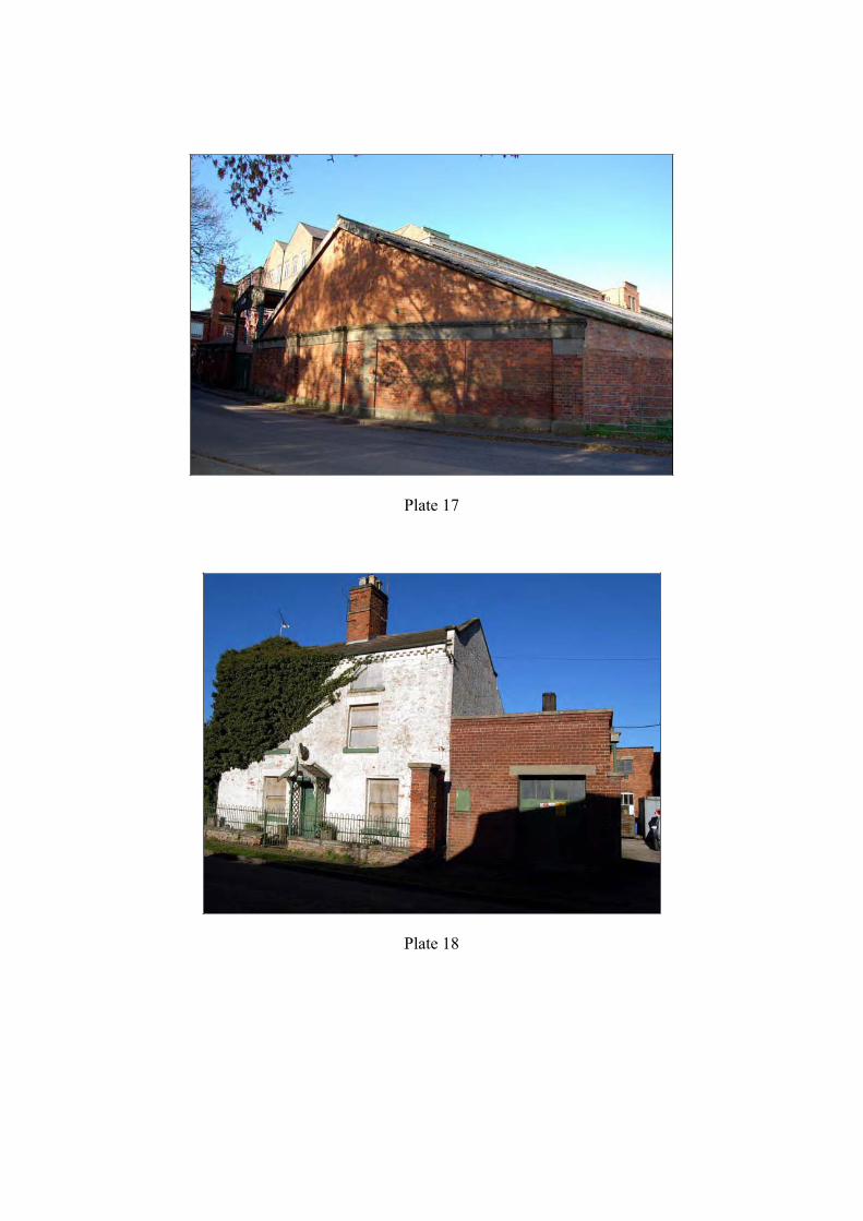
Plate 17
Plate 18
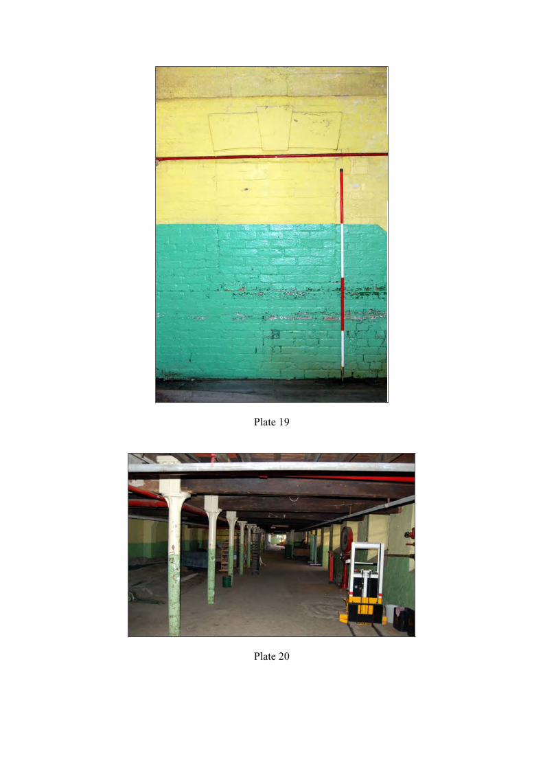
Plate 19
Plate 20


