Embed Size (px)
Citation preview
DRAFT
birminghamarchaeology
IFA
REGISTERED
ORGANISATIO
N
DRDRRARA
DRDD
PN 2083
Westhill Farmhouse,Culworth,
Northamptonshire
Historic Building Recording
June 2010
DRAFT
Westhill Farmhouse, Culworth, Northamptonshire
Historic Building Recording
TABLE OF CONTENTS
Summary ......................................................................................................iii
1 INTRODUCTION ..........................................................................................................................5
1.1 Background to the Project ................................................................................ 51.2 Reasons for Work ........................................................................................... 51.3 Scope of Report.............................................................................................. 51.4 Aims and Objectives........................................................................................ 6
2 SITE LOCATION...........................................................................................................................6
3 STATUTORY DESIGNATIONS .......................................................................................................7
4 METHODOLOGY ...........................................................................................................................7
4.1 Documentary Research.................................................................................... 74.2 Photographic Survey ....................................................................................... 74.3 Visual Analysis ............................................................................................... 84.4 Measured Survey ............................................................................................ 84.5 Grey Literature Report..................................................................................... 8
5 HISTORICAL BACKGROUND.........................................................................................................8
5.1 General History .............................................................................................. 85.2 Westhill Farmhouse......................................................................................... 9
6 HISTORIC BUILDING ANALYSIS................................................................................................11
6.1 Introduction................................................................................................. 116.2 Exterior ....................................................................................................... 116.3 Interior ....................................................................................................... 14
7 CONCLUSION ............................................................................................................................18
7.1 Discussion ................................................................................................... 18
8 ACKNOWLEDGEMENTS ..............................................................................................................20
9 SOURCES...................................................................................................................................21
APPENDIX A: Glossary of Terms ...............................................................................................................23
APPENDIX B: Listed Building Descriptions .................................................................................................26
List of Figures
Figure 1: Site Location. Figure 2: Detailed Site Location Plan. Figure 3: Extract of 1839 Tithe Map. Figure 4: Ordnance Survey County Series 1st Edition 1:2500 map of 1884. Figure 5: Ordnance Survey County Series 1st Revision 1:2500 map of 1900. Figure 6: Ordnance Survey County Series 2nd Revision 1:2500 map of 1922.
DRAFT
Figure 7: Ordnance Survey National Grid Series 1:2500 map of 1979. Figure 8: Historic Photograph of Westhill House, May 1907 (From
www.heritagegateway.org.uk). Figure 9: Ground Floor and Basement Plan. Figure 10: First Floor and Second Floor Plan. Figure 11: East and West Elevations. Figure 12: North and South Elevations. Figure 13: Cross Section A-A. Figure 14: Gable Wall Detail B-B.
List of Plates
Plate 1: Aerial view of Westhill Farmhouse (© Google Earth). Plate 2: Long view of Westhill farmhouse and associated ironstone garden wall. Plate 3: Walled garden to east of farmhouse, D’Anvers House beyond. Plate 4: Westhill Farmhouse, east elevation; early C17th block to right, late C17th
gable to left. Plate 5: Doorway, east elevation. Plate 6: Window, east elevation. Plate 7: Phase break in east elevation. Plate 8: Late C17th gable. Plate 9: Former door in late C17th block. Plate 10: Moulded basement window to late C17th block. Plate 11: Detail of blocked basement window. Plate 12: Lower ironstone masonry of late C17th block. Plate 13: West elevation with late C17th ranges projecting to north and south. Plate 14: Westhill Farmhouse, north elevation; late C17th extension to right. Plate 15: Oblique view of northern extension (windowless pigeon-loft to first floor). Plate 16: Oblique view of southern extension, later structures to right. Plate 17: Blocked openings in north wall of south extension, note squinch to left 1F
level above blocked door. Plate 18: Westhill Farmhouse, south elevation (to High Street). Plate 19: Room [GF06], note bolection fireplace to centre left. Plate 20: Room [GF06], reset small-square panelling to east wall, note stair to right. Plate 21: Room [GF06]; chequer floor of white (Culworth) and black (Byfield) stone. Plate 22: Room [GF04]; partially surviving chequer floor. Plate 23: Obscured (?) panelling / studwork within corridor [GF05]. Plate 24: Room [GF01]; general view looking south-east. Plate 25: Room [GF07]; general view looking south-east. Plate 26: Room [GF07]; general view looking north. Plate 27: Corridor [GF09] looking west. Plate 28: Room [GF10]; general view looking north; note bolection doorcase (compare
Pl. 50). Plate 29: Room [GF10]; general view looking south-east. Plate 30: Room [GF10a]; blocked window. Plate 31: Room [GF10a] looking north. Plate 32: Room [GF10a]; stone floor to south. Plate 33: Room [GF11], general view looking west. Plate 34: Room [GF11], east wall showing recess (former cellar window) and blocked GF
window over (brickwork).
Plate 35: Detail of blocked basement window, reused as cupboard, [GF11]. Plate 36: Room [GF11], upper section of blocked GF window visible above former ceiling
level.
DRAFT
Plate 37: Stair descending to basement [B01]; note blocked window (brickwork, right) and widening of western stone wall (left).
Plate 38: Basement Room [B01]; general view looking east, note blocked window to left.
Plate 39: Basement [B01]; widened west wall abutting south wall adjacent to vent (left).
Plate 40: Drainage channel in west wall of [B01]; note original ironstone masonry of primary wall.
Plate 41: Stair [1F04] GF 1F. Plate 42: Passage [1F02] looking north. Plate 43: Room [1F01] looking east. Plate 44: Small-square panelling and Jacobean overmantle in Room [1F05]. Plate 45: Room [1F05]; detail of Jacobean overmantle. Plate 46: Room [1F05] decorated leaf shutter. Plate 47: Room [1F05]; cocks-head hinge. Plate 48: C18th-fielded panelling within Room [1F06]. Plate 49: C18th-fielded panelling and bolection fireplace in south wall of Room [1F06]. Plate 50: Room [1F07] looking north-east; note bolection doorcase (compare Plate 28). Plate 51: Room [1F07] looking south-west; note cupboard within blocked window of
west wall. Plate 52: Room [1F07] looking north. Plate 53: Room [1F07]; stair head. Plate 54: Stair [1F08]; 2F 1F. Plate 55: Room [2F01] looking west. Plate 56: Stair [2F02] looking south-west. Plate 57: Roof over principal, early 17th-century range (above [1F02/3]). Plate 58: Outbuilding to north-west of farmhouse; looking south-east. Plate 59: Outbuilding to north-west of farmhouse; south elevation. Plate 60: Outbuilding to north-west of farmhouse, west gable. Plate 61: Twisted balusters recorded ex-situ, stored in outbuilding.
List of Tables
Table 1: Parcels of land associated with Westhill Farmhouse in 1839 Tithe Survey.
DRAFT
Westhill Farmhouse, Culworth, Northamptonshire
Historic Building Recording
SUMMARY
Birmingham Archaeology was commissioned by Cluttons, Styles and Whitlock in May 2010 to undertake historic building recording in respect of Westhill Farmhouse, Culworth, Northamptonshire, centred on NGR: SP 54079 47123. The building recording was carried out in order to ensure that any future renovation/conservation work at Westhill Farmhouse is informed by a detailed and accurate understanding of the historic development of the fabric of the structure, as has been requested by the South Northamptonshire Conservation Officer as part of the pre-planning stage of an anticipated future planning application.
The principal aim of the historic building recording was to ascertain, from the readily available documentary and graphic sources and on site visual analysis, the historic development of Westhill Farmhouse. The building was recorded to Level 2 as specified by English Heritage, with a unstable section recorded to a higher level of detail.
The historic building recording revealed a building with an interesting and often illusive general and architectural history and development. The primary phase of Westhill Farmhouse was constructed in the early 17th century. This two-storey phase is of ironstone rubble laid to courses with limestone banding. Internally this phase is characterised by a ground-floor hall with chequerboard stone flooring and small square panelling, whilst first floor level has a highly impressive bedroom with small square panelling complete with strapwork friezing and an integrated wooden fireplace with a notable Jacobean overmantel. The late 17th century saw an extension and an addition added to give the farmhouse a ‘U’ shaped plan, providing further living and utility space in the form of a kitchen, a dairy, a pigeon loft, a cellar, another living room, and an impressive bedroom with fielded panelling and a stone bolection moulded fireplace. Later developments included further extensions to the rear in the 18th and 19th centuries, the construction of outbuildings, and the removal of the original stairs.
18th century and later alterations to the west wall of the late 17th century southern addition have served to make this wall structurally unsound. These alterations saw the blocking up of two late 17th-century basement and ground-floor windows, the insertion of a brick chimney and flue, the creation of a cupboard and curing area through hollowing out of the original wall and by the insertion of another wall from basement level upwards.
Westhill Farmhouse poses a number of questions as to its original status and tenurial history. It is clearly not simply the residence of a typical or well off yeoman farmer. Its orientation, size, decoration, associated buildings and history all point to a loftier if perhaps manorial status, conceivably serving as the home farm of the manor.
DRAFT
Westhill Farmhouse, Culworth, Northamptonshire
Historic Building Recording
1 INTRODUCTION
1.1 Background to the Project
1.1.1 Birmingham Archaeology was commissioned by Cluttons, Styles and Whitlock in May 2010 to undertake historic building recording in respect of Westhill Farmhouse, Culworth, Northamptonshire (centred on NGR: SP 54079 47123; see Figure 1, Plate 1).
1.2 Reasons for Work
1.2.1 The current report has been prepared in order to ensure that any future renovation/conservation work carried out at Westhill Farmhouse is informed by a detailed and accurate understanding of the historic development of the fabric of the structure, as has been requested by the South Northamptonshire Conservation Officer as part of the pre-planning stage of an anticipated future planning application.
1.2.2 The historic building recording was requested in accordance with Policy HE6 of Government Guidance PPS5 (DCLG 2010, 6) which requires that, where a proposed development may have an impact upon a heritage asset, the applicant should provide an assessment of the importance of the heritage asset and of the likely impacts of the proposed development upon that significance.
1.3 Scope of Report
1.3.1 In the absence of a formal brief for the project, the historic building recording has been carried out in accordance with instructions provided by the client following consultations with the Conservation Officer of South Northamptonshire Council. It was requested that Westhill Farmhouse should be recorded to Level 2 as outlined in Understanding Historic Buildings: A guide to good recording practice (English Heritage 2006). In addition, it has also been requested that particular attention is paid to identified sections of the building, which have been deemed to be structurally unsound.
1.3.2 This report outlines the results of the historic building recording, which has been prepared in accordance with the Institute for Archaeologists Standard and Guidance for Archaeological Desk-Based Assessment (IfA, 2008a) and the Institute for Archaeologists Standard and Guidance for the archaeological investigation and recording of standing buildings and structures (IfA, 2008b). This report also conforms to the guidelines pertaining to historic building assessment and recording as outlined in Understanding Historic Buildings: A guide to good recording practice (English Heritage 2006).
1.3.3 This report has been prepared based upon information current and available as of May/June 2010. Details of archaeological terms used in this report are given in the glossary appended as Appendix A.
DRAFT
1.4 Aims and Objectives
1.4.1 The principal aim of the current project was to ascertain and understand, from the readily available documentary and graphic sources and on site visual analysis, the historical development of Westhill Farmhouse.
1.4.2 Specific objectives were to:
Produce a permanent record of Westhill Farmhouse through documentary research, drawn record (plans, elevations and cross sections) written record and photographic archive.
To identify, where possible, phase changes, alterations and adaptations throughout the structure.
To inform the sympathetic conservation and future management of Westhill Farmhouse.
2 SITE LOCATION
2.1.1 Westhill Farmhouse is located on the northwestern side of the historic village of Culworth, in southwest Northamptonshire, close to the border with Oxfordshire, c.10 km northwest of Brackley and c. 10 km northeast of Banbury (Figure 1). Culworth has a hilltop position, and is characterised by linear development along High Street, which runs from northwest to southeast through the village (Figure 2). Interestingly, Culworth stands in the midst of what Wood-Jones, in his Traditional Domestic Architecture in the Banbury Region (1963, 3), describes as an “admixture” area, where its architecture reflects the fact that it has two readily available local building stones namely grey limestone and rusty coloured ironstone, which are often used together in the local historic domestic architecture to a very pleasing affect.
2.1.2 Located on the north side of High Street, Westhill Farmhouse is surrounded by walled gardens to the east and west, with the southeastern return of the farmhouse forming part of the boundary wall to the street (Figure 2, Plates 2 and 3). Immediately to the northeast of the house is a larger, three sided walled garden, which itself is adjacent to a former threshing barn, c. 50m to the northeast of Westhill Farmhouse. This barn was extensively renovated in the late 1980s during conversion for domestic use. Immediately across High Street from Westhill House to the south is D’Anvers House; a mainly early 18th-century house incorporating earlier phases of construction (see Section §.3 below).
2.1.3 Accessed from High Street, via a side road to the west and a pedestrian doorway in the walled garden to the east, Westhill Farmhouse is unusually orientated perpendicular to the high street, on a southwest to northeast axis, with the front elevation facing to the southeast (Figure 3, for ease of description and understanding this report will refer to the northwest facing elevation as the west or rear elevation, and the southeast facing elevation as the east or front elevation etc.). Appended to the northwest corner of the farmhouse is an early 18th-century stone outbuilding. A further brick and stone outbuilding forms part of the boundary wall to the northwest, whilst another small structure forms part of the boundary wall to the southeast of the house.
DRAFT
3 STATUTORY DESIGNATIONS
3.1.1 Westhill Farmhouse is included on the Statutory List of Buildings of Special Architectural or Historic Interest as a Grade II listed building (Appendix B (a), date of listing 04/02/1969). The farmhouse sits at the southern edge of its domestic curtilage, the boundary of which is formed by an ironstone wall which runs along the High Street, returning northwards to both the east and west, effectively dividing the rest of the house from the farmyard and providing walled gardens to both the front and rear of the house. A number of the walls in the vicinity of, and associated with the house and farm, are also Grade II listed (Appendix B (b)), including a three sided, early 18th-century brick walled garden complete with moulded stone gateways and segmental pediments. Also in close proximity to Westhill House is a Grade II listed 16th/17th-century barn c. 35m to the northwest and a Grade II listed granary and stables c. 35m to the southwest (Appendix B (c) and (d)). Immediately across the High Street to the south is D’Anvers House, an early 18th-century Grade II listed house which is said to have been built on older foundations by John D’Anvers (Appendix B (e)).
3.1.2 Westhill House and its associated structures are all located within the Culworth Conservation Area.
3.1.3 A search of Northampton County Council’s Interactive Mapping Service http://www2.northamptonshire.gov.uk/interactivemapping/ shows that Westhill House is located within or in close proximity to two areas designated as Historic Environment Assets: MNN280 Culworth Village which dates back to the late Saxon period, and MNN14764 Welsh Road (possibly Margary Route 166), an ancient drove road or road route possibly dating to the Roman period.
4 METHODOLOGY
4.1 Documentary Research
4.1.1 A preliminary search was made of all relevant and readily available published and unpublished documentary source material, including historic maps, early photographs and drawings, written descriptions, and primary and secondary sources related to Westhill Farmhouse held by the Northamptonshire County Record Office (NCRO), the Northamptonshire Library family and local history collections, and more general reference materials held by the libraries of the University of Birmingham. A full list of sources consulted in the preparation of the present report is included below in Section §. 9.
4.2 Photographic Survey
4.2.1 A photographic survey, comprising both general and detail shots of the exterior and interior of the building, was carried out using a high resolution digital SLR camera (Nikon D50). These were further supplemented by capturing selected general and detail shots using a 35mm SLR camera to produce black and white photographs. All general and detail shots included a photographic scale where possible. All photographs were recorded on a pro forma record sheet detailing subject, direction, photographer and date.
DRAFT
4.3 Visual Analysis
4.3.1 A written description of the building was compiled in the field on pro forma building and room record sheets noting details such as function, date(s), materials, plans, elevations and phasing. In addition, pre-existing survey drawings provided by the client were checked and annotated on site.
4.4 Measured Survey
4.4.1 A measured survey, resulting in the preparation of floor plans and elevations, was carried out by Cluttons, Styles & Whitlock prior to the commencement of archaeological building recording. The results of this survey were supplied to Birmingham Archaeology, and were checked and annotated on-site during the recording.
4.4.2 In addition, it was decided during the fieldwork that further cross sections through the building would prove useful as illustrative aids. These were surveyed using a combination of hand survey using a Leica Disto electronic distance measuring device.
4.5 Grey Literature Report
4.5.1 The information gained using the methods outlined above has been compiled into this accessible grey literature report.
5 HISTORICAL BACKGROUND
5.1 General History
5.1.1 Unlike many of the nearby towns and villages such as Sulgrave, Banbury, or Thorpe Mandeville, there does not seem to have been a synthesis of the village of Culworth’s history.1 Culworth is perhaps most famous or infamous for its associations with the notorious Culworth Gang, a group of local highwaymen and criminals, who terrorised the people of the surrounding area for nearly ten years in the late 18th century, before they were captured in 1787. It was this association which gave Culworth an unwanted but probably merited reputation at the time as being a “den of thieves, rustlers and highwaymen” (Evening Telegraph, 15.03.1975). However, Culworth’s history stretches much further back, with the local parish website (www.culworth.net) noting that “Iron Age settlers were some of the first to recognise Culworth as a good defensive position”, whilst a 3rd-century Roman coin was uncovered in Culworth in 1841 (RCHME 1982, 39). In addition, an ancient routeway, known as the Welsh Way, linking Welsh drovers to markets in Northampton, Leighton Buzzard and London, runs through Culworth.
5.1.2 Culworth is mentioned in the Doomsday Book as Culeorde, whilst other early records give it as Coleworth or Culleworth (Baker 1790, 604), all of which appear to refer to the name of the first proprietor, in combination with the Saxon worth,denoting estate or residence or “Cula’s Enclosure”, Cula being an Old English personal name (Watts 2004, 175), suggesting some sort of settlement prior to the Norman Conquest.
1 Sources at Northamptonshire Library suggest that a Gillian Swingler was compiling a history of Culworth in the 1970s, however this does not appear to have been published.
DRAFT
5.1.3 The modern day village of Culworth appears to occupy two medieval settlements, Culworth and Brime, the latter of which was long thought to have been lost but is now believed to have occupied the southeastern area of the village which includes the Church and the ringwork castle now known as Berry Hill (RCHME 1982, 39). In addition to this, it is now believed that the medieval extent of the settlement of Culworth was much larger than it first appears, as a great deal of settlement activity is implied by quantities of medieval pottery recovered from the area to the south side of the main street, now occupied by allotment gardens. A weekly market was granted in 1264 (Kelly’s Directory 1890) with the main crops in the area being wheat, barley, and beans; however, the greater proportion of the land was given over to pasture.
5.1.4 In 1612, 2000 acres of land were enclosed at Culworth, with 1200 of these acres belonging to Miss Richards of Sunninghill, Berkshire. Baker (1790, 605 although probably compiled earlier) notes that the manor is said to have been purchased in 1638-9 by Robert Danvers Esq. and also reports that the Manor House, “situated near the centre of the village, though long the residence of the Danvers family… is now in a very dilapidated state, and occupied by poor families”. Incidentally, it would appear that the Danvers family relocated the manor house to Danvers House, immediately opposite Westhill Farmhouse.
5.1.5 Culworth, like much of the surrounding region appears to have had its heyday, at least architecturally speaking, in the late 16th and 17th centuries. Prosperity brought about by the sheep/textile trade saw the rise of the yeoman farmer who “sought to consolidate his new wealth and position by building a new home” (Wood-Jones 1963, 11). This is reflected in the village’s built heritage, where many of the extant buildings, such as Westhill Farmhouse, were constructed during this period.
5.2 Westhill Farmhouse
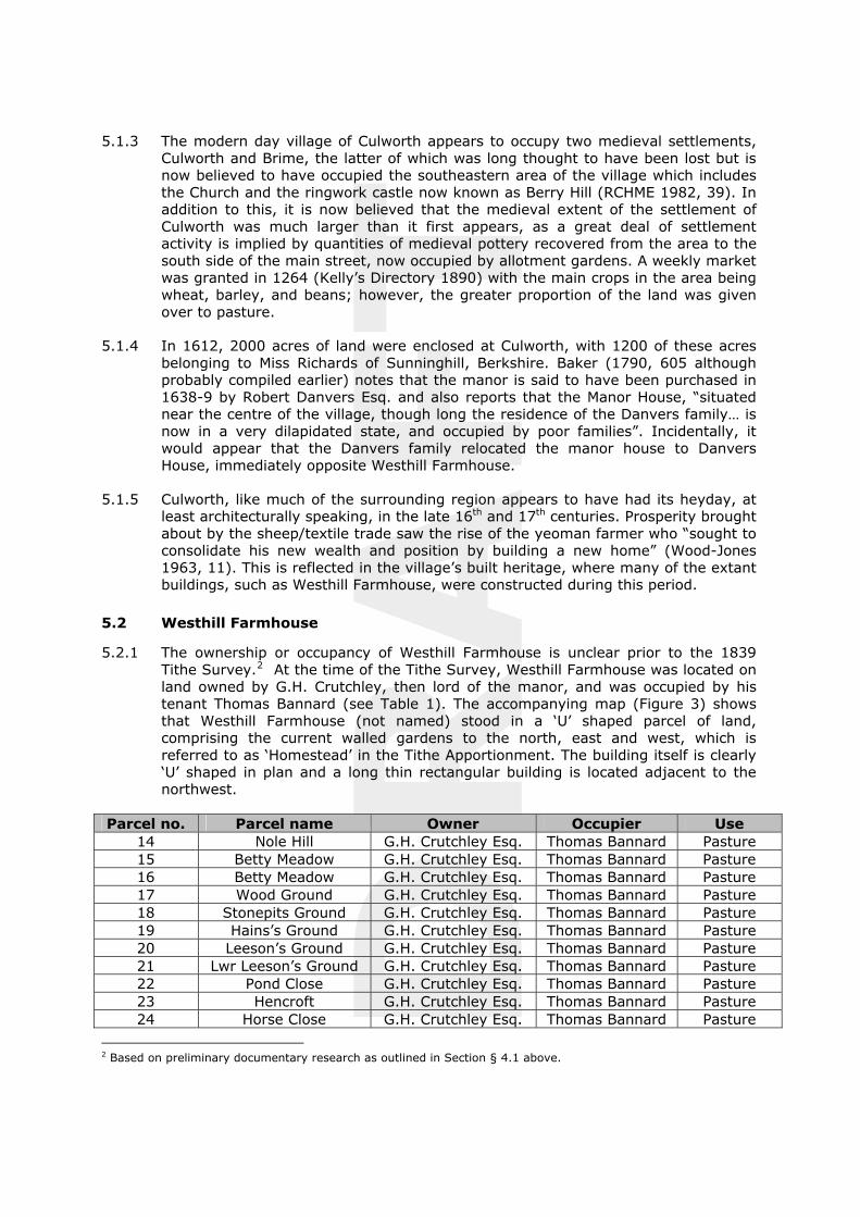
5.2.1 The ownership or occupancy of Westhill Farmhouse is unclear prior to the 1839 Tithe Survey.2 At the time of the Tithe Survey, Westhill Farmhouse was located on land owned by G.H. Crutchley, then lord of the manor, and was occupied by his tenant Thomas Bannard (see Table 1). The accompanying map (Figure 3) shows that Westhill Farmhouse (not named) stood in a ‘U’ shaped parcel of land, comprising the current walled gardens to the north, east and west, which is referred to as ‘Homestead’ in the Tithe Apportionment. The building itself is clearly ‘U’ shaped in plan and a long thin rectangular building is located adjacent to the northwest.
Parcel no. Parcel name Owner Occupier Use14 Nole Hill G.H. Crutchley Esq. Thomas Bannard Pasture15 Betty Meadow G.H. Crutchley Esq. Thomas Bannard Pasture16 Betty Meadow G.H. Crutchley Esq. Thomas Bannard Pasture17 Wood Ground G.H. Crutchley Esq. Thomas Bannard Pasture18 Stonepits Ground G.H. Crutchley Esq. Thomas Bannard Pasture19 Hains’s Ground G.H. Crutchley Esq. Thomas Bannard Pasture20 Leeson’s Ground G.H. Crutchley Esq. Thomas Bannard Pasture21 Lwr Leeson’s Ground G.H. Crutchley Esq. Thomas Bannard Pasture22 Pond Close G.H. Crutchley Esq. Thomas Bannard Pasture23 Hencroft G.H. Crutchley Esq. Thomas Bannard Pasture24 Horse Close G.H. Crutchley Esq. Thomas Bannard Pasture
2 Based on preliminary documentary research as outlined in Section § 4.1 above.
DRAFT
25 Homestead G.H. Crutchley Esq. Thomas Bannard Homestead
Table 1: Parcels of land associated with Westhill Farmhouse in 1839 Tithe Survey
5.2.2 The 1841 Census Return records that Thomas Bannard was a 35 year old farmer who lived with his wife Susanna (also 35), his daughters Mary (13) and Susanna (2), and sons John (11) and Thomas (5). The 1851 Census provides a further insight into the Bannard family. It notes that Thomas Bannard was a farmer employing 14 labourers, that they had had another daughter, Ann (9), and that they had a live-in servant named Elizabeth Mattey. Thomas Bannard also features in the 1854 editions of Kelly’s Directory and the Post Office Directory, which list him as a farmer and grazier, whilst Kelly’s Directory 1890 also lists George Henry Crutchley, as Lord of the Manor. The next Census in 1861 lists Thomas Bannard as being a farmer with 300 acres, employing 8 men and 4 boys. This acreage had increased to 385 acres by 1871, where the census notes that the now 66 year old Thomas Bannard employed 7 men and 4 boys and was living with his daughters Mary (42), Susanna (32) and Ann (29) along with granddaughter Eleanor (4), and a female servant.
5.2.3 There is no listing of Thomas Bannard or any member of his family in the 1881 Census. It is unclear as to who was in residency at West Hill Farmhouse at this time as house names or numbers were not listed on the census return. As Thomas Bannard was not mentioned in the 1876 edition of the Harrod & Co. Directory one can assume that the Bannard’s had vacated Westhill Farmhouse at some point in the previous five years, presumably following the death of Thomas himself who was at that time in his late 60s.
5.2.4 By the time of the 1884 1st Edition Ordnance Survey 1:2500 map (Figure 4) it is clear that there had been a number of additions/extensions to Westhill Farmhouse. The southern arm of the ‘U’ shaped plan had been extended westwards with three distinct additions, each rectangular in plan. Also, there had been two additions to the north east facing return, and a number of cellular structures to the northwest (presumably pigsties or small pens). The walled garden to the north appears to have been formally planted, having geometrically laid out pathways and rows of trees.
5.2.5 Neither the 1890 edition of Kelly’s Directory or the 1891 Census Return provide an insight into who occupied Westhill Farmhouse at that time, whilst the 1900 1st
Edition Revision Ordnance Survey 1:2500 map (Figure 5) shows little alteration to the house or its grounds.
5.2.6 The first readily available documentary evidence for a new occupier at Westhill Farmhouse is found in the 1910 edition of Kelly’s Directory where Arthur Edwin Cooke, farmer, is listed as proprietor of Westhill Farm. Arthur Edwin Cooke is still listed as proprietor in the 1920 edition, and by the time of the 1922 2nd Revision Ordnance Survey 1:2500 map (Figure 6) very little had changed as regards the plan of the building or its surroundings since the previous edition.
5.2.7 Arthur Edwin Cooke continues to be listed as proprietor in the 1940 edition of Kelly’s Directory, whilst the 1979 Ordnance Survey National Grid Series 1:2500 map shows that one of the additions to the northeast had been removed, and that the cellular buildings to the northwest had been cleared away.
DRAFT
6 HISTORIC BUILDING ANALYSIS
6.1 Introduction
6.1.1 Westhill Farmhouse (Figure 8) was built in the early 17th century at a time when the Northamptonshire’s yeoman farmers were consolidating their newly acquired wealth into constructing new homes. It is unclear what the site’s use was prior to the construction of the farmhouse, however, it seems likely that it was built on a virgin site (probably farmland), and on what appears to have been manorial land.3
This primary phase building was set back from the main road and had two storeys with two large rooms at ground-floor and first-floor levels (Figures 9 and 10). It is of coursed ironstone rubble banded with limestone. This phase of construction is characterised in the interior by a ground-floor hall with small square panelling and a chequerboard pattern stone floor, and by a panelled upstairs bedroom with an impressive fireplace complete with Jacobean overmantel. The opposed entrances of the primary phase reflect a 16th and 17th-century fashion, which maintained a tradition from the earlier medieval hall, where the opposed entrances were located to the rear of the screens passage.
6.1.2 The next phase of construction was in the late 17th century where a southern wing and a northern extension provided the building with a ‘U’ shaped plan. Both of these were principally constructed in limestone, with ironstone rubble to plinth level. These served to provide increased living space, a kitchen, a dairy, a pigeon loft, and a bedroom with adjoining dressing room at first-floor level. It would appear that the ironstone rubble plinth is original to this late 17th-century addition rather than being part of an extended primary phase, which was later remodelled, which could be construed from the fabric. Supporting this is the fact that it is unlikely that an early 16th-century farmhouse would have had a cellar, which was more of a late 17th/early 18th century introduction in the region (Wood-Jones 1963, 95), and secondly it appears to be popular in the village to have an ironstone plinth level with limestone walling above. This may have been a stylistic preference or it may have been a functional consideration as ironstone is much less porous than the permeable limestone, and therefore much more suitable for use at plinth level.
6.1.3 The 18th century saw further alterations and additions, with fielded panelling added to the recently created bedroom; the addition of a squinch to improve first floor access and circulation following the recent alterations; the insertion of a staircase, the construction of a single-storey stone addition to the rear of the southern wing; and the alteration of the rear wall of this wing to provide a curing space behind a fireplace. This remodelling saw the latter wall being partially truncated and another wall constructed from basement level upwards, necessitating the blocking of a mullioned basement window. A further single-storey addition was added to the west of this in the mid/late 19th century.
6.1.4 The original stone slate roof has been completely renewd in plain tiles within recent memory (Vernon Phipps pers. comm.)
6.2 Exterior
6.2.1 The principal front or east elevation (Figure 11a, Plates 4 to 12) consists of an early 17th-century three-bay, two-storey section, which is abutted to the south by a two-
3 This assumption is based on the fact that Westhill Farmhouse occupies land owned by the lord of the manor in the 19th century.
DRAFT
bay, two-storey-with attic addition of late 17th-century date. The early 17th-century section is of coursed ironstone rubble banded with limestone with the doorway located at the second bay from the south. This doorway has a stone voussoired head, partially obscured by a 19th-century timber lattice work porch (Plate 5). The 6-panel door is unlikely to be original to the structure. Ground-floor level is pierced by two iron casements and a late 19th/ early 20th-century inserted timber casement window to the north of the doorway. The rectangular leaded iron casements, two-light to the south and four-light to the north of the doorway, have splayed stone sills, timber lintel heads, and iron fittings such as spiral stays, hinges, and turnbuckle catches (Plate 6) which are likely to be of a mid/late 17th or 18th century date. A pier of brickwork between the southern window and the doorway suggests some rebuilding. First-floor level has a central two-light casement window with timber lintel, which is flanked by two, two-light iron casements on either side. These, apart from having cut limestone jambs, are similar in detail to those on ground-floor level. The pitched roof slightly oversails this elevation and its rafters are exposed at the eaves. The northern angle, where this elevation meets the northern return has alternating stone quoins, whilst there is a clear building break to the south where it abuts the late 17th-century extension (Plate 7). Both return ends of this section are marked by stone chimneys with dressed stone copings.
6.2.2 The late 17th-century addition to the south is of two storeys with attic (Plate 8), rising to a gable from shaped stone kneelers and has coped verges, constructed predominantly of grey limestone rubble laid to courses. Plinth level, however, is of ironstone (Plate 12) and contains two blocked basement windows (Plates 9 and 10), one of which retains its plain chamfered surround and mullion (Plate 11). Ground-floor level is pierced by two two-light wooden casements, the northernmost of which has three-piece stone lintel head with keystone and an iron window stay, with its sill being formed by the head of the basement window (Plate 10). The other ground floor window (Plate 9) appears to have been altered. This is likely to have been originally similar in detail to its neighbour; however it seems to have been lengthened to create a doorway. The insertion of this doorway saw the basement window below removed and the original keystone window head replaced with a segmental arch dressed ironstone head. The window was later reinstated and the lower section of the doorway infilled. First-floor level has two windows which are similar to the northern window on ground-floor level, whilst attic level is pierced by a single central window with a similar style head. The apex of the gable is formed by a red and blue brick chimney.
6.2.3 The original early 17th-century rear/west elevation (Figure 11b, Plates 13 to 17) has been partially obscured by a late 17th-century extension to the north, whilst the gable ended addition, seen to the south of the front elevation projects westwards giving the building a ‘U’-shaped plan. The unobscured section of the original elevation is almost completely of ironstone rubble laid to courses, with occasional random limestone blocks and banding. The central doorway at ground-floor level is directly opposite that on the east elevation and is similar in detail, complete with timber lattice work porch and 6-panelled door. This doorway, which has alternating limestone quoins, is flanked to the north by a blocked opening under a timber lintel. There is no evidence of an opening on the southern side of the door. First-floor level is pierced by two windows with timber lintels, the southernmost of which has been blocked, whilst the other houses a two-light iron casement similar in detail to those on the east elevation. At first-floor level, in the angle between this elevation and the northern return of the south addition, is an 18th-century red brick squinch laid to Flemish Bond and carried on projecting timbers. This squinch, which was introduced to improve internal circulation following later additions, is lit by a
DRAFT
two-light iron casement, rectangular leaded window with timber lintel, and surviving iron fitments such as a turnbuckle catch and a quadrant stay.
6.2.4 The two storey northern addition (Plate 15), which clearly abuts the central, early 17th-century part of the house, has a plinth course of ironstone rubble laid to courses, with the remainder of the wall being limestone rubble laid to courses. The west facing elevation of this addition rises to a gable which springs from stone kneelers. This elevation, which appears to have originally been blind, has had a doorway inserted to the south of centre at ground-floor level. The lower section of the door has been infilled with ironstone to create a window, which has had a two-light frame inserted under a timber lintel. The southern return of this addition is also blind; however there is evidence for a blocked doorway and a former window at ground-floor level. It is unclear as to whether these were original to the addition or were inserted at a later date. The northern return (Figure 12b; Plate 14), which clearly abuts the original farmhouse structure, is pierced by a central opening at ground-floor and first-floor levels. The wide three-light fixed timber window at ground-floor level is interesting in that it has a dressed stone surround and evidence for two former ovolo mullions. A doorway at first-floor level, which provides access to the pigeon loft, has a plank and batten doorway with iron strap hinges with spearhead shaped ends and an iron hook latch. Scarring and straight joints in the stonework above the timber lintel of this door suggest that this door may have been truncated, or that there may originally have been a window above. An early 18th-century gabled stone outbuilding4 is appended to northwest corner.
6.2.5 The southern, late 17th-century addition to the south (Plate 16) is of two-storeys with attic and is of limestone construction. It is completely obscured at ground-floor level by a 19th-century single-storey gabled red brick addition to the north and a single-storey 18th-century gabled stone addition to the south. First-floor level is pierced north of centre by a single, two-light leaded timber casement window with saddle bar and keystone head similar to those on the east elevation. The two-light window at attic level has a stone lintel head. The gable, as in the east elevation, rises from stone kneelers and the apex is formed by a red and blue brick chimney. The north return of this addition (Figure 13; Plate 17)has a blocked doorway with stone surround at ground-floor level. This has been infilled with red brick and two four-pane lights. First-floor level supports the squinch, and has a blocked window with a keystone lintelled head. Eaves level is of ironstone rubble laid to courses. The 19th-century addition has a pitched gabled red plain tile covered roof, and is of red brick laid to English Garden Wall bond, with a central doorway flanked by a two light and a three light window on either side (Plate 16). The 18th-century addition has a pitched gabled red plain tile roof and is of ironstone and limestone rubble laid to courses, with a single multi-pane window high up on the west facing wall. A red brick lean-to toilet block to the west of this was probably added in the late 19th
century or early 20th century.
6.2.6 The early 18th-century street elevation (Figure 12a, Plate 18) has an ironstone plinth up to sill level and is clearly abutted by the 18th-century addition to the west and the boundary wall to the east. The majority of the walling is of coursed limestone with alternating quoins. It would seem that ground-floor level was originally blind, with a window added later when necessitated by the addition of the structure to the west which served to block any natural light entering this level of the building. This inserted window has a timber lintel and sill and contains a 20th-century replacement sash window. First-floor level originally had two windows; the
4 Historically used as a washhouse (Vernon Phipps pers comm.).
DRAFT
eastern window has been blocked although it retains its keystone lintel; the other opening houses a two-light casement with a timber mullion and transom.
6.3 Interior
Ground Floor (Figures 9, 13 and 14)
6.3.1 The interior is accessed through opposing doorways from the east (front) and west (rear). These open to the original hall GF06 (Plates 19 to 21) which retains its original stone paved floor laid in the carreaux d’octagones pattern in white Culworth and black Byfield stones (Plate 21). Each of the walls is furnished with early 17th-century small square panelling; this panelling is almost completely devoid of decoration apart from a small section of curvilinear strapwork friezing on the east wall (see Figure 9). The panelling does not appear consistent in places, particularly on the north wall (Plate 20), which contains a doorway with L-hinges, and cupboards with H-hinges, suggesting that it has been reset or rearranged. The room is lit by a single two-light iron casement window in the east wall with splayed embrasure and iron fitments. The south wall has a late 17th-century fireplace with bolection moulded stone surround (Plate 19). Round arch headed doorways provide access to GF05 to the north and GF08 (inserted) to the south. First-floor level is accessed via an inserted quarter-turn stairwell of 18th/19th-century date with a quarterspace landing and an elegant initial flight of steps rising from the hall, the latter with tapered, turned newel post, stick balusters, and flat-topped handrail. It is unclear, however, from the visible fabric how first-floor level was originally accessed. It is probable that the late 17th-century remodelling, which saw additions to the side and rear, necessitated the removal of the original stairs.5
6.3.2 The continuation of the original hall’s chequerboard-style stone flooring into corridors GF03 and GF05 and the under-stairs area and storage room GF04 (Plate 22) suggests that the original hall may have been larger and may help explain the rearranged panelling on the north wall. This may also explain the panelling/studwork evident in the south wall of GF05 (Plate 23), a corridor, which is lit by an inserted late 19th/early 20th- century wooden casement window, and provides access to the original parlour GF01 to the north and to the under-stairs area and storage room GF04. GF04 is interesting as it contains the truncated remains of some steps, a turned newel post and stick balusters, suggesting that rather than being ‘L’ shaped, the inserted stairs was originally ‘T’ shaped, with access from both the north and south. GF01, the original parlour (Plate 24), has a mid-20th-century stone fireplace, high moulded skirting boards, moulded picture rails, a moulded doorframe with plain chamfered stops and a relatively plain two panelled door. The room is lit by a four-light iron casement with iron fitments and a large-panelled splayed embrasure and dado. The floor is of carpet-covered floorboards.
6.3.3 Corridor GF03 provides access to GF02 (not illustrated), a room added during the late 17th-century remodelling. This room is accessed through a four panelled door down four stone steps. It is unclear what the original function of the room was, however the proliferation of hooks on the wall and ceiling and the stone flag floor suggests it had a utilitarian function, probably a dairy. The room is lit by large wooden three-light fixed window to the north (see Section §.6.24 above for
5 Interestingly, a number of twisted balusters (Plate 61) which could conceivably be from the original stairs were observed in one of the outbuildings during the field survey. It may be an interesting and rewarding venture to carry out a fabric search within these outbuildings and the attic in order to see if any other original features are surviving on site.
DRAFT
description of truncated ovolo mullions), and by a two-light window inserted in a former doorway to the east. A further two-light window, occupying another blocked doorway in the south wall, is blocked from the exterior.
6.3.4 The southern, late 17th-century addition is accessed via the hall GF06 through an inserted doorway in the south wall. This leads to a small lobby GF08 which provides access to each of the ground floor rooms within the extension. GF08 has a stone flag floor and is lit by an inserted internal window above the doorway to GF07; the kitchen. This kitchen (Plates 25 and 26) also has a stone flag floor and is characterised by its attractive bolection panelling with in-built cupboards, and bolection cornicing. The north wall has a recess currently occupied by an AGA range (Plate 26), which is likely to originally have contained a fireplace. A doorway to GF10 has been blocked, and a ladder-type bacon rack hangs from the ceiling. The room is lit by two casement windows in the east wall, with iron fitments and panelled embrasures. Interestingly, a moulded dado rail is exposed behind some of the modern kitchen units, and moulded panelling is visible on the back walls of the in-built cupboards on the west wall.
6.3.5 GF09 (Plate 27) is a corridor providing access to the basement trapdoor, the rear yard (through a now partially blocked doorway), and to a 19th-century addition containing room GF11. It accessed from GF08 through a plank and batten door with iron strap hinges with spearhead shaped ends, and its plank floor doubles as the trapdoor to the basement.
6.3.6 GF10 (Plates 28 and 29) is a living room accessed through a doorway from GF08 through a substantial moulded doorframe and four panelled door. This room has a high but relatively plain moulded skirting board, and moulded picture rail, and is lit by an inserted sash window in the south wall. The west wall has a west of centre fireplace with a 20th-century faux marble surround. This wall is slightly angled on its south side, where a doorway with a four panelled door provides access to GF10a, a cupboard and a meat curing area. GF10a (Plates 30 to 32) is divided into two sections by a two panelled door with L-hinges. The southern section has a stone flag floor and there is a blocked window in the west wall (Plate 30). The northern section appears to be a curing room, taking advantage of the ideal conditions behind the fireplace. The stone flag floor continues to the point where a brick chimney flue projects from the north wall. Each of the walls at this point has been faced with red brick laid on edge in stretcher bond. A number of hooks and chains projecting from the wall and ceiling provide evidence of its former function. It is clear from the recently inserted steel props (Plate 31) supporting the roof at this point that the ceiling has become quite unstable.
6.3.7 The 19th-century red brick extension to the rear containing room GF11 (Plate 33 to 36) has a red brick paviour floor, and is accessed down brick and stone steps from GF09 through an inserted doorway with a plank and batten door which has iron strap hinges with spearhead shaped ends and an iron latch. This room is lit by two windows on the north wall. The south wall includes two alcoves/cupboards with moulded wooden surround and doorways providing access to the exterior and to room GF12 to the south . The lath and plaster ceiling has been partially removed revealing the simple roof structure. The limestone rubble constructed east wall was originally the west-facing exterior wall of the late 17th-century south addition and, despite much alteration, it retains many of its original features (Plate 34). A moulded stone recess at room level (Plate 35) is, on closer inspection, the remains of the former basement window similar to that recorded in the east elevation (Plate 11). The southern light has been blocked with brickwork, whilst the other side has
DRAFT
had been converted and a shelf inserted. Above this, at ceiling level, is a blocked window, complete with keystone and lintel head (Plate 36) similar to those higher up in the elevation. This window originally provided light to room GF10, and the presence of this original window at this level suggests that the curing room, fireplace, and cupboard in GF10a are part of a later remodelling of this part of the house, which saw the original west exterior wall partially hollowed out, the window blocked, and another wall added to accommodate the fireplace and curing room behind.
6.3.8 Room GF126 is a small room in an 18th-century stone addition. It is accessed up brick lined steps from GF10. The room has a blocked window in the east wall, a brick paviour floor, a lath and plaster ceiling, and is lit by a small window with a splayed embrasure high up on the west wall. The blocked window is likely to have formerly been a basement window similar to that on the north side of this elevation and on the east elevation of the house. It would seem that the stone mullion surround was removed, the window heightened, and subsequently blocked up.
Basement (Figure 9b)
6.3.9 The basement (Plates 37 to 40) is located underneath the late 17th-century southern extension, beneath rooms GF07, GF08, GF09 and GF10. It is accessed through a trap door in GF09, down a quarter-turn stone stairs with winder. This stairwell provides a fascinating insight into the alterations outlined above, carried out when room GF10a was formed. A bricked up opening on the west wall (Plate 37) appears to be the remains of the rear side of the mullioned basement window seen in GF11. This would originally have provided light to the basement staircase but was blocked up as part of the later alterations. A straight/butt joint in the south wall (Plate 37) illustrates the widening of the west wall to create the space GF10a above. Despite a thick layer of mud, the basement appears to have a stone flag floor. The floor above is carried on east-west running joists which are fixed to three substantial north-south running beams which are supported by two central brick piers with rounded corners and three engaged piers in the east wall. Other notable features in the basement area include evidence of the former basement windows in the east wall (Plate 38), an inserted brick buttress supporting the south wall, and an air vent in the west corner of the south wall. Also noted were a segmental arch headed opening which pierces a brick partition in the northwest corner, and a drainage channel in the west wall which exposes the original ironstone masonry of the primary wall Plate 40). Butt joints in the southwest and northwest corners provides further evidence that the west wall has been inserted (Plate 39).
First Floor (Figures 10, 13 and 14)
6.3.10 The upper storeys are accessed via the stairs 1F04 (Plate 41) which rises from the original hall GF06. This quarter-turn stairs, which has quite clearly been inserted, has evidence for timber studwork in its south wall. It rises to the passage 1F02(Plate 42) which provides access to rooms 1F01, 1F03, 1F05, 1F06 and 1F10. This is lit by a two-light iron casement window complete with iron fitments identical to those found in the other windows in this original part of the house. A further window to the south has been blocked and now serves as a cupboard. A hatch at the north end of this passage provides access to the roof space above.
6 Largely inaccessible at the time of survey due to health and safety concerns.
DRAFT
6.3.11 Bedroom 1F01 (Plate 43) has wide east-west running floorboards and is accessed through a doorway with moulded surround and a two panel door. It is lit by a four-light iron casement in the east wall with splayed embrasure and iron fitments similar to those in 1F04. A fireplace in the north wall has been boxed over in recent times.
6.3.12 Room 1F03 is a bathroom which presumably was created when the stairs 1F04 were added. It is lit by a two-light wooden casement window, which is likely to have been inserted as part of the same remodelling. A counterpart to the north has been blocked.
6.3.13 Each of the walls in bedroom 1F05 (Plates 44 to 47) is lined with early 17th-century small-square panelling, complete with a carved lunette decorated frieze throughout (Plate 44). The room is characterised by its fireplace on the south wall with its ornate wooden surround which displays strapwork detailing, carved stylized rope moulding mantelshelf and an elaborate Jacobean overmantel (Plate 45), the latter comprising two arches enclosing carved vase and floriated motifs, flanked by paired Doric columns on either side. The room is accessed from the passage 1F02 through an eight-panelled door complete with cocks-head hinges (Plate 47) and metal lock case. The room is lit by a four-light iron casement window with iron fitments similar to those in 1F01. The splayed embrasure is covered with decorated leaf shutter/panelling (Plate 46), whilst the panelling on the jambs is decorated with intricate guilloche carving, and foliated lozenges at dado level.
6.3.14 Bedroom 1F06 (Plates 48 and 49) is also completely panelled. However, the panelling in this room is of large fielded panels, characteristic of the 18th century. The room is accessed from 1F02 through a three-panelled door with moulded surround and L-hinges, and has wide floorboards running north-south. There is a similar doorway in the west wall providing access to 1F07; another doorway in this wall is a casement door. This room is lit by two timber casement windows with panelled embrasures and fitted drawers underneath. The south wall has a stone bolection moulded fireplace (Plate 49)7 similar to that in GF06. A panelled door to the west of this provides access to a storage cupboard, which obscures a blocked window, suggesting that the panelling is not original to the room, as this would surely have respected the window, and is consistent with this addition being built in the late 17th century.
6.3.15 Room 1F07 (Plates 50 to 53) was originally only accessed through two doorways from bedroom 1F06, suggesting that its original function was as a dressing room. It seems that it later was converted for use as an additional bedroom, requiring independent access from passage 1F02, hence the construction of the squinch 1F10, which also provided access to the attic storey above. Both doorways from 1F06 have substantial door surrounds similar to those in GF10, whilst the doorway with two panelled door to 1F10 has clearly been inserted. The room is lit by a timber casement cross window in the south wall, and by a two-light wooden casement with stanchion and saddle bars in the west wall. The west wall also has a blocked window and a 19th-century cast iron fireplace. A plank and batten doorway in the north wall provides access to the stair head beneath the inserted stairs which provide access to the attic level rooms. The insertion of this stairs necessitated the blocking of a window, evidence of which is still present in the stair head and in the north wall of the stairwell.
7 This is in very poor condition and is currently being propped up with two planks of wood.
DRAFT
6.3.16 1F09 is a brick lined pigeon loft, which was inaccessible during the survey.
Attic/Second-Floor Level (Figures 10, 13 and 14)
6.3.17 The attic level of the late 17th-century south addition was not originally utilised as domestic space. It is accessed via a quarter-turn staircase with winder (1F08 :Plate 54) from 1F10. It has been divided into two rooms, both of which have thin floorboards and each being lit by single windows within the gable walls. 2F01(Plate 55) has a sloping plaster covered ceiling, with a single chamfered rafter exposed on the north side, whilst SF02 (Plate 56) has been lined with tongue and groove pine cladding.
Roof Level
6.3.18 Roof level of the original early 17th-century structure is accessed through a hatch in corridor 1F02. Partitioning within the roof space meant that it was not possible to see or access all of this area. A single truss (Plate 57) was visible at the northern end of the range, with principals supporting two tiers of through purlins with longitudinal windbracing. Paired queen struts extend between tie and collar, and raking struts above collar level support the upper tier of purlins. The lower section of the truss below collar level is closed by horizontal planking, the collar being truncated to the east to form a doorway to the most northerly bay. It is clear from upvc membrane that the roof has been re-covered in recent times.
Outbuilding
6.3.19 An early 18th-century gabled stone outbuilding appends Westhill Farmhouse to the northwest (Plates 57 to 61). This is of grey limestone and ironstone laid to courses and has a stone slate covered pitched roof which rises from kneelers. An inserted brick chimney stack rises from the western gable end. The structure has the remains of a timber casement and a plank and batten door on its south elevation, whilst there is a blocked window on its west wall and another plank and batten door in its north wall.
7 CONCLUSION
7.1 Discussion
7.1.1 Westhill Farmhouse is a fine example of a 17th-century rural Northamptonshire house. As noted above, the late 16th century and much of the 17th century was the heyday of the yeoman farmer in Banbury region. These had grown prosperous through sheep farming and looked to plough their new found wealth into constructing new more permanent homes. In fact, such was the level of construction that much of the building in this region was confined to this period (Wood-Jones 1963, 1), with the predominating building-type being that of house of the yeoman farmer (ibid. 8).
7.1.2 It is quite clear, however, from the above examination of the historic development and fabric of Westhill Farmhouse that it does not appear to be an ordinary 17th-century farmhouse. Its size, internal decoration such as its fine panelling and fireplaces, and associated structures such as a large walled garden and large threshing barn, suggest a much loftier status than that of a yeoman farmer.
DRAFT
7.1.3 A perfunctory inspection of the exterior of Westhill Farmhouse would provide little clue as to the impressive nature of this interior. From the outside it appears to be a typical, if perhaps large, example of an early 17th-century farmhouse, with its fabric reflecting the building boom of the early part of the century, the hiatus in construction in the middle part of the century during the civil war, and the increase in building activity towards the end of the 17th century and early 18th century. At this stage, many new houses were built or older houses extended to provide additional living space and service accommodation, many adopting the ‘U’ shaped or half ‘H’ plan, which were very much de rigueur at the time (Brown 1984, 126).
7.1.4 On closer inspection, factors/features other than the high status interior suggest that Westhill Farmhouse is not a typical early 17th-century farmhouse in this region. Firstly, its orientation perpendicular to the High Street is very unusual considering Wood-Jones’s assertion (1963, 106) that “all of the houses (in the Banbury region)… which date before 1640 invariably lie with their main frontage parallel to the road, with a yard to the rear”. It is unclear why Westhill Farmhouse is orientated in such a way, however, it may suggest some form of relationship with the Danvers House, one of the former manor houses in the village, across the street. This orientation meant that the farmhouse did not overlook the manor house, particularly as the original fenestration at Westhill Farmhouse was confined to the long walls in common with the contemporary fashion (Wood-Jones 1963, 105).
7.1.5 Further manorial links can be found in the historical record, where the owner at the 1839 Tithe Survey, was also the lord of the manor, suggesting that Westhill House was originally built on manorial land, leading to the conclusion that it may have originally served as the home farm for the manor, hence the higher status of internal decoration and detailing. For instance in the grander houses of the period, panelling often encompassed the fireplace and door surrounds (Calloway 1991, 24) as can be seen at Westhill Farmhouse, whilst it has also been asserted that the halls in most gentlemen’s homes in this part of the county are paved in the same manner as found in Westhill Farmhouse, further strengthening the argument that Westhill Farmhouse is of a higher status than it initially appears (Sutherland 2003, 36). Furthermore, it is extremely uncommon in the region for a 16th century farmhouse, or at least those farmhouses built prior to 1640, to have two storeys, i.e. like Westhill house. An upper storey was a luxury usually restricted to dwellings of a manorial scale (Wood-Jones 1963, 95).
7.1.6 It is quite clear that a great deal of historic alteration has taken place on the west wall of the late 17th-century southern addition, i.e. the wall that it was specified was to be examined in more detail. It is altogether likely that these extensive alterations have served to undermine the structural viability of this wall and thus contributing to its current precarious condition. The above archaeological analysis of the fabric provides an excellent insight into these alterations which saw the blocking up of two late 17th-century basement and ground-floor windows, the insertion of a brick chimney and flue, the creation of a cupboard and curing area through hollowing out of the original wall and by the insertion of another wall from basement level upwards. It would be appropriate and sympathetic to the building if features such as the mullioned basement windows and the curing area were retained or at the very least reflected in any future rebuild of this wall. However, any decisions on the appropriateness of future plans rest with the local Conservation Officer.
DRAFT
7.1.7 In conclusion, it is quite clear that Westhill Farmhouse encompasses an interesting general and structural history, despite the fact that much of its earlier and tenurial history has yet to be revealed. This programme of historic building recording has helped to answer a number of questions as to its historic development; however, it has also posed a number of questions, particularly with regard to its original status and function.
8 ACKNOWLEDGEMENTS
11.1 The project was commissioned by Cluttons, Styles and Whitlock; thanks are extended to Mr John Giles for his help and co-operation throughout the course of the project. Thanks also go to Ms Naomi Archer, Conservation Officer for South Northamptonshire Council, and Mr Vernon Phipps for his assistance during the fieldwork. Gratitude also goes to the staff at the Northamptonshire County Record Office, and the Northamptonshire Library family and local history section.
11.2 The project was managed for Birmingham Archaeology by Shane Kelleher AIfA and Ric Tyler AIfA. Shane Kelleher also undertook the historical research and historic building recording, and collated and illustrated the current report in collaboration with Ric Tyler. The report was reviewed and edited by Ric Tyler AIfA.
DRAFT
9 SOURCES
(a) Cartographic Sources (in chronological order)
1839 A Map of Culworth Parish, Northamptonshire (Tithe). 1884 Ordnance Survey County Series 1st Edition 1:2500 map. 1900 Ordnance Survey County Series 1st Revision 1:2500 map. 1922 Ordnance Survey County Series 2nd Revision 1:2500 map. 1979 Ordnance Survey National Grid Series 1:2500 map.
(b) Written Sources
Baker, G. 1790. The History and Antiquities of Northamptonshire. London. John Bowyer Nicholls and Sons.
Brown, R.J. 1984. English Farmhouses. London. Hamlyn.
Calloway, S. 1991. The Elements of Style. London. Mitchell Beazley.
DCLG, 2010. Planning Policy Statement 5: Planning for the Historic Environment. Norwich, The Stationery Office.
English Heritage, 2006. Understanding Historic Buildings: A Guide to Good Recording Practice.
IfA, 2008a. Standard and Guidance for Archaeological Desk-Based Assessment.
IfA, 2008b. Standard and Guidance for archaeological investigation and recording of standing buildings and structures.
RCHME, 1982. An Inventory of historical monuments in the County of Northamptonshire Vol 4, Archaeological sites in South-West Northamptonshire. London. HMSO.
Sutherland, D.S. 2003. Northamptonshire Stone. Dorset. Dovecote Press.
Watts, V.E. 2004. The Cambridge dictionary of place-names. Cambridge. Cambridge University Press.
Wood-Jones, R. 1963. Traditional Domestic Architecture of the Banbury Region. Manchester. Manchester University Press.
(c) Trade Directories (in chronological order)
1854 Post Office Directory of Northamptonshire. 1890 Kelly’s Directory of Northamptonshire. 1854 Kelly’s Directory of Northamptonshire. 1876 Harrod & Co’s Directory of Northamptonshire. 1910 Kelly’s Directory of Northamptonshire. 1920 Kelly’s Directory of Northamptonshire. 1940 Kelly’s Directory of Northamptonshire.
DRAFT
(d) Internet Resources
http://www2.northamptonshire.gov.uk/interactivemapping/www.culworth.net
(e) Census Returns
1841 NRO M3471851 NRO HO/107/17351861 NRO M3631871 NRO M4301881 NRO M3171891 NRO M512
(f) Historic Newspaper Articles
Evening Telegraph 15.03.1975. The Culworth Gang.
DRAFT
APPENDIX A: Glossary of Terms
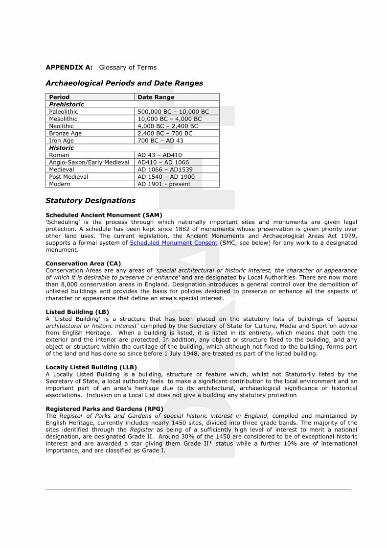
Archaeological Periods and Date Ranges
Period Date Range PrehistoricPaleolithic 500,000 BC – 10,000 BC Mesolithic 10,000 BC – 4,000 BC Neolithic 4,000 BC – 2,400 BC Bronze Age 2,400 BC – 700 BC Iron Age 700 BC – AD 43 HistoricRoman AD 43 – AD410 Anglo-Saxon/Early Medieval AD410 – AD 1066 Medieval AD 1066 – AD1539 Post Medieval AD 1540 – AD 1900 Modern AD 1901 - present
Statutory Designations
Scheduled Ancient Monument (SAM) 'Scheduling' is the process through which nationally important sites and monuments are given legal protection. A schedule has been kept since 1882 of monuments whose preservation is given priority over other land uses. The current legislation, the Ancient Monuments and Archaeological Areas Act 1979, supports a formal system of Scheduled Monument Consent (SMC, see below) for any work to a designated monument.
Conservation Area (CA) Conservation Areas are any areas of ‘special architectural or historic interest, the character or appearance of which it is desirable to preserve or enhance' and are designated by Local Authorities. There are now more than 8,000 conservation areas in England. Designation introduces a general control over the demolition of unlisted buildings and provides the basis for policies designed to preserve or enhance all the aspects of character or appearance that define an area's special interest.
Listed Building (LB) A ‘Listed Building’ is a structure that has been placed on the statutory lists of buildings of 'special architectural or historic interest' compiled by the Secretary of State for Culture, Media and Sport on advice from English Heritage. When a building is listed, it is listed in its entirety, which means that both the exterior and the interior are protected. In addition, any object or structure fixed to the building, and any object or structure within the curtilage of the building, which although not fixed to the building, forms part of the land and has done so since before 1 July 1948, are treated as part of the listed building.
Locally Listed Building (LLB) A Locally Listed Building is a building, structure or feature which, whilst not Statutorily listed by the Secretary of State, a local authority feels to make a significant contribution to the local environment and an important part of an area’s heritage due to its architectural, archaeological significance or historical associations. Inclusion on a Local List does not give a building any statutory protection
Registered Parks and Gardens (RPG) The Register of Parks and Gardens of special historic interest in England, compiled and maintained by English Heritage, currently includes nearly 1450 sites, divided into three grade bands. The majority of the sites identified through the Register as being of a sufficiently high level of interest to merit a national designation, are designated Grade II. Around 30% of the 1450 are considered to be of exceptional historic interest and are awarded a star giving them Grade II* status while a further 10% are of international importance, and are classified as Grade I.
DRAFT
Archaeological Priority Area (APA) An Archaeological Priority Area is an area specified by Local Planning Authorities to help protect archaeological remains that might be affected by development. This means that a site in such an area should be assessed for their archaeological potential when application is made for their redevelopment.
The Planning Process
Scheduled Monument Consent (SMC) The Secretary of State must be informed about any work which might affect a monument above or below ground, and English Heritage gives advice to the Government on each application. In assessing each application the Secretary of State will try to ensure that damage done to protected sites is kept to a minimum. Written consent must always be obtained before any work can begin. Some development may also need planning permission.
Listed Building Consent (LBC) Listed Building Consent (LBC) is required in order to carry out any works to a Listed Building which will affect its special value for listing purposes. This will almost certainly be necessary for any major works, but may also be necessary for minor alterations and possibly even repairs and maintenance. LBC may also be necessary for a change of use of the property. It is a criminal offence to carry out work which needs listed building consent without obtaining it beforehand.
The Archaeological Process
The Principle Stages for handling archaeology within the planning process, in line with the Government's Planning Policy Guidance notes PPG 15 and PPG16 are:
Pre-determination: desk-based assessment, archaeological evaluation
Post-determination: preservation in situ, preservation by record (excavation)
Stages of Archaeological Work
Written Scheme of Investigation (WSI) Any programme of archaeological work will normally be undertaken in accordance with a Written Scheme of Investigation (WSI), clearly stating the scope and extent of work, the aims and objectives, and the methodology to be employed during the course of work. The WSI will be prepared by the contracted archaeological organisation and approved in advance of work by the archaeological officer of the relevant LPA.
Archaeological Desk-Based Assessment (DBA) An archaeological desk-based assessment (DBA) constitutes a first stage, non-invasive assessment of the archaeological potential of a site, undertaken in advance of any development. Research will normally comprise a search of all readily available documentary and archival sources pertaining to a site combined with an on-site ‘walkover’ survey to assess surviving archaeological remains / built heritage of the area.
Archaeological Evaluation An archaeological evaluation is a limited programme of intrusive or non-intrusive fieldwork undertaken to establish the extent of survival of archaeological deposits within a site and to determine the character, date, state of preservation and potential significance of any buried remains. An evaluation is often required prior to the determination of a planning application for development and will normally be undertaken subsequent to a desk-based assessment. A variety of techniques may be employed including geophysical survey, fieldwalking, trial trenching and test pitting. The results of evaluation will be used to establish the necessity for and determine the requirements of any further stage of archaeological work.
Archaeological Excavation
DRAFT
An archaeological excavation is a programme of controlled, intrusive fieldwork, normally undertaken by means of open area excavation, with the purpose of examining and recording archaeological deposits, features and structures identified by documentary research and/or archaeological evaluation. Archaeological excavation will normally lead on to a programme of post-excavation analysis and publication.
Archaeological Watching Brief An archaeological watching brief is a formal programme of observation and investigation conducted during any operation carried out for non-archaeological reasons within an area or site where there is a possibility of archaeological deposits being disturbed or destroyed. Groundworks will normally be undertaken by a principal contractor under the supervision of an attending archaeologist.
Preservation in-situFoundation design to avoid or minimise impact on archaeology may be sought. This might include locating buildings to avoid archaeology; display of remains; sympathetic location of piled foundations and piling techniques; raising floor or ground beam levels; the routing of services; management of ground water. Landscaping and planting may also be constrained. Monitoring over a number of years after completion may be needed to assess if the preservation techniques have been successful.
Historic Building Recording (HBR)
A Historic Building Record (HBR) is a programme of work intended to establish the character, history, dating, form and archaeological development of a specified building, structure or complex and its setting. A programme of historic building recording will often be required as a condition of planning consent / listed building consent, to be taken in advance of (pre-determination) and/or during building refurbishment / alterations / demolitions (post determination). HBR can be undertaken to a range of different levels (Levels 1 – 4 as defined by English Heritage) dependent upon the significance of the building under consideration and the extent of the proposed works.
DRAFT
APPENDIX B: Listed Building Descriptions
(a) Westhill House, Attached Outbuilding and Walls, High Street, Culworth
Grade II Listed (Date of Listing: 04/02/1969)
Westhill House, attached 04/02/69 outbuilding and walls GV II House. Early C17, altered and extended two bays to left (south) late C17. Three right bays coursed limestone rubble banded with ironstone. 2 storeys. Two left bays under one gable, coursed limestone rubble, two storeys with attic. Artifical stone slate roof, brick and stone stacks. U-plan. Blocked three-light stone mullioned window to cellar in second bay from left. Entrance in third bay from right has stone lintel, 6-panel door and timber lattice work porch. Three-light window with wood lintel and old iron casement to left. three-light window with wood lintel and C20 casement to right. Four-light window with wood lintel and old iron casement in right bay. Similar windows in right bay on the first floor and third bay from right. Two-light casement window with wood lintel in second bay from right. Two left bays have Two-light windows with stone lintels and wood mullions and transoms on both floors. Two-light casement window with plain stone frame to attic. Coped gable ends with kneelers flanking gabled wings at rear. Interior not inspected but noted as having a late C17 fireplace with bolection surround in the hall, re-arranged early C17 panelling, and chequer floor of white Culworth stone and black Byfield stone. A bedroom has early C17 panelling with carved frieze and elaborate fireplace surround and overmantel with 2 arches flanked by Doric columns. Outbuilding, adjoining left wing at rear, probably c.1700. Squared coursed ironstone, slate roof, brick stack. One storey, 2 bays. Doorway in right bay with wood lintel, and three-light casement window with wood lintel to left. Interior not inspected. Wall, extending from the east and west fronts of the house along the High Street. C17, squared coursed ironstone with stone coping. West section is L-plan, turning north at an angle to divide the house from the farmyard.
(b) Wall approximately 25m to 35m southeast of Westhill House, High Street, Culworth
Grade II Listed (Date of Listing: 04/08/1985)
Garden wall approx. 25-35m. SE of West-hill House GV II Wall. Early C18. Brick with stone coping. L-plan. Forming part of a three and a half sided garden enclosure at Westhill House (q.v.). Included for group value.
Wall approximately 20m northwest of Westhill House, High Street, Culworth
Grade II Listed (Date of Listing: 04/08/1985)
Wall approx. 20m. NW of Westhill House GV II Wall. C17. Coursed squared ironstone, with stone coping. Part of a former enclosure around Westhill House.
Garden Walls and Gateways approximately 30m to 50m west of Westhill House, High Street, Culworth
Grade II Listed (Date of Listing: 04/08/1985)
Garden walls and gateways approx. 30-50m. W, N and E of Westhill House GV II Walls and gateways. Early C18. Brick walls with stone coping. Wall to west has gateway towards south end with moulded stone frame and a second gateway at the north end with moulded stone frame
DRAFT
and segmental pediment. Similar gateway at north end of east wall. There is a break approximately midway along the east wall, and the garden enclosure is continued by a separate L-shaped section of wall to the south-east (q.v.). Forming part of a three and a half sided garden enclosure at Westhill House (q.v.) Included for group value.
(c) Barn approximately 35m northwest of Westhill House, High Street, Culworth
Grade II Listed (Date of Listing: 02/04/1969)
Barn approx. 35m. NW of 02/04/69 Westhill House GV II Barn. C16/C17. Coursed ironstone rubble, old tile roof. Onen storey with loft. 7 bays, divided by buttresses. Cart entrance in third bay from right with wood lintel. three-light casement windows with wood lintels to ground floor and loft in third bay from left. Doorway with wood lintel in second bay from left. Stone steps to loft entrance in left bay. Coped gable ends with kneelers. Interior: Queen strut roof retains some original timbers.
(d) Granary and Stables approximately 20m south of Westhill House, High Street, Culworth
Grade II Listed (Date of Listing: 04/08/1985)
Granary and stables approx. 35m. S of Westhill House GV II Granary and stables. C17. Coursed squared ironstone, banded with limestone, old tile roof. 4 bays. 4 doorways to stables with wood lintels and plank doors. Stone steps with entrance to granary on left side. Doorway with wood lintel and plank door. Interior not inspected.
(e) Danvers House East and Danvers House West, High Street, Culworth
Grade II Listed (Date of Listing: 02/04/1969)
Danvers House East and Danvers 04/02/69 House West II House, now two dwellings. Early C18, probably incorporating earlier work, enlarged mid C18 and C19. Sundial dated 1732 at rear of Danvers House East. Ironstone ashlar and coursed ironstone rubble, roof covered by snow at time of survey, brick stacks, irregular U-plan. Main block, early C18, of different builds, runs east to west, and has two irregularly spaced wings with hipped roofs projecting from the north front. East wing, C19, two storeys, 4 bays. Section of main block set back to right, 2 storeys and attic, 2 bays. West wing, mid C18, 2 storeys and cellar. Section of main block set back to right, 2 storeys and attic, 2 bays. Entrance in second bay from right has flat stone frame with keyblock and 6-panel door with overlight. Sash window to right has flat stone frame with keyblock. Similar windows on the first floor. Parapet with segmental pediment. West wing has angle pilasters and moulded cornice. 4 blocked 2-light cellar windows with flat stone mullions, except in that in second bay from right which is boarded over. Sash windows with flat stone frames and keyblocks on both floors. Section of main block to left has entrance on right bay with flat stone frame and keyblock and 6-panel door with fanlight. Sash window to left with flat stone frame and keyblock. Similar windows to first floor. Parapet with segmental pediment. East wing has 4-pane sash windows with flat stone frames and keyblocks to both floors. Interior: Danvers House East. remodelled C20. Danvers House West, not inspected but said to have C18 staircase with Doric newel posts and turned balusters, and a C17 fireplace. Said to have been built in the early C18 on older foundations by Sir John D'Anvers.
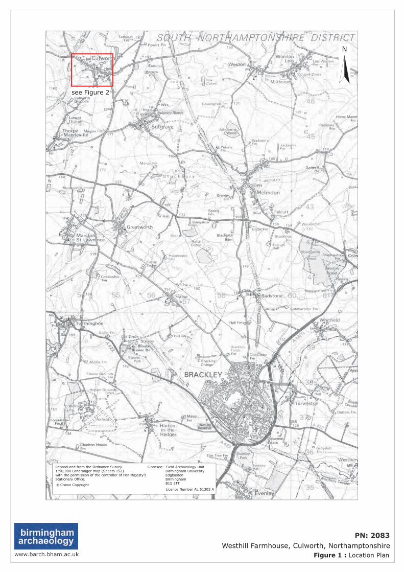
DRAFT
www.barch.bham.ac.uk Figure 1 : Location Plan
PN: 2083Westhill Farmhouse, Culworth, Northamptonshire
see Figure 2
N
Reproduced from the Ordnance Survey1:50,000 Landranger map (Sheets 152)with the permission of the controller of Her Majesty’sStationery Office.
c Licence Number AL 51303 A
Licensee: Field Archaeology Unit Birmingham University Edgbaston Birmingham B15 2TTCrown Copyright
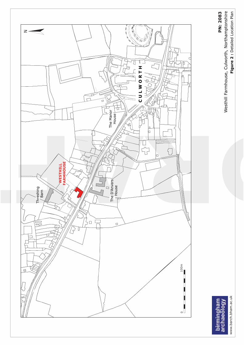
DRAFTw
ww
.bar
ch.b
ham
.ac.
uk
Fig
ure
2 :
Det
aile
d L
oca
tion P
lan
P
N:
20
83
Wes
thill
Far
mhouse
, Culw
ort
h,
Nort
ham
pto
nsh
ire
N
C U
L W
O R
T H
The
Man
or
House
The
D’A
nve
rsH
ouse
WES
TH
ILL
FA
RM
HO
US
E
Thre
shin
gBar
n
0100m
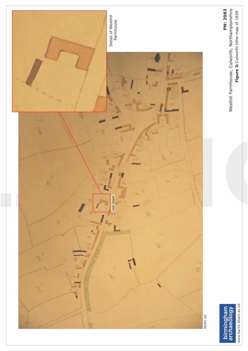
DRAFTw
ww
.bar
ch.b
ham
.ac.
uk
Fig
ure
3:C
ulw
ort
h t
ithe
map
of
1839
P
N:
20
83
Wes
thill
Farm
house
, Culw
ort
h,
Nort
ham
pto
nsh
ire
see
inse
tD
etai
l of W
esth
illFa
rmhouse
NCRO
ref
.
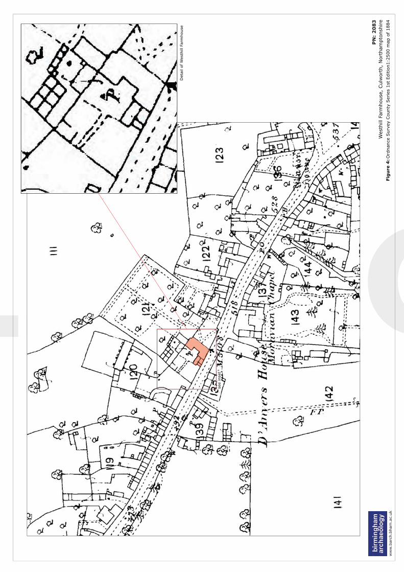
DRAFTw
ww
.bar
ch.b
ham
.ac.
uk
Fig
ure
4: O
rdnan
ce S
urv
ey C
ounty
Ser
ies
1st
Editio
n1:2
500 m
ap o
f 1884
P
N:
20
83
Wes
thill
Farm
house
, Culw
ort
h,
Nort
ham
pto
nsh
ire
Det
ail of W
esth
illFa
rmhouse
see
inse
t
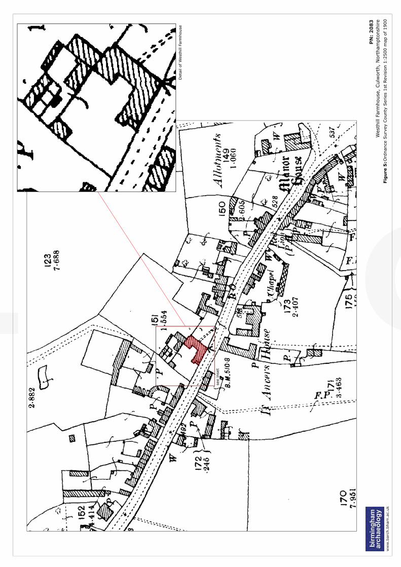
DRAFTw
ww
.bar
ch.b
ham
.ac.
uk
Fig
ure
5:O
rdnan
ce S
urv
ey C
ounty
Ser
ies
1st
Rev
isio
n 1
:2500 m
ap o
f 1900
P
N:
20
83
Wes
thill
Farm
house
, Culw
ort
h,
Nort
ham
pto
nsh
ire
Det
ail of W
esth
illFa
rmhouse
see
inse
t
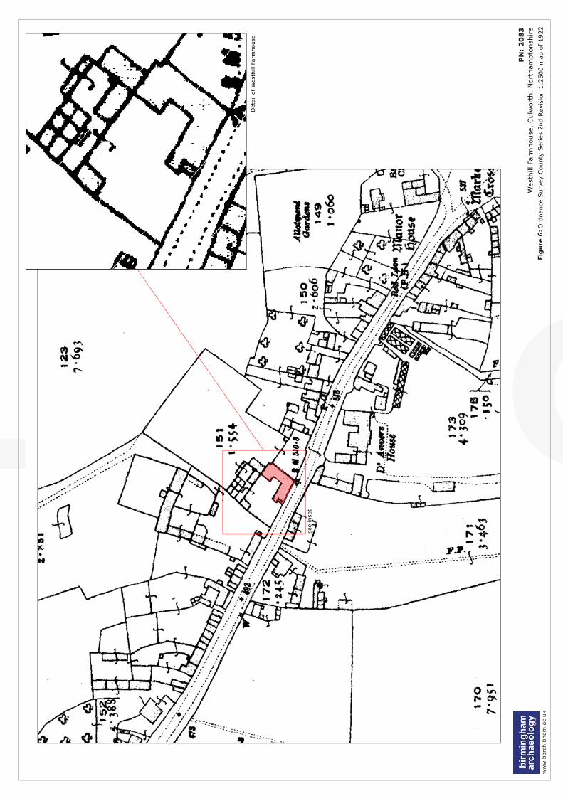
DRAFTw
ww
.bar
ch.b
ham
.ac.
uk
Fig
ure
6:O
rdnan
ce S
urv
ey C
ounty
Ser
ies
2nd
Rev
isio
n 1
:2500 m
ap o
f 1922
P
N:
20
83
Wes
thill
Farm
house
, Culw
ort
h,
Nort
ham
pto
nsh
ire
Det
ail of W
esth
illFa
rmhouse
see
inse
t
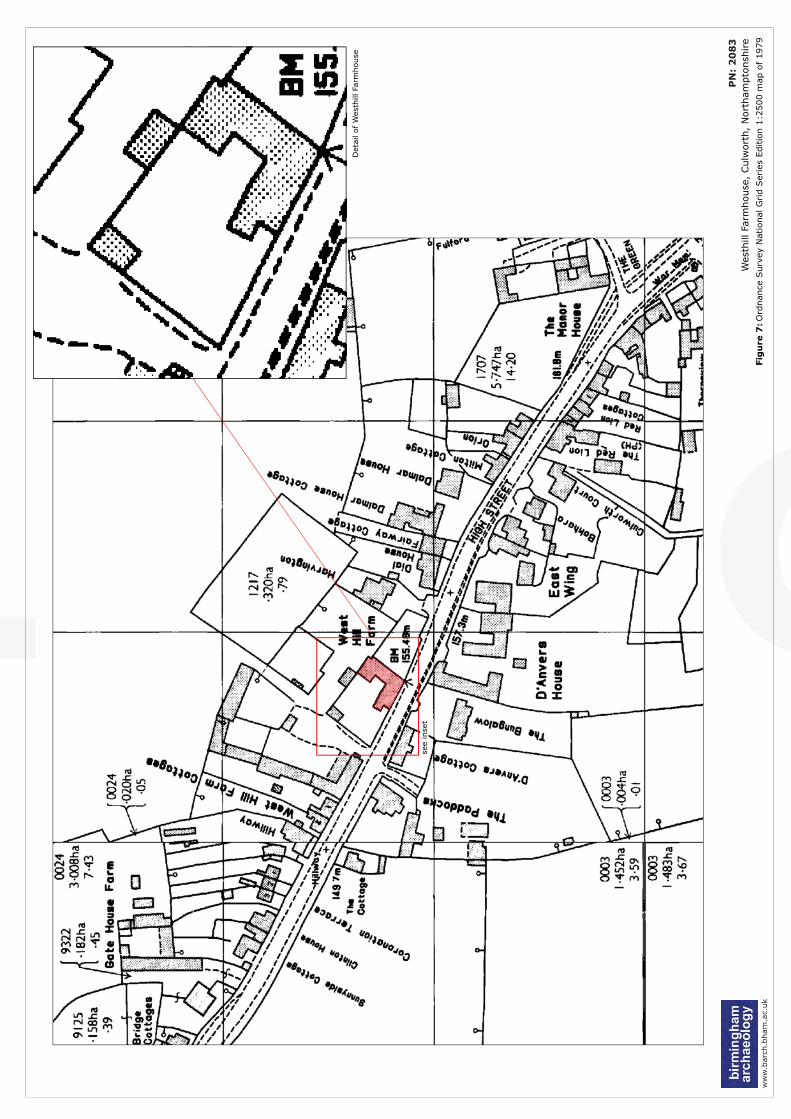
DRAFTw
ww
.bar
ch.b
ham
.ac.
uk
Fig
ure
7:O
rdnan
ce S
urv
ey N
atio
nal
Grid S
erie
s Editio
n 1
:2500 m
ap o
f 1979
P
N:
20
83
Wes
thill
Farm
house
, Culw
ort
h,
Nort
ham
pto
nsh
ire
Det
ail of W
esth
illFa
rmhouse
see
inse
t
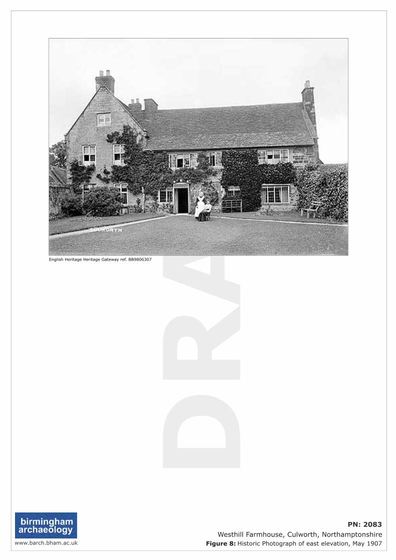
DRAFT
www.barch.bham.ac.uk Figure 8: Historic Photograph of east elevation, May 1907
PN: 2083Westhill Farmhouse, Culworth, Northamptonshire
English Heritage Heritage Gateway ref. BB9806307
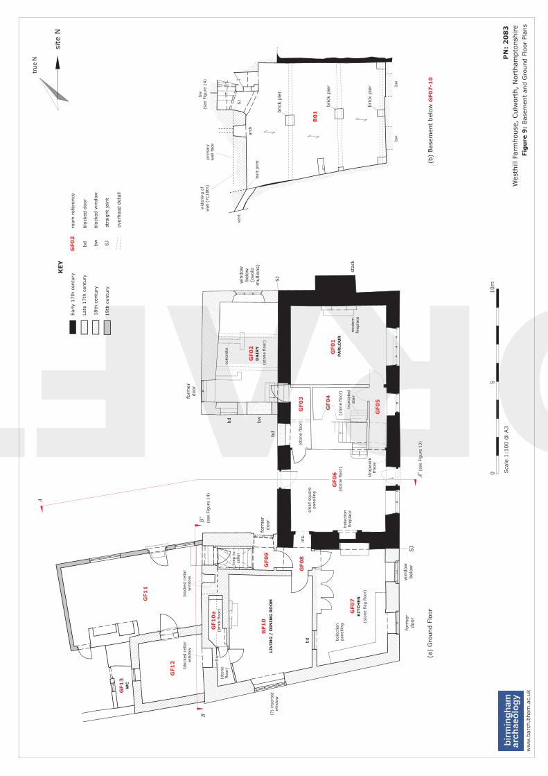
DRAFTfo
rmer
door
SJ
KEY
Ear
ly 1
7th
cen
tury
Late
17th
cen
tury
brick
pie
r
brick
pie
r
brick
pie
r
win
dow
bel
ow
bole
ctio
nfire
pla
ce
ins.
form
erdoor
bd bw
bd
moder
nfire
pla
ce
bole
ctio
npan
ellin
g
bd
18th
cen
tury
19th
cen
tury
bd
blo
cked
door
bw
b
lock
ed w
indow
SJ
stra
ight
join
t
over
hea
d d
etai
l
stac
k
win
dow
bel
ow
(ovo
lom
ulli
ons)
SJ
form
erdoor
bw
(see
Fig
ure
14)
vent
concr
ete
DA
IRY
(sto
ne
floor)
PA
RLO
UR
(sto
ne
floor)
(sto
ne
floor)
KIT
CH
EN
(sto
ne
flag
flo
or)
LIV
ING
/ D
ININ
G R
OO
M
(sto
ne
floor)
wid
enin
g o
fw
all (?
C18th
)
ww
w.b
arch
.bham
.ac.
uk
Fig
ure
9:
Bas
emen
t an
d G
round F
loor
Plan
s
P
N:
20
83
Wes
thill
Farm
house
, Culw
ort
h,
Nort
ham
pto
nsh
ire
05
Sca
le 1
:100 @
A3
10m
tru
e N
GF0
1
GF0
2
GF0
6
GF0
5
GF0
4
GF0
3
GF0
7
GF1
0
GF1
1
GF1
2
GF1
3
GF0
8
GF0
9
(a)
Gro
und F
loor
(b)
Bas
emen
t bel
ow
GF0
7-1
0
(sto
ne
floor)
GF0
2ro
om
ref
eren
ce
A
A'(s
ee F
igure
13)
blo
cked
cel
lar
win
dow
butt
join
t
SJ
arch
bw
bw
site
N
GF1
0a
B'B
(see
Fig
ure
14)
trunca
ted
stai
r
smal
l sq
uar
epan
ellin
g
stra
pw
ork
frie
ze
(brick
flo
or)
(?)
inse
rted
win
dow
blo
cked
cel
lar
win
dow
bw
WC
trap
to
cella
r
B0
1
prim
ary
wal
l fa
ce
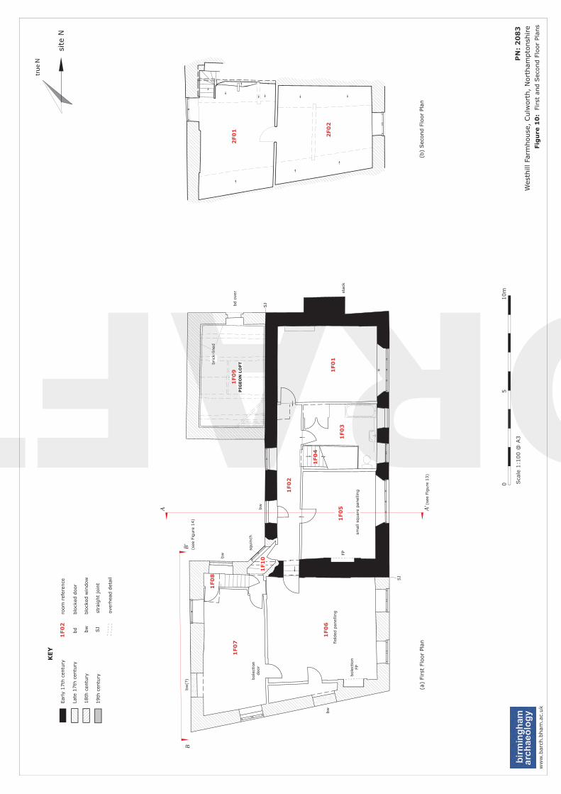
DRAFTw
ww
.bar
ch.b
ham
.ac.
uk
Fig
ure
10
: Fi
rst
and S
econd F
loor
Plan
s
P
N:
20
83
Wes
thill
Farm
house
, Culw
ort
h,
Nort
ham
pto
nsh
ire
05
Sca
le 1
:100 @
A3
10m
(a)
Firs
t Fl
oor
Plan
(b)
Sec
ond F
loor
Plan
KEY
Ear
ly 1
7th
cen
tury
Late
17th
cen
tury
18th
cen
tury
19th
cen
tury
bd
blo
cked
door
bw
b
lock
ed w
indow
SJ
stra
ight
join
t
over
hea
d d
etai
l
1F0
2ro
om
ref
eren
ce
bw
(?)
bw
bw
bw
squin
ch
SJ
bd
over
SJ
stac
k
1F0
1
1F0
2
1F0
31
F0
5
1F0
6
1F0
7
1F0
8
1F0
4
1F1
0
1F0
92
F0
1
2F0
2
A A'
tru
e N
site
N
fiel
ded
pan
ellin
g
FP
bole
ctio
ndoor
bole
ctio
nFP
smal
l sq
uar
e pan
ellin
g
B'B
(see
Fig
ure
14)
(see
Fig
ure
13)
PIG
EO
N L
OFTbrick
-lin
ed
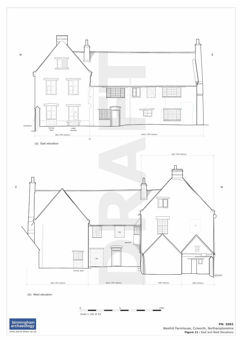
DRAFT
?
bd
bw
www.barch.bham.ac.uk
0 5
Scale 1:100 @ A3
10m
(a) East elevation
W E
(b) West elevation
E W
early 17th centurylate 17th century
ironstoneformerdoor
former door
squinch
Figure 11 : East and West Elevations
PN: 2083Westhill Farmhouse, Culworth, Northamptonshire
cellarwindow
SJ
early 17th centurylate 17th century 18th century19th century
late 17th century
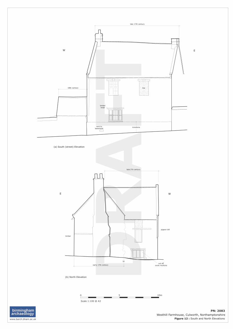
DRAFT
cut offovolo mullions
late17th century
early 17th century
(b) North Elevation
SJ
pigeon loft
timber
E W
EW
bw
timberlintel
ironstonevent tobasement
late 17th century
18th century
(a) South (street) Elevation
www.barch.bham.ac.uk
0 5
Scale 1:100 @ A3
10m
Figure 12 : South and North Elevations
PN: 2083Westhill Farmhouse, Culworth, Northamptonshire
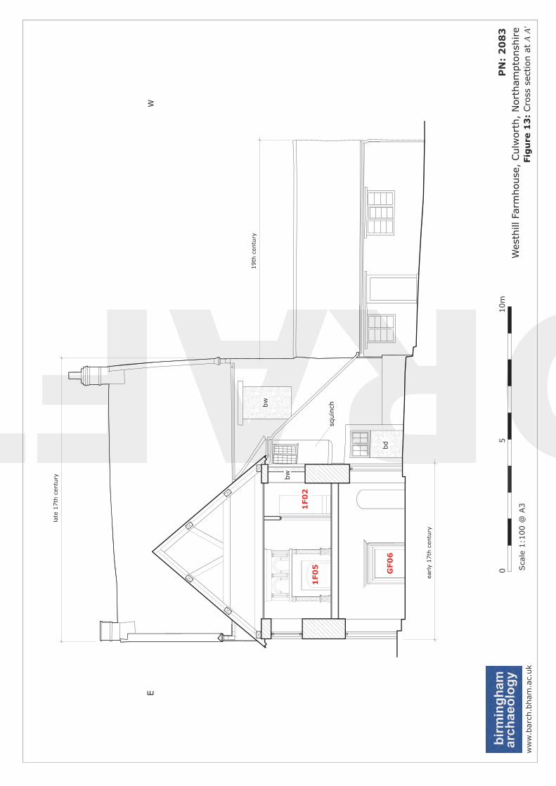
DRAFTbd
bw
squin
ch
ww
w.b
arch
.bham
.ac.
uk
Fig
ure
13
: Cro
ss s
ection a
t A
A'
P
N:
20
83
Wes
thill
Farm
house
, Culw
ort
h,
Nort
ham
pto
nsh
ire
05
Sca
le 1
:100 @
A3
10m
E
late
17th
cen
tury
W
early
17th
cen
tury
19th
cen
tury
1F0
51
F0
2
GF0
6
bw
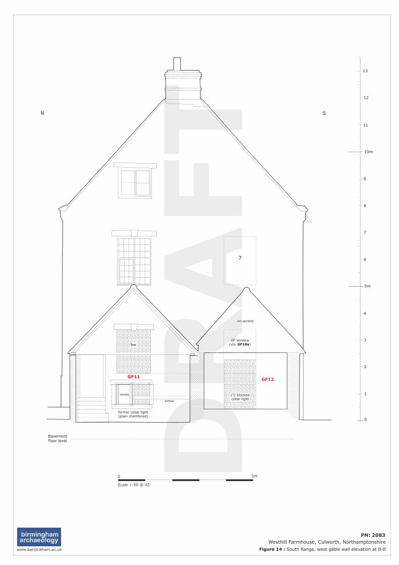
DRAFT
?
0 5m
Scale 1:50 @ A3
10m
5m
0
1
2
3
4
6
7
8
9
11
Basementfloor level
no access
former cellar light(plain chamfered)
bw
recess
timber
GF11GF12
12
13
GF window(vis. GF10a)
(?) blockedcellar light
N S
www.barch.bham.ac.uk Figure 14 : South Range, west gable wall elevation at B-B'
PN: 2083Westhill Farmhouse, Culworth, Northamptonshire

DRAFT
PN: 2083 Westhill Farmhouse, Culworth, Northamptonshire
Historic Building Record
Plate 1: Aerial view of Westhill Farmhouse (© Google Earth).
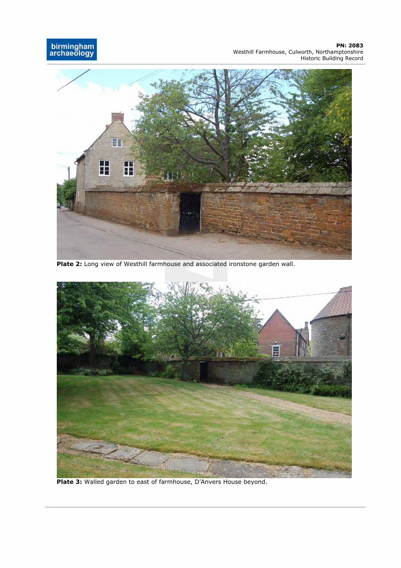
DRAFT
PN: 2083 Westhill Farmhouse, Culworth, Northamptonshire
Historic Building Record
Plate 2: Long view of Westhill farmhouse and associated ironstone garden wall.
Plate 3: Walled garden to east of farmhouse, D’Anvers House beyond.
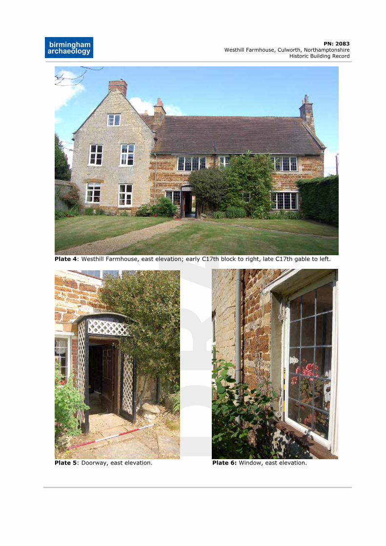
DRAFT
PN: 2083 Westhill Farmhouse, Culworth, Northamptonshire
Historic Building Record
Plate 4: Westhill Farmhouse, east elevation; early C17th block to right, late C17th gable to left.
Plate 5: Doorway, east elevation. Plate 6: Window, east elevation.
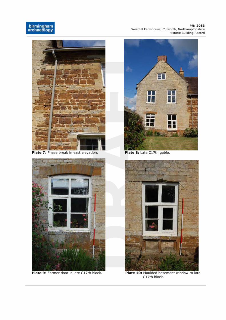
DRAFT
PN: 2083 Westhill Farmhouse, Culworth, Northamptonshire
Historic Building Record
Plate 7: Phase break in east elevation. Plate 8: Late C17th gable.
Plate 9: Former door in late C17th block. Plate 10: Moulded basement window to late
C17th block.
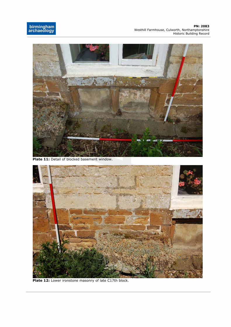
DRAFT
PN: 2083 Westhill Farmhouse, Culworth, Northamptonshire
Historic Building Record
Plate 11: Detail of blocked basement window.
Plate 12: Lower ironstone masonry of late C17th block.
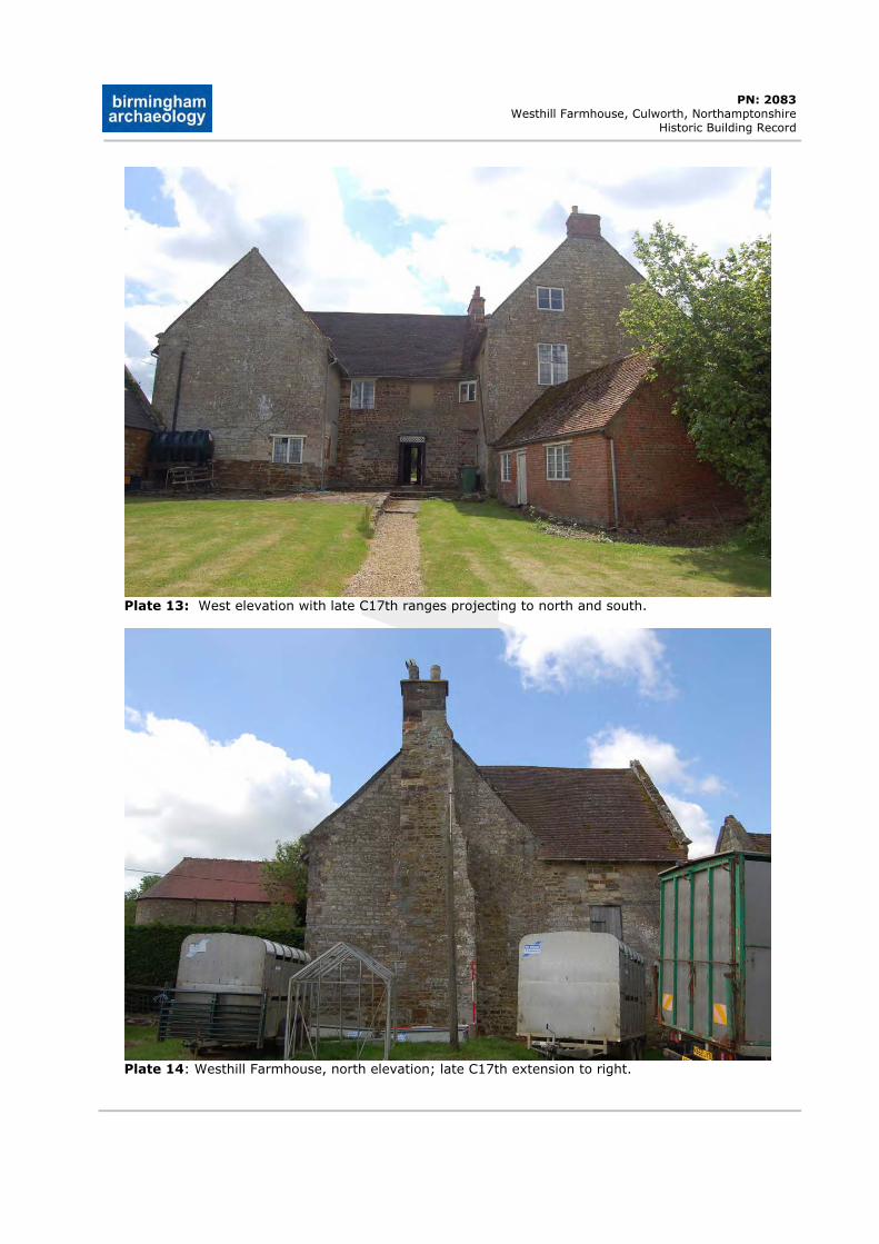
DRAFT
PN: 2083 Westhill Farmhouse, Culworth, Northamptonshire
Historic Building Record
Plate 13: West elevation with late C17th ranges projecting to north and south.
Plate 14: Westhill Farmhouse, north elevation; late C17th extension to right.
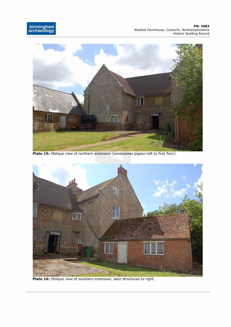
DRAFT
PN: 2083 Westhill Farmhouse, Culworth, Northamptonshire
Historic Building Record
Plate 15: Oblique view of northern extension (windowless pigeon-loft to first floor).
Plate 16: Oblique view of southern extension, later structures to right.
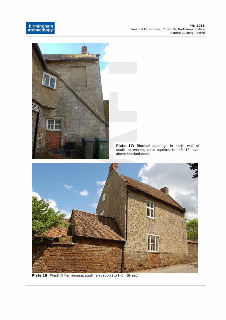
DRAFT
PN: 2083 Westhill Farmhouse, Culworth, Northamptonshire
Historic Building Record
Plate 17: Blocked openings in north wall of south extension, note squinch to left 1F level above blocked door.
Plate 18: Westhill Farmhouse, south elevation (to High Street).
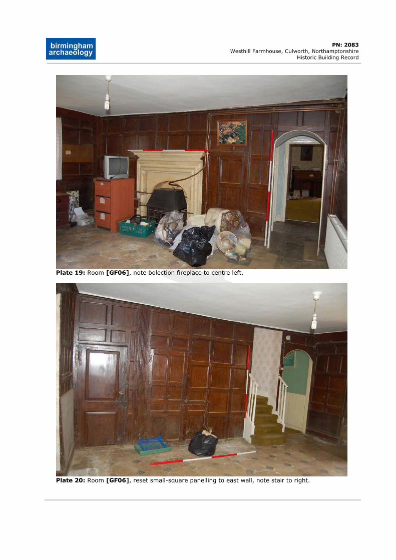
DRAFT
PN: 2083 Westhill Farmhouse, Culworth, Northamptonshire
Historic Building Record
Plate 19: Room [GF06], note bolection fireplace to centre left.
Plate 20: Room [GF06], reset small-square panelling to east wall, note stair to right.
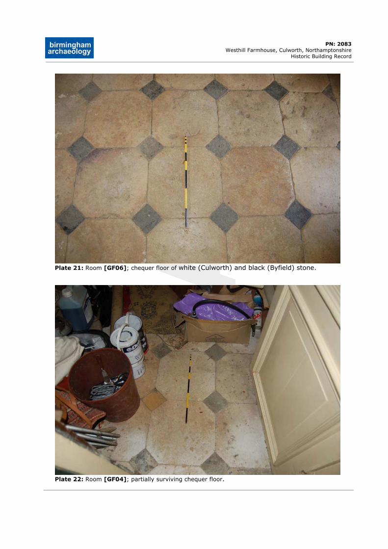
DRAFT
PN: 2083 Westhill Farmhouse, Culworth, Northamptonshire
Historic Building Record
Plate 21: Room [GF06]; chequer floor of white (Culworth) and black (Byfield) stone.
Plate 22: Room [GF04]; partially surviving chequer floor.
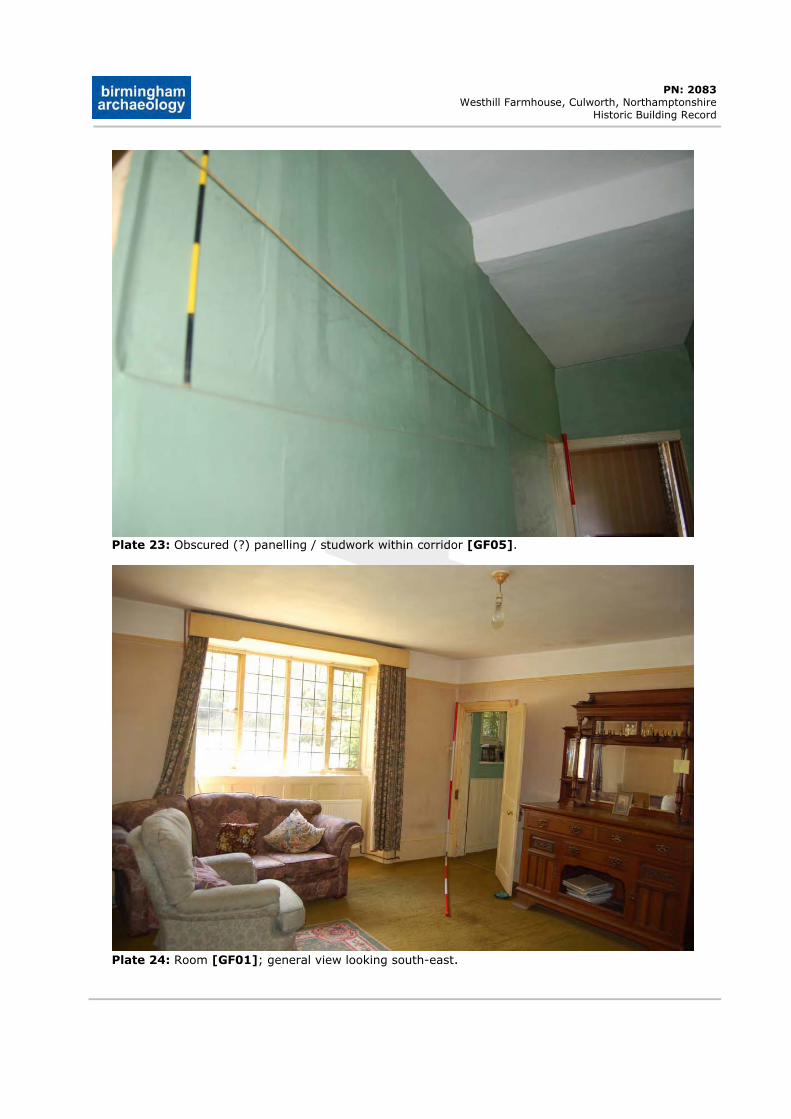
DRAFT
PN: 2083 Westhill Farmhouse, Culworth, Northamptonshire
Historic Building Record
Plate 23: Obscured (?) panelling / studwork within corridor [GF05].
Plate 24: Room [GF01]; general view looking south-east.
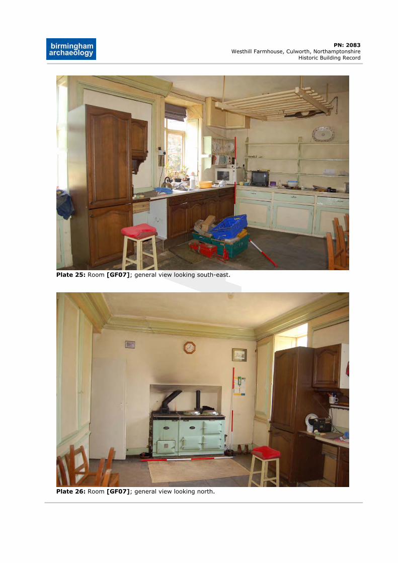
DRAFT
PN: 2083 Westhill Farmhouse, Culworth, Northamptonshire
Historic Building Record
Plate 25: Room [GF07]; general view looking south-east.
Plate 26: Room [GF07]; general view looking north.
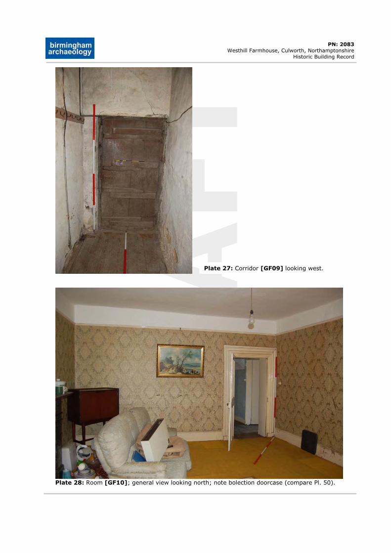
DRAFT
PN: 2083 Westhill Farmhouse, Culworth, Northamptonshire
Historic Building Record
Plate 27: Corridor [GF09] looking west.
Plate 28: Room [GF10]; general view looking north; note bolection doorcase (compare Pl. 50).
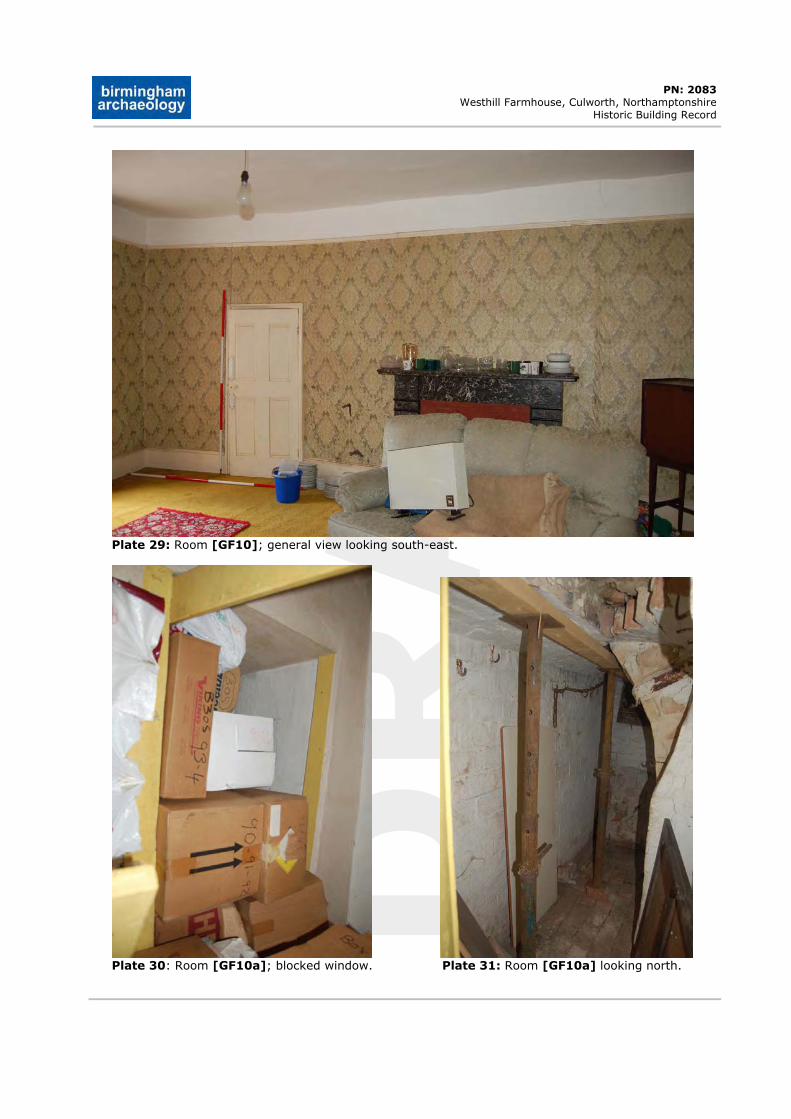
DRAFT
PN: 2083 Westhill Farmhouse, Culworth, Northamptonshire
Historic Building Record
Plate 29: Room [GF10]; general view looking south-east.
Plate 30: Room [GF10a]; blocked window. Plate 31: Room [GF10a] looking north.
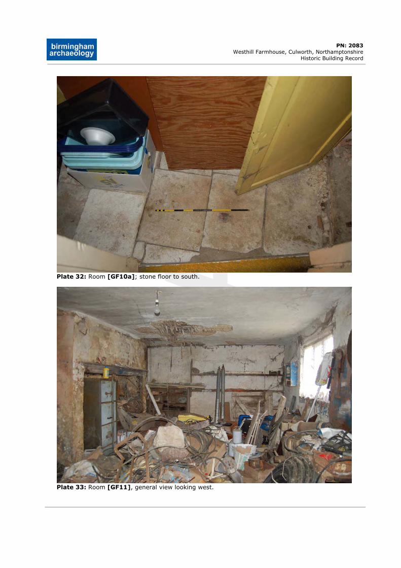
DRAFT
PN: 2083 Westhill Farmhouse, Culworth, Northamptonshire
Historic Building Record
Plate 32: Room [GF10a]; stone floor to south.
Plate 33: Room [GF11], general view looking west.
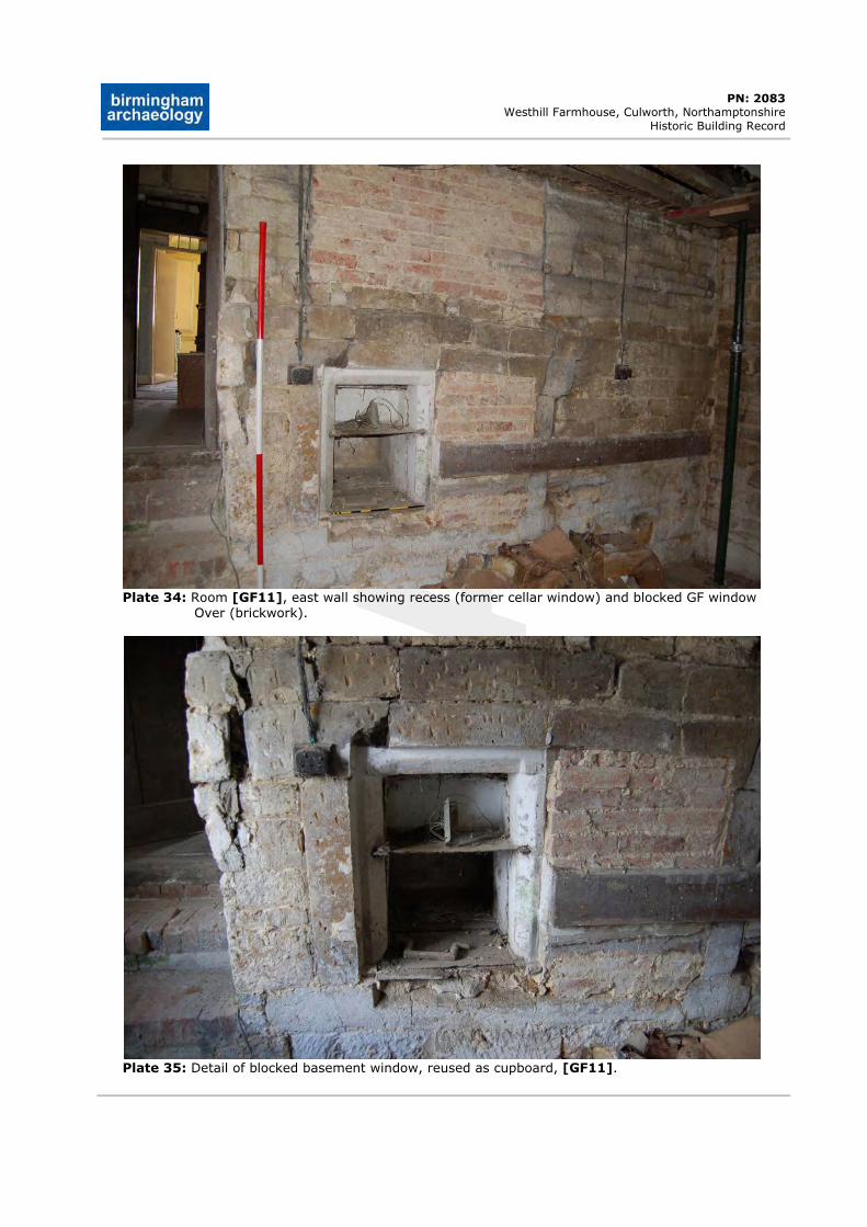
DRAFT
PN: 2083 Westhill Farmhouse, Culworth, Northamptonshire
Historic Building Record
Plate 34: Room [GF11], east wall showing recess (former cellar window) and blocked GF window Over (brickwork).
Plate 35: Detail of blocked basement window, reused as cupboard, [GF11].
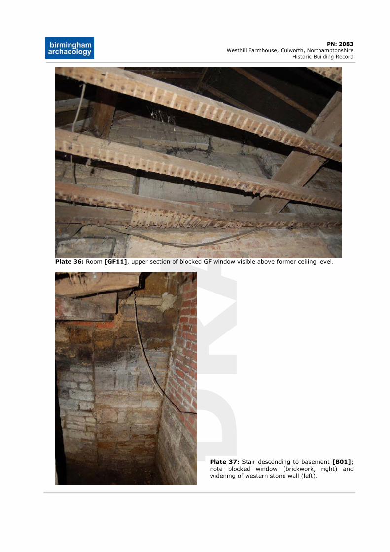
DRAFT
PN: 2083 Westhill Farmhouse, Culworth, Northamptonshire
Historic Building Record
Plate 36: Room [GF11], upper section of blocked GF window visible above former ceiling level.
Plate 37: Stair descending to basement [B01];note blocked window (brickwork, right) and widening of western stone wall (left).
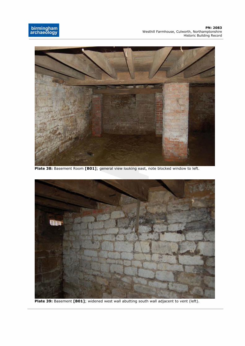
DRAFT
PN: 2083 Westhill Farmhouse, Culworth, Northamptonshire
Historic Building Record
Plate 38: Basement Room [B01]; general view looking east, note blocked window to left.
Plate 39: Basement [B01]; widened west wall abutting south wall adjacent to vent (left).
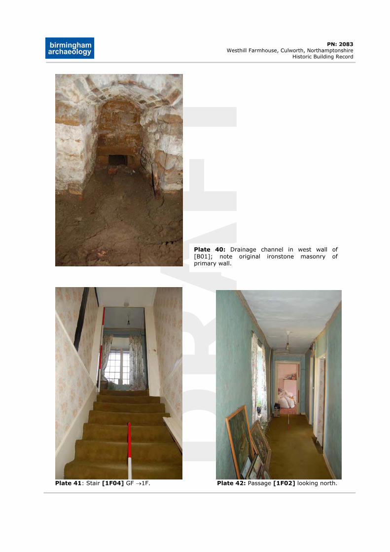
DRAFT
PN: 2083 Westhill Farmhouse, Culworth, Northamptonshire
Historic Building Record
Plate 40: Drainage channel in west wall of [B01]; note original ironstone masonry of primary wall.
Plate 41: Stair [1F04] GF 1F. Plate 42: Passage [1F02] looking north.
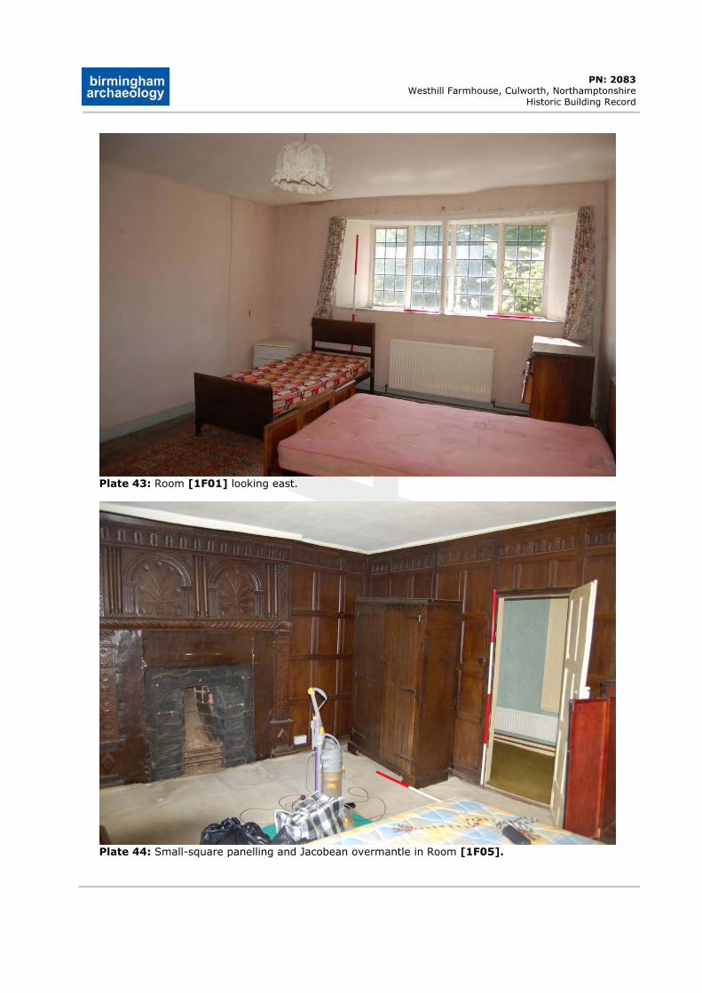
DRAFT
PN: 2083 Westhill Farmhouse, Culworth, Northamptonshire
Historic Building Record
Plate 43: Room [1F01] looking east.
Plate 44: Small-square panelling and Jacobean overmantle in Room [1F05].
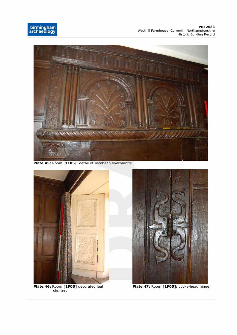
DRAFT
PN: 2083 Westhill Farmhouse, Culworth, Northamptonshire
Historic Building Record
Plate 45: Room [1F05]; detail of Jacobean overmantle.
Plate 46: Room [1F05] decorated leaf Plate 47: Room [1F05]; cocks-head hinge. shutter.
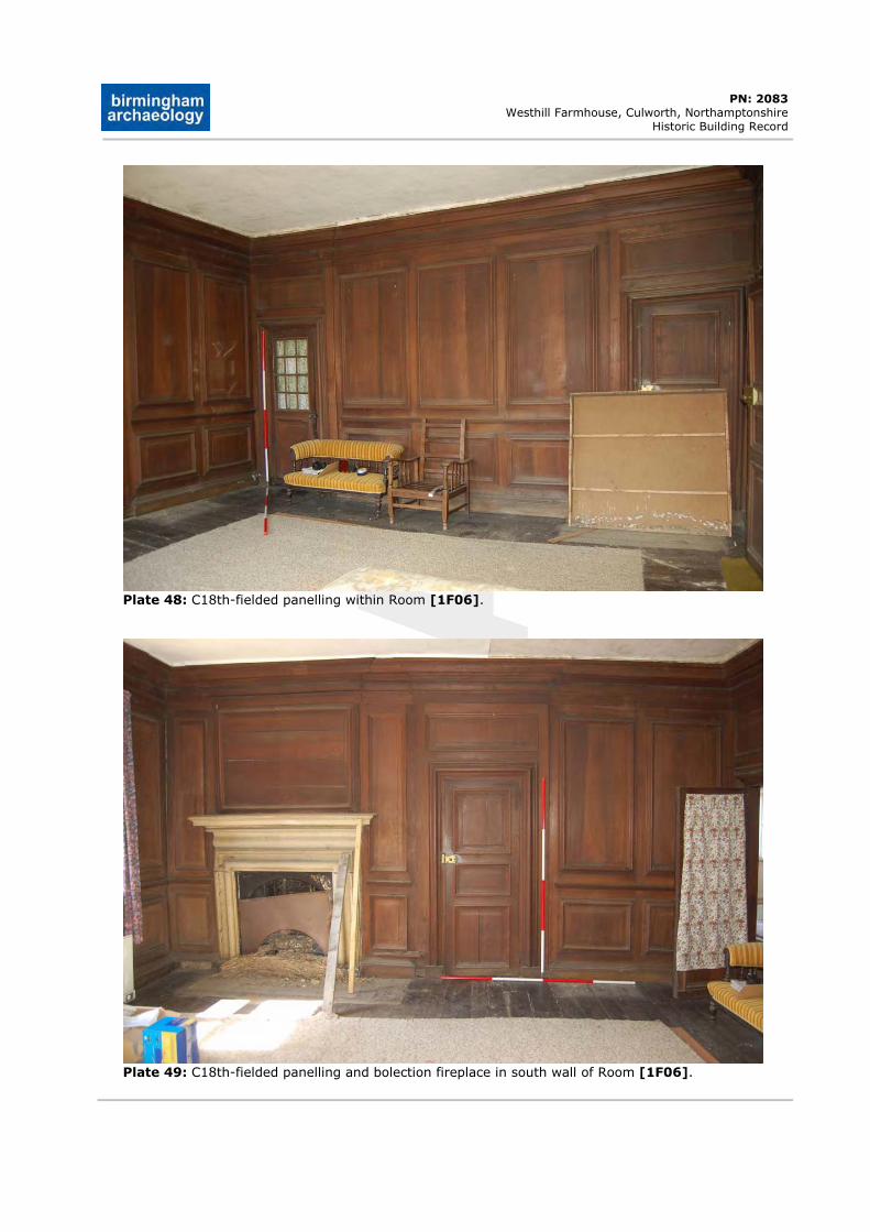
DRAFT
PN: 2083 Westhill Farmhouse, Culworth, Northamptonshire
Historic Building Record
Plate 48: C18th-fielded panelling within Room [1F06].
Plate 49: C18th-fielded panelling and bolection fireplace in south wall of Room [1F06].
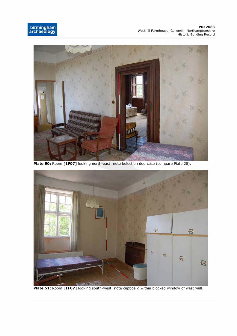
DRAFT
PN: 2083 Westhill Farmhouse, Culworth, Northamptonshire
Historic Building Record
Plate 50: Room [1F07] looking north-east; note bolection doorcase (compare Plate 28).
Plate 51: Room [1F07] looking south-west; note cupboard within blocked window of west wall.
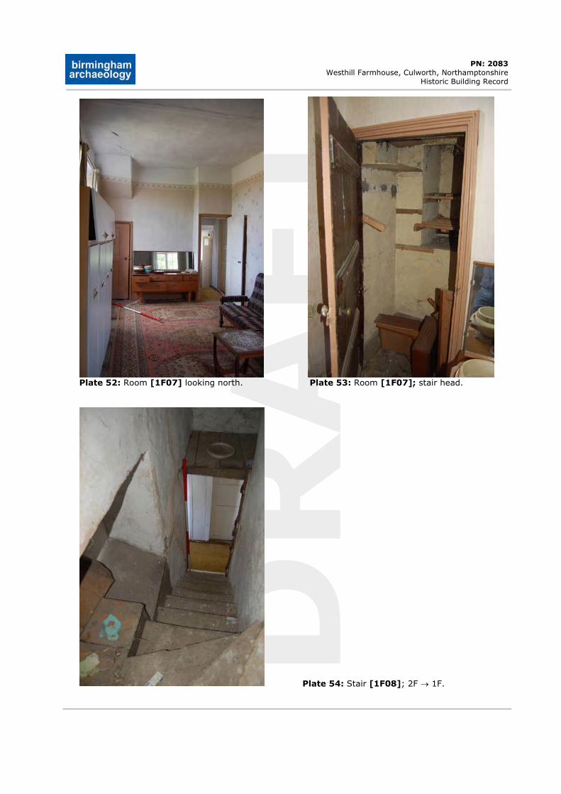
DRAFT
PN: 2083 Westhill Farmhouse, Culworth, Northamptonshire
Historic Building Record
Plate 52: Room [1F07] looking north. Plate 53: Room [1F07]; stair head.
Plate 54: Stair [1F08]; 2F 1F.
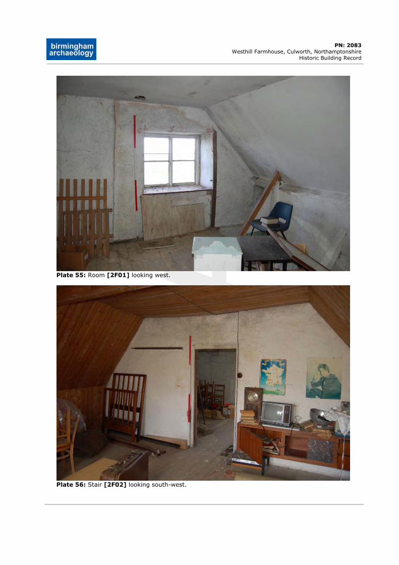
DRAFT
PN: 2083 Westhill Farmhouse, Culworth, Northamptonshire
Historic Building Record
Plate 55: Room [2F01] looking west.
Plate 56: Stair [2F02] looking south-west.
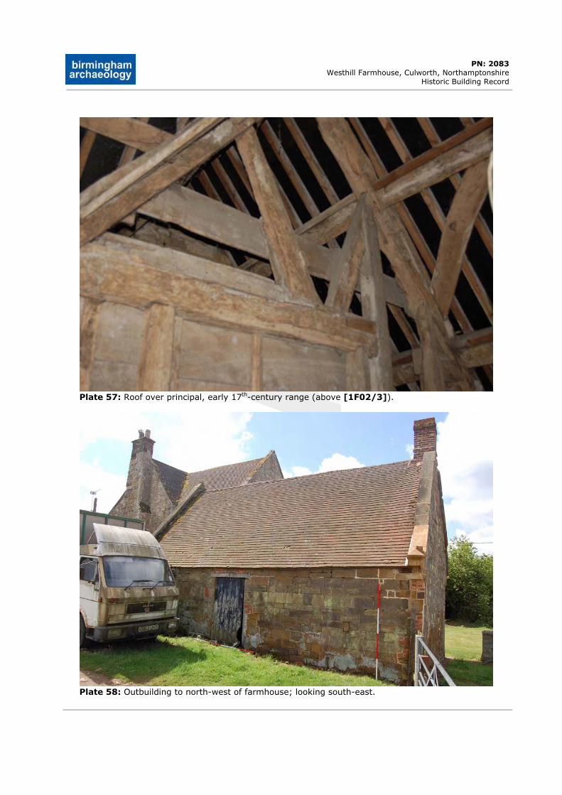
DRAFT
PN: 2083 Westhill Farmhouse, Culworth, Northamptonshire
Historic Building Record
Plate 57: Roof over principal, early 17th-century range (above [1F02/3]).
Plate 58: Outbuilding to north-west of farmhouse; looking south-east.
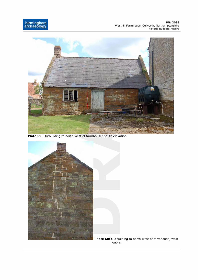
DRAFT
PN: 2083 Westhill Farmhouse, Culworth, Northamptonshire
Historic Building Record
Plate 59: Outbuilding to north-west of farmhouse; south elevation.
Plate 60: Outbuilding to north-west of farmhouse, west gable.
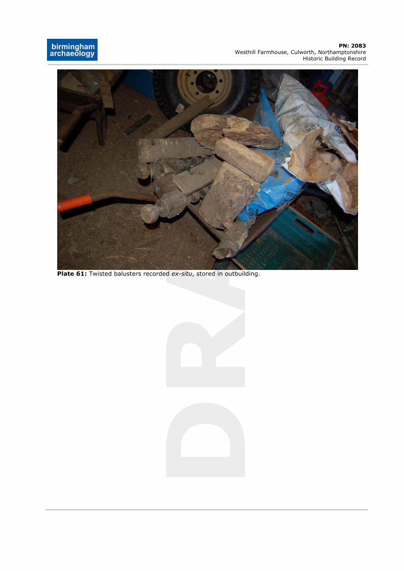
DRAFT
PN: 2083 Westhill Farmhouse, Culworth, Northamptonshire
Historic Building Record
Plate 61: Twisted balusters recorded ex-situ, stored in outbuilding.


![Wave packet study of the UV photodissociation of the Ar[sub 2]HBr complex](https://img.dokumen.tips/doc/110x75/634a69c1913672970c0884d4/wave-packet-study-of-the-uv-photodissociation-of-the-arsub-2hbr-complex.jpg)


