Embed Size (px)
Citation preview
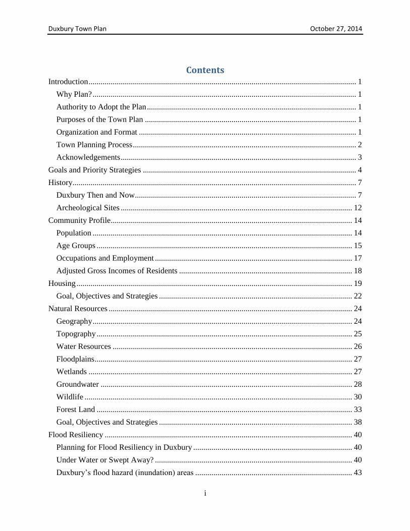
Town of Duxbury, Vermont
Town Plan
Adopted October 27, 2014

Duxbury Town Plan October 27, 2014
i
Contents Introduction ..................................................................................................................................... 1
Why Plan? ................................................................................................................................... 1
Authority to Adopt the Plan ........................................................................................................ 1
Purposes of the Town Plan ......................................................................................................... 1
Organization and Format ............................................................................................................ 1
Town Planning Process ............................................................................................................... 2
Acknowledgements ..................................................................................................................... 3
Goals and Priority Strategies .......................................................................................................... 4
History............................................................................................................................................. 7
Duxbury Then and Now.............................................................................................................. 7
Archeological Sites ................................................................................................................... 12
Community Profile........................................................................................................................ 14
Population ................................................................................................................................. 14
Age Groups ............................................................................................................................... 15
Occupations and Employment .................................................................................................. 17
Adjusted Gross Incomes of Residents ...................................................................................... 18
Housing ......................................................................................................................................... 19
Goal, Objectives and Strategies ................................................................................................ 22
Natural Resources ......................................................................................................................... 24
Geography ................................................................................................................................. 24
Topography ............................................................................................................................... 25
Water Resources ....................................................................................................................... 26
Floodplains ................................................................................................................................ 27
Wetlands ................................................................................................................................... 27
Groundwater ............................................................................................................................. 28
Wildlife ..................................................................................................................................... 30
Forest Land ............................................................................................................................... 33
Goal, Objectives and Strategies ................................................................................................ 38
Flood Resiliency ........................................................................................................................... 40
Planning for Flood Resiliency in Duxbury ............................................................................... 40
Under Water or Swept Away? .................................................................................................. 40
Duxbury’s flood hazard (inundation) areas .............................................................................. 43
Duxbury Town Plan October 27, 2014
ii
Stream Assessments .................................................................................................................. 49
River Corridor Overlay ............................................................................................................. 51
Riparian Buffers ........................................................................................................................ 52
Dams ......................................................................................................................................... 52
Wetlands ................................................................................................................................... 53
Forest Resources ....................................................................................................................... 53
Emergency Response Planning ................................................................................................. 53
Goal, Objectives and Strategies ................................................................................................ 54
Land Use ....................................................................................................................................... 56
Zoning Districts ........................................................................................................................ 56
Special Limitation on Large Land Developments .................................................................... 61
River Corridor Overlay ............................................................................................................. 62
Planned Unit Developments ..................................................................................................... 63
Goal, Objectives and Strategies ................................................................................................ 63
Economic Development ................................................................................................................ 65
Current Economy and Jobs ....................................................................................................... 65
Community and Economic Development Opportunities .......................................................... 66
Goal, Objectives and Strategies ................................................................................................ 67
Food and Agriculture .................................................................................................................... 69
The Importance of Our Food System........................................................................................ 69
Agricultural History .................................................................................................................. 70
Agricultural and Food Systems Today ..................................................................................... 70
Agricultural and Food System Resources ................................................................................. 72
Community efforts to support agriculture and food security .................................................... 74
Goal, Objectives and Strategies ................................................................................................ 75
Transportation ............................................................................................................................... 77
Duxbury’s Transportation Network .......................................................................................... 77
Public Transportation Systems ................................................................................................. 81
Freight and Goods Movement .................................................................................................. 82
Transportation Trends and Themes .......................................................................................... 83
Goal, Objectives and Strategies ................................................................................................ 85
Education ...................................................................................................................................... 88
Current Educational Operations ................................................................................................ 88
Goal, Objectives and Strategies ................................................................................................ 90
Duxbury Town Plan October 27, 2014
iii
Community Utilities, Facilities and Services................................................................................ 91
Cemeteries................................................................................................................................. 91
Duxbury Land Trust .................................................................................................................. 92
Fire Protection ........................................................................................................................... 92
Health and Ambulance Services ............................................................................................... 93
Police......................................................................................................................................... 94
Recreation ................................................................................................................................. 94
Wastewater Systems ................................................................................................................. 95
Solid Waste and Recycling ....................................................................................................... 95
Telecommunications Towers .................................................................................................... 96
Town Properties ........................................................................................................................ 96
Water Supply ............................................................................................................................ 97
Goal, Objectives and Strategies ................................................................................................ 97
Energy ........................................................................................................................................... 99
Energy Overview ...................................................................................................................... 99
Land Use and Energy .............................................................................................................. 100
Renewable Energy .................................................................................................................. 100
Goal, Objectives and Strategies .............................................................................................. 101
Maps ............................................................................................................................................ 103
Maps Map 1 Natural Features
Map 2 Zoning
Map 3 Transportation
Map 4 Housing Distribution (preliminary draft)
Map 5 Education, Utilities and Facilities

Duxbury Town Plan October 27, 2014
1
Introduction
Why Plan? Why should communities plan for their future? For the same reason that individuals,
families, small businesses and large corporations do – to look ahead, identify needs, set goals,
budget time and resources, and to attempt to achieve desired outcomes. Vermont towns are not
required to plan, but most do, because it makes sense.
Towns have found that, through planning, they can protect community interests and
maintain a measure of local control. Towns can better manage public investment and the allocation
of tax dollars, protect important resources, promote development in appropriate locations, and
support local institutions that define community life.
Authority to Adopt the Plan This Town Plan was updated in accordance with Title 24, Vermont Statutes Annotated,
Chapter 117, The Vermont Municipal and Regional Planning Act, §4385.
Purposes of the Town Plan This town plan expresses the collective needs, wishes and hopes of the people of Duxbury.
It provides a long-term vision for the Town and a means of achieving that vision. The Plan is
designed to serve as the primary reference when making community decisions and provide
guidance to local officials when setting public policy.
This Plan is intended to:
Provide a comprehensive and reliable source of information about the town,
particularly for our newer residents;
Serve as a reference for the Select Board, the Planning Commission, the Development
Review Board and other groups;
Express clearly the wishes of the residents of Duxbury in Act 250 and similar regional
or state proceedings;
Inform the neighboring towns of our standards and policies in order to facilitate
regional cooperation; and
Serve as a basis for the development and revision of the zoning ordinance and other
town bylaws.
Organization and Format In 2001 and 2006 the Duxbury Planning Commission updated the Town Plan. This Plan
contains fourteen chapters, the first of which describes the purposes of the Plan, explains the
planning process, and describes regional cooperation with neighboring towns. Chapter 2 provides
a summary of the Plan’s 11 goals and related strategies to meet these goals.
Duxbury Town Plan October 27, 2014
2
Chapter 3 provides a history of the town, a description of some of the hamlets within
Duxbury, a list of historic houses in the various sections of town, and information about
archeological sites in Duxbury.
Chapters 4 through 15 address specific topics, such as transportation and natural resources.
These chapters include an overview of the topic, an analysis of recent trends and current
conditions; one or two broad goals related to the topic, and a series of recommendations aimed at
meeting the goal.
Town Planning Process The Duxbury Planning Commission began work on this revision of the town plan in 2010.
In October and November of that year, it held two public input sessions to gather feedback from
town residents on the future in several areas: development patterns, economic development,
energy, transportation and food systems. The dialogue during those meetings provided the
planning commission with some good direction during development of the plan:
Development patterns: maintain Duxbury’s rural character; allow smaller lot sizes in
the village and provide for larger buildings for multi-unit housing;
Economic development: encourage develop near where people already live, such as the
state farm property; allow at-home businesses that don’t significantly increase traffic
on town roads; do not develop higher elevation areas for commercial use;
Energy: encourage home scale energy projects and increase efficiency of
domestic/commercial energy use (e.g., upgraded insulation);
Transportation: encourage reduced emissions from transportation (e.g., development
closer to main roads to reduce the amount of miles traveled, carpooling, using
alternatively fueled vehicles, etc.); improve mobility options for people who do not
drive;
Food systems: provide residents access to locally-raised food and opportunities for
home and community gardens.
In addition, an initial draft of the plan was posted on the Duxbury website in early March
2014 and a request for comments posted on Front Porch Forum and distributed by email.
Comments received were discussed at the March 2014 planning commission meeting. The
Planning Commission put the draft plan on public notice on May 7 and held a public hearing on
June 12. No comments were received at the hearing, but written comments received during the
public comment period were addressed at the July meeting of the Planning Commission. A final
draft was forwarded to the Duxbury Selectboard on July 31, 2014.
Six towns (Bolton, Fayston, Huntington, Moretown, Waitsfield and Waterbury) adjoin
Duxbury. The degree to which Duxbury interacts with its neighboring towns varies considerably,
based primarily on topography. As required by the Vermont Municipal and Regional Planning
Act, the policies set forth in this Plan have attempted to ensure compatibility with the plans of
neighboring towns. In May 2014, the planning commission sent copies of the proposed Town Plan
to the planning commissions of the abutting towns and solicited comments and participation.
Specific regional issues are addressed in the various chapters of the Plan.
Duxbury Town Plan October 27, 2014
3
In addition, Duxbury is actively involved with the Central Vermont Regional Planning
Commission. Through this involvement, Duxbury is kept abreast of issues facing neighboring
communities and is able to address any potential conflicts that may arise. The planning commission
has also considered the Quality of Life Survey and the policies of the Regional Plan, both prepared
by the Central Vermont Regional Planning Commission. This updated Town Plan is compatible
and consistent with the Regional Plan.
Acknowledgements The Duxbury Planning Commission thanks the residents who attended the public meetings
and helped us identify the issues and concerns that are most important to the people of Duxbury.
In addition, the work of the previous Planning Commissions and the citizens of Duxbury who
contributed to earlier versions of the plan was invaluable to this effort. Special thanks to the staff
members of the Central Vermont Regional Planning Commission for their encouragement, advice
and comments on drafts of the plan.
Duxbury Town Plan October 27, 2014
4
Goals and Priority Strategies
Goal 1 – Housing: Affordable, stable, safe and energy efficient housing is available to all Duxbury
residents.
Priority Strategies
Identify where future projected housing would ideally be sited based on CVRPC housing
projections.
Determine possible locations for affordable housing.
Review and amend the zoning ordinance as necessary to ensure new housing is safe,
located conveniently to employment and commercial centers, and has access to necessary
public infrastructure and utilities.
Goal 2 – Natural Resources: The quality of the town’s forest, water, air, wildlife and soil
resources is protected and enhanced.
Priority Strategies
Develop town policies that minimize the subdivision of large forested areas by encouraging
and providing incentives for cluster development.
Develop town policies that promote protection of stream and river corridors from
encroachments and remove existing encroachments and barriers.
Research the feasibility of undertaking groundwater mapping in Duxbury by partnering
with the Vermont Geologic Survey, using STATEMAP funds, or both.
Goal 3 – Flood Resiliency: Water resources and the built environment are not in conflict.
Priority Strategies
Undertake at least a Phase 1 assessment to delineate river corridors. Or, adopt statewide
river corridors when they are released in 2014. Duxbury should use setback and buffer
standards to address hazards, water quality, and habitat impacts.
Update flood hazard area and river corridor regulations to meet standards in the current
Vermont flood hazard area regulation model. Duxburians may be aware of other issues
related to frequent flooding, dam safety, ice jams or other issues that should be identified
and addressed either in the hazard area regulations, the Hazard Mitigation Plan, the
Emergency Operations Plan or all three.
Goal 4 – Land Use: Land development protects natural resources and maintains Duxbury’s rural
character by concentrating smaller scale commercial use and residential development in areas near
services, reducing strain on infrastructure and providing access to open space for recreation.
Priority Strategies
Amend the zoning ordinance to achieve the goals listed in the plan.
Increase allowed densities in the Village District.
Duxbury Town Plan October 27, 2014
5
Goal 5 – Economic Development: Duxbury’s economic base includes a robust working landscape
and home-based and scale-appropriate businesses.
Priority Strategies
Identify areas of the Town most suited to business development that do not adversely
impact residential neighborhoods, sensitive areas and the rural character of the Town and
review and revise zoning to support economic development in these areas.
Assess fully the ability of the Town's infrastructure (e.g., road, bridge, culvert maintenance,
community water and wastewater supply etc.) to accommodate businesses and continue to
refine a plan to upgrade infrastructure for commercial and residential growth needs.
Similarly evaluate current telecommunications and high-speed internet service and
encourage service providers to work with the town to expand telecommunication and high-
speed internet access.
Support the working landscape as an important economic driver and encourage the
preservation and continued use of agricultural and forestry land through zoning, economic
incentives and tax relief.
Goal 6 – Food and Agriculture: The local food and agriculture sector has expanded and residents
have access to healthy, local food.
Priority Strategies
Protect prime agriculture soils by restricting non-agricultural development.
Support the development of commercial food-based and agriculture operations where
appropriate, such as small scale processing businesses.
Increase the Town’s annual financial contribution to the Duxbury ELF Shelf to support the
ELF Shelf’s efforts to reduce food insecurity and increase access to fresh food for all
citizens regardless of income.
Goal 7 - Transportation: Duxbury has a multimodal transportation system that is safe, accessible,
cost effective, energy efficient, and environmentally sound.
Priority Strategies
Construct any new or upgraded roads to current town road standards and continually
monitor the town road standards to examine whether the roads are resilient in the face of
more frequent and intense storm events.
Cooperate with neighboring towns in seeking solutions to common problems, such as
traffic and safety problems at the intersection of Vermont 100 and U.S. 2 in North
Moretown.
Assess possible locations for commuter (car pool) parking lots.
Goal 8 - Education: High quality, broad-based educational services ensure the full realization of
the abilities of all Duxbury students through the public school system and other public and private
educational programs. Safe, affordable and quality child care is available for the residents and
workers of Duxbury and child care issues are integrated into the planning process.
Duxbury Town Plan October 27, 2014
6
Priority Strategies
Encourage continued active participation on district school boards in order to promote the
interest of Duxbury’s students, parents and taxpayers.
Promote the use of the schools for adult education and other community activities.
Goal 9 – Community Services: Facilities, services, and utilities are safe, practical, efficient,
reliable, affordable and available
Priority Strategies
Develop plans to share services and facilities with neighboring towns.
Recognize the importance of making the most effective and efficient use of existing
services, structures and facilities and utilities before expanding capacity or constructing
new buildings or facilities.
Goal 10 – Energy: Duxbury residents have access to energy resources at reasonable costs while
supporting resource management in an environmentally sound and sustainable manner.
Priority Strategies
Encourage and support the use of locally-produced, appropriately sized and sited energy
sources such as wood, solar and wind.
Establish land use policies which encourage concentrated growth and land-use patterns that
will result in conservation and efficient use of energy.
Duxbury Town Plan October 27, 2014
7
History
Duxbury Then and Now by Alice DeLong
1991
On June 7, 1763, the area now known as Duxbury, Vermont, was chartered in the name of
King George III by Governor Benning Wentworth of New Hampshire. Sixty-five persons, one of
whom was a woman, were named proprietors in that charter. None ever visited Duxbury; they
were all land speculators.
However, 1763 was a difficult year to attract settlers to a new township. Although the
French and Indian War had just ended, neighboring New York had laid claim to Duxbury and the
other “New Hampshire grants.” In addition, serious trouble was brewing between England and her
increasingly rebellious American colonies.
So it wasn’t until 1786, twenty-three years after the charter was granted, that Walter Avery
and Stephen Tilden settled in Duxbury. By 1790, when the first U. S. Census was taken, Duxbury
had 39 inhabitants. Ten years later the census of 1800 counted a population of 153, 77 of whom
were less than sixteen years old. From this, one may infer that the adults in the town at that time
were relatively young and strong.
In 1791 Vermont became the fourteenth state to join the Union, and Duxbury recorded the
birth of Lucy Bryant, the first child to be born in this town. In March of 1792 the first Town
Meeting, held at the home of Walter Avery, elected Benjamin Davis as its representative to the
Legislature.
The early settlers came to Duxbury from the “lower colonies” of Connecticut and
Massachusetts as well as from New Hampshire. Some were younger sons who migrated northward
because there was no family land left for them to inherit. Some had fought in the Revolutionary
War and had seen the land along the Onion River (as the Winooski was then called) and had liked
the look of it. Some came because the soil in the “lower colonies” was already wearing out. And
some must have come for the sheer adventure of it.
Whatever their reasons for moving to a virgin land, they found a bleak situation: hilly,
stony land that had to be cleared, no home, no crops, a short growing season, none of the comforts
of “back home.” There were even property disputes arising from the fact that surveyors were
unaware of the deviation of magnetic north from true north. As a result, several surveys, the last
one in 1798, had to be made to sort things out.
Life was hard and labor-filled. Illnesses were treated at home with plants and roots as
medicine; deaths were frequent from accident, disease and primitive methods of treatment. Food,
too, had to be produced at home, whether hunted, fished or grown on the limited space cleared of
trees. Footwear was made from skins, though a precious pair of shoes might have been brought
Duxbury Town Plan October 27, 2014
8
from “home.” One settler arrived in the Dowsville section of Duxbury in the late fall with no boots
at all; to cut firewood in the snow, he tied wood chips to his feet.
Though the forests were at first a burden, they proved to be of untold value to Duxbury’s
early settlers. The woods provided them with logs for their cabins, with wood for their dishes,
furniture and tools, and with ashes for fertilizer. Ashes also provided the first cash crop for the
early settlers in the form of potash, which was used in the manufacture of soap, gunpowder and
bleach. Firewood also came from the forest, as did the settlers’ only sweetening: honey from the
hives of wild bees and maple sugar. Wild animals abounded and were easily trapped or hunted,
providing such essentials as food, blankets, rugs and clothing.
As more land was cleared, flax could be raised for clothing, and sheep could be brought in
for wool and food. It was a gala day when a cow could be added to the “farm” and even more so
when a yoke of oxen could relieve some of the man’s work.
From its beginnings, Duxbury was divided by its topography into small communities.
Almost without exception, cemeteries and schools mark the sites of these hamlets. The nearby
cemetery was essential since coffins were carried by family or friends to the grave. Often those
who died of a contagious disease were buried at night so as not to cause panic among the neighbors.
The schoolhouse in each little community served as learning center, a place of entertainment and
the site of church services. The early schools were run by the residents of each community, not by
the town. By 1850 there were nine school districts, each having its own school, with a “necessary”
(outhouse) out back. Probably the teacher had completed only the eighth grade herself and might
have been only slightly older than some of the “big boys” she was supposed to teach. There were
few frills in these schools; as late as 1905 the total cost of operating each district school was less
than $236.50 per year!
Throughout the nineteenth century the forest continued to play a central role in the life of
Duxbury as the phrase “summer farmer, winter woodsman” described the life most men lived.
Two forest products of importance were charcoal and bark. Charcoal was produced by slowly and
carefully burning stacks of small logs; the resulting charcoal was then sold to blacksmiths and
foundries in Waterbury. Bark, too, was taken to Waterbury, where it was processed for tanning
leather and then sent to the shoe factories in Massachusetts. By 1858 at least seven water-powered
sawmills were in operation, turning out planed lumber, shingles and clapboards. Still later,
sawmills produced barrel staves, wooden boxes, chair stock and dimension lumber. At one time,
over fifty workers were employed in Duxbury sawmills, with many more working in the woods to
supply the logs. Only one sawmill still operates in Duxbury, run as a retirement activity by a local
resident.
For a few decades after 1820 Vermont was the largest sheep-raising state in the country
and had more than one hundred woolen mills in operation. Increasing competition from the western
states and the repeal of the tariff on imported wool, however, led Vermont farmers to switch to
dairy farming. The railroad which reached Waterbury in 1849 meant that products from Duxbury
farms could be quickly and economically shipped to markets in Boston or even New York. (Before
the railroad came, drovers made the long trip to Boston, driving the farmers’ cows, turkeys and
pigs before them.) In 1850 one farmer made 1,000 pounds of cheese, the total Duxbury yield being
Duxbury Town Plan October 27, 2014
9
over two tons! Over 19 tons of butter were made in Duxbury farmhouses that year, both the butter
and cheese being mainly Boston-bound, though some was used locally for barter.
The years 1850-60 marked a high point for the town of Duxbury; the 1860 population of
1009 residents was not reached again until the l990s (as shown by the graph on page ). There was
a variety of reasons for the decline of towns like Duxbury. Most important, perhaps, was the
Homestead Act of 1862, which granted 160 fertile acres in the Midwest to anyone who would
homestead it for a certain number of years. Veterans returning from the Civil War were especially
attracted to the generous provisions of the Homestead Act and often encouraged relatives and
neighbors to join them in Iowa or Kansas. Other factors that contributed to the decline of small
New England towns were the thin and worn-out soils on the hill farms, as well as more
opportunities to work for wages in the larger towns and cities, which were increasingly viewed as
offering an easier and more “modern” style of life.
Duxbury has had its share of natural disasters as well. There have been droughts and blights
and the year 1816, known as “eighteen-hundred-and-froze-to-death,” when there was a hard freeze
every month of the year, causing great suffering. Easily the worst disaster within our memories
was the 1927 flood, which swept away many homes in Duxbury Corner and along River Road,
sawmills and railroad tracks, and every bridge in town (as well as both bridges from Duxbury into
Waterbury). Twenty lives were lost in Duxbury and Waterbury village. For some time after the
flood, a hastily-built flat-bottomed barge ferrying passengers across the Winooski near the
Juniper’s Fare restaurant was our only link to the outside world.
The Great Depression of the 1930s is still remembered as a time when jobs were practically
nil, markets were non-existent, and there was little or no money for clothing, seeds or even the
bare necessities. “Use it up, wear it out, make it do, or do without” describes these hard years.
Many abandoned hill farms in Duxbury were bought at this time by the Ward Lumber Company
of Moretown, which converted the former fields to pine or spruce plantations, leaving only stone
walls and lilac bushes to mark the former farms but providing badly-needed tax revenues and job
opportunities.
In 1950 the population of Duxbury hit a low of 489, and as late as 1970 our population was
still less than it had been in 1920. Nonetheless, during the twenty years from 1950 to 1970 changes
took place which shaped the modern history of our town. First of all, one by one the district
elementary schools were closed and their few remaining students were transported to the school at
Duxbury Corner. In a similar manner, students who in earlier years would have attended high
schools in Waterbury, Waitsfield or Montpelier were consolidated at Harwood Union High School,
built in South Duxbury in 1966. Route 100 from South Duxbury to Duxbury Corner was converted
from a dirt road to a paved state highway in 1961, making the trip “over the hill” to Waterbury
possible even in mud season. The construction of Interstate 89 increased job and educational
opportunities for people living in Duxbury as even Burlington or White River Junction came
within commuting range. The final change during this period was the appearance of seasonal
residents: teachers and ministers who fixed up old farmhouses on the back roads and so preserved
an important part of our architectural heritage; skiers, attracted to the nearby ski areas in Stowe
and the Mad River valley; and retired people, who enjoy their summers in Vermont and winters in
a warmer climate.
Duxbury Town Plan October 27, 2014
10
Hamlets Within the Town of Duxbury
Because of its strategic location on the Winooski River across from Waterbury Village,
Duxbury Corner was the first part of town to be thickly settled. Down through the years, several
stores, a cooper’s shop (which made barrels), a blacksmith, a shoemaker, and a hotel have been
located here. The hotel prospered as long as it was a stagecoach stop; when the railroad bypassed
Duxbury Corner, the hotel went out of business. However, the building was used for church
services, concerts and other community purposes for another fifty years, until it burned in 1912.
Shortly thereafter, the Duxbury Elementary School was built on the former hotel site. In the Town
Clerk’s office is a handsome oil painting, painted about 1880 and recently restored and cleaned,
of the Duxbury hotel with the Winooski River and the Bolton ridgeline clearly recognizable in the
distance.
North Duxbury, at the junction of Ridley Brook and the River Road, had its own school
and cemetery, sawmills, a railroad station, and a post office (the only post office ever located in
Duxbury). The railroad station was a refueling stop for the train, so huge piles of firewood were
piled there to “stoke the cars,” as the saying went. Once, in 1867, a spark from a passing locomotive
ignited the woodpile, and about 500 cords went up in flames! It was here that Samuel Ridley built
a hotel, from which he encouraged tourists to take his carriage road partway up Camels Hump.
The more energetic tourists could then climb or go by horseback to the summit, where once again
Mr. Ridley had rustic overnight accommodations waiting for them. The old North Duxbury
schoolhouse on the Ridley Brook Road is now a private home.
Another hamlet, with its own school and steam-run sawmill, was Durkeeville, farther south
on the Ridley Brook Road. This hamlet’s cemetery, however, was a private one for Professor
Monroe, his sister and his dogs. Professor Munroe was instrumental in laying out many of the trails
on Camels Hump.
In South Duxbury the old schoolhouse, just south of Harwood Union High School, is now
a private home, but the Old South Duxbury Cemetery is still there, almost hidden in the trees. At
one time South Duxbury had a fulling mill (for shrinking wool cloth), a combined sawmill and
apple cider mill and a carriage shop. In 1855 Samuel Turner contracted to build the first church in
town, which was shared by six denominations, “each...to have the number of Sabbaths to occupy
the church in relation to the amount of money paid by that denomination.” Under this arrangement
the Congregationalists got to use the church half the Sundays of the year, while the Methodists and
Universalists got only a few Sundays! The nearby Jehovah’s Witnesses Church built in 1986 is
only the second church in town. Two marble quarries operated on Ward Hill in the late 1920s,
employing some fifty workmen. Thirty years later, when quantities of gravel were needed to build
the interstate highway system, the great piles of abandoned South Duxbury marble were crushed
and trucked to build Interstate 89. Among the bridges lost in the 1927 flood was the covered bridge
over Dowsville Brook.
Smaller and less defined communities also arose, such as the one near the north end of
Dowsville Road, at the junction of Boyden and Dowsville brooks, where a family of shingle
shavers settled along with some farming families. In the days of sheep raising, two farmers in this
hamlet raised different breeds of sheep, but the rams didn’t recognize man-made boundaries, and
Duxbury Town Plan October 27, 2014
11
mixed breeds were the result. Thereupon, one farmer built a stone wall eight feet high. Still
standing today, it is called the “spite fence.”
Parallel to the Dowsville Road is the Ward Hill Road. In the late 1880s the Ward Hill area
had the most acreage under tillage, the largest number of sugar maples and apple trees, and the
most farm animals. Six of the original farmhouses on the Ward Hill-Dowsville loop still stand. A
spectacular view of Camels Hump and the Dowsville basin can be seen from the old Corliss
farmhouse.
The section of town at the intersection of the south arm of Crossett Hill and Route 100 was
called the Red School area. At one time there was a building here with such an overhang that
teamsters could get their teams out of the storm while hauling lumber from the sawmill in
Dowsville to the railroad in Waterbury.
Crossett Hill, named for the Crossetts who came from Ireland via New York state, formed
another community with its own school and cemetery. For almost fifty years the Crossett Hill
Association sponsored a reunion each summer for residents and former residents, their descendants
and teachers who had taught at the Crossett Hill school. In 1989 the Association donated its picnic
pavilion to the Town.
In addition to the various hamlets in Duxbury, there has always been a geographical
division of the town, the informal dividing line being about the intersection of the northern end of
the Turner Hill Road with Route 100. People living north of this invisible line depend more on
Waterbury for its stores, churches, doctors and library. From this part of Duxbury potatoes went
to the starch factory in Waterbury, charcoal to its iron works, milk to its creamery and vegetables
to its cannery. The Seminary in Waterbury Center and, later, Waterbury High School educated
generations of Duxbury students.
People living south of this dividing line were more likely to do their business in Moretown,
where until the 1950s there were grocery and hardware stores, a blacksmith and a garage with gas
pumps. The Ward Lumber Company mills at either end of Moretown village provided many jobs
for Duxbury men and, later, women too. Students from this part of Duxbury usually attended
Waitsfield High School.
In many ways this historic division still holds: those who live north of the line depend on
Waterbury for their phone service, mail delivery, ambulance service and fire protection; those
people south of the line get their mail and fire protection from Moretown, while their telephone
exchange, cable television and ambulance services are based in Waitsfield.
This history has attempted to give you a glimpse of where our town has been. What the
future is most likely to be is spelled out in the pages that follow.
Recent History
Since Alice Delong’s article Then and Now first appeared in the Town Plan in 1991, the
steady growth of our town has continued. Four important events highlight this 22 year period: the
subdivision of large tracts of timber holdings in the South Duxbury and Crossett Hill areas, the
Duxbury Town Plan October 27, 2014
12
closing of the much-loved Duxbury Elementary School at Duxbury Corner, the sale of the former
Vermont State Hospital farm and Tropical Storm Irene in 2011.
Archeological Sites
Prehistoric Archeological Sites
Archeological sites constitute an essential link to our human past. Such sites are usually
grouped in two categories: prehistoric and historic (i.e., those that date from a time of written
records). In Vermont historic times effectively began with the arrival of the explorers and early
settlers. Since Native Americans had already been living in Vermont for nearly 12,000 years, it is
clear that for the longest part of our past, prehistoric archeological sites provide our only source of
information.
Known Prehistoric Sites in Duxbury
Although there are undoubtedly a great many prehistoric archeological sites in Duxbury,
only two have been officially recorded, both at Bolton Falls: a prehistoric rock shelter and
prehistoric portage rock shelters. The latter site was researched as part of an archeological study
conducted prior to the construction of Green Mountain Power’s hydroelectric facility.
Prospective Archeological Sites in Duxbury
Although most archeological sites have not yet been found, it is possible to predict the
likely locations of such sites. In general, prehistoric sites will be located within two hundred feet
of a present or former watercourse and on gentle, well-drained slopes. Areas that meet these criteria
are considered “archeologically sensitive.” In Duxbury, such lands include the floodplain of the
Winooski River and its adjacent older terraces as well as lands adjacent to tributary streams,
perennial mountain springs, and long-established mountain ponds or wetlands. Before construction
started on the Crossett Brook Middle School in 1996, an archeological survey was conducted to
make sure the site contained no prehistoric remains that might be damaged during the construction.
Map of Archeologically Sensitive Areas in Duxbury
The Division for Historic Preservation has prepared a map that shows those areas in the
town most likely to contain prehistoric Native American archeological sites. The information on
this map can provide an “early warning” to the town or a developer that potential archeological
sites may be affected by a proposed project. The town or the developer can then contact the
Division for Historic Preservation to discuss potential concerns and their resolution.
Historic Archeological Sites
Historic archeological sites are much more easily located than prehistoric sites. For one
thing, they are often visible. Also, such sites can be rediscovered through research in local histories
and maps, commercial records, personal journals and deeds. Oftentimes oral histories and personal
recollections of longtime residents can be helpful in the search for historic sites. A good source of
information about such sites in Duxbury is the 1873 Beer’s Atlas of Washington County (reprinted
in 1971 by the Charles E. Tuttle Company of Rutland), which shows the location of every house,
school or business existing in 1873. Such information provides insight into the lives of earlier
residents and could become an important educational resource for teaching about local history.
Duxbury Town Plan October 27, 2014
13
Known Historic Archeological Sites in Duxbury
In the spring of 1990 an archeological dig at the site of the new Duxbury-Waterbury bridge
on Route 2 uncovered an early nineteenth century homestead which had been deeply buried by the
1817 flood.
In September 1990 the entire Ward Hill-Dowsville-Turner Hill area in South Duxbury was
designated the Dowsville Brook Historic Archeological District and added as a unit to the State
Register of Historic Places. In addition, the following individual sites in the Ward Hill-Dowsville
basin were added to the Vermont Archeological Inventory: the W.E. and H.D. Ward sawmill and
clapboard mill; the Andrews sugarhouse; the Freeman farmstead; the Corliss farmstead; the W.E.
Ward homestead; and a house foundation now shown on the Beer’s Atlas. The owners of any of
these sites, as well as the owners of historic sites that may be subsequently identified, may want to
consult with the Division for Historic Preservation to find out what steps they might consider in
order to preserve or enhance the historic value of their property.
Duxbury Town Plan October 27, 2014
14
Community Profile
This section contains information about the population of our town, the ages and
educational attainment of our residents, their occupations and employment. We’ve also added an
analysis of the number and location of new houses built in town in each of the last ten years.
The latest U.S. Census, in 2010, reports that the population of Duxbury increased to 1,337
people from 1,289 in 2000, gaining 48 residents over the decade.
Duxbury is a largely rural community, and the Plan places a priority on maintaining
Duxbury’s “rural character.” Rural character is defined as residential and smaller scale commercial
development that is concentrated in areas near essential services, with accessibility to open space
for recreation and enjoyment.
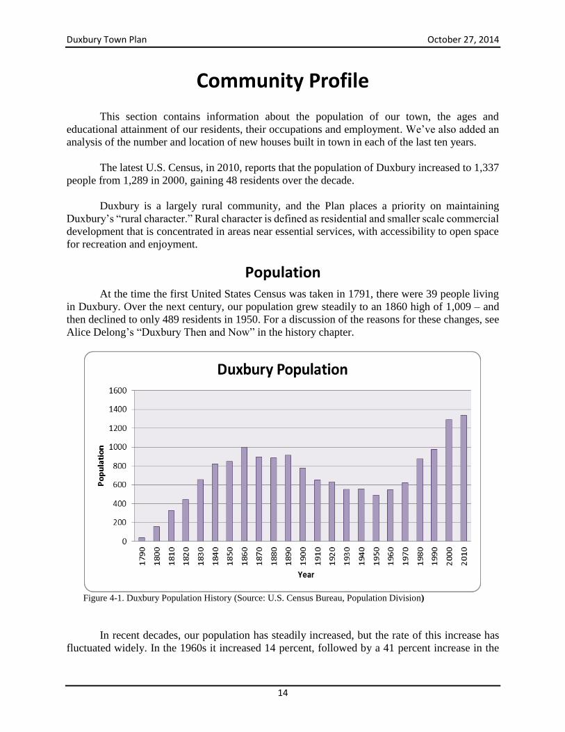
Population At the time the first United States Census was taken in 1791, there were 39 people living
in Duxbury. Over the next century, our population grew steadily to an 1860 high of 1,009 – and
then declined to only 489 residents in 1950. For a discussion of the reasons for these changes, see
Alice Delong’s “Duxbury Then and Now” in the history chapter.
Figure 4-1. Duxbury Population History (Source: U.S. Census Bureau, Population Division)
In recent decades, our population has steadily increased, but the rate of this increase has
fluctuated widely. In the 1960s it increased 14 percent, followed by a 41 percent increase in the
Duxbury Town Plan October 27, 2014
15
1970s, then a more sedate 11 percent in the decade of the 1980s. In the most recent decade, 2000-
2009, our population growth was less dramatic, with an increase to 1,289 residents, giving us a 32
percent growth rate in the decade. According to a study commissioned by the Central Vermont
Regional Planning Commission, by 2020, an estimated 531 people will be added to Duxbury’s
population. This represents an annual projected growth rate of 1.7 percent - the highest in the
Central Vermont Region and more than twice the regional average. Duxbury’s population growth,
which was heavily influenced by natural increase in previous decades, now owes more to in-
migration. This trend is expected to continue in the foreseeable future.1
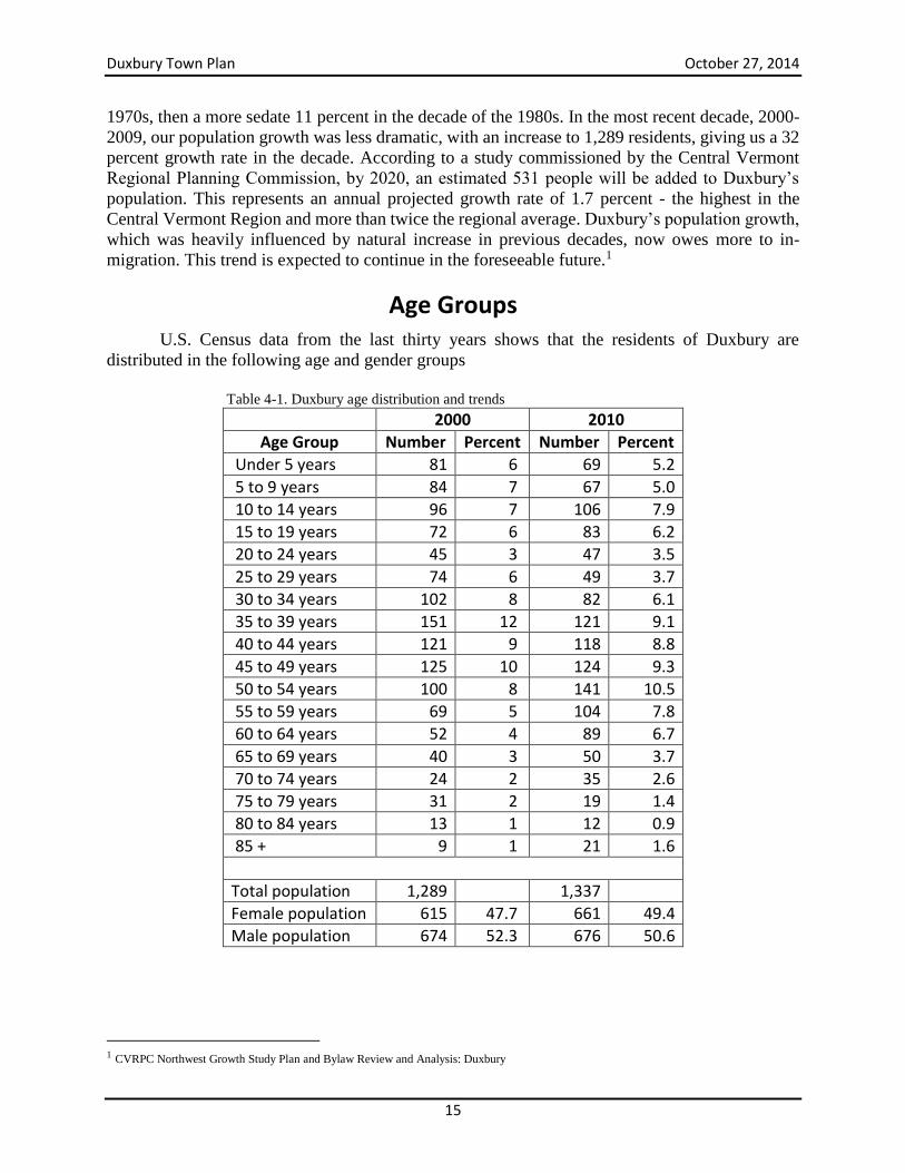
Age Groups U.S. Census data from the last thirty years shows that the residents of Duxbury are
distributed in the following age and gender groups
Table 4-1. Duxbury age distribution and trends
2000 2010
Age Group Number Percent Number Percent
Under 5 years 81 6 69 5.2
5 to 9 years 84 7 67 5.0
10 to 14 years 96 7 106 7.9
15 to 19 years 72 6 83 6.2
20 to 24 years 45 3 47 3.5
25 to 29 years 74 6 49 3.7
30 to 34 years 102 8 82 6.1
35 to 39 years 151 12 121 9.1
40 to 44 years 121 9 118 8.8
45 to 49 years 125 10 124 9.3
50 to 54 years 100 8 141 10.5
55 to 59 years 69 5 104 7.8
60 to 64 years 52 4 89 6.7
65 to 69 years 40 3 50 3.7
70 to 74 years 24 2 35 2.6
75 to 79 years 31 2 19 1.4
80 to 84 years 13 1 12 0.9
85 + 9 1 21 1.6
Total population 1,289 1,337
Female population 615 47.7 661 49.4
Male population 674 52.3 676 50.6
1 CVRPC Northwest Growth Study Plan and Bylaw Review and Analysis: Duxbury
Duxbury Town Plan October 27, 2014
16
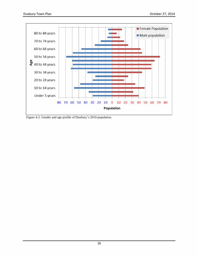
Figure 4-2. Gender and age profile of Duxbury’s 2010 population
Duxbury Town Plan October 27, 2014
17
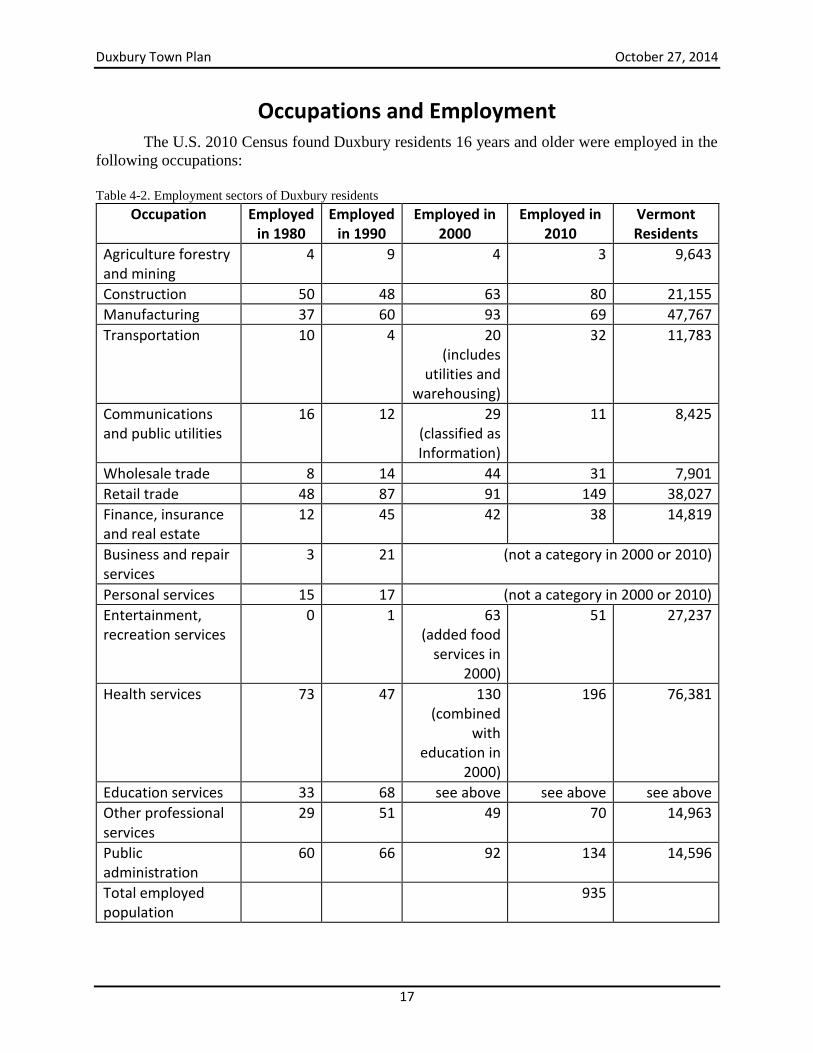
Occupations and Employment
The U.S. 2010 Census found Duxbury residents 16 years and older were employed in the
following occupations:
Table 4-2. Employment sectors of Duxbury residents
Occupation Employed in 1980
Employed in 1990
Employed in 2000
Employed in 2010
Vermont Residents
Agriculture forestry and mining
4 9 4 3 9,643
Construction 50 48 63 80 21,155
Manufacturing 37 60 93 69 47,767
Transportation 10 4 20 (includes
utilities and warehousing)
32 11,783
Communications and public utilities
16 12 29 (classified as Information)
11 8,425
Wholesale trade 8 14 44 31 7,901
Retail trade 48 87 91 149 38,027
Finance, insurance and real estate
12 45 42 38 14,819
Business and repair services
3 21 (not a category in 2000 or 2010)
Personal services 15 17 (not a category in 2000 or 2010)
Entertainment, recreation services
0 1 63 (added food
services in 2000)
51 27,237
Health services 73 47 130 (combined
with education in
2000)
196 76,381
Education services 33 68 see above see above see above
Other professional services
29 51 49 70 14,963
Public administration
60 66 92 134 14,596
Total employed population
935
Duxbury Town Plan October 27, 2014
18
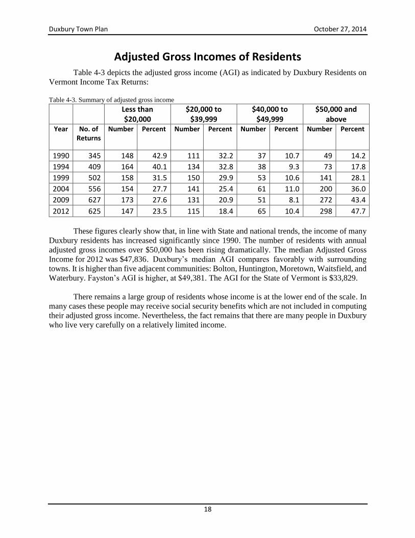
Adjusted Gross Incomes of Residents
Table 4-3 depicts the adjusted gross income (AGI) as indicated by Duxbury Residents on
Vermont Income Tax Returns:
Table 4-3. Summary of adjusted gross income
Less than $20,000
$20,000 to $39,999
$40,000 to $49,999
$50,000 and above
Year No. of Returns
Number Percent Number Percent Number Percent Number Percent
1990 345 148 42.9 111 32.2 37 10.7 49 14.2
1994 409 164 40.1 134 32.8 38 9.3 73 17.8
1999 502 158 31.5 150 29.9 53 10.6 141 28.1
2004 556 154 27.7 141 25.4 61 11.0 200 36.0
2009 627 173 27.6 131 20.9 51 8.1 272 43.4
2012 625 147 23.5 115 18.4 65 10.4 298 47.7
These figures clearly show that, in line with State and national trends, the income of many
Duxbury residents has increased significantly since 1990. The number of residents with annual
adjusted gross incomes over $50,000 has been rising dramatically. The median Adjusted Gross
Income for 2012 was $47,836 . Duxbury’s median AGI compares favorably with surrounding
towns. It is higher than five adjacent communities: Bolton, Huntington, Moretown, Waitsfield, and
Waterbury. Fayston’s AGI is higher, at $49,381. The AGI for the State of Vermont is $33,829.
There remains a large group of residents whose income is at the lower end of the scale. In
many cases these people may receive social security benefits which are not included in computing
their adjusted gross income. Nevertheless, the fact remains that there are many people in Duxbury
who live very carefully on a relatively limited income.
Duxbury Town Plan October 27, 2014
19
Housing
Shelter is a basic human need. The availability, affordability and location of housing within
a community have broad implications for land use. Over the years, Duxbury residents have used a
variety of ways to meet their housing needs. They have converted seasonal camps into year-round
homes, they have moved into partially completed homes while finishing construction, they have
lived in temporary housing while fixing up an old house or while building a new home, and they
have lived with relatives while building on family-owned land. These personal strategies will
undoubtedly continue to be used as the population of Duxbury and housing costs in town continue
to increase.
As housing costs continue to rise the Town and the Planning Commission should explore
mechanisms for fostering appropriate affordable and senior housing within the community. The
goal of encouraging affordable housing without compromising the character of the community or
creating excessive demands on limited infrastructure within a community is especially challenging
for small towns such as Duxbury. Senior housing should be developed in areas where there is good
access to services, which are lacking in Duxbury. The best options for senior housing may be in
Waterbury village. For seniors who prefer to stay in place, improved transportation options to
provide access to services are needed.
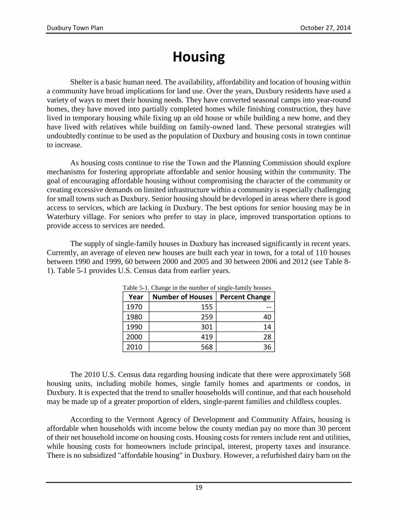
The supply of single-family houses in Duxbury has increased significantly in recent years.
Currently, an average of eleven new houses are built each year in town, for a total of 110 houses
between 1990 and 1999, 60 between 2000 and 2005 and 30 between 2006 and 2012 (see Table 8-
1). Table 5-1 provides U.S. Census data from earlier years.
Table 5-1. Change in the number of single-family houses
Year Number of Houses Percent Change
1970 155 --
1980 259 40
1990 301 14
2000 419 28
2010 568 36
The 2010 U.S. Census data regarding housing indicate that there were approximately 568
housing units, including mobile homes, single family homes and apartments or condos, in
Duxbury. It is expected that the trend to smaller households will continue, and that each household
may be made up of a greater proportion of elders, single-parent families and childless couples.
According to the Vermont Agency of Development and Community Affairs, housing is
affordable when households with income below the county median pay no more than 30 percent
of their net household income on housing costs. Housing costs for renters include rent and utilities,
while housing costs for homeowners include principal, interest, property taxes and insurance.
There is no subsidized "affordable housing" in Duxbury. However, a refurbished dairy barn on the
Duxbury Town Plan October 27, 2014
20
River Road contains several apartments. DuxFarm Estates offers leased lots for modular housing
and the Patterson Trailer Park in Duxbury Corner provides lots for mobile homes. Several mobile
and modular homes are located on individual lots.
Vermont Housing Data show a steady increase in sale price of single family homes over
the town, county and state levels from 2005 to 2012. In contrast, the sale price of mobile homes
with land decreased statewide and increased in Washington County in 2012. No mobile homes
with land were sold in Duxbury in that year.
Table 5-2. Costs of single-family and mobile homes with land sold, by year (Source: Vermont Housing Data)
Single Family Homes Mobile Homes with Land
2005 2012
Percent Change
2005 2012 Percent Change
Duxbury Average
194,395 254,222 31 60,000 n/a n/a
Washington County Average
184,244 205,279 11 78,588 83,474 6
Vermont Average
220,671 236,872 7 84,324 76,753 -9
Duxbury Median
166,250 253,000 52 60,000 n/a n/a
Washington County Median
164,000 190,000 16 69,500 85,000 22
Vermont Median
185,000 203,000 10 75,000 66,250 -12
Vermont Housing Data show an expected increase in home ownership costs from 2000 to
2009. However, the ownerships costs as a percentage of household income decreased in Duxbury,
while increasing at the county and state levels.
Table 5-3. Median monthly owner costs by year (Source: Vermont Housing Data)
With Mortgage Without Mortgage
As Percentage of Household Income
2000-2004
2005-2009
Percent Change
2000-2004
2005-2009
Percent Change
2000-2004
2005-2009
Percent Change
Duxbury 1,013 1,282 27 393 468 19 21.5 20.7 -4
Washington County
1,008 1,413 40 390 587 51 20 22.3 12
Vermont 1,021 1,442 41 378 563 49 20.2 22.9 13
Vermont Housing Data show a significant increase in gross rent paid in Duxbury compared
to county and state levels. This trend holds as well, for gross rent paid as a percentage of household
income.
Duxbury Town Plan October 27, 2014
21
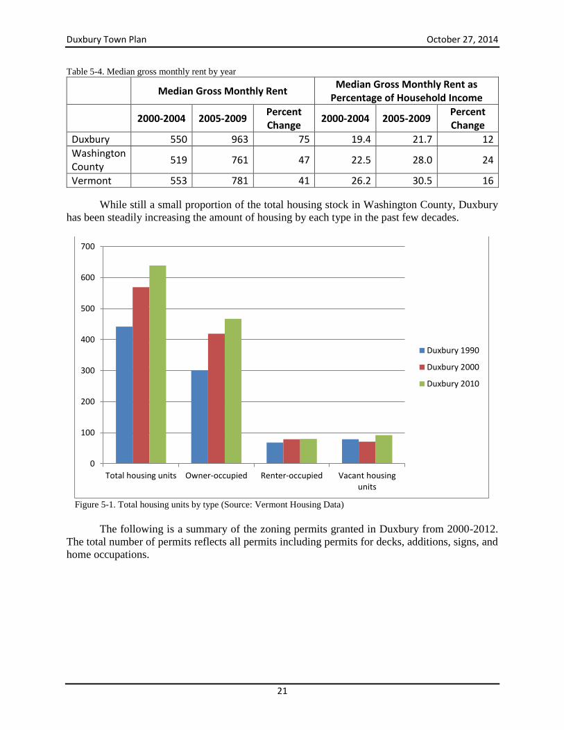
Table 5-4. Median gross monthly rent by year
Median Gross Monthly Rent
Median Gross Monthly Rent as Percentage of Household Income
2000-2004 2005-2009
Percent Change
2000-2004 2005-2009 Percent Change
Duxbury 550 963 75 19.4 21.7 12
Washington County
519 761 47 22.5 28.0 24
Vermont 553 781 41 26.2 30.5 16
While still a small proportion of the total housing stock in Washington County, Duxbury
has been steadily increasing the amount of housing by each type in the past few decades.
Figure 5-1. Total housing units by type (Source: Vermont Housing Data)
The following is a summary of the zoning permits granted in Duxbury from 2000-2012.
The total number of permits reflects all permits including permits for decks, additions, signs, and
home occupations.
0
100
200
300
400
500
600
700
Total housing units Owner-occupied Renter-occupied Vacant housingunits
Duxbury 1990
Duxbury 2000
Duxbury 2010
Duxbury Town Plan October 27, 2014
22
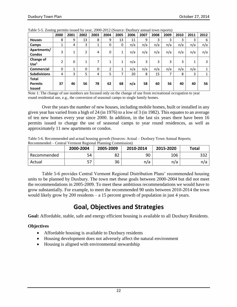
Table 5-5. Zoning permits issued by year, 2000-2012 (Source: Duxbury annual town reports)
2000 2001 2002 2003 2004 2005 2006 2007 2008 2009 2010 2011 2012
Houses 8 9 13 8 9 13 11 9 3 3 3 3 6
Camps 1 4 3 1 0 0 n/a n/a n/a n/a n/a n/a n/a
Apartments/ Condos
3 1 2 4 0 1 n/a n/a n/a n/a n/a n/a n/a
Change of Use1
2 0 1 7 1 1 n/a 3 3 3 3 1 3
Commercial 0 1 0 0 2 1 n/a n/a n/a n/a n/a n/a 1
Subdivisions 4 3 5 4 5 7 20 8 15 7 8 3 1
Total Permits Issued
37 46 56 78 62 68 n/a 58 60 56 40 40 56
Note 1: The change of use numbers are focused only on the change of use from recreational occupation to year
round residential use, e.g., the conversion of seasonal camps to single family homes.
Over the years the number of new houses, including mobile homes, built or installed in any
given year has varied from a high of 24 (in 1976) to a low of 3 (in 1982). This equates to an average
of ten new homes every year since 2000. In addition, in the last six years there have been 16
permits issued to change the use of seasonal camps to year round residences, as well as
approximately 11 new apartments or condos.
Table 5-6. Recommended and actual housing growth (Sources: Actual – Duxbury Town Annual Reports;
Recommended – Central Vermont Regional Planning Commission)
2000-2004 2005-2009 2010-2014 2015-2020 Total
Recommended 54 82 90 106 332
Actual 57 36 n/a n/a n/a
Table 5-6 provides Central Vermont Regional Distribution Plans’ recommended housing
units to be planned by Duxbury. The town met these goals between 2000-2004 but did not meet
the recommendations in 2005-2009. To meet these ambitious recommendations we would have to
grow substantially. For example, to meet the recommended 90 units between 2010-2014 the town
would likely grow by 200 residents – a 15 percent growth of population in just 4 years.
Goal, Objectives and Strategies Goal: Affordable, stable, safe and energy efficient housing is available to all Duxbury Residents.
Objectives
Affordable housing is available to Duxbury residents
Housing development does not adversely affect the natural environment
Housing is aligned with environmental stewardship
Duxbury Town Plan October 27, 2014
23
Strategies
Appropriately, the zoning in Duxbury contains no prohibitions against any form of affordable
housing in any district. Strategies that will expand affordable housing in our community are:
Identify where future projected housing would ideally be sited based on CVRPC housing
projections.
Determine possible locations for affordable housing.
Review and amend the zoning ordinance as necessary to ensure new housing is safe,
located conveniently to employment and commercial centers, and has access to necessary
public infrastructure and utilities.
Develop regulations that require 25 percent of any development of 4 or more housing
units be affordable and provide density and coverage bonuses for developments exceeding
25 percent affordable units.
Develop a regulation that requires 40 percent of all residential units be affordable within
the State Farm Barn/Buildings Sub-Area.
Review regulations, and amend as necessary, to allow multi-family housing to be sited in
areas zoned for single-family dwellings.
Investigate grant and loan programs available through the Vermont Housing and
Conservation Board, Central Vermont Community Land Trust and other organizations
that can be used to renovate existing rental housing and develop new housing, including
senior housing.
Complete a detailed build-out analysis of how increasing density in the village district
and other changes could reduce the amount of scattered development and increase the
amount of housing units in the village.
Duxbury Town Plan October 27, 2014
24
Natural Resources
Duxbury’s diverse and abundant natural resources significantly contribute to the town’s
rural character, local economy, ecological health and scenic beauty.
Duxbury’s large areas of undeveloped forests serve as a critical and irreplaceable
cornerstone of the Green Mountains, providing a direct link between the northern mountains of
Bolton, Stowe and Underhill, the southern mountains of Warren, Fayston and Lincoln, and the
Northfield and Worcester Ranges to the east, via forested linkages with Moretown. Duxbury’s
forests, fields and waterways are host to a wide range of biological diversity, including an array of
mammals, birds, insects, reptiles, fish and plants.
With over 40,000 visitors annually to Camels Hump State Park, and with Duxbury’s
forested hills a primary vista, Duxbury’s natural resources are significant to the local and regional
economy. Most Duxbury residents enjoy some form of recreation in the large expanse of forested
lands; many derive an income from these forests.
Because of the significance of the town’s natural resources, coupled with the rapid growth
of subdivisions and housing developments (particularly in heavily forested and remote areas), there
is an urgency to ensuring the appropriateness of future land development. Such development must
be sensitive to, and in accordance with, the multiple social, economic and ecological values
inherent in the town’s natural resources.
This section of the Town Plan describes in detail Duxbury’s geography and natural
resources, and encourages ways to protect these resources. The Land Use Plan that follows is based
on the findings in this section.
Geography
The town of Duxbury is located directly east of the principal ridge of the Green Mountains
and immediately south of the Winooski River. The towns of Moretown, Waitsfield and Fayston
border Duxbury to the east and south; Huntington lies to the west, as does a portion of Bolton.
Waterbury, along with the remainder of Bolton, forms the northern border of Duxbury. Duxbury
is located at the western edge of Washington County.
In many respects, Duxbury enjoys a convenient location in central Vermont. The town is
approximately 15 miles northwest of the state capital in Montpelier and about 25 miles southeast
of Burlington, the state’s largest population center. Major ski areas are located in Fayston and
Warren, a few miles to the south, and in Stowe and Bolton, a few miles to the north and west.
However, Duxbury’s central location is misleading. Hills and mountains are so numerous
that only one paved highway transects the town, Route 100 running north and south near the town’s
eastern boundary. Furthermore, although Vermont’s major east-west highway, Interstate 89, runs
through the Winooski Valley, it is separated from Duxbury by the Winooski River. Access is
Duxbury Town Plan October 27, 2014
25
limited to just two bridges, located at the northeast section of town. Thus, the apparent advantages
of Duxbury’s central location are largely offset by its rugged terrain and consequent lack of
convenient traffic corridors.
The historic settlement pattern of non-native settlers occurred along the valley and river
shores of Duxbury, with compact settlements in a few locations (e.g. Duxbury Corners). Gradually
settlers moved to higher locations, following stream beds up the hills. The infrastructure and layout
of roads, and consequently of houses and buildings, has changed little since the 1800s. However,
as housing pressures increase, more and more houses are now being built at higher elevations, and
in more remote areas. This Plan, therefore, strongly recommends that the existing road
infrastructure be used for future development at these higher elevations, rather than resorting to
the construction of new roads, except in those cases where there are clear and compelling
ecological benefits to doing otherwise.
Topography
Duxbury is dominated by mountain ridges on three sides, forming a giant U-shape, the
open end of which is formed by the Winooski Valley to the north. Mountains run from the town’s
northwest corner along its western boundary, turn broadly in an easterly direction along the town’s
southern boundary, and then proceed back to the Winooski valley. This broadly curving ridgeline
determines the formation of drainage basins throughout the town.
Ridley Brook drains the northwestern portion of the town, flowing virtually due north into
the Winooski River. Crossett and Dowsville Brooks form the principal drainages in the eastern
section of town. A small area in the southwestern portion of Duxbury is drained by Shepard Brook.
Physical relief in the town of Duxbury is one of the most extreme in all of Vermont.
Elevations range from about 360 feet above sea level along the Winooski River to 4083 feet at the
summit of Camels Hump only four- and- a- half miles away. These elevations are the lowest and
highest, respectively, in the central Vermont region. Duxbury also has the greatest amount of land
within the region above 2500 feet in elevation. We also have a large amount of land above 1500
feet, the threshold at which the town strongly discourages any new housing development. Our
town-wide physical relief, coupled with localized variations in elevation, results in a large
percentage of land with slopes of more than 15 percent. A map of such slopes is available at the
Town Clerk’s Office.
Relatively flat land is confined to narrow strips along the Winooski River, much of it within
the river’s floodplain, and to scattered areas along Route 100. Additionally, small areas of flat land
are scattered throughout the town on benchtops, small plateaus and along streams.
Because of the abundance of slopes over 15 percent, the large amount of land at higher
elevation, and the percentage of flat land in floodplain, much of the town of Duxbury must be
considered to offer only limited opportunities for development.
Also, because the topography is dominated by two roughly parallel ridges running
northerly and northeasterly, the town of Duxbury is uniquely placed as a linkage for wildlife
migrating along the spine of the Green Mountains, and from the Green Mountains to the Northfield
Duxbury Town Plan October 27, 2014
26
and Worcester Ranges to the east. For that reason, special efforts should be made to maintain and,
when possible, enhance known wildlife travel corridors.
Water Resources
Rivers and Streams
Duxbury’s northern boundary is defined by approximately seven miles of the Winooski
River. Ridley Brook and Crossett Brook flow into the Winooski River, and their watersheds cover
the drainage for the northern portion of town. Welder Brook, Dowsville Brook and Shepard Brook
watersheds are catchments for the southern section of the town, and they flow into the Mad River,
which also flows in to the Winooski River. All of our watersheds are part of the larger Lake
Champlain Basin.
The Winooski River is classified in the Vermont Water Quality standards as a Class B
water, “suitable for recreational boating, irrigation of crops, habitat for wildlife and for common
food and game fishes.” With the exception of the area immediately adjacent to the Bolton Falls
hydroelectric dam, the Duxbury section of the Winooski River is undeveloped; part of the only
section of the river to be designated as an “undeveloped corridor” by the Vermont Rivers Study
(Vermont DEC, 1986). Although the riverine corridor has lost most of its floodplain forest to
agricultural uses, vestiges of this natural community type are found near the Bolton Falls dam and
along the river near the Duxbury/Bolton town line. The riverine corridor provides important habitat
for mammals including fox, otter, mink, beaver, deer and moose; for waterfowl, especially
common merganser; for migratory songbirds; and for predatory birds such as osprey, buteos and
migrating eagles. The river supports brown and rainbow trout, as well as smallmouth bass. Due to
annual stocking by the Vermont Department of Fish and Wildlife, the Duxbury section of the river
has become a fishery of state significance. As the water quality of the river has improved, the river
has also become more popular for canoeing and kayaking. Water quality monitoring for bacteria
should be conducted before direct contact recreation (i.e. swimming) is encouraged.
Our five major brooks have also been designated as Class B waters, suitable for swimming
and recreation, irrigation, agricultural uses, and fish habitat, primarily for brook trout. They are
acceptable for public water supply with filtration and disinfection. Their biological condition is
good to excellent, as would be expected for cold water streams in a forested watershed. The brooks
are highly valued by townspeople for their recreational, aesthetic, and wildlife attributes. Except
for a small hydroelectric dam on Crossett Brook, the brooks are free-flowing; historically most of
the streams provided power for saw mills, making them the center of early settlements. Following
settlement patterns, many town roads run parallel to the brooks. Most of our brooks are in pristine
condition above the settled portions of town. Exceptions to this are erosion problems from logging
roads and snowmobile trails that cross the streams over culverts.
Threats to water quality and aquatic habitat include erosion from road run-off, construction
activities and logging; pollution from failing septic systems and domestic animal waste; and
removal of streamside and riparian vegetation. To reduce these threats, adequate riparian buffers
need to be maintained; and when development is proposed near riparian zones, detailed site plans
with appropriate design standards need to be utilized. Throughout the town, the natural condition
of the riparian area is forested. With a forested canopy, the streams will stay cooler in the summer,
Duxbury Town Plan October 27, 2014
27
will be less susceptible to streambank erosion, and will retain their natural biological condition.
As with the Winooski River, a naturally-maintained riparian area is also important wildlife habitat
and a corridor for wildlife movement. It is far more cost effective to maintain the high water quality
and aquatic habitat that we have now, than to restore degraded streams. Therefore, the town
discourages development activities along riparian corridors. The town encourages adequate set-
backs for structures and septic systems; recommends a 100 foot buffer zone along principal
streams; and also encourages naturally forested streambanks. This is especially important in the
absence of a septic ordinance.
Floodplains Floodplains in Duxbury are limited to lands bordering the Winooski
River on the north side of the North Duxbury Road and lands bordering the lower portion of
Crossett Brook from Route 100 to the Winooski River. By maintaining these floodplains, we can
ensure that periodic flooding can occur without destruction to property and without disruption of
the natural processes of river channel stabilization. Federal Flood Insurance maps showing the
boundaries of the federally-designated flood hazard areas are available in the Town Clerk’s office.
The Town has adopted standards in its zoning ordinance to regulate building in these designated
flood hazard areas.
Wetlands Wetlands are those areas that are sufficiently saturated or flooded during the growing
season to support water loving (hyrophilic) plants, to allow for the development of hydric soils,
and to support aquatic life that is dependent on flooded, saturated or seasonally saturated soil
conditions. Wetlands include marshes, forested and shrub swamps, bogs, fens, vegetated river
channels, lake shores, ponds and pond shores, and vernal pools.
Duxbury’s topography has limited the extensive development of wetlands. A review of the
Vermont Significant Wetland Inventory Map for the town indicates that most of the wetlands are
riverine channel wetlands, associated with the Winooski River or one of the brooks, and ponds.
Several of our most important ponds are beaver-impounded wetlands at the headwaters of
Dowsville Brook and Ridley Brook, such as Beaver Meadow. Other important beaver-influenced
wetlands parallel route 100 along unnamed tributaries northerly to Crossett Brook, and southerly
to Dowsville Brook. These wetlands contain areas of emergent marsh, shrub swamp and forested
swamp. Wetland types that have not been inventoried in town are vernal pools and forested seeps.
Both of these wetland types are very small, but contribute to the biological integrity of the forest
ecosystem. Vernal pools provide breeding habitat for amphibian species, such as wood frogs and
spotted salamanders, whose life cycle depends on these temporary pools. Woodland seeps are areas
of groundwater discharge which support the base flow of headwater streams.
Wetlands are important natural communities not only to wetland-dependent wildlife and
plants but also to the general public for the functions and values they provide. These functions and
values include: temporary storage of floodwater and stormwater runoff; surface and groundwater
protection; erosion control through binding and stabilizing the soil; fisheries habitat; wildlife
habitat, including habitat for migratory birds; rare natural community types; habitat for rare,
threatened and endangered species; opportunities for education and research; opportunities for
Duxbury Town Plan October 27, 2014
28
recreation and outdoor activities; and finally the aesthetic value of open space in the landscape.
The functions and values of any particular wetland depend a great deal on its landscape setting,
and of course, not all wetlands provide all of these functions; wetlands shown on the Vermont
Significant Wetland Inventory map are presumed to be significant for one or more functions.
The residents of Duxbury have indicated that water quality and wildlife habitats are
important components of our natural environment. We can help maintain these resources by
providing sufficient wetland and riparian buffers, as for our river and stream corridors. Therefore,
we encourage adequate setbacks for significant wetlands and discourage building, vegetation
clearing and earth disturbance within wetland buffers.
Groundwater The vast majority of townspeople depend upon groundwater from springs and deep
bedrock wells. There are also a few small aquifers (gravel and sand deposits in valley areas that
store groundwater) that provide water for residential use. No significant aquifers have been
identified that would support large scale commercial or industrial development.
The protection of groundwater is essential. In order to ensure the protection of
groundwater, it is recommended that source protection areas be identified, that adequate setbacks
from well heads be maintained, and that the town adopt rules for the siting, construction and
maintenance of septic systems.
Vermont state statute requires that municipalities who choose to undertake planning to
develop plans and associated implementation measures that conform to certain statutory planning
and development goals. These include: “To identify, protect and preserve important natural and
historic features of the Vermont landscape, including… outstanding water resources, including
lakes, rivers, aquifers, shorelands and wetlands;” and “To maintain and improve the quality of air,
water, wildlife and land resources.” Groundwater is a part of the water resources addressed by
these goals.
In most communities, groundwater has been included as a part of these goals by various
mechanisms. Often, these planning goals have been applied to groundwater and addressed by
adopting municipal plan policies calling for the protection of groundwater from contamination
from inappropriate land uses (e.g., such as failed or poorly designed septic systems, waste disposal,
and leaking fuel tanks). Such policies are commonly implemented through zoning bylaws that
establish standards for development within identified groundwater source protection areas (as
noted previously, there are several good resources available to assist communities to plan for
groundwater protection from contamination).
Another way to protect local groundwater resources is to regulate groundwater extraction.
As of 2008, groundwater is a public trust resource that must be managed by the state in the best
interest of all Vermonters. Act 199 of 2008 gives towns additional tools to manage groundwater
in their communities. Under Act 199, the Agency of Natural Resources may only issue a permit
for new or increased groundwater withdrawal if the secretary determines – among other factors –
that the proposed withdrawal is “consistent with the town or regional plan in which [it] is located,”
and with any policies managing groundwater as a public trust resource. This is the first update to
Duxbury Town Plan October 27, 2014
29
Duxbury’s town plan since Act 199 was passed, hence the inclusion of this new section in our
town plan.
Duxbury values groundwater as a vital resource that must be protected from degradation
to:
Protect the primary source of potable water for our current residents
Protect the ecological functions of wetlands
Ensure adequate streamflow, especially base flow during drought
Maintain potable water supplies for future generations
Avoid potentially adverse secondary impacts associated with the development of
groundwater resources (e.g. noise, trucking)
Groundwater is particularly important to Duxbury’s natural resources due to the connection
between surface water and groundwater for headwater wetlands, vernal pools and in the high
elevation residential and natural communities of Camels Hump, Crossett Hill and Ward Hill.
Protecting groundwater in these areas will protect the wetland resources, stream resources
(especially base flow) and the forest resources that rely on groundwater for health of these natural
systems.
Additionally, there are two active source protection areas for public or community water
supplies in Duxbury located along or near Route 100. These can be viewed on ANR Natural
Resource Atlas (tinyurl.com/vt-atlas). This atlas shows the source protection areas for Public
Community and Non-transient, Non-Community water systems. It also differentiates between the
groundwater systems and the surface water systems.
In the Ecological Reserve, Timber Management and Wildlife, Forest-Recreational, Rural-
Agricultural I, Rural-Agricultural II, Village and State Farm Districts, in Duxbury, groundwater is
particularly important to protect because the fundamental uses of these districts all rely on a clean,
abundant source of groundwater.
As productive land becomes less economically viable to manage solely for agriculture and
forestry, other financial incentives need to be available for landowner to maintain large tracts of
undeveloped land. Commercial water extraction may provide such an incentive. Commercial
groundwater extraction could provide benefits to the town, including the potential for maintaining
large tracts of undeveloped open space.
That said, the commercial extraction of groundwater is of increasing concern to
communities across Vermont. Truck traffic and impacts to surrounding water sources (e.g.
residential wells) are important considerations. The impact of groundwater extraction on
neighboring water supplies, and on the public interest of protecting natural resource and ensuring
that an adequate supply of water remains in the community, are also important issues. Prior to any
large-scale withdrawal, safeguards to ensure that neighboring waters supplies will not be adversely
affected should be established and the issues associated with the impacts of privatization of a basic
life resource and the transport of that resource out of the watershed must be addressed.
In 1982, an Act 250 application was filed for a bottled water facility for Duxbury VT
Springs (5W0651). In 1995, an application for that project was filed to increase withdrawals from
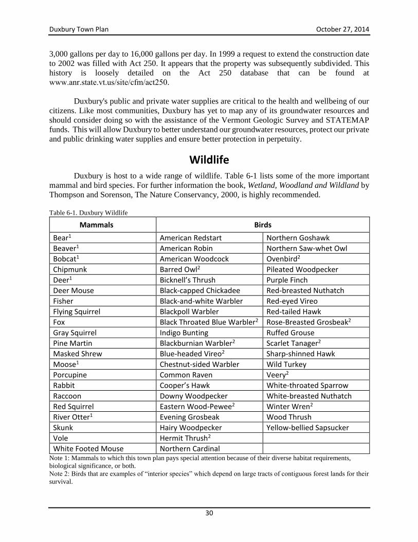
Duxbury Town Plan October 27, 2014
30
3,000 gallons per day to 16,000 gallons per day. In 1999 a request to extend the construction date
to 2002 was filled with Act 250. It appears that the property was subsequently subdivided. This
history is loosely detailed on the Act 250 database that can be found at
www.anr.state.vt.us/site/cfm/act250.
Duxbury's public and private water supplies are critical to the health and wellbeing of our
citizens. Like most communities, Duxbury has yet to map any of its groundwater resources and
should consider doing so with the assistance of the Vermont Geologic Survey and STATEMAP
funds. This will allow Duxbury to better understand our groundwater resources, protect our private
and public drinking water supplies and ensure better protection in perpetuity.
Wildlife
Duxbury is host to a wide range of wildlife. Table 6-1 lists some of the more important
mammal and bird species. For further information the book, Wetland, Woodland and Wildland by
Thompson and Sorenson, The Nature Conservancy, 2000, is highly recommended.
Table 6-1. Duxbury Wildlife
Mammals Birds
Bear1 American Redstart Northern Goshawk
Beaver1 American Robin Northern Saw-whet Owl
Bobcat1 American Woodcock Ovenbird2
Chipmunk Barred Owl2 Pileated Woodpecker
Deer1 Bicknell’s Thrush Purple Finch
Deer Mouse Black-capped Chickadee Red-breasted Nuthatch
Fisher Black-and-white Warbler Red-eyed Vireo
Flying Squirrel Blackpoll Warbler Red-tailed Hawk
Fox Black Throated Blue Warbler2 Rose-Breasted Grosbeak2
Gray Squirrel Indigo Bunting Ruffed Grouse
Pine Martin Blackburnian Warbler2 Scarlet Tanager2
Masked Shrew Blue-headed Vireo2 Sharp-shinned Hawk
Moose1 Chestnut-sided Warbler Wild Turkey
Porcupine Common Raven Veery2
Rabbit Cooper’s Hawk White-throated Sparrow
Raccoon Downy Woodpecker White-breasted Nuthatch
Red Squirrel Eastern Wood-Pewee2 Winter Wren2
River Otter1 Evening Grosbeak Wood Thrush
Skunk Hairy Woodpecker Yellow-bellied Sapsucker
Vole Hermit Thrush2
White Footed Mouse Northern Cardinal Note 1: Mammals to which this town plan pays special attention because of their diverse habitat requirements,
biological significance, or both.
Note 2: Birds that are examples of “interior species” which depend on large tracts of contiguous forest lands for their
survival.
Duxbury Town Plan October 27, 2014
31
Mammals of Special Interest
Because of their unique habitat requirements, certain species can be more difficult to
protect than others. The Town Plan identifies moose, bobcat, bear, river otter, beaver and deer as
six species of interest. The protection of these species within Duxbury is both a challenge and an
opportunity. Pressures such as housing, logging, road building, air pollution and tree diseases are
increasingly threatening the habitats of these species. However, the vast amount of undisturbed
forest cover, and the diversity of Duxbury’s natural resources presents an unusual opportunity to
plan for the long-term protection of these species, even in the face of increasing pressures.
Black Bear
The black bear, ranging in size from 200 to 500 pounds, resides throughout many areas in
Duxbury. The black bear, with a range of at least a 10-mile radius, requires a variety of habitat
types, including deep, contiguous woods (particularly forests with beech and butternut stands),
mature forests with large down and standing trees, old fields and early successional forests with
berries and nut-producing shrubs, as well as wetlands. They feed on grasses, berries, fruits, seeds,
nuts, bark, roots, insects, honey, fish, frogs, rodents, birds and carrion. Any areas within Duxbury
that contain large stands of mature beech can be considered an important habitat area for bears.
Healthy stands of beech are becoming increasingly rare, not only in Duxbury but statewide, as a
result of the disease “scale nectria.” Some examples of mature, intact beech stands include sections
of Camels Hump State Park, unlogged sections of Ward Hill, especially at higher elevations, and
sections of Crossett Hill on the North Duxbury Side. Healthy stands of young beech trees, even
those that do not show current bear activity, should also be considered an important future resource
for bear habitat.
Significant wetland areas with known bear activity include the three wetlands in the
southeast corner of Duxbury east of Route 100. This area is an important seasonal feeding and
migration area between the Green Mountains and the Northfield and Worcester Ranges, providing
the only forested and relatively undeveloped link between these ranges north of Granville. It is
urged that landowners in this area be approached to see what steps might be taken to protect this
vital habitat. Beaver Meadow, lying between the drainages of Ridley and Dowsville Brooks, is
also a significant wetland for bear activity.
River Otter
The river otter, ranging from 35 to 55” in length, is a resident of the Winooski River,
including sections along River Road in Duxbury. River otter feed on fish, crayfish, frogs,
salamanders, snails, snakes and turtles. They depend upon undeveloped woodlands along the
Winooski River for their den and feeding needs.
Beaver
The beaver, the largest rodent in the United States, ranges in size from 34 to 43” long.
Beavers feed on the bark, twigs, and wood of deciduous trees, particularly poplar, cottonwoods
and willows. In Duxbury, beaver are present both at low altitudes, including along the Winooski
River, and at high altitudes, notably wetland areas such as Beaver Meadows and areas along
Crossett Brook and the Winooski River. Beavers play a unique role in creating and maintaining a
biologically diverse wetland ecosystem.
Moose
A large moose can stand as high as 6 feet at shoulder height, and can weigh up to 1800
pounds. Moose feed on the twigs, leaves and bark of a variety of deciduous and coniferous trees,
Duxbury Town Plan October 27, 2014
32
as well as on water lilies and the roots of aquatic plants. They depend on wetland areas, but also
rely on upland forested areas during some parts of the year. The moose population in Vermont is
recovering from near extirpation during the mid-1900s. Much of Duxbury can be considered
moose habitat; however certain areas have greater significance. Bamforth Ridge, the ridge of
Crossett Hill and associated spurs (particularly in the North Duxbury area), the ridge leading to
Mount Ethan Allen and Mount Ira Allen are all important winter areas for moose. Important
wetland areas include the southeast corner of Duxbury east of Route 100, as well as Beaver
Meadows. There are also documented moose travel corridors in two locations: 1) from high
elevations to the Winooski River (and presumably on to Bolton) along River Road, between
Camels Hump Road to the east and the Duxbury town line to the west; and 2) from the Green
Mountain range to the Northfield Range along sections of Route 100 between the southern
entrance of Turner Hill and Ryan Road. The section of Bolton directly adjacent to the River Road
crossing is one of the prime moose sighting areas in Duxbury.
Deer
Deer are abundant in Duxbury. The Department of Fish and Wildlife has identified seven
deeryards in Duxbury as critical wildlife habitat. These deer wintering areas are characterized by
softwood stands, favorable slopes, moderate elevation and low levels of human disturbance in
winter. These deeryards are identified on the Natural Resources Map (Map 1). Every effort should
be made to mitigate possible adverse impacts of proposed development. Where such development
may adversely impact deeryards, the findings and mitigation measures offered by State wildlife
specialists should serve as guidelines for allowing or denying land use permits.
Bobcat
Bobcats can range between 25 and 30” in length, and weigh 25 to 30 pounds. They feed on
insects, rodents, birds, small mammals and occasionally on weak and very young deer. They
remain active in winter. Their range can be as large as 4 to 5 square miles, depending on the food
resources available. Important habitat areas include rocky ledges and outcroppings, and areas with
large den trees and root cavities. Bobcats are present in Duxbury; one area with known activity is
the northwestern section of town between the Winooski River to the north, the Bolton Dam to the
east, up to the Bamforth Ridge to the south, extending throughout the southern section of Bolton.
In particular, Bobcat are known to occur along the rocky outcrop areas in that region. This area is
currently in both state ownership at higher elevations, and in private ownership at lower elevations.
Every effort should be made to approach landowners to see what steps might be taken to protect
this vital habitat.
Importance of contiguous forest lands and connectivity between habitats
From the air, most of Duxbury seems to be cloaked in forest cover, with a few exceptions
to the northwest and along Route 100. However, this view is deceptive. Several scientific studies
have shown that even small openings in a forest, such as a road or house clearing, can affect
sensitive “interior species” such as the birds noted above. One threat to nesting birds is the brown-
headed cowbird which may penetrate the forest as far as 500 feet from a clearing in order to lay its
eggs in a songbird’s nest. Obviously, the cumulative effect of many small clearings and road
networks will compound these problems, and large contiguous tracts of forest land will remain a
vital and increasingly rare habitat requirement, and forest fragmentation an increasing threat.
In addition to contiguous forest cover, some larger ranging mammals, such as bear and
moose, require a variety of ecosystem types over broader distances. One of the most important
Duxbury Town Plan October 27, 2014
33
habitat needs for these species is connectivity between different types of habitats, such as upland
forests, wetlands, and rivers. Large ranging mammals require connected habitat in order to migrate
and to cover large areas to find food and to breed. Housing developments, large scale intensive
logging and roads can all create impediments for these types of mammals. For that reason, the
Town Plan places special importance on known animal corridors that cross roads. Two that have
been identified are the northwest corner of Duxbury along River Road, and the southern section of
Route 100 between the southern entrance of Turner Hill and Ryan Road. These two areas have
wildlife significance not only to Duxbury, but to the wider natural landscape of central Vermont.
Biodiversity hotspots and sites of high conservation value
There are two areas in Duxbury identified by the Vermont Biodiversity Gap Project (a
project of The Nature Conservancy, the State of Vermont and the University of Vermont) as
“Biodiversity hotspots.” These areas are identified by a combination of factors, including the
occurrence of rare, endangered and/or threatened species and their habitats, as well as specific sites
of ecological interest, including areas such as talus slopes, rich fens, and unusual wetland areas.
The major area identified as a biodiversity hotspot, which is noted on the natural resources map,
is the area of northwest Duxbury, extending from approximately the border of Duxbury and Bolton
from the west, to the Bolton Dam to the east, and from the Winooski River to the north, up to and
including the rocky outcrops to the south toward Bamforth Ridge. This area is also considered an
area of high conservation value, given its habitat features. An additional area of high conservation
value is the area east of Route 100 between the southern entrance of Turner Hill and Ryan Road.
Areas of high conservation value are areas that provide critical habitat for the key species included
in this plan. Additional areas of high conservation value may be identified by the town.
Forest Land
Duxbury has the distinction of having the greatest altitudinal gradient of any town in
Vermont. As a result, the town contains an array of natural communities and associated biological
diversity. In particular, Duxbury contains three broad types of forest communities. These are
Spruce-Fir Northern Hardwoods, Northern Hardwoods, and Riverine Floodplain Forest. Each of
these is described below.
Higher elevation forests (>2200 feet): Spruce-Fir Northern Hardwood Forests
At higher elevations, spruce-fir northern hardwood forest communities dominate. Specific
variants include 1) subalpine krummholz at the highest elevation (low, dense thickets of balsam
fir and black spruce); 2) montane and lowland spruce-fir forests between 2200 and 3000 feet
(forests of red spruce, balsam fir, with paper and yellow birch), and 3) transition forests of red
spruce and northern hardwoods (spruce, yellow birch, sugar maple, beech, balsam fir, white ash
and other species).
Associated species of these communities include: black-eyed junco, white-throated
sparrow, blackpoll warbler, ruby-crowned kinglet, boreal chickadee (rare species) and Bicknell’s
thrush, a rare migratory songbird that breeds in only a handful of sites across New England.
Mammals at these higher elevations include porcupines, red squirrels, flying squirrels, and moose.
Understory plants that characterize these forests include wood sorrel, bunchberry, shining
clubmoss and mountain wood fern.
Duxbury Town Plan October 27, 2014
34
Endangered species in Duxbury at these higher elevations include: Bearberry willow (Salix
uva-ursi), and Boott’s Rattlesnake-root (Prenanthes boottii). Rare plant species include mountain
sandwort (Minuartia groenlandica), bigelow’s sedge (Carex bigelowii), fragrant fern (Dryopteris
fragrans), black crowberry (Empetrum nigrum), alpine sweetgrass (Hierochloe alpina), highland
rush (Juncus trifidus), alpine knotweed (Polygonum viviparum), and mountain cranberry
(Vaccinium vitis-idaea).
Forests of these types are found along Duxbury’s higher ridges, including Bamforth Ridge,
areas of Crossett Hill, Ward Hill, Camels Hump, and the ridge leading to Mount Ethan Allen and
Mount Ira Allen. In fact, Duxbury contains one of the largest, undisturbed areas of montane spruce-
fir forests in Vermont.
Mid-level elevations (<2700 feet): Northern Hardwoods
Northern hardwood forests is the dominant forest type of Duxbury, and indeed of Vermont.
Three variants of this forest type are found in Duxbury. The first, rich northern hardwood forests,
are found in pockets along the north westerly and eastern slopes of Crossett Hill. These forests are
characterized by rich soils and high ecological productivity. Understory plants that characterize
this forest type include maidenhair fern, blue cohosh, wood nettle, dwarf ginseng, spring beauties,
and wild leeks. The second is beech-red maple-hemlock northern hardwoods, where beech and red
maple dominate the forest canopy. These forests, found at higher elevations along Ward Hill, by
Beaver Meadows, and along the ridge of Crossett Hill, are primary bear habitat sites. The third
type is sugar maple-white ash-jack in the pulpit northern hardwoods. These forests, found
throughout Duxbury, are characterized by the dominance of white ash, and the presence of Jack-
in-the-pulpit, yellow violet, lady fern and wild oats in the understory.
Associated bird species found in large undisturbed areas of the northern hardwoods in Duxbury
include hermit thrush, rose-breasted grosbeak, ovenbird, red-eyed vireo, eastern wood peewee,
black-throated blue warbler, veery, pileated woodpecker, and scarlet tanager. Common understory
plants include painted and red trillium, wild oats, trout lily, false solomon’s seal, Indian cucumber
root, Indian pipe, wood sorrel, hay scented fern, Christmas fern and sarsaparilla. Mammals in this
forest type include black bear, moose, white-tailed deer, fisher, martin, bobcat, red and flying
squirrels, porcupine, beaver, masked shrew, chipmunk and wood mouse. Invertebrates include red
eft, spotted salamander, wood frog, red-backed salamander, and northern red-belly snakes.
Duxbury Town Plan October 27, 2014
35
Low elevation (<400 feet): Riverine Floodplain Forest
Along the Winooski River, the dominant forest type shifts to a silver maple-ostrich fern
riverine floodplain forest. This forest type has been greatly reduced throughout all of its range in
Vermont, as a result of agriculture and development. The State of Vermont estimates that less than
5% of the original extent of this forest type remains. These forests, which are normally flooded
annually, include silver maple, cottonwood, American elm, hackberry, and boxelder. Shrubs
include riverbank grapevine and wild cucumber. Ostrich ferns carpet the ground; each spring
“fiddlehead fern” gatherers are spotted along the Winooski River in Duxbury.
Associated animal species include numerous migratory birds (veery, yellow warbler,
eastern wood peewee, blue-gray gnatcatcher, yellow-throated vireo, and northern oriole all breed
in these forests). Also found in these forests are river otter, mink, muskrat and beaver, all of which
have been spotted in Duxbury. Typical amphibians include American toad, wood frog, spring
peeper, spotted salamander and blue-spotted salamander.
There are a few areas along River Road in Duxbury that support mature forests of this type,
notably in the northwest corner, as well as in small isolated patches along the Winooski River.
Given the extent to which this forest type has been cleared across the state, and the relative scarcity
of these forests in this region, this Town Plan strongly encourages the protection of existing stands
of this forest type and the restoration of previously cleared land along the Winooski River to return
the land to this forest type whenever feasible.
Current forest conditions, uses and pressures
At least 90 percent, or about 27,000 acres, of the town of Duxbury is wooded. With a few
exceptions, most of this forest is relatively young, having been cleared in the late 1800s and early
1900s for sheep and agriculture. Evidence of past agricultural use is still visible in stone walls and
foundations, fence lines and old roads.
Another feature of the forest land in Duxbury is the occurrence of softwood plantations,
usually on former agricultural lands. These plantations can be found primarily in South Duxbury,
in the Ward Hill area.
Of the 27,000 acres of woodland, about 18,000 acres are privately owned; the rest
constitute the Camels Hump State Park. Nearly all of the western one-third of the town, along the
crest of the Green Mountain Range, is in public ownership.
Several privately owned parcels have significance to the overall town. One of these is a
2000+ acre parcel on Ward Hill. While much of it has been logged intensively, there are still pieces
that provide valuable wildlife habitat. Since most if not all of this land is above 1500 feet, the
Town of Duxbury hopes and expects that this land will remain in forestry use. Another area of
significance is a large parcel along the top of Crossett Hill. Both of these pieces have ecological
value because of their size, their relatively high altitude, and their location next to existing
protected areas.
Duxbury residents use the forest resources in a variety of ways. A network of hiking, cross-
country and snowmobile trails crosses both public and private lands. The Long Trail traverses the
Duxbury Town Plan October 27, 2014
36
crest of the Green Mountain range, crossing the summits of Mount Ira Allen, Mount Ethan Allen
and Camels Hump. The Forestry Trail, a popular hiking route to the Long Trail, starts at the
Monroe farm site in North Duxbury. Other recreational activities include snowshoeing, bird
watching, hunting, fishing, and berry picking.
The forests area also is a site for scientific study. A national science journal published a
study documenting the effects of acid rain on spruce decline, and researchers from nearby
University of Vermont have on-going studies regarding bear genetics, Bicknell Thrush
populations, and the effect of tourism on the endangered alpine community at the summit of
Camels Hump.
Logging in Duxbury is of two general types: forests that are carefully managed for long-
term productivity with the aid of a professional forester, and unmanaged forests that are logged in
response to changing landowners, economic need, and/or housing development pressures. The
former is becoming increasingly rare, and occurs on state lands, a few large private tracts and on
numerous small, privately-owned tracts. The latter type of logging has unfortunately become more
common; land is often logged before it is sold, to maximize profit, and again when the new owner
purchases the property, to recoup costs. Similarly, logging activities such as road building and site
clearings are often intensified and scaled up to enable future subdivision and housing development.
In any event, opportunistic, haphazard and unplanned logging often leads to soil erosion, loss of
wildlife habitat, stream sedimentation, and reduced forest health, and lessened economic potential.
This Town Plan strongly encourages responsible logging – using a professional forester to
develop responsible, long-term forest management plans that protect wildlife while at the same
time increasing forest health and productivity. This Plan also strongly discourages forest
harvesting that disregards the forest capacity, wildlife considerations, or the long-term productivity
of the forest. The State guidelines of Acceptable Management Practices are considered the minimal
threshold for responsible logging practices.
In addition to logging, the forests of Duxbury are facing increasing pressures from a variety
of sources. Much of the growth in new housing has occurred in heavily forested areas (e.g.
Scrabble Hill, Crossett Hill, Ward Hill). Forests at higher elevations, particularly spruce-fir forests,
are facing serious decline and mortality, in part from the effects of pollution and acid rain. Several
diseases compromise the health of Duxbury’s forests, including beech scale nectria, and butternut
canker. In addition, illegal motorized recreation (i.e. ATVs) in some areas has led to soil erosion
and compaction, stream sedimentation, and disruption to wildlife.
Mechanisms for conserving forest resources
There are numerous mechanisms for conserving the forest resources and associated wildlife
of Duxbury.
Responsible forest management by individual owners. The vast majority of Duxbury’s
forests are owned by individual landowners, in parcels that average around 40 acres.
Landowners who are considering harvesting their forest are urged to use the services of a
professional forester, to develop a long-term management plan, and to enroll their forests
in the State’s Current Use Program. This program requires that forests have a management
plan, and provides a modest tax incentive for enrolled landowners. There are currently
Duxbury Town Plan October 27, 2014
37
9,504 acres in Duxbury enrolled in the Current Use Program for forestlands, across 58
parcels. There has been a 17 percent increase in the acreage enrolled in the program since
2006.
Vermont Backyard Forestry Project. This program is designed to help homeowners
decide how best to use the trees in their backyard. A forester from the Winooski
Conservation District will walk around your property with you and point out trees that
might be cut or developed into a small family sugarbush. The forester might also suggest
ways to improve habitat for wildlife or how you might lay out a trail for your family’s
enjoyment. The phone number for the Winooski Conservation District is 802-872-2861.
Direct purchase of lands with high conservation value. In cases where forest lands have
a particularly high conservation value, national non-governmental organizations such as
The Nature Conservancy, local organizations such as the Duxbury Land Trust, or the
State’s Forestry, Parks and Recreation department may be interested in purchasing the land
to protect those conservation values.
Conservation easements. A conservation easement is a legally binding document that
ensures the land will not be further developed in the future. With an easement, an owner
voluntarily donates or sells the development rights to a piece of land to a conservation
organization. An easement can provide landowners with a modest tax benefit, as well as a
possible reduction in future taxes. There are several parcels in Duxbury with conservation
easements: the Pratt property along Ward Hill, one parcel located along Ridley Brook in
North Duxbury, portions of the former State Farm property, the Tobin property on Turner
Hill and the former Devlin property on Devlin Road. Both the Vermont Land Trust and the
Duxbury Land Trust can help landowners in creating conservation easements. This Town
Plan strongly encourages other landowners to consider this low cost and highly effective
conservation option.
Independent certification. Independent certification is a process in which a third party
organization reviews the forestry practices of a company and verifies that they meet strict
ecological and forestry standards. A company can then market itself and the products it
sells as “certified.” Certified operations in Vermont (e.g. Vermont Family Forests, Merck
Forest, Chase Mountain Management Company) are enjoying higher premiums, better
market share, and positive publicity as a result of their certification. Smartwood, a
certification organization, is based in nearby Richmond.
Logger education. A trained logger can make the difference between a well-managed
forest and a disaster. Loggers who understand proper felling techniques can minimize
damage to other trees. They can identify areas of wildlife concern that a forester may have
missed. And they can ensure that an area is free of hanging limbs and other potential
dangers. The University of Vermont’s Extension Program maintains a roster of loggers
who have passed various training programs. The Washington County forester can also be
a useful source.
Enforcement of existing laws. The State of Vermont has a set of Acceptable Management
Practices, outlining requirements in forest harvesting, particularly for water quality.
Duxbury Town Plan October 27, 2014
38
Landowners are responsible for ensuring that logging operations conform to these
standards. In particular, logging operations should minimize road infrastructure, and
creating road systems and clearings for housing development may not be done under the
guise of logging.
Improved layout and siting of housing developments. In areas where housing
developments are to occur, particularly in areas of high conservation value (higher altitude,
important habitat, large forested areas, near wildlife corridors), the layout and siting of
these developments should be designed to minimize disturbance to the surrounding area.
Clustering houses together in a Planned Unit Development (PUD) is one way to accomplish
this. Siting houses away from important resources, such as waterways and feeding areas,
is another.
Better identification and monitoring. Finally, the Town of Duxbury and its residents
would be better equipped to protect the town’s forest resources if it had better information
about the status of its forests and wildlife, and the needs and interests of its landowners. In
particular, information needs include better information about the location of vernal pools
and seeps, about the feeding, breeding and migration areas for key species, stream and river
water quality, forest health, forest management practices, landowner values and
expectations, and existing forest uses. Water quality monitoring efforts exist in neighboring
towns (e.g. Friends of the Mad River, Friends of the Winooski River), and wildlife
monitoring programs exist throughout the state (e.g. Keeping Track). The Town of
Duxbury encourages residents to become active in these and other monitoring efforts.
Goal, Objectives and Strategies Goal: The quality of the town’s forest, water, air, wildlife and soil resources is protected and
enhanced.
Objectives
Make public and private new and existing infrastructure (e.g., culverts, roads, housing, etc.)
more compatible with natural resources so that the impact on natural resource are
minimized.
Maintain the integrity of intact, contiguous forested landscapes.
Increase permanent conservation of ecologically sensitive areas.
Avoid development on forest and agriculture soils through adoption of appropriate land
use policies and zoning regulations.
Protect groundwater, especially for priority uses: residential, forestry and agricultural
consumption. uses. Commercial and industrial uses are secondary to these uses and in times
of shortage commercial and industrial uses should be curtailed.
Strategies
Identify high priority conservation lands (based on natural resource inventory information)
and encourage their protection through purchases, easements or other voluntary means.
Develop town policies that promote conservation of unfragmented forest areas.
Duxbury Town Plan October 27, 2014
39
Promote sound stewardship of forest lands by promoting programs that support sustainable
forestry practices (e.g., Current Use).
Develop town policies that minimize the subdivision of large forested areas by encouraging
and providing incentives for cluster development.
Develop town policies that promote protection of stream and river corridors from
encroachments and remove existing encroachments and barriers.
Research the feasibility of undertaking groundwater mapping in Duxbury by partnering
with the Vermont Geologic Survey, using STATEMAP funds, or both.
Create educational materials and obtain testing information for residents to encourage the
regular testing of drinking water sources for contaminants to ensure safe drinking water
supplies for Duxbury residents. Update zoning ordinance to regulate large groundwater extraction in a manner consistent
with this section of the Town Plan and Act 199. Include provisions that: o Define zoning districts in which different types of extraction are and are not allowed
and update local review processes for such uses to include assessment of the
resources.
o Once those areas have been defined, permit groundwater extractions as a
conditional use but with the conditional use review including evaluation of
capacity, impacts on surrounding water sources such as drinking water and on
natural resources, etc.
o Regulate water withdrawals that exceed 57,600 gallons per day.
o In the Village and Rural-Agricultural Districts of Duxbury where residential and
agricultural uses are promoted, prohibit high intensity (those greater than 57,600
gpd) commercial extraction of groundwater for uses other than agricultural,
residential or public water supplies and prohibit large extractions for the purpose of
bottling water.
Duxbury Town Plan October 27, 2014
40
Flood Resiliency
Planning for Flood Resiliency in Duxbury
Act No. 16, an act relating to municipal and regional planning and flood resilience became
effective May 6, 2013. Starting in July of 2014, a Flood Resilience Element will be required for
municipal and regional plans and accessory dwelling units may now be regulated in hazard areas
(the latter is effective immediately).
To encourage flood resilient communities the goals in Act 16 are:
a) New development in identified flood hazard, fluvial erosion, and river corridor
protection areas should be avoided. If new development is to be built in such
areas, it should not exacerbate flooding and fluvial erosion.
b) The protection and restoration of floodplains and upland forested areas that
attenuate and moderate flooding and fluvial erosion should be encouraged.
c) Flood emergency preparedness and response planning should be encouraged
Given Duxbury’s extreme elevation variation as well as the large percentage of land that is
either in a floodplain or in steep, high elevation upland forest areas, this component of the plan is
especially important. This section of the town plan seeks to proactively address all of these
requirements in light of the pending mandate.
In accordance with Act 16, the Flood Resilience Plan:
1. Identifies flood hazard and fluvial erosion hazard areas;
2. Recommends policies and strategies to protect the areas identified and designated
as flood hazard and fluvial erosion hazard areas; and
3. A flood resilience plan may reference an existing local hazard mitigation plan
approved under 44 C.F.R. § 201.6.
Duxbury is entirely within the Winooski River watershed and is bounded by the Winooski
River on the northeast. Approximately seven miles of the Winooski River define Duxbury’s
northern boundary. Ridley Brook and Crossett Brook flow directly into the Winooski River, and
their watersheds cover the drainage for the northern portion of town. Welder Brook, Dowsville
Brook and Shepard Brook watersheds are catchments for the southern section of the town, and
they flow into the Mad River, which also flows in to the Winooski River in Moretown. All of our
watersheds are part of the larger Lake Champlain Basin.
Under Water or Swept Away?
In Vermont there are two types of flooding impacts: one from water inundation where
water rises into low lying land, and the other from river erosion when, for example, a river jumps
its bank and rips through an area, taking whatever is in its path with it. Vermont has programs that
try to minimize both types of damage.
Duxbury Town Plan October 27, 2014
41
The difference is important in part because different regulatory programs apply to each.
Specifically, the National Flood Insurance Program (NFIP) is promoted by the Federal Emergency
Management Agency (FEMA) to address inundation hazards, and the River Corridor and
Floodplain Management Program was developed by the Vermont Agency of Natural Resources
(ANR) Rivers Program to address fluvial erosion hazards (FEH).
The National Flood Insurance Program (NFIP) is a program that provides federally-
subsidized flood insurance to communities that choose to participate as long as they adopt and
administer land use regulations designed to reduce the risk of property damage from inundation in
flood hazard areas. Property owners in those communities can purchase NFIP flood insurance to
protect their buildings and possessions.
Flood insurance rates are based on Flood Insurance Rate Maps (FIRMs), which delineate
the Special Flood Hazard Area (SFHA), i.e., that area where the NFIP’s floodplain management
regulations must be enforced and where the mandatory purchase of flood insurance applies. The
SFHA is the area that FEMA has determined, through a flood insurance study, is likely to be
inundated during a “base flood.” Towns must regulate development in these areas to make sure
that higher water levels do not result during floods.
The base flood is sometimes referred to as the “100-year flood,” so the SFHA is commonly
referred to as the “100-year floodplain.” This terminology may give the false impression that a
base flood can only occur once every 100 years, but some Vermont rivers have experienced more
than one “100-year flood” within a decade, and such floods have been known to occur more than
once in a single year. A more accurate way of describing the base flood is to say that in any given
year, there is a 1 percent chance that a flood of this size will occur.
Within the SFHA, the “Regulatory Floodway” is the river channel and adjacent lands that
must be kept undeveloped in order to make sure that the water doesn’t rise during a base flood.
Development within the Regulatory Floodway is strictly prohibited unless it can be shown with
detailed hydrologic and hydraulic analyses that that development will not cause a rise in
downstream flood elevations. The remainder of the SFHA is called the “flood fringe.”
Development may take place within the flood fringe, provided that development complies with a
local floodplain management ordinance that meets minimum NFIP requirements.
The NFIP maps focus on a particular type of flood risk to the low-lying lands next to the
river channel. They show the areas that would be covered, or “inundated,” by water as floodwaters
rise. Two-thirds of Vermont flood damages to property and infrastructure occur outside of the
mapped NFIP floodplain. This can be caused by inaccurate NFIP maps, because development has
occurred in an area where fluvial erosion risk is high (and/or has not been mapped), because no
regulations restrict development in these high-risk areas, or because no erosion or inundation maps
exist.
The Vermont ANR Rivers Program of the Department of Environmental Conservation has
developed a program to supplement the NFIP called the River Corridor and Floodplain
Management Program. River Corridors are defined in Vermont statute (32 VSA § 752 ,10 V.S.A.
§ 1422, 24 V.S.A. § 4303):
Duxbury Town Plan October 27, 2014
42
“River corridor” means the land area adjacent to a river that is required to
accommodate the dimensions, slope, planform, and buffer of the naturally stable
channel and that is necessary for the natural maintenance or natural restoration of a
dynamic equilibrium condition, as that term is defined in section 1422 of this title,
and for minimization of fluvial erosion hazards, as delineated by the agency of
natural resources in accordance with river corridor protection procedures.
The ANR program maps a river corridor with an eye toward avoiding areas subject to
fluvial erosion, the predominant form of flood damage in Vermont – and in Duxbury. The maps,
which are based on studies of each stream’s physical condition and sensitivity to erosion, provide
towns with a powerful flood hazard planning tool.
The river corridor maps are designed with the recognition that rivers are not static – their
location, shape and other characteristics change over time. These hazards are most evident when
a flooding river dramatically enlarges or makes a catastrophic change in course, resulting in severe
erosion of the river bed and banks.
A certain amount of erosion is natural when Vermont - and Duxbury – floods. Some of this
is because of the region’s relatively steep terrain and flashy, frequent storms. Along other reaches,
development and channel engineering over the years (e.g., bank armoring, berming, and channel
straightening), have both increased the instability and encouraged the illusion of stability. Many
Vermont rivers are no longer in an equilibrium condition and as such may be elevating the risk to
public safety and investments.
Because the methods of mapping inundation and fluvial erosion corridors differ
significantly, it is not surprising the floodplain maps and river corridor maps differ to some degree.
In some situations, the FEH zone is narrower than the FEMA floodplain, usually as a result of
bedrock that controls channel adjustments. In other areas, the FEH zone may extend beyond the
FEMA regulatory floodway or the Special Flood Hazard Area boundaries. These locations are
particularly notable since under minimum NFIP guidelines alone, development in these areas may
be allowed despite the exposure to damage from erosion or the likely contribution to forcing the
stream further out of equilibrium. Moreover, on streams such as Ridley Brook, Dowsville Brook
and others that have not been studied by FEMA, the River Corridor data are particularly important
to avoid new and dangerous encroachments.
An example of the differences that might present themselves can be seen in Figure 7-1.
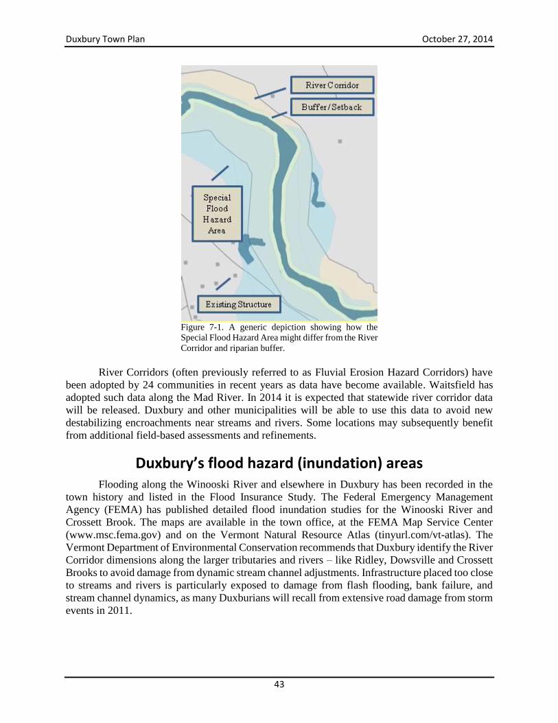
Duxbury Town Plan October 27, 2014
43
Figure 7-1. A generic depiction showing how the
Special Flood Hazard Area might differ from the River
Corridor and riparian buffer.
River Corridors (often previously referred to as Fluvial Erosion Hazard Corridors) have
been adopted by 24 communities in recent years as data have become available. Waitsfield has
adopted such data along the Mad River. In 2014 it is expected that statewide river corridor data
will be released. Duxbury and other municipalities will be able to use this data to avoid new
destabilizing encroachments near streams and rivers. Some locations may subsequently benefit
from additional field-based assessments and refinements.
Duxbury’s flood hazard (inundation) areas
Flooding along the Winooski River and elsewhere in Duxbury has been recorded in the
town history and listed in the Flood Insurance Study. The Federal Emergency Management
Agency (FEMA) has published detailed flood inundation studies for the Winooski River and
Crossett Brook. The maps are available in the town office, at the FEMA Map Service Center
(www.msc.fema.gov) and on the Vermont Natural Resource Atlas (tinyurl.com/vt-atlas). The
Vermont Department of Environmental Conservation recommends that Duxbury identify the River
Corridor dimensions along the larger tributaries and rivers – like Ridley, Dowsville and Crossett
Brooks to avoid damage from dynamic stream channel adjustments. Infrastructure placed too close
to streams and rivers is particularly exposed to damage from flash flooding, bank failure, and
stream channel dynamics, as many Duxburians will recall from extensive road damage from storm
events in 2011.
Duxbury Town Plan October 27, 2014
44
Looking at e-911 locations (December 2012), 38 (6 percent of all structures in Duxbury)
are within the Special Flood Hazard Area as identified on the Preliminary Washington County
Digital Flood Insurance Rate Map (March 19, 2013). See Table 7-1 below.
The structures include 35 residential single-family homes, mobile homes or multi-family
residences. Any federally regulated lender providing mortgages, grants, or loans (including
disaster aid) to a structure in the Special Flood Hazard Area must assure that the value of that
investment is covered by flood insurance.
The FEMA Individuals and Households Program (IHP) provided $36,275 to individual
households after Tropical Storm Irene. These funds cannot cover insurance loses and any structure
that has received IHP aid must maintain flood insurance. FEMA public assistance to the Town was
$629,595 and the National Flood Insurance Program provided four homeowners with a total of
$280,787.
An additional 11 structures are identified to be within the extent of the 0.2 (500-year)
percent annual chance flood hazard. These include ten residential structures. No critical or public
structures are located in the 0.2 percent flood hazard area. Federal capital funds may not be
invested in critical facilities located within the 0.2 percent and 1 percent annual probability flood
hazard areas. Route 100, River Road, Main Street, and the access road to Crossett Brook
Elementary School are exposed to inundation risk.
Table 7-1. Existing structures in the Mapped Flood Hazard Areas
Structure Type Number
Commercial 1
Public Gathering 2
Mobile Home 24
Multi Family 1
Single Family 10
Total E-911 38
The Town of Duxbury Local Hazard Mitigation Plan (LHMP) was approved on March 11,
2013. The Duxbury LHMP identifies known hazard issues in town and allows Duxbury to seek
FEMA Hazard Mitigation Grant funds to reduce current risk levels. The Duxbury LHMP lists flash
flood/flood/fluvial erosion events in the community including some of the damage experienced
since 1927. It also lists hurricanes/tropical storms/severe storms since 1938, though it is noted that
the historical extent of these events is not well documented in Duxbury. Duxbury experienced
almost $3 million worth of damage from storms in May and August of 2011. The areas most
affected by those storms remain at risk from future storms. Duxbury has not applied for or received
any HMGP funds that were released following the Irene disaster declaration.
Duxbury received a flood hazard boundary map in 1974 and joined the National Flood
Insurance Program in June of 1975. The current Flood Insurance Rate Map and Flood Insurance
Study were published in March of 1984. The Washington County Digital Flood Insurance Rate
Map (DFIRM) became effective in March of 2013. The DFIRM shows the current flood hazard
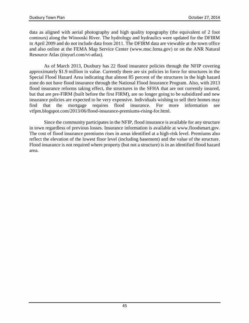
Duxbury Town Plan October 27, 2014
45
data as aligned with aerial photography and high quality topography (the equivalent of 2 foot
contours) along the Winooski River. The hydrology and hydraulics were updated for the DFIRM
in April 2009 and do not include data from 2011. The DFIRM data are viewable at the town office
and also online at the FEMA Map Service Center (www.msc.fema.gov) or on the ANR Natural
Resource Atlas (tinyurl.com/vt-atlas).
As of March 2013, Duxbury has 22 flood insurance policies through the NFIP covering
approximately $1.9 million in value. Currently there are six policies in force for structures in the
Special Flood Hazard Area indicating that almost 85 percent of the structures in the high hazard
zone do not have flood insurance through the National Flood Insurance Program. Also, with 2013
flood insurance reforms taking effect, the structures in the SFHA that are not currently insured,
but that are pre-FIRM (built before the first FIRM), are no longer going to be subsidized and new
insurance policies are expected to be very expensive. Individuals wishing to sell their homes may
find that the mortgage requires flood insurance. For more information see
vtfpm.blogspot.com/2013/06/flood-insurance-premiums-rising-for.html.
Since the community participates in the NFIP, flood insurance is available for any structure
in town regardless of previous losses. Insurance information is available at www.floodsmart.gov.
The cost of flood insurance premiums rises in areas identified at a high-risk level. Premiums also
reflect the elevation of the lowest floor level (including basement) and the value of the structure.
Flood insurance is not required where property (but not a structure) is in an identified flood hazard
area.
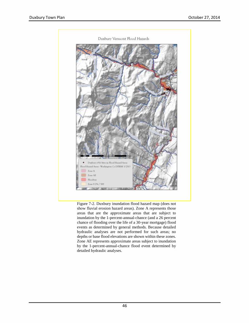
Duxbury Town Plan October 27, 2014
46
Figure 7-2. Duxbury inundation flood hazard map (does not
show fluvial erosion hazard areas). Zone A represents those
areas that are the approximate areas that are subject to
inundation by the 1-percent-annual-chance (and a 26 percent
chance of flooding over the life of a 30-year mortgage) flood
events as determined by general methods. Because detailed
hydraulic analyses are not performed for such areas; no
depths or base flood elevations are shown within these zones.
Zone AE represents approximate areas subject to inundation
by the 1-percent-annual-chance flood event determined by
detailed hydraulic analyses.
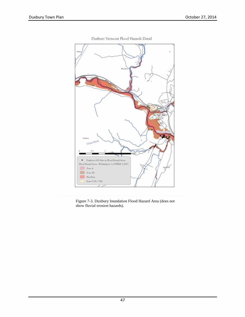
Duxbury Town Plan October 27, 2014
47
Figure 7-3. Duxbury Inundation Flood Hazard Area (does not
show fluvial erosion hazards).
Duxbury Town Plan October 27, 2014
48
Figure 7-4. Inundation Hazard Area Detail (does not show
areas of fluvial erosion hazard).
Duxbury’s Fluvial Erosion Hazard areas
The Duxbury Hazard Mitigation Plan ranks the highest three significant threats to the town:
Flash flood/flood/fluvial erosion
Hurricane, severe storms/tropical storms
Wildfire/forest fire
Due to the frequent and severe nature of flooding events (and Duxbury’s settlement
patterns along streams in areas with steep slopes), flooding has been identified as the worst natural
hazard within the town. Erosion (not inundation) hazards appear to be the greatest threats from
storm events. It bears reemphasizing that the greatest threat from floods in Duxbury is from
localized severe storms that affect these small, flashy watersheds (that respond quickly to
precipitation events) where there is a lot of infrastructure (e.g. culverts, roads, bridges) adjacent to
Duxbury Town Plan October 27, 2014
49
the stream. This results in fluvial erosion damage to public infrastructure and private property
located along these streams.
The fluvial erosion hazard areas of Duxbury are not currently mapped but we anticipate a
statewide river corridor map in 2014. At that time, this plan will adopt by default that map into
this section. Duxbury should pursue grants for additional field-based geomorphic data on local
waterways and crossing structures.
The Duxbury Zoning Regulations (January 31, 2011) meet requirements for participation
in the National Flood Insurance Program. However, since they do not avoid new encroachments
into the River Corridor or Special Flood Hazard Area, they allow new structures and
encroachments to aggravate the risk to existing structures, investments, and public safety. Changes
to the Emergency Relief and Assistance Fund (ERAF) rules require towns to take specific steps to
continue to qualify for the most favorable reimbursement rates following a presidentially declared
disaster. While Duxbury meets some of these requirements, the town should adopt rules to protect
mapped river corridors from new encroachments. This effort will involve working with the Central
Vermont Regional Planning Commission to update the regulations and to secure geomorphic
assessments and River Corridor data for the town. Updated flood hazard area regulations should
avoid new encroachments into the Special Flood Hazard Areas and River Corridors so as to not
degrade current floodplain services and increase the risk of damage to the many existing structures
in the hazard zone.
In addition, any of the three primary threats could close off access to residents and
emergency services. For example, Camels Hump Road area residents experienced a lack of
emergency access during storms in 2011. Duxbury should consider this, and other, threats to
isolated areas with single routes of access and explore alternative routes for cases of emergency
access/egress.
Act 16 also encourages flood resilient communities. It states:
A. New development in identified flood hazard, fluvial erosion, and river corridor
protection areas should be avoided. If new development is to be built in such
areas, it should not exacerbate flooding and fluvial erosion.
B. The protection and restoration of floodplains and upland forested areas that
attenuate and moderate flooding and fluvial erosion should be encouraged.
C. Flood emergency preparedness and response planning should be encouraged.
Under Act 16 the Town Plan and the local flood hazard regulations are required to be in
accordance with each other and they are not. This gap should be closed.
Stream Assessments
There are many reasons to do a stream geomorphic assessment, ranging from learning
about the natural environment and the effects humans have had on the landscape over time, to
identifying high quality aquatic habitats, to characterizing erosion and flood hazards. Mapping
River Corridors is not just about identifying hazards, but about identifying the area the stream
needs for physical adjustment, so that it can attain/maintain an stable equilibrium condition. This
distinction is important because River Corridor maps can’t identify all erosion hazards, and the
Duxbury Town Plan October 27, 2014
50
ultimate goal is to allow the streams room, with time, to regain a balance between water and
sediment moving downstream through the system. While mapping efforts often focus on the
hazard aspect, there is an important but broader benefit to the long-term health of the river system
and to our communities.
Data collected during stream geomorphic assessments will not only enable Duxbury to
better understand the physical processes and features shaping our watersheds but will also help us
by making knowledgeable and strategic decisions about how to best protect, manage, and restore
our watershed resources.
There are three levels of assessment for Vermont’s streams: Phases 1, 2, and 3.
Phase 1 is the most basic assessment that helps to flag stream reaches and field studies for
future evaluation to record reference conditions and complete impact ratings.
Phase 2, the rapid field assessment phase, involves the collection of field data from
measurements and observations at a smaller scale. Stream geomorphic condition, physical habitat
condition, adjustment processes, reach sensitivity, and stage of channel evolution are based on
field measurements of various parameters. Phase 2 assessments can take 1 to 2 days in the field
for a one mile reach. Stream geomorphic and habitat assessment skills are necessary, but there are
plenty of tasks that can be completed or assisted by someone with limited training. The Phase 2
assessment is ideal for flagging reaches for protection and restoration projects and the completion
of Phase 3 assessments.
Phase 3, the survey-level field assessment phase, involves the collection of detailed field
measurements at the sub-reach or river site scale. Existing stream types and adjustment processes
are further detailed and confirmed based on quantitative measurements of channel dimension,
pattern, profile, and sediments. Phase 3 assessments are completed with field survey and other
accurate measuring devices and can take 3 to four days to survey a sub-reach of two meander
wavelengths. Professional level stream survey and geomorphic assessment skills are necessary.
Phase 3 assessments are typically pursued to augment data requirements for the design and
implementation of river corridor protection or restoration projects.
Phase 3 mapping is not always needed. The most tangible follow-up to Phase 2 is River
Corridor planning. For example, the Mad River has several River Corridor plans (most recently
for the Upper Mad River), which are documents that seek to identify potential restoration
opportunities that support the goal of restoring physical stream stability (i.e. equilibrium condition)
in the watershed context. Phase 3 is a more detailed field methodology that may be used in
designing restoration projects that are identified in the river corridor plan.
Phase 1 geomorphic assessments of the Winooski River, Ridley Brook and Crossett Brook
in Duxbury have been completed. A mid-Winooski Watershed Phase 1 assessment was completed
in 2007.
Field-based Phase 2 assessments of streams in Duxbury have not been completed. The
Vermont Agency of Natural Resources expects to make available statewide river corridors based
Duxbury Town Plan October 27, 2014
51
on topographic data in 2014. However, because they provide more detailed data, the town would
still benefit from pursuing Phase 2 assessments to secure additional geomorphic, bridge/culvert,
and habitat information. Geomorphic assessments of stream crossing structures (culverts and
bridges) can also identify undersized structures and their likely mode of failure. Such data can be
incorporated into the Hazard Mitigation Plan.
Duxbury should adopt River Corridors/Fluvial Erosion Hazard (FEH) Areas and secure
funding for Phase 2 assessments. Northfield and Waitsfield have incorporated Fluvial Erosion
Hazard Areas into their current bylaws. Warren and Moretown are currently working on related
updates and Stowe and Worcester both have FEH in flood hazard regulations.
Central Vermont Regional Planning Commission and the Friends of the Winooski River
are both possible partners to pursue grants and to manage the contracts needed to complete this
work. In the absence of River Corridor data Duxbury may want to use Phase 1 based corridor
delineations and recommended geomorphic setbacks, and adopt statewide river corridors, when
they are released in 2014, along tributaries that will not be field assessed due to funding, size, or
stream gradient.
Duxbury should also investigate the Vermont Flood Resilient Communities Program,
established in 2012. The Flood Resilient Communities Program will provide favorable grant
matching funds from the state for damage mitigation efforts and other grants to municipalities. At
this time, due to resource constraints, the effort involved and the subsequent return for this effort,
the Planning Commission does not recommend pursuing an application to the FEMA Community
Rating System (CRS) to qualify for discounted flood insurance. Bennington, Brattleboro, and
Montpelier currently participate in CRS. More information on that program can be found at:
www.fema.gov/national-flood-insurance-program/national-flood-insurance-program-
community-rating-system.
This iteration of the Duxbury Town Plan incorporates the Town of Duxbury, VT Local
Hazard Mitigation Plan as formally approved by FEMA on March 11, 2013.
River Corridor Overlay
To minimize flooding inundation hazards, Flood Hazard Area regulations limit and
regulate development within mapped floodplains that are susceptible to a 1 percent annual chance
of flooding (i.e. the 100-year FEMA floodplain). These regulations are required for town
participation in the National Flood Insurance Program (NFIP). Duxbury has participated in this
program since 1974.
The Vermont Rivers Program is current coordinating a statewide effort to map Fluvial
Erosion Hazard areas along rivers and streams. Given Duxbury’s topography and hydrological
characteristics, the town is at great risk of erosional hazards – as evidenced in 2011 when a storm
in May and Tropical Storm Irene in August necessitated erosional hazard repairs at a cost of almost
$3 million. This does not include municipal and state contributions for that event. Duxbury could
expand its flood provisions to include fluvial erosion hazards for areas at risk from gradual or
catastrophic stream bank failure. The state has also prepared model regulations for fluvial erosion
Duxbury Town Plan October 27, 2014
52
hazard areas that discourage development and encourage retention or establishment of woody
vegetation in these riparian areas.
The Vermont River Management Program (RMP) strongly encourages towns to adopt
additional regulatory measures that go above and beyond the NFIP minimum requirements. The
best way to increase public safety, decrease flood damage, and decrease the Duxbury’s
administrative burden is to adopt regulations that exclude most new development from the Special
Flood Hazard Area.
To protect against property loss and public infrastructure damage (especially the many
gravel roads and culverts located on or near steep gradient streams like Crossett and Ridley
Brooks) from stream channel movement, Duxbury should limit development in all districts in areas
of high erosion risk (as indicated on Agency of Natural Resources River Management Program
river corridor maps). An appropriate by-law should be adopted to accomplish this goal.
Riparian Buffers
Riparian buffers are an integral part of river corridors and lakeshores. In addition to
reducing flood hazards and stabilizing stream banks, naturally vegetated riparian buffers provide
a number of important environmental functions and values including flood attenuation, aquatic
and terrestrial habitat, creating wildlife corridors, filtering runoff and adsorbing nutrients, shading
streams to keep them cool, and more. Since Duxbury lacks natural lakes and ponds, riparian buffer
protection is focused on streams and rivers.
Generally, a naturally vegetated 50-foot-wide riparian buffer on each side of a stream will
minimize soil erosion, while a 100-foot-wide buffer will also protect many of the functions
associated with healthy riparian habitat and help to protect property owners from damage or
property loss due to erosion hazards. However, to provide travel corridors and habitat for many
species, wider buffers may be needed. Given the interconnectedness of all streams in Duxbury, it
is recommended that riparian buffer setbacks be incorporated on all perennial and intermittent
streams. For more information on this, the reader is referred to: Reading Vermont's Rivers
(http://vnrc.org/vnrc-releases-new-rivers-publication/).
Duxbury’s zoning ordinance does not require protection of riparian buffers, nor does it
meet current requirements of the Vermont League of Cities and Towns model ordinance. The
zoning ordinance should be amended to correct this deficiency and establish a science-based buffer
protection standard.
Dams
While dams once provided power for mills in Duxbury, there are few dams remaining in
the town. The most significant structure is the Bolton Falls hydroelectric dam on the Winooski
River, owned and operated by Green Mountain Power. There are a few other structures on smaller
streams, but none are currently operated for hydroelectric power or other uses.
Major instream infrastructure like dams, even small dams on small streams, can lead to
stream instability by disrupting the natural downstream transport of sediment and have significant
Duxbury Town Plan October 27, 2014
53
impacts on fish and other aquatic life. Construction of new dams should be avoided, and this issue
should be addressed in the zoning ordinance.
Wetlands
As noted in the Natural Resources section of this plan, Duxbury is well served by many
wetlands. Most wetlands perform some level of flood storage and Duxbury’s high elevation
headwater seeps and vernal pools have not yet been inventoried by Duxbury or by the Agency of
Natural Resources. Because of the role that these wetlands play in preventing flood damage (or,
alternatively, the increase in flood damage that could be expected if these wetlands were not
present), an inventory of all of Duxbury’s wetlands and vernal pools is worth considering.
Wetlands identified can then be added to the official Vermont Significant Wetland Inventory maps
(as appropriate) to ensure future protection from development. Wetland resource maps can be
viewed on the Vermont Natural Resource Atlas tiny.url.com/vt-atlas. Please see the ANR
Wetlands section at www.watershedmanagement.vt.gov.
Forest Resources Forest cover plays an important role in attenuating water flow from precipitation and
moderating flood impacts. Where land cover in watersheds has become increasingly developed
and impervious to infiltration the effects on stream channel adjustments and inundation can
become heightened. For this reason and others, Duxbury places a high priority on maintaining a
high level of forest cover. See section on Forests and Forest Resources of this town plan.
Emergency Response Planning Currently Duxbury has a Local Emergency Operations Plan (LEOP) that identifies
responsibilities and actions that will be taken during a local emergency, including flood
emergencies. The plan is required to be updated and submitted to the State of Vermont on an
annual basis. An updated LEOP is one of four required criteria for towns to be eligible for a higher
state cost share (12.5 percent) from the Emergency Relief and Assistance Funds for flood recovery
projects in the case of a federally-declared disaster.
The Town’s Emergency Management Committee meets monthly and makes emergency
preparedness resources available on the municipal web site.
Duxbury Town Plan October 27, 2014
54
Goal, Objectives and Strategies Goal: Water resources and the built environment are not in conflict
Objectives
Avoid new development in identified flood hazard, fluvial erosion, and river corridor
protection areas. If new development is to be built in such areas, it does not exacerbate
flooding and fluvial erosion.
Encourage the protection and restoration of floodplains and upland forested areas that
attenuate and moderate flooding and fluvial erosion.
Engage in flood emergency preparedness and response planning.
Strategies
Secure a geomorphic assessment (Phase 2) of Ridley Brook, Crossett Brook, and the
Winooski River to identify areas subject to normal channel erosion processes and avoid
loss of floodplain functions. Phase 1 Assessments should be conducted on Welder Brook,
Dowsville Brook, and Shepard Brook. All of these should be done to establish River
Corridor Plans and River Corridor (FEH) delineations. The assessments should also
collect data on the geomorphic compatibility of stream crossing structures (culverts,
bridges).
Undertake at least a Phase 1 assessment to delineate river corridors. Or, adopt statewide
river corridors when they are released in 2014. Duxbury should use setback and buffer
standards to address hazards, water quality, and habitat impacts.
Set stream bank setbacks and buffer standards in the zoning ordinance based on default
geomorphic standards and from VT DEC and VLCT model ordinances for all streams in
Duxbury.
Update flood hazard area and river corridor regulations to meet standards in the current
Vermont flood hazard area regulation model. Duxburians may be aware of other issues
related to frequent flooding, dam safety, ice jams or other issues that should be identified
and addressed either in the hazard area regulations, the Hazard Mitigation Plan, the Local
Emergency Operations Plan or all three. Explore the benefits of participating in the floodplain restoration project with the Town
of Waterbury.
Establish hazard area standards so as to qualify for Vermont Flood Resilient Communities
matching funds.
Establish and sustain a flood hazard area education and outreach effort to support flood
damage mitigation and better insure community residents and property for future flood
damage.
Explore participation in the FEMA Community Rating System (CRS) so as to secure a
discount on flood insurance.
Establish clear guidelines to promote appropriate flood mitigation for historic structures
in the Special Flood Hazard Area.
Recruit and support a community committee to pursue hazard mitigation efforts.
Duxbury Town Plan October 27, 2014
55
Annually update the Local Emergency Operations Plan. Seek advice from the CVRPC,
Selectboard members and other emergency officials about what works well and where
improvements might be made with coordination, public information, evacuation, staff,
training, equipment needs by responders and road crew etc. Explore alternative routes for
cases of emergency access/egress for areas of Duxbury with singular routes of access.
Work with first responders, Emergency Management, and the road crew to plan improved
emergency response capacity (operations, training, equipment) during natural disasters as
identified in the Town of Duxbury, VT Local Hazard Mitigation Plan.
Implement the Hazard Mitigation Plan for the town in conjunction with the CVRPC and
others. Complete a town-wide wetland inventory and work with Agency of Natural Resources to
add them to the Vermont Significant Wetland Inventory Maps as appropriate.
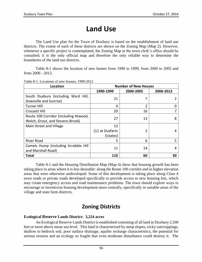
Duxbury Town Plan October 27, 2014
56
Land Use
The Land Use plan for the Town of Duxbury is based on the establishment of land use
districts. The extent of each of these districts are shown on the Zoning Map (Map 2). However,
whenever a specific project is contemplated, the Zoning Map in the town clerk’s office should be
consulted; it is the only official map and therefore the only reliable way to determine the
boundaries of the land use districts.
Table 8-1 shows the location of new homes from 1990 to 1999, from 2000 to 2005 and
from 2006 - 2012.
Table 8-1. Locations of new houses, 1990-2012
Location Number of New Houses
1990-1999 2000-2005 2006-2012
South Duxbury (including Ward Hill, Dowsville and Sunrise)
21 7 2
Turner Hill 4 2 0
Crossett Hill 29 16 7
Route 100 Corridor (including Atwood, Welch, Grout, and Stevens Brook)
27 13 8
Main Street and Village 13 (11 at Duxfarm
Estates) 2 4
River Road 5 6 5
Camels Hump (including Scrabble Hill and Marshall Road)
11 14 4
Total 110 60 30
Table 8-1 and the Housing Distribution Map (Map 4) show that housing growth has been
taking place in areas where it is less desirable: along the Route 100 corridor and in higher elevation
areas that were otherwise undeveloped. Some of this development is taking place along Class 4
town roads or private roads developed specifically to provide access to new housing lots, which
may create emergency access and road maintenance problems. The town should explore ways to
encourage or incentivize housing development more centrally, specifically in suitable areas of the
village and state farm districts.
Zoning Districts
Ecological Reserve Lands District: 3,224 acres
An Ecological Reserve Lands District is established consisting of all land in Duxbury 2,500
feet or more above mean sea level. This land is characterized by steep slopes, rocky outcroppings,
shallow to bedrock soil, poor surface drainage, aquifer recharge characteristics, the potential for
serious erosion and an ecology so fragile that even moderate disturbance could destroy it. The
Duxbury Town Plan October 27, 2014
57
subalpine forests and vegetation which cover these lands play a vital part in replenishing regional
water supplies. While much of this area is publicly owned, access is possible only on foot. Finally,
this district contains important wildlife habitat and comprises a unique wilderness area with
Camels Hump as its dominant feature.
Uses in this district will be restricted to the maximum extent allowed by the law.
Agricultural and forestry uses will be permitted, as will such low-intensity non-commercial uses
as hunting, cross-country skiing, hiking or nature study. Structures attendant to these low-intensity
uses may be conditionally permitted, provided they do not destroy the natural vegetative cover or
cause undue erosion. No seasonal or residential structures whatsoever will be permitted in this
district.
Timber Management and Wildlife District: 11,332 acres
A Timber Management and Wildlife District is established consisting of all land between
1,500 and 2,500 feet above mean sea level. Woodlands, either mature second-growth forests or
plantations of pine or spruce, comprise much of this district. As a rule the soils in this district are
shallow and well-drained due to the fact they are overlaid on moderate-to-steep slopes; they also
exhibit aquifer recharge characteristics. Besides containing the headwaters of such important
streams as Dowsville, Crossett and Ridley Brooks, this district also provides vital wildlife habitat
as described in the Natural Resources chapter.
Agricultural and forestry uses are appropriate in this district. However, any disturbance to
the land must be done with the utmost care in order to prevent soil erosion, contamination of
ground or surface waters or the destruction of wildlife habitat. Landowners are reminded that at a
minimum all logging operations must conform to the Accepted Management Practices (AMPs) of
the Vermont Department of Forest, Parks and Recreation to ensure water quality is protected and
soil loss minimized. Land use in this district must consider the potential impact on wildlife habitat,
aesthetics, water quality of headwater streams (and impacts on downstream waters) and the
availability of an adequate land-base for dispersed, non-commercial outdoor recreation such as
hiking and hunting. The public has a clear interest in protecting some of these public trust resources
including clean surface and groundwater and viable wildlife populations. Low-intensity
recreational uses, therefore, as described in the Ecological Reserve District, are also appropriate
and encouraged.
Maintaining access for recreation is, of course, largely dependent on the cooperation of
private landowners. Options to maintain and encourage public access, including property tax
abatement in exchange for leaving property open for access should be explored.
Development in this district should be significantly restricted. Maintaining a land base for
forestry helps to maintain Duxbury’s rural character and working landscape and contribute to the
local economic base in a sustainable manner. Development for housing in this district has grown
in recent years and if continued will threaten the productivity of the land due to increased soil
erosion and fragmentation of wildlife habitat. Further, development places additional burdens on
the town, i.e., providing services and road maintenance.
Duxbury Town Plan October 27, 2014
58
Structures of any kind will be permitted only upon issuance of a conditional use permit.
The Development Review Board (DRB) will review site plans prepared by a registered
professional engineer to ensure that neither construction nor maintenance of any structure or road
will result in soil erosion or contamination of ground or surface waters. Furthermore, any necessary
road improvements will be entirely the responsibility of the landowner and will be accomplished
at no expense to the Town. Within these limitations residential construction may be permitted with
a minimum lot size of 25 acres per unit, subject to review by the DRB. However, development in
this district (including the conversion of seasonal camps into year-round residences) is not
encouraged by this plan for the reasons mentioned above and because the provision of Town
services to this district is extremely difficult. Therefore, the extension of electric power into this
area is strongly discouraged and, in any case, any utility lines must be placed underground.
Forest - Recreation District: 8,390 acres
A Forest-Recreation District is established as shown on the Land Use Plan map. Most of
this area is characterized by steep slopes, shallow soils and general lack of improved access. In
general, the better-drained soils tend to be shallow and are found on the steeper slopes, while the
deeper soils are found in less well-drained pockets. Ledge and rock outcroppings are common
throughout. Also, a number of important streams, namely Dowsville, Crossett and Ridley Brooks,
flow through this district, and it is essential that the purity of such waters be protected. Most of
this district is far enough removed from available Town and community services that provision of
such services to an increased population would be both difficult and expensive to the Town.
Indeed, maintaining the existing road network, for example, is proving to be challenging to the
Town of Duxbury due to the proximity of many of our roads to dynamic streams. Limited
proximity to town services should limit development in areas of productive forestland, areas with
steep slopes, bear habitat or deer yards, and higher elevations that are highly visible from town
roads.
Agriculture, forestry, recreation, permanent single-family and seasonal single-family
dwellings are permitted in this district provided that such uses will not result in soil erosion or
contamination of ground or surface waters, that adequate access from a Class 3 or equivalent road
is provided at no cost to the Town, and that significant wildlife habitats are left undisturbed. Within
these limitations, residential construction is permitted with a minimum lot size of five acres per
unit and a buffer zone of 100 feet from Dowsville, Crossett or Ridley brooks shall be maintained.
Conversion of camps to year round residences are permitted with the demonstration via a
Wastewater and Water Supply permit from the Agency of Natural Resources that the land can
assimilate wastewater and provide adequate water supply.
Maintaining a land base for forestry and for protecting ground and surface water quality
helps to maintain Duxbury’s rural character and working landscape, contributes to the local
economic base in a sustainable manner, and protects public trust resources for all residents. At the
same time, the current demand for housing options for local residents is not expected to decline
and a significant portion of the town’s new residential growth will likely occur in this district.
Maintaining a land base for the production of forest products while accommodating the demand
for housing is a primary challenge for Duxbury.
Duxbury Town Plan October 27, 2014
59
Rural - Agricultural District I: 3,175 acres
A Rural-Agricultural District, as shown on the Land Use Plan, is established in the eastern
section of town. This district is characterized by gentle to moderate slopes and deep to moderately
deep soils formed from glacial till. These soils tend to be stony and at intervals gravely, or silty
loam where terrain is level.
This district runs along Vermont 100, the main travel corridor through the town, and
therefore enjoys convenient access to town and community services. Not surprisingly, this corridor
has historically been an area of agricultural and residential use, although today it is almost
exclusively residential in nature. Additionally, there are now two schools located along Vermont
100: Harwood Union High School, built in 1966 at the southern end of town, and the Crossett
Brook Middle School, built in 1997 on part of the former State Farm. A more complete description
of this corridor is found in Chapter 11.
Vermont 100 is recognized as a popular tourist destination and a scenic byway. This
highway, running from southern Vermont to the Canadian border, is known as one of the most
scenic drives in New England and is part of “Skiers Highway” which connects some of the best
skiing and riding opportunities in the northeast. This route has a wide range of resources – historic,
cultural, scenic, natural, and recreational and runs through the heart of this district. Vermont 100
connects residents in South Duxbury to neighboring Waterbury, Moretown and beyond. It serves
as one of Duxbury’s primary paved roadways and as a gateway into South Duxbury.
The residential character of Vermont 100, as well as its scenic attributes, underscores the
need for this Plan to address in specific terms the possible threats to this highway corridor and the
measures that must be taken to protect it against excessive residential growth or strip development.
In 1989 the residents of Duxbury in overwhelming numbers agreed that the preservation of the
town’s rural character should be an overriding goal of the Town Plan. That principle was
reaffirmed when the Plan was readopted in 1996 and yet again at a public forum held in June of
2000. It is doubtful that anything could be more contrary to that desire than strip development
along Vermont 100. As a consequence, any business conditionally approved in this district must
be appropriate to the surrounding area (that is, not block or mar scenic vistas, not crowd out or
impinge on the residential aspect of the neighborhood) and must be small enough not to place
undue burdens on the town’s resources. In addition, the Development Review Board shall take
into account the incremental and cumulative impacts of each conditional use allowed or considered
so that the residential nature of the highway corridor is not gradually subverted over time.
Whereas commercial or business uses in this district will only be conditionally permitted,
residential and agricultural uses, as well as forestry and non-commercial recreation, will be
permitted. A maximum density of one unit per acre will be permitted for residential development;
however, all multi-home developments should include provisions for open space, and PUDs are
especially encouraged and may be conditionally permitted.
It bears repeating that in this district any development, whether residential or commercial,
should strive to preserve open space and scenic vistas. This is especially true for the section of
Vermont 100 from Stevens Brook Road north to the Crossett Brook Middle School, since this
stretch offers several superb vistas, most notably of Mount Hunger. However, all of Vermont 100
Duxbury Town Plan October 27, 2014
60
in Duxbury merits careful planning in order to preserve its scenic and residential characteristics.
A number of specific recommendations for accomplishing this goal are listed in Chapter 11.
Rural - Agricultural District II: 809 acres
This district, as shown on the Land Use Plan, is bounded by the Winooski River on the
north, the Village District on the east, a line 500 feet south of and parallel to River Road on the
south, and the Bolton town line on the west. Much of this land possesses soil of high suitability
for agriculture; much also lies within the federally-designated Special Flood Hazard Area, state-
mapped River Corridor, or both. In addition, the River Road offers a series of panoramic views
across the valley of the Winooski to the Bolton range of mountains to the north.
All development in this District shall be subject to the same conditions and limitations that
pertain to Rural-Agricultural District I. Furthermore, only agricultural or other open-space uses
are appropriate north of River Road, whether or not the land in question lies in the Special Flood
Hazard Area or River Corridor. Even residential development is strongly discouraged here since
seasonal flooding is often widespread and the scenic qualities are so significant.
Village District: 85 acres
A Village District is established in the northeast section of town as shown on the Land Use
Plan. This area is already quite fully developed due to gentle slopes, good soil conditions and
proximity to Town services. Consequently, a mixture of village-type uses is encouraged and
permitted at a density of one unit per acre.
Some areas of Duxbury are better suited than others for moderate and high density
residential development. This is especially true in areas of historic development near town
services. Therefore, developments in this district within historically developed areas may be
permitted at greater densities than in other areas. The goal is to encourage development to areas
that are better suited for it, by reducing the burden on the Town to provide services to more remote
areas, lowering the impact on natural resources in those districts where resource protection is a
priority and avoiding sprawl along the Vermont 100 corridor. Commercial activity should be
evaluated for compatibility with the neighborhood, access, traffic circulation and parking
requirements.
To achieve the goal of encouraging development in the village, rather than having it sprawl
into other areas of the town, the Planning Commission will evaluate reducing the village lot size
and setback requirements in the zoning regulations to increase density.
State Farm District: 482 acres
The former State Farm is a prominent feature of the town of Duxbury. Situated on both
sides of Vermont 100, this area provides an expanse of open fields with views of mountains and
ridgelines to both the north and south. It is a scenic gateway, a most pleasing transition from the
commercial district of Waterbury to the rural beauty of Duxbury’s hills and ridges. In addition, the
State Farm is a historic landmark from the time when much of the food for the Vermont State
Hospital in Waterbury was raised here in the fields, the dairy barn and the piggery.
Duxbury Town Plan October 27, 2014
61
To preserve these features, a State Farm Zoning District is established. The purpose of this
district is to facilitate limited commercial and residential development of this property while
preserving agricultural land, forests and wetlands.
The Zoning District divides this property into eight parcels. The Crossett Brook School
occupies one parcel, and a small industrial business has been established on the parcel adjoining
Holy Cross Cemetery. The Town of Duxbury purchased the 37.7-acre “plateau site” across from
the Town offices so that the Town would have a convenient and economical source of gravel. A
private residence occupies the 53-acre development portion of the former Crossett Hill Section of
the State Farm. The State of Vermont is retaining ownership of two parcels on River Road reserved
for agriculture, forestry and recreation.
The parcel (37 acres) around the barns and between Crossett Brook School and Crossett
Brook and an adjacent 101 acres of wetland were recently purchased from the State of Vermont.
The land around the barns is being developed into a lumber yard and the land behind Crossett
Brook School is planned for mixed use.
The Master Plan recommended that the land designated as agricultural, forestry or wetlands
be permanently preserved by transferring either full ownership or development rights to a land
trust at the time these parcels pass out of State ownership. The Duxbury Land Trust was approved
by the DRB in 2004 as the designated entity to hold the easements on the conserved lands. The
land trust holds easements on the following parcels: a portion of the Crossett Hill parcel (73 acres),
the River Road parcels (92 acres) and the wetland parcel behind Crossett Brook School (101 acres).
Special Limitation on Large Land Developments
Even without the pressure of large-scale land developments or subdivisions, between 1990
and 2000 the population of Duxbury has increased from 976 to 1,289, in an increase of 32 percent,
while the population of Washington County as a whole grew by less than 6 percent. Fortunately,
the town’s growth rate diminished dramatically to about 4 percent from 2000-2010, while
Washington County grew at a rate of 3 percent over the same period.
The reduction in the growth rate since 2000 notwithstanding, the town’s citizens must be
mindful of questions related to an increasing population:
1. Will Duxbury be able to retain its identity as a small rural community, which has repeatedly
(in 1989, 1996, 2000 and 2010) been identified in public forums as a top priority for the
Town’s future planning?
2. Will existing Town services be sufficient for an ever-increasing population?
3. How does Duxbury balance increasing growth with strain on town services?
These concerns are of such magnitude that only one conclusion is possible: large-scale land
developments are inappropriate in Duxbury and should be discouraged. Simply put, existing
development pressures pose enough growth-related problems; the added pressures of larger
developments would seriously threaten the town’s rural identity and financial capability.
Duxbury Town Plan October 27, 2014
62
In recognition of the above, the DRB will carefully review any project calling for more
than ten additional housing units or building lots and may impose appropriate conditions such as
limits on further subdivision, the provision of open space, the phasing in of the development over
a period of years or the requirement that the development be submitted as a PUD. As noted in the
Housing section, 25 percent of units developed should be of affordable housing.
River Corridor Overlay To minimize flooding inundation hazards, River Corridor regulations limit and regulate
development within mapped floodplains that are susceptible to a 1 percent annual chance of
flooding (i.e. the 100-year FEMA floodplain). These regulations are required for town
participation in the National Flood Insurance Program (NFIP). Duxbury has participated in this
program since 1974.
While flood hazard area regulations were updated recently, Duxbury should adopt River
Corridor maps and develop regulations for areas at risk from gradual or catastrophic stream bank
failure. Given Duxbury’s topography and hydrological characteristics, the town is at great risk of
erosional hazards – as evidenced in 2011 when a storm in May and Tropical Storm Irene in August
necessitated erosional hazard repairs at a cost to Duxbury of close to $1 million.
The Agency of Natural Resources Rivers Program strongly encourages towns to adopt
additional regulatory measures that go above and beyond the NFIP minimum requirements. The
best way to increase public safety, decrease flood damage, and decrease the Duxbury’s
administrative burden is to adopt regulations that exclude most new development from the Special
Flood Hazard Area. The Rivers Program has developed maps that show some community’s risk
of flood damage due to erosion and others are under development.
Act 110 of the Vermont Legislature established the River Corridor Management Program
to aid and support the municipal adoption of river corridor and buffer bylaws.
The act dictated that state financial incentives be offered to municipalities through existing
grants and pass-through funding programs which encourage municipal adoption and
implementation of zoning bylaws that protect river corridors and buffers. As a result of this Act,
municipal zoning bylaws may permit, prohibit, restrict, regulate, and determine land development,
including the following:
(1) Specific uses of land and shoreland facilities;
(2) Dimensions, location, erection, construction, repair, maintenance, alteration, razing,
removal, and use of structures;
(3) Areas and dimensions of land to be occupied by uses and structures, as well as areas,
courts, yards, and other open spaces and distances to be left unoccupied by uses and
structures;
(4) Timing or sequence of growth, density of population, and intensity of use;
(5) Uses within a river corridor and buffer, as those terms are (now) defined in 10 V.S.A.
§§ 1422 and 1427.
To protect against property loss and public infrastructure damage (especially the many
gravel roads and culverts located on or near steep gradient streams like Crossett and Ridley

Duxbury Town Plan October 27, 2014
63
Brooks) from stream channel movement, Duxbury should limit development in all districts in areas
of high erosion risk (as indicated on Agency of Natural Resources River Corridor maps). An
appropriate by-law should be adopted to accomplish this goal.
Planned Unit Developments
The Town of Duxbury supports the concept of planned developments (as defined below)
since they can prove economically attractive while safeguarding such natural features as prime
agricultural and forestry soils, open spaces, scenic vistas and wildlife habitat that are important to
adjoining landowners as well as to the townspeople as a whole.
A Planned Unit Development (PUD) is an area of land to be developed as a single entity
according to a plan which consists of either commercial or residential buildings or uses, or both,
and which may cluster or concentrate structures in lot sizes or density not normally allowed by the
zoning ordinance.
The purpose of a Planned Unit Development is to encourage more efficient use of land and
energy, to encourage innovation in the design, layout and siting of structures, to preserve natural
and scenic qualities of open land and to provide housing at a more affordable price than might
otherwise be possible.
A PUD should be considered an opportunity. However, such development proposals must
be shown to serve at least some of the purposes enumerated above and must, in addition, be deemed
by the Development Review Board:
To be consistent with the Town Plan;
To be in harmony with the surrounding area, or to be sufficiently screened as to appear
harmonious;
To provide ample and safe access and parking;
And to provide adequately for the preservation of open space and such significant scenic
vistas, natural areas and/or wildlife habitat as the tract may contain. More specific standards
and conditions for planned developments will be set forth in the zoning ordinance.
Goal, Objectives and Strategies
Goal: Land development protects natural resources and maintains Duxbury’s rural character by
concentrating smaller scale commercial use and residential development in areas near services,
reducing strain on infrastructure and providing access to open space for recreation.
Objectives
Regulate land development in a manner that protects important natural resources while
encouraging a range of land uses in appropriate locations.
Maintain existing forest resources while promoting sustainable forest product enterprises.
Concentrate residential development in areas that does not increase strain on town
infrastructure or impact natural resources.
Duxbury Town Plan October 27, 2014
64
Strategies
Support development in the village district while maintaining rural countryside in
accordance with the land use plan and associated land use districts described in this section
and depicted on the Land Use Map. Address the limitations of a lack of public water and
wastewater supply as barrier to increased densities.
Administer land use regulations, including zoning and overlay districts in a fair and
consistent manner in accordance with the land use policies of this town plan.
Maintain the integrity of the Timber Management and Wildlife and the Forest-Recreation
Districts for the purpose of protecting forest resources and headwater streams and wetlands
and to limit development in areas with steep slopes, shallow soils, wildlife habitat, fragile
features, scenic resources and poor access to town roads and services. Accomplish this by:
o Limiting land use and development to forestry, outdoor recreation and year round
residential dwellings above 1,500 feet in elevation.
o Limit extension of roads and utilities above elevations of 1,500 feet except to
provide access to forestry operations and for recreation.
o Carefully control development to avoid adverse visual impacts, degradation of
groundwater and surface water quality and the large-scale fragmentation of
wildlife habitat and forest resources.
o Promote sound forest management to ensure that water quality and soil resources
are maintained in perpetuity.
Amend the zoning ordinance to achieve the following:
o Prohibit development of any kind above 1,750 feet in elevation.
o Require conditional use approval for development between 1,500 feet and 1,750
feet in elevation.
o Require a “view impact analysis” for any development above 1,000 feet in
elevation.
o Prohibit driveways in excess of an 8 percent slope.
o Require setbacks of 100 feet from streams.
o Require setbacks from wetlands as dictated by the Vermont Wetland Rules.
o Require parking for commercial uses at the side or rear of the structure served and
screened from view.
o Require that on land parcels 25 acres or greater, 75 percent of the parcel will
remain undeveloped.
o Require driveways longer than 750 feet to provide emergency vehicle turnouts.
o Require that development of any kind between Route 2 and the Crossett Brook
Middle School along Route 100 include the installation of sidewalks as a part of
the development.
o Assure that the State Farm and Middle School zoning regulations allow mixed and
residential development.
Encourage PUDs by developing incentives (e.g. higher density).
Increase allowed densities in the Village District.
Explore adding Duxbury’s portion of Route 100 to the state-designated “Green Mountain
Byway.”
Duxbury Town Plan October 27, 2014
65
Economic Development
Duxbury has opportunities to encourage economic development that simultaneously
preserve its natural beauty and rural character and provides jobs and a tax base for the town.
Economic areas to especially be encouraged are businesses within the working landscape (forestry,
agriculture, and value-added manufacturing of wood and agriculture products), hospitality and
tourism, and recreation. Duxbury is ideally located near prime tourist destinations: the Mad River
Valley, Stowe, and Waterbury. There are several opportunities to capitalize on this location to
generate economic opportunities that are in harmony with our landscape and culture.
Current Economy and Jobs Duxbury is primarily a rural residential community with no defined commercial center,
although there are small businesses scattered throughout the town. This situation is not so much
the result of planning or zoning as it is the result of topography. At least 90 percent of the town is
forested and most of this area is hilly or even mountainous with about one third of the town, along
the crest of the Green Mountains, in public ownership.
Most Duxbury residents work outside of town. Data from 2008 show that approximately
25 percent of Duxbury residents commuted to Chittenden County, and about 28 percent to
Waterbury.2 About 14 percent commuted to Montpelier, Barre or surrounding towns, and at least
10 percent commuted to Waitsfield or other towns in the Mad River Valley.
The main employers in the town are the two schools, Crossett Brook Middle School and
Harwood Union High School. The town also has at least two private child care facilities. Other
employers mainly consist of small service companies (auto mechanics) and small entrepreneurial
and home-based business.
Duxbury fortunately has a low unemployment rate compared to the state and the country.
In 2010 and 2011, 20 out of 820 residents in the civilian workforce were unemployed, or 2.4
percent. In May 2013, the unemployment rate was only 1.8 percent.
According to the Vermont Department of Labor, Duxbury had a total of 13 work
establishments in 2013. There are also likely several other businesses with sole proprietors. Ten
are service providers and one establishment manufactures durable goods. The two schools are
government. Total employment in the town was 209, a slight (2.5 percent) increase from 2012.
Approximately 75 percent of the jobs were at the two schools. The average private-sector wage
was $41,322 and the average government wage was $46,352. These numbers do not include sole
proprietary businesses that do not have employees.
Broadband internet and cellular phone services are vital for businesses to thrive in
Duxbury. While broadband availability has significantly improved in recent years, there are still
2 These data predate the closing of the Waterbury State Complex following Tropical Storm Irene, which displaced
most state workers to more-distant locations. While the complex will reopen, many workers have been permanently
relocated to Montpelier or other sites.
Duxbury Town Plan October 27, 2014
66
areas of the town that have inadequate coverage. Cell service does not exist in many Duxbury
neighborhoods, including most of North Duxbury and South Duxbury. The situation in North
Duxbury may be improved by new cell towers proposed by two carriers.
Community and Economic Development Opportunities
Municipalities can play a key role in developing planning strategies and partnerships to
promote job creation, brownfields redevelopment, community improvements, and sustainable
economic growth.
Economic sectors that should be encouraged in Duxbury include:
Tourism and recreation
Working landscape – agriculture and forest products
Home-based businesses and small service providing businesses
It would benefit our town to promote certain types of economic development to provide
quality jobs for its residents. The concern to keep its rural identity has been a concern for town
residents voiced in the past few town plan updates, as well as during the current planning process.
It will be important for the town to consider whether town services are adequate to promote new
economic development opportunities in Duxbury and what types of business enhance the town’s
character while also contributing to its tax base and providing quality jobs.
For the most part, large-scale retail or commercial developments are inconsistent with the
rural character of Duxbury and are discouraged. The size and design of retail and commercial
enterprises should be consistent with the town’s rural character, nor does the town have adequate
infrastructure to serve those businesses. Simply put, added pressures of larger developments would
seriously threaten the town’s rural identity and financial capability.
There are particular areas within Duxbury that could serve as areas for economic
development. There are possibilities for commercial or light industrial development in Duxbury,
such as the former State Farm, the site of the present Town gravel pit and the area surrounding the
Duxbury Store. Small to mid-sized developments comprising multi-scale commercial or retail uses
may be appropriate for these areas if appropriately designed and sited. It is also a goal of this plan
to encourage and protect home occupations as provided for by State law. Both scale and location
of commercial development will be addressed during revision of the Town’s zoning regulations.
State Farm – Parts of the former State Farm have been zoned for commercial development
in the master plan. A building supply is under development on the Barn/Buildings State
Farm site. A plan for a mixed-use development in the area behind Crossett Brook Middle
School is less certain.
Town Gravel Pit – The Town Gravel Pit is nearing the end of its life expectancy. The site
is a possible location for development for a variety of uses, including mixed use,
commercial or light industrial uses. It is therefore recommended that planning begin in the
near future as to possible uses of the site. Such planning should include consideration of
Duxbury Town Plan October 27, 2014
67
the interests of neighbors as well as the relative proximity of the Crossett Brook Middle
School.
Area Surrounding Duxbury Store – This site could be attractive for commercial or light
industrial development, as is noted in the Transportation section. The Duxbury Country
Store has new owners in the past few years, and the small campground continues to operate.
Home Occupations – It is very much a goal of this plan to encourage and protect home
occupations, which are an important and traditional part of the Vermont economy. Among
their benefits are providing local job opportunities, reducing commuter traffic and offering
convenient services to a neighborhood. Also, many of these at-home ventures have no
visible impacts on neighbors and involve little if any increase in traffic. The zoning
ordinance has been revised to allow benign home occupations without obtaining a permit.
Other home occupations are reviewed by the DRB.
Duxbury needs to consider quality of life while supporting scale-appropriate economic
development that enhances the community. Good economic development planning can limit
random economic development that can degrade property values and detract from the town’s
rural character. It will be important for the town to continually assess whether its businesses
are well supported, and in particular, how well current zoning supports and or prohibits the
responsible growth of businesses that will add value to our community.
Goal, Objectives and Strategies Goal: Duxbury’s economic base includes a robust working landscape, home-based businesses,
and scale-appropriate retail, industry and tourism.
Objectives
Protect and expand the working landscape as a key economic engine driver.
Accommodate and support home-based business operations.
Support the development of scale-appropriate tourism.
Strategies
Support the working landscape as an important economic driver and encourage the
preservation and continued use of agricultural and forestry land through zoning, economic
incentives and tax relief.
Recommend the appointment of a committee to consider business opportunities in
Duxbury and the possibility of working with the Waterbury-Duxbury Tourism Council
on a Duxbury Business Guide. Consider developing promotional materials for tourist and
business development highlighting the scenic, historic, and rural characteristics of
Duxbury and neighboring Waterbury.
Participate in Act 250 hearings to ensure that the provisions of the Town Plan are
appropriately considered.
Review zoning regulations and develop amendments as necessary to address the size and
design of commercial and retail establishments.
Duxbury Town Plan October 27, 2014
68
Encourage home-based businesses and small entrepreneurial businesses that support the
working landscape, including forest products, agriculture, compost and value-added
products, and art-based businesses such as pottery, painting, glass blowing, and jewelry.
Promote the protection of important agricultural and forest land through use of Planned
Unit Development provisions and voluntary land conservation.
Allow roadside sale of agricultural products (e.g., farm stands, etc.) in all zoning districts
and review current regulations to determine their impact on agriculture based-value added
endeavors, including processing, farm stores, and compost facilities.
Develop standards to reduce conflicts between existing and future agricultural operations
and new residential development, such as requiring new developments in rural areas to
include “right-to-farm” language in deeds, use of vegetative buffers, or other similar
measures.
Encourage scale-appropriate tourism and natural resource based recreation businesses.
Begin planning for possible commercial or light industrial development of the Town
Gravel Pit with appropriate safeguards for the protection of the neighborhood.
Identify areas of the Town most suited to business development that do not adversely
impact residential neighborhoods, sensitive areas and the rural character of the Town and
review and revise zoning to support economic development in these areas.
Assess fully the ability of the Town's infrastructure (e.g., road, bridge, culvert
maintenance, community water supply and wastewater etc.) to accommodate businesses
and continue to refine a plan to upgrade infrastructure for commercial and residential
growth needs. Similarly evaluate current telecommunications and high-speed internet
service and work with service providers to achieve 100% telecommunication and high-
speed internet access.
Consider offering reduced tax rate to new businesses with less than 5 employees for the
first three years of operation. The greatest reduction would be applicable in the first year
with incremental increase over the next two years.
Duxbury Town Plan October 27, 2014
69
Food and Agriculture
The Importance of Our Food System Our ability to grow, process and distribute food will become increasingly important to the
citizens of Duxbury over the next several years as global pressures such as climate change,
population growth, and food insecurity increase. The rural character of Duxbury is defined by a
working landscape – its forests as well as its open agricultural land. It is therefore important for
Duxbury to consider food systems and agriculture integral components to the planning process.
Towns across America are rediscovering the benefits of creating a strong local food system.
Local food systems that encourage the use of sustainable agriculture can create jobs, preserve the
working landscape, conserve soil, improve water quality, and increase access to healthy, fresh
food.
Consumers choose local food for a variety of reasons. People want to support their local
farmers and encourage a working landscape. Consumers are increasingly concerned with the safety
of food produced with industrial practices from very large corporations. Consumers are also
enjoying the fresh, healthy food available right in our region and knowing this food is reducing
their ecological footprint. The uniqueness of place is expressed when people eat foods which have
adapted over generations to thrive in our particular location and when people can make the
personal connection to the place and the people involved in growing their food.
The amount and diversity of food grown in Duxbury will provide not only a higher
nutritional, tastier diet but will provide for a level of security and resiliency in the event of changes
in the fossil-fuel intensive system of industrial agriculture which transports food to Duxbury from
all over the world. The Farm to Plate Strategic Plan estimates that Vermonter’s spend only 5
percent of their food purchases on local food. By increasing the amount of food produced and
processes in our town, we can help Vermont reach its goal to double the consumption of local food
by 2020.
Duxbury may not be the most opportune location to produce food in Vermont, but it still
has the ability to grow more food, as well as to produce farming inputs (e.g., compost, hay, etc.)
and to process and distribute food. Duxbury has a reasonable climate for growing many useful
crops, clean and abundant water resources, relatively accommodating soils, and is a central
location to surrounding areas and population centers. Duxbury has a handful of food growers,
processors, and business entrepreneurs, a rich agricultural history, traditional skills held by
members of our community, and community organizations committed to preserving and
developing our resources and resiliency. Nonetheless, we also have significant challenges to
overcome. Among them is the fact that much of the land with the best agricultural soil is not
currently being used for agriculture, the town is primarily forested and not open, the land is fairly
Duxbury Town Plan October 27, 2014
70
steep and mountainous in many locations, there is a lack of processing infrastructure, and there
needs to be better access to local food by all people, regardless of their income.3
Agricultural History Duxbury has a rich agricultural history. A snapshot of production around 1850 reveals that
Duxbury had a vibrant agricultural scene. Records indicate that 21 homes produced 4,900 pounds
of cheese in Duxbury that year including 1,000 pounds recorded by George Turner. By 1870, this
had decreased to six homes recording 1,135 pounds with George Turner recording 350 pounds.
Crops grown in 1850 included hay, wheat, rye, oats, corn and potatoes which were all classified
as a “good average crop.”
Janus Crossett kept the best-preserved diary of his farm production at the base of Crossett
Hill near the south junction with Vermont 100. From the 1840s to 1890s he records having kept
turkeys, cows, chickens, sheep, and pigs, as well as growing apples, plums, pears, blackberries,
strawberries, cherries and producing cider. His garden included carrots, cucumbers, cabbages,
turnips, popcorn, onions, sweet corn, beets, peas, beans, tomatoes and squash.
In 1914, information filed by the listers with the Duxbury Town Clerk included the following
statistics:
22,400 maple trees tapped, 17,025 maple trees not tapped
32,650 pounds maple sugar made in 1913
224 horses, 600 milk cows, 46 oxen, 380 meat cattle, 140 swine, 23 sheep
2,886 acres tillage land, 5,033 acres pasture land, 68 acres orchard land and 16,821 acres
timber land
Agricultural and Food Systems Today Commercial Production
While it may at first appear that Duxbury has very few agricultural ventures, the town does
host a few agriculture and food system businesses. There are at least a half-dozen commercial
growers producing meat, eggs, mixed vegetables, berries, and maple syrup. These include:
Kindhorn Farm in South Duxbury is owned by Kathy and Doug Boyden and produces
organic lamb and wool products as well as selling breeding stock for Icelandic Sheep. They
sell at the Montpelier Winter Farmers Market. The farm also includes Fowl Play Eggery
run by their children Lucas and Charlotte Boyden which produces about 18 eggs a day to
sell to neighbors. See www.kindhornfarm.com.
Crossett Hill Berry Farm – Mary and Ken Spencer has been selling blueberries and
raspberries from their 30-acre Duxbury farm for about 8 years. Though not certified
organic they use no sprays on their bushes. They have a moderate number of bushes as well
as apples, currants and wild blackberries. Much of their land is not in agricultural
3 These findings, and many others in this section, are cited from the Waterbury-Duxbury Food System Assessment,
written by Rick Scharf and other members of the Waterbury-Duxbury Food Council.
Duxbury Town Plan October 27, 2014
71
production. They have been expanding their strawberries and have planted some grapes.
They sold only at the Stowe Market in 2011 and have found that to be a successful market.
For example they have sold about 50 pints in a 2½ hour market at the peak of the blueberry
season. In the past they have been a full-time vendor at the Waitsfield market and would
consider selling at the Waterbury market in the future. A collaboration with the WDFC to
buy and resell their berries at the 2010 Farmers Market was successful.
Singing Spindle Farm on Vermont 100 in Duxbury is owned by Carol Collins and produces
a variety of vegetables and vegetable starts, specializing in Jerusalem artichokes, Egyptian
multiplier onions and rhubarb. Carol’s products are available at a roadside stand at the farm
and at the Montpelier Farmers Market. In addition, she has sold to Red Hen bakery,
Mehuron’s Market in Waitsfield, the Green Cup in Waitsfield, the Northfield and
Waterbury Farmers Markets and the Plainfield Co-op. Carol also produces and sells wool
See www.singingspindlespinnery.com.
Terry’s Eggs in Duxbury produces and sells eggs to Sunflower Natural Foods in Waterbury
Center.
Maple production:
o Zeb Towne has a maple sugaring operation in the Crossett Hill area;
o Francois LaTulippe has a maple sugaring operation on Maple Street off Marshal
Road in North Duxbury;
o Gary Kenyon has a maple sugaring operation on Birch Road in the Crossett Hill
area.
The former Edgewater Farm on River Road in Duxbury was a successful direct market
produce farm that was flooded heavily in Irene and has not since been reestablished. The
farm sold produce at the Waterbury Farmers’ Market and to area schools produced on land
that was leased by a Duxbury non-farming landowner.
In addition, agricultural inputs and support products including hay are grown on Crossett
Hill Road and hay and corn are grown on state-owned land on the River Road to support a
dairy farm in Middlesex.
Home Production
In addition to the commercial growers, from unofficial observation it is clear that Duxbury
has many homesteads and backyard gardens involved in agriculture production. Much of this
production is vegetables and herbs, but there are also several households that raise chickens, have
fruit trees or berry bushes, and raise bees, and to a lesser extent, goats, sheep, and maple taps. For
example, in North Duxbury alone there are at least six households with beehives that produce for
their own consumption or for trading with friends. In addition, wild foraging, hunting, and fishing
are popular, and contribute toward many Duxbury residents’ diets.
Production may extend to sharing or bartering surplus with friends and neighbors as well
as some sales from home. While not measured in agriculture surveys, this homestead level
production adds significantly to the quantity of local food produced in Duxbury, helps
reduce insecurity in our communities, and helps perpetuate the town’s self-concept as an
agricultural area.
Duxbury Town Plan October 27, 2014
72
Agricultural and Food System Resources Land, Soil, and Water
A look at Duxbury’s current and potential future for agriculture must begin with the natural
resources from which agriculture begins - our land, soils, and water.
Duxbury has 27,469 acres of land and 128 acres of water. One third of Duxbury is
conserved, mostly in State of Vermont ownership, with Camels Hump State Park comprising the
large majority of the conserved land. In 2012, there were 58 parcels on 9,516 acres enrolled in
current use, with 1,066 acres in “homestead” acres (agricultural use).
The foundation of agriculture is good soil. Prime Agricultural Soils are defined by the
United States Department of Agriculture (USDA) Natural Resources Conservation Service
(NRCS) as having, “the best combination of physical and chemical characteristics for producing
food, feed, fiber, forage, and oilseed crops and are also available for these uses.” These include
such factors as soil temperatures, depth, pH, and moisture. Water moves readily through soil and
it is not frequently flooded. Slopes are generally less than 8 percent. Soils of statewide importance
are similar to prime soils but may have greater slopes or less ability to store moisture.
While Duxbury is largely forested and has sloping terrain, it does have, according to the
NRCS County Soil Survey, 239 acres of Prime Farmland soils, largely along the Winooski River,
and 1,121 acres classified as Farmland of Statewide Importance. These areas are mostly between
River Road and the Winooski River including Duxbury Village, a patch at the former State Farm,
and smaller acreages dispersed throughout the town.
The former Edgewater Farm was located on prime and statewide agricultural soils on River
Road in Duxbury, but that land has not been farmed since 2011. A portion of the remaining prime
soil is used for horse pasture with several horse farms found along River Road. Other areas of
prime soil along river road are leased to a dairy farmer from Middlesex for feed corn and hay.
Other areas along the River Road have been leased, including a plot of land to a homesteader
interested in growing beans and corn. While the soils here are excellent, flooding is problematic
on these plots so there should be good agriculture practices and best management practices utilized
as appropriate, such as cover cropping and no-tillage techniques.
In addition, the Duxbury Community Garden is on land leased from the State of Vermont
by the Waterbury-Duxbury Food Council. Anecdotal evidence suggests that there are a fair number
of arrangements between neighbors for use of garden space.
As Vermont continues to receive more flooding, and if the water quality of the Lake
Champlain basin (into which the Winooski drains) does not improve, it may be not be as feasible
to continue growing silage corn along our waterways. There may be other crops that are more
conducive to retaining phosphorus and other substances that cause poor water quality, or the land
may be converted to pasture. In particular, the state owned lands should be considered for local
food production that minimizes soil run-off and maximized food security for Duxbury residents.
Duxbury Town Plan October 27, 2014
73
There are some town-owned lands with potential for more agricultural use. The two schools
have land that could be used for agricultural purposes. Both schools have open fields, some of
which are utilized for athletics, but they both have additional space that could be utilized for
agriculture production. Other town land could be identified over time and the planning commission
could assess the potential for future agriculture production uses in these areas.
It is the recommended that every effort be made to keep or put these areas into agricultural
use, either by the landowner or by someone else through an arrangement with the landowner. The
Waterbury-Duxbury Food Council has recently begun a local land-link program, where
landowners can list underutilized plots of land in a database to be accessed by potential growers
in need of land.
Natural cyclical processes result in the build-up of organic matter in the soil of fields left
fallow. However, in fields tended for agriculture (with products being removed from the
ecosystem), essential minerals must continually be replaced. Producing more food in Duxbury will
result in having to continually replenish (and ideally regenerate) soil fertility. Compost (made from
food scraps, grass and brush clippings, etc.), fertilizer rich in nitrogen, phosphorus and potassium,
and manure are amendments common to commercial and non-commercial growers. The idea of
increasing food production in Duxbury will therefore need to be accompanied by an increase in
overall soil organic matter.
While no commercial composting operations exist in Duxbury, we benefit from our close
proximity to the first licensed composting operation in Vermont, Grow Compost on U.S. 2 in
Moretown. Grow Compost works with local schools and other establishments to pick up and haul
food scraps, and they are a valuable asset to the community as a source of highly fertile soils. They
also utilize composted manure that is produced in Duxbury by several farms and homesteads
keeping donkeys, horses, chickens, sheep and goats.
Several residents keep backyard compost piles. Not only does this remove compostable
matter from the landfill but recognizes the value of this material as a starting product for gardening.
This practice is already common and can continue to become more effective as residents learn how
to compost for agricultural use. Act 148, enacted by the Vermont Legislature in 2012, requires
recycling for all leaf and yard waste and food scraps by 2020.
Additional methods to grow and improve topsoil are not known to be in use in Duxbury.
These include the use of biochar (charcoal produced from wood) as a carbon rich soil amendment
and composted human manure which has long been recognized as a valuable source of nitrogen
for soils in Asia but is only beginning to be reconsidered in the US. Other methods to improve soil
quality include certain livestock rotational grazing techniques that actually replenish soil rather
than deplete it.
While groundwater mapping legislated by the State of Vermont has not yet been completed
in Duxbury, it is possible that Duxbury sits atop a bountiful aquifer. While a clean and abundant
supply of groundwater is essential for daily household use, it is also needed for agriculture. Though
rainfall is often plentiful throughout the growing season, supplemental water is often needed
during periods of low rainfall or when starting plants indoors. This water may be drawn from
Duxbury Town Plan October 27, 2014
74
groundwater sources, which should be protected from commercial withdrawal or pollution. See
the groundwater section within the Natural Resources chapter for more information.
Processing, Wholesale Distribution and Storage
Duxbury does not have commercial processing, wholesale distribution, or storage facilities.
Several neighboring towns have ample facilities, including the Mad River Food Hub, a processing
and aggregation facility in Waitsfield, as well as many food manufactures in Waterbury, including
Ben and Jerry’s, Green Mountain Coffee Roasters, Artisan Coffee and Tea, Cold Hollow Cider,
and the Alchemist Brewery. The town should welcome the development of small scale processing
facilities. These could be either home-based businesses or small-scale industrial processing that
would require new facilities.
Retail Distribution and Institutions
Duxbury, unlike neighboring Waterbury and the Mad River Valley, has very few retail
food businesses. The town does have two bed and breakfasts, Grunberg Haus and Moose Meadow
Lodge, which serve local food on their menus for overnight guests. Moose Meadow Lodge is also
a popular wedding and event location. The town has only one retail food market, the Duxbury
Country Store. The store currently does not carry fresh food and has limited local food offerings.
There are opportunities to increase the amount of local food at this market.
Our schools currently provide the greatest opportunity to increase local food consumption.
The farm-to-school and farm-to-institution movements have grown over the last decade in
Vermont and throughout the country. Farm-to-school programs increase the amount of local food
served in school cafeterias as well as provide valuable educational experiences for students to learn
about where their food comes from and how to make healthy food choices that support the local
food system. Harwood Union High School, Crossett Brook Middle School and Thatcher Brook
Primary School are well known for their support of local food. They support Vermont producers
and processors whenever possible. Crossett Brook Middle School purchased hundreds of pounds
of produce each year from Edgewater Farm in Duxbury prior to its closure after Tropical Storm
Irene, and they continue to offer meals made from Vermont grown ingredients.
Community efforts to support agriculture and food security There has been a surge of interest in local foods in the past few years. The Waterbury-
Duxbury Food Council formed in 2007 to bring more healthy local food into the Thatcher Brook
Middle School cafeteria. The group has expanded its mission and has worked on community food
security, food systems economic development, marketing, consumer education, and other projects
to expand the production and consumption of local food in the area. Projects have included
supporting the Waterbury Farmer’s Market, community canning workshops, food film series, and
reestablishing and managing the Duxbury Community Garden. More recently the Council has
focused on marketing and economic development for the farm and food sector.
The Duxbury Community Garden was reinstated in 2009 as a project of the Waterbury-
Duxbury Food Council. The 800 square foot plot is leased from the State of Vermont on River
Road near Hart Road. More detailed information about the original garden has not yet been
Duxbury Town Plan October 27, 2014
75
discovered but it was believed to have been in use for about 10 years, with 2-3 families sharing
the space. The Waterbury-Duxbury Food Council received a grant in fall of 2009 to have the soil
tested, add soil amendments, and to buy materials to build a fence and a roadside sign. The garden
is approximately 110’ x 80’ and has 16 plots. The garden was flooded during Tropical Store Irene,
but after soils were tested it was replanted the following spring.
Community food security and hunger are important issues that must be addressed. The
Duxbury ELF Food Shelf provides food to Duxbury residents in need. The Food Shelf works on a
small budget, supported by a very small amount of support by the Town ($625 in 2011). It largely
relies on food and monetary donations to provide emergency food sources to families in need. It
also provided food for flood victims of Duxbury following Tropical Storm Irene. The infrequent
hours of operation for the Waterbury Food Shelf and Duxbury Elf Shelf may not be suitable for
all users. The Waterbury Food Shelf’s post-Irene extended hours, including evening hours, may
allow access by more people. The available drop-off hours for the Waterbury Food Shelf may also
not meet the needs of those interested in donating. In the summer of 2010, the Waterbury-
Duxbury’s Food Net group collected food donations outside of the typical hours and were able to
recover additional donations. The food shelves do not often have fresh produce available and
would benefit from more cash donations for purchasing needed items that aren’t donated. Another
option for increasing the amount of fresh food at the food shelf is through gleaned food from
Vermont farms.
Goal, Objectives and Strategies Goal: The local food and agriculture sector has expanded and residents have access to healthy,
local food.
Objectives
Support the working landscape.
Protect farmland from development, particularly good agricultural soils.
Promote the production and consumption of local foods.
Strategies
Support existing agricultural efforts, both commercial and non-commercial, and
encourage new and diversified agricultural development.
Educate residents on how to regenerate the quality of soil and water on their property
through sustainable growing practices and comprehensive nutrient management (i.e.
composting, etc.) in conjunction with the Waterbury-Duxbury Food Council.
Protect prime agriculture soils by restricting non-agricultural development.
Support the development of commercial food-based and agriculture operations where
appropriate, such as small scale processing businesses.
Consider using existing facilities such as schools and churches for growing, processing,
and storing food.
Increase the proportion of locally grown food in Duxbury schools.
Promote composting of organic materials (food scraps, etc.).
Duxbury Town Plan October 27, 2014
76
Ensure zoning and municipal bylaws support agriculture and food-related businesses
endeavors such as commercial compost production, farm stands, and on-farm agritourism
enterprises.
Promote best management practices on existing and new agricultural operations.
Consider the acquisition of prime agriculture land owned by the state for town use in food
production.
Consider a small town funding allocation to be voted for at town meeting to expand the
Duxbury Community Garden.
Increase the Town’s annual financial contribution to the Duxbury ELF Shelf to support
the ELF Shelf’s efforts to reduce food insecurity and increase access to fresh food for all
citizens regardless of income.
Promote the production of maple syrup and honey and encourage the development of a
producer cooperative to market a Duxbury-branded maple syrup and honey.
Duxbury Town Plan October 27, 2014
77
Transportation
Transportation is a basic need of human existence, necessary to move both people and
goods from place to place. In rural areas such as Duxbury, transportation generally relies on the
use of the personal automobile. Lesser used modes of transportation include walking, bicycling,
motorcycling, public transportation, and carpooling.
The goals and strategies in Duxbury’s Town Plan strive to support the Central Vermont
Regional planning Commission’s vision and mission for its transportation system:
Vision - “To maintain and develop a transportation system that facilitates travel while preserving
the region’s character.”
Mission - "Preserve, enhance, and develop an integrated, multimodal regional transportation
system to accommodate the need for movement of people and commerce in a safe, cost-effective,
environmentally responsible, and equitable manner, that conforms with other elements of the
regional plan."
In 2010, the Duxbury Planning Commission held two planning sessions with Duxbury
residents to help develop the goals and recommended strategies in this plan, as well as to gain
perspective on a common vision for the future of Duxbury. Residents at the planning session on
transportation reported wanting a transportation system that:
Helps maintain Duxbury’s rural character (e.g., forested and open, undeveloped
landscapes, etc.)
Supports multi-modal transport options (e.g., bicycles, etc.)
Encourages reduced emissions from transportation (e.g., encouraging development closer
to main roads to reduce the amount of miles traveled, carpooling, using alternatively fueled
vehicles, etc.)
Provides options for access (e.g., public transportation)
The Town of Duxbury, while offering our own set of recommendations for its
transportation system, will also work to help support the CVPRC’s goals and recommendations
for the regional transportation system.
Duxbury’s Transportation Network Duxbury’s transportation network consists of a very short segment of U.S. 2, a state
highway (Vermont 100), several classes of town roads (both paved and gravel), and trails. The
network is largely rural, with limited public transit, no airports, and no freight hubs. Land use
patterns indicate that Duxbury residents live in dispersed development patterns throughout the
town rather than in concentrated population centers – a sign of rural character but also of a
sprawling residential community.
Duxbury Town Plan October 27, 2014
78
Roadways
Duxbury is served by several classes of roads. The one major highway is Vermont 100,
running north and south along the eastern boundary of town. Traditionally, this route has always
carried quite heavy traffic volumes, especially during the fall foliage and the winter ski seasons.
However, daily commuter traffic on this arterial highway has also been on the rise due to the
general growth of population in the Mad River Valley, with many of those residents commuting
to jobs in Montpelier, Waterbury or Chittenden County. This growth in traffic is a trend that is
addressed in considerable detail in the Vermont 100 discussion below.
The principal town roads are concentrated in the northern and eastern sections of Duxbury
(Map 3). In the north, River Road runs along the Winooski River and serves as access to the Ridley
Brook and Scrabble Hill areas. The Winooski Street Bridge provides North Duxbury residents
convenient access to Waterbury Village and Interstate 89, and also making it easier for fire and
rescue vehicles from Waterbury to reach this part of town. In the east, of off Route 100 are several
Class 3 town roads, including Crossett Hill Road, Turner Hill Road, Stevens Brook Road and the
Ward Hill-Dowsville loop.
The remaining three-quarters of the town’s land is virtually inaccessible. This area is
mostly steep and rugged terrain with only very limited possibilities for development. It is land best
retained in its undeveloped state in order to preserve its fragile soils, important watersheds, and
abundant wildlife. Also, this area offers splendid scenery and extensive recreational opportunities
for townspeople and visitors alike. For all these reasons, no new roads or extensions of or major
improvements to existing roads are proposed for this area, either at present or in the foreseeable
future. Duxbury is considering adopting a Class IV Road Policy.
Altogether Duxbury has 6.3 miles of State highway, 7.2 miles of Class 2 highway, 20.4
miles of Class 3 highways and 3.7 miles of Class 4 highways. In addition, there are several legal
trails which are not currently maintained by the Town. The classification of town highways is
determined by the Selectboard in accordance with the State‘s A-76 Road Standards and
Specifications. The Transportation Map (Map 3) may include some roads that are neither public
nor passable, as it is occasionally impossible to determine the legal status of some roads.
Scenic Roads
To say that Vermonters cherish the scenic qualities of their state is to state the obvious.
This is certainly true in Duxbury, where community forums have shown that an overwhelming
majority of the citizens believe that the preservation of the town’s rural character should be a major
objective of its planning efforts.
Scenic roads are an essential part of our rural character. Many of the town’s roads contain
stretches of scenic value; for example, distant views of Camels Hump or Mount Hunger or
panoramic vistas across pasture land or wooded valleys to distant ridges. In other places the town
roads display less obvious but equally pleasing scenic characteristics: tree-lined lanes, old
farmhouses, stone walls, and fast-moving mountain brooks. The best interests of all townspeople
will be served if steps can be taken to preserve such stretches of town roads to the fullest extent
possible consistent with road safety.
Duxbury Town Plan October 27, 2014
79
The desire to preserve the scenic qualities of Duxbury roads should also be weighed when
considering large development proposals, in particular those subject to Act 250 review. In this
regard, the following scenic vistas should be protected to the maximum extent possible:
Views from Route 100, especially those north to Mount Hunger, south to the Northfield
range, and the views of Camels Hump in South Duxbury
Views of Camels Hump, especially those from Ward Hill and Scrabble Hill;
And views from River Road and Duxbury Corner across the Winooski River valley to
the Bolton ridgeline
Vermont 100 Corridor
Vermont 100 is Duxbury’s main travel corridor and also, in a sense, its main street. Thus
the highway has two contradictory functions: the first, to provide a fast and convenient transit for
commuters heading to work or for skiers heading to the slopes; and the second, to accommodate
local and also slow-moving traffic such as school busses, rural mail carriers and heavily-laden
logging trucks that is serving the businesses and houses along this route. Because of these
inherently contradictory uses, there are a number of serious planning concerns that are best
addressed by dividing the highway into four sections or zones, each with its own character and
attributes. We will call these four sections South Duxbury, Duxbury Hill, the Northern
Section/Crossett Hill, and Crossett Brook/State Farm/Moretown Intersection.
It is most important that the six-mile stretch of Vermont 100 from the Moretown line in the
south to the Crossett Brook Middle School remain a safe speed link between Interstate 89 and the
various towns and resorts of the Mad River Valley. The road will continue to be an important route
for the various types of traffic previously described. However, with a multitude of homes and
driveways, as well as two schools, a church and several residential feeder roads, some with
extremely limited sight distances, road improvements must be carefully designed so as not to
encourage increased driving speeds or misguided attempts to pass. On the contrary, everything
possible should be done to discourage fast-moving traffic on a road serving so many local needs.
This would be especially true in the colder months when the steep grades and consequent changes
in elevation often produce varied and sometimes unpredictable weather conditions. The reputation
of Duxbury Hill as a place for hazardous winter driving conditions is well earned.
In 2005, VTrans oversaw re-construction of Vermont 100 from the 100/100B intersection
in Moretown to its intersection with U.S. 2 in North Moretown, as the entire section was rated
deficient. This has improved the roadway pavement conditions for travelers.
South Duxbury – This section extends about 3/4 miles from the Moretown town line
immediately south of Ward Hill Road to the southern junction of the Turner Hill Road. An historic
settlement site, South Duxbury still retains its traditional center with an old schoolhouse (now a
residence), church and fellowship hall all located across from Harwood Union High School. This
area is for the most part quite thickly settled and poses a number of traffic safety concerns. The
blind curve at the town line is especially dangerous with a barn on one side and a steep bank on
the other side, followed by a half-concealed junction with the Ward Hill Road and a bridge across
Dowsville Brook. Increased traffic coming in from the Ward Hill Road (where there were 22 year-
Duxbury Town Plan October 27, 2014
80
round homes, at last count) adds significant risk since sight distances are poor, especially from the
south. The posted speed limit of 40 mph at this location is frequently exceeded.
North of the Dowsville Brook bridge, the highway follows a straighter line, but several
side roads, the entrance to two churches as well as to Harwood Union and numerous driveways
combine to create the need for moderate driving speeds. Altogether there are 16 driveways and 6
town roads that intersect Vermont 100 in this 3/4 mile stretch. Adding to the need for caution are
the crossing from Harwood Union to the track on the west side of the highway, use of the road by
local horseback riders, and the seasonal use of the highway by students training for cross-country.
Duxbury Hill – Once past the southern entrance to Turner Hill Road, Vermont 100 begins
to climb with rocky ledges and beaver ponds on the east side effectively discouraging development
next to the highway. The hazards now become the steep grades and the possibility of snow and ice
during the winter. At the top of Duxbury Hill there is relatively level ground for about 1/3 of a
mile, the location of the Duxbury Store and campground, a miniature golf course and several
homes. The Berno sawmill is also located in this area. Duxbury Hill, in contrast to the steeper
grades both north and south, offers the potential for new development including residential,
commercial, and possibly even industrial.
Northern Section/Crossett Hill – This section of Vermont 100 extends from the Stevens
Brook Road, high up on Duxbury Hill, to the northern entrance of the Crossett Hill Road. The
change in elevation within this stretch is substantial and can cause dangerous winter weather
conditions. It is not unusual for a driver to experience as many as three or four different weather
conditions within just a few miles, including such unattractive possibilities as rain, sleet, freezing
rain, slush and snow. In addition, there are places (such as the intersection with Grout Road) where
the highway slopes too severely towards the outside, thus increasing the danger of skidding.
Another issue is the large number of curb cuts along this stretch of highway. Two
intersections pose serious concerns: Stevens Brook Road, which comes into Route 100 at a poor
angle and with limited visibility to the south; and the southern entrance of the Crossett Hill Road,
where the steep grade and poor visibility combine to create a dangerous intersection. Both of these
roads, just as the Ward Hill Road, the Dowsville Road and the Turner Hill Road previously
mentioned, carry local residential traffic with entirely different safety requirements and
considerations from the through traffic that also utilizes Vermont 100.
Finally, it should be noted that this northern stretch of Vermont 100 is very scenic, offering
several dramatic views of nearby Mt. Hunger. Any new development along this stretch should be
carefully designed so as 1) to preserve open space and scenic vistas, and 2) to limit to the maximum
extent possible any additional curb cuts onto the highway.
Crossett Brook Middle School/State Farm/Moretown Intersection – This short stretch of
highway runs from the northern intersection of Crossett Hill Road to the Duxbury-Moretown
boundary immediately south of the intersection with U.S. 2. The quality of the roadway here is
quite superior, having been built as a replacement for "Old Route 100" (Main Street). However,
this stretch of road has serious traffic and safety concerns, and any future development in this area
must take traffic and safety (including bicycle and pedestrian transport) into consideration.
Duxbury Town Plan October 27, 2014
81
Two important issues are the traffic buildups that occur at the Vermont 100/U.S. 2
intersection during peak hour, and the issue of safe crossing of children (whether on foot or on
bicycle) traveling to and from the Crossett Brook Middle School. The Central Vermont Regional
Planning Commission hired consultants to conduct a study of this intersection in 2012. The report
recommended that a three-way stop with crosswalks be implemented on an interim basis until a
roundabout can be constructed as a permanent solution. This approach was supported by the
Duxbury Selectboard but it has not been implemented and the prospects for action in the near
future are uncertain.
Public Transportation Systems It is important that all Duxbury residents have access to transportation. Residents typically
rely on personal vehicles, but there are instances when people cannot or do not wish to drive and
need access to transportation – therefore, public transportation is essential for mobility.
Other than maintaining the majority of roads in the road system described above, Duxbury
provides no transportation services at all. However, rail service is provided by Amtrak with a
station in Waterbury, and commercial air service is available at the international airport in South
Burlington, approximately 25 miles away. Public bus service in the Waterbury area provides an
essential alternative to the private automobile, particularly for commuters working in Burlington,
Montpelier, Barre, or Berlin. The Chittenden County Transportation Authority (CCTA) offers the
Montpelier Link Express with morning, mid-day and late afternoon routes from the Waterbury
Park and Ride. Some of these buses are equipped with bike racks.
Green Mountain Transit Agency (GMTA), now contractually managed by CCTA, provides
commuter service to Stowe/Morrisville and Montpelier from downtown Waterbury. There is a
route to the Mad River but only in the winter. There are currently no stops in Duxbury. GMTA
provides door-to-door service with priority reservations for seniors, persons with disabilities, and
Medicaid recipients. GMTA offers rides, either through shuttle service or volunteer drivers, to area
senior centers for lunch, monthly shopping trips and other available services at the Waterbury
Senior Center and the Evergreen Place in Waitsfield. GMTA also offers demand response to
members of the public who contact GMTA two business days in advance of travel date to request
a ride in conjunction with the existing demand service routes; however, it is not offered in
Duxbury. GMTA also operates Rideshare, a free carpool-matching service (www.gmtaride.org).
Bicycle and Pedestrian Facilities
Many Duxbury residents enjoy biking and walking along its scenic country roads, as do
non-resident visitors. River Road is an especially popular walking and biking location for
recreational use, and people who work and live in Waterbury can often be found walking and
running along these roads during the day. However, there are serious safety concerns to consider,
as many roads are narrow and winding with limited sight distances.
Bicyclists, walkers, and joggers are at risk along some of our roadways. There is minimal
bicycle/pedestrian (bike/ped) safety signage to alert motorists of high bike/ped traffic areas. The
Duxbury Town Plan October 27, 2014
82
Cross Vermont Trail, a statewide group promoting a bicycle/walking path across the state, has
posted signs along designated paths but these are not specifically for safety.
Both Crossett Brook Middle School (CBMS) and Harwood Union High School (HUHS)
have bike racks, but since Vermont 100 has narrow shoulders and higher traffic speeds, it is not a
popular choice to walk or bike to school. There are more opportunities for walking and biking to
CBMS as it is closer to residential housing in Duxbury and Waterbury villages. However, the
traffic at the Vermont 100/U.S. 2 intersection is a concern because there is no stop sign or traffic
light on U.S. 2, nor are there contiguous sidewalks or crosswalks. In 2002, a conceptual alignment
study was conducted to assess the feasibility of a bicycle-pedestrian path to CBMS. It was
recommended that a crosswalk and sidewalk are needed to provide adequate safety. In 2010 a
group of citizens began discussing the possibility of seeking funding to implement these
recommendations but funds have not been secured to date. This bike/ped path is also a priority
listed in the Central Vermont Regional Planning Commission’s Regional Plan and is a
recommendation in the 2012 Central Vermont Regional Planning Commission study of the
Vermont 100/U.S. 2 intersection.
The Waterbury-Duxbury School District received a federal Safe Routes to School grant
through the Vermont Agency of Transportation in 2009. Staff members at Thatcher Brook Primary
School have led a bike/ped education campaign to encourage more walking and biking to school.
The Safe Routes to School committee founded Walking Wednesday, that has since become a
popular weekly event during spring and fall seasons.
Waterbury in Motion, a program of Waterbury LEAP, formed in 2010 to help improve the
accessibility and safety of pedestrian and bicycle transport in the Waterbury area, including
Duxbury. The group has undertaken an extensive planning process that has included a survey of
over 350 people and public planning session attended by over 50 individuals from Waterbury,
Waterbury Center, Duxbury, Moretown, and Stowe. The group continues to work on projects, such
as a trail project behind the state complex. More information on Waterbury in Motion can be found
at www.waterburyleap.org.
Freight and Goods Movement Freight does not seem like it is a part of Duxbury’s transportation system. However, goods
move through our community both along Vermont 100 and back roads. Trucks carry a variety of
products to the Mad River Valley from Exit 10 in Waterbury via Vermont 100. UPS, FedEx, and
other freight carriers can increasingly be seen along town roads to reach houses and businesses.
As internet shopping activity increases, so do the delivery vans and trucks on our back roads,
contributing to deterioration of road conditions. It will be important for the town to consider
whether the movement of freight trucks is increasing, and if so, how this affects road conditions,
traffic flow, and safety.
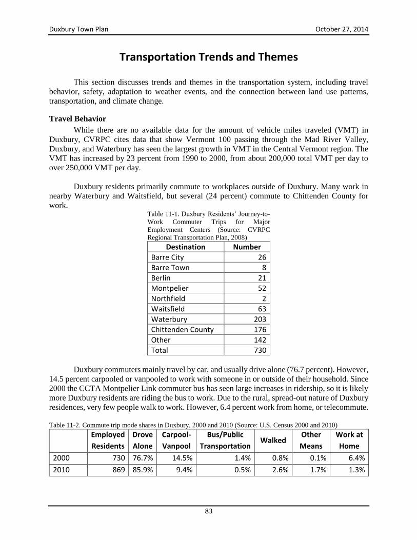
Duxbury Town Plan October 27, 2014
83
Transportation Trends and Themes
This section discusses trends and themes in the transportation system, including travel
behavior, safety, adaptation to weather events, and the connection between land use patterns,
transportation, and climate change.
Travel Behavior
While there are no available data for the amount of vehicle miles traveled (VMT) in
Duxbury, CVRPC cites data that show Vermont 100 passing through the Mad River Valley,
Duxbury, and Waterbury has seen the largest growth in VMT in the Central Vermont region. The
VMT has increased by 23 percent from 1990 to 2000, from about 200,000 total VMT per day to
over 250,000 VMT per day.
Duxbury residents primarily commute to workplaces outside of Duxbury. Many work in
nearby Waterbury and Waitsfield, but several (24 percent) commute to Chittenden County for
work. Table 11-1. Duxbury Residents’ Journey-to-
Work Commuter Trips for Major
Employment Centers (Source: CVRPC
Regional Transportation Plan, 2008)
Destination Number
Barre City 26
Barre Town 8
Berlin 21
Montpelier 52
Northfield 2
Waitsfield 63
Waterbury 203
Chittenden County 176
Other 142
Total 730
Duxbury commuters mainly travel by car, and usually drive alone (76.7 percent). However,
14.5 percent carpooled or vanpooled to work with someone in or outside of their household. Since
2000 the CCTA Montpelier Link commuter bus has seen large increases in ridership, so it is likely
more Duxbury residents are riding the bus to work. Due to the rural, spread-out nature of Duxbury
residences, very few people walk to work. However, 6.4 percent work from home, or telecommute. Table 11-2. Commute trip mode shares in Duxbury, 2000 and 2010 (Source: U.S. Census 2000 and 2010)
Employed
Residents
Drove
Alone
Carpool-
Vanpool
Bus/Public
Transportation Walked
Other
Means
Work at
Home
2000 730 76.7% 14.5% 1.4% 0.8% 0.1% 6.4%
2010 869 85.9% 9.4% 0.5% 2.6% 1.7% 1.3%
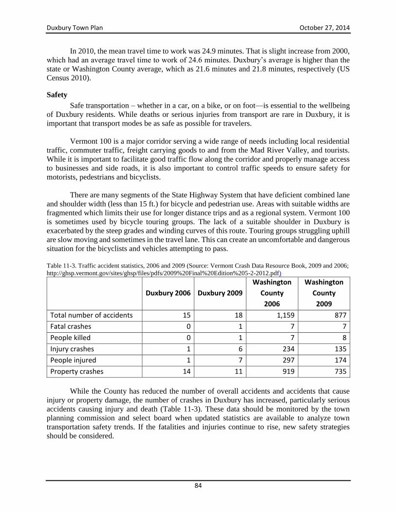
Duxbury Town Plan October 27, 2014
84
In 2010, the mean travel time to work was 24.9 minutes. That is slight increase from 2000,
which had an average travel time to work of 24.6 minutes. Duxbury’s average is higher than the
state or Washington County average, which as 21.6 minutes and 21.8 minutes, respectively (US
Census 2010).
Safety
Safe transportation – whether in a car, on a bike, or on foot—is essential to the wellbeing
of Duxbury residents. While deaths or serious injuries from transport are rare in Duxbury, it is
important that transport modes be as safe as possible for travelers.
Vermont 100 is a major corridor serving a wide range of needs including local residential
traffic, commuter traffic, freight carrying goods to and from the Mad River Valley, and tourists.
While it is important to facilitate good traffic flow along the corridor and properly manage access
to businesses and side roads, it is also important to control traffic speeds to ensure safety for
motorists, pedestrians and bicyclists.
There are many segments of the State Highway System that have deficient combined lane
and shoulder width (less than 15 ft.) for bicycle and pedestrian use. Areas with suitable widths are
fragmented which limits their use for longer distance trips and as a regional system. Vermont 100
is sometimes used by bicycle touring groups. The lack of a suitable shoulder in Duxbury is
exacerbated by the steep grades and winding curves of this route. Touring groups struggling uphill
are slow moving and sometimes in the travel lane. This can create an uncomfortable and dangerous
situation for the bicyclists and vehicles attempting to pass.
Table 11-3. Traffic accident statistics, 2006 and 2009 (Source: Vermont Crash Data Resource Book, 2009 and 2006;
http://ghsp.vermont.gov/sites/ghsp/files/pdfs/2009%20Final%20Edition%205-2-2012.pdf)
Duxbury 2006 Duxbury 2009
Washington
County
2006
Washington
County
2009
Total number of accidents 15 18 1,159 877
Fatal crashes 0 1 7 7
People killed 0 1 7 8
Injury crashes 1 6 234 135
People injured 1 7 297 174
Property crashes 14 11 919 735
While the County has reduced the number of overall accidents and accidents that cause
injury or property damage, the number of crashes in Duxbury has increased, particularly serious
accidents causing injury and death (Table 11-3). These data should be monitored by the town
planning commission and select board when updated statistics are available to analyze town
transportation safety trends. If the fatalities and injuries continue to rise, new safety strategies
should be considered.
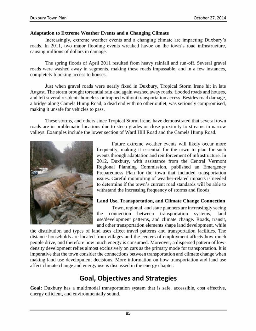
Duxbury Town Plan October 27, 2014
85
Adaptation to Extreme Weather Events and a Changing Climate
Increasingly, extreme weather events and a changing climate are impacting Duxbury’s
roads. In 2011, two major flooding events wreaked havoc on the town’s road infrastructure,
causing millions of dollars in damage.
The spring floods of April 2011 resulted from heavy rainfall and run-off. Several gravel
roads were washed away in segments, making these roads impassable, and in a few instances,
completely blocking access to houses.
Just when gravel roads were nearly fixed in Duxbury, Tropical Storm Irene hit in late
August. The storm brought torrential rain and again washed away roads, flooded roads and houses,
and left several residents homeless or trapped without transportation access. Besides road damage,
a bridge along Camels Hump Road, a dead end with no other outlet, was seriously compromised,
making it unsafe for vehicles to pass.
These storms, and others since Tropical Storm Irene, have demonstrated that several town
roads are in problematic locations due to steep grades or close proximity to streams in narrow
valleys. Examples include the lower section of Ward Hill Road and the Camels Hump Road.
Future extreme weather events will likely occur more
frequently, making it essential for the town to plan for such
events through adaptation and reinforcement of infrastructure. In
2012, Duxbury, with assistance from the Central Vermont
Regional Planning Commission, published an Emergency
Preparedness Plan for the town that included transportation
issues. Careful monitoring of weather-related impacts is needed
to determine if the town’s current road standards will be able to
withstand the increasing frequency of storms and floods.
Land Use, Transportation, and Climate Change Connection
Town, regional, and state planners are increasingly seeing
the connection between transportation systems, land
use/development patterns, and climate change. Roads, transit,
and other transportation elements shape land development, while
the distribution and types of land uses affect travel patterns and transportation facilities. The
distance households are located from villages and the centers of employment affects how much
people drive, and therefore how much energy is consumed. Moreover, a dispersed pattern of low-
density development relies almost exclusively on cars as the primary mode for transportation. It is
imperative that the town consider the connections between transportation and climate change when
making land use development decisions. More information on how transportation and land use
affect climate change and energy use is discussed in the energy chapter.
Goal, Objectives and Strategies Goal: Duxbury has a multimodal transportation system that is safe, accessible, cost effective,
energy efficient, and environmentally sound.
Duxbury Town Plan October 27, 2014
86
Objectives
Ensure a safe transportation system.
Promote cost effective transportation systems that consider the full life cycle costs.
Support transportation alternatives such as public transportation and carpooling that
promote access to transport and reduce environmental impacts.
Strategies
Minimize tree removal along town roads, consistent with highway safety requirements.
Support attendance in the highly-regarded Better Back Roads workshop by the town road
crew.
Cooperate with neighboring towns in seeking solutions to common problems, such as
traffic and safety problems at the intersection of Vermont 100 and U.S. 2 in North
Moretown.
Preserve all stone walls along town roads.
Stabilize roadside banks, where necessary, by reseeding.
Seek ways to prevent the construction of road systems under the guise of forestry, or
timber harvesting, as a prelude to development.
Develop sidewalks from the intersection of Vermont 100 and U.S. 2 (in Moretown) to
Main St. in Duxbury and Crossett Brook Middle School.
Segregate bicycle lanes from the highway as much as possible.
Identify a route for a bike/ped path on River Road between Winooski Street Bridge and
Duxbury Main St.
Assess possible locations for commuter (car pool) parking lots.
Consider combining school bus transport with rural transport as done on many urban
areas.
Maintain and improve on the Town’s road network systems and resources that meet the
need for local and through movement of people and goods.
Coordinate residential development with road development to assure new residents access
to services while judiciously limiting road development. New roads should be constructed
to a minimum Class III at the expense of the builder, and deeded to the town.
Construct any new or upgraded roads to current town road standards and continually
monitor the town road standards to examine whether the roads are resilient in the face of
more frequent and intense storm events.
Develop policies to prevent land use and development activity from adversely impacting
traffic safety and the condition of town roads and rights-of-way.
Review land use regulations, including zoning and new subdivision regulations, for
opportunities to incorporate best practices for access management as recommended by
VTrans.
Maintain current legal trail access throughout the town.
Require on-site circulation of traffic for any business locating on Route 100, thus
eliminating the need for large trucks to back into a business.
Consider traffic calming measures for the stretch of Vermont 100 between Harwood
Union H.S. south to the intersection of Ward Hill Road and between the intersection of
U.S. Route 2 and Vermont 100 and Crossett Hill Road.
Require shared driveways wherever possible.
Duxbury Town Plan October 27, 2014
87
Minimize the number of curb cuts allowed during the site plan review of multi-home
developments and subdivisions and condition the approvals accordingly.
Retain the traffic flow efficiency of Vermont 100 as a valuable interregional travel route,
while maintaining its scenic qualities.
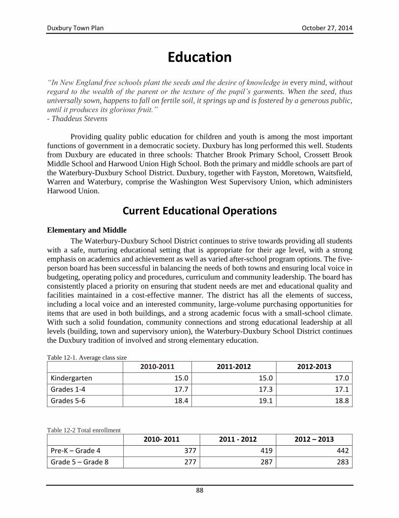
Duxbury Town Plan October 27, 2014
88
Education
“In New England free schools plant the seeds and the desire of knowledge in every mind, without
regard to the wealth of the parent or the texture of the pupil’s garments. When the seed, thus
universally sown, happens to fall on fertile soil, it springs up and is fostered by a generous public,
until it produces its glorious fruit.”
- Thaddeus Stevens
Providing quality public education for children and youth is among the most important
functions of government in a democratic society. Duxbury has long performed this well. Students
from Duxbury are educated in three schools: Thatcher Brook Primary School, Crossett Brook
Middle School and Harwood Union High School. Both the primary and middle schools are part of
the Waterbury-Duxbury School District. Duxbury, together with Fayston, Moretown, Waitsfield,
Warren and Waterbury, comprise the Washington West Supervisory Union, which administers
Harwood Union.
Current Educational Operations
Elementary and Middle
The Waterbury-Duxbury School District continues to strive towards providing all students
with a safe, nurturing educational setting that is appropriate for their age level, with a strong
emphasis on academics and achievement as well as varied after-school program options. The five-
person board has been successful in balancing the needs of both towns and ensuring local voice in
budgeting, operating policy and procedures, curriculum and community leadership. The board has
consistently placed a priority on ensuring that student needs are met and educational quality and
facilities maintained in a cost-effective manner. The district has all the elements of success,
including a local voice and an interested community, large-volume purchasing opportunities for
items that are used in both buildings, and a strong academic focus with a small-school climate.
With such a solid foundation, community connections and strong educational leadership at all
levels (building, town and supervisory union), the Waterbury-Duxbury School District continues
the Duxbury tradition of involved and strong elementary education.
Table 12-1. Average class size
2010-2011 2011-2012 2012-2013
Kindergarten 15.0 15.0 17.0
Grades 1-4 17.7 17.3 17.1
Grades 5-6 18.4 19.1 18.8
Table 12-2 Total enrollment
2010- 2011 2011 - 2012 2012 – 2013
Pre-K – Grade 4 377 419 442
Grade 5 – Grade 8 277 287 283
Duxbury Town Plan October 27, 2014
89
Crossett Brook Middle School also provides community uses, such as space for Duxbury’s
town meeting and supervised community recreational events. The school is welcoming to the
community and is fortunate to have an active parent-teacher organization.
High School Education
Harwood Union has a total student enrollment of 578 students. The High School (grades
9-12) serves students from Duxbury, Fayston, Moretown, Waitsfield, Warren, and Waterbury. A
single board, comprised of representatives from all six sending communities, governs all decisions
concerning Harwood High School and makes decisions concerning the combined middle/high
school budget. Costs are allocated to communities based on the number of students they have at
the school. Harwood Union’s comprehensive curriculum is designed to prepare students for
success regardless of the path they choose to pursue beyond high school. Of the 162 seniors who
graduated in the Class of 2005, 69 percent are continuing their education at either a four year
college or other post-secondary school. Thirteen percent are going directly to work and 4 percent
of the class joined the military. The remainder was undecided at the time of graduation. Harwood
is continuing to raise the academic expectations of all students in response to the increasing
demands of our society. Under the leadership of the Washington West Supervisory Union district
office, educators from all schools in the district are working to align the pre-K-12 curriculum. The
overall objective is to ensure that the curriculum is rich, challenging, and viable for all students
and that student assessments are in place that will inform instruction. Harwood’s overall
enrollment is declining and is projected to do so for the next eight years.
Harwood offers vocational educational choices through the Barre Technical Center. The
Barre Technical Center also offers adult classes in the evening.
Child Care
Quality child care is a critical community need. While school is an essential part of a child’s
development, the time many families have to spend at work prevents them from being available
immediately after or before school hours. This is further demonstrated with children who are too
young for school. Families need affordable, high quality, and convenient child care options in
order to allow adults to participate in their jobs while providing a safe and active place for their
children to stay and learn. According to research conducted by Child Care Resource (CCR) in
2005, 74 percent of children between the ages of 0-12 had all parents in the labor force. While this
high percentage does not mean that all families need child care services provided by non-family
members, it does indicate that a high number of families may be using, or searching for, child care
facilities.
The Town of Duxbury is fortunate to have two licensed day care facilities that are
nationally accredited: The Children’s Early Learning Space in the former Duxbury Elementary
School and the Children’s Early Learning Ladder, also located on Main Street. In addition,
Duxbury has two registered home-based day centers. There may be additional providers who are
not required to register with the state and, therefore, not listed in the child care data base. Thatcher
Brook Primary is the host of the YMCA’s Live Y’ers program, which provides after-school care
and activities for school-aged children. Having after-school programs is one way to help support
the community and address the childcare issue of supervision of school-aged children. The town
needs to support and create resources for residents who have, or are expecting, children who are
Duxbury Town Plan October 27, 2014
90
not in school and need full or part-day services. Children are Duxbury’s future and their health and
well-being are essential to a balanced community. It is important to have a diverse choice of
childcare facilities for residents which meet the needs of the community and allow for adults to
participate in the local economy as they see fit. High quality child care impacts the local economy
by allowing a job source for workers and an opportunity for residents to attend work, but more
importantly, child care assists in the development of Duxbury’s next generation.
Goal, Objectives and Strategies Goal: High quality, broad-based educational services ensure the full realization of the abilities of
all Duxbury residents through early child care and the public school system and other public and
private educational programs.
Objectives
Maintain a quality school system for both present and future residents that is essential to
the quality of life, and provides Duxbury with a community focus and sense of pride.
Provide appropriate facilities and infrastructure for a variety of academic, athletic, social,
cultural and community activities.
Provide adequate funding, using all available sources, to achieve the highest possible
standards.
Broaden access to educational and vocational training opportunities.
Support creativity, innovation and imagination when planning for future educational
needs of Duxbury’s student population and to encourage efforts which strengthen the
important role schools play in fostering community and a shared purpose among local
residents.
Provide the community with a sense of ownership and appreciation for schools as
resource.
Ensure that both motorized and pedestrian access to school is safe and convenient.
Strategies
Promote the use of the schools for adult education and other community activities.
Encourage continued active participation on district school boards in order to promote the
interest of Duxbury’s students, parents and taxpayers.
Develop Safe Routes To School through partnerships among schools, local
municipalities, parents and other community groups.
Support the development and operation of child care facilities within the town.
Support use of town lands for broad-based educational experiences.
Duxbury Town Plan October 27, 2014
91
Community Utilities, Facilities and Services
Cemeteries
Duxbury has a total of ten cemeteries, five of which are in use and five of which are historic
cemeteries closed to further burials. In 1997 a group of people from Waterbury and Duxbury
decided it would be “fun to document and publish a listing of all the gravestones” in the cemeteries
of these two towns. In December 2000 the “Waterbury Genealogy Quest” published its findings
in a superb volume of more than 300 pages. A copy is available at the town clerk’s office and will
be an invaluable resource for people tracing their roots in the years ahead, particularly as the
gravestones in our older cemeteries become harder to decipher with each passing year. A list
follows of the cemeteries in Duxbury.
Old South Duxbury Cemetery is on Vermont 100 near the Dowsville Bridge, with access
from DeLong Road. This is a private cemetery, maintained by the South Duxbury
Cemetery Association. Dates of death on the gravestones in this cemetery range from 1823
to 1877.
South Duxbury Cemetery, on Vermont 100 next to Harwood Union High School, is still in
use but purchase of plots in this cemetery is limited to residents of South Duxbury or those
having family members already buried there. The earliest burial date on a gravestone is
1854. This cemetery is owned and maintained by the South Duxbury Cemetery
Association.
The Phillips Cemetery on Vermont 100 is still in use, and is owned and maintained by the
Town of Duxbury. The earliest burial date on a gravestone is 1826.
Crossett Hill Cemetery is located in a pine grove off Hayes Road on Crossett Hill. Dates
of death on the fourteen gravestones in this cemetery range from 1853 to 1875. The
Cemetery Commission undertook an ambitious research and restoration project in
conjunction with UVM archeologists in 2004. They restored the cemetery grounds, in
which nineteen individuals, mostly members of Roswell Crossett’s family are buried.
The Sprague Cemetery on Crossett Hill Road contains the gravestones of two people who
died about 1850.
Holy Cross Cemetery at Duxbury Corner is maintained by the Catholic Parish in Waterbury
and is still in use. The earliest date of death shown on a gravestone in this cemetery is 1861.
Duxbury Corner Cemetery adjoins Holy Cross Cemetery, is still in use and is maintained
by the Duxbury Corner Association. The earliest date of death on a gravestone here in
1805.
Graves Cemetery, on River Road, is still in use and maintained by the Graves Cemetery
Association. Earliest date of death on a gravestone in this cemetery is 1815.
Landon/Hayden Cemetery on Scrabble Hill in North Duxbury has sixteen graves dating
from 1829 to 1886.
Duxbury Town Plan October 27, 2014
92
The Monroe Cemetery at the foot of Camels Hump contains the gravesites of Professor
Monroe (who was instrumental in laying out many of the hiking trails on Camels Hump),
his sister and his dogs,. This cemetery is near the parking lot for Camels Hump State Park
and is maintained by the Park rangers.
Duxbury Land Trust
The Duxbury Land Trust (DLT) is a private, non-profit organization that was founded in
1994 by a group of Duxbury residents. The Trust’s mission is to “preserve and protect the
natural, cultural, aesthetic and recreational resources” of Duxbury. As an organization devoted
to conservation, the Land Trust can play an important role in helping the town meet the
conservation goals outlined in the Town Plan.
While all of Duxbury’s natural and cultural resources are important, the Land Trust
focuses on identifying and conserving natural areas along river, stream, and mountain corridors.
By protecting riparian zones and forested mountain areas, the Trust can help maintain the
benefits provided by the town’s healthy forests and clean waterways.
The DLT takes a voluntary and collaborative approach in working with the town, with
landowners, and with its partner organizations and neighboring communities. It achieves its
objectives primarily through conservation easements, but also through owning land when
appropriate. Since 1995 the Land Trust has owned an 11-acre parcel on Ridley Brook in North
Duxbury. An additional five acre parcel with significant Ridley Brook frontage was donated to
DLT in 2004. In 2011, the Trust purchased thirteen acres adjacent to the 5-acre parcel on Ridley
Brook. In 1999 DLT acquired a conservation easement donation on a 30-acre Crossett Hill
property. In 2004, the State conveyed a conservation easement on 73 acres of the Crossett Hill
section of the former State Farm. Two additional State Farm easements were conveyed in 2014.
The Land Trust has now conserved more than 300 acres in Duxbury.
The Land Trust is supported through memberships, donations, and fundraising. A nine-
member board of volunteer trustees oversees the activities of the Trust. DLT complies with the
Standards and Practices of the Land Trust Alliance. In addition to conserving natural areas, the
trustees publish an annual newsletter, hold an annual membership meeting, and have coordinated
Duxbury’s Green Up Day since 1996.
Fire Protection
Currently fire protection for residents in the northern section of Duxbury is provided by
the Waterbury Fire Department, while the Moretown Fire Department provides protection for
Duxbury residents living south of the northern end of the Turner Hill Road. For 2014, the Town
has budgeted $102,663 to the Waterbury Fire Department and $3,000 to the Moretown Fire
Department for the annual fire protection contracts. In 2013, the Waterbury Fire Department
responded to 22 calls in Duxbury, including five auto accidents. The Moretown Fire Department
responded to ten calls (five motor vehicle accidents, two structure fires and three fire alarms).
It should also be noted that the installation of ten fire hydrants at the Crossett Brook
Duxbury Town Plan October 27, 2014
93
Middle School provides increased protection for residents in that section of town. There is also a
dry hydrant on River Road in North Duxbury near the bottom of Camels Hump Road.
Both the Waterbury and Moretown Fire Departments are members of the Capital Fire
Mutual Aid System composed of some forty fire departments in Washington, Orange and
Caledonia Counties which are prepared to act cooperatively in case of a major fire. No changes to
the current fire protection policy are anticipated in the immediate future.
Health and Ambulance Services
There are no health services located within the town of Duxbury. The nearest doctors are
in Waterbury and in Waitsfield; town residents use the Central Vermont Medical Center in
Berlin, the Fletcher Allen Hospital complex in Burlington and, to a lesser degree, Copley
Hospital in Morrisville, Gifford Memorial Hospital in Randolph and the Dartmouth-Hitchcock
Hospital in Lebanon, New Hampshire.
The Central Vermont Home Health & Hospice (CVHH&H) in Waterbury provides home
health care to people in Duxbury as well as to residents of twenty-two other central Vermont towns.
This agency is governed by a local voluntary board of directors and is committed to providing
comprehensive, high-quality care to all Central Vermonters who need it, regardless of their ability
to pay. Services offered include skilled and high-tech nursing, home health aide service, physical,
occupational and speech rehabilitation therapies, medical social services, hospice care for the
terminally ill, maternal-child health, and psychiatric nursing. The agency also delivers long-term
care services at home which include homemaker service, attendant care, respite care, and private
duty nursing and aide care.
For the twelve months ending on November 30, 2013, the CVHH&H staff made 972 home
visits to 19 Duxbury patients. Of those, 934 were homecare for patients following an accident,
injury or illness, 17 were hospice visits, and 21 were to provide long-term care. The 2014 Town
budget includes a $1,600 donation to Central Vermont Home Health & Hospice to support these
services.
The Vermont Health Department provides a WIC nutrition program, a Medicaid outreach
program, and the Healthy Babies program. It also supports the Town Health Officer, investigates
cases of infectious disease and offers screening for lead.
Duxbury is also served by the Washington County Mental Health Services based in Berlin.
Ambulance service to residents in the southern section of Duxbury is provided by the Mad
River Valley Ambulance Service in Waitsfield, while residents in the northern part of town use
the Waterbury Ambulance Service. Both ambulance services are supported by a combination of
subscriptions, donations and fees for service.
Duxbury Town Plan October 27, 2014
94
Police
Duxbury looks to the Vermont State Police in Middlesex for police protection. In addition
to serving the town of Duxbury, the Middlesex station provides coverage for fifteen other towns
in Washington County, for three towns in Orange County, and for over 1,000 miles of highways.
The Middlesex station has a maximum of five and as few as two officers on duty each shift. In
addition to responding to emergency calls from the approximately 28,000 residents of central
Vermont, they must also weigh trucks and inspect hazardous cargo, train other law enforcement
officers and assist a variety of federal and state agencies. The Vermont State Police also provide
special teams (search and rescue, crowd control, hostage negotiator, dive team and a K-9 unit) to
all parts of the state.
A Town Constable, elected at Town Meeting each year, responds to calls which do not
require State Police intervention, primarily those involving stray animals. Currently, the Constable
volunteers his services but is reimbursed for mileage expenses when he has to take an animal to
the pound. At Town Meeting the voters also decide whether to elect a Second Constable, whose
primary responsibility is the collection of delinquent property taxes.
The responses to a community questionnaire in 1990 revealed some concern over the
adequacy of police services in our town, which is hardly surprising given the demands placed on
the Middlesex station and the large geographical area it must cover. Therefore, this plan
recommends that the Planning Commission should continue to monitor the adequacy of police
services in Duxbury and urge that the present level of staffing at the Middlesex State Police station
be maintained as a minimum.
The Middlesex State Police Barracks Commander is a member of the Central Vermont
Citizen's Advisory Board (CVCAB). The select boards from each town served by the Middlesex
barracks have an opportunity to have a representative on the board. The CVCAB meets the third
Tuesday of each month at the Central Vermont Medical Center in Berlin.
Recreation
It is doubtful whether anything more reflects the essence of Duxbury and Vermont than a
love of the out-of-doors, a need and a desire to engage in a wide variety of recreational activities.
The most popular forms of recreation in Duxbury are hiking, snowmobiling, hunting and fishing,
cross-country skiing and snowshoeing as well as running, canoeing and bicycling. Most of these
activities are what might be called traditional Vermont sports. Many require scenic surroundings
as well as access to large and relatively remote forest lands.
It is the aim of this Town Plan to ensure that opportunities will continue to exist for these
forms of outdoor recreation so essential to the residents of the town. In this respect, Camels Hump
State Park with its 8,354 acres of woodlands and the mountain’s alpine summit is a resource of
obvious significance, but with 40,000 visitors to the park each year, many local people avoid the
more popular trails on summer weekends. About five miles of the Long Trail, included on the
Vermont Register of Historic Places as the first long-distance hiking trail in the United States,
passes through Duxbury. The DLT owns and offers for public use a popular swimming hole and
picnic spot on Ridley Brook in North Duxbury, while many Duxbury families enjoy the use of the
Duxbury Town Plan October 27, 2014
95
municipal athletic fields and swimming pool in Waterbury. The Cross Vermont Trail follows River
Road from the Winooski Street Bridge to the Bolton town line, a route approved by the Duxbury
Select Board in 2003.
However, it is also clear that the town should not rely exclusively on public lands for
outdoor recreational opportunities. At the present time two-thirds of Duxbury’s forests are in
private ownership and provide a major percentage of our recreational opportunities. It is readily
apparent that Duxbury cannot rely on public lands alone to meet the rising recreational needs of a
growing population, especially since Vermont is attracting ever-larger numbers of out-of-state
visitors and tourists.
For these reasons, it is very important to maintain public access to private forest lands in
Duxbury. It is indeed gratifying that the great majority of our landowners choose not to post their
land, thus increasing recreational opportunities for everyone as well as strengthening the sense of
good neighborliness that already exists.
However, it would be unwise simply to assume that this happy state of affairs will continue
into the indefinite future. On the contrary, every effort should be made to promote a continued
spirit of cooperation between landowners and recreational users of private land. It is recommended
that the Planning Commission, or some other appropriate body, consult with organizations such as
VAST (Vermont Association of Snow Travelers) as to other ways that cooperation between
landowners and recreational users of private land can be maintained and even strengthened. It is
further recommended that Duxbury work cooperatively with Waterbury on the further
development of the recreation path along River Road, and with Moretown to develop a safe bicycle
path to Crossett Brook Middle School.
Wastewater Systems
All residences in Duxbury are served by individual subsurface wastewater disposal
facilities which must conform to the health regulations established in the Zoning Ordinance. These
regulations require that a sewage disposal system must be at least 50 feet from a natural
watercourse and 100 from any drinking water supply; in addition, a subsurface drainage field must
have at least 5 feet to bedrock.
In 2007 legislation requiring a wastewater and potable water supply permit from the State
of Vermont Department of Environmental Conservation prior to the construction of a residential,
commercial or public building went into effect. The wastewater and water supply system must
comply with state standards and must be installed in accordance to a state approved design and
plan. There are some exceptions to this general rule. Further information regarding permit
requirements may be obtained by contacting the Regional Permit Specialist at (802) 476-0195.
Solid Waste and Recycling
Duxbury is a member of the six-town Mad River Solid Waste Alliance. As such, Duxbury
is a participant in the efficient implementation of the Solid Waste Plan that was adopted by the
Alliance towns. Within the Alliance there are two transfer stations (in Waterbury and Waitsfield)
and one landfill (in Moretown). In 2013 the Moretown Landfill was ordered to close by the Agency
Duxbury Town Plan October 27, 2014
96
of Natural Resources. Garbage collection can be arranged at some residential and commercial
locations in Duxbury. Currently, many recyclables are accepted at multiple facilities.
Special programs held during the year by the Alliance provide household hazardous waste
collection.
Duxbury should ensure its active participation in the Alliance by the Select Board
appointing a town representative to serve on the Alliance board. It is also important that Duxbury
residents continue to reduce waste through waste prevention, reuse and recycling, that they reduce
illegal dumping and burning, and that they support the Alliance budget to enable the continuation
of the various special Alliance programs in the six member towns. A number of specific
recommendations as to how this can be done are included in the Goals and Recommendations
section of this Plan.
The Universal Recycling Law (Act 148) was enacted by the Vermont Legislature in 2012.
The law bans recyclable and compostable materials from landfills, with the bans being
implemented incrementally from 2015 to 2020. In addition to ensuring that Duxbury residents
have access to appropriate disposal facilities, it will be necessary for the Town to review its own
operations and adopt recycling procedures so that it compliant with the law.
Telecommunications Towers
In accordance with Federal law, telecommunications facilities must be allowed, at least within
designated zoning districts and subject to review by the Town. Accordingly, the Town adopted a
Telecommunications Ordinance on July 20, 2001. The Ordinance allows the construction of such
facilities in the Timber and Wildlife Management, Forest-Recreation, Village and Rural
Agricultural I or II Districts. The Ordinance also sets forth a number of conditions and prohibitions:
Co-location and shared use of the tower by additional users on reasonable terms is required.
The height and siting of the tower must be restricted so that it will blend into the
surrounding environment to the extent feasible and without illumination. In addition, the
latest stealth technology (for camouflaging the tower in the most appropriate way in the
neighborhood in which it is located) shall be required, and any electricity shall be brought
in underground.
There are setbacks from wetlands, historic districts or structures, rivers, scenic roads,
schools, and residences.
There is a prohibition against placement of any facility in the habitat of any state listed rare
or endangered species.
Abandoned or unused towers must be removed.
Town Properties
The Town of Duxbury owns three properties:
The Town offices and the Town garage occupy a five-acre parcel at the northern
intersection of the Crossett Hill Road and Vermont 100. The quantity of Town records that
must be kept in the vault has increased greatly in recent years, and the capacity of the vault
Duxbury Town Plan October 27, 2014
97
will be reached within the next decade. A spacious and modern town garage was built in
2005 that includes a comfortable meeting room for town boards.
The gravel pit on the former State Farm property was purchased by the Town in 1998 so
that the Town would have a convenient and more economical source of gravel for road
maintenance. This 37.7 acre parcel is on the hilltop just south of Crossett Brook School
and has excellent access from Vermont 100. This gravel pit is nearly exhausted but could
provide an excellent site for either light commercial/industrial development or for
residential development. In either case, the zoning ordinance would have to be amended,
and the Select Board and the planning commission should consider their options fully
before making a decision.
A one-acre parcel with a picnic pavilion on Crossett Hill, which was donated to the Town
in 1989 by the Crossett Hill Association.
The former Duxbury Elementary School property located on Main Street was purchased
from the Town by Doug and Katherine Boyden in 2004. The school has been completely
restored and is an attractive focal point in Duxbury Corner. The Children’s Space continues
to occupy the lower floor and the rest of the building contains apartments.
Water Supply
Natural springs and drilled wells provide water in most sections of town. Therefore, the
importance to the community of abundant and pure groundwater cannot be overstated. Any land
use which pollutes, restricts or otherwise limits the natural flow of water within an aquifer recharge
area will, of course, affect ground water quality. Another threat to the purity of our groundwater
could come from a malfunctioning septic system releasing pollutants into the ground.
For many years the residents of Duxbury Corner, however, had been served by a small
private water company, and the quality of that water was frequently unsatisfactory. In 1997 the
Waterbury municipal water lines were extended across the Winooski River to the Main Street area
of Duxbury, to the new Crossett Brook Middle School and to the Duxbury Town Offices.
Goal, Objectives and Strategies Goal: Facilities, services, and utilities are safe, practical, efficient, reliable, affordable and
available.
Objectives
Provide emergency services to Duxbury residents at a level adequate to protect public
health and safety.
Assure public health is protected through adequate waste disposal programs and systems.
Improve residents’ quality of life through quality recreational opportunities.
Strategies
Manage town cemeteries, and expand if needed, to ensure that burial opportunities will
exist for the foreseeable future, and to ensure that as undeveloped properties become
Duxbury Town Plan October 27, 2014
98
limited, town cemeteries will continue to serve as an important cultural focus of the
community.
Continue membership in the Mad River Valley-Waterbury Solid Waste Alliance, and
support the Alliance’s efforts to reduce waste generation and provide environmentally
sound waste disposal opportunities.
Collaborate with the Agency of Natural Resources and other parties to prevent illegal
dumping and burning of waste and support clean-up of such sites as soon as they are
discovered.
Plan future growth of facilities and services to avoid unreasonable burdens on the town’s
taxpayers. Cost considerations could include at a minimum: rate of change in the property
tax rate, financial and personnel resources to maintain future utilities, cost/benefit of
reliability, cost/benefit of efficiency.
Develop plans to share services and facilities with neighboring towns.
Require developers to fund the proportional cost of facilities needed to accommodate new
development if new or expanded public utilities are required to accommodate new
development are not available or planned, unless the town determines that the proposed
development will provide community benefits which outweigh or offset the cost of the
required facilities.
Recognize the importance of making the most effective and efficient use of existing
services, structures and facilities and utilities before expanding capacity or constructing
new buildings or facilities.
Maintain town funded emergency services, including fire and police protection, in a
manner that continues their current high level of service as the community grows.
Encourage the efforts of VAST to provide an integrated network of winter recreation trails
in a manner that does not adversely impact neighboring homeowners and the natural
environment, and allow VAST trail use of Class 4 roads on a case-by-case basis to avoid
conflict with other users of the road and neighboring residential properties.
Use the Duxbury Telecommunications Ordinance to guide the expansion or development
of wireless telecommunications facilities
Support the expansion of telecommunication service in the community, including
broadband Internet access, and efforts to ensure greater public access through municipal
use of the world wide web to disseminate information.
Work with and provide support, to the extent practical, to community arts and cultural
organizations.
Encourage the creation of recreation facilities that foster fitness and well-being (e.g.,
fitness courses)
Coordinate the provision of facilities and services with the land use and development
goals and policies outlined in this plan, including the reinforcement of growth centers.
Duxbury Town Plan October 27, 2014
99
Energy
Energy Overview Energy is a the basis of our economy. Almost everything we do requires energy of one
form or another. We use energy to heat and power our homes and businesses, and to transport
people, goods and services; however, the energy usually comes from finite reserves in distant
locations which are not under the control of the local community.
Vermont has the lowest total energy consumption and fossil fuel emission levels of any
state in the nation. This is impressive, but not unexpected for a state with a small population and
limited industry. The primary sources of energy in Vermont communities are fossil fuels (primarily
oil and gas), nuclear generated electricity, locally generated and imported hydroelectricity, and
biomass (wood). To a minor extent renewable energy sources such as solar and wind are also
utilized.
In Vermont, fossil fuels are the primary source of energy, accounting for 75 percent of all
energy use. Our dependency on fossil fuels contributes to the accumulation of atmospheric
greenhouse gases that are driving climate change. A continued dependency on fossil fuels over the
long term will ultimately create severe environmental problems and the potential for economic
hardships when supplies dwindle or are cut off. Local residents and business of limited means are
especially vulnerable to huge price swings and supply shortages.
All fossil fuels are produced outside our region, so most of the money spent on these energy
sources is exported from our local economy. Our economic system is so tied to the availability of
fossil fuels that even modest increases in price can lead to high inflation, lagging economic growth
and monetary instability. The increased production of natural gas in the U.S. and Canada is
providing some relief from high energy costs, but that relief is likely to be short-lived.
Since transportation is almost entirely fossil fuel based, this sector is Vermont’s single
largest contributor to greenhouse gases. According to the Vermont Comprehensive Energy Plan,
the transportation sector accounts for over 45 percent of total energy demand and approximately
two-thirds of all fossil fuel use in Vermont. As a result, many Vermonters spend more on driving
than they do on health care, education, or food.
Local energy sources (wood, wind, solar, and hydropower), could appear to offer distinct
advantages over imported energy. For every dollar spent on fuel wood, only about 20 percent of
that dollar leaves the local community. The rest remains in our region, which helps to create local
jobs and support our local economy. Conversely, for every dollar spent on imported energy, 85
percent of that dollar flows out of the community. Another point to consider is the long-term
availability of local energy sources. Once developed, these resources are not subject to politically
induced shortages, nor to interruptions in the distribution network. In contrast, foreign fuel sources
are insecure and unstable, subject to huge price swings, potential terrorist attack and supply
shortages beyond our control.
Duxbury Town Plan October 27, 2014
100
Nonetheless, these local sources of energy all have definite downsides. Development of
commercial-scale windpower requires extensive development of roads and turbine sites on
ridgelines, with resulting impacts on wildlife habitat, hydrology and water quality. Large solar
projects involve large tracts of land, often removing prime agricultural land from production or
impacting wetlands. Hydropower projects of all sizes require infrastructure on rivers and streams
that can disrupt natural river processes and increase flood risk. Wood harvesting for fuel must be
carefully done to avoid depleting forest resources and production of higher value forest products.
While in-state renewable energy sources can contribute to Vermont’s overall energy
supply, they are unlikely to provide a significant part of our future current electricity demand.
Likewise, energy efficiency and conservation initiatives can help reduce power consumption,
especially during peak periods of demand, but at current levels of engagement cannot significantly
reduce overall consumption.
Land Use and Energy While the energy picture often appears abstract and beyond the influence of individual
communities, local planning can play a positive role in guiding energy decisions. By promoting
concentrated development patterns, improving transportation options and encouraging
conservation, Duxbury can reduce its dependence on fossil fuels and other imported energy
sources.
It is imperative that we, as a community, encourage energy efficiency and conservation
through conscientious siting and design of structures whenever economically feasible. Townwide
development patterns will affect energy consumption. Sprawling growth patterns tend to result in
more and longer vehicle trips, while compact growth can have the opposite effect. Attention to
these issues is economically rewarding to homeowners as well as society, as our vulnerability to
the volatility of the energy market is lessened.
Renewable Energy Renewable energy resources found in Duxbury include biomass (wood), hydropower, wind
and solar. The Town recognizes that renewable energy sources should have a role in the town’s
energy future, but that that development and use of those resources has negative impacts on the
town’s natural, cultural and scenic resources, which must be protected. Rising fuel prices, new
technologies, and the ability of utility customers with small scale renewable energy systems to sell
excess power generated back to the utility may promote increased use of renewable sources.
Biomass (wood) is Duxbury’s most abundant, local energy source. For most of Duxbury’s
history, wood was the primary source of heating one’s home. More recently, Harwood Union High
School has installed a wood chip heating system. Duxbury has a large amount of forested land,
which, guided by effective land use regulations and sound forest stewardship plans, could meet a
portion of the town’s and region’s energy demand. Wood should be harvested sustainably and used
in high efficiency systems.
Twenty-one percent of Vermont's net electricity generation in 2011 was from conventional
hydroelectric power. Green Mountain Power currently has a hydroelectric plant in Duxbury on the
Winooski River. Opportunities to further develop hydroelectric power are very limited due to the
Duxbury Town Plan October 27, 2014
101
relatively small streams, need to protect aquatic resources, and goal to limit further encroachments
in stream corridors. Any new projects must avoid development of new infrastructure in stream
corridors and meet state standards for protection of streamflow.
The contribution of solar energy to Duxbury’s total energy supply is increasing. Officials
in Waterbury and Duxbury launched a year-long effort to double the number of solar-power
projects in the town. Most of these projects are small (home-scale), net-metered photovoltaic
installations or solar hot water. In 2013, estimates were that 52 solar hot water and electricity
generating systems were already in use in the two towns. Examples of larger projects include
Thatcher Brook Primary School and Crossett Brook Middle School, which have made significant
investments in solar panels with the help of the Local Energy Action Partnership (LEAP).
Wind power, like hydro and solar power, is a low carbon-emission energy source. Several
years ago, the Vermont Department of Public Service conducted a statewide wind resource
assessment, including the mapping of Vermont’s most favorable wind resource areas. Besides the
spine of Camels Hump, Duxbury does not have favorable wind locations, but there may be sites
that are suitable for small (less than 1 MW), single turbine installations.
Given the importance this plan places on protection of the town’s upper elevation areas,
development of all free-standing solar and all wind energy generation structures in the Forest
Reserve District above 1,700 feet elevation should be prohibited. (Such development is already
prohibited in the Ecological Reserve District.) Large commercial solar projects may be appropriate
in lower elevation areas, but their impact on prime agricultural land and the scenic character of the
town must be taken into account, with protection of these natural resources paramount. Multi-
turbine, multi-megawatt commercial wind energy projects should not be constructed in any
district.
Goal, Objectives and Strategies
Goal: Duxbury residents have access to energy resources at reasonable costs while supporting
resource management in an environmentally sound and sustainable manner.
Objectives
Reduce our dependence on nonrenewable and imported energy sources.
Reduce the rate of increase in energy consumption through conservation and improved
energy efficiency.
Promote cost effective development of local, community-scale renewable energy
resources in an environmentally sound and sustainable manner.
Reduce energy consumption in all Town and school buildings and operations.
Strategies
Support public education and awareness programs aimed at reducing energy consumption
and using energy more efficiently.
Encourage, through transportation policies, opportunities for walking, cycling, carpooling
and other energy efficient alternatives.
Duxbury Town Plan October 27, 2014
102
Encourage land use and conservation policies which promote sound forest management,
in order to maintain a local fuel-wood source,
Encourage and support the use of locally-produced, appropriately sized and sited energy
sources such as wood, solar and wind.
Engage in long-range planning for the sustainable use and acquisition of energy.
Establish land use policies which encourage concentrated growth and land-use patterns
that will result in conservation and efficient use of energy.
Apply energy and efficiency standards to the operation of municipal facilities and
departments, and in any future municipal construction.
Require that developers quantify and evaluate the energy impact of all major development
proposals.
Strive to obtain the cooperation of the builders of new homes to comply with Vermont
energy standards and to complete and file with the Town a Vermont Residential Building
Energy Standards Certificate.
Duxbury Town Plan October 27, 2014
103
Maps
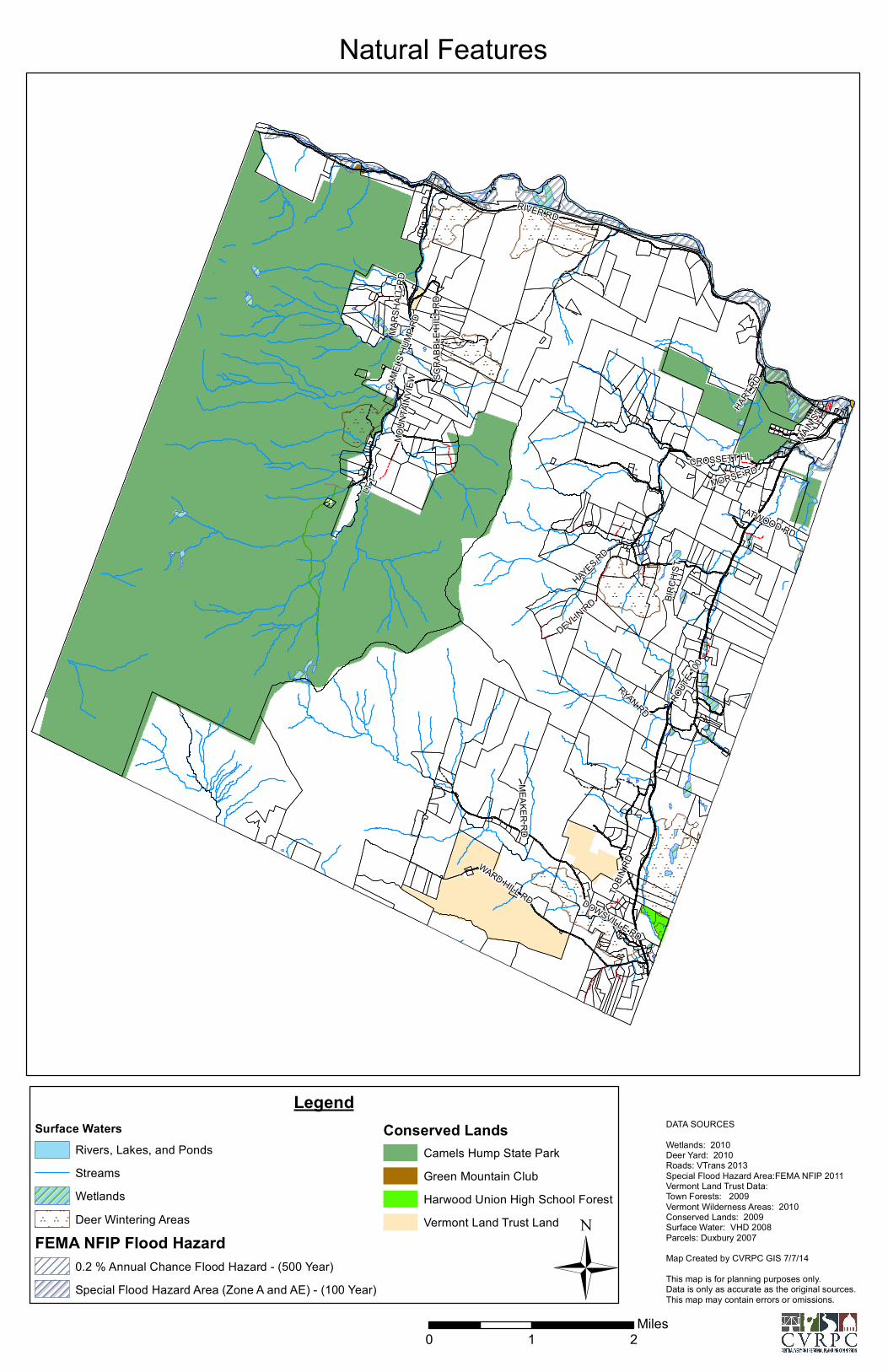
RIVER RD
ROUT
E 100
CAME
LS H
UMP R
D
WARD HILL RD DOWSVILLE RD
DEVLIN RD
CROSSETT HL
MARS
HALL
RD
SCRA
BBLE
HILL
RD
HAYES RD
MOUN
TAIN
VIEW
HART
RD
MAIN ST
RYAN RD
MORSE RD
MEAKER RD
BIRCH
ST
LT 1
ATWOOD RD
TOBIN
RD
LegendSurface Waters
Rivers, Lakes, and PondsStreamsWetlandsDeer Wintering Areas
FEMA NFIP Flood Hazard0.2 % Annual Chance Flood Hazard - (500 Year)Special Flood Hazard Area (Zone A and AE) - (100 Year)
Conserved LandsCamels Hump State ParkGreen Mountain ClubHarwood Union High School ForestVermont Land Trust Land
Natural Features
DATA SOURCESWetlands: 2010Deer Yard: 2010Roads: VTrans 2013Special Flood Hazard Area:FEMA NFIP 2011Vermont Land Trust Data:Town Forests: 2009Vermont Wilderness Areas: 2010Conserved Lands: 2009Surface Water: VHD 2008Parcels: Duxbury 2007Map Created by CVRPC GIS 7/7/14This map is for planning purposes only.Data is only as accurate as the original sources.This map may contain errors or omissions.Ü
0 1 2Miles
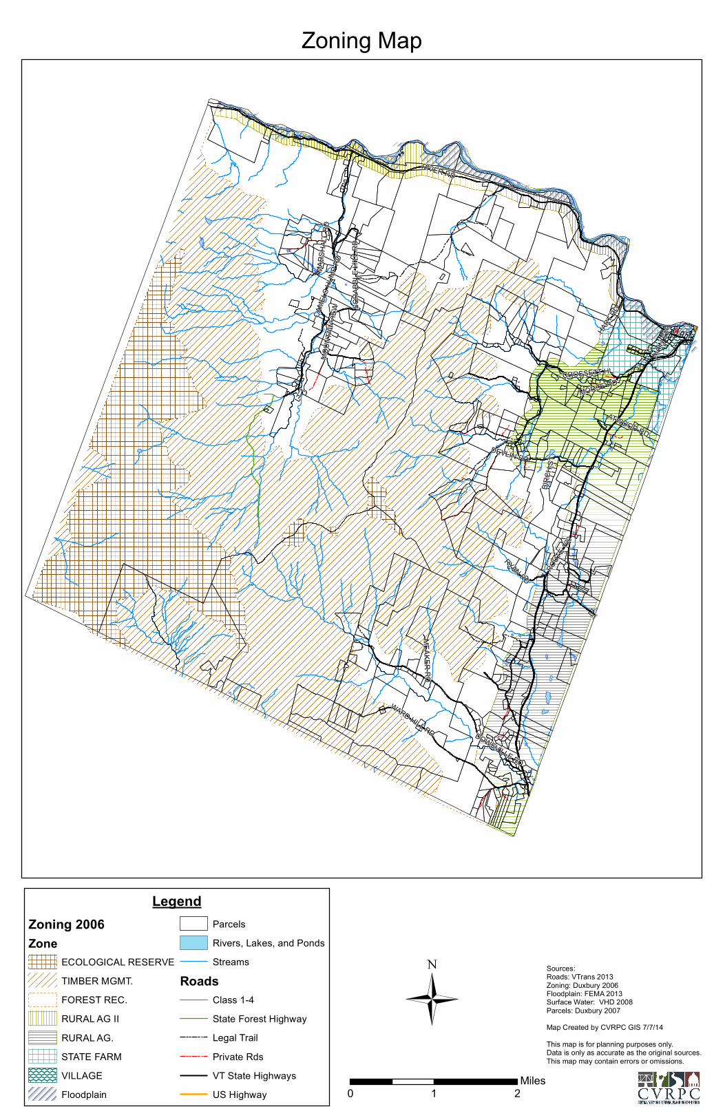
RIVER RD
ROUT
E 100
CAME
LS H
UMP R
D
WARD HILL RD DOWSVILLE RD
DEVLIN RD
CROSSETT HL
MARS
HALL
RD
SCRA
BBLE
HILL
RD
MOUN
TAIN
VIEW
HART R
D
MAIN
ST
RYAN RD
MORSE RD
MEAKER RD
BIRCH
ST
LT 1
ATWOOD RD
LegendZoning 2006Zone
ECOLOGICAL RESERVETIMBER MGMT.FOREST REC.RURAL AG IIRURAL AG.STATE FARMVILLAGEFloodplain
ParcelsRivers, Lakes, and PondsStreams
RoadsClass 1-4State Forest HighwayLegal TrailPrivate RdsVT State HighwaysUS Highway
Zoning Map
Sources:Roads: VTrans 2013Zoning: Duxbury 2006Floodplain: FEMA 2013Surface Water: VHD 2008Parcels: Duxbury 2007Map Created by CVRPC GIS 7/7/14This map is for planning purposes only.Data is only as accurate as the original sources.This map may contain errors or omissions.
Ü0 1 2
Miles
!
!
!
!
!
!
!
!
!
!!
!
!
!
!
!
!!
!
!
!
!
!
!
!
!
!
!
!
!
!
!
!
!
!
!
!
!
!
!
!
!
!
!!
!
!
!
!
!
!
!
!
!
!
!
!
!
!
!
!
!!
!
!
!
!!
!
!
!
!
!
! !
!
! !
!
!
!!
!
!
!
!
!
!
!
!
!
!
!
!
!
!
!
!
!
!
!
!
!
!
!
!
!
!
!
!
!!
!
!
!
!
!
!
!
!
!
!
!
!!
!
!
!
!
!
!
!
!
!
!
!!
!
!
!
!
!
!
!
!
!
!
!
!
!
!
!!
!
!
!!
!
!
!
!
!
!
! !
!
!
!
!
!
!
!
!
!
!
!
!
!
!
!
!
!!
!
!
!!
!
!
!
!
!
!
!
!
!
!
!
!
!
!
!
!
!
!
!
!
!
!
!
!
!
!
!
!
!
!
!
!
!
!
!!
!
!
!
!
!
!
!
!
!
!
!
!
!
!
!
!
!
!
!
!!
!
!
!
!
!
!
!
!
!
!
!
!
!
!
!
!
!
!
!
!
!!
!
!
!
!
!
!
!!!
!!
!
!
!
!
!
!!
!
!
!
!
!
!
!
!
!
!
!
!
!
!!
!
!
!
!
!
!
!
!
X
X
X
X
X
X
X
X
X
X
X
RIVER RD
ROUT
E 100
CAME
LS H
UMP R
D
WARD HILL RD DOWSVILLE RD
DEVLIN RD
CROSSETT HL
MARS
HALL
RD
SCRA
BBLE
HILL
RD
HAYES RD
MOUN
TAIN
VIEW
HART
RD
MAIN ST
RYAN RD
MORSE RD
MEAKER RD
BIRCH
ST
LT 1
ATWOOD RD
TOBIN
RD
LegendBridge Deficiency StatusX Not Deficiency - 6X Funcionally Deficiency - 3X Unknown - 2
Culverts by Condition as of 2013 ! Good - 160 ! Fair- 67! Poor - 80
Rail Road
RoadsClass 1-4State Forest HighwayLegal TrailPrivate RdsVT State HighwaysUS HighwayRivers, Lakes, and PondsStreams
Transportation
Sources:Roads: VTrans 2013Culverts: CVRPC 2012Surface Water: VHD 2008Parcels: Duxbury 2007Map Created by CVRPC GIS 7/7/14This map is for planning purposes only.Data is only as accurate as the original sources.This map may contain errors or omissions.
Ü0 1 2
Miles
""
"
"
"
"
"
" "
"
"
""
" "
""
"
"
"
"
"
"
""""
""
"
"
"" "
"
"
"
"
"
"
"
"
"
"
"
""
"" " "
"" "
""
" ""
""
"
"
"
"
"
"" "
"
""
"
"
"
"
""
""
"
""
"
"
"
""
"
"""
"" "
" "
"""
""
"
"
"""
" """ "
"
""
"""
"
"
"
"
"
""
"
""
"
" "
"
""
"
""
"" """
""
"
"
" "
"
"
"
"
"
""
"
"
"
"
"
""
""" ""
"
"
"
""""""""""""""""""""""""
" ""
""
"
"
"
"
"
"
"
"
""
"
"" """
"""
"
"
"
"
"
"
""
""
""
"""" "
""" ""
""
"
"
""
"" "
""" "
"
"
""
"
"
""
""
" """"""
""
"
"
"
" ""
"
"""
"
""
"
"
"
"""
"
""
"
"
"
" ""
" ""
"
"
"
"
"
"
"
"
"
"
"
"""
"""
"""""
"
"
"
"
"
"
"
"
""
"
"
"
"
"
""" "
" "
""
""
"" "" """
"
"
"
"
"
"
"
"
"
"
"
"" " """" "" "" """ "" """"""
"
"
""
"
"
""
""
"
""
"
" "
" "" """ "" " ""
"
"
"
"
"
""" "
" "
"
"
"
"
"""
""
""" ""
"""
"
""""
""
"
""
"
" ""
" ""
"
"" "" "
" "
"
"
"
""
"
"
""
"
""
"
"
"
"
"
"""
" "" "
"
"
""
"
""
"
"
"
" """""
""
"
"
"
"
"
"
"
"""
"
" " "
"
"
"
"
"
"
"
"
"
"
"
"
"
"
"
"
"
"
"
"
"
"
"
"
"
"
"
"
"
"
"
"
"
"
"
"
"
"
"
"
"
"
"
"
"
"
"
"
"
"
"
"
"
"
"
"
"
"
"
"
"
"
"
"
"
"
"
"
"
"
"
"
"
"
"
"
"
"
"
"
"
"
"
"
""
"
"
"
"
"
"
"
" ""
"
"
"
"
"
"
"
"
"
"
"
"
"
"
"
"
"
"
"
"
"
"
"
"
"
"
"
"
"
"
"
""
"
"
"
"
"
"
"
"
"
"
"
""
"
"
"
"
"
"
"
"
"
"
"
"
"
"
"
""
"
"
"
"
"
"
"
"
"
"
"
"
"" "
"
"
"
"
"
"
"
"
""
"
"
"
"
"
"
"
"
"
"
"
"
"
"
"
""
""
"
"
""
RIVER RD
ROUT
E 100
CAME
LS H
UMP R
D
WARD HILL RD DOWSVILLE RD
DEVLIN RD
CROSSETT HL
MARS
HALL
RD
SCRA
BBLE
HILL
RD
MOUN
TAIN
VIEW
HART R
D
MAIN
ST
RYAN RD
MORSE RD
MEAKER RD
BIRCH
ST
LT 1
ATWOOD RD
LegendHousing Growth by Year and Units
" 2013 New Housing - 8 Units" 2012 New Housing - 4 Units" 2011 New Housing - 6 Units" 2010 New Housing - 2 Units" 2009 New Housing - 3 Units" 2008 New Housing - 6 Units" 2007 New Housing - 18 Units" 2006 New Housing - 16 Units" Other Residential Units - 569 Units
ParcelsRoads
Class 1-4State Forest HighwayLegal TrailPrivate RdsVT State HighwaysUS HighwayRivers, Lakes, and PondsStreams
Housing Distribution
Sources:Roads: VTrans 2013Housing Points: E911 2013Surface Water: VHD 2008Parcels: Duxbury 2007Map Created by CVRPC GIS 7/7/14This map is for planning purposes only.Data is only as accurate as the original sources.This map may contain errors or omissions.
Ü0 1 2
Miles
$²̧$
ñ
²̧
Ø
$$
Ø
²̧ñ²̧ ²̧
ñ4VV
V
ñ
4
V
4
V
V
K
ñ
4
V
RIVER RD
ROUT
E 100
CAME
LS H
UMP R
D
WARD HILL RD DOWSVILLE RD
DEVLIN RD
CROSSETT HL
MARS
HALL
RD
SCRA
BBLE
HILL
RD
HAYES RD
MOUN
TAIN
VIEW
HART
RD
MAIN ST
RYAN RD
MORSE RD
MEAKER RD
BIRCH
ST
LT 1
ATWOOD RD
TOBIN
RD
LegendFacilitiesV Commercial4 Educationalñ GovernmentK Health Clinic$ Industrial²̧ Public GatheringØ Utility
High Voltage Power LinesMunicipal Water System
ParcelsRivers, Lakes, and PondsStreams
RoadsClass 1-4State Forest HighwayLegal TrailPrivate RdsVT State HighwaysUS Highway
Education, Utilities, and Facilities
Sources:Roads: VTrans 2013Utilitiy Lines: VELCOFacility Points: E911 2013Surface Water: VHD 2008Parcels: Duxbury 2007Map Created by CVRPC GIS 7/7/14This map is for planning purposes only.Data is only as accurate as the original sources.This map may contain errors or omissions.
Ü0 1 2
Miles


