Embed Size (px)
Citation preview
Bulletin of Scientific Contribution, Volume 15, Nomor 2, Agustus 2017 : 161 – 166
161
THE VOLCANIC DEPOSIT WEATHERED PRODUCT IN JATINANGOR AREA, WEST JAVA
Irvan Sophian , Abdurrokhim , Iyan Haryanto and Hendarmawan
Corresponding e-mail: [email protected] Fakultas Teknik Geologi Universitas Padjadjaran
Jl. Raya Bandung – Sumedang Km.21 Jatinangor 45363
ABSTRAK Pembangunan di Kawasan Jatinangor dalam beberapa waktu ini telah mengalami perkembangan yang cukup pesat. Jatinangor adalah daerah baru yang dikembangkan untuk Pendidikan dari beberapa kampus seperti Unpad, ITB, IKOPIN, dan IPDN. Hal ini menyebabkan peningkatan jumlah penduduk tiap tahunnya dan juga menyebabkan berkembangnya infrastruktur untuk mendukung kegiatan Pendidikan di daerah ini. Untuk mengetahui
hambatan dan menghindari terjadinya bencana alam di masa depan, maka harus dipahami perilaku tanah permukaan sebagai pondasi bangunan berbagai sarana prasarana. Metode penelitian meliputi pemetaan geologi teknik, pengambilan sampel tanah tidak terganggu, uji tes pit, analisis sifat petrologi atau batuan. Kondisi Geologi daerah ini terdiri dari produk
vulkanik muda yang tidak terpisahhkan, yang terdiri dari breksi tufan, tuf, lahar, tuf lapilli, dan abu vulkanik yang berumur kuarter (kurang dari 2 Ma). Kondisi geomorfologi daerah ini terdiri dari dataran hingga perbukitan landai di selatan Gn. Manglayang. Berdasarkan hasil penelitian, kawasan Jatinangor memiliki distribusi tanah terdiri dari lanau hingga lempung berplastisitas
tinggi (MH dan CH). Kondisi ini menyiratkan produk vulkanik yang tidak terkonsolidasi dan tanah residu semi-konsolidasi sebagai produk pelapukan dari ash dan alterasi dari tuff. Kata Kunci: Jatinangor, Sifat Fisik Tanah, Tuff, Material Vulkanik Muda belum Terpisahkan
ABSTRACT The development of jatinangor area in recent time has experienced a very rapid development. Jatinangor is the new location for Education area from several campuses such as Unpad, ITB, IKOPIN, and IPDN. This results in an increase in the number of population each year and also
led to a growing development of infrastructure to support educational activities in this area. To know the obstacles and avoid the occurrence of natural disasters in the future, it should be understood the behavior of surface soil as the building foundation of various infrastructure facilities. The research method includes engineering geologic mapping, undisturbed soil
sampling, test pit, petrologic or rock properties analysis. The geology of this area consists of undifferentiated young volcanic product (Qyu), containing tuffaceous breccia, tuff, lava, lapilli tuff, and volcanic ash. This product is deposited on Quaternary geologic age (less than 2 Ma). The geomorphology of this area consists of plain to hilly land at the south of Mount Manglayang. Result of this study shows that around Jatinangor area the distribution of soils
consists of high plasticity silt and clay (MH and CH). This condition implies to semiconsolidated-nonconsolidated volcanic product and semi-consolidated residual soil as the weathering product of ash and tuff alterations.
Keywords: Jatinangor, physical properties soil, tuff, undifferentiated young volcanic product INTRODUCTION
Soil as one of the main constituent in the earth surface is the result of weathering presented rock of an area. The different rock types will directly result in different soil properties, and even external processes such
as weathering also affects to the different types of it (Holtz and Kovacs, 1981). Jatinangor is dominantly composed of Quaternary volcanic deposits (Silitonga,
2003). Variety of pyroclastic deposits in
Jatinangor will directly affect to the diverse of soil physical properties in Jatinangor. Jatinangor is located in educational area consist of several large university and apartment recently. The rate of urban growth
is equivalent to the rate of infrastructure and land use growth in this region. Referring to the above enlightenment, it is very essential to conduct research related to
Bulletin of Scientific Contribution, Volume 15, Nomor 2, Agustus 2017 : 161-166
162
the physical properties of the soil in
Jatinangor that is correlated to weathering product of volcanic material. The results of this study are expected to be a reference in accordance of planning and development of the coming time.
REGIONAL GEOLOGY BACKGROUND Based on Silitonga (2003), the stratigraphy of Jatinangor area from the oldest to the
youngest as follows: 1. Undifferentiated Young Volcanic Products (Qyu) in the form of tuffaceous sand, lapili, lava, agglomerate mostly from
Mt. Tangkubanparahu and Mt. Tampomas. Between Bandung and Sumedang this unit expressed as a flat or low hill area covered by yellowish gray to reddish gray soil. 2. Lava of Young Volcanic Products (Qyl)
in the form of lava. 3. Lake Deposits (Q1) in the form of tuffaceous sand, sandstone, gravel and conglomerate. Locally form horizontal layers.
Contains limestone concretions, plant remains, fresh water molluscs, and bones of vertebrates. Locally also intercalated by breccia. In the field, the outcrop condition
already highly weathered. METHOD The data were obtained through several main steps: geomorphological analysis, geological
mapping, petrographic analysis, engineering geologic mapping, and soil properties test. Geomorphological analysis was conducted to understand the morphological landscape of
the study area, so that it would necessary to know the variety of land surface as the result of past working exogenic forces (van Zuidam, 1985). Geological mapping was directed with
the aim to find out the more detail volcanic deposit types and distribution in Jatinangor. Along with it, the petrographic analysis was done to observe the mineral composition in microscopic view, then the more detail rock
description could be resulted. Engineering geologic mapping was accomplished to point out several data related to the soil physical characteristic in the field. Moreover, samples
from distributed points had been taken through the test pit or undisturbed sample (Dearman, 1991). Therefore, soil physical properties could be observed in engineering
laboratory scope. All collected data were eventually processed with GIS software.
RESULT AND DISCUSSION
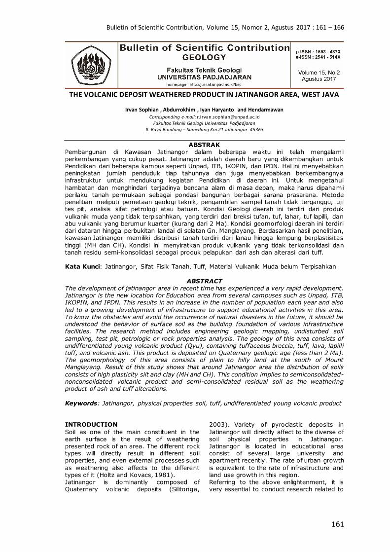
Geomorphology The geomorphology condition in Jatinangor is divided into five units: highly steep volcanic hills, steep volcanic hills, moderately gentle volcanic hills, gentle volcanic hills, and
volcanic plain based on the classification system of van Zuidam (1985), Highly steep volcanic hills geomorphology is located in the northern part of the research
area. This unit covers 10% of the total area, including Mount Manglayang. It has hilly landform, radial drainage pattern, and V-shape valley. The elevation of this
geomorphology ranges between 993 m and 1,500 m above mean sea level with slope steepness 31% until 70%. This unit is composed by andesitic volcanic rock in the form of lava.
Steep volcanic hills geomorphology is located in the north-eastern part of research area. This unit covers 17.25% of the total area. It
has hilly landform, sub-parallel drainage pattern, and V-shape valley. The elevation of this geomorphology ranges between 802 m and 1,069 m above mean sea level with slope
steepness 16% until 30%. This unit is composed by fall pyroclastic breccia deposit. Moderately gentle volcanic hills geomorphology is located from the east to the
west of research area and covers 16.75% of it. It has hilly landform, sub-parallel drainage pattern, and U-V-shape valley. The elevation of this geomorphology ranges between 709 m
and 906 m above mean sea level with slope steepness 7% until 15%. This unit is composed by fall pyroclastic breccia and tuff deposit.
Gentle steep volcanic hills geomorphology is located from the southeast until the southwest of the research are and covers 12% of it. It has hilly landform, sub-parallel drainage pattern, and U-V-shape valley. The
elevation of this geomorphology ranges between 683 m and 749 m above mean sea level with slope steepness 2% until 7%. This unit is composed by fall pyroclastic breccia
deposit. Volcanic plain geomorphology is located in the southern part and covers 44% of research area. It has plain landform, sub-parallel
drainage pattern, and U-shape valley. The elevation of this geomorphology ranges between 568 m and 690 m above mean sea level with slope steepness 0% until 1%. This unit is composed by tuff deposit.
Bulletin of Scientific Contribution, Volume 15, Nomor 2, Agustus 2017 : 161 – 166
163
Volcanic Material Distribution Based on stratigraphy sequence from older to younger reconstructed with superposition principle, volcanic materials in Jatinangor
consist of three types, those are fall pyroclastic breccia, tuff, flow pyroclastic breccia, and andesitic lava. All of the materials were deposited in the Quaternary
period. The distribution of them in the study area is shown in Figure 3. Fall pyroclastic breccia occupies the southwestern part and covers over 18% of research area, including Pasanggrahan
Village, Pasirjati Village, Pasirendah Village, and Melatiwangi Village. In general, the relative thickness of found deposit ranges from 1 m until 3 m. This fall pyroclastic
breccia has characteristics of grain supported, light brown fresh color, dark brown weathered color, and angular to sub-angular component roundness. The component has size between 0.1 cm to 30 cm as monomictic
(single type of component), that further it well classified as andesite porphyry. The matrix of this material is tuff. Based on presumption to the regional geological history
information, this fall pyroclastic breccia was resulted by the Mount Tangkubanperahu eruption. Tuff resides the eastern part and covers 8%
of research area involving Cileles Village, Cilayung Village, and Wetan Village. In common, the relative thickness of this material found in the field ranges from 3 m
up to 7 m. This tuff has light gray fresh color, brown weathered color, coarse tuff-lapilli grain size, angular-sub-angular roundness, massive structure, moderate sorting, and
moderate hardness. Its crystal fragments are quartz, pyroxene, and opaque. Based on petrography analysis, the found tuff classified as vitric tuff. Due to the presumption to the
regional geological history information, this material was deposited from Mount Tangkubanperahu and Mount Tampomas eruption. Flow pyroclastic breccia found in the
southwestern part and covers over 18% of research area including Cileunyi Village, Cinunuk Village, and Cibuesi Village. In general, the relative thickness of found
material varies from 1 m until 2 m. This flow pyroclastic breccia has characteristics of light brown fresh color, dark brown weathered color, grain supported, and angular to sub-angular component roundness. The
component has size between 0.1 cm to 30 cm as monomictic (single type of component), that further is fit classified as andesite porphyry. The matrix of this material is tuff.
The material is well described as same as the fall deposit, instead of having the bedding structure as the indication of flow deposit. Based on presumption to the regional
geological history information, this fall pyroclastic breccia was resulted by Mount Tangkubanperahu and Mount Tampomas eruption.
Bulletin of Scientific Contribution, Volume 15, Nomor 2, Agustus 2017 : 161-166
164
Andesitic lava occupies the northern part and
covers 10% of research area involving Ciporeat Village, Cilengkrang Village, and Sindangsari Village. In general, the relative thickness of the found lithology ranges from 10 m until 11 m. Andesitic lava has blackish-
gray fresh color, black weathered color, hypocristalline degree of crystallization,
aphanitic granularity, inequigranular crystal,
hipidiomorph mineral form, subhedral crystal form, mesocratic color index, and vesicular structure. It contains minerals of plagioclase, pyroxene, amphibole, feldspar and opaque. Based on these characteristics, this lava is
classified as andesite porphyry.
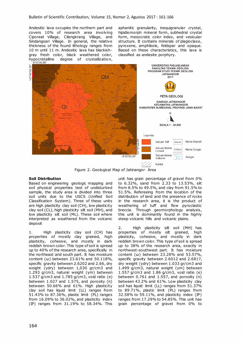
Figure 2. Geological Map of Jatinangor Area
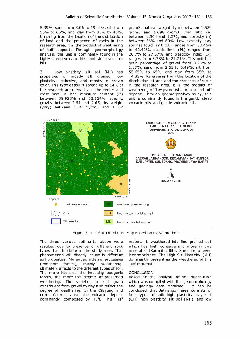
Soil Distribution
Based on engineering geologic mapping and soil physical properties test of undisturbed sample, the study area is divided into three soil units due to the USCS (Unified Soil Classification System). Three of these units
are high plasticity clay soil (CH), low plasticity clay soil (CL), high plasticity silt soil (MH), and low plasticity silt soil (ML). These soil where interpreted as weathered from the volcanic
deposit 1. High plasticity clay soil (CH) has properties of mostly clay grained, high
plasticity, cohesive, and mostly in dark reddish brown color. This type of soil is spread up to 40% of the research area, specifically in the northeast and south part. It has moisture content (ω) between 23.61% and 50.118%,
specific gravity between 2.6202 and 2.66, dry weight (γdry) between 1,030 gr/cm3 and 1.293 g/cm3, natural weight (γm) between 1.537 g/cm3 and 1.785 g/cm3, void ratio (e)
between 1.027 and 1.575, and porosity (n) between 50.66% and 61%. High plasticity clay soil has liquid limit (LL) ranges from 51.43% to 87.36%, plastic limit (PL) ranges
from 16.09% to 36.02%, and plasticity index (IP) ranges from 31.19% to 58.34%. This
unit has grain percentage of gravel from 0%
to 6.32%, sand from 2.33 to 13.53%, silt from 8.5% to 49.5%, and clay from 91.5% to 51.5%. Refereeing from the location of the distribution of land and the presence of rocks in the research area, it is the product of
weathering of tuff and flow pyroclastic breccia. Through geomorphology analysis, this unit is dominantly found in the highly steep volcanic hills and volcanic plains.
2. High plasticity silt soil (MH) has properties of mostly silt grained, high plasticity, cohesive, and mostly in dark
reddish brown color. This type of soil is spread up to 38% of the research area, exactly in northwest-southwest part. It has moisture content (ω) between 23.28% and 53.57%, specific gravity between 2.6012 and 2.6817,
dry weight (γdry) between 1.033 gr/cm3 and 1.499 g/cm3, natural weight (γm) between 1.557 g/cm3 and 1.86 g/cm3, void ratio (e) between 0.761 and 1.557, and porosity (n)
between 43.2% and 61%. Low plasticity clay soil has liquid limit (LL) ranges from 51.37% to 89.71%, plastic limit (PL) ranges from 32.58% to 59.11%, and plasticity index (IP)
ranges from 17.29% to 54.85%. This unit has grain percentage of gravel from 0% to
Bulletin of Scientific Contribution, Volume 15, Nomor 2, Agustus 2017 : 161 – 166
165
5.39%, sand from 3.06 to 19. 9%, silt from
55% to 65%, and clay from 35% to 45%. Umpiring from the location of the distribution of land and the presence of rocks in the research area, it is the product of weathering of tuff deposit. Through geomorphology
analysis, this unit is dominantly found in the highly steep volcanic hills and steep volcanic hills.
3. Low plasticity silt soil (ML) has properties of mostly silt grained, low plasticity, cohesive, and mostly in brown color. This type of soil is spread up to 14% of
the research area, exactly in the center and west part. It has moisture content (ω) between 39.923% and 53.154%, specific gravity between 2.64 and 2.65, dry weight (γdry) between 1.06 gr/cm3 and 1.162
g/cm3, natural weight (γm) between 1.589
g/cm3 and 1.698 g/cm3, void ratio (e) between 1.504 and 1.272, and porosity (n) between 56% and 60%. Low plasticity clay soil has liquid limit (LL) ranges from 33.46% to 42.42%, plastic limit (PL) ranges from
20.7% to 27.57%, and plasticity index (IP) ranges from 8.78% to 21.71%. This unit has grain percentage of gravel from 0.23% to 1.37%, sand from 2.61 to 6.49%, silt from
55.65% to 65%, and clay from 35% to 44.35%. Refereeing from the location of the distribution of land and the presence of rocks in the research area, it is the product of
weathering of flow pyroclastic breccia and tuff deposit. Through geomorphology study, this unit is dominantly found in the gently steep volcanic hills and gentle volcanic hills.
Figure 3. The Soil Distributin Map Based on UCSC method
The three various soil units above were
resulted due to presence of different rock types that distribute in the study area. That phenomenon will directly cause in different soil properties. Moreover, external processes
(exogenic forces), mainly weathering, ultimately affects to the different types of soil. The more intensive the imposing exogenic forces, the more the degree of presented
weathering. The varieties of soil grain constituent from gravel to clay also reflect the degree of weathering. In the Cilayung and north Cikeruh area, the volcanic deposit dominantly composed by Tuff. This Tuff
material is weathered into fine grained soil
which has high cohesive and more in clay mineral as (Kaolinite, Illite, Smectite, or even Montmorilonite. The High Silt Plasticity (MH) dominantly present as the weathered of this
Tuff material. CONCLUSION Based on the analysis of soil distribution
which was compiled with the geomorphology and geology data obtained, it can be concluded that Jatinangor area consists of four types of soil: high plasticity clay soil (CH), high plasticity silt soil (MH), and low
Bulletin of Scientific Contribution, Volume 15, Nomor 2, Agustus 2017 : 161-166
166
plasticity silt soil (ML). The varieties of soil
units were influenced by the presence of different rock types that distribute in the study area and also affected by external processes degree of weathering intensities. The Tuff is weathered into Silt High Plasticity
(MH), The Laharik Breccia is weathered into Silt Low Plasticity (ML) and The Volcanic Breccia is weathered into clay high Plasticity (CH).
REFERENCES Dearman, W.R. 1991. Engineering Geological
Mapping. Butterwoth-Heinemann, Oxford,
287p. Holtz, Robert D. dan William D. Kovacks.
1981. An Introduction to Geotechnical Engineering. New Jersey: Prentice Hall.
Silitonga, P.H. 2003. Peta Geologi Lembar
Bandung, Jawa, skala 1:100.000. Bandung: Direktorat Geologi.
Van Zuidam, R.A. 1985. Terrain Analysis and Classification Using Aerial Photographs.
Enschede: Institute for Aerial Survey and Earth Sciences (ITC) Netherland E-Press.


